WOODFIELD PARK Parking Study
|
|
|
- Winifred Mitchell
- 5 years ago
- Views:
Transcription

1 WOODFIELD PARK Parking Study Prepared for: Aliso Viejo Community Association 95 Argonaut, Suite 190 Aliso Viejo, CA Attn: Ms. Marilyn Smith Prepared by: DMc Engineering Civil Surveying Planning Construction 18 Technology Drive, Suite 100 Irvine, CA Phone: Fax: Contacts: Derek J. McGregor, PE, PLS, QSP JN: 1227 Feb. 27, 2014
2 Woodfield Park Parking Study TABLE OF CONTENTS I. INTRODUCTION II. PROPERTY LINE, EASEMENT AND JURISDICTIONAL BOUNDARY CONSTRAINTS III. PARKING LOT AND CONNECTIVE ROADWAY IMPROVEMENT ALTERNATIVES IV. ESTIMATED CONSTRUCTION COSTS Exhibits: A. INDEX MAP AND IMPROVEMENT ALTERNATIVES B. LSA FIGURE 1 C. EXISTING EASEMENT MAP D. COST ESTIMATE DETAIL
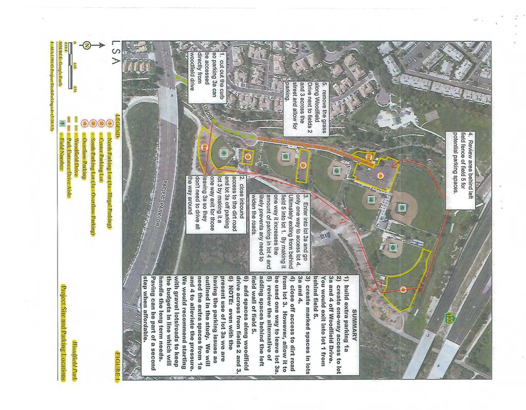
3 Woodfield Park Parking Study I. INTRODUCTION: DMc Engineering was retained by the Aliso Viejo Community Association to perform the following work efforts relative to potential development of five (5) parking lot and connective roadway improvement alternatives at Woodfield Park located at/near the intersection of Woodfield Drive and Pacific Park Drive in the City of Aliso Viejo: 1. Prepare an engineering and feasibility written report identifying property line constraints, easement constraints and jurisdictional boundary constraints for five (5) improvement alternatives. 2. Prepare parking lot and connective roadways concepts for five (5) improvement alternatives. These concepts will utilize Google Earth as its base map. 3. Prepare construction cost estimates for each of the five (5) improvements alternatives. The five (5) improvement alternatives identified by the Aliso Viejo Community Association are as follows and depicted on Exhibit A: 1. Proposed parking lot 3A 2. Proposed connector roads 3. Proposed parking lot 1A 4. Proposed parking lot 4 5. Proposed parking lot 5 The parking lot identification numbers above correspond with an exhibit prepared by LSA titled Project Site and Parking Locations (Figure 1). A copy of which is enclosed herein as Exhibit B. The work effort began with a field walk with vested stakeholders along with multiple follow-up field visits to evaluate each of the alternatives. Page 1
4 Woodfield Park Parking Study II. PROPERTY LINE, EASEMENT AND JURISDICTIONAL BOUNDARY CONSTRAINTS DMC Engineering acquired a preliminary title report for the subject property in order to evaluate property line, easement and jurisdictional boundary constraints for each of the five (5) improvement alternatives. The results of the effort are noted below and depicted on Exhibit C. A. PROPOSED PARKING LOT 3A 1. Property Line Constraints The easterly limits of alternative 3A abuts the easterly property line of the park, which is the westerly right-of-way for Aliso Creek, a regional drainage facility in the favor of the County of Orange Flood Control. 2. Easement Constraints Agencies with existing easement rights within proposed parking lot 3A: County of Orange relative to existing flood plain easement. County of Orange relative to existing access, riding and hiking easement. County of Orange relative to existing access easement. County of Orange relative to existing storm drain easement. County of Orange relative to easement grant for access over county property. 3. Judicial Boundary Constraints The County of Orange and the City of Aliso Viejo are the regulatory agencies that any construction plans will need to be cleared by and/or processed with. This is due to the County of Orange being the holder of existing easements within this proposed improvement alternative. The City of Aliso Viejo is the regulatory agency responsible for issuing appropriate permits. B. PROPOSED CONNECTOR ROADS The connector roadways are conceptually shown as one way traffic flow around the park beginning at proposed parking lot 3a and ending at the north end of proposed parking lot 5. The roadways are shown as a minimum width of 14 feet. 1. Property Line Constraints As mentioned above, the park s northerly property line is located adjacent to the southerly right-of-way of the San Joaquin Hills Transportation Corridor. There appears to be an area adjacent to the northerly property line that could accommodate necessary vehicular access that would provide circulation between areas 4 and 5, thus creating room along the park subject property. Page 2
5 Woodfield Park Parking Study 2. Easement Constraints Agencies with existing easement rights within the proposed connector roads: County of Orange relative to existing flood plain easement. County of Orange relative to existing access, riding and hiking easement. County of Orange relative to existing access easement. County of Orange relative to existing storm drain easement. County of Orange relative to easement grant for access over county property. 3. Judicial Boundary Constraints The County of Orange and the City of Aliso Viejo are the regulatory agencies that any construction plans will need to be cleared by and/or processed with. This is due to the County of Orange being the holder of existing easements within this proposed improvement alternative. The City of Aliso Viejo is the regulatory agency responsible for issuing appropriate permits. C. PROPOSED PARKING LOT 1A 1. Property Line Constraints None 2. Easement Constraints Agencies with existing easement rights within proposed parking lot 1A: Aliso Water Management Agency easement for water lines. County of Orange relative to existing flood plain easement. County of Orange relative to existing access, riding and hiking easement. County of Orange relative to existing access easement. County of Orange relative to existing storm drain easement. County of Orange relative to easement grant for access over county property. 3. Judicial Boundary Constraints The County of Orange and the City of Aliso Viejo are the regulatory agencies that any construction plans will need to be cleared by and/or processed with. This is due to the County of Orange being the holder of existing easements within this proposed improvement alternative. The City of Aliso Viejo is the regulatory agency responsible for issuing appropriate permits. D. PROPOSED PARKING LOT 4 1. Property Line Constraints None 2. Easement Constraints Agencies with existing easement rights within proposed parking lot 4: County of Orange relative to existing flood plain easement. County of Orange relative to existing access, riding and hiking easement. County of Orange relative to existing access easement. Page 3
6 Woodfield Park Parking Study County of Orange relative to existing storm drain easement. County of Orange relative to easement grant for access over county property. 3. Judicial Boundary Constraints The County of Orange and the City of Aliso Viejo are the regulatory agencies that any construction plans will need to be cleared by and/or processed with. This is due to the County of Orange being the holder of existing easements within this proposed improvement alternative. The City of Aliso Viejo is the regulatory agency responsible for issuing appropriate permits. E. PROPOSED PARKING LOT 5 1. Property Line Constraints None 2. Easement Constraints Agencies with existing easement rights within proposed parking lot 5: Aliso Water Management Agency easement for water lines. County of Orange relative to existing flood plain easement. County of Orange relative to existing access, riding and hiking easement. County of Orange relative to existing access easement. County of Orange relative to existing storm drain easement. County of Orange relative to easement grant for access over county property. 3. Judicial Boundary Constraints The County of Orange and the City of Aliso Viejo are the regulatory agencies that any construction plans will need to be cleared by and/or processed with. This is due to the County of Orange being the holder of existing easements within this proposed improvement alternative. The City of Aliso Viejo is the regulatory agency responsible for issuing appropriate permits. Page 4
7 Woodfield Park Parking Study III. PARKING LOT AND CONNECTIVE ROADWAY IMPROVEMENT ALTERNATIVES A. PROPOSED PARKING LOT 3A Concept proposes 48 new standard parking stalls and 3 new ADA compliant stalls, one (1) new driveway at Woodfield Street (connector A-1 ), New sidewalk elements connecting the proposed parking lot 3A sidewalk to the existing public sidewalk at Woodfield Street. Removal of existing sidewalk at the east end of parking lot 3 and replacing with a one way 14 wide asphalt road shown as connector A-2 and connector road B. This is depicted on Exhibit A. B. PROPOSED CONNECTOR ROADS Concept proposes four (4) new connector roads being a minimum of 14 wide asphalt road. This is depicted on Exhibit A. C. PROPOSED PARKING LOT 1A Concept proposes 14 new standard parking stalls and new sidewalk adjacent to the existing connector roadway on the west side of the park. This is depicted on Exhibit A. D. PROPOSED PARKING LOT 4 Concept proposes 58 new standard parking stalls, utility road 1 for maintenance, pedestrian sidewalk and proposed connector road D. This is depicted on Exhibit A. E. PROPOSED PARKING LOT 5 Concept proposes 57 new standard stalls, with pedestrian sidewalk connection to existing park sidewalk and connector road D. Modification options have been identified for connector road D regarding obtaining an easement for roadway purposes on the adjacent property to the north owned by the San Joaquin Hills Transportation Corridor and the County of Orange or keeping the proposed roadway on park property with modifications to baseball field 5 to accommodate connector road D. This is depicted on Exhibit A. Page 5
8 Woodfield Park Parking Study IV. ESTIMATED CONSTRUCTION COSTS Estimated construction costs for each of the five (5) improvement alternatives are detailed in Exhibit D. These estimated costs are derived from the visual field walks, development improvement alternatives and historical cost data for similar projects. The costs do not include plan preparation, processing, permit fees or construction management. Page 6
9
10
11
12
13
14
15
16
17 EXHIBIT D ESTIMATED CONSTRUCTION COST SUMMARY PROPOSED PARKING LOT 3A Demolition $ 42, Construction $ 181, Sub-total Estimated Cost $ 224, Contingency (15%) $ 33, Total Estimated Budget $ 258, PROPOSED CONNECTOR ROADS Demolition $ 4, Construction $ 33, Sub-total Estimated Cost $ 38, Contingency (15%) $ 5, Total Estimated Budget $ 43, PROPOSED PARKING LOT 1A Demolition $ 20, Construction $ 33, Sub-total Estimated $ 53, Contingency (15%) $ 8, Total Estimated Budget $ 61, PROPOSED PARKING LOT 4 Demolition $ 77, Construction $ 372, Sub-total Estimated Cost Sheet 4 $ 449, Contingency (15%) $ 67, Total Estimated Budget $ 516, PROPOSED PARKING LOT 5 Demolition $ 56, Construction $ 223, Sub-total Estimated Cost Sheet 5 $ 280, Contingency (15%) $ 42, Total Estimated Budget $ 322, plans dated J:\JOBS\1227 Woodfield Park Parking Study\Cost Estimate\CostEstimateHC
18 ESTIMATED CONSTRUCTION COST DEMOLITION DETAIL DEMOLITION, PROPOSED PARKING LOT #3A ACTIVITY UNIT MEAS QUANTITY UNIT COST TOTAL Mobilization LS 1 $ 1, $ 1, Clear and Grub (existing DG) SF $ 0.75 $ 14, Demolish Existing AC Paving TN 20 $ $ Excavate for Pavment Secton TN 1162 $ $ 23, Demolish Existing C&G and Paving for Driveway LS 1 $ 2, $ 2, Remove Existing 6' Fence LF 235 $ 5.00 $ 1, TOTAL DEMOLITION $ 42, DEMOLITION,PROPOSED CONNECTIVE ROADS ACTIVITY UNIT MEAS QUANTITY UNIT COST TOTAL Mobilization LS 1 $ 1, $ 1, Clear and Grub (Existing DG) SF 4600 $ 0.50 $ 2, Excavate Pavement Section TN 161 $ $ 1, TOTAL DEMOLITION $ 4, DEMOLITION,PROPOSED PARKING LOT #1A ACTIVITY UNIT MEAS QUANTITY UNIT COST TOTAL Mobilization LS 1 $ 1, $ 1, Clear and Grub existing landscaping SF 5250 $ 1.00 $ 5, Clear and Grub (existing DG) SF 8750 $ 0.50 $ 4, Excavate pavement section TN 980 $ $ 9, Remove Exsiting 6" Curb LF 160 $ 2.00 $ TOTAL DEMOLITION $ 20, DEMOLITION, PROPOSED PARKING LOT #4 ACTIVITY UNIT MEAS QUANTITY UNIT COST TOTAL Mobilization LS 1 $ 1, $ 1, Clear and Grub existing landscaping SF $ 1.00 $ 41, Clear and Grub (existing DG) SF 9650 $ 0.50 $ 4, Excavate pavement section TN 2948 $ $ 29, TOTAL DEMOLITION $ 77, DEMOLITION,PROPOSED PARKING LOT #5 ACTIVITY UNIT MEAS QUANTITY UNIT COST TOTAL Mobilization LS 1 $ 1, $ 1, Clear and Grub existing landscaping SF $ 1.00 $ 30, Clear and Grub (existing DG) SF 0 $ 0.50 $ - Excavate pavement section TN 1759 $ $ 17, Remove and Salvage Existing Fence LF 300 $ $ 7, TOTAL DEMOLITION $ 56, Plans Dated J:\JOBS\1227 Woodfield Park Parking Study\Cost Estimate\CostEstimateHC
19 ESTIMATED CONSTRUCTION COST CONSTRUCTION DETAIL CONSTRUCTION,PROPOSED PARKING LOT 3A Activity unit Quantity Unit Cost Total Balance and Fine Grade SF 23,033 $ 0.50 $ 11, Construct Readwood Header LF 710 $ 5.50 $ 3, Construct 3" AC / 6" AB SF 20,050 $ 6.00 $ 120, Construct PCC Sidewalk SF 3,013 $ 7.50 $ 22, Construct 12' Chain Link Fence LF 235 $ $ 9, Striping Allowance LS 1 $ 5, $ 5, ' Access Drive Approach LS 1 $ 7, $ 7, Join Existing Paving LS 1 $ 1, $ 1, Estimated Construction Cost $ 181, CONSTRUCTION,PROPOSED CONNECTIVE ROADS Activity unit Quantity Unit Cost Total Balance and Fine Grade SF 4,500 $ 0.50 $ 2, Construct Redwood Header LF 705 $ 5.50 $ 3, Construct 3" AC / 6" AB SF 4,500 $ 6.00 $ 27, Construct PCC Sidewalk SF - $ 7.50 $ - Estimated Construction Cost CONSTRUCTION,PROPOSED PARKING LOT#1A $ 33, Activity unit Quantity Unit Cost Total Balance and Fine Grade SF 12,112 $ 0.50 $ 6, Construct Redwood Header LF 435 $ 5.50 $ 2, Construct 3" AC / 6" AB SF 8,467 $ 6.00 $ 50, Construct PCC Sidewalk SF 3,645 $ 7.50 $ 27, Construct 12' Chain Link Fence LF - $ $ - Striping Allowance LS - $ 5, $ - Estimated Construction Cost CONSTRUCTION,PROPOSED PARKING LOT #4 $ 86, Activity unit Quantity Unit Cost Total Balance and Fine Grade SF 52,207 $ 0.50 $ 26, Construct Redwood Header LF 915 $ 5.50 $ 5, Construct 3" AC / 6" AB SF 46,500 $ 6.00 $ 279, Construct PCC Sidewalk SF 5,700 $ 7.50 $ 42, Construct 12' Chain Link Fence LF 300 $ $ 12, Striping Allowance LS 1 $ 7, $ 7, Estimated Construction Cost $ 372, CONSTRUCTION,PROPOSED PARKING LOT #5 Activity unit Quantity Unit Cost Total Balance and Fine Grade SF 30,250 $ 0.50 $ 15, Construct Redwood Header LF 1,761 $ 5.50 $ 9, Construct 3" AC / 6" AB SF 30,250 $ 6.00 $ 181, Construct 12' Chain Link Fence LF 300 $ $ 12, Striping Allowance LS 1 $ 5, $ 5, Estimated Construction Cost $ 223, Plans Dated J:\JOBS\1227 Woodfield Park Parking Study\Cost Estimate\CostEstimateHC
McGowin Park, LLC. B-3, Community Business District
 # 10, 11, 12 SUB2014-00024 ZON2014-00500 ZON2014-00501 SUBDIVISION, PLANNED UNIT DEVELOPMENT (East), PLANNED UNIT DEVELOPMENT (West) STAFF REPORT Date: April 3, 2014 DEVELOPMENT NAME LOCATION McGowin Park,
PLANNED UNIT DEVELOPMENT & SUBDIVISION STAFF REPORT Date: November 17, 2016
 PLANNED UNIT DEVELOPMENT & SUBDIVISION STAFF REPORT Date: November 17, 2016 DEVELOPMENT NAME SUBDIVISION NAME LOCATION Autonation Ford of Mobile Autonation Ford of Mobile Subdivision 901, 909, and 925
DAUPHIN CREEK ESTATES SUBDIVISION
 # 12 SUB-000076-2017 DAUPHIN CREEK ESTATES SUBDIVISION Engineering Comments: FINAL PLAT COMMENTS (should be addressed prior to submitting the FINAL PLAT for review and/or signature by the City Engineer):
THE CITY OF MOBILE, ALABAMA MOBILE Crry PLANNING COMMISSION
 THE CITY OF MOBILE, ALABAMA MOBILE Crry PLANNING COMMISSION LETTER OF DECISION MLK Avenue Redevelopment Corp. Attn: Michael Pierce P.O. Box 2204 Mobile, AL 36652 Re: Case #SUB2014-00040 (Subdivision) MLK
PLANNED UNIT DEVELOPMENT (East), PLANNED UNIT DEVELOPMENT (West) STAFF REPORT Date: September 18, 2014
, PLANNED UNIT DEVELOPMENT (West) STAFF REPORT Date: September 18, 2014") PLANNED UNIT DEVELOPMENT (East), PLANNED UNIT DEVELOPMENT (West) STAFF REPORT Date: September 18, 2014 DEVELOPMENT NAME LOCATION McGowin Park, LLC PLANNED UNIT DEVELOPMENT (East) 1401 Satchel Paige Drive
PLANNED UNIT DEVELOPMENT (East), PLANNED UNIT DEVELOPMENT (West) STAFF REPORT Date: September 18, 2014 DEVELOPMENT NAME LOCATION McGowin Park, LLC PLANNED UNIT DEVELOPMENT (East) 1401 Satchel Paige Drive
SECTION 7000 LAND DEVELOPMENT REQUIREMENTS
 SECTION 7000 LAND DEVELOPMENT REQUIREMENTS 7000 LAND DEVELOPMENT REQUIREMENTS... 1 7001 LEGISLATIVE AUTHORITY... 1 7001.1 LAND DEVELOPMENT... 1 7001.1.1 Title 40, Idaho Code... 1 7001.1.2 Idaho Code 40-1415
ZONING AMENDMENT & SUBDIVISION STAFF REPORT Date: March 1, 2018
 #13 SUB-000406-2018 & ZON-000407-2018 ZONING AMENDMENT & SUBDIVISION STAFF REPORT Date: March 1, 2018 NAME SUBDIVISION NAME LOCATION Creekside @ Kooiman Dairy Creekside @ Kooiman Dairy Subdivision (South
ZONING AMENDMENT, PLANNED UNIT DEVELOPMENT & SUBDIVISION STAFF REPORT Date: August 8, 2013
 ZONING AMENDMENT, PLANNED UNIT DEVELOPMENT & SUBDIVISION STAFF REPORT Date: August 8, 2013 NAME SUBDIVISION NAME PV-Magnolia, LLC Twelve Trees Subdivision LOCATION 2860, 2862 and 2866 Pleasant Valley Road
SUBDIVISION, PLANNED UNIT DEVELOPMENT, PLANNING APPROVAL, ZONING AMENDMENT, & SIDEWALK WAIVER REQUEST STAFF REPORT Date: February 17, 2010
 SUBDIVISION, PLANNED UNIT DEVELOPMENT, PLANNING APPROVAL, ZONING AMENDMENT, & SIDEWALK WAIVER REQUEST STAFF REPORT Date: February 17, 2010 APPLICANT NAME SUBDIVISION NAME DEVELOPMENT NAME LOCATION David
CONDOMINIUM REGULATIONS
 ARTICLE 37 CONDOMINIUM REGULATIONS SECTION 37.01. Purpose The purpose of this Article is to regulate projects that divide real property under a contractual arrangement known as a condominium. New and conversion
ARLINGTON COUNTY, VIRGINIA
 ARLINGTON COUNTY, VIRGINIA County Board Agenda Item Meeting of February 22, 2014 DATE: January 28, 2014 SUBJECT: Deed of Easement for a Department of Environmental Services Project Located on a Portion
ARTICLE IV: DEVELOPMENT STANDARDS
 ARTICLE IV: DEVELOPMENT STANDARDS IV-53 409 PRIVATE STREETS A private street means any way that provides ingress to, or egress from, property by means of vehicles or other means, or that provides travel
ZONING AMENDMENT & SUBDIVISION STAFF REPORT Date: November 3, 2016
 ZONING AMENDMENT & SUBDIVISION STAFF REPORT Date: November 3, 2016 APPLICANT NAME SUBDIVISION NAME David Shumer 5955 Airport Subdivision CITY COUNCIL DISTRICT District 6 5955 Airport Boulevard, 754 Linlen
PLANNED UNIT DEVELOPMENT & SUBDIVISION STAFF REPORT August 18, 2016
 PLANNED UNIT DEVELOPMENT & SUBDIVISION STAFF REPORT August 18, 2016 DEVELOPMENT NAME SUBDIVISION NAME Mullinax Ford Subdivision Mullinax Ford Subdivision LOCATION CITY COUNCIL DISTRICT District 6 Southeast
APPLICANT NAME SUBDIVISION NAME DEVELOPMENT NAME LOCATION. CITY COUNCIL DISTRICT Council District 4 PRESENT ZONING PROPOSED ZONING
 SUBDIVISION, PLANNED UNIT DEVELOPMENT, PLANNING APPROVAL, ZONING AMENDMENT, & SIDEWALK WAIVER REQUEST STAFF REPORT Date: February 17, 2010 APPLICANT NAME SUBDIVISION NAME DEVELOPMENT NAME LOCATION David
6 LOT TENTATIVE MAP OCEAN VIEWS
 6 Homes Up To 3,008 SF Each Approximately 18,900 SF Parcels With Existing House Ocean Views From Upper Floors 2 Car Garages On Grade SALE PRICE: $2,400,000 Broadway St Vista Way Cassidy St S. Myers St
COMMERCIAL SITE DEVELOPMENT GUIDE FOR UNINCORPORATED ST. CHARLES COUNTY
 COMMERCIAL SITE DEVELOPMENT GUIDE FOR UNINCORPORATED ST. CHARLES COUNTY GENERAL INFORMATION: This brochure is to be used as a guide and is not intended to amend or supersede the corresponding County ordinances
The 6-foot wide walk connecting Ventura Boulevard to Sunswept Drive, adjacent to Lot 8, Tract No. 5896
 Office of the City Engineer Los Angeles, California To the Public Works and Gang Reduction Committee Of the Honorable Council Of the City of Los Angeles April 24, 2018 Honorable Members: SUBJECT: VACATION
PLANNED UNIT DEVELOPMENT & SUBDIVISION STAFF REPORT Date: July 20, 2017
 PLANNED UNIT DEVELOPMENT & SUBDIVISION STAFF REPORT Date: July 20, 2017 DEVELOPMENT NAME SUBDIVISION NAME LOCATION Rangeline Crossing III Subdivision Rangeline Crossing III Subdivision 5289 Halls Mill
FEASIBILITY REPORT FOR PROPOSED ROAD IMPROVEMENT PROJECT OF OLD VIKING BOULEVARD NOWTHEN, MINNESOTA DECEMBER 6, Prepared by:
 FEASIBILITY REPORT FOR PROPOSED ROAD IMPROVEMENT PROJECT OF OLD VIKING BOULEVARD NOWTHEN, MINNESOTA DECEMBER 6, 2018 Prepared by: 3601 THURSTON AVENUE ANOKA, MINNESOTA 55303 TELEPHONE: (763) 427-5860 I
PLANNED UNIT DEVELOPMENT & SUBDIVISION STAFF REPORT Date: April 18, 2019
 PLANNED UNIT DEVELOPMENT & SUBDIVISION STAFF REPORT Date: April 18, 2019 DEVELOPMENT NAME SUBDIVISION NAME Springhill Village Subdivision Springhill Village Subdivision LOCATION 4350, 4354, 4356, 4358,
Cover Letter with Narrative Statement
 Cover Letter with Narrative Statement March 31, 2017 rev July 27, 2017 RE: Rushton Pointe Residential Planned Unit Development Application for Public Hearing for RPUD Rezone PL2015 000 0306 Mr. Eric Johnson,
Condominium Unit Requirements.
 ARTICLE 19 CONDOMINIUM REGULATIONS Section 19.01 Purpose. The purpose of this Article is to regulate projects that divide real property under a contractual arrangement known as a condominium. New and conversion
ARLINGTON COUNTY, VIRGINIA
 ARLINGTON COUNTY, VIRGINIA County Board Agenda Item Meeting of December 14, 2013 DATE: November 12, 2013 SUBJECT: Deed of Dedication, Deeds of Easement and Deeds of Temporary Easement and Construction
ZONING AMENDMENT, SUBDIVISION & SIDEWALK WAIVER REQUEST STAFF REPORT Date: November 16, 2006
 ZONING AMENDMENT, SUBDIVISION & SIDEWALK WAIVER REQUEST STAFF REPORT Date: November 16, 2006 NAME SUBDIVISION NAME Terhaar & Cronley Investment Partnership P & E Subdivision LOCATION 4210 and 4218 Halls
ARLINGTON COUNTY, VIRGINIA. County Board Agenda Item Meeting of July 15, 2017
 ARLINGTON COUNTY, VIRGINIA County Board Agenda Item Meeting of July 15, 2017 DATE: July 7, 2017 SUBJECT: Deed of Easement from Highland Holdings, LLC, to the County Board of Arlington County, Virginia
Chapter 22 PLANNED UNIT DEVELOPMENT.
 Chapter 22 PLANNED UNIT DEVELOPMENT. Sec. 22.1 INTENT. The use of land and the construction and use of buildings and other structures as Planned Unit Developments in Georgetown Township may be established
Bowie Marketplace Residential Detailed Site Plan Statement of Justification January 13, 2017 Revised February 2, 1017
 Bowie Marketplace Residential Detailed Site Plan Statement of Justification January 13, 2017 Revised February 2, 1017 Submitted on behalf of: BE Bowie LLC 5410 Edson Lane, Suite 220 Rockville, MD 20852
ATTACHMENT A REQUEST/BACKGROUND INFORMATION VENTURA/TYRONE REDEVELOPMENT PROJECT PROJECT OVERVIEW/REQUEST BACKGROUND Ventura Boulevard
 Revised October 28, 2016 ATTACHMENT A REQUEST/BACKGROUND INFORMATION VENTURA/TYRONE REDEVELOPMENT PROJECT Sherman Oaks, CA 91423 PROJECT OVERVIEW/REQUEST The Applicant, 14311 Ventura Development, LLC,
WRITTEN DECISION OF THE HAYDEN CITY COUNCIL REGARDING MAPLE GROVE PRELIMINARY SUBDIVISION APPLICATION (SUB-0013) HAYDEN SIGNATURE, LLC
 HAYDEN SIGNATURE, LLC") WRITTEN DECISION OF THE HAYDEN CITY COUNCIL REGARDING MAPLE GROVE PRELIMINARY SUBDIVISION APPLICATION (SUB-0013) HAYDEN SIGNATURE, LLC Application of Hayden Signature, LLC, an Idaho limited liability company,
WRITTEN DECISION OF THE HAYDEN CITY COUNCIL REGARDING MAPLE GROVE PRELIMINARY SUBDIVISION APPLICATION (SUB-0013) HAYDEN SIGNATURE, LLC Application of Hayden Signature, LLC, an Idaho limited liability company,
SUBDIVISION, PLANNED UNIT DEVELOPMENT, & PLANNING APPROVAL STAFF REPORT Date: February 1, 2007
 SUBDIVISION, PLANNED UNIT DEVELOPMENT, & PLANNING APPROVAL STAFF REPORT Date: February 1, 2007 DEVELOPMENT NAME SUBDIVISION NAME Pala Verde Mobile Home Park Subdivision Pala Verde Mobile Home Park Subdivision
ZONING AMENDMENT & SUBDIVISION STAFF REPORT Date: June 18, 2015
 ZONING AMENDMENT & SUBDIVISION STAFF REPORT Date: June 18, 2015 APPLICANT NAME SUBDIVISION NAME EAA LLC / Eryka Rogers Aaiden Place Subdivision LOCATION 2480 Government Boulevard (North side of Government
ARTICLE 14 PLANNED UNIT DEVELOPMENT (PUD) DISTRICT
 DISTRICT") ARTICLE 14 PLANNED UNIT DEVELOPMENT (PUD) DISTRICT Section 14.01 Intent. It is the intent of this Article to allow the use of the planned unit development (PUD) process, as authorized by the Michigan Zoning
ARTICLE 14 PLANNED UNIT DEVELOPMENT (PUD) DISTRICT Section 14.01 Intent. It is the intent of this Article to allow the use of the planned unit development (PUD) process, as authorized by the Michigan Zoning
May 21, ACHD Board of Commissioners Stacey Yarrington, Planner II DRH /DRH
 Development Services Department May 21, 2013 TO: FROM: SUBJECT: ACHD Board of Commissioners Stacey Yarrington, Planner II DRH13-00106/DRH13-00108 Executive Summary: This is a design review application
SUBDIVISION & PLANNING APPROVAL STAFF REPORT Date: December 1, 2016
 SUBDIVISION & PLANNING APPROVAL STAFF REPORT Date: December 1, 2016 APPLICANT NAME SUBDIVISION NAME DEVELOPMENT NAME LOCATION Board of Water and Sewer Commissioners of the City of Mobile Halls Mill Road
STONE HEDGE SUBDIVISION, UNIT 1, RESUBDIVISION OF LOT 40 & WEST COMMON AREA
 # 5 SUB-000498-2018 STONE HEDGE SUBDIVISION, UNIT 1, RESUBDIVISION OF LOT 40 & WEST COMMON AREA Engineering Comments: Must comply with the Mobile County Flood Damage Prevention Ordinance. Development shall
Plans shall be drawn at a readable scale, signed, and sealed by a Florida Registered Engineer. The application package shall include:
 CHAPTER 400. SECTION 403. PERMIT TYPES AND APPLICATIONS SITE DEVELOPMENT 403.3. Preliminary Site Plans (PSP) A. Intent and Purpose PSPs are used to identify existing site conditions and demonstrate general
PLANNED UNIT DEVELOPMENT & SUBDIVISION STAFF REPORT Date: September 15, 2016
 # 10 SUB2016-00089 PLANNED UNIT DEVELOPMENT & SUBDIVISION STAFF REPORT Date: September 15, 2016 NAME SUBDIVISION NAME LOCATION Lot 12 Laughlin Industrial Park Subdivision Lot 12 Laughlin Industrial Park
ARTICLE 13 CONDOMINIUM REGULATIONS
 ARTICLE 13 CONDOMINIUM REGULATIONS Section 13.01 Purpose. The purpose of this Article is to regulate projects that divide real property under a contractual arrangement known as a condominium. New and conversion
I. Requirements for All Applications. C D W
 108-16.1. Application checklists. Checklist for Required Submissions to the Planning Board or Zoning Board of Adjustment of Monroe Township All required submissions are to be made to the Administrative
Time Extension Staff Report
 Time Extension Staff Report Subdivision Name Lunara Subdivision File Number SUB07-00019 Approval Time Extension for Lead Agency Boise City Certification Signature of Boise City Engineer Annexation Date
PLANNED UNIT DEVELOPMENT, SIDEWALK WAIVER, & SUBDIVISION STAFF REPORT Date: November 6, 2008
 PLANNED UNIT DEVELOPMENT, SIDEWALK WAIVER, & SUBDIVISION STAFF REPORT Date: November 6, 2008 DEVELOPMENT NAME SUBDIVISION NAME LOCATION Frascati Shops, Inc. Frascati Subdivision 1120 Paper Mill Road CITY
Village of Glenview Plan Commission
 Village of Glenview Plan Commission STAFF REPORT October 14, 2014 TO: Chairman and Plan Commissioners CASE #: P2014-074 FROM: Community Development Department CASE MANAGER: Michelle House, Planner SUBJECT:
ZONING AMENDMENT & SUBDIVISION STAFF REPORT Date: July 9, 2015
 ZONING AMENDMENT & SUBDIVISION STAFF REPORT Date: July 9, 2015 APPLICANT NAME 2513 Dauphin Street, Inc. SUBDIVISION NAME Audubon Place Extension No. 3, Resubdivision of Lots 1-5 LOCATION 2513 Dauphin Street
RESOLUTION TO FORM THE REDSTONE PARKWAY BENEFIT DISTRICT
 Agenda Item No. 8A November 10, 2015 TO: FROM: SUBJECT: Honorable Mayor and City Council Attention: Laura C. Kuhn, City Manager Steven L. Hartwig, Director of Public Works/City Engineer RESOLUTION TO FORM
City of Midland Application for Site Plan Review
 City of Midland Application for Site Plan Review Submission Date: Property Owner: Mailing Address: Phone number: ( ) Cell phone: ( ) Email address: Fax: ( ) Owner s Signature: Applicant Name (if not owner):
ZONING AMENDMENT, PLANNED UNIT DEVELOPMENT & SUBDIVISION STAFF REPORT Date: September 15, 2011
 ZONING AMENDMENT, PLANNED UNIT DEVELOPMENT & SUBDIVISION STAFF REPORT Date: September 15, 2011 NAME SUBDIVISION NAME LOCATION Stratford, L.L.C. Grelot Office Park Subdivision North side of Grelot Road,
ABBREVIATION LEGEND SITE INFORMATION:
 SITE INFORMATION: Current Zone: R-3 PUD, governed by Fox Hollow 2nd MDA Basis of Elevations: Northeast Corner of Section 13, T6S, R1W, S.L.B. & M Elevation: 4599.26 (Benchmark) ABBREVIATION LEGEND Owners:
PLANNED UNIT DEVELOPMENT STAFF REPORT Date: August 20, 2015
 # 3 HOLDOVER Revised ZON2015-01733 PLANNED UNIT DEVELOPMENT STAFF REPORT Date: August 20, 2015 DEVELOPMENT NAME LOCATION Joseph N. Asarisi, P.E. North side of Airport Boulevard 212 ± West of Mckeena Court.
SUBDIVISION, PLANNING APPROVAL, & REZONING STAFF REPORT Date: June 4, 2015
 SUBDIVISION, PLANNING APPROVAL, & REZONING STAFF REPORT Date: June 4, 2015 APPLICANT NAME SUBDIVISION NAME DEVELOPMENT NAME LOCATION Board of Water & Sewer Commissioners of the City of Mobile MAWSS MLK
RECOMMENDATION. TO: CITY COUNCIL Date: APRIL 10, 2006
 TO: CITY COUNCIL Date: APRIL 10, 2006 FROM: CITY MANAGER SUBJECT: APPROVAL AND ACCEPTANCIE OF AN EASEMENT DEDICATION FOR PUBLIC STREET PURPOSES ALONG THE GLENARM STREET FRONTAGE OF 1060 SOUTH FAIR OAKS
CITY OF PAPILLION PLANNING COMMISSION STAFF REPORT MAY 31, 2017 AGENDA SHADOW LAKE 2 FINAL PLAT FP
 I. GENERAL INFORMATION CITY OF PAPILLION PLANNING COMMISSION STAFF REPORT MAY 31, 2017 AGENDA SHADOW LAKE 2 FINAL PLAT FP-17-0006 A. APPLICANT: Shadow Lake 2, LLC 15950 West Dodge Road, Suite 300 Omaha,
ZONING AMENDMENT STAFF REPORT Date: September 15, 2016
 ZONING AMENDMENT STAFF REPORT Date: September 15, 2016 NAME LOCATION Clear Water, LLC 3490 Hurricane Bay Road (Northeast corner of Hurricane Bay Road and Hurricane Bay Lane) CITY COUNCIL DISTRICT District
ARTICLE 3 DEFINITIONS
 Sections: 3-1 Rules of Construction 3-2 Definitions ARTICLE 3 DEFINITIONS SECTION 3-1 RULES OF CONSTRUCTION 3-101. a. The language set forth in these regulations shall be interpreted in accordance with
DEVELOPMENT AGREEMENT Jefferson Street Townhomes (SP 13-09) Jefferson Street Reconstruction
 Jefferson Street Reconstruction") DEVELOPMENT AGREEMENT Jefferson Street Townhomes (SP 13-09) Jefferson Street Reconstruction This Agreement is by and between Roy Mundy and Ryan Strickland, ( Developer ), and the City of Bryan, Texas (
DEVELOPMENT AGREEMENT Jefferson Street Townhomes (SP 13-09) Jefferson Street Reconstruction This Agreement is by and between Roy Mundy and Ryan Strickland, ( Developer ), and the City of Bryan, Texas (
CONSTRUCTION PLANS for HALCYON A RESIDENTIAL SUBDIVISION 6100 MIDNIGHT PASS ROAD, SARASOTA, FL 34242
 CONSTRUCTION PLANS for HALCYON A RESIDENTIAL SUBDIVISION 6100 MIDNIGHT PASS ROAD, SARASOTA, FL 34242 SECTION 18, TOWNSHIP 37 SOUTH, RANGE 18 EAST SARASOTA COUNTY, FLORIDA PID: 0030001 A DEVELOPMENT BY
ARLINGTON COUNTY, VIRGINIA. County Board Agenda Item Meeting of May 19, ISSUES: There are no outstanding issues as of the date of this report.
 ARLINGTON COUNTY, VIRGINIA County Board Agenda Item Meeting of May 19, 2018 DATE: May 9, 2018 SUBJECT: Deed of Easement from Alvaro Daniel Gabaldon and Rosemary O'Neill, as Grantors, to The County Board
Time Extension Staff Report
 Time Extension Staff Report Subdivision Name Therrin Subdivision File Number SUB06-00020 Approval Time Extension for Lead Agency Boise City Certification Signature of Boise City Engineer Annexation Date
Proposed Amendments Knoxville-Knox County Minimum Subdivision Regulations. Public Workshops
 Proposed Amendments Knoxville-Knox County Minimum Subdivision Regulations Public Workshops Restructuring EXISTING TABLE OF CONTENTS SECTION 1 PURPOSE, TITLE, AUTHORITY SECTION 2 DEFINITIONS SECTION 3 ADMINISTRATION
SPECIALIZED RESIDENTIAL APARTMENT (R.4) ZONES
 ZONES") PART 4 SPECIALIZED RESIDENTIAL APARTMENT (R.4) ZONES D.1-1 Specialized Residential (R.4) Zones In certain Instances, special circumstances dictate that variances be allowed to the permitted Uses or regulations
PART 4 SPECIALIZED RESIDENTIAL APARTMENT (R.4) ZONES D.1-1 Specialized Residential (R.4) Zones In certain Instances, special circumstances dictate that variances be allowed to the permitted Uses or regulations
Subdivision of existing two lots into three lots.
 PP-15-00189 Item No. 4-1 PC Staff Report 06/22/2015 PLANNING COMMISSION REPORT NON PUBLIC HEARING ITEM PUBLIC HEARING ON THE VARIANCE ONLY ITEM NO 4: PRELIMINARY PLAT FOR DEERFIELD WOODS SUBDIVISION NO.
Individual Well Individual Septic. Community Well 19. What is the proposed method of sewage disposal? Public. None
 Please Answer the Following Questions: (attach sheet if needed). What type of facility is being proposed? Campground Recreational Vehicle (RV) Park Both 2. What is the total acreage of the proposed facility?
APPLICATION PROCEDURE
 ANTRIM PLANNING BOARD P. O. Box 517 Antrim, New Hampshire 03440 Phone: 603-588-6785 FAX: 603-588-2969 APPLICATION FORM AND CHECKLIST FOR MINOR OR MAJOR SITE PLAN REVIEW File Date Received By APPLICATION
BEAR CREEK TOWNSHIP EMMET COUNTY, MICHIGAN. PRIVATE ROAD ORDINANCE Ordinance No. 11A-99. (to replace prior Private Road Ordinance No.
 BEAR CREEK TOWNSHIP EMMET COUNTY, MICHIGAN PRIVATE ROAD ORDINANCE Ordinance No. 11A-99 (to replace prior Private Road Ordinance No. 11-99) An Ordinance to protect the health, safety, and general welfare
PLANNED UNIT DEVELOPMENT STAFF REPORT Date: October 19, 2017
 PLANNED UNIT DEVELOPMENT STAFF REPORT Date: October 19, 2017 DEVELOPMENT NAME LOCATION Custom Boat Storage 3975 Demetropolis Road (East side of Demetropolis Road, 0.2± miles South of Halls Mill Road.)
(a) Commercial uses on Laurel Avenue, abutting the TRO District to the
 Commercial uses on Laurel Avenue, abutting the TRO District to the") 32X Zoning Code 150.36 TRANSITIONAL RESIDENTIAL OVERLAY DISTRICT. (A) Intent and purpose. (1) It is the intent of the Transitional Residential Overlay District (hereinafter referred to as the "TRO District")
32X Zoning Code 150.36 TRANSITIONAL RESIDENTIAL OVERLAY DISTRICT. (A) Intent and purpose. (1) It is the intent of the Transitional Residential Overlay District (hereinafter referred to as the "TRO District")
AMELIA LAKE SUBDIVISON, PHASES 1-2
 # 1 HOLDOVER Revised SUB2014-00089 AMELIA LAKE SUBDIVISON, PHASES 1-2 Engineering Comments: Must comply with the Mobile County Flood Damage Prevention Ordinance. Development shall be designed to comply
DRIVEWAY REQUIREMENTS
 APPLICATION FOR: RESIDENTIAL DRIVEWAY / ACCESS Zoning Review Mail: - 101 White Ave. S.E. - Live Oak, FL 32064 Office: City Hall Annex - 416 Howard Street E - Live Oak, FL 32064 Phone: 386.362.2276 ofc.
Guide to Combined Preliminary and Final Plats
 Guide to Combined Preliminary and Final Plats Introduction The Douglas County is committed to providing open, transparent application processes to the public. This Guide is provided to assist anyone interested
Level III Preliminary and Final Site Plans Development Review Application Portland, Maine Planning and Urban Development Department Planning Division
 Level III Preliminary and Final Site Plans Development Review Application Portland, Maine Planning and Urban Development Department Planning Division Portland s Planning and Urban Development Department
Frequently Asked Questions for: Drainage, Watershed and Water Quality Property Owners Near Creeks Developers and Engineers and Definitions of Terms
 FREQUENTLY ASKED QUESTIONS Draft DEFINITIONS OF TERMS Last Revised July 2, 2008 Introduction: The following questions have been organized in the categories below. We have attempted to group the questions
WESTMINSTER PARK SUBDIVISION
 WESTMINSTER PARK SUBDIVISION Engineering Comments: FINAL PLAT COMMENTS (should be addressed prior to submitting the FINAL PLAT for review and/or signature by the City Engineer): A. Provide all of the required
ZONING AMENDMENT & SUBDIVISION STAFF REPORT Date: March 7, 2013
 # 4 & 5 SUB2012-00141 & ZON2012-03157 HOLDOVER ZONING AMENDMENT & SUBDIVISION STAFF REPORT Date: March 7, 2013 APPLICANT NAME SUBDIVISION NAME LOCATION Garrard Development Services, LLC Michigan & Bay
Chapter 21 MOBILE HOME PARK REGULATIONS.
 Chapter 21 MOBILE HOME PARK REGULATIONS. Sec. 21.1 SCOPE. For the preservation of the interests of various types of residential developments which should be permitted in every community and for the protection
Commercial Requirements Packet Sheridan, Indiana Hamilton County
 Commercial Requirements Packet Sheridan, Indiana Hamilton County Town of Sheridan 506 S. Main Street Sheridan, IN 46069 317 758 5293 FAX: 317 758 2505 Needed Information For All Commercial (Office, Retail,
MAJOR SUBDIVISION APPLICATION
 Revised 2.26.18 The Department is here to assist you with your development application pursuant to the Community Development Code (CDC). This publication outlines the Major Subdivision Development Application
RESIDENTIAL CLUSTER DEVELOPMENT DISTRICT SPECIAL PERMIT RULES AND REGULATIONS OF THE PLANNING BOARD OF THE TOWN OF COHASSET, MASSACHUSETTS
 RESIDENTIAL CLUSTER DEVELOPMENT DISTRICT SPECIAL PERMIT RULES AND REGULATIONS OF THE PLANNING BOARD OF THE TOWN OF COHASSET, MASSACHUSETTS Attached: Residential Cluster Development District Special Permit
PROJECT NH 0050(99)381 PCN 6926 YANKTON COUNTY. SD HWY 50 (4 th Street) from Broadway Ave to Archery Road in Yankton, SD
381 PCN 6926 YANKTON COUNTY. SD HWY 50 (4 th Street) from Broadway Ave to Archery Road in Yankton, SD") Public Meeting/ Open House April 4, 2013 PROJECT NH 0050(99)381 PCN 6926 YANKTON COUNTY SD HWY 50 (4 th Street) from Broadway Ave to Archery Road in Yankton, SD Grading, PCC Pavement, Asphalt Concrete
Public Meeting/ Open House April 4, 2013 PROJECT NH 0050(99)381 PCN 6926 YANKTON COUNTY SD HWY 50 (4 th Street) from Broadway Ave to Archery Road in Yankton, SD Grading, PCC Pavement, Asphalt Concrete
PORT CITY COMMERCE PARK SUBDIVISION
 # 4 SUB2015-00019 PORT CITY COMMERCE PARK SUBDIVISION Engineering Comments: Must comply with the Mobile County Flood Damage Prevention Ordinance. Development shall be designed to comply with the storm
Phase 2A Lots and Parcel Identification Numbers: All located in Plat of Pleasant Hill Estates
 PLAT OF PLEASANT HILL ESTATES, VILLAGE OF WINDSOR, DANE COUNTY, WISCONSIN: AMENDMENT NO. 3 TO DEVELOPMENT AGREEMENT AND AMENDMENT NO. 1 TO UTILITY AGREEMENT RE: PLEASANT HILL ESTATES PHASE 2A Phase 2A
SUBDIVISION, PLANNED UNIT DEVELOPMENT, ZONING AMENDMENT, & SIDEWALK WAIVER STAFF REPORT Date: July 19, 2018
 SUBDIVISION, PLANNED UNIT DEVELOPMENT, ZONING AMENDMENT, & SIDEWALK WAIVER STAFF REPORT Date: July 19, 2018 NAME SUBDIVISION NAME LOCATION West Mobile Properties, LLC U.S. Machine Subdivision 556, 566,
Section 7.22: Multifamily Assisted Housing in AA-30 Residential Zone (MAHZ) [Note: an additional line will be added to the Table in Article 3, 3.1.
 [Note: an additional line will be added to the Table in Article 3, 3.1.") Section 7.22: Multifamily Assisted Housing in AA-30 Residential Zone (MAHZ) [Note: an additional line will be added to the Table in Article 3, 3.1.1A] 7.22.1 Purpose The purpose of this Special Regulation
Section 7.22: Multifamily Assisted Housing in AA-30 Residential Zone (MAHZ) [Note: an additional line will be added to the Table in Article 3, 3.1.1A] 7.22.1 Purpose The purpose of this Special Regulation
PRELMINARY PLAT CHECKLIST
 PRELMINARY PLAT CHECKLIST A. All preliminary plat submitted for approval shall be prepared by a Registered Professional Land Surveyor. B. Preliminary plats must be drawn to a scale of XXX with such accuracy
PASCO COUNTY, FLORIDA INTEROFFICE MEMORANDUM
 PASCO COUNTY, FLORIDA INTEROFFICE MEMORANDUM TO: Debra M. Zampetti Zoning/Code Compliance Administrator DATE: 3/11/11 FILE: ZN11-260 SUBJECT: Class II, Commercial Development Review - Trinity Apartments
CITY OF OCOEE LAND DEVELOPMENT CODE SUFFICIENCY TABLE WITH NOTES
 CITY OF OCOEE LAND DEVELOPMENT CODE SUFFICIENCY TABLE WITH NOTES The Sufficiency Table is a checklist to help identify the types of information and documentation needed for various types of projects. The
commission memo 9.a-b DATE: Thursday, March 7, 2019 TO: Planning & Zoning Commission FROM: Nicole Behrens, Planner I
 9.a-b commission memo DATE: Thursday, March 7, 2019 TO: Planning & Zoning Commission FROM: Nicole Behrens, Planner I RE: 9. CONDITIONAL USE LINN-MAR COMMUNITY SCHOOL DISTRICT a. Public hearing regarding
TOWN OF PORTSMOUTH PLANNING BOARD 2200 East Main Road Portsmouth, RI
 TOWN OF PORTSMOUTH PLANNING BOARD 2200 East Main Road Portsmouth, RI 02871 401-683-3717 PORTSMOUTH PLANNING BOARD Continuation of the Regular Meeting of February 8, 2017 February 15, 2017 Members Present:
FINAL SUBDIVISION AND LAND DEVELOPMENT PLAN CHECKLIST. Plan Name. Applicant's Name:
 TOWNSHIP OF UPPER ST. CLAIR FINAL SUBDIVISION AND LAND DEVELOPMENT PLAN CHECKLIST Date Filed Plan Name PLC Applicant's Name: Phone Filing Date for Final Application Final Plat 114.22. FINAL APPLICATION
R4 (SUBURBAN APARTMENT)
") Planning and Building Agency Planning Division 20 Civic Center Plaza P.O. Box 1988 (M-20) Santa Ana, CA 92702 (714) 647-5804 R4 (SUBURBAN APARTMENT) Sec. 41-290. Sec. 41-291. Sec. 41-292. Applicability
Planning and Building Agency Planning Division 20 Civic Center Plaza P.O. Box 1988 (M-20) Santa Ana, CA 92702 (714) 647-5804 R4 (SUBURBAN APARTMENT) Sec. 41-290. Sec. 41-291. Sec. 41-292. Applicability
SUBJECT PARCEL(S) Property Owner(s) TMS Number Approximate Acreage Carolina Park Development, LLC
 Property Owner(s) TMS Number Approximate Acreage Carolina Park Development, LLC") Staff Report Special Planning Commission Meeting November 19, 2014 For reference, the Zoning Code and Land Development Regulations are available online. AGENDA ITEM 5c. SKETCH PLAN APPROVAL REQUEST: Request
Staff Report Special Planning Commission Meeting November 19, 2014 For reference, the Zoning Code and Land Development Regulations are available online. AGENDA ITEM 5c. SKETCH PLAN APPROVAL REQUEST: Request
R/W PREQUALIFICATION ODOT, 3/14/2018 PROPERTY MAP SHEET
 R/W PREQUALIFICATION ODOT, 3/14/2018 3A Title Block 3B Sheet Heading 3C Station Limit Flags 3D Revision Block 3E Ownership Name and Number 3F Centerline Stationing 3G Proposed R/W and Pavement 3H Structures
CITY OF SARATOGA SPRINGS ZONING ORDINANCE
 Appendix C: 8. The Village At Saratoga Planned Unit Development (formerly 241.8) Chapter 241.8 AN ORDINANCE PROVIDING FOR THE ESTABLISHMENT OF A PLANNED UNIT DEVELOPMENT DISTRICT TO BE KNOWN AS "THE VILLAGE
TOWN OF WEST WARWICK 1170 MAIN STREET, WEST WARWICK, RI WEST WARWICK, RI PLANNING BOARD MONDAY, DECEMBER 03, :00 PM AGENDA
 TOWN OF WEST WARWICK 1170 MAIN STREET, WEST WARWICK, RI 02893 WEST WARWICK, RI 02893 PLANNING BOARD MONDAY, DECEMBER 03, 2018 6:00 PM AGENDA ITEM #1 APPROVAL OF MINUTES - Review and approval of the October
PRELIMINARY PLAN CHECKLIST Major Land Development Projects. To initiate the application, the applicant shall submit to the Administrative Officer:
 PRELIMINARY PLAN CHECKLIST Major Land Development Projects To initiate the application, the applicant shall submit to the Administrative Officer: 1. The application review fee, as established by the South
DEVELOPMENT PERMIT PRE-SUBMITTAL MEETING REQUEST FORM. PROPOSED APPLICANT S NAME OR PROJECT NAME:_Chick-Fil- A 1493 Trinity
 DEVELOPMENT PERMIT PRE-SUBMITTAL MEETING REQUEST FORM PROPOSED APPLICANT S NAME OR PROJECT NAME:_Chick-Fil- A 1493 Trinity PARCEL ID(S): _24-2-1-0000-00100-0080 (A proper and accurate parcel identification
Preliminary Plat Application & Submittal Checklist
 Planning & Community Development Department 550 Landa Street New Braunfels, Texas 78130 (830) 221-4050 www.nbtexas.org Preliminary Plat Application & Submittal Checklist Applicant Name: *Signature. * By
DAWES SWITCHING STATION SUBDIVISION
 DAWES SWITCHING STATION SUBDIVISION Engineering Comments: Must comply with the Mobile County Flood Damage Prevention Ordinance. Development shall be designed to comply with the storm water detention and
Draft Model Access Management Overlay Ordinance
 Draft Model Access Management Overlay Ordinance This model was developed using the City of Hutchinson and the Trunk Highway 7 corridor. The basic provisions of this model may be adopted by any jurisdiction
WESTMINSTER PARK PLACE SUBDIVISION
 WESTMINSTER PARK PLACE SUBDIVISION Engineering Comments: FINAL PLAT COMMENTS (should be addressed prior to submitting the FINAL PLAT for review and/or signature by the City Engineer): A. Provide all of
Community Development Department Council Chambers, 7:30 PM, September 7, 2017
 STAFF REPORT 2017-34P: Street Vacation Community Development Department Council Chambers, 7:30 PM, September 7, 2017 To: From: Re: Paul Luke, Chairman, Skokie Plan Commission Mike Voitik, Planning Technician