MONTGOMERY COUNTY PLANNING DEPARTMENT THE MARYLAND-NATIONAL CAPITAL PARK AND PLANNING COMMISSION. Description
|
|
|
- Reginald Patterson
- 5 years ago
- Views:
Transcription

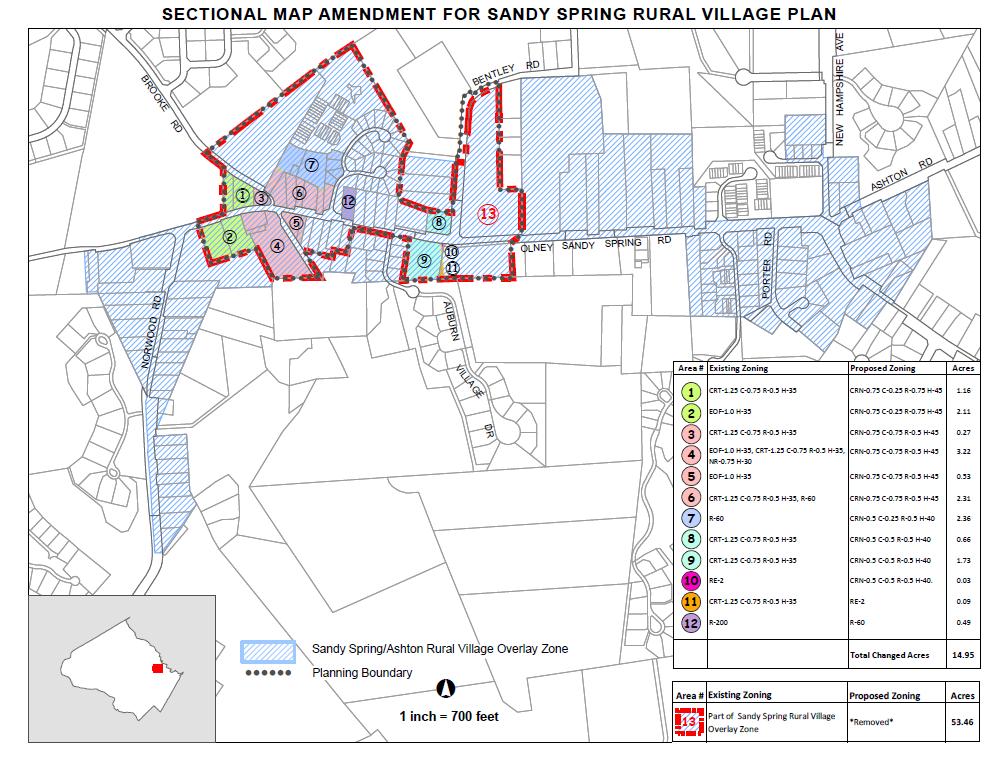
1 MONTGOMERY COUNTY PLANNING DEPARTMENT THE MARYLAND-NATIONAL CAPITAL PARK AND PLANNING COMMISSION MCPB Item No. 9 Date: 3/26/15 Sandy Spring Rural Village Plan: Sectional Map Amendment Kristin O Connor, Project Coordinator, Area 3 kristin.oconnor@montgomeryplanning.org, Roberto Duke, Urban Designer, Area 3 roberto.duke@montgomeryplanning.org, Frederick Vernon Boyd, Planner Coordinator, Area 3 frederick.boyd@montgomeryplanning.org, John Carter, Chief, Area 3 john.carter@montgomeryplanning.org Completed: 03/19/2015 Description Sandy Spring Rural Village Plan: Sectional Map Amendment (SMA) Staff Recommendation: Approval to file a Sectional Map Amendment (SMA) for the Approved and Adopted Sandy Spring Rural Village Plan. Summary The proposed Sectional Map Amendment (SMA) follows the approval and adoption of the Sandy Spring Rural Village Plan and will implement, through the SMA process, the Plan s recommendations for a rural village center for Sandy Spring and consider its rural character, mix of land uses, connections, street character and open space. The SMA covers approximately acres of the Sector Plan area; about acres of underlying zoning is proposed for reclassification. The SMA confirms the existing underlying zoning for about acres. The remaining areas consist of rights-of-way. Additionally, a portion of the Sandy Spring Ashton Overlay Zone will be removed within the Plan s boundary area.
2 Staff Recommendation Approval to file a SMA to implement recommendations of the Approved and Adopted Sandy Spring Rural Village Plan. Background On February 24, 2015, the District Council approved the Sandy Spring Rural Village Plan, by Resolution The Maryland-National Capital Park and Planning Commission adopted the approved plan on March 18, 2015, by Resolution The Sandy Spring Rural Village Plan area encompasses about acres, including rights-of-way. This SMA proposes approximately acres for reclassification: about 14 acres for the CRN mixed use zone and less than 1 acre for residential zoning. It reconfirms existing underlying zoning for about acres. The remaining areas are rights-of-way for which zones are not shown on the official zoning sheets. The District Council approved the removal of the Sandy Spring Ashton Overlay Zone on all property inside the Plan s boundary. Proposed Sectional Map Amendment The Sandy Spring Rural Village Plan contains recommendations that expand in greater detail the 1998 Plan concept for Sandy Spring as a rural village center. This new Plan provides recommendations for land use, zoning, environment and design while considering its rural village character, mix of land uses, connections, and street character, and open space. This Plan covers the Sandy Spring Village sections of the 1998 Plan. The Sectional Map Amendment implements the goals, objectives, policies, and recommendations of the Approved and Adopted Sandy Spring Rural Village Plan consistent with County policies for economic development, design excellence, and diversity of housing choice. Zoning Adjustments The Montgomery County Planning Department maintains the county s official zoning maps, and uses the State Tax Assessor s property maps as the base for drawing zoning lines. These lines generally are drawn to follow property lines, in accordance with the Zoning Ordinance. But property lines change more frequently, usually through the subdivision process, than changes to zoning maps, which occur only through District Council action. In addition, zoning maps were hand drawn for many years, and the amount of time needed for revisions meant that the State updated the property maps infrequently. Several events have combined to create the need for technical corrections to the zoning maps. In the early 1990s, the Planning Department adopted digitized mapping technology to replace hand drawn maps. It subsequently moved to a comprehensive geographic data methodology, Geographic Information Systems (GIS). At the same time, the Planning Department took responsibility for updating property information data within its GIS databases. Using GIS allows property information layers to be updated whenever plats are recorded. This means that there are now more frequent differences between property maps and adopted zoning maps. To address this issue, the District Council created a Corrective Map Amendment (CMA) procedure that can be combined with the Sectional Map Amendment. The comprehensive and technical analysis that is part of the 2
3 SMA process should uncover mapping inconsistencies. The Zoning Ordinance defines CMA corrections as line adjustments or revisions based on technical analysis of a map s line work. They are not related to more substantive errors. Planning staff will review any zoning adjustments with the Planning Board prior to Board transmittal of its SMA recommendation to the District Council. The following table lists the SMA s proposed reclassifications. The index map accompanying this memorandum shows the location of each area. Area # Existing Zoning Proposed Zoning Acres 1 CRT-1.25 C-0.75 R-0.5 H-35 CRN-0.75 C-0.25 R-0.75 H EOF-1.0 H-35 CRN-0.75 C-0.25 R-0.75 H CRT-1.25 C-0.75 R-0.5 H-35 CRN-0.75 C-0.75 R-0.5 H EOF-1.0 H-35, CRT-1.25 C-0.75 R-0.5 H-35, NR-0.75 H-30 CRN-0.75 C-0.75 R-0.5 H EOF-1.0 H-35 CRN-0.75 C-0.75 R-0.5 H CRT-1.25 C-0.75 R-0.5 H-35, R-60 CRN-0.75 C-0.75 R-0.5 H R-60 CRN-0.5 C-0.25 R-0.5 H CRT-1.25 C-0.75 R-0.5 H-35 CRN-0.5 C-0.5 R-0.5 H CRT-1.25 C-0.75 R-0.5 H-35 CRN-0.5 C-0.5 R-0.5 H RE-2 CRN-0.5 C-0.5 R-0.5 H CRT-1.25 C-0.75 R-0.5 H-35 RE R-200 R Total Changed Acres
4 The following table lists the SMA s proposed removal of part of the Sandy Spring Ashton Overlay Zone. Area # Existing Zoning Proposed Zoning Acres Part of Sandy Spring Ashton Overlay Zone *Removed* There are no pending local map amendments in the area proposed for this SMA. Recommendation Planning staff recommends that the Planning Board approve the filing of a Sectional Map Amendment to implement the goals, objectives, policies, and recommendations of the Approved and Adopted Sandy Spring Rural Village Plan. Attachments Sandy Spring Index Sheet O:\AREA_3\MASTER PLANNING\Sandy Spring\7_Sectional Map Amendmemt\SSRVP_transmit_sma_memo.doc 4
5 5
MONTGOMERY COUNTY PLANNING DEPARTMENT
 MONTGOMERY COUNTY PLANNING DEPARTMENT THE MARYLAND NATIONAL CAPITAL PARK AND PLANNING COMMISSION Corrective Map Amendment H-130 MCPB Item No. Date: 12.20.18 Lauren Stamm, Area 1, lauren.stamm@montgomeryplanning.org,
MEMORANDUM. Action. Staff recommends approval of the attached resolution.
 AGENDA ITEM #5 February 11,2014 Action MEMORANDUM February 7, 2014 TO: County Council, ~ FROM: SUBJECT: Marlene Michaelso~enior Legislative Analyst Action: Glenmont Sectional Map Amendment (G-959) Attached
MONTGOMERY COUNTY PLANNING DEPARTMENT THE MARYLAND-NATIONAL CAPITAL PARK AND PLANNING COMMISSION
 MONTGOMERY COUNTY PLANNING DEPARTMENT THE MARYLAND-NATIONAL CAPITAL PARK AND PLANNING COMMISSION MCPB Item No. Date: 4-30-15 Zoning Text Amendment (ZTA) No. 15-06, Rural Cluster Zone - Land Use and Setbacks
Staff Memorandum. From: Pamela Dunn, Joshua Sloan,
 THE MARYLAND-NATIONAL CAPITAL PARK AND PLANNING COMMISSION MONTGOMERY COUNTY PLANNING DEPARTMENT Date: May 17, 2013 Staff Memorandum To: Via: Montgomery County Planning Board Rose Krasnow, Interim Planning
MONTGOMERY COUNTY PLANNING DEPARTMENT
 MONTGOMERY COUNTY PLANNING DEPARTMENT THE MARYLAND-NATIONAL CAPITAL PARK AND PLANNING COMMISSION MCPB Item No: Date: 6//7 Corrective Map Amendments H-0 and H- Troy Leftwich, Senior Planner, Area Division:
Master Plan Review POTOMAC. Approved and Adopted March Updated January 2013
 Master Plan Review POTOMAC Approved and Adopted March 2002 BACKGROUND ZONING CODE REWRITE In 2007, the Montgomery County Council directed the Planning Department to undertake a comprehensive zoning ordinance
13 Sectional Map Amendment
 13 Sectional Map Amendment Introduction This chapter reviews land use and zoning policies and practices in Prince George s County and presents the proposed zoning in the sectional map amendment (SMA) to
MPDU Law Update 9/10/2018 1
 Montgomery Planning 9/10/2018 MPDU Law Update MPDU Law Update 9/10/2018 1 Lisa Govoni, Housing Planner lisa.govoni@montgomeryplanning.org (301) 650-5624 Background Bill 34 17 Introduced 10/31/17 Bill 38-17
Article Zones and Zoning Map
 Division 2.1. Zones Established Council Draft Article 59-2. Zones and Zoning Map Section 2.1.1. Requirements for All Zones A. Zones established in Article 59-2 must satisfy: 1. Definitions under Article
MONTGOMERY COUNTY PLANNING DEPARTMENT THE MARYLAND-NATIONAL CAPITAL PARK AND PLANNING COMMISSION
 MONTGOMERY COUNTY PLANNING DEPARTMENT THE MARYLAND-NATIONAL CAPITAL PARK AND PLANNING COMMISSION MCPB Item No. Date: 3-16-17 Rock Spring Master Plan Public Hearing Draft and Draft Zoning Text Amendment
Master Plan Review DAMASCUS. Approved and Adopted May Damascus Page 1 of 19 Updated July 2014 based on Adopted DMA
 Master Plan Review DAMASCUS Approved and Adopted May 2006 Damascus Page 1 of 19 Updated July 2014 based on Adopted DMA ONING CODE REWRITE BACKGROUND In 2007, the Montgomery County Council directed the
Master Plan Review SILVER SPRING CBD. Approved and Adopted February Updated January 2013
 Master Plan Review SILVER SPRING CBD Approved and Adopted February 2000 BACKGROUND ZONING CODE REWRITE In 2007, the Montgomery County Council directed the Planning Department to undertake a comprehensive
Use of the Zoning Ordinance
 Use of the Zoning Ordinance 1. Coordination with Other Chapters A. The use of structures and land within Montgomery County must satisfy all other applicable provisions as well as this Chapter, whether
MONTGOMERY COUNTY PLANNING DEPARTMENT THE MARYLAND-NATIONAL CAPITAL PARK AND PLANNING COMMISSION
 MONTGOMERY COUNTY PLANNING DEPARTMENT THE MARYLAND-NATIONAL CAPITAL PARK AND PLANNING COMMISSION MCPB Item No. Date: 10-11-12 Subdivision Review Waiver SRW 2011001: Big Woods Road Richard Weaver, Acting
MONTGOMERY COUNTY PLANNING DEPARTMENT
 MONTGOMERY COUNTY PLANNING DEPARTMENT THE MARYLAND-NATIONAL CAPITAL PARK AND PLANNING COMMISSION MCPB Item No. 4 Date: 2/22/18 (SRA 18-01) Minor Subdivisions Ownership Units Gregory Russ, Planner Coordinator,
MONTGOMERY COUNTY PLANNING DEPARTMENT
 MONTGOMERY COUNTY PLANNING DEPARTMENT THE MARYLAND-NATIONAL CAPITAL PARK AND PLANNING COMMISSION MCPB Item No. Date: 1-12-17 Zoning Text Amendment (ZTA) No. 16-17, Height Encroachments Townhouses GR PD
GAITHERSBURG VICINITY
 Master Plan Review GAITHERSBURG VICINITY Approved and Adopted 1985 Gaithersburg Vicinity Page 1 of 11 Updated July 2014 based on Adopted DMA ONING CODE REWRITE BACKGROUND In 2007, the Montgomery County
Planning Commission Staff Report Hearing of September 7, 2017
 Planning Commission Staff Report Hearing of September 7, 2017 County of Ventura Resource Management Agency Planning Division 800 S. Victoria Avenue, Ventura, CA 93009-1740 (805) 654-2478 vcrma.org/planning
MONTGOMERY COUNTY PLANNING DEPARTMENT THE MARYLAND NATIONAL CAPITAL PARK AND PLANNING COMMISSION
 MONTGOMERY COUNTY PLANNING DEPARTMENT THE MARYLAND NATIONAL CAPITAL PARK AND PLANNING COMMISSION Greater Lyttonsville Sector Plan, Work Session #2 Completed: 4.7.16 MCPB Item No. 6 Date: 4-14-16 Erin Banks,
Master Plan Review WESTBARD
 Master Plan Review WESTBARD Approved and Adopted 1982 Westbard Page 1 of 15 Updated July 2014 based on Adopted DMA ONING CODE REWRITE BACKGROUND In 2007, the Montgomery County Council directed the Planning
Article Zones [DIV ZONES ESTABLISHED DIV ZONING MAP
 Article 59-2. Zones [DIV. 2.1. ZONES ESTABLISHED Sec. 2.1.1. Requirements for all Zones... 2 2 Sec. 2.1.2. Zoning Categories...2 2 Sec. 2.1.3. Agricultural Zone...2 2 Sec. 2.1.4. Rural Residential Zones...
Article Zones and Zoning Map
 Article 59-2. Zones and Zoning Map [Div. 2.1. Zones Established Sec. 2.1.1. Requirements for all Zones... 2 2 Sec. 2.1.2. Zoning Categories...2 2 Sec. 2.1.3. Agricultural Zone...2 2 Sec. 2.1.4. Rural Residential
MEMORANDUM. AOENDA ITEMS #9 & 10 October 28, October 24,2014. County Council TO: FROM: Jeffrey L. zyont!~islative Attorney SUBJECT:
 AOENDA ITEMS #9 & 10 October 28, 2014 Public Hearing/Action MEMORANDUM October 24,2014 TO: FROM: SUBJECT: County Council Jeffrey L. zyont!islative Attorney Public Hearing/Action Seven Corrective Map Amendments
MONTGOMERY COUNTY PLANNING DEPARTMENT THE MARYLAND-NATIONAL CAPITAL PARK AND PLANNING COMMISSION
 MONTGOMERY COUNTY PLANNING DEPARTMENT THE MARYLAND-NATIONAL CAPITAL PARK AND PLANNING COMMISSION MCPB Consent Item Date: 12/19/13 * Consent Item Barton Property: Preliminary Plan Amendment No. 12011021A
Zoning Code Training MONTGOMERY COUNTY PLANNING DEPARTMENT. Maryland-National Capital Park and Planning Commission
 Zoning Code Training Highlights New code was adopted on March 5 & DMA was adopted on July 15. Both become effective on October 30. ZTA 14-09 was approved Sept 30 and updates, clarifies, and corrects errors
MONTGOMERY COUNTY PLANNING DEPARTMENT
 MONTGOMERY COUNTY PLANNING DEPARTMENT THE MARYLAND-NATIONAL CAPITAL PARK AND PLANNING COMMISSION MCPB Item No. 8 Date: 9-14-17 Zoning Text Amendment No. 17-XX, White Flint 2-Parklawn Overlay Zone Gregory
MONTGOMERY COUNTY PLANNING DEPARTMENT
 MONTGOMERY COUNTY PLANNING DEPARTMENT THE MARYLAND NATIONAL CAPITAL PARK AND PLANNING COMMISSION Greater Lyttonsville Sector Plan, Work Session #3 MCPB Item No. 7 Date: 5-26-16 Erin Banks, Senior Planner,
ARTICLE ZONES DIV ZONES ESTABLISHED DIV ZONING MAP
 ARTICLE 59-2. ZONES DIV. 2.1. ZONES ESTABLISHED SEC. 2.1.1. REQUIREMENTS FOR ALL ZONES... 2 2 SEC. 2.1.2. REGULATIONS FOR ESTABLISHMENT OF ZONES...2 2 SEC. 2.1.3. AGRICULTURAL ZONES...2 2 SEC. 2.1.4. RURAL
PHED DRAFT Zoning Translation
 Symbol Name Symbol Name Agricultural & Rural RDT Rural Density Transfer AR Agricultural Reserve R Rural R Rural RC Rural Cluster RC Rural Cluster LDRC Low Density Rural Cluster No area zoned LDRC. Zone
ORDINANCE NO AN ORDINANCE ESTABLISHING A UNIFORM SYSTEM FOR STREET ADDRESSING IN EMERY COUNTY
 ORDINANCE NO. 21505 AN ORDINANCE ESTABLISHING A UNIFORM SYSTEM FOR STREET ADDRESSING IN EMERY COUNTY The County Commission of the County of Emery, State of Utah, being the Legislative Body of said county,
Reporting Thailand Cadastral System in Cadastre 2014 Trends BY VUTTINAN UTESNAN. Rajamangala University of Technology Krungthep
 Reporting Thailand Cadastral System in Cadastre 2014 Trends BY VUTTINAN UTESNAN Rajamangala University of Technology Krungthep Faculty of Engineering, Bangkok, THAILAND Topics INTRODUCTION THAILAND CADASTRAL
MONTGOMERY COUNTY PLANNING DEPARTMENT THE MARYLAND-NATIONAL CAPITAL PARK AND PLANNING COMMISSION
 MONTGOMERY COUNTY PLANNING DEPARTMENT THE MARYLAND-NATIONAL CAPITAL PARK AND PLANNING COMMISSION MCPB Item No. 3 Date: 01-31-13 Preliminary Plan 120090300, Boyds Highlands Calvin Nelson, Jr. Planner Coordinator,
MONTGOMERY COUNTY PLANNING DEPARTMENT THE MARYLAND-NATIONAL CAPITAL PARK AND PLANNING COMMISSION
 MONTGOMERY COUNTY PLANNING DEPARTMENT THE MARYLAND-NATIONAL CAPITAL PARK AND PLANNING COMMISSION Farquhar Middle School MCPB Item No. 3 Date: 02-13-14 Frederick Vernon Boyd, Planner Coordinator, Area 3,
WHATCOM COUNTY HEARING EXAMINER SUMMARY OF APPEAL AND DECISION
 WHATCOM COUNTY HEARING EXAMINER RE: Administrative Appeal ) APL2010-0006 Application for ) ) FINDINGS OF FACT, Ron and Shelley Jepson ) CONCLUSIONS OF LAW, ) AND DECISION SUMMARY OF APPEAL AND DECISION
MINOR PLAT AMENDMENT APPLICATION CHECK APPLICABLE PERMIT ATTACHMENT:
 240 East Gammon Road Vineyard, Utah 84058 (801) 226-1929 MINOR PLAT AMMENDMENT APPLICATION Please Note: Attachment of request specific documents is required prior to processing your application. APPLICATION
Article Floating Zone Requirements
 Division 5.1. In General Article 59-5. Floating Zone Requirements Section 5.1.1. Zone Categories There are 4 categories of Floating zones: A. Residential Floating zones (Division 5.2); B. Commercial/Residential
October 10, All Interested Parties
 TO: RE: All Interested Parties Addendum to the Final and Supplemental Environmental Impact Statements for the Pierce County Development Regulations. Amendments are proposed in Title 2 Administration, Construction
MONTGOMERY COUNTY PLANNING DEPARTMENT
 MONTGOMERY COUNTY PLANNING DEPARTMENT THE MARYLAND-NATIONAL CAPITAL PARK AND PLANNING COMMISSION Forest Conservation Law Amendments - Modifications MCPB Item No. 7 Date: 5/24/2018 SUMMARY Mark Pfefferle,
MONTGOMERY COUNTY PLANNING DEPARTMENT THE MARYLAND-NATIONAL CAPITAL PARK AND PLANNING COMMISSION
 MONTGOMERY COUNTY PLANNING DEPARTMENT THE MARYLAND-NATIONAL CAPITAL PARK AND PLANNING COMMISSION MCPB Item Nos. 11 & 12 Subdivision Regulation Amendment (SRA) No. 14-01, Platting Exceptions Rural Village
MONTGOMERY COUNTY PLANNING DEPARTMENT THE MARYLAND-NATIONAL CAPITAL PARK AND PLANNING COMMISSION
 MONTGOMERY COUNTY PLANNING DEPARTMENT THE MARYLAND-NATIONAL CAPITAL PARK AND PLANNING COMMISSION MCPB Item No. 10 Date: 07-12-12 Zoning Text Amendment (ZTA) No. 12-09, Planned Development (PD) Zones -
In the matter of the application of FINDINGS & DECISION Daniel & Charmaine Warmenhoven (PLN020333)
") LYNNE MOUNDAY ZONING ADMINISTRATOR STATE OF CALIFORNIA COUNTY OF MONTEREY 020333 RESOLUTION NO. 000 A.P.# 243-031-002- In the matter of the application of FINDINGS & DECISION Daniel & Charmaine Warmenhoven
LYNNE MOUNDAY ZONING ADMINISTRATOR STATE OF CALIFORNIA COUNTY OF MONTEREY 020333 RESOLUTION NO. 000 A.P.# 243-031-002- In the matter of the application of FINDINGS & DECISION Daniel & Charmaine Warmenhoven
MONTGOMERY COUNTY PLANNING DEPARTMENT THE MARYLAND-NATIONAL CAPITAL PARK AND PLANNING COMMISSION
 MONTGOMERY COUNTY PLANNING DEPARTMENT THE MARYLAND-NATIONAL CAPITAL PARK AND PLANNING COMMISSION MCPB Item No. Date: 10-03-13 Preliminary Plan Amendment No. 11999034B Alvermar Woods, Lot 17 (In Response
MONTGOMERY COUNTY PLANNING BOARD
 MONTGOMERY COUNTY PLANNING BOARD T H E MARYLAND-NATIONAL CAPITAL PARK A N D P L A N N I N G C O M M I S S I O N MCPB NO. 10-144 Hearing Date: September 30, 2010 MONTGOMERY COUNTY PLANNING BOARD RESOLUTION
CHARLOTTE CODE CHAPTER 1: PURPOSE AND APPLICABILITY
 CHAPTER 1: PURPOSE AND APPLICABILITY Section 1.101. Title. These regulations shall be known and may be cited as the Zoning Ordinance of the City of Charlotte, North Carolina. Section 1.102. Authority and
UD REZONING PROJECT CASE UD DISTRICT 6 (SIGNED AGREEMENT FORMS)
") UD REZONING PROJECT CASE 18-07 UD DISTRICT 6 (SIGNED AGREEMENT FORMS) TO: FROM: PLANNING COMMISSION PLANNING AND DEVELOPMENT DATE: THURSDAY, APRIL 12, 2018 APPLICANT: REQUEST: YORK COUNTY COUNCIL TO REZONE
UD REZONING PROJECT CASE 18-07 UD DISTRICT 6 (SIGNED AGREEMENT FORMS) TO: FROM: PLANNING COMMISSION PLANNING AND DEVELOPMENT DATE: THURSDAY, APRIL 12, 2018 APPLICANT: REQUEST: YORK COUNTY COUNCIL TO REZONE
MONTGOMERY COUNTY PLANNING DEPARTMENT
 MONTGOMERY COUNTY PLANNING DEPARTMENT THE MARYLAND-NATIONAL CAPITAL PARK AND PLANNING COMMISSION MCPB Item No. 8 Date: 1-10-19 Zoning Text Amendment (ZTA) No. 18-12, Setback Exemption - Fences Gregory
LRIMS Cadastre Module
 LRIMS Cadastre Module User Requirements and Functionality (Seychelles Case Study) John Latham, NRL Renato Cumani, NRL Luigi Simeone, NRL Summary Background User Requirements Business Model Application
A Geocoded Cadastral Fabric as a Precondition for a Sustainable Land Management System
 A Geocoded Fabric as a Precondition for a Sustainable Land Management System Gottfried KONECNY, Germany; J.P. LAUZON, Canada; Abdul Salam MOHAMMED, India Key words: SDI,, Parcel Boundaries, GPS-GNSS, Land
Master Plan Review OLNEY. Approved and Adopted April Updated September
 Master Plan Review OLNEY Approved and Adopted April 2005 BACKGROUND ZONING CODE REWRITE In 2007, the Montgomery County Council directed the Planning Department to undertake a comprehensive zoning ordinance
State of Washington Project Luke Rogers, University of Washington March 2010
 State of Washington Project Luke Rogers, University of Washington March 2010 Rural Technology Initiative (RTI) developed an online tutorial on how to use the Washington State Parcel and Forestland Databases
LARAMIE COUNTY PLANNING & DEVELOPMENT DEPARTMENT
 LARAMIE COUNTY PLANNING & DEVELOPMENT DEPARTMENT Planning Building MEMORANDUM TO: FROM: Laramie County Planning Commission Nancy Trimble, Associate Planner DATE: July 13, 2017 TITLE: Review and action
PRESERVATION OF AGRICULTURE
 Master Plan Review PRESERVATION OF AGRICULTURE & RURAL OPEN SPACE Approved and Adopted 1980 BACKGROUND ZONING CODE REWRITE In 2007, the Montgomery County Council directed the Planning Department to undertake
Article Optional Method Requirements
 Article 59-6. Optional Method Requirements [DIV. 6.1. MPDU DEVELOPMENT IN RURAL RESIDENTIAL AND RESIDENTIAL ZONES Sec. 6.1.1. General Requirements... 6 2 Sec. 6.1.2. General Site and Building Type Mix...
MEMORANDUM. Action-Revised Zoning Text Amendment 16-20, Overlay Zone -Bethesda
 AGENDA ITEM #7 July 11, 2017 Action MEMORANDUM TO: FROM: County Council A/' Jeffrey L. Zyontz, {enior Legislative Analyst July 7, 2017 SUBJECT: Action-Revised Zoning Text Amendment 16-20, Overlay Zone
Implementation. Approved Master Plan and SMA for Henson Creek-South Potomac 103
 Implementation Approved Master Plan and SMA for Henson Creek-South Potomac 103 104 Approved Master Plan and SMA for Henson Creek-South Potomac Sectional Map Amendment The land use recommendations in the
Innsbruck Val Moritz AFP of Lot 46, Lot 47, & Amended Lot 48 Block 17 Amended Final Plat Adjustment of Interior Lot Lines
 Innsbruck Val Moritz AFP of Lot 46, Lot 47, & Amended Lot 48 Block 17 Amended Final Plat Adjustment of Interior Lot Lines APPLICATION: AMENDED FINAL PLAT HEARING DATES: Planning Commission: 8 November
COUNTY OF HUMBOLDT. To: Board of Supervisors. From: Planning and Building Department. Agenda Section: Public Hearing
 COUNTY OF HUMBOLDT For the meeting of: 12/11/2018 File #: 18-1604 To: Board of Supervisors From: Planning and Building Department Agenda Section: Public Hearing SUBJECT: 10:00 a.m. - Zoning Text Amendments
TOWN OF BROOKLINE, NEW HAMPSHIRE
 TOWN OF BROOKLINE, NEW HAMPSHIRE BUILDOUT ANALYSIS DECEMBER, 2003 Prepared by the Nashua Regional Planning Commission TABLE OF CONTENTS Introduction... 1 I. Methodology... 1 A. PARCEL REVIEW... 1 B. DEVELOPMENT
Residential Capacity Estimate
 Residential Capacity Estimate Montgomery County Department of Park & Planning Research & Technology Center January 2005 Current plans allow 75,000 more housing units. by Matthew Greene, Research Planner
Planning Board Work Session #2 June 7, 2018
 Planning Board Work Session #2 June 7, 2018 1 WORK SESSION #2: OVERVIEW Summary of Work Session #1 Single-Family Parcels at Robindale Drive Department of Recreation Administrative Offices Land Use and
Land Details. Bridging the Gap between Assessor Acres and GIS Acres
 Land Details Bridging the Gap between Assessor Acres and GIS Acres What are Assessor Acres? It is a legally agreed upon approximation of size Applies to larger parcels Has deep historical roots. Thomas
MEMORANDUM. Action - Revised Zoning Text Amendment 16-20, Overlay Zone - Bethesda
 AGENDA ITEM #4B July 18, 2017 Action MEMORANDUM July 11, 2017 TO: FROM: SUBJECT: County Council flj- Jeffrey L. Zyont&enior Legislative Analyst Action - Revised Zoning Text Amendment 16-20, Overlay Zone
MONTGOMERY COUNTY PLANNING DEPARTMENT THE MARYLAND-NATIONAL CAPITAL PARK AND PLANNING COMMISSION
 MONTGOMERY COUNTY PLANNING DEPARTMENT THE MARYLAND-NATIONAL CAPITAL PARK AND PLANNING COMMISSION MCPB Item No. 3 Date: 05-03-12 Proposed Zoning Text Amendment Revising the Requirements for permitting Accessory
2018 RESIDENTIAL CAPACITY AND VACANT LAND ANALYSIS. Martin County Board of County Commissioners
 2018 RESIDENTIAL CAPACITY AND VACANT LAND ANALYSIS Martin County Board of County Commissioners Approved February 13, 2018 INTRODUCTION Objective 4.1D of the Martin County Comprehensive Growth Management
SUBDIVISION APPLICATION (CHECK THE BOX THAT APPLIES)
") GARFIELD COUNTY Building & Planning Department 108 8 th Street, Suite 401 Glenwood Springs, Colorado 81601 Telephone: 970.945.8212 Facsimile: 970.384.3470 www.garfield-county.com SUBDIVISION APPLICATION
GARFIELD COUNTY Building & Planning Department 108 8 th Street, Suite 401 Glenwood Springs, Colorado 81601 Telephone: 970.945.8212 Facsimile: 970.384.3470 www.garfield-county.com SUBDIVISION APPLICATION
ARTICLE III GENERAL PROCEDURES, MINOR PLANS AND FEE SCHEDULES
 ARTICLE III GENERAL PROCEDURES, MINOR PLANS AND FEE SCHEDULES 301. Prior to Submission a. Copies of this Ordinance shall be available on request, at cost, for the use of any person who desires information
WSSC EASEMENT PREPARATION AND SUBMITTAL GUIDELINES
 WSSC EASEMENT PREPARATION AND SUBMITTAL GUIDELINES PREPARED BY THE LAND SERVICES SECTION ENGINEERING AND ENVIRONMENTAL SERVICES DIVISION UPDATED SEPTEMBER, 2017 Page 1 TABLE OF CONTENTS TABLE OF CONTENTS...
New Clarity & Relief Proposed for Leases
 Last year, the Financial Accounting Standards Board (FASB) issued Accounting Standards Update (ASU) 2016-02, Leases (Topic 842), which requires lessees to recognize all leases with terms greater than 12
MONTGOMERY COUNTY PLANNING DEPARTMENT THE MARYLAND-NATIONAL CAPITAL PARK AND PLANNING COMMISSION
 MONTGOMERY COUNTY PLANNING DEPARTMENT THE MARYLAND-NATIONAL CAPITAL PARK AND PLANNING COMMISSION MCPB Item No.: Date: 11-12-15 15931 Frederick Road (CarMax) Annexation Request ANX2015-00145 Patrick Butler,
Planning & Permit Center Comprehensive Plan Amendment Petition to Rezone Pursuant to SCC and
 Planning & Permit Center Comprehensive Plan Amendment Petition to Rezone Pursuant to SCC 14.16.900 and 14.08.020 PL#: Date Received Please submit the following Special Use application requirements. 1.
MASS REGISTRATION OF LAND PARCELS USING FIT-FOR-PURPOSE LAND ADMINISTRATION: PROCEDURES AND METHODS
 MASS REGISTRATION OF LAND PARCELS USING FIT-FOR-PURPOSE LAND ADMINISTRATION: PROCEDURES AND METHODS TAREK ZEIN Hansa Luftbild AG, Germany zein@hansaluftbild.de Paper prepared for presentation at the 2017
LARAMIE COUNTY PLANNING & DEVELOPMENT DEPARTMENT
 LARAMIE COUNTY PLANNING & DEVELOPMENT DEPARTMENT Planning Building MEMORANDUM TO: FROM: Laramie County Planning Commission Nancy M. Trimble, Associate Planner DATE: July 13, 2017 TITLE: Review and action
Using GIS To Manage Surface Ownership and Right-Of-Way
 Using GIS To Manage Surface Ownership and Right-Of-Way Jeff Bute - Sr. Land Maintenance Rep. / GIS Analyst Jeff was formerly a Property Tax Right of Way and Claims field agent for the company. Now he uses
GIS Based Tools for County Road Management Right-of-Way Land Value Analysis. January 12, 2012
 GIS Based Tools for County Road Management Right-of-Way Land Value Analysis January 12, 2012 Reasons for Needing Accurate Land Values Asset Management 1999 GASB Statement 34 Corridor Studies Scoping Studies
APPENDIX C: FINAL PLAT REVIEW CHECKLIST
 FINAL PLAT REVIEW CHECKLIST The Office of Permitting Services processes final record plats though the City agencies for review and approval and ultimate recording of the final plat at the Orange County
MONTGOMERY COUNTY PLANNING DEPARTMENT THE MARYLAND-NATIONAL CAPITAL PARK AND PLANNING COMMISSION
 MONTGOMERY COUNTY PLANNING DEPARTMENT THE MARYLAND-NATIONAL CAPITAL PARK AND PLANNING COMMISSION MCPB Item Date: 06/01/17 900 Thayer Avenue: Project Plan Amendment No. 92005003B and Site Plan Amendment
WHATCOM COUNTY AGRICULTURAL LAND COVER ANALYSIS TABLE OF CONTENTS. Planning & Development Services: Agricultural Program May 13, 2013
 WHATCOM COUNTY AGRICULTURAL LAND COVER ANALYSIS Planning & Development Services: Agricultural Program May 13, 2013 Version 2.3 Includes revisions to Rural Study Areas and other updates as recommended by
Steamboat Ski Area Zone Change
 ACTIVITY #: PL-15-1041 Steamboat Ski Area Zone Change HEARING DATES: Planning Commission: 11/19/15 at 6:00 pm Board of County Commissioners 12/7/15 at 1:30 pm pre-hearings: Board of County Commissioners:
INFORMATION SUBJECT: UPDATE ON COMMUNITY ENGAGEMENT PLAN FOR PROPOSED GOOGLE DEVELOPMENT AT DIRIDON STATION
 city of C: San Iose CAPITAL OF SILICON VALLEY TO: HONORABLE MAYOR AND CITY COUNCIL Memorandum FROM: Kim Walesh Lee Wilcox SUBJECT: SEE BELOW DATE: December 19, 2017 Approved \ Date V; Tv ' - INFORMATION
HISTORIC PRESERVATION OVERLAY DISTRICTS
 CITY OF SHREVEPORT, LOUISIANA HISTORIC PRESERVATION OVERLAY DISTRICTS Frequently Asked Questions (FAQs) The Metropolitan Planning Commission www.shreveportcaddmpc.com FAQs: March 12, 2019 Benefits of Preservation
Cadastral and Right of Way Data Sharing
 Cadastral and Right of Way Data Sharing May 2010 TRS 1006 This Transportation Research Synthesis (TRS) provides summaries of recent research and implementation efforts on a topic of current interest. Online
MONTGOMERY COUNTY PLANNING DEPARTMENT THE MARYLAND-NATIONAL CAPITAL PARK AND PLANNING COMMISSION
 MONTGOMERY COUNTY PLANNING DEPARTMENT THE MARYLAND-NATIONAL CAPITAL PARK AND PLANNING COMMISSION St. Andrews Episcopal School, Forest Conservation Plan Amendment, CBA 1389C (In response to violation) MCPB
Description of Zoning Resolution Amendment: (attach additional sheets if necessary)
") CARBON COUNTY www.carbonwy.com Department of Planning and Development 215 West Buffalo, Suite 336 Application Fee $200.00 (plus public notice cost) Rawlins, WY 82301 Fee Paid $ Date Tel (307) 328-2651
CARBON COUNTY www.carbonwy.com Department of Planning and Development 215 West Buffalo, Suite 336 Application Fee $200.00 (plus public notice cost) Rawlins, WY 82301 Fee Paid $ Date Tel (307) 328-2651
2017_10_MIKES_SWEETMAN_OE_PC.PDF
 1. OCTOBER PLANNING COMMISSION AGENDA Documents: OCTOBER 2017.PDF 1.I. MIKES/SWEETMAN OUTRIGHT EXEMPTIONS Documents: 2017_10_MIKES_SWEETMAN_OE_PC.PDF DEPARTMENT OF PLANNING AND ZONING 308 Byers Ave P.O.
Relationship Between Building Permits, Housing Starts, and Housing Completions
 Relationship Between Building Permits, Housing Starts, and Housing Completions We are frequently asked why the building permits, housing starts, and housing completions series do not match over time, both
Technical Corrections and Improvements to Recently Issued Standards
 Two Proposed Accounting Standards Updates Issued: September 27, 2017 Comments Due: November 13, 2017 Technical Corrections and Improvements to Recently Issued Standards I. Accounting Standards Update No.
MONTGOMERY COUNTY PLANNING DEPARTMENT THE MARYLAND-NATIONAL CAPITAL PARK AND PLANNING COMMISSION
 MONTGOMERY COUNTY PLANNING DEPARTMENT THE MARYLAND-NATIONAL CAPITAL PARK AND PLANNING COMMISSION MCPB Item No.: Date: 06-21-12 The Plantations, Preliminary Plan -120090240 Benjamin Berbert, Senior Planner,
ARTICLE OPTIONAL METHOD REGULATIONS
 ARTICLE 59-6. OPTIONAL METHOD REGULATIONS DIV. 6.1. MPDU DEVELOPMENT IN RURAL RESIDENTIAL AND RESIDENTIAL ZONES SEC. 6.1.1. GENERAL REQUIREMENTS... 6 2 SEC. 6.1.2. GENERAL SITE AND BUILDING T PE MIX...
Jcouncilmembers should bring their copy of the Plan to the meeting.i. PHED Committee #lb October 30, 2017 MEMORANDUM. October 26, 2017 TO:
 PHED Committee #lb October 30, 2017 MEMORANDUM October 26, 2017 TO: FROM: Planning, Housing, and Economic Development (PHED) Committee Marlene Michaelso1ltnior Legislative Analyst SUBJECT: White Flint
MCPB Item # June 16, 2016 MEMORANDUM. June 9, 2016 Montgomery County Planning Board
 MEMORANDUM MCPB Item # June 16, 2016 June 9, 2016 To: VIA: FROM: Montgomery County Planning Board Michael F. Riley, Director of Parks Mitra Pedoeem, Acting Deputy Director of Parks Dr. John E. Hench, Chief,
MONTGOMERY COUNTY PLANNING DEPARTMENT THE MARYLAND-NATIONAL CAPITAL PARK AND PLANNING COMMISSION
 MONTGOMERY COUNTY PLANNING DEPARTMENT THE MARYLAND-NATIONAL CAPITAL PARK AND PLANNING COMMISSION MCPB Item No. 10 Date: 6-20-13 Zoning Text Amendment (ZTA) No. 13-05, US 29 Overlay Zone Standards Gregory
Innovative Local Government Land Conservation Techniques
 Innovative Local Government Land Conservation Techniques Three new successful land conservation programs used in Maryland by Baltimore and Carroll Counties are worthy of further examination. Baltimore
PLANNING COMMISSION STAFF REPORT
 PLANNING COMMISSION STAFF REPORT TO: FROM: Planning Commission Kathleen Mallory, Planner Manager Christopher Williamson, Planning Consultant DATE: October 18, 2018 SUBJECT: Study Session on the 2030 General
MONTGOMERY COUNTY PLANNING BOARD
 MONTGOMERY COUNTYPLANNING BOARD T H E MARYLAND-NATIONAL CAPITAL PARK A N D P L A N N I N G C O M M I S S I O N MCPB NO. 10-100 Preliminary Plan No. 120100210 Date of Hearing: July 1, 2010 MONTGOMERY COUNTY
MONTGOMERY COUNTY PLANNING DEPARTMENT THE MARYLAND-NATIONAL CAPITAL PARK AND PLANNING COMMISSION
 MONTGOMERY COUNTY PLANNING DEPARTMENT THE MARYLAND-NATIONAL CAPITAL PARK AND PLANNING COMMISSION MCPB Item No. Date: 5/11/17 (ZTA 16-03) Bed & Breakfast Standards & Accessory Residential Uses Tenancy Duration
RESOLUTION NO. RD:EEH:LCP
 RD:EEH:LCP 3-29-16 RESOLUTION NO. A RESOLUTION OF THE COUNCIL OF THE CITY OF SAN JOSE VACATING A LANDSCAPE EASEMENT AND PORTION OF STREET EASEMENT RESTRICTING VEHICULAR ACCESS ON PRIVATE PROPERTY LOCATED
MINOR SUBDIVISION COMMITTEE COUNTY OF MONTEREY, STATE OF CALIFORNIA
 MINOR SUBDIVISION COMMITTEE COUNTY OF MONTEREY, STATE OF CALIFORNIA RESOLUTION NO. 05010 In the matter the application GIANNINI FAMILY LIMITED PARTNERSHIP (PLN040273) APN# 113-071-006-000 FINDINGS & DECISION
MONTGOMERY COUNTY PLANNING DEPARTMENT THE MARYLAND-NATIONAL CAPITAL PARK AND PLANNING COMMISSION
 MONTGOMERY COUNTY PLANNING DEPARTMENT THE MARYLAND-NATIONAL CAPITAL PARK AND PLANNING COMMISSION MCPB Item No. 9 Date: 06-21-12 Proposed Zoning Text Amendment Revising the Requirements for Permitting Accessory
Property Appraisal Division Finance Department Anchorage: Performance. Value. Results.
 Anchorage: Performance. Value. Results. Mission Provide a fair and equitable basis for taxation in the Municipality of Anchorage in conformance with State law and professional standards. Core Services
QUESTIONNAIRE. 1. Authorizing statute(s) citation West Virginia Code and 11-1C-4(d)
 citation West Virginia Code and 11-1C-4(d)") QUESTIONNAIRE (Please include a copy of this form with each filing of your rule: Notice of Public Hearing or Comment Period; Proposed Rule, and if needed, Emergency and Modified Rule.) DATE: 6/8/15 TO:
QUESTIONNAIRE (Please include a copy of this form with each filing of your rule: Notice of Public Hearing or Comment Period; Proposed Rule, and if needed, Emergency and Modified Rule.) DATE: 6/8/15 TO: