MONTGOMERY COUNTY PLANNING DEPARTMENT THE MARYLAND NATIONAL CAPITAL PARK AND PLANNING COMMISSION
|
|
|
- Gertrude Jenkins
- 5 years ago
- Views:
Transcription

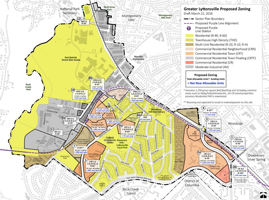
1 MONTGOMERY COUNTY PLANNING DEPARTMENT THE MARYLAND NATIONAL CAPITAL PARK AND PLANNING COMMISSION Greater Lyttonsville Sector Plan, Work Session #2 Completed: MCPB Item No. 6 Date: Erin Banks, Senior Planner, Area 1, erin.banks@montgomeryplannng.org, Robert Kronenberg, Chief, Area 1, robert.kronenberg@montgomeryplanning.org, Melissa Williams, Senior Planner, Melissa.williams@montgomeryplanning.org Laura Shipman, Urban Designer, laura.shipman@montgomeryplanning.org, Rick Liu, Economic and Development Specialist, rick.liu@montgomeryplanning.org, Matt Folden, Planner/Coordinator, matthew.folden@montgomeryplanning.org, David Anspacher, Planner/Coordinator, david.anspacher@montgomeryplanning.org, Tina Schneider, Senior Planner, tina.schneider@montgomeryplanning.org Sandra Youla, Senior Planner, sandra.youla@montgomeryplanning.org, Chuck Kines, Planner/Coordinator, Charles.Kines@montgomeryplanning.org, DESCRIPTION Greater Lyttonsville Sector Plan: Work Session #2 Work session #2 will include a detailed discussion of the zoning and building height recommendations for the 12 sites outlined in the Public Hearing Draft, along with the zoning and building height changes requested by property owners and community members. The discussion will be on a district-by-district basis beginning with the Industrial/Institutional Area District, followed by the Brookville Road/Lyttonsville Station Area District, followed by the Residential Area District, and ending with the Woodside/16 th Street Station Area District. DISCUSSION Zoning Approach The previous work session provided an overview of the zoning strategy as it relates to the recommended density and height increases across the Sector Plan area. Greater Lyttonsville s established single family neighborhoods are maintained with no zoning changes. Changes are primarily recommended on sites currently zoned for multi-family development within a half mile of the two proposed light rail transit stations within the Plan area. Staff s primary goal for the Plan is to create more logical industrial and residential areas by utilizing the future Purple Line and Capital Crescent Trail as geographic transition areas. As a result, Staff has sought to preserve the majority of the industrial area, but expand retail opportunities through a CRT floating zone along a portion of Brookville Road that could be applied following construction of the Purple Line light rail. CONCLUSION Following the April 14, 2016 work session, Staff will meet with the Planning Board for two more work sessions. These work sessions will include a work session on May 19, 2016 focused on infrastructure and parks and open space and then a work session on June 3, 2016 to review the final edits to the Public
2 Hearing Draft and a vote out. SCHEDULE The following schedule provides a tentative timeline for future work sessions and Plan milestones: Spring 2016 Planning Board Work Sessions Work Session #1: Overview of History, Zoning, & Affordable Housing Work Session #2: Site by Site Zoning Analysis Work Session #3: Transportation, Schools, Parks & Open Space Work Session #4: Review of Edits and Vote Out Summer 2016 Planning Board approves Greater Lyttonsville Sector Plan for transmittal to County Executive and County Council Fall 2016 County Council public hearing ATTACHMENTS Zoning and Requested Changes Chart Zoning Calculations Worksheet and Development Yields Map
3 SECTOR PLAN SITE # PROPERTY ADDRESS 8904 ALBERT STEWART LN PROPERTY OWNER NAME LYTTONSVILLE LAND COMPANY LLC CURRENT ZONING SECTOR PLAN RECOMMENDED ZONING RT-15.0 R LINDEN TSP ASSOCIATES R-90 0 LINDEN LN U.S. ARMY R FRASER AVE DIRECT MAIL PRESS INC R FRASER AVE DIRECT MAIL PRESS INC R FRASER AVE GREAT SPACES LLC R FRASER AVE GREAT SPACES LLC R FRASER AVE JOHN JUENEMANN R FRASER AVE THOMAS & J W TERMINI R FRASER AVE 9345 FRASER LLC R FRASER AVE 9347 FRASER AVE LLC R-90 0 BROOKVILLE RD MONTGOMERY COUNTY R BROOKVILLE RD MONTGOMERY COUNTY R BROOKVILLE RD MONTGOMERY COUNTY R-60 PROPERTY OWNER REQUESTED ZONING SUMMARY OF COMMUNITY CONCERNS RESIDENTIAL ZONING PROVIDES VALUABLE BUFFER IN THIS LOCATION
4 SECTOR PLAN SITE # 10 PROPERTY ADDRESS 8913 BROOKVILLE RD 8907 BROOKVILLE RD 8917 BROOKVILLE RD 8850 BROOKVILLE RD 0 BROOKVILLE RD PROPERTY OWNER NAME CURRENT ZONING FANGMEYER ROBERT A ET AL FANGMEYER ROBERT A ET AL CAMPANERO PROPERTIES LLC ZIMMERMAN CRAIG A ET AL CAMPANARO PROPERTIES LLC 8943 BROOKVILLE RD ZANOFF FAMILY LLC 8921 BROOKVILLE RD ZANOFF FAMILY LLC 8905 BROOKVILLE RD 8951 BROOKVILLE RD 8827 BROOKVILLE RD GRAY ROBERT L JR & JACQUELYN A 8951 BROOKVILLE ROAD LLC UNITED THERAPEUTICS CORP 8901 BROOKVILLE RD 8901 BROOKVILLE LLC SECTOR PLAN RECOMMENDED ZONING PROPERTY OWNER REQUESTED ZONING SUMMARY OF COMMUNITY CONCERNS FLOATING ZONE BRINGS UNCERTAINTY AND DISCOURAGES REINVESTMENT BY CURRENT BUSINESS OWNERS IN AREA; RESIDENTIAL UNITS NOT COMPATIBLE WITH INDUSTRIAL USES KANSAS AVE LRS GROUP LLC 2323 STEWART AVE DIGREGORIO STEWART AVE LLC CRN-1.5, C-0.25, R-1.5, H- 65' CRN-1.5, C-0.25, R-1.5, H- 65' TOWNHOMES MORE COMPATIBLE WITH SURROUNDING SINGLE FAMILY HOMES-REZONE ACCORDINGLY
5 SECTOR PLAN SITE # PROPERTY ADDRESS PROPERTY OWNER NAME CURRENT ZONING SECTOR PLAN RECOMMENDED ZONING PROPERTY OWNER REQUESTED ZONING SUMMARY OF COMMUNITY CONCERNS 8909 BROOKVILLE RD CAMPANARO PROPERTIES CRT-2.5, C-0.25, R-2.5, H- 70' CRT-3.0, with increased height 8A 0 BROOKVILLE RD 2401 LYTTONSVILLE RD BROOKVILLE VENTURES LLC FRIENDS NON PROFIT HOUSING R-20, RT CRT-2.5, C-0.25, R-2.5, H- 70' CRT-2.5, C-0.25, R-2.5, H- 70' MAXIMUM PERMITTED FAR SHOULD BE 1.5 WITH A UNIT CAP OF 400 IN LYTTONSVILLE/ROSE MARY HILLS AREA 2445 LYTTONSVILLE RD C & C APTS ASSOC LTD RH CRT-2.5, C-0.25, R-2.5, H- 70' 8B 0 STEWART AVE SERRA JOSE M TRUST CRN-0.25, C-0, R-0.25, H-35' AESTHETICS OF FUTURE SWM FACILITY LYTTONSVILLE RD WASHINGTON SUBURBAN SANITARY COMMISSION R-60, IM-2.5 H- R-20 6A 6B 8800 LANIER DR 8800 LANIER DR PADDINGTON SQUARE DEV CORPORATION PADDINGTON SQUARE DEV CORPORATION R-20 CRT-1.5, C-0.25, R-1.5, H- 65' R-20 THD 1.5 OVER ENTIRE SITE, REMOVE SPLIT ZONING 1.5 OVER ENTIRE SITE, REMOVE SPLIT ZONING COMPATIBILITY WITH ADJACENT SINGLE FAMILY NEIGHBORHOOD 5A 2535 ROSS RD FR ROLLINGWOOD INC R-20 5B 2450 LYTTONSVILLE RD MNCPPC R-20 CRT-1.5, C-0.25, R-1.5, H- 85' CRT-1.5, C-0.25, R-1.5, H- 85'
6 SECTOR PLAN SITE # PROPERTY ADDRESS LYTTONSVILLE RD PROPERTY OWNER NAME PARK SUTTON CONDOMINIUM CURRENT ZONING TH ST BRADFORD PLACE LLC R-10 2A TH ST SUMMIT HILLS LLC SECTOR PLAN RECOMMENDED ZONING RH R-10 R-10, CRT- 0.75, C-0.75, R-0.25, H-45' 2B TH ST SUMMIT HILLS LLC R-10 CRT-2.5, C-0.25, R-2.5, H- 70' CRT-2.5, C-0.25, R-2.5, H- 70' CR-3.0, C-0.75, R-3.0, H- 145' PROPERTY OWNER REQUESTED ZONING CR-5.0, C-1.0, R-4.0, H-200' CR-5.0, C-1.0, R-4.0, H-200' SUMMARY OF COMMUNITY CONCERNS CONSIDER GREATER DENSITY IN THIS LOCATION AND LESS DENSITY NEAR LYTTONSVILLE STATION CONSIDER GREATER DENSITY IN THIS LOCATION AND LESS DENSITY NEAR LYTTONSVILLE STATION TH ST ANCAR ASSOCIATES CRT-0.75, C- 0.75, R-0.5, H-40' CRT-3.0, C-1.5, R-2.0, H-70' COMPATIBILITY WITH ADJACENT SINGLE FAMILY NEIGHBORHOOD
7 Greater Lyttonsville Zoning Draft 3/22/2016 Zoning Definitions: Commercial Residential Neighborhood (CRN) The CRN zone is intended for pedestrian scale, neighborhood serving mixed use centers and transitional edges. Retail tenant ground floor footprints are limited to preserve community scale. Commercial Residential Town (CRT) The CRT zone is intended for small downtown, mixed use, pedestrian oriented centers and edges of larger, more intense downtowns. Retail tenant ground floor footprints are limited to preserve the town center scale. Transit options may include light rail, Metro, and bus. Commercial Residential (CR) The CR zone is intended for larger downtown, mixed use, and pedestrian oriented areas in close proximity to transit options such as Metro, light rail, and bus. Retail tenant gross floor area is not restricted. Note: Allowable residential development yields assume 1,250 gross square feet/dwelling unit including common areas such as lobby/halls/elevator/etc. Total FAR is capped at the number following the Zone Designation (ie. CRT 1.5 ). For a mixed use building, allowable FARs for residential and commercial development combined cannot exceed this total FAR. The numbers provided in the following charts show maximum yield of commercial and residential FAR, not necessarily a permissable total yield per the zone.
8 1. Spring Center/Woodside Station [ Built FAR = 0.21 FAR, Ht = 1 2 fl] 4.5 Land Use Commercial Mixed Use Zoning CRT 0.75 (C=.75, R=.5) CRT 3 (C=1.5, R=2) Allowable Building Height 40' 70' Residential (built du) 0 0 Residential (allowable du) Commercial (built sf) 42,635 0 Commercial (allowable sf) 146, ,566 2a. Summit Hills (West of Spring Street) [ Built FAR 2a+2b = approx 1 FAR, Ht = 5 6 fl] 26.9 Land Use Multi Family Residential Mixed Use (primarily res.) Zoning R 10 (43.5 du/a) CRT 2.5 (C=.25, R=2.5) Allowable Building Height 100' 70' Residential (built du) 1,121 (total 2a+2b) TBD Residential (allowable du) 1,170 2,343 Commercial (built sf) 11,318 TBD Commercial (allowable sf) 37, ,859 2b. Summit Hills (East of Spring Street) [ Built FAR 2a+2b = approx 1 FAR, Ht = 10 fl] 3.6 Land Use Multi Family Residential Mixed Use (primarily res.) Zoning R 10 (43.5 du/a) CR 3 (C=.75, R=3) Allowable Building Height 100' 145' Residential (built du) 1121 (total 2a+2b) TBD Residential (allowable du) Commercial (allowable sf) 0 117,532
9 Apartments [ Built FAR = approx 1 FAR, Ht = 10 fl] 4.0 Land Use Multi Family Residential Mixed Use (primarily res.) Zoning R 10 (43.5 du/a) CRT 2.5 (C=.25, R=2.5) Allowable Building Height 100' 70' Residential (built du) 172 TBD Residential (allowable du) Commercial (allowable sf) 0 43, Park Sutton Condominiums (Rezoning not expected to result in redevelopment) 5.2 Land Use Multi Family Residential (Condos) Multi Family Residential (Condos) Zoning R H R 10 (43.5 du/a) Allowable Building Height 110' (existig via LiDAR 2008) 100' Residential (built du) Residential (allowable du) Commercial (allowable sf) 0 0 Parking Surface Surface 5. Rollingwood Apts [ Built FAR = 0.4 FAR, Ht = 3 fl] 14.0 Land Use Multi Family Residential Mixed Use (primarily res.) Zoning R 20 (13.6 ac), R 60 (0.4ac) CRT 1.5 (C=0.25, R=1.5) Allowable Building Height 80', 35' 85' Residential (built du) Residential (allowable du) Commercial (allowable sf) 0 152,024 Parking Surface Surface + New Structured Note: Federal Realty's phase I and phase II are projected to be approx. 625 additional units assuming a smaller unit size. Commercial uses are discouraged in the master plan.
10 6a. Paddington Square (South) [ Built FAR 6a + 6b = 0.46 FAR, Ht = 3 fl] 4.5 Land Use Multi Family Residential Mixed Use (primarily res.) Zoning R 20 (21.7 du/a) CRT 1.5 (C=0.25, R=1.5) Allowable Building Height 80' 65' Residential (built du) 165 (6a + 6b) 0 Residential (allowable du) Commercial (allowable sf) 0 49,349 6b. Paddington Square (North) [ Built FAR 6a + 6b = 0.46 FAR, Ht = 3 fl] 3.7 Land Use Multi Family Residential Townhomes Zoning R 20 (21.7 du/a) THD Allowable Building Height 80' 40' Residential (built du) 165 (6a + 6b) 0 Residential (allowable du) Commercial (allowable sf) 0 0 Parking Surface Private garages and on street 7. WSSC (Rezoning not expected to result in redevelopment) 11.5 Land Use Utility/Industrial Multi Family Residential Zoning R 60, IM 2.5 H 50 R 20 Allowable Building Height 35', 80' Residential (built du) 0 0 Residential (allowable du) Commercial (built sf) 0* 0 Commercial (allowable sf) 343,595 0 Parking Surface * From GIS, additional commercial sf inside industrial bldg possibly not quantified.
11 8a. Lyttonsville Station/Claridge House/Friendly Gardens 16.8 Land Use Industrial, MF Residential Mixed Use (primarily res.) Zoning IM 2.5, R H, R 20, RT 15 CRT 2.5 (C=.25, R=2.5) Allowable Building Height 35' n/a 70' Residential (built du) 325 TBD Residential (allowable du) 389 1,465 Commercial (allowable sf) 77, ,133 Claridge House Site (du) [1.2 FAR, 14 fl] Friendly Gardens Site (du) [0.62 FAR, 3 fl] Friendly Gardens Vacant Site (du) IM Properties (du) b. MTA Stormwater Management Site (Rezoning not expected to result in redevelopment) 0.9 Land Use Industrial Mixed Use Zoning IM 2.5 CRN 0.25 (C=0, R=0.25) Allowable Building Height 35' Residential (built du) 0 0 Residential (allowable du) 0 8 Commercial (allowable sf) 14,350 0 Parking 9. Stewart Ave + Kansas Ave [ Built FAR = approx 0.4 FAR, Ht = 1 2 fl] 4.0 Land Use Industrial Mixed Use (primarily res.) Zoning IM 2.5 CRN 1.5 (C=.25, R=1.5) Allowable Building Height 65' Residential (built du) 0 0 Residential (allowable du) Commercial (built sf) 0* 0 Commercial (allowable sf) 61,267 43,762 * From GIS, additional commercial sf inside industrial bldgs possibly not quantified.
12 10. Lyttonsville Station/Brookville Road [ Built FAR = approx 0.5 FAR, Ht = 1 fl] 4.5 Land Use Industrial Mixed Use Zoning IM 2.5 CRTF 2.0 (C=2, R=1.5) Allowable Building Height Residential (built du) 0 0 Residential (allowable du) Commercial (built sf) 2,800* TBD Commercial (allowable sf) 69, , Ride On Bus Depot (Rezoning not expected to result in redevelopment) * From GIS, additional commercial sf inside industrial bldgs possibly not quantified Land Use Parking/Transportation Parking/Transportation Zoning R 60 IM 2.5 Allowable Building Height 35' Residential (built du) 0 0 Residential (allowable du) Commercial (allowable sf) 0 793,107 Parking Surface Surface
13
MONTGOMERY COUNTY PLANNING DEPARTMENT
 MONTGOMERY COUNTY PLANNING DEPARTMENT THE MARYLAND NATIONAL CAPITAL PARK AND PLANNING COMMISSION Greater Lyttonsville Sector Plan, Work Session #3 MCPB Item No. 7 Date: 5-26-16 Erin Banks, Senior Planner,
Work Session 2 l Planning Board April 14, 2016
 Work Session 2 l Planning Board April 14, 2016 Tentative Schedule March 24, 2016 April 14, 2016 May 19, 2016 June 2016 Work Session #1: History, Zoning Approach, Affordable Housing Work Session #2: Site
MONTGOMERY COUNTY PLANNING DEPARTMENT THE MARYLAND NATIONAL CAPITAL PARK AND PLANNING COMMISSION
 MONTGOMERY COUNTY PLANNING DEPARTMENT THE MARYLAND NATIONAL CAPITAL PARK AND PLANNING COMMISSION Bethesda Downtown Sector Plan, Work Session #6 MCPB Item No. Date: 01-07-16 Leslye Howerton, Planner Coordinator,
MONTGOMERY COUNTY PLANNING DEPARTMENT THE MARYLAND NATIONAL CAPITAL PARK AND PLANNING COMMISSION
 MONTGOMERY COUNTY PLANNING DEPARTMENT THE MARYLAND NATIONAL CAPITAL PARK AND PLANNING COMMISSION Bethesda Downtown Sector Plan, Work Session #4 MCPB Item No. Date: 10-29-15 Leslye Howerton, Planner Coordinator,
Planning Board Work Session #2 June 7, 2018
 Planning Board Work Session #2 June 7, 2018 1 WORK SESSION #2: OVERVIEW Summary of Work Session #1 Single-Family Parcels at Robindale Drive Department of Recreation Administrative Offices Land Use and
Master Plan Review SILVER SPRING CBD. Approved and Adopted February Updated January 2013
 Master Plan Review SILVER SPRING CBD Approved and Adopted February 2000 BACKGROUND ZONING CODE REWRITE In 2007, the Montgomery County Council directed the Planning Department to undertake a comprehensive
Residential Capacity Estimate
 Residential Capacity Estimate Montgomery County Department of Park & Planning Research & Technology Center January 2005 Current plans allow 75,000 more housing units. by Matthew Greene, Research Planner
MONTGOMERY COUNTY PLANNING DEPARTMENT THE MARYLAND-NATIONAL CAPITAL PARK AND PLANNING COMMISSION
 MONTGOMERY COUNTY PLANNING DEPARTMENT THE MARYLAND-NATIONAL CAPITAL PARK AND PLANNING COMMISSION MCPB Item Date: 06/01/17 900 Thayer Avenue: Project Plan Amendment No. 92005003B and Site Plan Amendment
Town of Cary, North Carolina Rezoning Staff Report 12-REZ-27 Morris Branch Town Council Public Hearing January 24, 2013
 Town of Cary, North Carolina Rezoning Staff Report 12-REZ-27 Morris Branch Town Council Public Hearing January 24, 2013 REQUEST To amend the Town of Cary Official Zoning Map to rezone approximately 9.0
NC 54/I-40 Corridor Master Plan Draft Land Use Blueprint
 NC 54/I-40 Corridor Master Plan Draft Land Use Blueprint Introduction The following presents a summary of Community Elements as recommended for consideration in the NC 54 study corridor. Images are provided
Article Floating Zone Requirements
 Division 5.1. In General Article 59-5. Floating Zone Requirements Section 5.1.1. Zone Categories There are 4 categories of Floating zones: A. Residential Floating zones (Division 5.2); B. Commercial/Residential
Master Plan Review OLNEY. Approved and Adopted April Updated September
 Master Plan Review OLNEY Approved and Adopted April 2005 BACKGROUND ZONING CODE REWRITE In 2007, the Montgomery County Council directed the Planning Department to undertake a comprehensive zoning ordinance
MONTGOMERY COUNTY PLANNING DEPARTMENT THE MARYLAND-NATIONAL CAPITAL PARK AND PLANNING COMMISSION
 MONTGOMERY COUNTY PLANNING DEPARTMENT THE MARYLAND-NATIONAL CAPITAL PARK AND PLANNING COMMISSION MCPB Item No.: Date: 11-12-15 15931 Frederick Road (CarMax) Annexation Request ANX2015-00145 Patrick Butler,
ARTICLE 3: Zone Districts
 ARTICLE 3: Zone Districts... 3-1 17.3.1: General...3-1 17.3.1.1: Purpose and Intent... 3-1 17.3.2: Districts and Maps...3-1 17.3.2.1: Applicability... 3-1 17.3.2.2: Creation of Districts... 3-1 17.3.2.3:
PLANNING COMMISSION STAFF REPORT
 PLANNING COMMISSION STAFF REPORT REZONING CASE: RZ-15-002 REPORT DATE: January 26, 2016 CASE NAME: Thursday Lunch Club Rezoning PLANNING COMMISSION DATE: February 17, 2016 ADDRESS OF REZONING PROPOSAL:
Glenmont Sector Plan. Planning Board Public Hearing February 14, spoken testimony letters reports
 Planning Board Public Hearing February 14, 2013 spoken testimony letters email reports Complete set of written testimony and the public hearing transcript is available at the information desk upon request
City of Fairfax, Virginia City Council Work Session
 City Council Work Session Agenda Item # City Council Meeting 5a 10/7/2014 TO: FROM: SUBJECT: Honorable Mayor and Members of City Council Robert Sisson, City Manager Discussion of a request by The IDI Group
TIMBERLAND PARK 2707 OLNEY-SANDY SPRING ROAD MEDICAL OFFICE/MIXED-USE OLNEY, MARYLAND
 TIMBERLAND PARK 2707 OLNEY-SANDY SPRING ROAD MEDICAL OFFICE/MIXED-USE OLNEY, MARYLAND Exclusively Presented by: Stevan A. Varga ENTRLTY@AOL.COM Stephan A. Varga Stephan@enterpriserealtyservices.com Enterprise
MONTGOMERY COUNTY PLANNING DEPARTMENT THE MARYLAND-NATIONAL CAPITAL PARK AND PLANNING COMMISSION. Description
 MONTGOMERY COUNTY PLANNING DEPARTMENT THE MARYLAND-NATIONAL CAPITAL PARK AND PLANNING COMMISSION MCPB Item No. 9 Date: 3/26/15 Sandy Spring Rural Village Plan: Sectional Map Amendment Kristin O Connor,
Master Plan Review DAMASCUS. Approved and Adopted May Damascus Page 1 of 19 Updated July 2014 based on Adopted DMA
 Master Plan Review DAMASCUS Approved and Adopted May 2006 Damascus Page 1 of 19 Updated July 2014 based on Adopted DMA ONING CODE REWRITE BACKGROUND In 2007, the Montgomery County Council directed the
PLANNING COMMISSION STAFF REPORT
 PLANNING COMMISSION STAFF REPORT REZONING CASE: RZ-16-001 REPORT DATE: March 8, 2016 CASE NAME: Trailbreak Partners Rezoning PLANNING COMMISSION DATE: March 16, 2016 ADDRESSES OF REZONING PROPOSAL: 5501
MONTGOMERY COUNTY PLANNING DEPARTMENT
 MONTGOMERY COUNTY PLANNING DEPARTMENT THE MARYLAND NATIONAL CAPITAL PARK AND PLANNING COMMISSION Corrective Map Amendment H-130 MCPB Item No. Date: 12.20.18 Lauren Stamm, Area 1, lauren.stamm@montgomeryplanning.org,
Paul VI Redevelopment
 City of Fairfax City Council and Planning Commission Joint Work Session October 3, 2017 Paul VI Redevelopment The IDI Group Companies 1 Site Background Chain Bridge Road Cedar Ave 2 Project History June-October
Master Plan Review WESTBARD
 Master Plan Review WESTBARD Approved and Adopted 1982 Westbard Page 1 of 15 Updated July 2014 based on Adopted DMA ONING CODE REWRITE BACKGROUND In 2007, the Montgomery County Council directed the Planning
Town of Holly Springs Town Council Meeting Agenda Cover Sheet
 Town of Holly Springs Town Council Meeting Agenda Cover Sheet Meeting Date: Feb. 19, 2019 Agenda Item #: 8c Agenda Placement: Public Hearing (Recognitions (awards, proclamations), Requests & Communications
Generic Environmental Impact Statement. Build-Out Analysis. City of Buffalo, New York. Prepared by:
 Generic Environmental Impact Statement Build-Out Analysis City of Buffalo, New York 2015 Prepared by: TABLE OF CONTENTS 1.0 INTRODUCTION 1 2.0 METHODOLOGY 2 3.0 EXISTING LAND USE 3 4.0 EXISTING ZONING
MONTGOMERY COUNTY PLANNING DEPARTMENT THE MARYLAND-NATIONAL CAPITAL PARK AND PLANNING COMMISSION
 MONTGOMERY COUNTY PLANNING DEPARTMENT THE MARYLAND-NATIONAL CAPITAL PARK AND PLANNING COMMISSION MCPB Item No. 8 Date: 03-07-13 Sonoma, Preliminary Plan, 120130040 Melissa Williams, Senior Planner, Melissa.williams@montgomeryplanning.org,
Article Zones and Zoning Map
 Article 59-2. Zones and Zoning Map [Div. 2.1. Zones Established Sec. 2.1.1. Requirements for all Zones... 2 2 Sec. 2.1.2. Zoning Categories...2 2 Sec. 2.1.3. Agricultural Zone...2 2 Sec. 2.1.4. Rural Residential
Planning Board Worksession No.4: Parklawn South District and Randolph Hills District
 Planning Board Worksession No.4: Parklawn South District and Randolph Hills District Prior Worksessions January 27: Focused on transportation analysis and staging recommendations in the Draft Plan. February
Town of Holly Springs
 Meeting Date: 7/17/2018 Agenda Topic Cover Sheet / last modified June 13, 2018 Town of Holly Springs Town Council Meeting Agenda Form Agenda Placement: Public Hearing (Special Recognitions (awards, proclamations),
Washington Boulevard + Kirkwood Road Special General Land Use Plan (GLUP) Study "Plus"
 Study Plus") Washington Boulevard + Kirkwood Road Special General Land Use Plan (GLUP) Study "Plus" Long Range Committee of the Planning Commission Meeting #4 May 18, 2017 Department of Community Planning, Housing
Washington Boulevard + Kirkwood Road Special General Land Use Plan (GLUP) Study "Plus" Long Range Committee of the Planning Commission Meeting #4 May 18, 2017 Department of Community Planning, Housing
MONTGOMERY COUNTY PLANNING DEPARTMENT THE MARYLAND-NATIONAL CAPITAL PARK AND PLANNING COMMISSION
 MONTGOMERY COUNTY PLANNING DEPARTMENT THE MARYLAND-NATIONAL CAPITAL PARK AND PLANNING COMMISSION MCPB Item No. Date: 4-30-15 Zoning Text Amendment (ZTA) No. 15-06, Rural Cluster Zone - Land Use and Setbacks
Bylaw No , being "Official Community Plan Bylaw, 2016" Schedule "A" DRAFT
 Bylaw No. 2600-2016, being "Official Community Plan Bylaw, 2016" Schedule "A" Urban Structure + Growth Plan Urban Structure Land use and growth management are among the most powerful policy tools at the
INFORMATION SUBJECT: UPDATE ON COMMUNITY ENGAGEMENT PLAN FOR PROPOSED GOOGLE DEVELOPMENT AT DIRIDON STATION
 city of C: San Iose CAPITAL OF SILICON VALLEY TO: HONORABLE MAYOR AND CITY COUNCIL Memorandum FROM: Kim Walesh Lee Wilcox SUBJECT: SEE BELOW DATE: December 19, 2017 Approved \ Date V; Tv ' - INFORMATION
Pentagon Centre (SP#297) PDSP & Phase I Site Plan Amendments SPRC #1
 PDSP & Phase I Site Plan Amendments SPRC #1") Pentagon Centre (SP#297) PDSP & Phase I Site Plan Amendments SPRC #1 CPHD February 23, 2015 Meeting Agenda Background on relevant planning context, guidance, and County policy Brief update on original
Pentagon Centre (SP#297) PDSP & Phase I Site Plan Amendments SPRC #1 CPHD February 23, 2015 Meeting Agenda Background on relevant planning context, guidance, and County policy Brief update on original
GAITHERSBURG VICINITY
 Master Plan Review GAITHERSBURG VICINITY Approved and Adopted 1985 Gaithersburg Vicinity Page 1 of 11 Updated July 2014 based on Adopted DMA ONING CODE REWRITE BACKGROUND In 2007, the Montgomery County
Master Plan Review POTOMAC. Approved and Adopted March Updated January 2013
 Master Plan Review POTOMAC Approved and Adopted March 2002 BACKGROUND ZONING CODE REWRITE In 2007, the Montgomery County Council directed the Planning Department to undertake a comprehensive zoning ordinance
MEMORANDUM. AGENDA ITEM #3C December 5, Action. December 1, County Council TO: Marlene Michaelsognior Legislative Analyst FROM:
 AGENDA ITEM #3C December 5, 2017 Action MEMORANDUM December 1, 201 7 TO: FROM: SUBJECT: County Council Marlene Michaelsognior Legislative Analyst Action - Request for approval to use Advance Land Acquisition
Prior Planning Board Worksessions
 Prior Planning Board Worksessions January 27: Focused on transportation analysis and staging recommendations in the Draft Plan. February 9: Reviewed the Executive Boulevard District and associated economic
City Avenue District Rezoning. Regional Center Area & Bala Cynwyd Retail District December 14, 2011 Public Hearing
 City Avenue District Rezoning Regional Center Area & Bala Cynwyd Retail District December 14, 2011 Public Hearing Board of Commissioners Agenda Public Hearings An Ordinance to create The City Avenue District,
MEMORANDUM. Action. Staff recommends approval of the attached resolution.
 AGENDA ITEM #5 February 11,2014 Action MEMORANDUM February 7, 2014 TO: County Council, ~ FROM: SUBJECT: Marlene Michaelso~enior Legislative Analyst Action: Glenmont Sectional Map Amendment (G-959) Attached
General Plan. Page 44
 VIII. RESIDENTIAL DEVELOPMENT IN NON-RESIDENTIAL LAND USE AREAS POLICY ISSUE Review the City s existing regulations and policies that allow residential land use in non-residential zoning districts. BACKGROUND
MEMORANDUM Planning Commission Travis Parker, Planning Director DATE: April 4, 2018 Lakewood Zoning Amendments Housing and Mixed Use
 MEMORANDUM TO: FROM: Travis Parker, Planning Director DATE: April 4, 2018 SUBJECT: Lakewood Zoning Amendments Housing and Mixed Use In August 2017, the Lakewood Development Dialogue process began with
The Forecaster Building Notice of Project Change
 The Forecaster Building June 13, 2013 Mr. Peter Meade, Director Boston Redevelopment Authority One City Hall Plaza, 9 th Floor Boston, MA 02201 Attn: Heather Campisano, Deputy Director for Development
Downtown Plano. Creating a Transit Village
 Downtown Plano Creating a Transit Village Residential Growth Pattern Downtown Plano Plano 1891 Plano 1971 Downtown Plano Downtown Plano Avenue J Avenue J Summary of Problems Eroding economic position Physical
Deerfield Township Community Development Department
 STAFF REVIEW Deerfield Township Community Development Department To: From: Hayfaa Wadih, AICP Lois McKnight, AICP Meeting Date: October 20, 2014 Continued from October 13, 2014 Re: Major PUD Modification
CITY OF LEBANON RUSSELL DRIVE AREA MIXED USE NEIGHBORHOOD CENTER FINAL IMPLEMENTATION PLAN
 CITY OF LEBANON RUSSELL DRIVE AREA MIXED USE NEIGHBORHOOD CENTER FINAL IMPLEMENTATION PLAN TGM Contract 2G-01 #22425 Deliverable 15.5 Prepared by: Satre Associates, P.C. Planners, Landscape Architects,
PD No. 15 Authorized Hearing
 PD No. 15 Authorized Hearing Community Meeting No. 2 February 19, 2019 6:30 p.m. Hyer Elementary School Cafetorium 8385 Durham St Andrew Ruegg Senior Planner PD No. 15 Authorized Hearing On September 7,
MONTGOMERY COUNTY PLANNING DEPARTMENT THE MARYLAND-NATIONAL CAPITAL PARK AND PLANNING COMMISSION
 MONTGOMERY COUNTY PLANNING DEPARTMENT THE MARYLAND-NATIONAL CAPITAL PARK AND PLANNING COMMISSION MCPB Item No. Hearing Date: 10/8/15 Howard Hughes Medical Institute, Limited Amendment of the Preliminary
MPDU Law Update 9/10/2018 1
 Montgomery Planning 9/10/2018 MPDU Law Update MPDU Law Update 9/10/2018 1 Lisa Govoni, Housing Planner lisa.govoni@montgomeryplanning.org (301) 650-5624 Background Bill 34 17 Introduced 10/31/17 Bill 38-17
CREEKSIDE TOWNHOMES Chevy Chase, Maryland Site Plan No Preliminary Plan No
 +1 (301) 656 5901 info@nova-habitat.com CREEKSIDE TOWNHOMES Chevy Chase, Maryland Site Plan No. 820160050 Preliminary Plan No. 120160130 Application Statement of Justification October 28, 2015 Nova-Habitat,
Town of Cary, North Carolina Rezoning Staff Report 14-REZ-31 Cary Park PDD Amendment (Waterford II) Town Council Meeting January 15, 2015
 Town Council Meeting January 15, 2015") Town of Cary, North Carolina Rezoning Staff Report 14-REZ-31 Cary Park PDD Amendment (Waterford II) Town Council Meeting January 15, 2015 REQUEST To amend the Town of Cary Official Zoning Map by amending
Town of Cary, North Carolina Rezoning Staff Report 14-REZ-31 Cary Park PDD Amendment (Waterford II) Town Council Meeting January 15, 2015 REQUEST To amend the Town of Cary Official Zoning Map by amending
MONTGOMERY COUNTY PLANNING DEPARTMENT THE MARYLAND-NATIONAL CAPITAL PARK AND PLANNING COMMISSION
 MONTGOMERY COUNTY PLANNING DEPARTMENT THE MARYLAND-NATIONAL CAPITAL PARK AND PLANNING COMMISSION MCPB Item No.: Date: 06-21-12 The Plantations, Preliminary Plan -120090240 Benjamin Berbert, Senior Planner,
ARTICLE OPTIONAL METHOD REGULATIONS
 ARTICLE 59-6. OPTIONAL METHOD REGULATIONS DIV. 6.1. MPDU DEVELOPMENT IN RURAL RESIDENTIAL AND RESIDENTIAL ZONES SEC. 6.1.1. GENERAL REQUIREMENTS... 6 2 SEC. 6.1.2. GENERAL SITE AND BUILDING T PE MIX...
MONTGOMERY COUNTY PLANNING DEPARTMENT THE MARYLAND NATIONAL CAPITAL PARK AND PLANNING COMMISSION
 MONTGOMERY COUNTY PLANNING DEPARTMENT THE MARYLAND NATIONAL CAPITAL PARK AND PLANNING COMMISSION Public Hearing for the Westbard Sector Plan MCPB Item No. 8 Date: 9-24-15 John Marcolin, Planner/Coordinator,
ARTICLE ZONES DIV ZONES ESTABLISHED DIV ZONING MAP
 ARTICLE 59-2. ZONES DIV. 2.1. ZONES ESTABLISHED SEC. 2.1.1. REQUIREMENTS FOR ALL ZONES... 2 2 SEC. 2.1.2. REGULATIONS FOR ESTABLISHMENT OF ZONES...2 2 SEC. 2.1.3. AGRICULTURAL ZONES...2 2 SEC. 2.1.4. RURAL
UDO Advisory Committee Meeting #3 August 18, 2011
 UDO Advisory Committee Meeting #3 August 18, 2011 Today s s Agenda Welcome Recap of Meeting #2 Overview of Strategy Statement Overview of Zoning Districts What changes and what stays the same? Break Putting
Land Use, Transportation, and Infrastructure Committee of Denver City Council FROM: Scott Robinson, Senior City Planner DATE: December 6, 2018 RE:
 Community Planning and Development Planning Services 201 W. Colfax Ave., Dept. 205 Denver, CO 80202 p: 720.865.2915 f: 720.865.3052 www.denvergov.org/cpd TO: Land Use, Transportation, and Infrastructure
INTRODUCING JUST SIGNED NEWEST CONCEPT! RESTAURANT GROUP S
 INTRODUCING JUST SIGNED RESTAURANT GROUP S NEWEST CONCEPT! INTRODUCTION CENTRAL SILVER SPRING, MARYLAND Grosvenor Americas in conjuction with H&R Retail are proud to present Central. PROJECT HIGHLIGHTS
Marion County Board of County Commissioners
 Marion County Board of County Commissioners Date: 12/2/2015 P&Z: 11/30/2015 BCC: 12/16/2015 Item Number 151210SU Type of Application Special Use Permit Request To establish a Clay Electric Co-Operative
REPORT TO THE CHIEF ADMINISTRATIVE OFFICER FROM THE DEVELOPMENT, ENGINEERING, AND SUSTAINABILITY DEPARTMENT
 April 19, 2018 REPORT TO THE CHIEF ADMINISTRATIVE OFFICER FROM THE DEVELOPMENT, ENGINEERING, AND SUSTAINABILITY DEPARTMENT ON REZONING APPLICATION NO. REZ00631 DEVELOPMENT PERMIT APPLICATION NO. DPM00627
CITY OF FARMERSVILLE CITIZEN ADVISORY COMMITTEE AGENDA November 17, :30 P.M. 1, COUNCIL CHAMBERS, CITY HALL
 I. PRELIMINARY MATTERS CITY OF FARMERSVILLE CITIZEN ADVISORY COMMITTEE AGENDA November 17, 2014 6:30 P.M. 1, COUNCIL CHAMBERS, CITY HALL Call to Order, Roll Call, Prayer and Pledge of Allegiance Welcome
Comprehensive Plan Amendment #PLN , Reserve at Cannon Branch (Coles Magisterial District)
") COUNTY OF PRINCE WILLIAM 5 County Complex Court, Prince William, Virginia 22192-9201 PLANNING (703) 792-7615 FAX (703) 792-4758 OFFICE Internet www.pwcgov.org Christopher M. Price, AICP Director of Planning
COUNTY OF PRINCE WILLIAM 5 County Complex Court, Prince William, Virginia 22192-9201 PLANNING (703) 792-7615 FAX (703) 792-4758 OFFICE Internet www.pwcgov.org Christopher M. Price, AICP Director of Planning
Article Zones and Zoning Map
 Division 2.1. Zones Established Council Draft Article 59-2. Zones and Zoning Map Section 2.1.1. Requirements for All Zones A. Zones established in Article 59-2 must satisfy: 1. Definitions under Article
Marion County Board of County Commissioners
 Marion County Board of County Commissioners Date: 12/2/25 P&Z: 11/30/25 BCC: 12/16/25 Amendment No: (20)151209Z Type of Application Rezoning Request P-MH (Mobile Home Park) to B-2 (Community Business)
Land Use, Transportation, and Infrastructure Committee of the Denver City Council FROM: Scott Robinson, Senior City Planner DATE: March 22, 2018 RE:
 Community Planning and Development Planning Services 201 W. Colfax Ave., Dept. 205 Denver, CO 80202 p: 720.865.2915 f: 720.865.3052 www.denvergov.org/cpd TO: Land Use, Transportation, and Infrastructure
CITY OF CHARLOTTESVILLE DEPARTMENT OF NEIGHBORHOOD DEVELOPMENT SERVICES STAFF REPORT APPLICATION FOR A SPECIAL USE PERMIT
 CITY OF CHARLOTTESVILLE DEPARTMENT OF NEIGHBORHOOD DEVELOPMENT SERVICES STAFF REPORT APPLICATION FOR A SPECIAL USE PERMIT PLANNING COMMISSION AND CITY COUNCIL JOINT PUBLIC HEARING DATE OF HEARING: July
13 Sectional Map Amendment
 13 Sectional Map Amendment Introduction This chapter reviews land use and zoning policies and practices in Prince George s County and presents the proposed zoning in the sectional map amendment (SMA) to
RM18 RS9 RM12 RS9 !( S DOCKET #: W3120 PROPOSED ZONING: GB-L EXISTING ZONING: HB-S. PETITIONER: Bank of North Carolina for property owned by Same
 DELANE DR DOCKET #: W3120 RM18 BARRY ST PROPOSED ZONING: GB-L RS9 EXISTING ZONING: HB-S IP OLD GREENSBORO RD WALES ST DENVER ST GEORGE BIG REDD CT LOUISE WILSON LN RM12!(DS MOSES LUCAS CT 585' 627' HB-S
Benassi Townhomes. Project Description
 Benassi Townhomes Applicant: 1219 Partners, LLC. 930 Woodlands Parkway Vernon Hills, IL 60061 www.kinziegroup.com Contact Person: Mary M. Bak, mbak@kinziegroup.com Phone: 847-530-6859 Project Description
PHED DRAFT Zoning Translation
 Symbol Name Symbol Name Agricultural & Rural RDT Rural Density Transfer AR Agricultural Reserve R Rural R Rural RC Rural Cluster RC Rural Cluster LDRC Low Density Rural Cluster No area zoned LDRC. Zone
UrbanFootprint Place Types. Urban Mixed Use. Urban Residential. Urban Commercial. Residential 1% SF Large Lot 0%
 Urban Mixed Use Residential 18% SF Large Lot 0% Employment 16% SF Small Lot 0% Mixed Use 45% Townhome 0% Open Space/Civic 21% MultiFamily 100% Intersections per mi 2 200 Office 80% Average Floors 23 Retail
Lawrence SmartCode Infill Plan
 HORIZON 2020 THE COMPREHENSIVE PLAN FOR LAWRENCE AND UNINCORPORATED DOUGLAS COUNTY Lawrence SmartCode Infill Plan Incorporated By Reference Pursuant to K.S.A. 12-3009, et seq. K.S.A. 12-3301 et seq. and
MONTGOMERY COUNTY RENTAL HOUSING STUDY. NEIGHBORHOOD ASSESSMENT June 2016
 MONTGOMERY COUNTY RENTAL HOUSING STUDY NEIGHBORHOOD ASSESSMENT June 2016 AGENDA Model Neighborhood Presentation Neighborhood Discussion Timeline Discussion Next Steps 2 WORK COMPLETED Socioeconomic Analysis
PLAINFIELD CHARTER TOWNSHIP COMMUNITY DEVELOPMENT DEPARTMENT PLANNING, ZONING & BUILDING SERVICES MEMORANDUM
 PLAINFIELD CHARTER TOWNSHIP COMMUNITY DEVELOPMENT DEPARTMENT PLANNING, ZONING & BUILDING SERVICES 6161 BELMONT AVENUE N.E. BELMONT, MI 49306 PHONE 616-364-1190 FAX: 616-364-1170 www.plainfieldchartertwp.org
PRESERVATION OF AGRICULTURE
 Master Plan Review PRESERVATION OF AGRICULTURE & RURAL OPEN SPACE Approved and Adopted 1980 BACKGROUND ZONING CODE REWRITE In 2007, the Montgomery County Council directed the Planning Department to undertake
Town of Jamestown Planning Board Zoning Staff Report June 14, 2010
 Town of Jamestown Planning Board Zoning Staff Report June 14, 2010 The information provided in this staff report has been included for the purpose of reviewing proposed zoning changes. Since the zoning
SMARTCENTRES REIT ANNUAL GENERAL MEETING Smart Today Smart Tomorrow. May 16, 2018
 REIT Smart Today Smart Tomorrow May 16, 2018 FORWARD LOOKING STATEMENTS SmartCentres wishes to remind all participants at this meeting that the presentations which follow contain certain forward-looking
5 Acre Residential Development Site
 RESIDENTIAL DEVELOPMENT SITE 5 Acre Residential Development Site Palm Beach, FL TABLE OF CONTENTS Limitations and Disclaimer... 3 Terms & Conditions... 3 Highlights... 4 Property Information... 5 Maps
COUNTY OF ALBEMARLE PLANNING STAFF REPORT SUMMARY
 COUNTY OF ALBEMARLE PLANNING STAFF REPORT SUMMARY Project Name: ZMA 2011-00006, Albemarle Health and Rehab Center and SP 2011-00014, Albemarle Health and Rehab Center Planning Commission Public Hearing:
TASK 2 INITIAL REVIEW AND ANALYSIS U.S. 301/GALL BOULEVARD CORRIDOR FORM-BASED CODE
 TASK 2 INITIAL REVIEW AND ANALYSIS U.S. 301/GALL BOULEVARD CORRIDOR FORM-BASED CODE INTRODUCTION Using the framework established by the U.S. 301/Gall Boulevard Corridor Regulating Plan (Regulating Plan),
Mohave County General Plan
 63 64 65 66 67 68 69 70 71 The Land Use Diagram is not the County's zoning map. 13 It is a guide to future land use patterns. Zoning and area plan designations may be more restrictive than the land use
MONTGOMERY COUNTY PLANNING DEPARTMENT THE MARYLAND-NATIONAL CAPITAL PARK AND PLANNING COMMISSION
 MONTGOMERY COUNTY PLANNING DEPARTMENT THE MARYLAND-NATIONAL CAPITAL PARK AND PLANNING COMMISSION MCPB Item No. Date: 3-16-17 Rock Spring Master Plan Public Hearing Draft and Draft Zoning Text Amendment
The Role of Transit in Equitable Housing
 Los Angeles County Metropolitan Transportation Authority The Role of Transit in Equitable Housing RAIL-VOLUTION October 17, 2012 ROGER S. MOLIERE CHIEF, REAL PROPERTY MANAGEMENT & DEVELOPMENT What Metro
Zoning Amendment. Public Meeting: February 7, 2018
 Zoning Amendment Public Meeting: February 7, 2018 Application: Applicant: D14-01/18 HMAT Homes Inc Location of Subject Lands Lot 108 and Part of Lots 107 and 109, Plan 30, Bracebridge Ward of the Town
Approval of Takoma Amended Joint Development Agreement and Compact Public Hearing
 Planning, Program Development and Real Estate Committee Item IV - B March 13, 2014 Approval of Takoma Amended Joint Development Agreement and Compact Public Hearing Washington Metropolitan Area Transit
RTKL ADDISON, TEXAS. A successful Suburb. Activity Center. Employment Center. Addison. Service Center
 ADDISON CIRCLE Sustainable Development Sustainable Environmental Excellence Ron Whitehead Town of Addison Paris Rutherford RTKL Associates Inc. RTKL ADDISON, TEXAS A successful Suburb Activity Center Addison
PLANNING COMMISSION WILLIAMSBURG, VIRGINIA WORK SESSION AGENDA Wednesday, May 23, 2012
 PLANNING COMMISSION WILLIAMSBURG, VIRGINIA WORK SESSION AGENDA Wednesday, May 23, 2012 The meeting will be called to order in the third floor Conference Room (Room 310), Williamsburg Municipal Building,
Tampa Commercial Real Estate
 Tampa Commercial Broker: Steven Silverman Tel: 813-785-3665 www.tampacommercialrealestate.com Steven@TampaCommercialRealEstate.com Busch Blvd Assemblage For Sale Busch Blvd, Tampa, FL 33612 Hillsborough
Planning Department Oconee County, Georgia
 Planning Department Oconee County, Georgia STAFF REPORT REZONE CASE #: 6985 DATE: October 31, 2016 STAFF REPORT BY: Andrew C. Stern, Planner APPLICANT NAME: Williams & Associates, Land Planners PC PROPERTY
Article Zones [DIV ZONES ESTABLISHED DIV ZONING MAP
 Article 59-2. Zones [DIV. 2.1. ZONES ESTABLISHED Sec. 2.1.1. Requirements for all Zones... 2 2 Sec. 2.1.2. Zoning Categories...2 2 Sec. 2.1.3. Agricultural Zone...2 2 Sec. 2.1.4. Rural Residential Zones...
REZONING GUIDE. Zone Map Amendment (Rezoning) - Application. Rezoning Application Page 1 of 3. Return completed form to
 - Application. Rezoning Application Page 1 of 3. Return completed form to") Zone Map Amendment (Rezoning) - Application COMMUNITY PLANNING & DEVELOPMENT REZONING GUIDE Rezoning Application Page 1 of 3 PROPERTY OWNER INFORMATION* CHECK IF POINT OF CONTACT FOR APPLICATION Property
Zone Map Amendment (Rezoning) - Application COMMUNITY PLANNING & DEVELOPMENT REZONING GUIDE Rezoning Application Page 1 of 3 PROPERTY OWNER INFORMATION* CHECK IF POINT OF CONTACT FOR APPLICATION Property
Jcouncilmembers should bring their copy of the Plan to the meeting.i. PHED Committee #lb October 30, 2017 MEMORANDUM. October 26, 2017 TO:
 PHED Committee #lb October 30, 2017 MEMORANDUM October 26, 2017 TO: FROM: Planning, Housing, and Economic Development (PHED) Committee Marlene Michaelso1ltnior Legislative Analyst SUBJECT: White Flint
CASE SUMMARY Conditional District Zoning Modification Planning Commission January 9, 2013 CD M1212
 CASE SUMMARY Conditional District Zoning Modification Planning Commission January 9, 2013 CD-3-109-M1212 Jim Diepenbrock, Associate Planner jim.diepenbrock@wilmingtonnc.gov 910-341-3257 Staff recommendation
Town of Clinton, Connecticut Action Plan for the Historic Unilever Property and Area. Steering Committee Meeting #5 Implementation Strategies
 Town of Clinton, Connecticut Action Plan for the Historic Unilever Property and Area Steering Committee Meeting #5 Implementation Strategies Wednesday, March 19, 2014 6:30pm Steering Committee Meeting
HB-S RM8-S RS9 RM18 HB-S RS9 DOCKET #: W2872. PROPOSED ZONING: RM8-S (Child Day Care Center) EXISTING ZONING: RS9 and RM8-S
 EXISTING ZONING: RS9 and RM8-S") 150' 80' RS9 UNIVERSITY PW STANLEYVILLE DR HB-S LB 123' 70' PROPOSED BELTWAY!( RM8-S S 289' NOEL DR 202' NITA AV MILL CREEK DOCKET #: W2872 PROPOSED ZONING: RM8-S (Child Day Care Center) EXISTING ZONING:
150' 80' RS9 UNIVERSITY PW STANLEYVILLE DR HB-S LB 123' 70' PROPOSED BELTWAY!( RM8-S S 289' NOEL DR 202' NITA AV MILL CREEK DOCKET #: W2872 PROPOSED ZONING: RM8-S (Child Day Care Center) EXISTING ZONING:
Marion County Board of County Commissioners
 Marion County Board of County Commissioners Date: 6/4/217 P&Z: 9/25/217 BCC Transmittal: 1/17/217 BCC Adopt: TBD Amendment No: 217-L6 Type of Application Large-Scale Comp Plan Amendment Request: Change
LILLIAN WEBB PARK DEVELOPMENT PROPOSAL. City of Norcross, Georgia 2034 Comprehensive Plan
 LILLIAN WEBB PARK DEVELOPMENT PROPOSAL City of Norcross, Georgia 2034 Comprehensive Plan AGENDA Overview: Zoning/Process: Market Studies: Design: Benefits: Bucky Johnson, Mayor John Bemis, DDA Chair Matt
Introduction & Background
 DEPARTMENT OF COMMUNITY DEVELOPMENT SERVICES Planning Division m e m o r a n d u m TO: FROM: The Urbana Zoning Board of Appeals Kevin Garcia, AICP, Planner II DATE: March 11, 2016 SUBJECT: ZBA-2016-MAJ-01:
MONTGOMERY COUNTY PLANNING DEPARTMENT THE MARYLAND-NATIONAL CAPITAL PARK AND PLANNING COMMISSION
 MONTGOMERY COUNTY PLANNING DEPARTMENT THE MARYLAND-NATIONAL CAPITAL PARK AND PLANNING COMMISSION MCPB Item No. Date: 12/6/12 Limited Site Plan Amendment, 82000018D, DANAC Stiles Property, Lot 6 of Block