MONTGOMERY COUNTY PLANNING DEPARTMENT THE MARYLAND-NATIONAL CAPITAL PARK AND PLANNING COMMISSION
|
|
|
- Joleen Ball
- 5 years ago
- Views:
Transcription

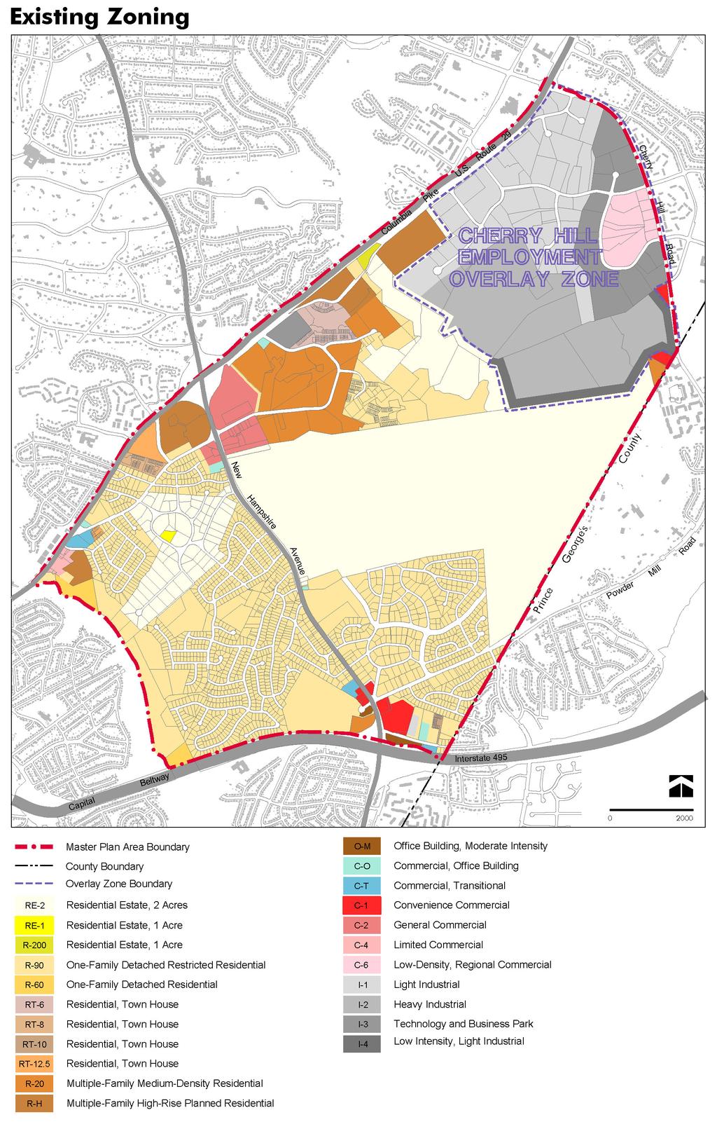
1 MONTGOMERY COUNTY PLANNING DEPARTMENT THE MARYLAND-NATIONAL CAPITAL PARK AND PLANNING COMMISSION MCPB Item No. 10 Date: Zoning Text Amendment (ZTA) No , US 29 Overlay Zone Standards Gregory Russ, Planner Coordinator, FP&P, Mary Dolan, Chief, FP&P, Completed: 06/12/13 Description ZTA No would revise the provisions of the US 29/Cherry Hill Road Employment Area Overlay Zone to allow additional residential and retail uses where the underlying zone is I-1; and establish development standards for the additional uses. Specifically, the ZTA would allow multi-family residential where the underlying base zone is I-1 and the use is part of a mixed-use development that also includes principally commercial or retail commercial uses on the ground floor. The ZTA would also allow a grocery store where the underlying base zone is I-1. Summary Staff recommends approval, with plain language modifications, of ZTA No to allow additional residential and retail uses in the US 29/Cherry Hill Road Employment Area Overlay Zone where the underlying zone is I-1. Background/Analysis The US 29/Cherry Hill Road area (bounded by US 29, Cherry Hill Road, the Federal Research Center, and the Paint Branch stream valley park) has been home to light industrial and service uses, offices, public sector facilities, and heavy industrial. The area was identified as the Montgomery Industrial Park in the 1981 Master Plan for the Eastern Montgomery County Planning Area: Cloverly, Fairland, White Oak, with uses that included the International Fabricare Institute, Contee Sand and Gravel, and the Montgomery County Sludge Composting Facility (the latter two now known respectively as Percontee and Site 2). The 1981 Plan recommended continued industrial land use and zoning in this area. Public policy discourages premature development which would preclude sand and gravel extraction followed by restoration of the mined area for development purposes. This approach looks on mineral resource development as an interim use of land. (page 122) In 1997, Council adopted the US 29 Cherry Hill Employment Area Overlay Zone to implement the recommendations of the 1997 Approved and Adopted Fairland Master Plan. The overlay zone was applied to a 500-acre area with four different industrial classifications including: light (I-1 and I-4); heavy (I-2); and research/development (I-3) zoning. During the 1980s the area developed with light industrial uses and some commercial and service uses such as a hardware store (Home Depot), DarCars auto sales 1
2 and repair and a hotel (Courtyard by Marriott). One hundred acres served as the Site 2 WSSC composting facility (I-2 zone) and 180 acres contained the Percontee gravel washing facility (I-2). The idea of the overlay zone was to be able to provide services for the local residential communities and new development once the FDA relocated, Site II closed and Percontee ended gravel operations. The overlay zone intended to create a self-supporting employment area with on-site services. Commercial uses were to be added in two ways: by rezoning a forty-acre area to allow for large-scale regional retail (C-6 zoning located along Cherry Hill Road between Broadbirch Drive and Plum Orchard Drive) and allowing a smaller amount of commercial retail per underlying zone (50,000 square feet per zone, 15,000 square feet per lot restaurant floor area is in addition to this maximum square footage) to provide for smaller scale goods and services throughout the 500 acre area. Restaurants, but not driveins, were especially desirable because that type of restaurant was lacking in the eastern part of the county, especially near the employment area. In 2005, the overlay zone was amended to allow research, development and related activities where the underlying base zone is I-2 (59-C ). This text change supported the County s interest in utilizing its Site 2 property as a life sciences, education, and research center. The 1997 Overlay Zone (and the 2005 text amendment) was an incremental step in a gradual transition in land use from strictly industrial to a more diverse mix of commercial uses. ZTA No provides for another incremental change in the land uses permitted in this area. Approval of this ZTA will allow property owners that are interested in pursuing plans for a mixed-use residential/retail project to proceed in advance of the Sectional Map Amendment that will implement the proposed zoning recommendations in the draft White Oak Science Gateway Master Plan. The recommendations in the draft Plan represent the next phase of land use planning and set the stage for a transformation of this area. U.S. 29/Cherry Hill Road Employment Area Overlay Zone of the Fairland Master Plan The purpose of this overlay zone is to: (a) Develop a compatible mix of office, regional commercial and light industrial uses within a designated employment area. (b) Establish a uniform set of development standards for the zone. (c) Allow local and regional retail and service uses. (d) Encourage the use of appropriate traffic-limiting measures, where such measures are not already in place, such as car pools and use of mass transit. (e) Eliminate uses not considered compatible with the intent of this overlay zone. ZTA proposes to include an additional purpose to the overlay zone that allows for multi-family residential uses as a part of a mixed-use development in certain situations, in combination with retail uses located on the ground floor. In addition, and as proposed in Subsection (b)(7), Development Standards, at least 65 percent of the FAR of the development must be for multi-family residential use, the building height must be equal to or less than 75 feet and the maximum FAR of the mixed-use building is 1.0 FAR, of which the maximum FAR for residential use is.75 FAR. 2
3 Currently in the overlay zone, development of retail commercial use in the areas not zoned C-6 in the overlay zone cannot exceed 15,000 square feet on any individual lot; and no single tenant, free-standing structure that devotes 50 percent or more of its gross floor area to a retail commercial use may exceed a total of 10,000 gross square feet. The exception to this requirement is limited to an eating and drinking establishment use without a drive-in. ZTA modifies this limitation by also permitting a grocery store to exceed this standard. All of the proposed changes are consistent with the recommendations of the May 2013 Public Hearing Draft of the White Oak Science Gateway Master Plan, as discussed in the Master Plan Update section below. The overlay zone also requires certain trip reduction measures in accordance with Section 59-C Under the I-1 zone, any expansion, redevelopment, etc. of the existing uses that trigger site plan approval and/or preliminary plan approval/amendment will be required to address adequate public facilities requirements at that time. Any retail commercial development in the U.S. 29/Cherry Hill Road Employment Area overlay zone must be approved under the site plan review provisions of Division 59-D- 3, where the cumulative redevelopment exceeds 20 percent of the existing gross floor area. As such, establishment of a new mixed use development will more than likely trigger site plan review, where compatibility issues with adjoining uses would be addressed. Master Plan Update (Attachments 2 & 3) A Master Plan update is underway for the area covered by the US 29/Cherry Hill Road Employment Area Overlay Zone. Planning Board worksessions are scheduled in June and July on the May 2013 Public Hearing Draft of the White Oak Science Gateway Master Plan. The draft Master Plan encourages reinvestment and redevelopment in three activity centers. The largest of these centers is the North White Oak/Cherry Hill Road Center (referred to in the 1997 Plan as the US 29/Cherry Hill Road Employment Area ), which is roughly the same area covered by the Overlay Zone. The draft Plan recommends that this entire area (with the exception of a property recommended for the LSC Zone) be rezoned from I-1, I-2, I-3, and I-4 to several CR zones, which allow mixed-use developments. This recommendation is based on stakeholders interest in seeing the area transform from industrial, office, and service uses to a more diverse mix that includes retail, housing, and additional employment opportunities in technology and, possibly, life sciences. Several properties in this area have recently been purchased by an entity that is interested in redevelopment that is consistent with the vision of the draft Master Plan. One of these sites is the nearly 20-acre block bounded by Industrial Parkway, Tech Road, and Old Columbia Pike that includes a one-story building with leasable flex space and the vacant American Postal Workers Union (APWU) building. The draft Plan specifically references the recent acquisition: This is a highly visible location along US 29, as well as a gateway to this node between two primary roads. Redevelopment of this entire block, including the former APWU building, would be a significant improvement and would complement the Westech Village Corner project, across Tech Road from this site. (page 41) The draft Plan recommends that this block, currently zoned I-1, be rezoned to CR-1.0, C-0.75, R-0.75, H-75 to accommodate redevelopment plans of new owners of these parcels. These areas could redevelop with either all residential or all commercial but are more likely to become mixed-use with residential above retail, which the proposed CR Zone will accommodate. (page 46) 3
4 Conclusion With the proposed changes to the ZTA language as depicted in Attachment 1 (plain language clarifications), staff recommends approval of ZTA Incremental modifications to the overlay zone as established in 1997 have gradually transitioned the area from strictly industrial to a more diverse mix of commercial uses. The inclusion of a residential component appears plausible when considering the development limitations proposed in the ZTA and the recommendations of the May 2013 Public Hearing Draft of the White Oak Science Gateway Master Plan. Attachments 1. ZTA No as modified by staff 2. Area 2 Comments 3. Maps-Existing & Proposed Zoning 4
5 Attachment 3

6 Proposed Zoning
7 ATTACHMENT 1 Zoning Text Amendment No.: Concerning: US 29 Overlay Zone Standards Draft No. & Date: 2 5/7/13 Introduced: May 14, 2013 Public Hearing: Adopted: Effective: Ordinance No.: COUNTY COUNCIL FOR MONTGOMERY COUNTY, MARYLAND SITTING AS THE DISTRICT COUNCIL FOR THAT PORTION OF THE MARYLAND-WASHINGTON REGIONAL DISTRICT WITHIN MONTGOMERY COUNTY, MARYLAND By: Councilmembers Ervin and Floreen AN AMENDMENT to the Montgomery County Zoning Ordinance to revise the provisions of US 29/Cherry Hill Road Employment Area Overlay Zone to: - allow additional residential and retail uses where the underlying zone is I-1; - establish development standards for the additional uses; and - generally amend the text of the zone to make it more concise, precise, and decisive By amending the following sections of the Montgomery County Zoning Ordinance, Chapter 59 of the Montgomery County Code: DIVISION 59-C-18. Section 59-C OVERLAY ZONES. US 29/Cherry Hill Road Employment Area Overlay Zone of the Fairland Master Plan. EXPLANATION: Boldface indicates a Heading or a defined term. Underlining indicates text that is added to existing law by the original text amendment. [Single boldface brackets] indicate text that is deleted from existing law by original text amendment. Double underlining indicates text that is added to the text amendment by amendment. [[Double boldface brackets]] indicate text that is deleted from the text amendment by amendment. * * * indicates existing law unaffected by the text amendment.
8 ORDINANCE The County Council for Montgomery County, Maryland, sitting as the District Council for that portion of the Maryland-Washington Regional District in Montgomery County, Maryland, approves the following ordinance: 2
9 Zoning Text Amendment No.: Sec. 1. DIVISION 59-C-18 is amended as follows: DIVISION 59-C-18. OVERLAY ZONES. * * * Sec. 59-C U.S. 29/Cherry Hill Road Employment Area Overlay Zone of the Fairland Master Plan. 59-C Purpose. The purpose of this overlay zone is to: (a) Develop a compatible mix of office, regional commercial, and light industrial uses within a designated employment area. (b) Establish a uniform set of development standards for the zone. (c) Allow local and regional retail and service uses. (d) Encourage the use of appropriate traffic-limiting measures, where such measures are [not already in place] absent, such as car pools and use of mass transit. (e) Eliminate uses [not considered compatible] incompatible with the intent of this overlay zone. (f) Allow for multi-family residential uses as a part of a mixed-use development in certain situations, in combination with retail uses. 59-C Regulations. (a) Land uses. (1) The following uses are permitted in the U.S. 29/Cherry Hill Road Employment Area overlay zone: (A) All permitted and special exception uses allowed in the underlying zones are allowed in the U.S. 29/Cherry Hill Road Employment Area overlay zone, except as specifically modified [and set forth in] by this overlay zone. 3
10 Zoning Text Amendment No.: * * * * * * (i) The following additional retail commercial uses are permitted: Beauty supply stores. Computer and computer supply stores. Electronics stores. Express or mailing offices. Food and beverage stores. Music stores. Office supply stores. Pet supply stores. Shoe stores. Theaters, indoor. (ii) The following additional commercial uses are permitted: Eating and drinking establishment, excluding a drive-in. Delicatessen. Cafeteria. Snack Bar. Ice Cream Parlor. (iii) The following additional cultural, entertainment or recreational use is permitted: (iv) The following additional manufacturing and industrial, service, and transportation/communication/utility uses are permitted where the underlying base zone is I-2: (v) [[The following additional retail commercial use]] A grocery store is permitted where the underlying base zone is I-1.[[: Grocery store.]] (vi) [[The following additional residential use is permitted, where]] Where the underlying base zone is I-1, multi- 4
11 Zoning Text Amendment No.: family residential uses are permitted under 59-C (b)(7)[[and the use is part of a mixed-use development that also includes principally commercial or retail commercial uses on the ground floor: Multi-family residential]]. (2) The following uses are prohibited in the U.S. 29/Cherry Hill Road Employment Area overlay zone: * * * (b) Development standards. Development will proceed under the standards of the underlying zones, except as modified by the provisions of this overlay zone. (1) Setbacks. (A) Where the overlay zone adjoins, or is separated only by a public road from residentially zoned land that is recommended for residential use and development in the Fairland Master Plan, all buildings must be set back at least 100 feet from such residential land. All parking and maneuvering areas must be set back at least 50 feet from such residential land and be appropriately screened from such adjoining uses. (B) Any building that devotes 50 percent or more of its gross floor area to a retail commercial use must be located at least 200 feet from the boundary of the overlay zone, unless a waiver is granted by the Planning Board. The 200 foot building setback requirement must [not] not be [reduced below] reduced below [[at least]] 150 feet. The parking and maneuvering areas for such a building must be located at least 100 feet from the boundary of the overlay zone. A setback is not required from 5
12 Zoning Text Amendment No.: lot lines, zoning lines, utility rights-of-way or road rights-ofway within this overlay zone. (C) Where the overlay zone adjoins residentially zoned land that adjoins US 29 or a service road that adjoins US 29, and the residentially zoned land is not used or recommended for residential use and development in the Fairland Master Plan, the following setback and screening requirements apply: (i) A setback is not required from the overlay zone boundary; however, notwithstanding the preceding subparagraph (B) above, buildings and parking areas must be setback at least 50 feet from US 29 or a service road that adjoins US 29[,]; and (ii) Screening and landscaping requirements must be established by the Planning Board through site plan review. The parking facility setback and screening requirements of Section 59-E-2.81 and 59-E-2.9 do not apply. (2) Retail commercial area. [[(A)]]Where the underlying base zone is not [[other than the]] C-6 [[Zone]] or is C-6 and develops under Section 59-C (b)(6)(B): [[(i)]](a) the cumulative square footage of retail commercial uses permitted on land classified in each particular base zone within the boundaries of the overlay zone must [not 6
13 Zoning Text Amendment No.: exceed] be equal to or less than a total of 50,000 1 gross square feet; [[and]] [[(ii)]](b) development of retail commercial use cannot exceed 15,000 1 square feet on any individual lot; and [[(iii)]](c) [no] except for a grocery store, a single tenant, free-standing structure that devotes 50 percent or more of its gross floor area to a retail commercial use [may exceed a total of] must be equal to or smaller than 10,000 gross square feet. [[(B) Subsection (A) also applies where the underlying base zone is C-6, and when development occurs [pursuant to] under Section 59-C (b)(6)(B).]] (3) Height limit. A retail building must [not exceed] be equal to or less than 40 feet in height, excluding parapets. (4) Coverage limitation. Where the underlying base zone is other than C-6, the coverage standards for principally retail buildings will be as follows: (A) Green area must encompass at least 35 percent of the lot area. (B) Off-street parking [is not allowed to] must occupy [more than] 45 percent or less of the lot area, except that in unusual circumstances the Planning Board may waive this requirement at the time of site plan approval upon a finding that a more compatible arrangement of uses would result. * * * (6) Retail commercial development. 1 Any square footage devoted: (i) to an eating and drinking establishment use, excluding a drive-in, and (ii) where the underlying base zone is I-1, to a grocery store, is in addition to this amount. 7
14 Zoning Text Amendment No.: (A) Where the underlying base zone is C-6 and the principal use of the C-6 zoned property is a retail commercial use, then the standards of the C-6 Zone will apply[,] and, in addition: (i) [no] a single retail use within a multiple tenant principally retail use structure [may be less than a gross floor area of ] must be at least 10,000 square feet of gross floor area. (ii) [no more than] only one principally retail commercial use [can] may exceed a gross floor area of 100,000 square feet. (B) Where the underlying zone is C-6 and the principal use of the C-6 property is other than retail commercial use, then the standards of the overlay zone will apply. (7) Multi-family residential development. Where a development includes multi-family dwelling units, the following standards must be satisfied: (A) The development must have a mix of uses including a minimum of 65 percent gross floor area for [[that includes commercial or retail commercial]] residential uses. (B) [[At least 65 percent of the FAR of the development must be for residential use, and the]] The ground floor must principally be for commercial or retail commercial uses; however, the ground level may also include: (i) incidental non-commercial uses, such as lobbies, loading areas, and parking access; and (ii) a maximum of 10 percent of the total number of residential units in the building. 8
15 Zoning Text Amendment No.: (C) The building height must be equal to or less than 75 feet, excluding parapets and mechanical equipment. (D) Except as provided in subsection (E), the maximum FAR of the mixed-use building is 1.0 FAR, of which the maximum FAR for residential use is.75 FAR; and (E) The maximum 1.0 FAR and the maximum 0.75 FAR of residential must be increased to accommodate the construction of moderately priced dwelling units and any density bonus authorized under Chapter 25A. (c) Trip reduction guidelines. Within the overlay zone, compliance with the special trip reduction guidelines under Section 59-C-5.436[,] satisfies and represents full compliance with the requirements and[/or] goals for traffic mitigation/management. (d) Site plan. (1) Any retail commercial development in the U.S. 29/Cherry Hill Road Employment Area overlay zone must be approved under the site plan review provisions of Division 59-D-3, except where the cumulative redevelopment [does not exceed] is 20 percent or less of the existing gross floor area. (2) For uses other than retail, site plan review is required only where it is required in the [underlaying] underlying zone. * * * Sec. 2. Effective date. This ordinance becomes effective 20 days after the date of Council adoption. This is a correct copy of Council action
16 Zoning Text Amendment No.: Linda M. Lauer, Clerk of the Council 10
17
18
19
MONTGOMERY COUNTY PLANNING DEPARTMENT
 MONTGOMERY COUNTY PLANNING DEPARTMENT THE MARYLAND-NATIONAL CAPITAL PARK AND PLANNING COMMISSION MCPB Item No. 8 Date: 9-14-17 Zoning Text Amendment No. 17-XX, White Flint 2-Parklawn Overlay Zone Gregory
MONTGOMERY COUNTY PLANNING DEPARTMENT
 MONTGOMERY COUNTY PLANNING DEPARTMENT THE MARYLAND-NATIONAL CAPITAL PARK AND PLANNING COMMISSION MCPB Item No. 4 Date: 2/22/18 (SRA 18-01) Minor Subdivisions Ownership Units Gregory Russ, Planner Coordinator,
MONTGOMERY COUNTY PLANNING DEPARTMENT
 MONTGOMERY COUNTY PLANNING DEPARTMENT THE MARYLAND-NATIONAL CAPITAL PARK AND PLANNING COMMISSION MCPB Item No. 8 Date: 1-10-19 Zoning Text Amendment (ZTA) No. 18-12, Setback Exemption - Fences Gregory
MONTGOMERY COUNTY PLANNING DEPARTMENT
 MONTGOMERY COUNTY PLANNING DEPARTMENT THE MARYLAND-NATIONAL CAPITAL PARK AND PLANNING COMMISSION MCPB Item No. Date: 1-12-17 Zoning Text Amendment (ZTA) No. 16-17, Height Encroachments Townhouses GR PD
MONTGOMERY COUNTY PLANNING DEPARTMENT THE MARYLAND-NATIONAL CAPITAL PARK AND PLANNING COMMISSION
 MONTGOMERY COUNTY PLANNING DEPARTMENT THE MARYLAND-NATIONAL CAPITAL PARK AND PLANNING COMMISSION MCPB Item No. 10 Date: 07-12-12 Zoning Text Amendment (ZTA) No. 12-09, Planned Development (PD) Zones -
MONTGOMERY COUNTY PLANNING DEPARTMENT THE MARYLAND-NATIONAL CAPITAL PARK AND PLANNING COMMISSION
 MONTGOMERY COUNTY PLANNING DEPARTMENT THE MARYLAND-NATIONAL CAPITAL PARK AND PLANNING COMMISSION MCPB Item No. Date: 3-16-17 Rock Spring Master Plan Public Hearing Draft and Draft Zoning Text Amendment
AN AMENDMENT to the Montgomery County Zoning Ordinance to: - establish the Montgomery Village Overlay Zone. Development Standards for Euclidean Zones
 Concerning: New Overlay Zone Montgomery Village Draft No. & Date: 1-7/23/15 Introduced: Public Hearing: Adopted: Effective: Ordinance No.: COUNTY COUNCIL FOR MONTGOMERY COUNTY, MARYLAND SITTING AS THE
MONTGOMERY COUNTY PLANNING DEPARTMENT THE MARYLAND-NATIONAL CAPITAL PARK AND PLANNING COMMISSION
 MONTGOMERY COUNTY PLANNING DEPARTMENT THE MARYLAND-NATIONAL CAPITAL PARK AND PLANNING COMMISSION MCPB Item Nos. 11 & 12 Subdivision Regulation Amendment (SRA) No. 14-01, Platting Exceptions Rural Village
MONTGOMERY COUNTY PLANNING DEPARTMENT THE MARYLAND-NATIONAL CAPITAL PARK AND PLANNING COMMISSION
 MONTGOMERY COUNTY PLANNING DEPARTMENT THE MARYLAND-NATIONAL CAPITAL PARK AND PLANNING COMMISSION MCPB Item No. Date: 4-30-15 Zoning Text Amendment (ZTA) No. 15-06, Rural Cluster Zone - Land Use and Setbacks
MONTGOMERY COUNTY PLANNING DEPARTMENT THE MARYLAND-NATIONAL CAPITAL PARK AND PLANNING COMMISSION
 MONTGOMERY COUNTY PLANNING DEPARTMENT THE MARYLAND-NATIONAL CAPITAL PARK AND PLANNING COMMISSION MCPB Item No. 9 Date: 06-21-12 Proposed Zoning Text Amendment Revising the Requirements for Permitting Accessory
MONTGOMERY COUNTY PLANNING DEPARTMENT THE MARYLAND-NATIONAL CAPITAL PARK AND PLANNING COMMISSION
 MONTGOMERY COUNTY PLANNING DEPARTMENT THE MARYLAND-NATIONAL CAPITAL PARK AND PLANNING COMMISSION MCPB Item No. 3 Date: 05-03-12 Proposed Zoning Text Amendment Revising the Requirements for permitting Accessory
Action MEMORANDUM. Jeffrey L. Zyon~enior Legislative Analyst
 AGENDA ITEM #7D February 6, 2018 Action MEMORANDUM February 2, 2018 TO: FROM: County Council Y Jeffrey L. Zyon~enior Legislative Analyst SUBJECT: Action: ZTA 17-13, Exemptions - Public Taking PHED Recommendation:
MONTGOMERY COUNTY PLANNING DEPARTMENT THE MARYLAND-NATIONAL CAPITAL PARK AND PLANNING COMMISSION
 MONTGOMERY COUNTY PLANNING DEPARTMENT THE MARYLAND-NATIONAL CAPITAL PARK AND PLANNING COMMISSION MCPB Consent Item Date: 11-2-17 Washington Adventist Hospital, Site Plan Amendment No. 82008021F Rhoda Hersson-Ringskog,
MONTGOMERY COUNTY PLANNING DEPARTMENT
 MONTGOMERY COUNTY PLANNING DEPARTMENT THE MARYLAND-NATIONAL CAPITAL PARK AND PLANNING COMMISSION MCPB Item No. 9 Date: 9/7/17 (SRA 17-01) Approval Procedures Burial sites; Bill 24-17 Land Use Information
MEMORANDUM. Action - Zoning Text Amendment 15-12, Overlay Zone - Montgomery Village
 Agenda Item #5B February 9, 2016 Action MEMORANDUM February 5, 2016 TO: FROM: SUBJECT: County Council (j jr Jeffrey L. Zyon lenior Legislative Analyst Action - Zoning Text Amendment 15-12, Overlay Zone
Attachment 4 ANALYSIS I. Current Special Exception Use Standards for Accessory Apartments (Also See Attachment 2 Table for Quick Comparison)
") The Planning Board conducted the first of its public hearings/worksessions on the proposed accessory apartment provisions on May 3, 2012. At that time, the Board determined that additional input from stakeholders
The Planning Board conducted the first of its public hearings/worksessions on the proposed accessory apartment provisions on May 3, 2012. At that time, the Board determined that additional input from stakeholders
MEMORANDUM. Action-Revised Zoning Text Amendment 16-20, Overlay Zone -Bethesda
 AGENDA ITEM #7 July 11, 2017 Action MEMORANDUM TO: FROM: County Council A/' Jeffrey L. Zyontz, {enior Legislative Analyst July 7, 2017 SUBJECT: Action-Revised Zoning Text Amendment 16-20, Overlay Zone
Master Plan Review SILVER SPRING CBD. Approved and Adopted February Updated January 2013
 Master Plan Review SILVER SPRING CBD Approved and Adopted February 2000 BACKGROUND ZONING CODE REWRITE In 2007, the Montgomery County Council directed the Planning Department to undertake a comprehensive
PC Staff Report 11/18/2013 Z Item No. 1-1
 Z-13-00401 Item No. 1-1 PLANNING COMMISSION REPORT Regular Agenda - Public Hearing Item PC Staff Report 11/18/2013 ITEM NO. 1: Z-13-00401 IG (General Industrial) District TO CS (Strip Commercial) District;
Division 59-C-10. RMX Zones-Residential Mixed Use Development. [Note]
![Division 59-C-10. RMX Zones-Residential Mixed Use Development. [Note]](/thumbs/78/77243902.jpg "Division 59-C-10. RMX Zones-Residential Mixed Use Development. [Note]") Key Text highlighted in bright green deals with floating zones and will be addressed in the coming months. Text highlighted in turquoise deals with grandfathering language and will be addressed in the
Key Text highlighted in bright green deals with floating zones and will be addressed in the coming months. Text highlighted in turquoise deals with grandfathering language and will be addressed in the
By: District Council at Request of the Planning Board. AN AMENDMENT to the Montgomery County Zoning Ordinance to:
 Zoning Text Amendment No: 08-14 Concerning: Transit Mixed-Use (TMX) Zone- Establishment Draft No. & Date: 2-6/23/08 Introduced: ublic Hearing: Adopted: Effective: Ordinance No: COUNTY COUNCIL FOR MONTGOMERY
MONTGOMERY COUNTY PLANNING DEPARTMENT THE MARYLAND-NATIONAL CAPITAL PARK AND PLANNING COMMISSION
 MONTGOMERY COUNTY PLANNING DEPARTMENT THE MARYLAND-NATIONAL CAPITAL PARK AND PLANNING COMMISSION MCPB Item No. Date: 5/11/17 (ZTA 16-03) Bed & Breakfast Standards & Accessory Residential Uses Tenancy Duration
ARTICLE 3 ZONING DISTRICTS AND ZONING MAP. Table of Contents
 ARTICLE 3 ZONING DISTRICTS AND ZONING MAP Table of Contents 3-1 Establishment of Zoning Districts... 1 A. General Use Zoning Districts... 1 B. Conditional Zoning Districts... 3 C. Overlay Zoning Districts...
4 LAND USE 4.1 OBJECTIVES
 4 LAND USE The Land Use Element of the Specific Plan establishes objectives, policies, and standards for the distribution, location and extent of land uses to be permitted in the Central Larkspur Specific
MEMORANDUM. Action - Revised Zoning Text Amendment 16-20, Overlay Zone - Bethesda
 AGENDA ITEM #4B July 18, 2017 Action MEMORANDUM July 11, 2017 TO: FROM: SUBJECT: County Council flj- Jeffrey L. Zyont&enior Legislative Analyst Action - Revised Zoning Text Amendment 16-20, Overlay Zone
ORDINANCE NO
 Item 4 Attachment A ORDINANCE NO. 2017-346 AN ORDINANCE OF THE CITY COUNCIL OF THE CITY OF CALABASAS, CALIFORNIA AMENDING CHAPTER 17.22 OF THE CALABASAS MUNICIPAL CODE, AFFORDABLE HOUSING, TO BRING INTO
ARTICLE VII. NONCONFORMITIES. Section 700. Purpose.
 ARTICLE VII. NONCONFORMITIES. Section 700. Purpose. The purpose of this chapter is to regulate and limit the development and continued existence of legal uses, structures, lots, and signs established either
Master Plan Review POTOMAC. Approved and Adopted March Updated January 2013
 Master Plan Review POTOMAC Approved and Adopted March 2002 BACKGROUND ZONING CODE REWRITE In 2007, the Montgomery County Council directed the Planning Department to undertake a comprehensive zoning ordinance
Indicates Council-recommended changes Introduced by: Mr. Tackett Date of introduction: June 14, 2016 SUBSTITUTE NO. 1 TO ORDINANCE NO.
 Indicates Council-recommended changes Introduced by: Mr. Tackett Date of introduction: June 14, 2016 SUBSTITUTE NO. 1 TO ORDINANCE NO. 16-067 TO AMEND NEW CASTLE COUNTY CODE CHAPTER 40 (ALSO KNOWN AS THE
Article Optional Method Requirements
 Article 59-6. Optional Method Requirements [DIV. 6.1. MPDU DEVELOPMENT IN RURAL RESIDENTIAL AND RESIDENTIAL ZONES Sec. 6.1.1. General Requirements... 6 2 Sec. 6.1.2. General Site and Building Type Mix...
PLANNING & ZONING DEPARTMENT Town Hall Annex, 66 Prospect St., Ridgefield, CT Fax
 PLANNING & ZONING DEPARTMENT Town Hall Annex, 66 Prospect St., Ridgefield, CT 06877 203-431-2766 Fax 203-431-2737 ADOPTED AMENDMENT TO THE ZONING REGULATIONS NEW Section 5.6 Neighborhood Business Zone
SHOPPING CENTER DISTRICT (Zone BSC)
") Sec. 3-27. SHOPPING CENTER DISTRICT (Zone BSC) (a) (b) Area. All land designated as Zone BSC is subject to the regulations of this Section and Sec. 20.3-10. Such areas are established to provide for planned
Sec. 3-27. SHOPPING CENTER DISTRICT (Zone BSC) (a) (b) Area. All land designated as Zone BSC is subject to the regulations of this Section and Sec. 20.3-10. Such areas are established to provide for planned
Implementation. Approved Master Plan and SMA for Henson Creek-South Potomac 103
 Implementation Approved Master Plan and SMA for Henson Creek-South Potomac 103 104 Approved Master Plan and SMA for Henson Creek-South Potomac Sectional Map Amendment The land use recommendations in the
ZONING ORDINANCE: OPEN SPACE COMMUNITY. Hamburg Township, MI
 ZONING ORDINANCE: OPEN SPACE COMMUNITY Hamburg Township, MI ARTICLE 14.00 OPEN SPACE COMMUNITY (Adopted 1/16/92) Section 14.1. Intent It is the intent of this Article to offer an alternative to traditional
13 Sectional Map Amendment
 13 Sectional Map Amendment Introduction This chapter reviews land use and zoning policies and practices in Prince George s County and presents the proposed zoning in the sectional map amendment (SMA) to
MEMORANDUM. Agenda Item 9A July 17, 2018 Introduction. July 13, 2018 TO: County Council FROM: Jeffry L. Zyon/ Lor Legislative Analyst
 Agenda Item 9A July 17, 2018 Introduction MEMORANDUM July 13, 2018 TO: FROM: County Council Jeffry L. Zyon/ Lor Legislative Analyst SUBJECT: Introduction: Bill 26-18, Landlord-Tenant Relations - Accessory
Master Plan Review WESTBARD
 Master Plan Review WESTBARD Approved and Adopted 1982 Westbard Page 1 of 15 Updated July 2014 based on Adopted DMA ONING CODE REWRITE BACKGROUND In 2007, the Montgomery County Council directed the Planning
Use of the Zoning Ordinance
 Use of the Zoning Ordinance 1. Coordination with Other Chapters A. The use of structures and land within Montgomery County must satisfy all other applicable provisions as well as this Chapter, whether
Midwest City, Oklahoma Zoning Ordinance
 2010 Midwest City, Oklahoma Zoning Ordinance 9/2/2010 Table of Contents Section 1. General Provisions... 5 1.1. Citation... 5 1.2. Authority... 5 1.3. Purpose... 5 1.4. Nature and Application... 5 1.5.
ORDINANCE NO. 15,060
 ORDINANCE NO. 15,060 AN ORDINANCE to amend the Municipal Code of the City of Des Moines, Iowa, 2000, adopted by Ordinance No. 13,827, passed June 5, 2000, as heretofore amended, is hereby amended by adding
NOTICE OF MEETING AND AGENDA FOR THE PLANNING COMMISSION OF SPRINGVILLE, UTAH... JANUARY 23, 2018
 NOTICE OF MEETING AND AGENDA FOR THE PLANNING COMMISSION OF SPRINGVILLE, UTAH............................ JANUARY 23, 2018 Notice is hereby given that the Planning Commission will hold a public meeting
ARTICLE 15 - PLANNED UNIT DEVELOPMENT
 Section 15.1 - Intent. ARTICLE 15 - PLANNED UNIT DEVELOPMENT A PUD, or Planned Unit Development, is not a District per se, but rather a set of standards that may be applied to a development type. The Planned
ARTICLE C. ZONING TEXT, DISTRICT CLASSIFICATIONS AND BOUNDARIES
 ARTICLE C. ZONING TEXT, DISTRICT CLASSIFICATIONS AND BOUNDARIES Sec. 10-2054. ZONING TEXT, DISTRICT CLASSIFICATIONS AND BOUNDARIES. In order to regulate the location of structures, the height and bulk
RESOLUTION NO. PC
 RESOLUTION NO. PC 17-1235 A RESOLUTION OF THE PLANNING COMMISSION OF THE CITY OF WEST HOLLYWOOD, RECOMMENDING TO THE CITY COUNCIL APPROVAL OF A ZONE TET AMENDMENT AMENDING PORTIONS OF TITLE 19, WEST HOLLYWOOD
Chapter 59 Montgomery county zoning ordinance planning board draft
 Chapter 59 Montgomery county zoning ordinance planning board draft Use of the Zoning Ordinance 1. Coordination with Other Chapters A. The use of structures and land within Montgomery County must satisfy
Sec Tier 2 principal uses and structures. The principal uses of land and structures allowed in Tier 2 are provided below subject to the
 Sec. 27-730.4.9. Tier 2 principal uses and structures. The principal uses of land and structures allowed in Tier 2 are provided below subject to the standards and limitations contained within this division.
Town of Cumberland Town Council Neighborhood Meeting Notice Monday, December 12, 2016 at 5:30 P.M. Town Council Chambers
 Town of Cumberland Town Council Neighborhood Meeting Notice Monday, December 12, 2016 at 5:30 P.M. Town Council Chambers The Cumberland Town Council invites you to a neighborhood meeting on Monday, December
Charter Township of Plymouth Zoning Ordinance No. 99 Page 65 Article 12: C-1 Neighborhood Shopping District
 Charter Township of Plymouth Zoning Ordinance No. 99 Page 65 PURPOSE ARTICLE XII C-1 NEIGHBORHOOD SHOPPING DISTRICT To provide for neighborhood shopping facilities in close proximity to residential areas
Staff recommends the City Council hold a public hearing, listen to all pertinent testimony, and introduce on first reading:
 CITY COUNCIL PUBLIC HEARING JANUARY 16, 2018 SUBJECT: INITIATED BY: MULTI-FAMILY NEIGHBORHOODS ZONE TEXT AMENDMENTS: AMEND MINIMUM DENSITY REQUIREMENTS FOR R3 AND R4 DISTRICTS; AMEND THE DENSITY BONUS
Barbara County Housing Element. Table 5.1 Proposed Draft Housing Element Goals, Policies and Programs
 Table 5.1 Proposed Draft Housing Element Goals, Policies and Programs Goal 1: Enhance the Diversity, Quantity, and Quality of the Housing Supply Policy 1.1: Promote new housing opportunities adjacent to
ORDINANCE NO. AN ORDINANCE OF THE CITY COUNCIL OF THE CITY OF DALY CITY REPEALING AND REPLACING CHAPTER RE: INCLUSIONARY HOUSING
 ORDINANCE NO. AN ORDINANCE OF THE CITY COUNCIL OF THE CITY OF DALY CITY REPEALING AND REPLACING CHAPTER 17.47 RE: INCLUSIONARY HOUSING The City Council of the City of Daly City, DOES ORDAIN as follows:
Appendix A: Guide to Zoning Categories Prince George's County, Maryland
 Appendix A: Guide to Zoning Categories Prince George's County, Maryland RESIDENTIAL ZONES 1 Updated November 2010 R-O-S: Reserved Open Space - Provides for permanent maintenance of certain areas of land
17.0 NONCONFORMITIES CHAPTER 17: NONCONFORMITIES Purpose and Applicability
 17.0 NONCONFORMITIES 17.1 Purpose and Applicability The purpose of this section is to regulate and limit the continued existence of uses and structures established prior to the effective date of this Ordinance
PENDING BUSINESS LEGISLATION
 Page 1 of 13 Volume 1, Issue 4 Montgomery County s Business Law Firm Questions: For questions, to testify, or to meet with Councilmembers about proposed legislation, please call or email your attorney
CHAPTER Committee Substitute for House Bill No. 7065
 CHAPTER 2013-59 Committee Substitute for House Bill No. 7065 An act relating to Everglades improvement and management; amending s. 373.4592, F.S.; revising legislative findings for achieving water quality
Salem Township Zoning Ordinance Page 50-1 ARTICLE 50.0: PUD PLANNED UNIT DEVELOPMENT
 Salem Township Zoning Ordinance Page 50-1 ARTICLE 50.0 PLANNED UNIT DEVELOPMENT Section 50.01 Purpose The provisions of this Article provide enabling authority and standards for the submission, review,
MONTGOMERY COUNTY PLANNING DEPARTMENT THE MARYLAND-NATIONAL CAPITAL PARK AND PLANNING COMMISSION
 MONTGOMERY COUNTY PLANNING DEPARTMENT THE MARYLAND-NATIONAL CAPITAL PARK AND PLANNING COMMISSION MCPB Item No.: Date: 11-12-15 15931 Frederick Road (CarMax) Annexation Request ANX2015-00145 Patrick Butler,
MPDU Law Update 9/10/2018 1
 Montgomery Planning 9/10/2018 MPDU Law Update MPDU Law Update 9/10/2018 1 Lisa Govoni, Housing Planner lisa.govoni@montgomeryplanning.org (301) 650-5624 Background Bill 34 17 Introduced 10/31/17 Bill 38-17
Chapter 9.10 Downtown Districts
 Division 2: Base and Overlay Districts Chapter 9.10 Downtown Districts 9.10.001 Incorporation of Downtown Community lan Standards and Development standards and land use designations, for the Downtown Community
MEMORANDUM. DATE: November 9, 2016 PC Agenda Item 3.B. Planning Commission Chair Thompson and Commissioners
 MEMORANDUM DATE: November 9, 2016 PC Agenda Item 3.B TO: FROM: SUBJECT: Planning Commission Chair Thompson and Commissioners Matthew Bachler, Senior Planner Planning Case #16-028 Public Hearing Required
Regular Meeting and Public Hearing of the Zoning Subcommittee
 Regular Meeting and Public Hearing of the Zoning Subcommittee Tuesday, September 05, 2017 7:00 PM Council Chambers, City Hall, 2nd Floor, 27 West Main Street, New Britain, Connecticut NOTICE - The Common
Article 11.0 Nonconformities
 Sec. 11.1 Generally The purpose of this Article is to establish regulations and limitations on the continued existence of uses, lots, structures, signs, parking areas and other development features that
Be linked by an internal circulation system (i.e., walkways, streets, etc.) to other structures within the IPUD;
 to other structures within the IPUD;") 2. HALIFAX ACTIVITY CENTER A. DESCRIPTIONS OF FUTURE LAND USE DESIGNATIONS Each of the future land use designations specified by Phase I of the Halifax Activity Center Plan, and the relationship of these
2. HALIFAX ACTIVITY CENTER A. DESCRIPTIONS OF FUTURE LAND USE DESIGNATIONS Each of the future land use designations specified by Phase I of the Halifax Activity Center Plan, and the relationship of these
MEMORANDUM. City Council. David J. Deutsch, City Manager. County Zoning Ordinance Rewrite Briefing. DATE: June 11, 2015
 MEMORANDUM TO: FROM: SUBJECT: City Council David J. Deutsch, City Manager County Zoning Ordinance Rewrite Briefing DATE: June 11, 2015 As Council is aware, Prince George's County is conducting a comprehensive
ADUs and You! Common types of ADUs include mother-in-law suite, garage apartments and finished basements.
 ADUs and You! Accessory Dwelling Units Town of Lyons Accessory Dwelling Units (ADUs) are a form of housing that can be an important tool for diversifying and increasing the local housing stock. Lyons lost
City of Falls Church
 1 Meeting Date: 05-07-18 Proposed Motion: None. City of Falls Church Title: (TO18-01) ORDINANCE TO AMEND ARTICLE IV, DIVISION 10, B-2 CENTRAL BUSINESS DISTRICT, OF THE ZONING ORDINANCE TO AMEND SEC. 48-486.
PLANNED UNIT DEVELOPMENT & SUBDIVISION STAFF REPORT Date: April 18, 2019
 PLANNED UNIT DEVELOPMENT & SUBDIVISION STAFF REPORT Date: April 18, 2019 DEVELOPMENT NAME SUBDIVISION NAME Springhill Village Subdivision Springhill Village Subdivision LOCATION 4350, 4354, 4356, 4358,
CHAPTER 40R LOCAL ZONING BYLAW GUIDANCE DOCUMENT
 CHAPTER 40R LOCAL ZONING BYLAW GUIDANCE DOCUMENT OVERVIEW This document has been developed by the Department of Housing and Community Development (DHCD, or the Department) to assist communities in drafting
PHED DRAFT Zoning Translation
 Symbol Name Symbol Name Agricultural & Rural RDT Rural Density Transfer AR Agricultural Reserve R Rural R Rural RC Rural Cluster RC Rural Cluster LDRC Low Density Rural Cluster No area zoned LDRC. Zone
Denver Zoning Code Amendment General Development Plan Revisions REDLINE PUBLIC REVIEW DRAFT 1/16/19
 Denver Zoning Code Amendment General Development Plan Revisions REDLINE PUBLIC REVIEW DRAFT 1/16/19 This document contains the redlined draft of a proposed text amendment and rules and regulations to revamp
Wheaton Sector Plan. Preliminary. Recommendations. Montgomery County Planning Board
 Sector Plan Preliminary Recommendations Montgomery County Planning Board 12-03-09 Scope of Work September 2008 Status Report June 2009 Preliminary Recommendations December 2009 1952 Process Today Community
City-Initiated Study for the West Side of Roncesvalles Avenue, Between Marmaduke Street and Marion Street Final Report
 STAFF REPORT ACTION REQUIRED City-Initiated Study for the West Side of Roncesvalles Avenue, Between Marmaduke Street and Marion Street Final Report Date: November 22, 2013 To: From: Wards: Reference Number:
7. IMPLEMENTATION STRATEGIES
 7. IMPLEMENTATION STRATEGIES A. GENERAL APPROACH FOR IMPLEMENTATION Implementing the plan will engage many players, including the Municipality of Anchorage (MOA), the Government Hill Community Council,
Provide a diversity of housing types, responsive to household size, income and age needs.
 8 The City of San Mateo is a highly desirable place to live. Housing costs are comparably high. For these reasons, there is a strong and growing need for affordable housing. This chapter addresses the
Oak Cliff Gateway District PD 468
 Oak Cliff Gateway District PD 468 August 21, 2014 2013 Authorized Hearing Authorized Hearing September, 2013 September 12, 2013 City Plan Commission expanded boundaries to represent current Oak Cliff Gateway
Presentation. Agenda Item # 1. Meeting Date February 3, Erkin Ozberk, Planner. Prepared By. Brian T. Kenner City Manager.
 Agenda Item # 1 Presentation Meeting Date February 3, 2014 Prepared By Approved By Erkin Ozberk, Planner Brian T. Kenner City Manager Discussion Item Background Update on Montgomery County s Zoning Code
ARTICLE III Section BUSINESS A GENERAL BUSINESS DISTRICT
 ARTICLE III Section 3-110 BUSINESS A GENERAL BUSINESS DISTRICT Section 3-110.1 - Intent General Business Districts provide for the appropriate development and special requirements for the major business
Office Space Offered for Sale
 Office Space Offered for Sale Oland Professional Center Condominium 3402 Olandwood Court, Olney, Maryland 20832 Montgomery County Overview The offering is for the sale of one office space consisting of
Article Zones and Zoning Map
 Division 2.1. Zones Established Council Draft Article 59-2. Zones and Zoning Map Section 2.1.1. Requirements for All Zones A. Zones established in Article 59-2 must satisfy: 1. Definitions under Article
THE PEOPLE OF THE CITY OF LOS ANGELES DO ORDAIN AS FOLLOWS:
 ORDINANCE NO..1_, 8_'2_{_19_5 An ordinance amending Sections 11.01, 12.03, 12.24, 12.28, 13.03, 14.3.1, and 16.05 of the Los Angeles Municipal Code to update common findings for conditional uses, adjustments,
IFRS 16 LEASES. Page 1 of 21
 IFRS 16 LEASES OBJECTIVE The objective is to ensure that lessees and lessors provide relevant information in a manner that faithfully represents those transactions. This information gives a basis for users
CHAPTER 50 LAND USE ZONES ARTICLE 50 BASIC PROVISIONS
 CHAPTER 50 LAND USE ZONES ARTICLE 50 BASIC PROVISIONS 50.010 - PURPOSE The purposes of this chapter are to establish land use zones required to implement the goals and policies of the Klamath County Comprehensive
(1) At least ten percent of the total units are designated for low income households.
 At least ten percent of the total units are designated for low income households.") SAN MATEO MUNICIPAL CODE 27.16.060 DENSITY BONUS. (a) Purpose. The purpose of this section is to comply with the state density bonus law (California Government Code section 65915) and to implement the
SAN MATEO MUNICIPAL CODE 27.16.060 DENSITY BONUS. (a) Purpose. The purpose of this section is to comply with the state density bonus law (California Government Code section 65915) and to implement the
Oceanside Zoning Ordinance
 Oceanside Zoning Ordinance 3006 Accessory Dwelling Units (1992 and Redevelopment Zoning Ordinance) Amendments Article 42 Accessory Dwelling Units (1986 Zoning Ordinance) New [Strike-thru = Deleted language,
File Reference No Re: Proposed Accounting Standards Update, Leases (Topic 842): Targeted Improvements
: Targeted Improvements") Deloitte & Touche LLP 695 East Main Street Stamford, CT 06901-2141 Tel: + 1 203 708 4000 Fax: + 1 203 708 4797 www.deloitte.com Ms. Susan M. Cosper Technical Director Financial Accounting Standards Board
Deloitte & Touche LLP 695 East Main Street Stamford, CT 06901-2141 Tel: + 1 203 708 4000 Fax: + 1 203 708 4797 www.deloitte.com Ms. Susan M. Cosper Technical Director Financial Accounting Standards Board
Generic Environmental Impact Statement. Build-Out Analysis. City of Buffalo, New York. Prepared by:
 Generic Environmental Impact Statement Build-Out Analysis City of Buffalo, New York 2015 Prepared by: TABLE OF CONTENTS 1.0 INTRODUCTION 1 2.0 METHODOLOGY 2 3.0 EXISTING LAND USE 3 4.0 EXISTING ZONING
ARTICLE III Section COMMERCIAL OFFICE RETAIL ENTERPRISE DISTRICT
 ARTICLE III Section 3-100 COMMERCIAL OFFICE RETAIL ENTERPRISE DISTRICT Section 3-100.1 Intent. The CORE district is intended to accommodate high intensity business uses appropriate for downtown locations
CHAPTER COMMERCIAL AND INDUSTRIAL ZONING DISTRICTS
 Commercial and Industrial Zoning Districts 106.26.010 CHAPTER 106.26 - COMMERCIAL AND INDUSTRIAL ZONING DISTRICTS COMMERCIAL AND INDUSTRIAL ZONING DISTRICTS Sections: 106.26.010 - Purpose 106.26.020 -
Operating Standards Attachment to Development Application
 Planning & Development Services 2255 W Berry Ave. Littleton, CO 80120 Phone: 303-795-3748 Mon-Fri: 8am-5pm www.littletongov.org Operating Standards Attachment to Development Application 1 PLANNED DEVELOPMENT
Article Zones and Zoning Map
 Article 59-2. Zones and Zoning Map [Div. 2.1. Zones Established Sec. 2.1.1. Requirements for all Zones... 2 2 Sec. 2.1.2. Zoning Categories...2 2 Sec. 2.1.3. Agricultural Zone...2 2 Sec. 2.1.4. Rural Residential
MONTGOMERY COUNTY PLANNING DEPARTMENT THE MARYLAND-NATIONAL CAPITAL PARK AND PLANNING COMMISSION
 MONTGOMERY COUNTY PLANNING DEPARTMENT THE MARYLAND-NATIONAL CAPITAL PARK AND PLANNING COMMISSION MCPB Item No. Date: 9/22/11 Site Plan Amendment 82008011A, North Bethesda Center Parcels F, I, & J Joshua
CHAPTER 21.04: ZONING DISTRICTS
 CHAPTER 21.04: ZONING DISTRICTS 21.04.010 GENERAL PROVISIONS... 4-3 A. Districts Established; Zoning Map... 4-3 B. Relationship to Overlay Districts... 4-4 21.04.020 RESIDENTIAL DISTRICTS... 4-4 A. General
Jcouncilmembers should bring their copy of the Plan to the meeting.i. PHED Committee #lb October 30, 2017 MEMORANDUM. October 26, 2017 TO:
 PHED Committee #lb October 30, 2017 MEMORANDUM October 26, 2017 TO: FROM: Planning, Housing, and Economic Development (PHED) Committee Marlene Michaelso1ltnior Legislative Analyst SUBJECT: White Flint
CITY PLAN COMMISSION STAFF REPORT
 CITY PLAN COMMISSION STAFF REPORT SUBJECT: Request for a Change of Zoning and Preliminary Development Plan FROM: Mara Perry, Director of Planning & Development MEETING DATE: November 6, 2017 PETITION:
PLANNING COMMISSION STAFF REPORT
 PLANNING COMMISSION STAFF REPORT West Capitol Hill Zoning Map Amendment Petition No. PLNPCM2011-00665 Located approximately at 548 W 300 North Street, 543 W 400 North Street, and 375 N 500 West Street
Planning Board Worksession No.4: Parklawn South District and Randolph Hills District
 Planning Board Worksession No.4: Parklawn South District and Randolph Hills District Prior Worksessions January 27: Focused on transportation analysis and staging recommendations in the Draft Plan. February
Campus Sector Animal hospital SE N P (for properties abutting Adams and Van Buren Avenues) Antique shops N P N Appliance sales/ service
 Antique shops N P N Appliance sales/ service") 143-136. Use Regulations for. [Amended 7-20-2000 by Ord. o. 448; 2-15-2001 by Ord. o. 453; 9-21-2006 by Ord. o. 556; 12-3-2009 by Ord. o. 586] A. In the, and in the and s, land, buildings or premises shall
143-136. Use Regulations for. [Amended 7-20-2000 by Ord. o. 448; 2-15-2001 by Ord. o. 453; 9-21-2006 by Ord. o. 556; 12-3-2009 by Ord. o. 586] A. In the, and in the and s, land, buildings or premises shall
RAE EXCLUSIVE RESIDENTIAL ZONE A residential district exclusively for low density single family housing and accessory uses.
 KNOX COUNTY ZONING ORDINANCE DISTRICT SUMMARY REQUIREMENTS 2/11/2009 RAE EXCLUSIVE RESIDENTIAL ZONE A residential district exclusively for low density single family housing and accessory uses. 10,000 sq.
COMMERCIAL/INDUSTRIAL DEVELOPMENT GUIDELINES
 COMMERCIAL/INDUSTRIAL DEVELOPMENT GUIDELINES Planning Division Sections Chapter 17.16 Commercial, Industrial Development Standards 17.16.010 Lot Size 17.16.020 Setbacks 17.16.030 Fences, Hedges and Walls
STATE OF CALIFORNIA AUTHENTICATED ELECTRONIC LEGAL MATERIAL. State of California GOVERNMENT CODE. Section 65915
 STATE OF CALIFORNIA AUTHENTICATED ELECTRONIC LEGAL MATERIAL State of California GOVERNMENT CODE Section 65915 65915. (a) When an applicant seeks a density bonus for a housing development within, or for