Master Plan Review SILVER SPRING CBD. Approved and Adopted February Updated January 2013
|
|
|
- Toby Howard
- 5 years ago
- Views:
Transcription
1 Master Plan Review SILVER SPRING CBD Approved and Adopted February 2000

2 BACKGROUND ZONING CODE REWRITE In 2007, the Montgomery County Council directed the Planning Department to undertake a comprehensive zoning ordinance rewrite. Last rewritten in 1977, the current 1,200 + page code is viewed as antiquated and hard to use with standards that have failed to keep pace with modern development practices. With only about four percent of land in the County available for greenfield development, the new zoning code can play a crucial role in guiding redevelopment to areas like surface parking lots and strip shopping centers. An updated zoning code is important for achieving the kind of growth Montgomery County policymakers and residents want. Initial sections of the new code were drafted by Code Studio, a zoning consultant. These drafts were subsequently analyzed and edited by planners based on feedback from the Zoning Advisory Panel (a citizen panel appointed by the Planning Board to weigh in on the project s direction), county agency representatives, residents and other stakeholders. In September 2012, planning staff began the release of a draft code in sections accompanied by a report highlighting changes from the current code. The staff drafts were reviewed at length by the Planning Board. After several public sessions and many worksessions, the Board is nearing the end of its review. After additional worksessions in February to consider definitions, parking and other outstanding issues, the Board will undertake an implementation review, where they will evaluate and make recommendations on potential zone changes. Later this spring, following the completion of the text and implementation review, a Planning Board Draft will be sent to County Council for consideration. ZONE IMPLEMENTATION PROCESS An important aspect of the Zoning Rewrite process is the potential simplification of 123 existing zones into about 30 proposed zones. While some of the proposed zones are a direct one-to-one translation of existing zones, others are the result of combining existing zones with similar standards. Additionally, existing zones that are not currently mapped or are no longer used in the County have been eliminated from the proposed code. Through the implementation process, Montgomery County aims to simplify the number of zones, eliminate redundancy, and clarify development standards. A full translation table for all zones can be found in the documents section of our website:.
3 Agricultural, Residential, and Industrial Zone Implementation: For agricultural and rural zones, the existing zones will be translated to proposed zones on a one-toone basis, with the exception of the Low Density Rural Cluster zone which is not currently used in the County and will be eliminated. Many of the existing residential zones will remain the same. Other residential zones will be combined with existing zones that have similar development standards. The R-4Plex zone, which is not currently mapped anywhere in the county, will be removed from the proposed code. Implementation of Industrial zones will combine similar zones (Rural Service, I-1, and R+D) into the proposed Industrial Moderate (IM) zone. The existing heavy industrial zone (I-2) will be renamed as the Industrial Heavy (IH) zone. Examples: Agricultural and Rural Rural Density Transfer (RDT) Agricultural Reserve (AR) Residential R-60 (detached residential) R-60/TDR (detached residential) R-60 (detached residential)
4 Commercial and Mixed-Use Zone Implementation: Parcels located in the existing Commercial, Mixed-use, Central Business District (CBD), and Transit Station zones will be translated into one of the proposed Commercial/Residential (CR) or Employment (E) Zones using a two-tiered process. First, decisions about specific parcels in these zones were based on recommendations within the Master Plan. Planning staff reviewed each Master Plan in the County. When the Master Plan provided specific recommendations about allowed density, height, or mix of uses for individual commercial or mixed-use parcels, those recommendations were used to build the formula of the proposed zone. This ensures consistency with currently allowed density and height, and helps codify Master Plan recommendations in a parcel-specific manner. Second, if the Master Plan did not make specific recommendations, the current zone changed to a proposed zone on a one-to-one basis or the proposed zone was determined using a specific standardized decision tree (see example below). The standardized decision tree translates existing zones by considering each specific parcel s proximity to single-family neighborhoods or other factors. The goal of the implementation decision tree is to retain currently allowed heights and densities and maintain context sensitivity. Example: C-1 Convenience Commercial Confronts or abuts R-150 or less intense then NR-1.0 H-45 Abuts R-90, R-60, R-40, or R-MH then CRN-0.5 C-0.5 R-0.25 H-35 C-1 if Confronts R-90, R-60, R-40, or R-MH then CRT-0.75 C-0.5 R-0.5 H-45 Confronts or abuts RT or more intense then CRT-1.0 C-0.75 R-0.75 H-45

5 SILVER SPRING CBD PLAN HIGHLIGHTS The Silver Spring CBD Sector Plan, adopted February of 2000, establishes a vision to rejuvenate Silver Spring s core as an active town center. The plan includes recommendations for six aspects of the downtown: transit, pedestrian accessibility, commercial uses, residential uses, civic uses, and green space. The recommendations for transit focus on the need to maximize Silver Spring s existing transportation infrastructure and concentrate development near its transportation system. The commercial component of the Plan encourages the creation of a well-rounded local economy through a mixed-commercial profile. Retail, office, entertainment, and restaurant uses should be incorporated into the downtown to serve both local and regional markets as well as the business and resident communities. The Plan s residential recommendations seek to expand the CBD s residential population and provide housing options in a variety of sizes, ownership types, and locations. The Sector Plan also recommends development of plazas, recreation facilities, and community centers to serve the civic community. The Plan establishes criteria for landscaping the CBD s street network and designs for its network of open space including green parks, landscaped plazas, and green parking lots. Lastly, the Sector Plan proposes criteria for sidewalks, street crossings, street furniture, and other amenities in order to create an environment that encourages pedestrian activity. Ellsworth Avenue The Plan identifies five distinct revitalization areas in the CBD: Corridors and Gateways, the Core, the Ripley District, South Silver Spring, and Fenton Village. For each of the five areas, the Sector Plan makes recommendations for land use, zoning, urban design, circulation systems, housing, community facilities, and historic and environmental resources. The Plan seeks to stimulate appropriate development by providing market responsive land uses, zoning, and approval processes. The Plan promotes the commitment of public resources to support private investment.
6 ZONE IMPLEMENTATION The Silver Spring CBD Planning Area currently has 13 zones: 3 Residential, 2 Commercial, 6 Central Business District (CBD) and 2 Industrial. Existing Residential: R-60: Detached Unit, Single-Family R-20: Multi-Family, Medium Density R-10: Multi-Family, High Density Existing Commercial: C-T: Commercial, Transitional C-2: General Commercial Existing CBD: CBD-0.5: Central Business District CBD-1: Central Business District CBD-2: Central Business District CBD-3: Central Business District CBD-R1: Central Business District CBD-R2: Central Business District Existing Industrial I-1: Light Industrial I-4: Light Industrial : The existing R-60, R-10, and R-20 will remain as they are. The existing C-T will be changed to the proposed CRN (Commercial Residential Neighborhood) zone. The decision to translate the existing C-2 zone to the proposed CRT (Commercial Residential Town) zone is based on the specific parcel s proximity to residential neighborhoods. These factors were considered in the translation decision, with the overall goal to retain currently allowed heights and densities and maintain context sensitivity. The existing I-1 will be renamed IM (Industrial Moderate), and I-4 will be renamed IL (light industrial). The 6 existing CBD zones will translate into the specific proposed CR (Commercial Residential) zones using both the standard translation criteria and specific Master Plan recommendations. CBD parcels that do not have specific Master Plan recommendations will translate to the proposed zone based on the standard zoning translation table. Master Plan Recommended Translation: Several Silver Spring CBD parcels will translate to the proposed zones based on Silver Spring CBD Master Plan recommendations. We refer to these as non-standard translations. These parcels and the Master Plan guided translations are shown below.

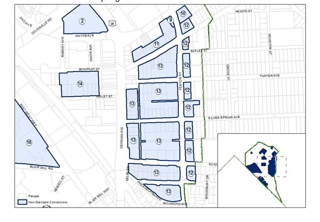
7 MASTER PLAN-DRIVEN TRANSLATION
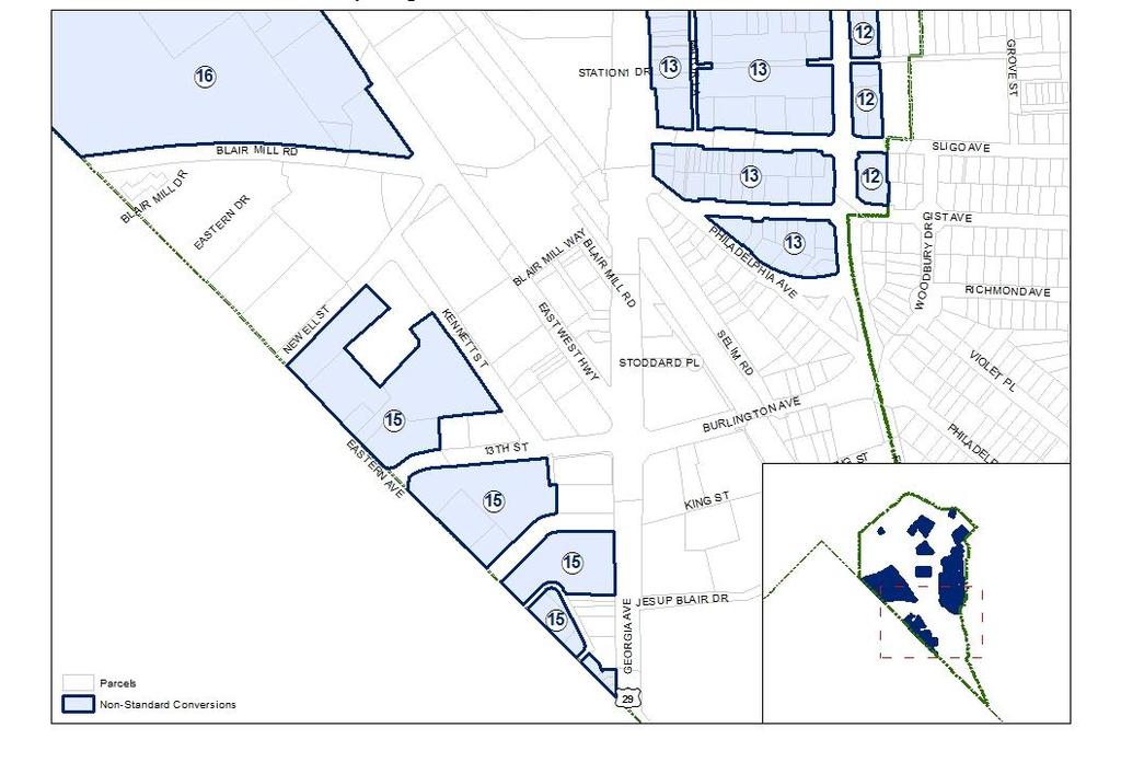

8 MASTER PLAN-DRIVEN TRANSLATION
9 MASTER PLAN-DRIVEN TRANSLATION Area 1 Existing Zoning CBD-1 Proposed Zoning CR-3.0 C-2.0 R-2.5 H-60 Number of Parcels 3 Reason for Non- Master Plan height restriction. Height limited to 60 feet. Relevant Text Silver Spring CBD Master Plan (1993): Page The three single-family houses at the corner of Second Avenue and Fenwick Lane may provide an opportunity for redevelopment in the future. Should redevelopment occur, this Plan recommends a mid-rise residential project (with a 60-foot building height limit) that creates a desirable relationship with the surrounding buildings on Second Avenue. Area 2 Existing Zoning CBD-2 Proposed Zoning CR-5.0 C-3.0 R-4.5 H-200 Number of Parcels 1 Reason for Non- Master Plan recommendations about height. Height allowed to 200 feet. Relevant Text Silver Spring CBD Master Plan (2000): Page 43 Allow additional height above 143 feet on the Silver Triangle site with Planning Board approval. Area 3 Existing Zoning CBD-R2 Proposed Zoning CR-5.0 C-1.0 R-5.0 H-145 Number of Parcels 1 Reason for Non- Master Plan height restriction. Height limited to 145 feet. Relevant Text Silver Spring CBD Master Plan (1993): Page 95 Redevelopment of that portion of the Block 9 fronting on Georgia Avenue north of Fidler Lane should be limited to a height of 143 feet in order to provide an appropriate transition to the adjoining district north of the Core.
10 MASTER PLAN-DRIVEN TRANSLATION Area 5 Existing Zoning CBD-2 Proposed Zoning CR-5.0 C-3.0 R-4.5 H-120 Number of Parcels 15 Reason for Non- Master Plan height restriction. Height limited to 120 feet. Relevant Text Silver Spring CBD Master Plan (1993): Page This Plan encourages ground floor retail uses oriented to the street with frequent shop entrances. The height of this project should not exceed the height of the existing Lee Plaza office building. Area 6 Existing Zoning CBD-3 Proposed Zoning CR-8.0 C-5.0 R-7.5 H-120 Number of Parcels 1 Reason for Non- Master Plan height restriction. Height limited to 120 feet. Relevant Text Silver Spring CBD Master Plan (1993): Page This Plan encourages ground floor retail uses oriented to the street with frequent shop entrances. The height of this project should not exceed the height of the existing Lee Plaza office building.
11 MASTER PLAN-DRIVEN TRANSLATION Area 7 Existing Zoning CBD-2 Proposed Zoning CR-5.0 C-3.0 R-4.5 H-75 Number of Parcels 7 Reason for Non- Master Plan height restriction. Height limited to 75 feet. Relevant Text Silver Spring CBD Master Plan (2000): Page 43 Rezone the National Concrete Ready Mix parcels located on Cedar Street and Ellsworth Drive from CBD-1 to CBD-2 with a height limit of 60 feet, allowing the height to exceed 60 feet up to a maximum height of 75 feet with Planning Board approval based on compatibility with surrounding structures. Area 8 Existing Zoning CBD-1 Proposed Zoning CR-3.0 C-3.0 R-2.5 H-60 Number of Parcels 1 Reason for Non- Master Plan height restriction. Height limited to 60 feet. Relevant Text Silver Spring CBD Master Plan (1993): Page 113 The Plan recommends that Lot 7, i.e, Public Parking Lot 19, should be zoned CBD-1 to facilitate construction of a garage to support the Department Store Mall. If such a garage is built, height in excess of 60 feet should be approved only to the extent necessary to provide a direct connection to the Department Store Mall.
12 MASTER PLAN-DRIVEN TRANSLATION Area 9 Existing Zoning CBD-R2 Proposed Zoning CR-5.0 C-1.0 R-5.0 H-75 Number of Parcels 1 Reason for Non- Overlay Zone height restrictions. Height limited to 75 feet. Relevant Text Montgomery County Zoning Ordinance 59-C (b)(1)(B) [Building Height in the overlay zone] along any street confronting any block that includes property zoned in a one-family residential classification, must not exceed 60 feet Montgomery County Zoning Ordinance 59-C (b)(1)(E) for properties with frontage on both Wayne Avenue and Fenton Street, notwithstanding the height limitations in Subsection (b)(1)(b)-(d), may be increased by 15 feet for a building that includes residential uses or a mix of residential and commercial uses, if such additional height is not more than 200 feet from the right-of-way line for Fenton Street as recommended in the Approved and Adopted 2000 Silver Spring CBD Sector Plan. Area 10 Existing Zoning CBD-1 Proposed Zoning CR-3.0 C-2.0 R-2.5 H-75 Number of Parcels 1 Reason for Non- Overlay Zone height restrictions. Height limited to 75 feet. Relevant Text Montgomery County Zoning Ordinance 59-C (b)(1)(D) [Building Height in the overlay zone] for property located in a block that includes property zones in any one-family residential classification, must not exceed 45 feet for all uses, except the building height must not exceed 60 feet for: (i) residential use; or (ii) mixed-use optional method project, if at least 33% of the project s floor area is residential and the project includes a hotel. Montgomery County Zoning Ordinance 59-C (b)(1)(E) for properties with frontage on both Wayne Avenue and Fenton Street, notwithstanding the height limitations in Subsection (b)(1)(b)-(d), may be increased by 15 feet for a building that includes residential uses or a mix of residential and commercial uses, if such additional height is not more than 200 feet from the right-of-way line for Fenton Street as recommended in the Approved and Adopted 2000 Silver Spring CBD Sector Plan.
13 MASTER PLAN-DRIVEN TRANSLATION Area 11 Existing Zoning CBD-R2 Proposed Zoning CR-5.0 C-1.0 R-5.0 H-110 Number of Parcels 15 Reason for Non- Overlay height restriction. Height limited to 110 feet. Relevant Text Montgomery County Zoning Ordinance 59-C (b)(1)(C) [Building Height in the overlay zone] within the area between a major highway and a street that confronts a block that includes property zoned in any one-family residential classification, must not exceed 60 feet but may increase up to 90 feet the maximum height allowed if at least 33 % of a project s floor area is residential; however, if additional building height is necessary to allow to accommodate workforce housing units and at least 33% of the project s floor area is residential, up to 110 feet and where the additional height is placed near a major highway and decreases in the direction of the closest property zoned in any one-family residential classification Area 12 Existing Zoning CBD-1 Proposed Zoning CR-3.0 C-2.0 R-2.5 H-60 Number of Parcels 23 Reason for Non- Overlay height restriction. Height limited to 60 feet. Relevant Text Montgomery County Zoning Ordinance 59-C (b)(1)(D) property located in a block that includes property zones in any one- family residential classification must not exceed 45 feet for all uses except the building height must not exceed 60 feet for: (i) residential use; or (ii) mixed use optional method project, if at least 33% of the project s floor area is residential and the project includes a hotel.
14 MASTER PLAN-DRIVEN TRANSLATION Area 13 Existing Zoning CBD-1 Proposed Zoning CR-3.0 C-2.0 R-2.5 H-110 Number of Parcels 111 Reason for Non- Overlay height restriction Height limited to 110 feet. Relevant Text Montgomery County Zoning Ordinance 59-C (b)(1)(C) [Building Height in the overlay zone] within the area between a major highway and a street that confronts a block that includes property zoned in any one-family residential classification, must not exceed 60 feet but may increase up to 90 feet the maximum height allowed if at least 33 % of a project s floor area is residential; however, if additional building height is necessary to allow to accommodate workforce housing units and at least 33% of the project s floor area is residential, up to 110 feet and where the additional height is placed near a major highway and decreases in the direction of the closest property zoned in any one-family residential classification Area 14 Existing Zoning CBD-2 Proposed Zoning CR-5.0 C-2.0 R-4.5 H-145 Number of Parcels 9 Reason for Non- Master Plan use mix recommendation. Set maximum commercial FAR to 2.0. Relevant Text Silver Spring CBD Master Plan (1993): Page Block 36 is currently zoned CBD-3. The Plan recommends that Garage 5 and the lots which adjoin it on the south and west, lots 3-6, be rezoned CBD-2 with the requirement that any optional method development should include a minimum of 3 FAR of housing. This will encourage residential development while allowing for commercial use on the lower levels opposite the garage.
15 MASTER PLAN-DRIVEN TRANSLATION Area 15 Existing Zoning CBD-1 Proposed Zoning CR-3.0 C-2.0 R-2.5 H-125 Number of Parcels 17 Reason for Non- Overlay zone height restriction. Height limited to 125 feet. Relevant Text Montgomery County Zoning Ordinance 59-C (b)(1) Building height in the overlay zone along Newell Street and Eastern Avenue that confronts a residential zone in the District of Columbia must not exceed a height of 45 feet. However, this building height may be increased to: (A) a maximum of 90 feet for any building or portion of a building that is set back at least 60 feet from the street; or (B) a maximum of 125 feet for residential development that is set back at least 100 feet from Eastern Avenue and Newell Street and includes a public parking garage constructed under a General Development Agreement with the County. Area 16 Existing Zoning CBD-R2 Proposed Zoning CR-5.0 C-0.5 R-5.0 H-200 Number of Parcels 9 Reason for Non- Zoning text amendment. Commercial FAR set at 0.5. Relevant Text Montgomery County Zoning Ordinance 59-C (a)(ii) 18 and Montgomery County Zoning Ordinance 59-C (b)(iii)(A) 18 On sites of 10 contiguous acres or more, the amount of non-residential development is limited to a maximum of 450,000 gross square feet.
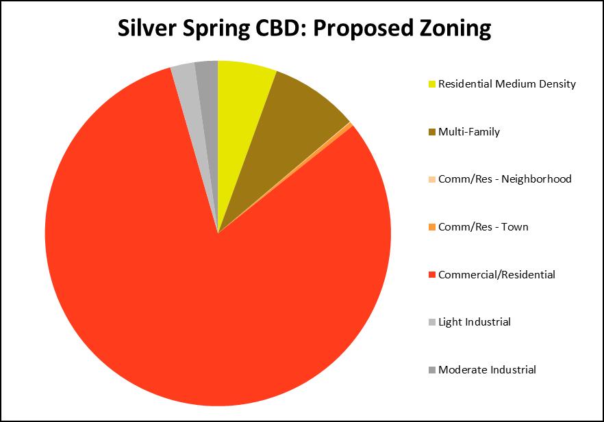
16 ZONE IMPLEMENTATION Silver Spring CBD Existing Proposed Zone Acres Percent Zone Acres Percent R R R R R R CBD CR-1.5 C-1.0 R-1.0 H CR-3.0 C-2.0 R-2.5 H CR-3.0 C-2.0 R-2.5 H CR-3.0 C-2.0 R-2.5 H CBD CR-3.0 C-2.0 R-2.5 H CR-3.0 C-2.0 R-2.5 H CR-3.0 C-3.0 R-2.5 H CR-3.0 C-3.0 R-2.5 H CR-5.0 C-2.0 R-4.5 H CR-5.0 C-3.0 R-4.5 H CBD CR-5.0 C-3.0 R-4.5 H CR-5.0 C-3.0 R-4.5 H CR-5.0 C-3.0 R-4.5 H CR-5.0 C-5.0 R-4.5 H CR-8.0 C-5.0 R-7.5 H CBD CR-8.0 C-5.0 R-7.5 H CR-8.0 C-7.5 R-7.5 H CBD-R CR-3.0 C-0.75 R-3.0 H CR-5.0 C-0.5 R-5.0 H CR-5.0 C-1.0 R-5.0 H CBD-R CR-5.0 C-1.0 R-5.0 H CR-5.0 C-1.0 R-5.0 H CR-5.0 C-1.0 R-5.0 H C CRT-2.5 C-1.5 R-1.5 H C-T CRN-0.5 C-0.5 R-0.25 H I IM-2.5 H I IL-1.0 H Grand Total Grand Total
17
18 EXISTING ZONING MAP Existing Zones Residential Medium Density R-60 Multi-Family R-20 R-10 Commercial C-T C-2 Central Bus. Dist. CBD-0.5 CBD-1 CBD-2 CBD-3 CBD-R1 CBD-R2 Light Industrial I-1 I-4

19 PROPOSED ZONING MAP Proposed Zones Residential Medium Density R-60 Multi-Family R-20 R-10 Comm/Res- Neighborhood CRN Comm/Res- Town CRT Commercial/ Residential CR Light Industrial IL Moderate Industrial IM

20 PLANNING AREA CONTEXT
Master Plan Review WESTBARD
 Master Plan Review WESTBARD Approved and Adopted 1982 Westbard Page 1 of 15 Updated July 2014 based on Adopted DMA ONING CODE REWRITE BACKGROUND In 2007, the Montgomery County Council directed the Planning
GAITHERSBURG VICINITY
 Master Plan Review GAITHERSBURG VICINITY Approved and Adopted 1985 Gaithersburg Vicinity Page 1 of 11 Updated July 2014 based on Adopted DMA ONING CODE REWRITE BACKGROUND In 2007, the Montgomery County
Master Plan Review DAMASCUS. Approved and Adopted May Damascus Page 1 of 19 Updated July 2014 based on Adopted DMA
 Master Plan Review DAMASCUS Approved and Adopted May 2006 Damascus Page 1 of 19 Updated July 2014 based on Adopted DMA ONING CODE REWRITE BACKGROUND In 2007, the Montgomery County Council directed the
Master Plan Review POTOMAC. Approved and Adopted March Updated January 2013
 Master Plan Review POTOMAC Approved and Adopted March 2002 BACKGROUND ZONING CODE REWRITE In 2007, the Montgomery County Council directed the Planning Department to undertake a comprehensive zoning ordinance
Master Plan Review OLNEY. Approved and Adopted April Updated September
 Master Plan Review OLNEY Approved and Adopted April 2005 BACKGROUND ZONING CODE REWRITE In 2007, the Montgomery County Council directed the Planning Department to undertake a comprehensive zoning ordinance
PRESERVATION OF AGRICULTURE
 Master Plan Review PRESERVATION OF AGRICULTURE & RURAL OPEN SPACE Approved and Adopted 1980 BACKGROUND ZONING CODE REWRITE In 2007, the Montgomery County Council directed the Planning Department to undertake
PHED DRAFT Zoning Translation
 Symbol Name Symbol Name Agricultural & Rural RDT Rural Density Transfer AR Agricultural Reserve R Rural R Rural RC Rural Cluster RC Rural Cluster LDRC Low Density Rural Cluster No area zoned LDRC. Zone
Use of the Zoning Ordinance
 Use of the Zoning Ordinance 1. Coordination with Other Chapters A. The use of structures and land within Montgomery County must satisfy all other applicable provisions as well as this Chapter, whether
Article Zones and Zoning Map
 Article 59-2. Zones and Zoning Map [Div. 2.1. Zones Established Sec. 2.1.1. Requirements for all Zones... 2 2 Sec. 2.1.2. Zoning Categories...2 2 Sec. 2.1.3. Agricultural Zone...2 2 Sec. 2.1.4. Rural Residential
Presentation. Agenda Item # 1. Meeting Date February 3, Erkin Ozberk, Planner. Prepared By. Brian T. Kenner City Manager.
 Agenda Item # 1 Presentation Meeting Date February 3, 2014 Prepared By Approved By Erkin Ozberk, Planner Brian T. Kenner City Manager Discussion Item Background Update on Montgomery County s Zoning Code
ARTICLE ZONES DIV ZONES ESTABLISHED DIV ZONING MAP
 ARTICLE 59-2. ZONES DIV. 2.1. ZONES ESTABLISHED SEC. 2.1.1. REQUIREMENTS FOR ALL ZONES... 2 2 SEC. 2.1.2. REGULATIONS FOR ESTABLISHMENT OF ZONES...2 2 SEC. 2.1.3. AGRICULTURAL ZONES...2 2 SEC. 2.1.4. RURAL
Article Optional Method Requirements
 Article 59-6. Optional Method Requirements [DIV. 6.1. MPDU DEVELOPMENT IN RURAL RESIDENTIAL AND RESIDENTIAL ZONES Sec. 6.1.1. General Requirements... 6 2 Sec. 6.1.2. General Site and Building Type Mix...
Staff Memorandum. From: Pamela Dunn, Joshua Sloan,
 THE MARYLAND-NATIONAL CAPITAL PARK AND PLANNING COMMISSION MONTGOMERY COUNTY PLANNING DEPARTMENT Date: May 17, 2013 Staff Memorandum To: Via: Montgomery County Planning Board Rose Krasnow, Interim Planning
Article Zones [DIV ZONES ESTABLISHED DIV ZONING MAP
 Article 59-2. Zones [DIV. 2.1. ZONES ESTABLISHED Sec. 2.1.1. Requirements for all Zones... 2 2 Sec. 2.1.2. Zoning Categories...2 2 Sec. 2.1.3. Agricultural Zone...2 2 Sec. 2.1.4. Rural Residential Zones...
Article Zones and Zoning Map
 Division 2.1. Zones Established Council Draft Article 59-2. Zones and Zoning Map Section 2.1.1. Requirements for All Zones A. Zones established in Article 59-2 must satisfy: 1. Definitions under Article
Zoning Code Training MONTGOMERY COUNTY PLANNING DEPARTMENT. Maryland-National Capital Park and Planning Commission
 Zoning Code Training Highlights New code was adopted on March 5 & DMA was adopted on July 15. Both become effective on October 30. ZTA 14-09 was approved Sept 30 and updates, clarifies, and corrects errors
Bylaw No , being "Official Community Plan Bylaw, 2016" Schedule "A" DRAFT
 Bylaw No. 2600-2016, being "Official Community Plan Bylaw, 2016" Schedule "A" Urban Structure + Growth Plan Urban Structure Land use and growth management are among the most powerful policy tools at the
Chapter 59 Montgomery county zoning ordinance planning board draft
 Chapter 59 Montgomery county zoning ordinance planning board draft Use of the Zoning Ordinance 1. Coordination with Other Chapters A. The use of structures and land within Montgomery County must satisfy
Briefing: Zoning Ordinance Rewrite. April 5, 2013 Montgomery County Planning Department
 Briefing: Zoning Ordinance Rewrite April 5, 2013 Montgomery County Planning Department Topics Goals and Objectives Brief History & Outreach The Big Picture Highlighted Changes What s New How the Pieces
ARTICLE OPTIONAL METHOD REGULATIONS
 ARTICLE 59-6. OPTIONAL METHOD REGULATIONS DIV. 6.1. MPDU DEVELOPMENT IN RURAL RESIDENTIAL AND RESIDENTIAL ZONES SEC. 6.1.1. GENERAL REQUIREMENTS... 6 2 SEC. 6.1.2. GENERAL SITE AND BUILDING T PE MIX...
Article Floating Zone Requirements
 Division 5.1. In General Article 59-5. Floating Zone Requirements Section 5.1.1. Zone Categories There are 4 categories of Floating zones: A. Residential Floating zones (Division 5.2); B. Commercial/Residential
13 Sectional Map Amendment
 13 Sectional Map Amendment Introduction This chapter reviews land use and zoning policies and practices in Prince George s County and presents the proposed zoning in the sectional map amendment (SMA) to
Poughkeepsie City Center Revitalization Plan
 Purpose and Need Purpose Increase job and educational opportunities for all residents Maximize fiscal productivity of downtown land uses Diversify retail mix Eliminate surface and building vacancies Create
GENERAL DESCRIPTION STAFF RECOMMENDATION IMPLEMENTATION REQUIREMENTS
 Application No.: 891418 Applicant: AREA-WIDE MAP AMENDMENT Rezone two parcels from Moderate Density Single Family (MSF) to Neighborhood Center (NC) and Employment Center (EC). Charles Bitton GENERAL DESCRIPTION
MONTGOMERY COUNTY PLANNING DEPARTMENT THE MARYLAND-NATIONAL CAPITAL PARK AND PLANNING COMMISSION
 MONTGOMERY COUNTY PLANNING DEPARTMENT THE MARYLAND-NATIONAL CAPITAL PARK AND PLANNING COMMISSION MCPB Item No. Date: 4-30-15 Zoning Text Amendment (ZTA) No. 15-06, Rural Cluster Zone - Land Use and Setbacks
Appendix A: Guide to Zoning Categories Prince George's County, Maryland
 Appendix A: Guide to Zoning Categories Prince George's County, Maryland RESIDENTIAL ZONES 1 Updated November 2010 R-O-S: Reserved Open Space - Provides for permanent maintenance of certain areas of land
Work Session 2 l Planning Board April 14, 2016
 Work Session 2 l Planning Board April 14, 2016 Tentative Schedule March 24, 2016 April 14, 2016 May 19, 2016 June 2016 Work Session #1: History, Zoning Approach, Affordable Housing Work Session #2: Site
ARTICLE 3: Zone Districts
 ARTICLE 3: Zone Districts... 3-1 17.3.1: General...3-1 17.3.1.1: Purpose and Intent... 3-1 17.3.2: Districts and Maps...3-1 17.3.2.1: Applicability... 3-1 17.3.2.2: Creation of Districts... 3-1 17.3.2.3:
PLANNING COMMISSION WILLIAMSBURG, VIRGINIA WORK SESSION AGENDA Wednesday, May 23, 2012
 PLANNING COMMISSION WILLIAMSBURG, VIRGINIA WORK SESSION AGENDA Wednesday, May 23, 2012 The meeting will be called to order in the third floor Conference Room (Room 310), Williamsburg Municipal Building,
MEMORANDUM. Action-Revised Zoning Text Amendment 16-20, Overlay Zone -Bethesda
 AGENDA ITEM #7 July 11, 2017 Action MEMORANDUM TO: FROM: County Council A/' Jeffrey L. Zyontz, {enior Legislative Analyst July 7, 2017 SUBJECT: Action-Revised Zoning Text Amendment 16-20, Overlay Zone
City of Valdosta Land Development Regulations
 Chapter 206 Section 206-1 Base Zoning Districts Standards for Uses, Structures, and Property Development (B) (C) Principal Uses and Structures. Principal uses and structures permitted in each base zoning
DRAFT Plan Incentives. Part A: Basic Discount
 DRAFT 2030 Plan Incentives July 26, 2006 Part A: Basic Discount In order for a development to be eligible for any 2030 Land Resource Management Plan Discounts it must be located in the Urban Corridor and
Wheaton Sector Plan. Preliminary. Recommendations. Montgomery County Planning Board
 Sector Plan Preliminary Recommendations Montgomery County Planning Board 12-03-09 Scope of Work September 2008 Status Report June 2009 Preliminary Recommendations December 2009 1952 Process Today Community
5/24/2018 RZ Page 1 of 3
 City of Sugar Hill Planning Staff Report RZ 18-004 DATE: May 24, 2018; Updated 6/5/2018 TO: Mayor and City Council FROM: Planning Director SUBJECT: Rezoning RZ 18-004 Ansley Hillcrest LLC, Hillcrest Drive
Zoning Districts Agriculture Low Density Rural Residential Moderate Density Rural Residential High Density Rural Residential Manufactured Home Park
 Zoning 201 Zoning Districts Agriculture Low Density Rural Residential Moderate Density Rural Residential High Density Rural Residential Manufactured Home Park Commercial Lakeside Commercial Rural Transitional
Rose Krasnow, Acting Director,
 MONTGOMERY COUNTY PLANNING DEPARTMENT THE MARYLAND-NATIONAL CAPITAL PARK AND PLANNING COMMISSION Zoning Ordinance Implementation MCPB Item No. 10 Date: 3-7-13 Rose Krasnow, Acting Director, Rose.Krasnow@montgomeryplanning.org,
8.5.1 R1, Single Detached Residential District
 8.5.1 R1, Single Detached Residential District The purpose of this district is to provide for residential development in the form of single detached dwellings. Dwelling, Single Detached Home Business,
Generic Environmental Impact Statement. Build-Out Analysis. City of Buffalo, New York. Prepared by:
 Generic Environmental Impact Statement Build-Out Analysis City of Buffalo, New York 2015 Prepared by: TABLE OF CONTENTS 1.0 INTRODUCTION 1 2.0 METHODOLOGY 2 3.0 EXISTING LAND USE 3 4.0 EXISTING ZONING
Primary Districts Established 4
 4.1 GENERAL PURPOSE SECTION 4 PRIMARY DISTRICTS ESTABLISHED The Town of Waxhaw, North Carolina is hereby divided into PRIMARY ZONING DISTRICTS as designated herein and as shown on the Official Zoning Map.
City of Oshkosh Zoning Update
 City of Oshkosh Zoning Update The Zoning Rewrite Process Commenced in June of 2013 with selection of Vandewalle and Associates as zoning rewrite consultants. Consultants, City Staff, Plan Commission, and
MONTGOMERY COUNTY PLANNING DEPARTMENT THE MARYLAND-NATIONAL CAPITAL PARK AND PLANNING COMMISSION
 MONTGOMERY COUNTY PLANNING DEPARTMENT THE MARYLAND-NATIONAL CAPITAL PARK AND PLANNING COMMISSION MCPB Item No. 3 Date: 05-03-12 Proposed Zoning Text Amendment Revising the Requirements for permitting Accessory
MONTGOMERY COUNTY PLANNING DEPARTMENT THE MARYLAND-NATIONAL CAPITAL PARK AND PLANNING COMMISSION
 MONTGOMERY COUNTY PLANNING DEPARTMENT THE MARYLAND-NATIONAL CAPITAL PARK AND PLANNING COMMISSION MCPB Item No. 9 Date: 06-21-12 Proposed Zoning Text Amendment Revising the Requirements for Permitting Accessory
Implementation. Approved Master Plan and SMA for Henson Creek-South Potomac 103
 Implementation Approved Master Plan and SMA for Henson Creek-South Potomac 103 104 Approved Master Plan and SMA for Henson Creek-South Potomac Sectional Map Amendment The land use recommendations in the
PC Staff Report 11/18/2013 Z Item No. 1-1
 Z-13-00401 Item No. 1-1 PLANNING COMMISSION REPORT Regular Agenda - Public Hearing Item PC Staff Report 11/18/2013 ITEM NO. 1: Z-13-00401 IG (General Industrial) District TO CS (Strip Commercial) District;
Staff Report & Recommendation Rezoning Case RZ Date of Report: June 6, 2014 Report by: Doug Stacks
 Staff Report & Recommendation Rezoning Case RZ-2014-02 Date of Report: June 6, 2014 Report by: Doug Stacks Hearing Dates: Planning Commission June 26, 2014 Mayor and Council July 14, 2014 GENERAL INFORMATION
Jcouncilmembers should bring their copy of the Plan to the meeting.i. PHED Committee #lb October 30, 2017 MEMORANDUM. October 26, 2017 TO:
 PHED Committee #lb October 30, 2017 MEMORANDUM October 26, 2017 TO: FROM: Planning, Housing, and Economic Development (PHED) Committee Marlene Michaelso1ltnior Legislative Analyst SUBJECT: White Flint
Chapter 59 Montgomery County Zoning Ordinance [Planning Board] Preliminary PHED Committee Draft
![Chapter 59 Montgomery County Zoning Ordinance [Planning Board] Preliminary PHED Committee Draft](/thumbs/93/113878370.jpg "Chapter 59 Montgomery County Zoning Ordinance [Planning Board] Preliminary PHED Committee Draft") Chapter 59 Montgomery County Zoning Ordinance [Planning Board] Preliminary PHED Committee Draft [Use of the Zoning Ordinance 1. Coordination with Other Chapters A. The use of structures and land within
Chapter 59 Montgomery County Zoning Ordinance [Planning Board] Preliminary PHED Committee Draft [Use of the Zoning Ordinance 1. Coordination with Other Chapters A. The use of structures and land within
Chapter 10: Implementation
 Chapter 10: Introduction Once the Comprehensive Plan has been adopted by the City of Oakdale, the City can begin to implement the goals and strategies to make this vision a reality. This chapter will set
PLANNING REPORT Gordon Street City of Guelph. Prepared on behalf of Ontario Inc. March 17, Project No. 1507
 PLANNING REPORT 1131 Gordon Street City of Guelph Prepared on behalf of 1876698 Ontario Inc. March 17, 2016 Project No. 1507 423 Woolwich Street, Suite 201, Guelph, Ontario, N1H 3X3 Phone (519) 836-7526
Provide a diversity of housing types, responsive to household size, income and age needs.
 8 The City of San Mateo is a highly desirable place to live. Housing costs are comparably high. For these reasons, there is a strong and growing need for affordable housing. This chapter addresses the
PUBLIC DRAFT May 2017 Zoning Districts Use Regulations Definitions (partial)
") PUBLIC DRAFT May 2017 Zoning Districts Use Regulations Definitions (partial) Table of Contents Subchapter 1: General Provisions... 1 Subchapter 2: Administration & Procedures... 3 Subchapter 3: Zoning
PUBLIC DRAFT May 2017 Zoning Districts Use Regulations Definitions (partial) Table of Contents Subchapter 1: General Provisions... 1 Subchapter 2: Administration & Procedures... 3 Subchapter 3: Zoning
GENERAL PLAN UPDATE SPECIFIC AREAS OF THE CITY
 GENERAL PLAN UPDATE SPECIFIC AREAS OF THE CITY Background There are a total of 14 specific areas that are being reviewed as part of the update of the General Plan. Requests to review these areas came from
From Policy to Reality
 From Policy to Reality Updated ^ Model Ordinances for Sustainable Development 2000 Environmental Quality Board 2008 Minnesota Pollution Control Agency Funded by a Minnesota Pollution Control Agency Sustainable
MONTGOMERY COUNTY PLANNING DEPARTMENT THE MARYLAND-NATIONAL CAPITAL PARK AND PLANNING COMMISSION
 MONTGOMERY COUNTY PLANNING DEPARTMENT THE MARYLAND-NATIONAL CAPITAL PARK AND PLANNING COMMISSION MCPB Item Date: 06/01/17 900 Thayer Avenue: Project Plan Amendment No. 92005003B and Site Plan Amendment
Attachment 4 ANALYSIS I. Current Special Exception Use Standards for Accessory Apartments (Also See Attachment 2 Table for Quick Comparison)
") The Planning Board conducted the first of its public hearings/worksessions on the proposed accessory apartment provisions on May 3, 2012. At that time, the Board determined that additional input from stakeholders
The Planning Board conducted the first of its public hearings/worksessions on the proposed accessory apartment provisions on May 3, 2012. At that time, the Board determined that additional input from stakeholders
VILLAGE OF NORTHBROOK AFFORDABLE HOUSING PLAN
 VILLAGE OF NORTHBROOK AFFORDABLE HOUSING PLAN I. AUTHORITY In 2003, the Illinois General Assembly adopted Public Act 93-0595, the Affordable Housing Planning and Appeals Act, which became effective January
Planning Board Work Session #2 June 7, 2018
 Planning Board Work Session #2 June 7, 2018 1 WORK SESSION #2: OVERVIEW Summary of Work Session #1 Single-Family Parcels at Robindale Drive Department of Recreation Administrative Offices Land Use and
Midwest City, Oklahoma Zoning Ordinance
 2010 Midwest City, Oklahoma Zoning Ordinance 9/2/2010 Table of Contents Section 1. General Provisions... 5 1.1. Citation... 5 1.2. Authority... 5 1.3. Purpose... 5 1.4. Nature and Application... 5 1.5.
Glenmont Sector Plan. Planning Board Public Hearing February 14, spoken testimony letters reports
 Planning Board Public Hearing February 14, 2013 spoken testimony letters email reports Complete set of written testimony and the public hearing transcript is available at the information desk upon request
County of Loudoun. Department of Planning MEMORANDUM
 County of Loudoun Department of Planning MEMORANDUM DATE: September 3, 2013 TO: FROM: Marchant Schneider, Project Manager Land Use Review Marie Genovese, AICP, Planner III, Community Planning SUBJECT:
Zoning and Subdivision Ordinances Public Hearing
 Zoning and Subdivision Ordinances Public Hearing June 14, 2007 Kise Straw & Kolodner Public Process Begun in September 2004 Comprehensive Plan (June 2006) Zoning Ordinance SALDO Comprehensive Plan Committee
NOTICE OF MEETING AND AGENDA FOR THE PLANNING COMMISSION OF SPRINGVILLE, UTAH... JANUARY 23, 2018
 NOTICE OF MEETING AND AGENDA FOR THE PLANNING COMMISSION OF SPRINGVILLE, UTAH............................ JANUARY 23, 2018 Notice is hereby given that the Planning Commission will hold a public meeting
Salem HNA and EOA Advisory Committee Meeting #6
 Salem HNA and EOA Advisory Committee Meeting #6 Residential Land Policies Employment Land Policies Policy Discussions with the Committee Outcome of today s meeting Direction from this Committee on proposed
1. an RSF-R, RSF-1, RSF-2, RSF-4, RMF-5, or RMF-8 zoning district; or
 Chapter 9 INCENTIVES 9.1 General 9.1.1 Review and Approval Procedure Projects requesting bonuses under this chapter for land that has not been platted, or for land that is being voluntarily replatted,
Downtown Development Focus Area: I. Existing Conditions
 Downtown Development Focus Area: I. Existing Conditions The Downtown Development Focus Area is situated along Route 1, south of the train tracks, except for the existing Unilever property. It extends west
Planning Board Worksession No.4: Parklawn South District and Randolph Hills District
 Planning Board Worksession No.4: Parklawn South District and Randolph Hills District Prior Worksessions January 27: Focused on transportation analysis and staging recommendations in the Draft Plan. February
Montreal Road District Secondary Plan [Amendment #127, October 9, 2013]
![Montreal Road District Secondary Plan [Amendment #127, October 9, 2013]](/thumbs/72/66783104.jpg "Montreal Road District Secondary Plan [Amendment #127, October 9, 2013]") [Amendment #127, October 9, 2013] 1.0 General The following policies are applicable to the Montreal Road District as set out in Schedule 1. 1.1 District Objectives The objective of this Plan is to guide
[Amendment #127, October 9, 2013] 1.0 General The following policies are applicable to the Montreal Road District as set out in Schedule 1. 1.1 District Objectives The objective of this Plan is to guide
Evolution of the Vision for NE 181st Street Study Area
 City Council Action on NE 181 St Street Study Area Evolution of the Vision for NE 181st Street Study Area such uses to ensure neighborhood compatibility. More intense uses may be allowed through a conditional
Comprehensive Plan Amendment #PLN , Reserve at Cannon Branch (Coles Magisterial District)
") COUNTY OF PRINCE WILLIAM 5 County Complex Court, Prince William, Virginia 22192-9201 PLANNING (703) 792-7615 FAX (703) 792-4758 OFFICE Internet www.pwcgov.org Christopher M. Price, AICP Director of Planning
COUNTY OF PRINCE WILLIAM 5 County Complex Court, Prince William, Virginia 22192-9201 PLANNING (703) 792-7615 FAX (703) 792-4758 OFFICE Internet www.pwcgov.org Christopher M. Price, AICP Director of Planning
Technology Park Planned Unit Development Technology Park PUD-IP
 Technology Park Planned Unit Development Technology Park PUD-IP Rob Anderson Community Development Director Planned Unit Development Background 2 Planned Unit Development (PUD) means a mixed use redevelopment
Poverty Rates by Census Tracts
 The following document is a presentation that was delivered to the Housing Conservation District Advisory Group (HCDAG). The materials contained in this presentation (including several updates) were prepared
CPC CA 3 SUMMARY
 CPC-2009-3955-CA 2 CONTENTS Summary Staff Report Conclusion 3 4 7 Appendix A: Draft Ordinance A-1 Attachments: 1. Land Use Findings 2. Environmental Clearance 1-1 2-1 CPC-2009-3955-CA 3 SUMMARY Since its
Rezoning Petition Pre-Hearing Staff Analysis April 17, 2017
 Rezoning Petition 2017-041 Pre-Hearing Staff Analysis April 17, 2017 REQUEST Current Zoning: R-5 (single family residential), R-22MF (multifamily residential), and I-1 (light industrial) Proposed Zoning:
CITY OF SANTA ROSA COMMUNITY DEVELOPMENT DEPARTMENT STAFF REPORT FOR PLANNING COMMISSION SEPTEMBER 10, 2015 APPLICANT FILE NUMBER MJP
 ITEM NO. 9 CITY OF SANTA ROSA COMMUNITY DEVELOPMENT DEPARTMENT STAFF REPORT FOR PLANNING COMMISSION SEPTEMBER 10, 2015 PROJECT TITLE Yogurt Time Center ADDRESS/LOCATION 3093 Marlow Road ASSESSOR S PARCEL
MONTGOMERY COUNTY PLANNING DEPARTMENT THE MARYLAND-NATIONAL CAPITAL PARK AND PLANNING COMMISSION
 MONTGOMERY COUNTY PLANNING DEPARTMENT THE MARYLAND-NATIONAL CAPITAL PARK AND PLANNING COMMISSION MCPB Item No. 10 Date: 6-20-13 Zoning Text Amendment (ZTA) No. 13-05, US 29 Overlay Zone Standards Gregory
Puyallup Downtown Planned Action & Code Changes. January 10, 2017
 Puyallup Downtown Planned Action & Code Changes January 10, 2017 Purpose & Location Purpose Promote economic development and downtown revitalization Tools: Municipal Code amendments Change development
Downtown 2025 Sector Development Plan
 Existing Sector / Corridor / Design Overlay Zone Summary Sheet 2025 Sector Web Address: https://www.cabq.gov/planning/documents/copy_of_2025_dec14r.pdf Joint plan with Bernalillo County No Date Adopted/Amended
GOALS, OBJECTIVES, AND STRATEGIES
 GOALS, OBJECTIVES, AND STRATEGIES What follows is a series of goals, recommendations and actions that reflect the themes outlined in the Mineral Springs Vision Plan (incorporated into this document as
4650 Eglinton Avenue West - Zoning By-law Amendment Application - Preliminary Report
 STAFF REPORT ACTION REQUIRED 4650 Eglinton Avenue West - Zoning By-law Amendment Application - Preliminary Report Date: August 14, 2015 To: From: Wards: Reference Number: Etobicoke York Community Council
Town of Waxhaw Board of Commissioners. Waxhaw Police Department Community Meeting Room Tuesday January 12, 2016
 Town of Waxhaw Board of Commissioners Waxhaw Police Department Community Meeting Room Tuesday January 12, 2016 Petition RZ-003994-2015 A request by the Town of Waxhaw Planning & Community Development Department,
MCPB Item No. 2 Date: Zoning Ordinance Revision: Staff Draft of the Overlay and Floating Zones
 MONTGOMERY COUNTY PLANNING DEPARTMENT THE MARYLAND-NATIONAL CAPITAL PARK AND PLANNING COMMISSION MCPB Item No. 2 Date: 11-28-12 Zoning Ordinance Revision: Staff Draft of the Overlay and Floating Zones
Amendments to Chapter proposed by the Assembly Title 21 Committee
 Amendments to Chapter 21.04 proposed by the Assembly Title 21 Committee All page numbers refer to the S version. PZC recommended additions are underlined. PZC recommended deletions are in [BRACKETS AND
Route 6 Corridor Study Bristol Planning Commission Meeting #1. May 25, 2016 FITZGERALD & HALLIDAY, INC. Innovative Planning, Better Communities
 Route 6 Corridor Study Bristol Planning Commission Meeting #1 May 25, 2016 FITZGERALD & HALLIDAY, INC. Innovative Planning, Better Communities Today s Agenda 1. Introductions 2. Study overview Scope Schedule
ARLINGTON COUNTY, VIRGINIA. County Board Agenda Item Meeting of September 19, 2015
 ARLINGTON COUNTY, VIRGINIA County Board Agenda Item Meeting of September 19, 2015 DATE: August 28, 2015 SUBJECT: Request to authorize advertisement of public hearings by the Planning Commission and the
Village WASHINGTON TOWNSHIP MASTER PLAN SYNTHESIS. Page 197
 Village P l a n WASHINGTON TOWNSHIP MASTER PLAN SYNTHESIS Page 197 SECTION 11.0 MASTER PLAN SYNTHESIS INTRODUCTION The proposals presented in the various plans result in a graphic synthesis: The Land Use
Place Type Descriptions Vision 2037 Comprehensive Plan
 Place Type Descriptions Vision 2037 Comprehensive Plan The Vision 2037 Comprehensive Plan establishes a range of place types for Oxford, ranging from low intensity (limited development) Rural and Natural
ORDINANCE NO
 ORDINANCE NO. 20050519-008 AN ORDINANCE AMENDING CHAPTERS 25-2 AND 25-6 OF THE CITY CODE TO ADD A NEW ZONING DISTRICT RELATING TO TRANSIT ORIENTED DEVELOPMENT. BE IT ORDAINED BY THE CITY COUNCIL OF THE
DRAFT FOR DISCUSSION PURPOSES ONLY. Port Credit Local Area Plan Built Form Guidelines and Standards DRAFT For Discussion Purposes
 Port Credit Local Area Plan Built Form Guidelines and Standards DRAFT For Discussion Purposes 1 Local Area Plan - Project Alignment Overview Directions Report, October 2008 (General Summary Of Selected
By: District Council at Request of the Planning Board. AN AMENDMENT to the Montgomery County Zoning Ordinance to:
 Zoning Text Amendment No: 08-14 Concerning: Transit Mixed-Use (TMX) Zone- Establishment Draft No. & Date: 2-6/23/08 Introduced: ublic Hearing: Adopted: Effective: Ordinance No: COUNTY COUNCIL FOR MONTGOMERY
PLANNING REPORT. 33 Arkell Road City of Guelph. Prepared on behalf of OHM Arkell Inc. August 4, Project No. 1327
 PLANNING REPORT 33 Arkell Road City of Guelph Prepared on behalf of OHM Arkell Inc. August 4, 2015 Project No. 1327 423 Woolwich Street, Suite 201, Guelph, Ontario, N1H 3X3 Phone (519) 836-7526 Fax (519)
density framework ILLUSTRATION 3: DENSITY (4:1 FSR) EXPRESSED THROUGH BUILT FORM Example 1
 EXPRESSED THROUGH BUILT FORM Example 1") density framework 4 ILLUSTRATION 3: DENSITY (4:1 FSR) EXPRESSED THROUGH BUILT FORM INTRODUCTION The Downtown Core Area contains a broad range of building forms within its relatively compact area. These
density framework 4 ILLUSTRATION 3: DENSITY (4:1 FSR) EXPRESSED THROUGH BUILT FORM INTRODUCTION The Downtown Core Area contains a broad range of building forms within its relatively compact area. These
Planning Commission Public Hearing
 Planning Commission Public Hearing 2016 Annual s to the Comprehensive Plan and Land Use Regulatory Code. Planning Commission Public Hearing Wednesday, May 4, 2016, 5:00 p.m. City Council Chambers Tacoma
DRAFT Value Capture Ordinance May 25, 2017 CPC CA ORDINANCE NO.
 ORDINANCE NO. An ordinance amending Sections 12.24, 14.00, and 14.3.1 of the Los Angeles Municipal Code to clarify existing regulations and align affordability requirements across the range of zoning entitlements
Chapter MIXED USE ZONING DISTRICTS
 Page 1 of 12 Page 1/12 Chapter 17.18 MIXED USE ZONING DISTRICTS Sections: 17.18.010 Purposes. 17.18.020 Permitted, conditional and prohibited uses. 17.18.030 Bulk, 17.18.010 Purposes. A. Mixed Use Districts.
Residential Capacity Estimate
 Residential Capacity Estimate Montgomery County Department of Park & Planning Research & Technology Center January 2005 Current plans allow 75,000 more housing units. by Matthew Greene, Research Planner
APPENDIX A PART 1: GENERAL PLAN AMENDMENTS
 APPENDIX A PART 1: GENERAL PLAN AMENDMENTS I. CHANGES TO MAPS Amend the following figures to include the Plan Area boundaries: Chapter 4, Figure 15. Specific Plan Boundaries Chapter 4, Figure 16. Core
CHAPTER Committee Substitute for Committee Substitute for Senate Bill No. 2188
 CHAPTER 2004-372 Committee Substitute for Committee Substitute for Senate Bill No. 2188 An act relating to land development; amending s. 197.502, F.S.; providing for the issuance of an escheatment tax
SECTION 3. Housing. Appendix A LAND USE DEFINITIONS
 SECTION 3 Housing A Appendix A LAND USE DEFINITIONS A-2 Housing Commission Attachment B Appendix A Land Use Definitions INTRODUCTION The Land Use Map (Figure A-1) of Community Vision 2040 illustrates the
Rule 80. Preservation of Primary Agricultural Soils Revised and approved by the Land Use Panel during its public meeting on January 31, 2006.
 Rule 80. Preservation of Primary Agricultural Soils Revised and approved by the Land Use Panel during its public meeting on January 31, 2006. (A) Purpose. In accordance with 10 V.S.A. Sections 6025(b)
GATEWAY DISTRICTS DRAFT ZONING & DEVELOPMENT STANDARDS City of Portsmouth, NH
 GATEWAY DISTRICTS DRAFT ZONING & DEVELOPMENT STANDARDS City of Portsmouth, NH PLANNING BOARD WORKSHOP June 22, 2017 Brovitz Community Planning & Design HOUSING INITIATIVES Portsmouth 2025 Master Plan (2017)