Subdivision of Fractional Sections ISPLS 2017
|
|
|
- Lewis Harrington
- 5 years ago
- Views:
Transcription

1 Subdivision of Fractional Sections ISPLS 2017 Dennis J. Mouland, PLS Instructor Witness Tree Consulting, Inc., 2011, All Rights Reserved
2 Course Objectives Understand the definition of a fractional section from the surveyor s viewpoint See the Federal Law on this topic, and learn how and when to apply it Learn how to compute a weighted mean bearing See how this applies to completion surveys
3 First; some terminology RETURNS Official reports. In cadastral survey parlance, the returns are the field notes, report and approved plat of a survey. Any measurement approved is considered a return

4 How did they measure those to get a return?
.")
5 FIXED The law presumes that a corner has not been fixed when: (1) the section line on each side of the corner position has not been actually run (figure 3 44) or, (2) the section line has been actually run but at least one corner on each side, on the section line at issue, has not been monumented (figure 3 45). The rule presumes that a section line has been actually run when a bearing and distance of the line is returned in the official survey record.
6 Fractional Section By law a fractional section is (1) a section containing outlying areas protracted as surveyed, or (2) an invaded section in which at least one quarter section corner has not been or cannot be fixed. The method of subdivision by survey is outlined in 43 U.S.C. 752(2)(cl. 3) and 753(cls. 2 and 4). By rule the procedure for subdivision of the fractional section is to be as nearly as possible in conformity with the official survey.
7 Fractional Sections Dennis s definition: A section with one or more of it s controlling corners never established (Established = fixed) Established? Was a return published on the distances controlling it? Sometimes a section may not be fractional but a quarter section of it is fractional by the BLM definition Beware using fractional term just because a deed or patent uses it; fractional is a term for title issues when a parcel is less than 40 acres. This often does not trigger the survey definition of fractional. The SW1/4 of the NW1/4 of fractional Section 3, T, R, M
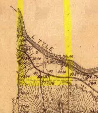
8 Sections 17, 18, and 19 are all fractional. They have no returns across the lake. Those lines were not run nor approved by the GLO. Section 20 has a fractional NW1/4. Ties to islands are not approved PLSS lines and should not be used in retracements.
9 Are these sections Fractional? Note the returns. These can all be subdivided normally
10 NOT fractional, so subdivide normally


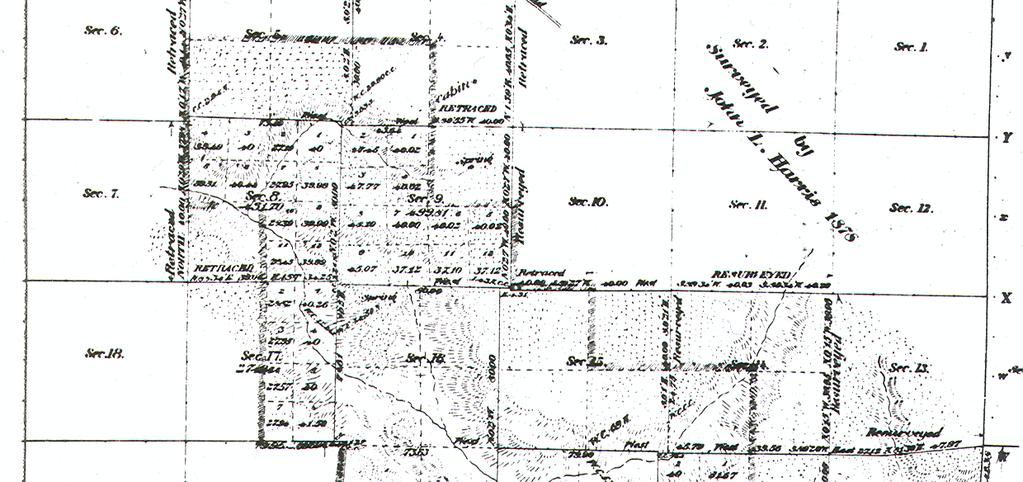
11 The fact that the ¼ corners of minimum control were not set DOES NOT make these sections fractional
12
13 Federal Law on Fractional Sections Act of Feb. 11, 1805 said: Regarding fractional sections, the subdivisional lines shall be run in cardinal directions. Jared Mansfield was Surveyor General, and he immediately interpreted this law in this manner: Congress presumed the section lines were cardinal, therefore we must adjust the subdivisional lines if the section lines are found to be other than cardinal.
14 Mansfield s concerns
15 EXAMPLE: Section 17 E/W centerline What bearing? Congress addressed this in the 1805 Act. Regarding fractional sections, the subdivisional lines shall be run in cardinal directions. Mansfield immediately interpreted this to require mean bearings. We now use weighted mean or parallel lines as the facts dictate
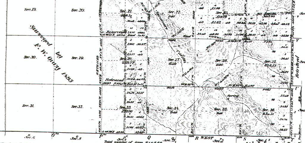
16 Application of Fractional Rules Weighted Mean Bearing if: You have two or more lines to weight against; the longer lines control the mean more than the shorter. Run Parallel Lines if: You only have one sideline to which you can apply the intent of the plat. Used where no other section line exists or if the plat indicates not to spread adjustment through the entire section.
17 Parallel line and Weighted Mean Example
18 How do you compute a weighted mean? In COGO, connect all the lines you are using in the calc end to end with your measured data. Inverse between the two end points and the result is a perfectly weighted mean. B/D 2 B/D 3 B/D 1
19 EXAMPLE: Section 17 E/W centerline weighted mean: NE Cor S17 to N1/4 S17 = N89W N1/4 S17 to NW Cor S17= N88W SE Cor S17 to S1/4 S17= S89 30W S1/4 S17 to MC S17/S20= N84W 3.18 Place these end to end in a traverse routine. Inverse for answer: N W
20 Parallel lines when nothing to mean against
21 Section 20: C1/4 can be set normally. Only the NW1/4 needs the special rules, after the CW and CN1/16ths are set normally. Back in
22 Back in Section 17, how would you set the CW1/16 th?
23 Intended to be parallel
24 The east line of the western tier of sections was intended to be parallel to the east twp bdy. And since the ¼ s of those sections are at 40 chains rather than midpoint, and since their W1/16ths are at 20 chains, then the plats intent is for the entire effect of convergence to be thrown into the western lots. So to subdivide S19 with any type of mean bearing would violate the intent of the plat!
25 Parallel line must be used to protect the plat

26 Subdivisional Corners created? Yes, but not monumented: Supreme Court has ruled they were all fixed by the plat Not synonymous terms; monument, corner, fixed Corner is a point on the surface of the earth, a location Monument is a physical object claiming to be at a corner point
27 Finally, Completion Surveys
28 Original Surveys/Extensions/Completions Original survey creates boundaries, but not all townships done in their entirety Extensions add to an incomplete twp, but not finish it Completions finish a partially surveyed township Always create jr/sr in odd places What do you mean, unsurveyable?
29 What do you mean, Unsurveyable? Lands not yet surveyed. Fractional section surveys for example, leave unsurveyed land within a section. The land is known to exist but the survey has either not yet been authorized or has not yet been completed. Congress did not authorize surveying of waste land that could not support agriculture
30 Example Extension Survey ORIGINAL EXTENSION

31 Example Completion Survey Cross hatching Indicates where Jr/sr is taking Place ORIGINAL Double corners Offsets All because of the Main Goals, and Rectangular limits EXTENSION COMPLETION
32 Completions show up in strange ways

33 Land Grants are senior to the PLSS


34 Grant declared invalid, so remaining PD must be surveyed. Note closings on both sides of line, even though it is a rejected boundary.

35 In reality, the record supports the fact there are two Section 34 s in this township, and are both fractional.

36

37
38 Some Townships are very complicated! Are there completions or extension surveys for which you need data????
39 Sec 2 Sec 1 Sec 11 Sec 12
40

41 Section Subdivisions Arrangement of lotting gives us the clues to how to subdivide a section Bona Fide Rights are tied to these records, so our surveys must do so as well Remember that junior/senior issues, including odd parentheticals, double corners, and heavy bearings, can all impact locations of parcels
42 Completions with jr/sr inside the section
43 Parallel lines on partially surveyed sections Suppose the NE1/4 of Section 15 went to patent, and assume the GLO never did a completion survey here. How would you set the C1/4? Parallel lines to intersect = C1/4


44 Completions with jr/sr inside the section Lotting present No lotting present
45 What did we learn? Research the record Be sure you have all of it Let the plat tell you what to do Recognize that fractional sections exist, and can come in some very surprising places NEVER assume anything when working in the PLSS
46 Course Objectives Met? Understand the definition of a fractional section from the surveyor s viewpoint See the Federal Law on this topic, and learn how and when to apply it Learn how to compute a weighted mean bearing See how this applies to completions surveys

47 Subdivision of Fractional Sections Thank you for your participation! Witness Tree Consulting, Inc. Dennis J. Mouland, PLS, Instructor Witness Tree Consulting, Inc., 2011, All Rights Reserved
Where the 2009 Manual is Silent
 Where the 2009 Manual is Silent A seminar for the Professional Land Surveyor Dennis J. Mouland, PLS, Instructor PLSO 2014 A long history of Manuals Original contracts and instructions 1851 Oregon Instructions
Group Break Out. What, if anything, sends up a red flag? What does the lotting along the North and South centerline suggest? What are your next steps?
 What is the NW ¼? What is the NW ¼? You are hired to survey your client s property in Section 8. His deed says NW ¼ Section 8, T. 40 S., R. 07 E. According to the county, it is Tax Lot 700. He gives you
BUREAU OF LAND MANAGEMENT. Fractional Sections. With John Farnsworth and Belle Craig C A D A S T R A L S U R V E Y
 BUREAU OF LAND MANAGEMENT Fractional Sections With John Farnsworth and Belle Craig 2009 C A D A S T R A L S U R V E Y Fractional Sections There are two types of fractional sections referenced in the 1973
Certified Federal Surveyor Program Assignment #6, Feedback
 Certified Federal Surveyor Program Assignment #6, Feedback Now that you have completed Assignment #6, take a few minutes to review the comments below. We have tried to identify items of special importance,
Preparing Property descriptions D A V I D T. BUTCHER, PLS
 Preparing Property descriptions D A V I D T. BUTCHER, PLS Who can prepare property descriptions? 327.272. Practice as professional land surveyor defined. 1. A professional land surveyor shall include any
CFedS Outline Unit 1. Course 1: History, Records & Administrative Systems
 CFedS Outline Unit 1 Course 1: History, Records & Administrative Systems History of U.S. Surveying Historical Perspective Similarities in Surveying Seniority of Calls Lack of Standards A National Debt
Center of Section. Computed or Monumented Position. Review and Commentary
 Center of Section Computed or Monumented Position Review and Commentary Center of Section Center of section defined by law for more than 200 years Computed position vs monumented position Examine the state
THE THREE MILE METHOD OF SURVEYING IN THE UTE MERIDIAN. Mesa County, Colorado
 THE THREE MILE METHOD OF SURVEYING IN THE UTE MERIDIAN Mesa County, Colorado Mesa County, located at the confluence of the Grand (Colorado) and Gunnison Rivers on the Western Slope, is a very unique area
Corner Evidence Analysis. Instructor: Dennis J. Mouland, PLS
 Corner Evidence Analysis Instructor: Dennis J. Mouland, PLS Witness Tree Consulting, Inc., 2011 Course Goals Corner Evidence Analysis We will.. 1. Review the need for evidence search 2. Review tools for
CHAPTER 8 - LAND DESCRIPTIONS
 CHAPTER 8 - LAND DESCRIPTIONS Notes: While the location of land is commonly referred to by street number and city, it is necessary to use the legal description in the preparation of those instruments relating
P.F. WOOD, APPELLANT, V. C. MANDRILLA, RESPONDENT. SAC. NO SUPREME COURT
 Supreme Court of California,Department Two. 167 Cal. 607 {Cal. 1914) WOOD V. MANDRILLA P.F. WOOD, APPELLANT, V. C. MANDRILLA, RESPONDENT. SAC. NO. 2089. SUPREME COURT OF CALIFORNIA,DEPARTMENT TWO. APRIL
Certified Federal Surveyor Program Assignment #3, Feedback
 Certified Federal Surveyor Program Assignment #3, Feedback Now that you have completed Assignment #3, take a few minutes to review the comments below. We have tried to identify items of special importance,
WHEN DANIEL BOONE led pioneers across the
 Understanding Land Measurement and Legal Descriptions WHEN DANIEL BOONE led pioneers across the Appalachian Mountains in the 1700s, it was an accepted practice for them to establish property boundaries
U.S. Public Land Survey - Special Instructions A Case Study
 U.S. Public Land Survey - Special Instructions A Case Study by: John E. Freemyer, LS "One of the most important duties to be performed by the surveyor general is to provide the deputy surveyor with Special
NORTH CAROLINA PROPERTY MAPPERS ASSOCIATION SECTION 6 PUBLIC LANDS
 NORTH CAROLINA PROPERTY MAPPERS ASSOCIATION SECTION 6 PUBLIC LANDS 6-1 6.1 Introduction Following our independence from England, the Congress in 1783 of the newly formed United States of America was faced
WYANDOT COUNTY BASIC STANDARDS FOR THE APPROVAL OF REAL ESTATE DEED TRANSFERS & LAND CONTRACT AGREEMENTS
 GENERAL In compliance with Section 315.251 of the Ohio Revised Code, the County Auditor and the County Engineer have adopted these written standards governing the conveyance of real property in Wyandot
CHAPTER 7 - LAND DESCRIPTIONS
 An * in the left margin indicates a change in the statute, rule or text since the last publication of the manual. CHAPTER 7 - LAND DESCRIPTIONS While the location of land is commonly referred to by street
The Public Land Surveys in Minneapolis and St Paul. A Surveying Potboiler
 The Public Land Surveys in Minneapolis and St Paul A Surveying Potboiler A Surveying Potboiler (Imagine seductive soap opera music) Land ceded in three different treaties Land surveyed under two sets of
RESTORATION OF LOST OR OBLITERATED CORNERS & SUBDIVISION OF SECTIONS a guide for surveyors
 DISCLAIMER The following is a retyped electronic version of "RESTORATION OF LOST OR OBLITERATED CORNERS AND SUBDIVISION SECTIONS", a supplement to the Manual of Surveying Instructions, designed to be word
Methods of Legal Description Metes and Bounds The Rectangular Survey System Recorded Plat Method Describing Elevation
 9 Legal Descriptions Methods of Legal Description Metes and Bounds The Rectangular Survey System Recorded Plat Method Describing Elevation METHODS OF LEGAL DESCRIPTION There are many common ways of describing
CHAPTER FINAL AND PARCEL MAPS
 CHAPTER 19.48 FINAL AND PARCEL MAPS Section Page 19.48.010 General... IV-25 19.48.020 Phasing... IV-25 19.48.030 Survey Required... IV-26 19.49.040 Form... IV-26 19.48.050 Contents... IV-27 19.48.060 Preliminary
Concerns about Methodology
 1979 NDSPLS ADMINISTRATIVE OFFICE PO Box 7370 Bismarck, ND 58507 Phone: 701-223-3184 E-mail: info@ndspls.org Website: www.ndspls.org North Dakota Industrial Commission Department of Mineral Resources Lynn
Methods of Legal Description. Deeds and Land Descriptions. Government Survey (PLSS)
") Deeds and Land Descriptions Methods of Legal Description Government survey (PLSS): boundaries identified relative to rectangular national grid as established by 1785 Act of Congress Metes and bounds: boundaries
Deeds and Land Descriptions Methods of Legal Description Government survey (PLSS): boundaries identified relative to rectangular national grid as established by 1785 Act of Congress Metes and bounds: boundaries
Printable Lesson Materials
 Printable Lesson Materials Print these materials as a study guide These printable materials allow you to study away from your computer, which many students find beneficial. These materials consist of two
Collateral Evidence Analysis
 Wisconsin Society of Land Surveyors 2019 Surveyors Institute Wisconsin Dells, Wisconsin January 24, 2019 Collateral Evidence Analysis Stanley French Chief Cadastral Surveyor for Idaho (retired) Land Boundary
THE PURPOSE OF MEASUREMENTS IN BOUNDARY SURVEYS. (THE ETERNAL SUVRVEY QUESTION: HOW CLOSE IS CLOSE ENGOUGH?) By. Norman Bowers, P.S. & P.E.
 By. Norman Bowers, P.S. & P.E.") THE PURPOSE OF MEASUREMENTS IN BOUNDARY SURVEYS (THE ETERNAL SUVRVEY QUESTION: HOW CLOSE IS CLOSE ENGOUGH?) By Norman Bowers, P.S. & P.E. Steven S. Brosemer, P.S. Figure 1 Surveyors are all about measurements.
THE PURPOSE OF MEASUREMENTS IN BOUNDARY SURVEYS (THE ETERNAL SUVRVEY QUESTION: HOW CLOSE IS CLOSE ENGOUGH?) By Norman Bowers, P.S. & P.E. Steven S. Brosemer, P.S. Figure 1 Surveyors are all about measurements.
Survey and Recording Requirements
 Article C: Sec. 14-1-40 Survey and Recording Requirements Survey Requirements. (a) (b) (c) Prior to the final approval of land divisions to which this Chapter applies, the owner of the land shall have
The Public Land Survey Records for Minnesota It s a square world. Déjà vu - Again
 The Public Land Survey Records for Minnesota It s a square world Déjà vu - Again Presentations 2007 MSPS. The Past as Prolog: Public Land Survey Records for Minnesota Mn/DOT. A Partial Inventory of the
Certified Survey Review Instructions
 DEARBORN COUNTY PLAN COMMISSION County Administration Building, 165 Mary St., Lawrenceburg, IN 47025 Phone (812) 537-8821 Fax (812) 532-2029 Website: www.dearborncounty.org/planning Certified Survey Review
Standards of Practice for Surveying in the State of Alabama
 Standards of Practice for Surveying in the State of Alabama Effective January 1, 2017 RULE NO. 1.01 PURPOSE The purpose of these rules is to establish standards for the practice of surveying in the State
Hello Plat Review, I have a question.
 Hello Plat Review, I have a question. January 24, 2018 2018 Surveyors' Institute 1 When do I have to do a subdivision plat? January 24, 2018 2018 Surveyors' Institute 2 236.02 (12) Definitions. Requires
A B. C Submission. Subdivision Application under The Planning Act C.C.S.M. c. P80
 under The Planning Act C.C.S.M. c. P80 A Before B Application You Start Meet with a planner at your local Community and Regional Planning office to discuss your proposed subdivision. Requirements C Submission
Oakland County Michigan Register of Deeds Plat Engineering, GIS, & Remonumentation Dept. Ph: (248) Fax (248)
 Fax (248)") Oakland County Michigan Register of Deeds Plat Engineering, GIS, & Remonumentation Dept. Ph: (248)-858-1447 Fax (248)-858-7466 Requirements Needed for Final Plat Approval No. General Requirements. 1 Routing
Oakland County Michigan Register of Deeds Plat Engineering, GIS, & Remonumentation Dept. Ph: (248)-858-1447 Fax (248)-858-7466 Requirements Needed for Final Plat Approval No. General Requirements. 1 Routing
Hello Plat Review, I have a question.
 Hello Plat Review, I have a question. January 23, 2019 2019 Surveyors' Institute 1 1 A question came up at a town board meeting last night. I m doing 2 lots west of the road. Then I m doing 2, one lot
Finding and Prioritizing Boundary Evidence
 Finding and Prioritizing Boundary Evidence THREE PHASES OF A RETRACEMENT SURVEY Collect and Analyze the Record Evidence Perform a Field Survey to Search for Evidence Referenced in the Record and Signs
United States Department of the Interior Bureau of Land Management Cadastral Survey
 United States Department of the Interior Bureau of Land Management Cadastral Survey Specifications for Descriptions of Land: For Use in Land Orders, Executive Orders, Proclamations, Federal Register Documents,
LEGAL ASPECTS OF LAND SURVEYING
 LEGAL ASPECTS OF LAND SURVEYING By: Dr. Tony Nettleman Copyright Nettleman Land Surveying, INC (2016) Fig: Welcome Picture YOUR SPEAKER Surveying All My Life Began Working with Attorneys Went to College
TOWN OF LYONS, COLORADO ORDINANCE NO. 1017
 TOWN OF LYONS, COLORADO ORDINANCE NO. 1017 AN ORDINANCE OF THE BOARD OF TRUSTEES OF THE TOWN OF LYONS ANNEXING TO THE TOWN OF LYONS CERTAIN REAL PROPERTY OWNED BY THE TOWN OF LYONS WHEREAS, the Town of
BOUNDARY SURVEYS RE-SURVEYS
 BOUNDARY SURVEYS RE-SURVEYS One of the difficult tasks for a surveyor is the re-surveying of lands, the re-location of the boundary lines between privately-owned lands or the re-location of the boundary
DISCREPANCIES IN THE OFFICIAL RECORD
 DISCREPANCIES IN THE OFFICIAL RECORD The The lines The corners lengths marked set of by the the section Surveyor General lines are are are unchangeable. unchangeable 1. Inconsistencies on the face of the
OTTAWA COUNTY LEGAL DESCRIPTION REVIEW GUIDELINES
 OTTAWA COUNTY LEGAL DESCRIPTION REVIEW GUIDELINES APPROVED BY: RONALD P. LAJTI, JR., P.E., P.S. OTTAWA COUNTY ENGINEER APPROVED BY: LAWRENCE HARTLAUB OTTAWA COUNTY AUDITOR EFFECTIVE DATE: January 1, 2017
PROPERTY IDENTIFICATION INSTRUCTOR: CHERYL B. BELLA, MAI SPONSOR: THE GREATER BATON ROUGE ASSOCIATION OF REALTORS
 PROPERTY IDENTIFICATION INSTRUCTOR: CHERYL B. BELLA, MAI SPONSOR: THE GREATER BATON ROUGE ASSOCIATION OF REALTORS PROPERTY IDENTIFICATION 5 Hour Indoctrination Course A) Classification of Property Type
APPLICATION FOR MAJOR SUBDIVISION APPROVAL (FINAL PLAT)
") 209 S. Main Street Marysville, Ohio 43040 Phone: (937) 645-7350 Fax: (937) 645-7351 www.marysvilleohio.org APPLICATION FOR MAJOR SUBDIVISION APPROVAL (FINAL PLAT) *** IMPORTANT INFORMATION ~ Please read
209 S. Main Street Marysville, Ohio 43040 Phone: (937) 645-7350 Fax: (937) 645-7351 www.marysvilleohio.org APPLICATION FOR MAJOR SUBDIVISION APPROVAL (FINAL PLAT) *** IMPORTANT INFORMATION ~ Please read
Preparation of Deed Descriptions
 Preparation of Deed Descriptions SURVCON 2019 Wednesday, February 6, 2019 BALLYS- Atlantic City, New Jersey Presented by Bruce R Blair PLS, PP 1 INTRODUCTION The New Jersey administrative code 13:40 5.1
Administrative Plat Submittal Checklist (Minor, Development)
") Planning & Community Development Department 550 Landa Street New Braunfels, Texas 78130 (830) 221-4050 www.nbtexas.org CC/Cash/Check No.: Amount Recd. $ Receipt No.: Case No.: Submittal date office use
Planning & Community Development Department 550 Landa Street New Braunfels, Texas 78130 (830) 221-4050 www.nbtexas.org CC/Cash/Check No.: Amount Recd. $ Receipt No.: Case No.: Submittal date office use
APPROVAL REQUIREMENTS
 APPROVAL REQUIREMENTS FOR INSTRUMENTS OF CONVEYANCE IN ERIE COUNTY, OHIO DRAFT Requirements for all instruments of Conveyance in Erie County, revised and effective, 2014. An Erie County policy governing
Final Plat Submittal Checklist
 Planning & Community Development Department 550 Landa Street New Braunfels, Texas 78130 (830) 221-4050 www.nbtexas.org CC/Cash/Check No.: Amount Recd. $ Receipt No.: Submittal date office use only Final
May 2012 Professional (Cadastral) Examination
 Examination") Page 1 of 6 Question 1 a) Name five (5) types of plans for which the limits may be un-dimensioned. (5 marks) b) Name five (5) types of plans that create geographic fabric. (5 marks) Question 2 A client
Page 1 of 6 Question 1 a) Name five (5) types of plans for which the limits may be un-dimensioned. (5 marks) b) Name five (5) types of plans that create geographic fabric. (5 marks) Question 2 A client
MINUTES OF A REGULAR PLANNING COMMISSION MEETING HELD, TUESDAY, OCTOBER 11, :30 P.M. ROCKVILLE CITY HALL
 28 MINUTES OF A REGULAR PLANNING COMMISSION MEETING HELD, TUESDAY, OCTOBER 11, 2011 6:30 P.M. ROCKVILLE CITY HALL The meeting was called to order by Chair Toni Honer. Roll call was taken and the following
COLLIER COUNTY WAIVER APPLICATION FROM THE REQUIRED HISTORICAL AND ARCHAEOLOGICAL SURVEY AND ASSESSMENT PETITION NUMBER ASSOCIATED WITH THE WAIVER:
 COLLIER COUNTY WAIVER APPLICATION FROM THE REQUIRED HISTORICAL AND ARCHAEOLOGICAL SURVEY AND ASSESSMENT DATE SUBMITTED: PLANNER: PETITION NUMBER ASSOCIATED WITH THE WAIVER: (To Be Completed By Zoning and
(10) The Board has the powers and duties of an arbitrator under sections 29(3) and 43 of the Arbitration Act.
 The Board has the powers and duties of an arbitrator under sections 29(3) and 43 of the Arbitration Act.") Surveys Act [Fall 2014 STATUTE LAW] Under section 9 survey error investigation of the Surveys Act. The Minister may appoint a Board consisting of three (3) members. a. List two (2) of the three (3) members.
Surveys Act [Fall 2014 STATUTE LAW] Under section 9 survey error investigation of the Surveys Act. The Minister may appoint a Board consisting of three (3) members. a. List two (2) of the three (3) members.
LAND INFORMATION SYSTEMS PLSS ORDINANCE. Ordinance No Public Land Survey System (PLSS) Remonumentation
 Remonumentation") Page 1 of 6 PLSS ORDINANCE Ordinance No. 287-1996 Public Land Survey System (PLSS) Remonumentation Ordinance No. 287-1996 TO: HON. CHAIRMAN AND MEMBERS OF THE OCONTO COUNTY BOARD OF SUPERVISORS RE: PUBLIC
Page 1 of 6 PLSS ORDINANCE Ordinance No. 287-1996 Public Land Survey System (PLSS) Remonumentation Ordinance No. 287-1996 TO: HON. CHAIRMAN AND MEMBERS OF THE OCONTO COUNTY BOARD OF SUPERVISORS RE: PUBLIC
Rectangular Land Surveys in Territorial Minnesota
 Rectangular Land Surveys in Territorial Minnesota 1847-1858 My lineage as a Surveyor My lineage as a Surveyor My lineage as a Surveyor The rectangular public land survey net is one of the most visible
Presented by: Michael G. Geier, PLS Snyder & Associates, Inc.
 Presented by: Michael G. Geier, PLS Snyder & Associates, Inc. Background Society of Land Surveyors of Iowa (SLSI) Iowa County Recorders Association (ICRA) Iowa Land Records (ILR) Started a process three
PLANNING COMMISSION REPORT Non-Public Hearing Item
 PC Staff Report 09/21/2015 Item No. 2B - 1 PLANNING COMMISSION REPORT Non-Public Hearing Item PC Staff Report 09/212015 ITEM NO. 2B: FINAL PLAT FOR MORGAN ADDITION; 800 MONTEREY WAY (MKM) : Consider a
APPROVAL OF USE/DEVELOPMENT PERMIT APPLICATION
 APPROVAL OF USE/DEVELOPMENT PERMIT APPLICATION INFORMATION AND CHECKLIST REQUIREMENTS An Approval of Use Application will only be accepted and processed when it is completed in its entirety. The following
Chapter 5 Massachusetts. Legal Descriptions
 Chapter 5 Massachusetts Legal Descriptions Methods of Describing Real Estate Massachusetts does not use the rectangular survey system for the description of property. It has been impractical to attempt
CITY OF HIAWATHA, IOWA TOWN VILLAGE CENTER URBAN REVITALIZATION PLAN. for the TOWN VILLAGE CENTER URBAN REVITALIZATION AREA
 CITY OF HIAWATHA, IOWA TOWN VILLAGE CENTER URBAN REVITALIZATION PLAN for the TOWN VILLAGE CENTER URBAN REVITALIZATION AREA 2018 1 INTRODUCTION The Urban Revitalization Act, Chapter 404 of the Code of Iowa,
Minor Subdivision Application
 FOR PLANNING USE ONLY Application # SD Application Fee $1,000.00 Receipt No. Filing Date Completeness Date Minor Subdivision Application A. PROJECT INFORMATION 1. Project Name: 2. Address of Subject Property:
SYSTEMS OF PROPERTY DESCRIPTION
 SYSTEMS OF PROPERTY DESCRIPTION Interpretation of Common Real Property Descriptions INTRODUCTION Land surveying includes 1. Surveying operations involved in original surveys to locate and monument the
APPLICATION FOR FINAL PLAT APPROVAL
 APPLICATION FOR FINAL PLAT APPROVAL Section 1. General. The undersigned Applicant (Applicant is synonymous with owner) makes this Application for Final Plat Approval in accordance with Chapter 21, Port
ST. TAMMANY PARISH PATRICIA P. BRISTER PARISH PRESIDENT
 ST. TAMMANY PARISH revised 10-5-2018 REQUIREMENTS FOR COMMERCIAL SIGN PLAN REVIEW Completed Permit Application Legal Description of Property (recorded copy of title, deed, cash sale) Lease Drawing of the
Preparation of Deed Descriptions
 Preparation of Deed Descriptions SURVCON 2018 Friday, February 2, 2018 BALLYS- Atlantic City, New Jersey Presented by Bruce R Blair PLS, PP 1 INTRODUCTION The New Jersey administrative code 13:40 5.1 states
Final Plat Approval of a Major Subdivision Application Packet
 Final Plat Approval of a Major Subdivision Application Packet 1. Application Packet. Be sure to complete and submit all the required materials that are a part of this Application Packet. Failure to do
2018 EASEMENT DEDICATION PACKET
 2018 EASEMENT DEDICATION PACKET (INCLUDES PARCELS OF LAND, EASEMENTS, AND RIGHTS-OF-WAY FOR PUBLIC USE) Information Packet There are various situations in which easements, rights-of-way, and parcels of
Easements, Establishments, Abandonments and Vacations
 Easements, Establishments, Abandonments and Vacations A highway easement conveys, in perpetuity, the right to construct and maintain a highway facility on the land of the fee holder. (Property owner) The
Certified Federal Surveyor Program Standards of Practice Handbook (Modified February 19, 2013 and November 18, 2014) "Trained to Make a Difference"
 Trained to Make a Difference") Certified Federal Surveyor Program Standards of Practice Handbook (Modified February 19, 2013 and November 18, 2014) "Trained to Make a Difference" Introduction This handbook is designed to document the
Certified Federal Surveyor Program Standards of Practice Handbook (Modified February 19, 2013 and November 18, 2014) "Trained to Make a Difference" Introduction This handbook is designed to document the
Cadastral Framework Standards
 Cadastral Framework Standards The goal of the Data Standards and Recommendations Committee is to provide recommendations and guidelines to Indiana GIS user communities to facilitate the collection, maintenance
G137 Township/Range Lab Thursday, October 8, 1998 Township Range Lab GEOGRAPHY 137 FALL 97
 Township Range Lab GEOGRAPHY 137 FALL 97 If you would like to "run through" an interactive Township/Range Activity, before working through this Lab, then CLICK HERE A world-wide geographical grid of parallels
CITY OF LEE S SUMMIT MINOR PLAT PROCESS. Purpose of Minor Plats
 MINOR PLAT PROCESS Purpose of Minor Plats The City of Lee s Summit requires that all property be platted before a building permit is issued. Platting involves the subdivision of land into lots or tracts.
Request for Proposal RFP
 STATE OF ALASKA Department of Natural Resources Request for Proposal RFP 10 180000041-1 TITLE: Land Survey for Juneau, Sitka, & Wrangell Areas for TLO PURPOSE: The Department of Natural Resources (DNR),
MINNESOTA ASSOCIATION OF COUNTYSURVEYORS MANUAL OF MINIMUM GUIDELINES FOR THE PREPARATION OF COUNTY HIGHWAY RIGHT-OF-WAY PLATS
 MINNESOTA ASSOCIATION OF COUNTYSURVEYORS MANUAL OF MINIMUM GUIDELINES FOR THE PREPARATION OF COUNTY HIGHWAY RIGHT-OF-WAY PLATS MARCH,1994 j RECOMMENDED BY: MINNESOTA ASSOCIATION OF COUNTY SURVEYORS MINNESOTA
To provide for the review of the final engineering plans, the subdivision improvement agreement, public dedications, and other legal agreements.
 ARTICLE 5 FINAL PLAT 501 Intent DOUGLAS COUNTY SUBDIVISION RESOLUTION To provide for the review of the final engineering plans, the subdivision improvement agreement, public dedications, and other legal
Preliminary Plat/Final Plat Application
 Melissa Municipal Center 3411 Barker Avenue Melissa, Texas 75454 Phone: (972) 838-2036 Applicant: Date: Address: Phone: Contact: Fax: E-mail: Propose Addition Name: Acres: Existing Zoning: Propose Zoning:
CONFLICTING ELEMENTS
 CONFLICTING ELEMENTS Order of importance of conflicting elements that determine land location: A. Unwritten rights. B. Senior right. C. Written intentions of Parties. D. Lines Marked and Run. E. Natural
Settlement of Boundary Dispute in Missouri
 the fabric of Surveying America A series that focuses on unique wrinkles in our survey heritage. Settlement of Boundary Dispute in Missouri Editor s Note: For background information on the three PLSS articles
NON-EXCLUSIVE ROADWAY AND UTILITY EASEMENT DEED AND AGREEMENT
 RETURN TO: STOGSDILL LAW OFFICE, P.C. 505 West Main, Suite 313 Lewistown, Montana 59457 (406) 538-2623 NON-EXCLUSIVE ROADWAY AND UTILITY EASEMENT DEED AND AGREEMENT THIS EASEMENT DEED AND AGREEMENT is
2017_10_MIKES_SWEETMAN_OE_PC.PDF
 1. OCTOBER PLANNING COMMISSION AGENDA Documents: OCTOBER 2017.PDF 1.I. MIKES/SWEETMAN OUTRIGHT EXEMPTIONS Documents: 2017_10_MIKES_SWEETMAN_OE_PC.PDF DEPARTMENT OF PLANNING AND ZONING 308 Byers Ave P.O.
Division of Land Application
 FOR PLANNING USE ONLY Application # DIV Application Fee Receipt No. Filing Date Completeness Date Division of Land Application A. PROJECT INFORMATION 1. Project Name: 2. Address of Subject Property: 3.
BOA Howard Tauer Centerline Setback Variance 07/11/12
 BOA 09-12 Howard Tauer Centerline Setback Variance 07/11/12 Request for an after-the-fact variance to reduce the required centerline setback from 130 feet to 65 feet for a partially constructed deck located
CHAPTER XIX ANNEXATION ARTICLE 1. ANNEXATION
 CHAPTER XIX ANNEXATION ARTICLE 1. ANNEXATION 19.0101 JABORSKY ADDITION: WHEREAS, The City of Belfield pursuant to Section 40-51.2-07 of the North Dakota Century Code has amended having passed a Resolution
SUBDIVISION APPLICATION
 SUBDIVISION APPLICATION Preliminary Plat Minor Plat Final Plat Amended Plat Applicant Name: Owner (if different from applicant) Name: Company: Company: Address: Address: City, State, Zip City, State, Zip
15, CARDINAL GLENN, LOCATED IN THE NW 1/4 OF THE NE 1/4 OF SECTION 28, T 7 N, R 8 E, CITY OF MADISON, DANE COUNTY, WISCONSIN.
 SURVEYOR S CERTIFICATE: I, Michael S. Marty, Professional Land Surveyor No. 2452, hereby certify: That in full compliance with the provisions of Chapter 236.34 of the Wisconsin Statutes and the subdivision
Final Plat Approval of a Minor Subdivision Application Packet
 Final Plat Approval of a Minor Subdivision Application Packet 1. Application Packet. Be sure to complete and submit all the required materials that are a part of this Application Packet. Failure to do
COUNTY OF ALBEMARLE APPLICATION FOR RURAL SUBDIVISION
 Page 1 APPLICATION FOR RURAL SUBDIVISION The term rural subdivision means a type of subdivision that is located in the rural areas which results in two or more lots for the purpose of transfer of ownership
LEGAL NOTICE NOTICE SHAWANO COUNTY REAL ESTATE SALE
 LEGAL NOTICE NOTICE SHAWANO COUNTY REAL ESTATE SALE Applications for Appraisal having been made and following Real Estate having been appraised, sealed bids will be received at the office of the County
Plats and subdivisions; mapping requirements. (a) Size Requirements. All land plats presented to the register of deeds for recording in the
 Size Requirements. All land plats presented to the register of deeds for recording in the") 47-30. Plats and subdivisions; mapping requirements. (a) Size Requirements. All land plats presented to the register of deeds for recording in the registry of a county in North Carolina after September
47-30. Plats and subdivisions; mapping requirements. (a) Size Requirements. All land plats presented to the register of deeds for recording in the registry of a county in North Carolina after September
Rule 21 STANDARDS OF PRACTICE FOR SURVEYING
 Rule 21 STANDARDS OF PRACTICE FOR SURVEYING 21.1 Whenever a survey is performed, it shall comply with Section 73-13-71 (4) and Section 73-13- 73 and the Standards of Practice for Surveying in Mississippi
Minimum Requirements. In Carroll County, Ohio
 Minimum Requirements For Instruments of Conveyance In Carroll County, Ohio Revision History: Original Effective Date: June 1, 2000 Revision Effective Date: October 2, 2017 Foreword Section 319.203 of the
 Page 1 of 6 Office of the Professions Land Surveying Practice Guidelines - February 2000 The State Board for Engineering and Land Surveying issued the first draft of its proposed Land Surveying Practice
Easements, Establishments, Abandonments and Vacations
 Easements, Establishments, Abandonments and Vacations Highway Easements: Where there is a right to construct and maintain a highway facility SH - Standard Highway easement LA - Limited Access Easement
Attachment A SPECIAL SURVEY INSTRUCTIONS ALASKA STATE LAND SURVEY NO Sage Subdivision. Authority 11 AAC 53, Survey and Platting Standards
 Attachment A STATE OF ALASKA DEPARTMENT OF NATURAL RESOURCES DIVISION OF MINING, LAND AND WATER SURVEY SECTION 550 W 7 th Ave., SUITE 650 ANCHORAGE, ALASKA 99501-3576 SPECIAL SURVEY INSTRUCTIONS ALASKA
ORDINANCE NO.: Adopted: August 2, 2005 Amended: March 27, 2007 Amended: September 23, Fillmore County Rural Addressing Ordinance
 ORDINANCE NO.: 2005-01 Adopted: August 2, 2005 Amended: March 27, 2007 Amended: September 23, 2008 Fillmore County Rural Addressing Ordinance Section 1 Purpose, Scope and Statutory Authorization 1-1 Purpose.
BOUNDARIES & SQUATTER S RIGHTS
 BOUNDARIES & SQUATTER S RIGHTS Odd Results? The general boundary rule can have results that seem odd - for example the Land Registry s Practice Guides make it clear that they may regard you as owning land
COUNTY OF ALBEMARLE APPLICATION FOR FAMILY DIVISION. Family Division = $742 (Provide 5 copies of plat)
") Page 1 APPLICATION FOR FAMILY DIVISION Family Division = $742 (Provide 5 copies of plat) Tier 2 Groundwater Review = $355 (Required for all plats showing lots less than 21 acres) Tier 3 Groundwater Review
Page 1 APPLICATION FOR FAMILY DIVISION Family Division = $742 (Provide 5 copies of plat) Tier 2 Groundwater Review = $355 (Required for all plats showing lots less than 21 acres) Tier 3 Groundwater Review
UTAH COUNCIL OF LAND SURVEYORS STANDARDS OF PRACTICE FOR BOUNDARY SURVEYS
 UTAH COUNCIL OF LAND SURVEYORS STANDARDS OF PRACTICE FOR BOUNDARY SURVEYS By the Utah Council of Land Surveyors Committee on Boundary Survey Standards Adopted by the Utah Council of Land Surveyors Executive
VICINITY MAP SCALE 1'' = 2000'
 CITY CREEK ANNEXATION TO THE CITY OF THORNTON LOCATED IN THE SOUTHWEST QUARTER OF SECTION 11 AND THE WEST HALF OF SECTION 14, TOWNSHIP 1 SOUTH, RANGE 68 WEST OF THE 6TH PRINCIPAL MERIDIAN, COUNTY OF ADAMS,
David L. Brown, Construction Services Manager
 Memorandum Date: 2/02/2013 Order Date: 2/27/2013 TO: DEPARTMENT: PRESENTED BY: AGENDA ITEM TITLE: Board of County s Public Works David L. Brown, Construction Services Manager In the Matter of Authorizing
City of Fort Lupton Amended Plat Process
 City of Fort Lupton Amended Plat Process Purpose The Amended Plat process is an administrative process to amend a recorded Plat. An Amended Subdivision is an administrative revision to a recorded Subdivision
Requirements for All Instruments of Conveyance in Logan County, Ohio
 Requirements for All Instruments of Conveyance in Logan County, Ohio Effective Date: April 11, 1997 It is the intent of these requirements to provide a standard method of checking legal descriptions for