DISCREPANCIES IN THE OFFICIAL RECORD
|
|
|
- Brent Wilkerson
- 5 years ago
- Views:
Transcription

1 DISCREPANCIES IN THE OFFICIAL RECORD

2 The The lines The corners lengths marked set of by the the section Surveyor General lines are are are unchangeable. unchangeable
3 1. Inconsistencies on the face of the Plat; 2. Official Field Notes vs. Official Plat 3. Original Lotting vs. Resurvey Lotting 4. Field Tablets vs. Official Field Notes 5. Official Plat vs. Official Procedures 6. Official Independent Resurvey Plat vs. Original Patent
4 7. Official Plat and Field Notes vs. Evidence Suggesting A Hiatus Between Townships 8. Original Grant vs. Original Survey 9. Protracted Sub. of Sec. Lines vs. the Actual Location
5 BEATY v. ROBERTSON Plat Controls WHITING v. GARDNER Notes Control ERICKSON V. WICK Plat Controls HARRINGTON V. BOEHMER Notes Control
6 Hudson Investment Co. Calls for distance prevail over acreage The Signal Companies Monuments control both field notes and plats United States v. Redondo Development Area controls over original monuments. Facts Control
7 BEATY v. ROBERTSON Where there is a variance between the plat and the field notes of the original survey of public lands, the former must control since it represents the lines and corners as fixed by the Surveyor General and by which the land was sold. (Supreme Court of Indiana) represents the lines and corners as fixed by the Surveyor General and by which the land was sold.
8 BEATY v. ROBERTSON Excess Sec chs. wide Excess Notes: 40.00, With Excess

9 General Land Office Copy of the Field Notes: The State Auditor s copy omits the portion in brackets.
10 WHITING v. GARDNER Where the descriptions in a deed refer to a survey and a map base thereon, making both a part of the deed, and there is a discrepancy between the map and the survey, the later will prevail. (Supreme Court of California)
11 ERICKSON V. WICK Where there is variance between plat and field notes and land has been conveyed out of government s title by reference to plat, plat controls. (Wash. Court of Appeals)
12
13
14 HARRINGTON V. BOEHMER Where there is a discrepancy between field notes and a plat the latter must give way to the former. (Supreme Court of California)
15 HARRINGTON V. BOEHMER Original Plat Amended Plat 2 1 Sec. 24 Sec
16 INCONSISTENCIES ON THE FACE OF THE PLAT Areas are not based on distances shown on the plat
17 Hudson Investment Company et al. 17 IBLA 146 (Interior Board of Land Appeals)


18
19 T. 1 N. R. 1 W. Sec. 33 Sec. 32 Walker Application 1866 Patent Sec. 5 Sec. 4 T. 1 S. R. 1 W.


20
21 T. 1 N. R. 1 W Patent To Walker T. 1 S. R. 1 W.
22 19.20 acres

23 The Rule of Approximation The amount of excess may not exceed the amount of loss if one of the subdivisions were eliminated acres acres T. 1 S. R. 1 W.
24 Ø Appellants argue that the Gov. is bound by its survey to treat Lot 1 as containing 9.60 acres Ø The government argued that the error in the acreage computation for lot 1 was an error of transcription, not of survey, i.e., the draftsman in the Oregon Surveyor General s office intended to write 9.60 along the south boundary of lot 1.
25 The issue is not whether the Register could recompute the acreage, but whether he correctly resolved an inconsistency on the face of the plat. Thus, when the register considered the plat in conjunction with the field notes, he was constrained to use the distance calls Calls for distance, fixed after fewer steps of computation or transcription, are more reliable than computations of acreage.
26 1. Attempt to Identify the source of the discrepancy. 2. Does the discrepancy affect the subdivision of the section? 3. Determine how the section should have been subdivided or what the parenthetical distances and areas should have been. 4. The solution should protect the plat in its entirety, including the regular aliquot parts.
27 INCONSISTENCIES ON THE FACE OF THE PLAT Area calculations contain multiple errors.
28
29 (23.78) (20.85) (23.90) (20.10)
30 (20.85) (23.78) (23.81) (23.84) (23.87) (23.90) (20.10)

31 20.85 areas decreasing
32 Area Calculation Procedure 1894 Manual Divide the difference between the widths of the ends of the tract by 4; if 3 remains, increase the hundredth figure of the quotient by a unit; in all other cases disregard the fraction; call the quotient thus obtained, d ; Step #1: = = 0.10 d = 0.10 Then, taking the end widths of the tract in chains and decimals of a chain, the areas of the lots, in acres, will be: Of the smallest lot: twice the width of the lesser end, plus d ; Step #2: x 2 = = Sec. 30
33 Area Calculation Procedure 1894 Manual Of the largest lot: twice the width of the greater end, minus d ; Step #3: x 2 = = Of the smaller middle lot: sum of the widths of the ends, minus d ; Step #4: = = Of the larger middle lot: sum of the widths of the ends, plus d Step #5: = = Sec. 30
 Step #4 Lot 7 20.85 x 2 = 41.70 0.19 = 41.51 acres Step #5 Lot 4 20.10 + 0.19 = 20.29 (dist. between lot 6 & 7) 20.85 + 20.29 = 41.14 2 = 20.57 23.81 + 23.78 = 47.59 2 = 23.79 20.57 x 23.79 = 489.")
34 Step # = = (round up) (20.85) Step #2 Lot = = acres Step #3 Lot = = acres (23.78) (23.81) (20.29) (23.90) Step #4 Lot x 2 = = acres Step #5 Lot = (dist. between lot 6 & 7) = = = = x = = acres (20.10)

35
36 We have identified the error and are constrained to use the correct areas to determine the parenthetical distances.
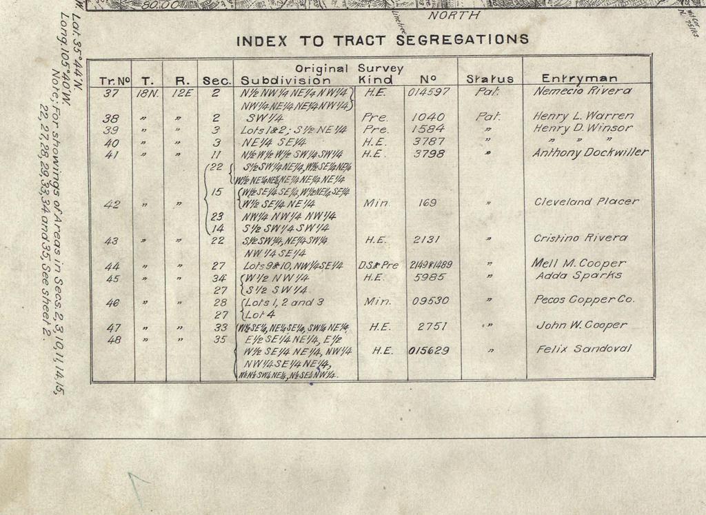
37 INCONSISTENCIES ON THE FACE OF THE PLAT Topographic features are not properly located on the original plat.
38
39 Original Plat
40 Ø Beard relied on a survey by Friel which located the S½S½ Sec. 16 approximately ½ mile south and ¼ mile west of the true position as determined by reference to corners of the original survey. J. M. BEARD (ON REHEARING) 52 L.D. 451 Ø In 1905 A.G. Strain purchased the S½S½ Sec. 16 from the State of California and later transferred the tract to J.M. Beard. Ø Beard instituted a suit to recover land occupied by the West Fork Ranger Station of the U.S. Forest Service.
41 Original 1875 Survey By Norway
42 1884 Completion Survey By Pearson


43 1926 Dependent Resurvey by Averill and Wilson S½S½
44 J. M. BEARD (ON REHEARING) 52 L.D. 451 Under the circumstances there appears li<le jus>fica>on for counsel's conten>on that items of topography, the posi>ons of which in the interior No of such sec>on importance were based has solely been upon attached an es>mate to or items guess of on topography the part of the by surveyor, the General and the Land record Office, distances the to Department, which on the or sec>on the Federal lines were courts. dependent upon the recollec>ons of the chainmen, and which were noted as ma<ers of useful informa>on or likely to gra>fy public curiosity, should therealer be accorded the dignity of natural monuments to which both courses and distances must give way.

45 Original Plat Rivera Patent
46 Independent Resurvey Plat Recovered Original Corner Original Section Lines
47 Independent Resurvey Plat Recovered Original Corner Original Section Lines
48
49 BLM argued that: Ø there was no confusion regarding the location of the patented land when it was resurveyed in 1925; Ø the portion of Lot 10 sought by the Lawsons has always been outside of the Rivera homestead; Ø the 12 acres in Lot 10 had not mistakenly been excluded from the original patent, noting that the homestead tract would be significantly distorted if this tract had been included; Ø they were not convinced that Rivera had relied upon the improvements on Lot 10 to support his patent, that the house used for proof of homestead was more likely to have been a house located on the patented homestead; Ø there was no mention of a cabin or stone cellar in the homestead entry file. Ø the Pecos river is a Wild and Scenic River.
50 IBLA Ruled: Ø Lot 10 is owned by the United States. The Lawsons do not dispute this fact; Ø The question now before us is whether the land in Lot 10 was erroneously excluded from the 1888 patent. Ø we must initially determine whether the evidence supports a finding that Rivera intended to claim land in Lot 10 when he made his homestead entry; Ø BLM holds the discretionary authority to correct patents of public land to eliminate mutual mistakes of fact as to description of land conveyed by the patent document; Ø The party applying for amendment must demonstrate an error in the description of the land in the patent which results in the inclusion of land the patentee and the United States had not intended to be conveyed and/or excludes land the
51 The Board s Decision: Ø The most compelling evidence of the intent of the parties is found on the face of the 1883 survey plat. Ø In Foust, Val Snow, and Hancock, there was sufficient evidence that the original patent failed to include land and improvements which the patentee and the United States intended to be included in the patent. The common thread in each of these cases was the evidence that the entryman had used the improvements to support the entry. Ø Additional evidence was submitted through sworn affidavits executed by Ramona Lawson. Ø Tree ring analysis of the logs in the house on lot 10, concluded that the cabin was built in 1882 or very soon thereafter.
52 Balancing the interests of the parties, we find that the equities clearly fall in favor of correcting the patent to include the lands that the homesteader sought and the Government intended to convey in 1888 and which were occupied by the homesteader and his heirs for over 120 years.
BOUNDARY SURVEYS RE-SURVEYS
 BOUNDARY SURVEYS RE-SURVEYS One of the difficult tasks for a surveyor is the re-surveying of lands, the re-location of the boundary lines between privately-owned lands or the re-location of the boundary
Group Break Out. What, if anything, sends up a red flag? What does the lotting along the North and South centerline suggest? What are your next steps?
 What is the NW ¼? What is the NW ¼? You are hired to survey your client s property in Section 8. His deed says NW ¼ Section 8, T. 40 S., R. 07 E. According to the county, it is Tax Lot 700. He gives you
P.F. WOOD, APPELLANT, V. C. MANDRILLA, RESPONDENT. SAC. NO SUPREME COURT
 Supreme Court of California,Department Two. 167 Cal. 607 {Cal. 1914) WOOD V. MANDRILLA P.F. WOOD, APPELLANT, V. C. MANDRILLA, RESPONDENT. SAC. NO. 2089. SUPREME COURT OF CALIFORNIA,DEPARTMENT TWO. APRIL
Center of Section. Computed or Monumented Position. Review and Commentary
 Center of Section Computed or Monumented Position Review and Commentary Center of Section Center of section defined by law for more than 200 years Computed position vs monumented position Examine the state
Requirements For All Instruments of Conveyance In Monroe County, Ohio. Transfer and Conveyance Standards of the Monroe County Auditor & Engineer
 Requirements For All Instruments of Conveyance In Monroe County, Ohio Transfer and Conveyance Standards of the Monroe County Auditor & Engineer Effective November 8, 2013 1 TRANSFER PROCEDURES FOR MONROE
Certified Federal Surveyor Program Assignment #3, Feedback
 Certified Federal Surveyor Program Assignment #3, Feedback Now that you have completed Assignment #3, take a few minutes to review the comments below. We have tried to identify items of special importance,
Certified Federal Surveyor Program Assignment #6, Feedback
 Certified Federal Surveyor Program Assignment #6, Feedback Now that you have completed Assignment #6, take a few minutes to review the comments below. We have tried to identify items of special importance,
WYANDOT COUNTY BASIC STANDARDS FOR THE APPROVAL OF REAL ESTATE DEED TRANSFERS & LAND CONTRACT AGREEMENTS
 GENERAL In compliance with Section 315.251 of the Ohio Revised Code, the County Auditor and the County Engineer have adopted these written standards governing the conveyance of real property in Wyandot
Preparing Property descriptions D A V I D T. BUTCHER, PLS
 Preparing Property descriptions D A V I D T. BUTCHER, PLS Who can prepare property descriptions? 327.272. Practice as professional land surveyor defined. 1. A professional land surveyor shall include any
APPROVAL REQUIREMENTS
 APPROVAL REQUIREMENTS FOR INSTRUMENTS OF CONVEYANCE IN ERIE COUNTY, OHIO DRAFT Requirements for all instruments of Conveyance in Erie County, revised and effective, 2014. An Erie County policy governing
STANDARDS GOVERNING CONVEYANCES OF REAL PROPERTY
 STANDARDS GOVERNING CONVEYANCES OF REAL PROPERTY Hancock County, Ohio Charity A. Rauschenberg, Hancock County Auditor Steven C. Wilson, Hancock County Engineer Revised: March 1, 2007 TRANSFER AND CONVEYANCE
Requirements for All Instruments of Conveyance in Logan County, Ohio
 Requirements for All Instruments of Conveyance in Logan County, Ohio Effective Date: April 11, 1997 It is the intent of these requirements to provide a standard method of checking legal descriptions for
William S. Graessle of William S. Graessle, P.A., Jacksonville, for Appellees. In this eminent domain action, the JEA appeals a final order awarding
 IN THE DISTRICT COURT OF APPEAL FIRST DISTRICT, STATE OF FLORIDA JEA, A BODY POLITIC AND CORPORATE OF THE STATE OF FLORIDA, NOT FINAL UNTIL TIME EXPIRES TO FILE MOTION FOR REHEARING AND DISPOSITION THEREOF
STANDARDS GOVERNING CONVEYANCES OF REAL PROPERTY IN DARKE COUNTY, OHIO
 STANDARDS GOVERNING CONVEYANCES OF REAL PROPERTY IN DARKE COUNTY, OHIO As directed by Section 319.203 of the Ohio Revised Code which states The County Auditor and the County Engineer shall adopt standards
CFedS Outline Unit 1. Course 1: History, Records & Administrative Systems
 CFedS Outline Unit 1 Course 1: History, Records & Administrative Systems History of U.S. Surveying Historical Perspective Similarities in Surveying Seniority of Calls Lack of Standards A National Debt
JAMES R. BIERSACK IBLA
 JAMES R. BIERSACK IBLA 88-260 Decided January 29, 1991 Appeal from separate decisions of the Eastern States Office, Bureau of Land Management, rejecting applications filed under the O'Konski Act (ES 35936),
CONFLICTING ELEMENTS
 CONFLICTING ELEMENTS Order of importance of conflicting elements that determine land location: A. Unwritten rights. B. Senior right. C. Written intentions of Parties. D. Lines Marked and Run. E. Natural
Transfer and Conveyance Standards of the Athens County Auditor and the Athens County Engineer. Table of Contents
 Transfer and Conveyance Standards of the Athens County Auditor and the Athens County Engineer Table of Contents Adoption of Standards Governing Conveyances of Real Property in Athens County, Ohio... 3
IN THE COURT OF APPEAL OF THE STATE OF CALIFORNIA THIRD APPELLATE DISTRICT. (Calaveras) ----
 ----") Filed 8/12/08 CERTIFIED FOR PUBLICATION IN THE COURT OF APPEAL OF THE STATE OF CALIFORNIA THIRD APPELLATE DISTRICT (Calaveras) ---- ALAN W. CLAUDINO, Plaintiff and Respondent, C054808 (Super. Ct. No. CV31806)
Filed 8/12/08 CERTIFIED FOR PUBLICATION IN THE COURT OF APPEAL OF THE STATE OF CALIFORNIA THIRD APPELLATE DISTRICT (Calaveras) ---- ALAN W. CLAUDINO, Plaintiff and Respondent, C054808 (Super. Ct. No. CV31806)
Standards for All Instruments of Conveyance
 Standards for All Instruments of Conveyance Perry County, Ohio Effective Date: May 1, 1997 Effective Date of Revision: April 1, 2011 Page 2 of 12 Minimum Standards for all Instruments of Conveyance Perry
ENTRY ORDER SUPREME COURT DOCKET NO JULY TERM, 2018
 Note: In the case title, an asterisk (*) indicates an appellant and a double asterisk (**) indicates a crossappellant. Decisions of a three-justice panel are not to be considered as precedent before any
610 LAND DIVISIONS AND PROPERTY LINE ADJUSTMENTS OUTSIDE A UGB
 ARTICLE VI: LAND DIVISIONS AND PROPERTY LINE ADJUSTMENTS VI-21 610 LAND DIVISIONS AND PROPERTY LINE ADJUSTMENTS OUTSIDE A UGB 610-1 Property Line Adjustments (Property Line Relocation) A property line
To provide for the review of the final engineering plans, the subdivision improvement agreement, public dedications, and other legal agreements.
 ARTICLE 5 FINAL PLAT 501 Intent DOUGLAS COUNTY SUBDIVISION RESOLUTION To provide for the review of the final engineering plans, the subdivision improvement agreement, public dedications, and other legal
Waterfront Titles in Washington
 Waterfront Titles in Washington WLTA Education Seminar Lynnwood, Washington October 20, 2012 George Peters Disclaimer: When in comes to water and title insurance the operative term is: CYA Control your
REQUIREMENTS FOR ALL INSTRUMENTS OF CONVEYANCE IN HARDIN COUNTY, OHIO
 REQUIREMENTS FOR ALL INSTRUMENTS OF CONVEYANCE IN HARDIN COUNTY, OHIO Effective Date: Michael L. Smith, P.E., P.S. Hardin County Engineer Michael T. Bacon Hardin County Auditor 1 I. GENERAL In compliance
GENERAL ASSEMBLY OF NORTH CAROLINA SESSION 2015 S 1 SENATE BILL 460. Short Title: Real Prop./Error Correction & Title Curative.
 GENERAL ASSEMBLY OF NORTH CAROLINA SESSION 0 S SENATE BILL 0 Short Title: Real Prop./Error Correction & Title Curative. (Public) Sponsors: Referred to: Senator Daniel (Primary Sponsor). Rules and Operations
RESTORATION OF LOST OR OBLITERATED CORNERS & SUBDIVISION OF SECTIONS a guide for surveyors
 DISCLAIMER The following is a retyped electronic version of "RESTORATION OF LOST OR OBLITERATED CORNERS AND SUBDIVISION SECTIONS", a supplement to the Manual of Surveying Instructions, designed to be word
OFFICIAL RULES OF THE COOK COUNTY ASSESSOR
 The Cook County Assessor s Rules provide requirements, parameters and guidance to persons doing business with the Assessor. Taxpayer assistance will be provided to individuals by Assessor personnel during
ORDINANCE NO OA
 ORDINANCE NO. 2013 11-OA AN ORDINANCE OF THE TOWNSHIP OF BERKELEY, COUNTY OF OCEAN, STATE OF NEW JERSEY, AMENDING THE TOWNSHIP CODE OF THE TOWNSHIP OF BERKELEY, SO AS TO CREATE ARTICLE XX, ENTITLED VOLUNTARY
Methods of Legal Description. Deeds and Land Descriptions. Government Survey (PLSS)
") Deeds and Land Descriptions Methods of Legal Description Government survey (PLSS): boundaries identified relative to rectangular national grid as established by 1785 Act of Congress Metes and bounds: boundaries
Deeds and Land Descriptions Methods of Legal Description Government survey (PLSS): boundaries identified relative to rectangular national grid as established by 1785 Act of Congress Metes and bounds: boundaries
DUSTY RHODES HAMILTON COUNTY AUDITOR WILLIAM W. BRAYSHAW HAMILTON COUNTY ENGINEER
 DUSTY RHODES HAMILTON COUNTY AUDITOR www.hamiltoncountyauditor.org WILLIAM W. BRAYSHAW HAMILTON COUNTY ENGINEER www.hamilton-co.org/engineer As Adopted Under Ohio Revised Code Section 319.203 Effective
TRANSFER PROCEDURES FOR WASHINGTON COUNTY, OHIO
 TRANSFER PROCEDURES FOR WASHINGTON COUNTY, OHIO The following requirements are adopted and established in conjunction with the Washington County Engineer and the Washington County Auditor as prescribed
Methods of Legal Description Metes and Bounds The Rectangular Survey System Recorded Plat Method Describing Elevation
 9 Legal Descriptions Methods of Legal Description Metes and Bounds The Rectangular Survey System Recorded Plat Method Describing Elevation METHODS OF LEGAL DESCRIPTION There are many common ways of describing
Oakland County Michigan Register of Deeds Plat Engineering, GIS, & Remonumentation Dept. Ph: (248) Fax (248)
 Fax (248)") Oakland County Michigan Register of Deeds Plat Engineering, GIS, & Remonumentation Dept. Ph: (248)-858-1447 Fax (248)-858-7466 Requirements Needed for Final Plat Approval No. General Requirements. 1 Routing
Oakland County Michigan Register of Deeds Plat Engineering, GIS, & Remonumentation Dept. Ph: (248)-858-1447 Fax (248)-858-7466 Requirements Needed for Final Plat Approval No. General Requirements. 1 Routing
MINOR PLAT FILING APPLICATION
 FILING APPLICATION Date of PC Meeting: Date of BCC Meeting: Fee Paid: 1. APPLICANT: DAYTIME PHONE: MAILING ADDRESS: LANDOWNER: DAYTIME PHONE: MAILING ADDRESS: AUTHORIZED AGENT: MAILING ADDRESS: RELATIONSHIP
Hoiska v. Town of East Montpelier ( ) 2014 VT 80. [Filed 18-Jul-2014]
![Hoiska v. Town of East Montpelier ( ) 2014 VT 80. [Filed 18-Jul-2014]](/thumbs/94/121069587.jpg "Hoiska v. Town of East Montpelier ( ) 2014 VT 80. [Filed 18-Jul-2014]") Hoiska v. Town of East Montpelier (2013-274) 2014 VT 80 [Filed 18-Jul-2014] NOTICE: This opinion is subject to motions for reargument under V.R.A.P. 40 as well as formal revision before publication in
Hoiska v. Town of East Montpelier (2013-274) 2014 VT 80 [Filed 18-Jul-2014] NOTICE: This opinion is subject to motions for reargument under V.R.A.P. 40 as well as formal revision before publication in
LEGAL DESCRIPTIONS A PRACTICAL GUIDE
 Sponsored by: LEGAL DESCRIPTIONS A PRACTICAL GUIDE Jerry Morris Grab Tab Handouts 1 Can t Hear Through Your Computer Speakers? Telephone Dial-in (XXX) XXX-XXXX Access Code: XXX-XXX-XXX Audio PIN: Check
BUREAU OF LAND MANAGEMENT. Fractional Sections. With John Farnsworth and Belle Craig C A D A S T R A L S U R V E Y
 BUREAU OF LAND MANAGEMENT Fractional Sections With John Farnsworth and Belle Craig 2009 C A D A S T R A L S U R V E Y Fractional Sections There are two types of fractional sections referenced in the 1973
Request for Action form is also defined as an application to be considered by the Planning Commission.
 CITY OF NORTH RIDGEVILLE INSTRUCTIONS FOR FILING REQUEST FOR ACTION APPLICATIONS WITH THE PLANNING COMMISSION (Please read the full instruction as it will help in providing a full complete application)
Subdivision of Fractional Sections ISPLS 2017
 Subdivision of Fractional Sections ISPLS 2017 Dennis J. Mouland, PLS Instructor Witness Tree Consulting, Inc., 2011, All Rights Reserved Course Objectives Understand the definition of a fractional section
OTTAWA COUNTY LEGAL DESCRIPTION REVIEW GUIDELINES
 OTTAWA COUNTY LEGAL DESCRIPTION REVIEW GUIDELINES APPROVED BY: RONALD P. LAJTI, JR., P.E., P.S. OTTAWA COUNTY ENGINEER APPROVED BY: LAWRENCE HARTLAUB OTTAWA COUNTY AUDITOR EFFECTIVE DATE: January 1, 2017
Reg. Section 15a.453-1(c)(2) Installment method reporting for sales of real property and casual sales of personal property
(2) Installment method reporting for sales of real property and casual sales of personal property") CLICK HERE to return to the home page Reg. Section 15a.453-1(c)(2) Installment method reporting for sales of real property and casual sales of personal property... (c)contingent payment sales. (1)In general.
CLICK HERE to return to the home page Reg. Section 15a.453-1(c)(2) Installment method reporting for sales of real property and casual sales of personal property... (c)contingent payment sales. (1)In general.
Delaware County Transfer Standards
 Delaware County Transfer Standards Delaware County Auditor David A. Yost Delaware County Engineer Chris Bauserman Adopted in 1997, Amended in 1999 Dave Yost County Auditor Chris Bauserman County Engineer
NORTH CAROLINA PROPERTY MAPPERS ASSOCIATION SECTION 6 PUBLIC LANDS
 NORTH CAROLINA PROPERTY MAPPERS ASSOCIATION SECTION 6 PUBLIC LANDS 6-1 6.1 Introduction Following our independence from England, the Congress in 1783 of the newly formed United States of America was faced
Lake County, Ohio USA
 Lake County, Ohio USA Christoper A. Galloway Lake County Auditor TRANSFER AND CONVEYANCE STANDARDS OF THE LAKE COUNTY AUDITOR AND THE LAKE COUNTY ENGINEER ADOPTED PURSUANT TO OHIO REVISED CODE SECTION
ARTICLE III GENERAL PROCEDURES, MINOR PLANS AND FEE SCHEDULES
 ARTICLE III GENERAL PROCEDURES, MINOR PLANS AND FEE SCHEDULES 301. Prior to Submission a. Copies of this Ordinance shall be available on request, at cost, for the use of any person who desires information
WESTON COUNTY FINAL PLAT APPLICATION
 WESTON COUNTY FINAL PLAT APPLICATION Property Owner: Mailing Address of owner: Telephone Number(s) of owner: Property Owner: Mailing Address of owner: Telephone Number(s) of owner: (If subdivider/applicant
ARTICLE XXVI. TRANSFER OF DEVELOPMENT RIGHTS (TDR) SECTION PURPOSE
 SECTION PURPOSE") ARTICLE XXVI. TRANSFER OF DEVELOPMENT RIGHTS (TDR) SECTION 2601. PURPOSE Within the Township, there are certain areas that, because of their unique natural, agricultural, cultural, and scenic resources,
ARTICLE XXVI. TRANSFER OF DEVELOPMENT RIGHTS (TDR) SECTION 2601. PURPOSE Within the Township, there are certain areas that, because of their unique natural, agricultural, cultural, and scenic resources,
Present: Carrico, C.J., Compton, Stephenson, Whiting, 1 Hassell, and Keenan, JJ.
 Present: Carrico, C.J., Compton, Stephenson, Whiting, 1 Hassell, and Keenan, JJ. Lacy, RICHARD F. DAVIS, ET AL. v. Record No. 941971 OPINION BY JUSTICE ELIZABETH B. LACY September 15, 1995 JOHN T. HENNING,
Collateral Evidence Analysis
 Wisconsin Society of Land Surveyors 2019 Surveyors Institute Wisconsin Dells, Wisconsin January 24, 2019 Collateral Evidence Analysis Stanley French Chief Cadastral Surveyor for Idaho (retired) Land Boundary
CITY OF LEE S SUMMIT MINOR PLAT PROCESS. Purpose of Minor Plats
 MINOR PLAT PROCESS Purpose of Minor Plats The City of Lee s Summit requires that all property be platted before a building permit is issued. Platting involves the subdivision of land into lots or tracts.
IN THE SUPREME COURT OF FLORIDA
 IN THE SUPREME COURT OF FLORIDA RICHARD KEITH MARTIN, ROBERT DOUGLAS MARTIN, MARTIN COMPANIES OF DAYTONA BEACH, MARTIN ASPHALT COMPANY AND MARTIN PAVING COMPANY, Petitioners, CASE NO: 92,046 vs. DEPARTMENT
LEGAL ASPECTS OF LAND SURVEYING
 LEGAL ASPECTS OF LAND SURVEYING By: Dr. Tony Nettleman Copyright Nettleman Land Surveying, INC (2016) Fig: Welcome Picture YOUR SPEAKER Surveying All My Life Began Working with Attorneys Went to College
UTAH COUNCIL OF LAND SURVEYORS STANDARDS OF PRACTICE FOR BOUNDARY SURVEYS
 UTAH COUNCIL OF LAND SURVEYORS STANDARDS OF PRACTICE FOR BOUNDARY SURVEYS By the Utah Council of Land Surveyors Committee on Boundary Survey Standards Adopted by the Utah Council of Land Surveyors Executive
Assessment-To-Sales Ratio Study for Division III Equalization Funding: 1999 Project Summary. State of Delaware Office of the Budget
 Assessment-To-Sales Ratio Study for Division III Equalization Funding: 1999 Project Summary prepared for the State of Delaware Office of the Budget by Edward C. Ratledge Center for Applied Demography and
IN THE COMMONWEALTH COURT OF PENNSYLVANIA
 IN THE COMMONWEALTH COURT OF PENNSYLVANIA Gregory J. Rubino and : Lisa M. Rubino, : Appellants : : v. : No. 1015 C.D. 2013 : Argued: December 9, 2013 Millcreek Township Board : of Supervisors : BEFORE:
Borowski v. STEWART TITLE GUARANTY COMPANY, Wis: Court of Appeals, 1st...
 Page 1 of 5 JOHN BOROWSKI, PLAINTIFF-APPELLANT, v. STEWART TITLE GUARANTY COMPANY, DEFENDANT-RESPONDENT. Appeal No. 2013AP537. Court of Appeals of Wisconsin, District I. Filed: December 27, 2013. Before
H.R. 2157, to facilitate a land exchange involving certain National Forest System lands in the Inyo National Forest, and for other purposes.
 STATEMENT OF GREGORY SMITH ACTING DEPUTY CHIEF OF STAFF UNITED STATES DEPARTMENT OF AGRICULTURE BEFORE THE UNITED STATES HOUSE OF REPRESENTATIVES COMMITTEE ON NATURAL RESOURCES SUBCOMMITTEE ON NATIONAL
COPYRIGHTED MATERIAL HOW BOUNDARIES ARE CREATED CHAPTER INTRODUCTION
 CHAPTER 2 HOW BOUNDARIES ARE CREATED 2.1 INTRODUCTION To understand the legal fiction of boundaries, the surveyor must be able to make a distinction between the various elements of corners, monuments,
ADAMS V. BLUMENSHINE, 1922-NMSC-010, 27 N.M. 643, 204 P. 66 (S. Ct. 1922) ADAMS et al. vs. BLUMENSHINE
 ADAMS et al. vs. BLUMENSHINE") 1 ADAMS V. BLUMENSHINE, 1922-NMSC-010, 27 N.M. 643, 204 P. 66 (S. Ct. 1922) ADAMS et al. vs. BLUMENSHINE No. 2646 SUPREME COURT OF NEW MEXICO 1922-NMSC-010, 27 N.M. 643, 204 P. 66 January 13, 1922 Appeal
1 ADAMS V. BLUMENSHINE, 1922-NMSC-010, 27 N.M. 643, 204 P. 66 (S. Ct. 1922) ADAMS et al. vs. BLUMENSHINE No. 2646 SUPREME COURT OF NEW MEXICO 1922-NMSC-010, 27 N.M. 643, 204 P. 66 January 13, 1922 Appeal
IN THE COMMONWEALTH COURT OF PENNSYLVANIA
 IN THE COMMONWEALTH COURT OF PENNSYLVANIA David Raup, No. 237 C.D. 2014 Appellant Argued December 10, 2014 v. Dauphin County Board of Assessment Appeals, Dauphin County, The Borough of Paxtang and the
Rule 21 STANDARDS OF PRACTICE FOR SURVEYING
 Rule 21 STANDARDS OF PRACTICE FOR SURVEYING 21.1 Whenever a survey is performed, it shall comply with Section 73-13-71 (4) and Section 73-13- 73 and the Standards of Practice for Surveying in Mississippi
Natural Resources Assistance Council DISTRICT 12 - LUCAS COUNTY, OHIO
 Natural Resources Assistance Council DISTRICT 12 - LUCAS COUNTY, OHIO Program Eligibility Application Information Sheet Any local political subdivision or any non-profit organization within District 12
IN THE SUPREME COURT OF FLORIDA CASE NO. SC11-765
 IN THE SUPREME COURT OF FLORIDA CASE NO. SC11-765 AL-NAYEM INTER L INCORPORATED Plaintiff/Petitioner, vs. EDWARD J. ALLARD, Defendant/Respondent. PETITIONER S BRIEF ON JURISDICTION SECOND DISTRICT CASE
WHATCOM COUNTY HEARING EXAMINER SUMMARY OF APPEAL AND DECISION
 WHATCOM COUNTY HEARING EXAMINER RE: Administrative Appeal ) APL2010-0006 Application for ) ) FINDINGS OF FACT, Ron and Shelley Jepson ) CONCLUSIONS OF LAW, ) AND DECISION SUMMARY OF APPEAL AND DECISION
[Cite as Cambridge Commons Ltd. Partnership v. Guernsey Cty. Bd. of Revision, 106 Ohio St.3d 27, 2005-Ohio-3558.]
![[Cite as Cambridge Commons Ltd. Partnership v. Guernsey Cty. Bd. of Revision, 106 Ohio St.3d 27, 2005-Ohio-3558.]](/thumbs/90/102441641.jpg "[Cite as Cambridge Commons Ltd. Partnership v. Guernsey Cty. Bd. of Revision, 106 Ohio St.3d 27, 2005-Ohio-3558.]") [Cite as Cambridge Commons Ltd. Partnership v. Guernsey Cty. Bd. of Revision, 106 Ohio St.3d 27, 2005-Ohio-3558.] CAMBRIDGE COMMONS LIMITED PARTNERSHIP, APPELLANT, v. GUERNSEY COUNTY BOARD OF REVISION
[Cite as Cambridge Commons Ltd. Partnership v. Guernsey Cty. Bd. of Revision, 106 Ohio St.3d 27, 2005-Ohio-3558.] CAMBRIDGE COMMONS LIMITED PARTNERSHIP, APPELLANT, v. GUERNSEY COUNTY BOARD OF REVISION
CODE OF PRACTICE FOR LAND SURVEYORS
 CODE OF PRACTICE FOR LAND SURVEYORS PREPARED BY DELAWARE-HUDSON PROFESSIONAL LAND SURVEYORS ASSOCIATION P.O. BOX 502 HIGHLAND MILLS, NY 10930 ADOPTED DECEMBER 9, 1987 REVISED FEBRUARY 9, 1988 Preamble
A Bill Regular Session, 2017 HOUSE BILL 1454
 Stricken language would be deleted from and underlined language would be added to present law. 0 State of Arkansas st General Assembly A Bill Regular Session, HOUSE BILL By: Representative L. Fite For
Corner Evidence Analysis. Instructor: Dennis J. Mouland, PLS
 Corner Evidence Analysis Instructor: Dennis J. Mouland, PLS Witness Tree Consulting, Inc., 2011 Course Goals Corner Evidence Analysis We will.. 1. Review the need for evidence search 2. Review tools for
UNITED STATES DISTRICT COURT EASTERN DISTRICT OF WISCONSIN. Appellant/Defendant, v. Case No. 12-C Appellant/Defendant. Case No.
 UNITED STATES DISTRICT COURT EASTERN DISTRICT OF WISCONSIN CITY OF MILWAUKEE, Appellant/Defendant, v. Case No. 12-C-0728 RITA GILLESPIE, Appellee/Plaintiff. CITY OF MILWAUKEE, Appellant/Defendant. Case
Certiorari not Applied for COUNSEL
 1 SANDOVAL COUNTY BD. OF COMM'RS V. RUIZ, 1995-NMCA-023, 119 N.M. 586, 893 P.2d 482 (Ct. App. 1995) SANDOVAL COUNTY BOARD OF COMMISSIONERS, Plaintiff, vs. BEN RUIZ and MARGARET RUIZ, his wife, Defendants-Appellees,
(5) Multiple Transfer Fees collectively paid with one check will not be accepted.
 Multiple Transfer Fees collectively paid with one check will not be accepted.") TRANSFER AND CONVEYANCE STANDARDS OF THE FRANKLIN COUNTY AUDITOR AND THE FRANKLIN COUNTY ENGINEER AS ADOPTED UNDER OHIO REVISED CODE SECTION 319.203 EFFECTIVE JULY 1, 1996 AMENDED JULY 14, 1997 AMENDED
TRANSFER AND CONVEYANCE STANDARDS OF THE FRANKLIN COUNTY AUDITOR AND THE FRANKLIN COUNTY ENGINEER AS ADOPTED UNDER OHIO REVISED CODE SECTION 319.203 EFFECTIVE JULY 1, 1996 AMENDED JULY 14, 1997 AMENDED
IN THE COURT OF COMMON PLEAS CUYAHOGA COUNTY, OHIO
 IN THE COURT OF COMMON PLEAS CUYAHOGA COUNTY, OHIO NEWPORT HARBOR ASSOCIATION ) CASE NO. CV 11 755497 ) Appellant, ) JUDGE PAMELA A. BARKER ) v. ) JOURNAL ENTRY AND OPINION ) CUYAHOGA COUNTY BOARD OF )
RULES AND REGULATIONS FOR ADMINISTRATION OF AREA DRAINAGE PLANS
 RIVERSIDE COUNTY RULES AND REGULATIONS FOR ADMINISTRATION OF AREA DRAINAGE PLANS ADOPTED JUNE 10, 1980 BY RESOLUTION NO. 80-244 AMENDMENTS RESOLUTION NO. May 26, 1981 81-148 Nov. 9, 1982 82-320 July 3,
NOT DESIGNATED FOR PUBLICATION STATE OF LOUISIANA COURT OF APPEAL, THIRD CIRCUIT consolidated with
 NOT DESIGNATED FOR PUBLICATION STATE OF LOUISIANA COURT OF APPEAL, THIRD CIRCUIT 14-1157 consolidated with 14-1158 STATE OF LOUISIANA, DEPT. OF TRANSPORTATION & DEVELOP. VERSUS KNOLL & DUFOUR LANDS, LLC
THE PURPOSE OF MEASUREMENTS IN BOUNDARY SURVEYS. (THE ETERNAL SUVRVEY QUESTION: HOW CLOSE IS CLOSE ENGOUGH?) By. Norman Bowers, P.S. & P.E.
 By. Norman Bowers, P.S. & P.E.") THE PURPOSE OF MEASUREMENTS IN BOUNDARY SURVEYS (THE ETERNAL SUVRVEY QUESTION: HOW CLOSE IS CLOSE ENGOUGH?) By Norman Bowers, P.S. & P.E. Steven S. Brosemer, P.S. Figure 1 Surveyors are all about measurements.
THE PURPOSE OF MEASUREMENTS IN BOUNDARY SURVEYS (THE ETERNAL SUVRVEY QUESTION: HOW CLOSE IS CLOSE ENGOUGH?) By Norman Bowers, P.S. & P.E. Steven S. Brosemer, P.S. Figure 1 Surveyors are all about measurements.
Nassau County Single Land Split Application
 NASSAU COUNTY DEPARTMENT OF PLANNING AND ECONOMIC OPPORTUNITY FLORIDA Nassau County Single Land Split Application Taco E. Pope, AICP, Director 96161 Nassau Place Yulee, Florida 32097 (904) 530-6300 APPLICATION
GENERAL. All authors of conveyance instruments are encouraged to contact the County Auditor s Office well in advance of transfer.
 GENERAL In accordance with Section 319.203 of the Ohio Revised Code, the Geauga County Auditor and the Geauga County Engineer, by agreement, hereby establish the following standards governing the conveyance
(Proceeding No. 1.) MEMORANDUM AND ORDER
 MEMORANDUM AND ORDER") Decided and Entered: April 25, 2002 90621 In the Matter of ULSTER BUSINESS COMPLEX LLC, Appellant, V TOWN OF ULSTER et al., Respondents. (Proceeding No. 1.) MEMORANDUM AND ORDER In the Matter of AG PROPERTIES
Decided and Entered: April 25, 2002 90621 In the Matter of ULSTER BUSINESS COMPLEX LLC, Appellant, V TOWN OF ULSTER et al., Respondents. (Proceeding No. 1.) MEMORANDUM AND ORDER In the Matter of AG PROPERTIES
Concerns about Methodology
 1979 NDSPLS ADMINISTRATIVE OFFICE PO Box 7370 Bismarck, ND 58507 Phone: 701-223-3184 E-mail: info@ndspls.org Website: www.ndspls.org North Dakota Industrial Commission Department of Mineral Resources Lynn
STATE OF MICHIGAN COURT OF APPEALS
 STATE OF MICHIGAN COURT OF APPEALS FRANK J. NOA, Plaintiff-Appellee, UNPUBLISHED October 13, 2005 v No. 255310 Otsego Circuit Court AGATHA C. NOA, ESTATE OF MICHAEL J. LC No. 03-010202-CH NOA and M&M ENTERPRIZES,
Minor Subdivision Application
 FOR PLANNING USE ONLY Application # SD Application Fee $1,000.00 Receipt No. Filing Date Completeness Date Minor Subdivision Application A. PROJECT INFORMATION 1. Project Name: 2. Address of Subject Property:
GENERAL ASSEMBLY OF NORTH CAROLINA SESSION 2017 H 1 HOUSE BILL 454* Short Title: Surveying and Plat Recording Changes. (Public)
") GENERAL ASSEMBLY OF NORTH CAROLINA SESSION H 1 HOUSE BILL * Short Title: Surveying and Plat Recording Changes. (Public) Sponsors: Referred to: Representative Arp. For a complete list of sponsors, refer
GENERAL ASSEMBLY OF NORTH CAROLINA SESSION H 1 HOUSE BILL * Short Title: Surveying and Plat Recording Changes. (Public) Sponsors: Referred to: Representative Arp. For a complete list of sponsors, refer
LONDON LIFE INSURANCE CO. ASSESSOR OF AREA 9 -- VANCOUVER. Supreme Court of British Columbia (A872713) Vancouver Registry
 Vancouver Registry") The following version is for informational purposes only, for the official version see: http://www.courts.gov.bc.ca/ for Stated Cases see also: http://www.assessmentappeal.bc.ca/ for PAAB Decisions SC
The following version is for informational purposes only, for the official version see: http://www.courts.gov.bc.ca/ for Stated Cases see also: http://www.assessmentappeal.bc.ca/ for PAAB Decisions SC
Conveyance Standards. Boundary Survey Requirements. Adams County, Ohio
 Conveyance Standards And Boundary Survey Requirements Adams County, Ohio OFFICE OF THE ADAMS COUNTY AUDITOR DAVID GIFFORD 110 WEST MAIN STREET WEST UNION, OH 45693 OFFICE OF THE ADAMS COUNTY ENGINEER DAVID
JOSEPH TOMALINO AUGUST SOBOTKA IBLA
 JOSEPH TOMALINO AUGUST SOBOTKA Decided August 16, 1979 Appeal from a decision of the Chief, Division of Cadastral Survey, Bureau of Land Management, dismissing appellants' protest against a proposed public
City of Fort Lupton Amended Plat Process
 City of Fort Lupton Amended Plat Process Purpose The Amended Plat process is an administrative process to amend a recorded Plat. An Amended Subdivision is an administrative revision to a recorded Subdivision
House Joint Resolution 1
 th OREGON LEGISLATIVE ASSEMBLY--0 Regular Session House Joint Resolution Introduced and printed pursuant to House Rule.00. Presession filed (at the request of House Interim Committee on Revenue) SUMMARY
STATE OF CALIFORNIA AUTHENTICATED ELECTRONIC LEGAL MATERIAL. State of California GOVERNMENT CODE. Section 65915
 STATE OF CALIFORNIA AUTHENTICATED ELECTRONIC LEGAL MATERIAL State of California GOVERNMENT CODE Section 65915 65915. (a) When an applicant seeks a density bonus for a housing development within, or for
JOINT PLANNING BOARD APPLICATION FORM
 JOINT PLANNING BOARD APPLICATION FORM TOWNSHIP OF RIVER VALE 406 RIVERVALE ROAD RIVER VALE, NJ 07675 The application, with supporting documentation, must be filed with the Administrative Officer to the
19, 1988 WEATHERSBY GODBOLD CARTER RICHARD T. HARRISS, III IBLA
 Editor's note: Reconsideration denied by Order dated Jan. 19, 1988 WEATHERSBY GODBOLD CARTER RICHARD T. HARRISS, III Decided April 29, 1987 Appeal from a decision of the Eastern States Office, Bureau of
Supreme Court of Florida
 Supreme Court of Florida No. SC01-1459 PER CURIAM. ALLSTATE INSURANCE COMPANY, Petitioner, vs. LUIS SUAREZ and LILIA SUAREZ, Respondents. [December 12, 2002] We have for review the decision in Allstate
TOWN OF ROXBURY PLANNING BOARD
 UPDATED: APRIL 2011 TOWN OF ROXBURY PLANNING BOARD Applicant s Guide for Subdivision Review The Town Planning Board administers the subdivision review process. This guide has been prepared in order to
250 CMR: BOARD OF REGISTRATION OF PROFESSIONAL ENGINEERS AND LAND SURVEYORS DRAFT FOR DISCUSSION PURPOSES ONLY
 250 CMR 6.00: LAND SURVEYING PROCEDURES AND STANDARDS Section 6.01: Elements Common to All Survey Works 6.02: Survey Works of Lines Affecting Property Rights All land surveying work is considered work
STATE OF LOUISIANA COURT OF APPEAL, THIRD CIRCUIT ADMINISTRATORS OF VACANT SUCC. OF ISAAC J. CELESTINE, ET AL. **********
 STATE OF LOUISIANA COURT OF APPEAL, THIRD CIRCUIT 13-1453 CITY OF DERIDDER, LOUISIANA VERSUS ADMINISTRATORS OF VACANT SUCC. OF ISAAC J. CELESTINE, ET AL. ********** APPEAL FROM THE THIRTY-SIXTH JUDICIAL
STATE OF MICHIGAN COURT OF APPEALS
 STATE OF MICHIGAN COURT OF APPEALS LAKE FOREST PARTNERS 2, INC., Petitioner-Appellant, FOR PUBLICATION June 6, 2006 9:05 a.m. v No. 257417 Tax Tribunal DEPARTMENT OF TREASURY, LC No. 00-292089 Respondent-Appellee.
FINAL PLAT APPLICATION
 FINAL PLAT APPLICATION (Page 1 of 3) LEGAL OWNER(s): NAME: STREET ADDRESS OWNER(s): CITY, STATE, ZIP CODE: PHONE NUMBER: BILLING ADDRESS: NAME OF ENGINEER/SURVEYOR: Engineer/Surveyor Address, Phone: PROPERTY
Residential Density Bonus
 Chapter 27 Residential Density Bonus 27.010 Purpose and Intent This chapter is intended to provide incentives for the production of housing for Very Low, Lower Income, Moderate or Senior Housing in accordance
I. Requirements for All Applications. C D W
 108-16.1. Application checklists. Checklist for Required Submissions to the Planning Board or Zoning Board of Adjustment of Monroe Township All required submissions are to be made to the Administrative
CHAPTER 9.06 BOUNDARY LINE ADJUSTMENTS
 CHAPTER 9.06 BOUNDARY LINE ADJUSTMENTS SECTIONS: 9.06.010 Purpose 9.06.020 Applicability 9.06.030 Application 9.06.040 Plan For Boundary Line Adjustment 9.06.050 Criteria For Approval 9.06.060 Approval