Corner Evidence Analysis. Instructor: Dennis J. Mouland, PLS
|
|
|
- Rafe Campbell
- 6 years ago
- Views:
Transcription

1 Corner Evidence Analysis Instructor: Dennis J. Mouland, PLS Witness Tree Consulting, Inc., 2011
2 Course Goals Corner Evidence Analysis We will.. 1. Review the need for evidence search 2. Review tools for records research 3. Discuss uses of field evidence in corner point identification 4. Explore some keys to resolving conflicting evidence


3 The textbook:

4 A long history of Manuals Original contracts and instructions 1851 Oregon Instructions Full Manuals: Understand the relationship to previous Manuals

5 Common Law A system of jurisprudence based on custom, traditional usage, and precedent from previously heard cases, rather than a codified system of laws 5000 years of very consistent basics: Original point holds forever Natural monuments generally hold over others Intent of the parties Egyptian rope stretchers

6 Don t sell your professional soul ART Legal Research Records research Corner Search Evidence Analysis Unwritten rights Boundary law Title Issues SCIENCE Measurements Calculations Adjustments GPS-Geodesy AutoCAD, etc. The Professional Land Surveyor must be an expert in both areas.
 Halley v.")
7 Case Law The body of law based on judicial decisions, as distinguished from laws created by legislatures or Congress, the latter being known as statutory law. Case law is often considered part of the common law Survey-related case law very consistent; look these up some time: Vaught v. McClymond (155 P2d. 612 {1945}) Halley v. Harriman (183 NW 665 {1921}) State v. Ball (133 NW 412 {1911}) Puget Mill Co v. North Seattle Improvement Co. (206 P. 954 {1922})
8 Why does all this matter? Protect the plat is a concept GLO/BLM always held. Basics of protecting bona fide rights granted by patents. It comes from U.S. Supreme Court direction Means to uphold the factors given on the plat, including topography, intent, ratios and equities Our slogan will be: Always let the PLAT tell you what to do
9 Range Line What is a resurvey? Cragin v. Powell 128 U.S. 691 (1888) Chaos with erroneous resurveys A major issue for the modern surveyor How apply to the 1320 Club s actions? Use of topography ok Protect the plat not running the record Cragin Swamp land 5 miles +/-
10 Subdivisional Corners created? Yes, but not monumented: Not synonymous terms Corner is a point on the surface of the earth, a location Monument is a physical object claiming to be at a corner point
 Evidence search is NOT an option, nor a matter to be")
11 Puget Mill Co v. North Seattle Improvement Co. (206 P. 954 {1922}) Evidence search is NOT an option, nor a matter to be taken lightly
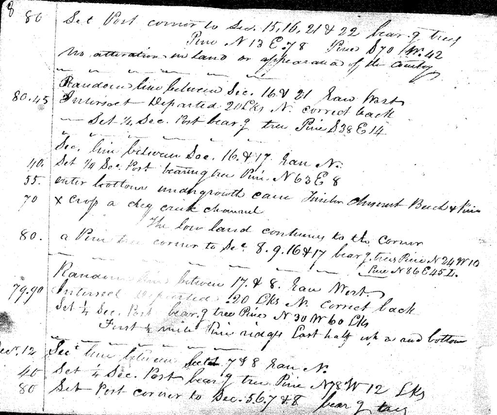
12 Fixed Forever? Without error and exact? A legal concept Not a math issue Basis of proportioning; hold the original intent Basis of a stable society is a set of stable boundaries Disputes arise due to interpretation of intent or due to conflicting intent
13 Boundary v. Property Line Sometimes these terms are confused For our purposes; Boundaries are original lines created by GLO Property lines start on these Property lines can move away from boundaries by actions or inactions of landowners or courts Boundaries stay fixed So what can the courts actually do? Fix the property line between the parties named Original Red is original boundary Green is occupation line +100 years
14 The Legal Pathway of Evidence Patent calls for the plat Plat calls for the notes Notes call for measurements and evidence on the ground Thus, every patent calls for monuments and other evidence on the ground to control its location How could you do a real survey without these records?
15 Pathway PATENT PLATS NOTES MONUMENTS Every PLSS parcel ultimately calls for monuments in the ground!
16 Researching the Record PRIMARY SOURCES GLO/BLM Notes County Records City State Special Districts NOAA Railroads Utilities Highway Departments Resource Mgt companies SECONDARY Title Companies Assessor s Offices GIS data Court Cases in area
17 Don t forget the other record Unrecorded plats, notes, and other documents of private surveyors Can you use them? Dealing with un-cooperative persons
18 Analyzing the private records Ideal Goal: Assemble the entire history of each corner and it s evidence thru time Watch for signs of poor surveys/dumb assumptions: , 660, Aliquot acreages 3. Bad proportions 4. Lack of evidence calls 5. Conversions to metes and bounds from PLSS

19 USGS Quads..
20 Getting the GLO/BLM Record Your only reliable source is the Public Room, a function of each BLM State Office Micro-filmed (through 1998) and/or scanned records are available of plats, notes, patents, and other records Go to for links to almost all survey records, and many Master Title Plats, Patents, and other Land Status information Many states have their own copies/sources
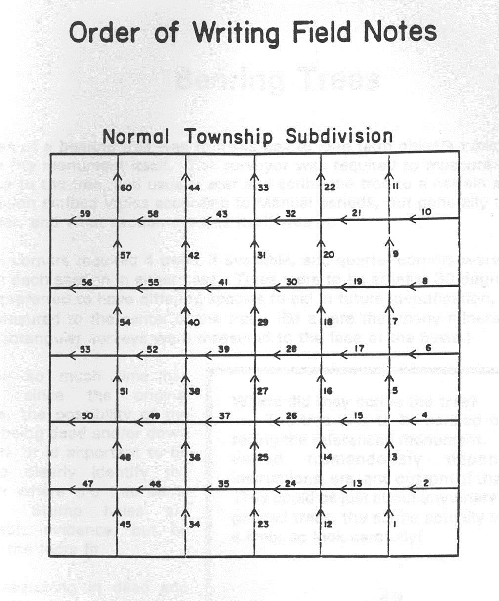
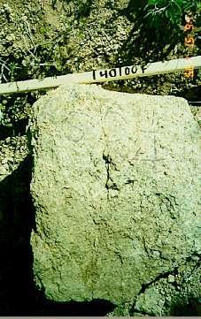
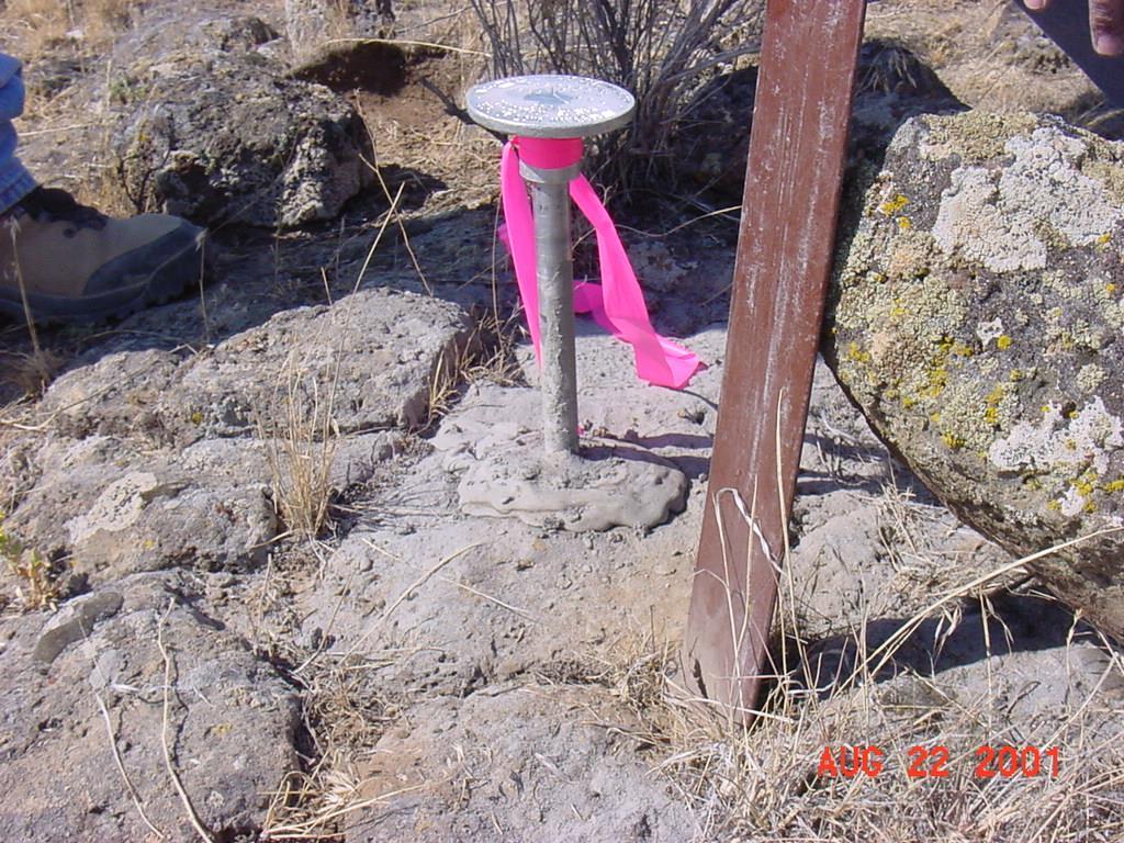
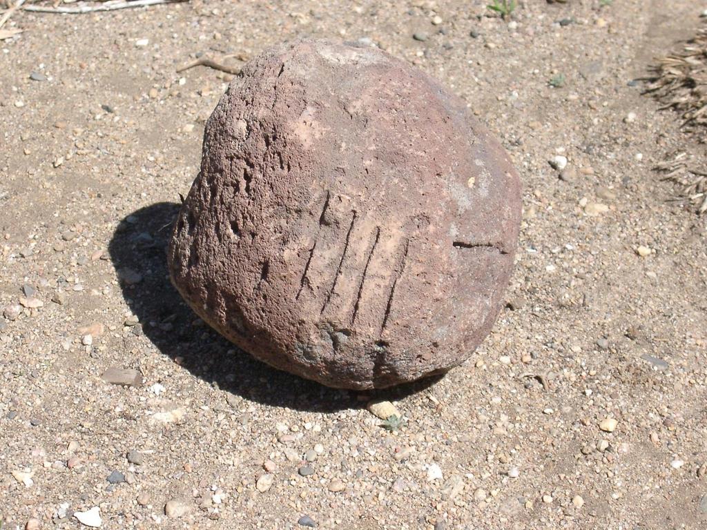
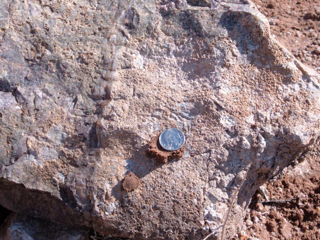
 Controlling Intermediate Corners may exist Topo calls and passing")
21 About the notes. Understand how running notes work Evidence calls (corners and accessories) Controlling Intermediate Corners may exist Topo calls and passing calls Other info in introductions, closing comments/certifications Transcribe older notes carefully!! Lots of info not on the plat
22

23 Running column in chains Topo Calls Corner and accessory descriptions
24

25 See Chapter 4 of Manual for current PLSS names and marks.

26 Corner Search Techniques What is your attitude? Avoid the surveys done in a bar theories Hate proportioning! Develop positive attitudes in your staff about finding evidence Be persistent Can you see the big picture?
27 Getting there. Old methods: Compass/pace or compass/string box Hope USGS quad is accurate Traverse in from known corners Watch for fences, other culture Newer methods: GPS in to search area Use GCDB data
 Trade areas if more than one person Look for ALL the evidence, not just your favorite or the")
28 Establish a Pattern Make your search comprehensive and thorough (avoid hit and miss searches) Set a pattern for search from a key location (grids, circles) Trade areas if more than one person Look for ALL the evidence, not just your favorite or the easiest

29 Look for ALL the evidence Monument Accessories Memorials Controlling Intermediate Corners Topo and passing calls Cultural feature ties
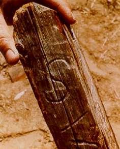
30 Monuments Wood posts Mounds and pits Stones Tree monument Iron post with brass cap Aluminum posts/drive monuments

31
32

33

34

35
36

37
38 Accessories Fixed physical objects tied by bearing and distance to a corner point Used as a system of RM s for the preservation of the corner location Includes memorials under a monument Includes some cultural feature ties made by the original surveyor Use = D-D unless only one, then go record B&D

39

40


41 Where were BT s marked? Just about anywhere Measured horizontally to center of tree, top of the root crown Bark scribe v. wood scribe

42

43
44 Using Topo Calls Not a black and white answer.. Every survey is unique so ask these questions: Were they faithfully measured? Were they faithfully recorded? Are they to the nearest chain or 10 links? Are they well-defined calls? Has the call moved or been altered?

45

46 Well-defined Water courses unable to move Roads Trails Ridges Cliffs Structures Types of topo calls Poorly defined Water courses that can move easily Begin Descent Enter swamp Leave meadow Enter wooded area
47 Concerns with topo calls 1. Accurately measured/reported? A. Make sense to themselves? B. Nothing major missing? 2. Taken on the random line? A. Not on the true line, not approved B. Can make adjustments to help search areas Random Line TRUE LINE

48 Still Looking for ALL the Evidence

49 Controlling Intermediate Corners Line trees Meander Corners (7-38) On-line Witness Corners Witness Points Closing Corners Crossing Closing Corners Previously set subdivisional corners
50 LT LT 1/4 Lost 1/4 WP WP RECORD MEASURED

51 Blazed Lines through timbered areas

52 Cultural Feature Ties Ties often from corners or as passing calls Cabins Fences Barns Well-defined and fixed? 3 chain rule Set corner. From which.. accessories, and then: The northeast corner of the Smith barn bears S12E, 1.65 chains dist.
53 What about far-away ties or calls? Long ties usually not measured or reliable Be cautious with evolving calls Mine shafts Springs Even structures!!

54 The Three Corner Conditions

55 Existent An existent corner is one whose original position can be identified by substantial evidence of the monument or its accessories, by reference to the description in the field notes, or located by an acceptable supplemental survey record, some physical evidence, or reliable testimony.
56 Obliterated An obliterated corner is an existent corner where, at the corner's original position, there are no remaining traces of the monument or its accessories but whose position has been perpetuated, or the point for which may be recovered, by substantial evidence from the acts or reliable testimony of the interested landowners, competent surveyors, other qualified local authorities, or witnesses, or by some acceptable record evidence.
57 Lost 7-2- A lost corner is one whose original position cannot be determined by substantial evidence, either from traces of the original marks or from acceptable evidence or reliable testimony that bears upon the original position, and whose location can be restored only by reference to one or more interdependent corners.
58 Witness Information (6-20) (Don t lead your witness) How do they know this is the corner? Was there a marker of some kind? If so, what was it? Were there any markings on it, and what were they? When did they first see it? When did they last see it? What aids them in knowing where it was? Mental accessories? Date of testimony Identity, address, etc

59 Evidence Reality Not fair to demand perfection of these surveyors or their evidence Perhaps the Deputy Surveyor was not: Measuring exact stone dimensions Aware of basic geology An expert on tree species Consistent from start to finish Careful in his notes Honest

60 Time and the Elements. Soft stones lose marks Wood rots Trees die or get cut People inadvertently destroy evidence Moss and lichen hide evidence Only accessories remain? Use them! Be realistic

61
62
63
64 Keys to conflicting evidence We cannot totally resolve all, but we can resolve MOST evidence confusion Usually lies in the notes: Transcribed notes Reversed numbers Transpositions Horiz v. Slope Wrong quadrants Or it lies in a field discrepancy Importance of working and thinking in the units of measure in the record

65 Let s look at 5 common questions Question 1: Where is the actual corner point when the stone does not have a + on it? ANSWER: The high point or center of the stone is considered the actual point. Most of the time, GLO did not set a mark; thus indicating a previous retracer placed it on the stone
66 Question 2 Question: What if two or more accessories indicate a different position than the monument? ANSWER: The validity of the monument needs to be established. It is possible the accessories are written wrong in the notes, but this usually indicates your corner mon has been disturbed, moved, or re-set by someone unauthorized to do so.
67 Question 3 Question: What if the monument is gone, but the accessories do not come to the same place? ANSWER: Examine the record closely, try every combo of transpositions, H v.s, wrong quadrants. If no D-D intersect, then one distance is bad. If no B-B intersect, then a bearing is bad. Closest is best?
68 Question 4 Question: Is it safe to set a corner from a single remaining accessory? ANSWER: Yes, but we should note a couple of concerns: 1. The reason you cannot find the mon or the other acc. could be due to this acc. having an error in a dimension 2. Use of one really requires some thought on Basis of Bearings and possible indexing

69 Question 5 Question: You have found the original stone in place, and the GLO BC from a dependent resurvey is right alongside it. Which is the corner? ANSWER: Read the record closely. If the cap setter said it was set at the corner point, we generally use the cap. Sometimes this can be disproved with the use of close and accurate accessories, but otherwise the cap is the policy in these cases


70 The Uncalled-for Monument We often find a monument not in any record. We must determine if it was: a faithful re-monumentation of the original a properly performed proportion to set a lost corner A bogus position set by someone as a best guess A lost corner now?
71 Uncalled-for vs. Obliterated Really one in the same in analysis Read 6-17 for clues as to how to assess it. Courts ask does it meet the intent of the parties? What would you say is the intent? Beware of doing a pass/fail on it solely by proportioning or math analysis


72 Local corner evidence analysis: The hardest part of the job What are your corner acceptance paradigms? Oldest? Rustiest? Most used? Biggest monument? Fits culture? Under your hat?
73 How long should you search? Age old question, but consider these points: Set time frames are foolish Exhaust the reasonable possibilities Identify who does the best corner search in your organization But the real key to finding evidence others do not find is..

74 How long should you search? If you have properly researched the record, and if you have a positive attitude about corner search, and if you use your common sense, you will find evidence the average surveyor never will!!
75 It s evidence, but is it proof? EVIDENCE - Writings, testimony, or material objects legally presentable at a trial, as a means to prove the existence or non-existence of a fact. PROOF - The effect of evidence, a mental conviction as to the truth or falsity of a proposition; the creation of a belief.

76 Basic Definitions Corner Monument Accessory Memorial Best available evidence Common report Hierarchy of evidence (bounds vs. metes)

77 Hierarchy of Evidence in Boundary Determination Natural Monuments Artificial Monuments Adjoiners Surveys Distances Bearings Area Coordinates

78 What does the LAW say? Statutes Regulations Case Law
79 What does the LAW say? The Court System: Where do we go for precedent setting cases? Equity vs. Precedent Most survey cases only heard by Judge Judy
80 State Court System Final Reviewing Court (Supreme Court) Intermediate Appellate Court (Court of Appeals) Trial Court (General) Trial Court (Special)
81 Compiling a Check list Age of monument Positional precision How often used Consider the methods used before Recognize the true gray areas : heavily deteriorated evidence? Occupation? Called for? Authority of who set it: License required? Federal authority? Landowner s actions Equipment and limitations Intent of the parties
 When authorized by statute, court, or party consent, locate new boundary lines (partition, commission, subdivision) Monument new boundaries when new land subdivisions")
82 Duties of the Surveyor Gather evidence and report the facts, judge evidence Follow the footsteps of the original surveyor when retracing a boundary (not those of the last retracer) When authorized by statute, court, or party consent, locate new boundary lines (partition, commission, subdivision) Monument new boundaries when new land subdivisions are created
83 What rights does the landowner(s) have? The right to rely on your professional expertise! A fully researched survey An understandable plat, report, description Professional guidance to other experts The same rights they had before you started the survey

84 Best Available Evidence? Or Unwritten Rights? Same types of evidence, but Different applications Often confused together Importance of the record Reality checks are useful

85 Fence Corners and Road Intersections What are you saying????? Take it because of its age? Or perhaps because it really is the best available evidence? Age and use are unwritten rights issues, but is it the corner or not?

86 Corner Evidence Analysis: The Heart of this Profession Not a subject easily taught in a classroom Learn as you go, hopefully from a good mentor It is the fundamental reason we license and regulate this profession

87 Conclusion met objectives? 1. Review the need for evidence search 2. Review tools for records research 3. Discuss uses of field evidence in corner point identification 4. Explore keys to resolving conflicting evidence Good luck on all your corner search!!!!!!

88 Witness Tree Consulting, Inc., 2011 Corner Evidence Analysis
Collateral Evidence Analysis
 Wisconsin Society of Land Surveyors 2019 Surveyors Institute Wisconsin Dells, Wisconsin January 24, 2019 Collateral Evidence Analysis Stanley French Chief Cadastral Surveyor for Idaho (retired) Land Boundary
CFedS Outline Unit 1. Course 1: History, Records & Administrative Systems
 CFedS Outline Unit 1 Course 1: History, Records & Administrative Systems History of U.S. Surveying Historical Perspective Similarities in Surveying Seniority of Calls Lack of Standards A National Debt
Where the 2009 Manual is Silent
 Where the 2009 Manual is Silent A seminar for the Professional Land Surveyor Dennis J. Mouland, PLS, Instructor PLSO 2014 A long history of Manuals Original contracts and instructions 1851 Oregon Instructions
Certified Federal Surveyor Program Assignment #6, Feedback
 Certified Federal Surveyor Program Assignment #6, Feedback Now that you have completed Assignment #6, take a few minutes to review the comments below. We have tried to identify items of special importance,
Finding and Prioritizing Boundary Evidence
 Finding and Prioritizing Boundary Evidence THREE PHASES OF A RETRACEMENT SURVEY Collect and Analyze the Record Evidence Perform a Field Survey to Search for Evidence Referenced in the Record and Signs
Subdivision of Fractional Sections ISPLS 2017
 Subdivision of Fractional Sections ISPLS 2017 Dennis J. Mouland, PLS Instructor Witness Tree Consulting, Inc., 2011, All Rights Reserved Course Objectives Understand the definition of a fractional section
CONFLICTING ELEMENTS
 CONFLICTING ELEMENTS Order of importance of conflicting elements that determine land location: A. Unwritten rights. B. Senior right. C. Written intentions of Parties. D. Lines Marked and Run. E. Natural
BOUNDARY SURVEYS RE-SURVEYS
 BOUNDARY SURVEYS RE-SURVEYS One of the difficult tasks for a surveyor is the re-surveying of lands, the re-location of the boundary lines between privately-owned lands or the re-location of the boundary
Group Break Out. What, if anything, sends up a red flag? What does the lotting along the North and South centerline suggest? What are your next steps?
 What is the NW ¼? What is the NW ¼? You are hired to survey your client s property in Section 8. His deed says NW ¼ Section 8, T. 40 S., R. 07 E. According to the county, it is Tax Lot 700. He gives you
THE PURPOSE OF MEASUREMENTS IN BOUNDARY SURVEYS. (THE ETERNAL SUVRVEY QUESTION: HOW CLOSE IS CLOSE ENGOUGH?) By. Norman Bowers, P.S. & P.E.
 By. Norman Bowers, P.S. & P.E.") THE PURPOSE OF MEASUREMENTS IN BOUNDARY SURVEYS (THE ETERNAL SUVRVEY QUESTION: HOW CLOSE IS CLOSE ENGOUGH?) By Norman Bowers, P.S. & P.E. Steven S. Brosemer, P.S. Figure 1 Surveyors are all about measurements.
THE PURPOSE OF MEASUREMENTS IN BOUNDARY SURVEYS (THE ETERNAL SUVRVEY QUESTION: HOW CLOSE IS CLOSE ENGOUGH?) By Norman Bowers, P.S. & P.E. Steven S. Brosemer, P.S. Figure 1 Surveyors are all about measurements.
Certified Federal Surveyor Program Assignment #3, Feedback
 Certified Federal Surveyor Program Assignment #3, Feedback Now that you have completed Assignment #3, take a few minutes to review the comments below. We have tried to identify items of special importance,
Use of Possession/Occupation Lines 3. Surveyor s Responsibility Options for the Surveyor: Ownership Boundary Changed by Occupation: 1.
 Lines of Possession Use of Possession/Occupation Lines: 1. Evidence of the record boundary. 2. Foundation for title boundary. a. Estoppel b. Adverse possession c. Acquiescence d. Practical Location e.
Center of Section. Computed or Monumented Position. Review and Commentary
 Center of Section Computed or Monumented Position Review and Commentary Center of Section Center of section defined by law for more than 200 years Computed position vs monumented position Examine the state
Surveyor s. Time Machine. The. Product Review Triumph-LS software. Polaris Shows the Way Leveraging workflow
 SEPTEMBER 2017 The Surveyor s Time Machine Product Review Triumph-LS software Polaris Shows the Way Leveraging workflow Revitalizing a Business With laser scanning Writing a Good Narrative The Land Surveyor
U.S. Public Land Survey - Special Instructions A Case Study
 U.S. Public Land Survey - Special Instructions A Case Study by: John E. Freemyer, LS "One of the most important duties to be performed by the surveyor general is to provide the deputy surveyor with Special
Standards of Practice for Surveying in the State of Alabama
 Standards of Practice for Surveying in the State of Alabama Effective January 1, 2017 RULE NO. 1.01 PURPOSE The purpose of these rules is to establish standards for the practice of surveying in the State
Boundary surveying can be broken down into two general areas: LOCATING OR RELOCATING DESCRIBED PARCELS OF LAND and CREATING NEW PARCELS OF LAND.
 SURV 58 Evidence and Procedures for Boundary Location Chapter 1 Lecture Notes 1-1 Scope of Book This course is not a "how to" course on property and boundary surveying. The focus is on the principles and
PRESERVATION OF EVIDENCE
 PRESERVATION OF EVIDENCE Vanishing Evidence Although the early surveyors set stakes, monuments, blazed trees, and recorded the facts in field notes, precious little, if any, of their original marks are
SYSTEMS OF PROPERTY DESCRIPTION
 SYSTEMS OF PROPERTY DESCRIPTION Interpretation of Common Real Property Descriptions INTRODUCTION Land surveying includes 1. Surveying operations involved in original surveys to locate and monument the
Preparing Property descriptions D A V I D T. BUTCHER, PLS
 Preparing Property descriptions D A V I D T. BUTCHER, PLS Who can prepare property descriptions? 327.272. Practice as professional land surveyor defined. 1. A professional land surveyor shall include any
BUREAU OF LAND MANAGEMENT. Fractional Sections. With John Farnsworth and Belle Craig C A D A S T R A L S U R V E Y
 BUREAU OF LAND MANAGEMENT Fractional Sections With John Farnsworth and Belle Craig 2009 C A D A S T R A L S U R V E Y Fractional Sections There are two types of fractional sections referenced in the 1973
LAND INFORMATION SYSTEMS PLSS ORDINANCE. Ordinance No Public Land Survey System (PLSS) Remonumentation
 Remonumentation") Page 1 of 6 PLSS ORDINANCE Ordinance No. 287-1996 Public Land Survey System (PLSS) Remonumentation Ordinance No. 287-1996 TO: HON. CHAIRMAN AND MEMBERS OF THE OCONTO COUNTY BOARD OF SUPERVISORS RE: PUBLIC
Page 1 of 6 PLSS ORDINANCE Ordinance No. 287-1996 Public Land Survey System (PLSS) Remonumentation Ordinance No. 287-1996 TO: HON. CHAIRMAN AND MEMBERS OF THE OCONTO COUNTY BOARD OF SUPERVISORS RE: PUBLIC
RULES OF THE GEORGIA STATE BOARD OF REGISTRATION FOR PROFESSIONAL ENGINEERS AND LAND SURVEYORS CHAPTER APPLICATIONS TABLE OF CONTENTS
 RULES OF THE GEORGIA STATE BOARD OF REGISTRATION FOR PROFESSIONAL ENGINEERS AND LAND SURVEYORS CHAPTER 180-7 APPLICATIONS TABLE OF CONTENTS 180-7-.07 Maps and Plats. All maps, plats and similar documents
CR_2017 Page 1 of 5. Corner Records
 CR_2017 Page 1 of 5 Corner Records Corner Record Check List Santa Barbara County Surveyor s Office (Examination in accordance with the PLS Act and Board Rule 464) Document No.: CR Agency Index: APN Review
Concerns about Methodology
 1979 NDSPLS ADMINISTRATIVE OFFICE PO Box 7370 Bismarck, ND 58507 Phone: 701-223-3184 E-mail: info@ndspls.org Website: www.ndspls.org North Dakota Industrial Commission Department of Mineral Resources Lynn
 Page 1 of 6 Office of the Professions Land Surveying Practice Guidelines - February 2000 The State Board for Engineering and Land Surveying issued the first draft of its proposed Land Surveying Practice
Certified Federal Surveyor Program Standards of Practice Handbook (Modified February 19, 2013 and November 18, 2014) "Trained to Make a Difference"
 Trained to Make a Difference") Certified Federal Surveyor Program Standards of Practice Handbook (Modified February 19, 2013 and November 18, 2014) "Trained to Make a Difference" Introduction This handbook is designed to document the
Certified Federal Surveyor Program Standards of Practice Handbook (Modified February 19, 2013 and November 18, 2014) "Trained to Make a Difference" Introduction This handbook is designed to document the
DISCREPANCIES IN THE OFFICIAL RECORD
 DISCREPANCIES IN THE OFFICIAL RECORD The The lines The corners lengths marked set of by the the section Surveyor General lines are are are unchangeable. unchangeable 1. Inconsistencies on the face of the
Secret and Forgotten Elements of Rule 12
 Secret and Forgotten Elements of Rule 12 Indiana Society of Professional Land Surveyors Indianapolis, Indiana January 18, 2017 Presented by Gary R. Kent, PS The Schneider Corporation Indianapolis, Indiana
Understanding Land Surveys, Legal Descriptions and Boundaries. Benjamin J. Moorman, RLS
 Understanding Land Surveys, Legal Descriptions and Boundaries Benjamin J. Moorman, RLS PERFORMING BOUNDARY SURVEYS Phases: 1. Negotiation with Client and Project Planning 2. Research of Records and Documents
201 KAR 18:150. Standards of practice.
 201 KAR 18:150. Standards of practice. RELATES TO: KRS 322.290(1)(a), (2)(f) STATUTORY AUTHORITY: KRS 322.290(2)(f) NECESSITY, FUNCTION, AND CONFORMITY: KRS 322.290(1)(a) authorizes the board to administer
ARIZONA LAND SURVEYORS STATE SPECIFIC EXAM
 ARIZONA LAND SURVEYORS STATE SPECIFIC EXAM Harold N. Hal Epperson, PLS, CFedS Past Land Surveyor Member, Arizona State Board of Technical Registration September 20, 2014 hal.epperson@ateam.net General
CHAPTER 8 - LAND DESCRIPTIONS
 CHAPTER 8 - LAND DESCRIPTIONS Notes: While the location of land is commonly referred to by street number and city, it is necessary to use the legal description in the preparation of those instruments relating
Canadian Generally Accepted Land Sur veying Principles
 Canadian Council on Geomatics Conseil canadien de géomatique Canadian Generally Accepted Land Sur veying Principles Part 1 Principles to guide the development of Land Surveying governance models and legal
UTAH COUNCIL OF LAND SURVEYORS STANDARDS OF PRACTICE FOR BOUNDARY SURVEYS
 UTAH COUNCIL OF LAND SURVEYORS STANDARDS OF PRACTICE FOR BOUNDARY SURVEYS By the Utah Council of Land Surveyors Committee on Boundary Survey Standards Adopted by the Utah Council of Land Surveyors Executive
Agency Duties. Objectives. Upon completion of this section the student should be able to:
 Agency Duties Objectives Upon completion of this section the student should be able to: 1. Demonstrate how to create a dual agency relationship by separately entering into an agency agreement with both
BOUNDARIES & SQUATTER S RIGHTS
 BOUNDARIES & SQUATTER S RIGHTS Odd Results? The general boundary rule can have results that seem odd - for example the Land Registry s Practice Guides make it clear that they may regard you as owning land
The Hennepin County platting process and common platting problems
 The platting process and common platting problems Tim Eklund Deputy County Surveyor Disclaimer This is a presentation on platting in Your county may be different. Just because we allow something don t
Delaware County Transfer Standards
 Delaware County Transfer Standards Delaware County Auditor David A. Yost Delaware County Engineer Chris Bauserman Adopted in 1997, Amended in 1999 Dave Yost County Auditor Chris Bauserman County Engineer
RESTORATION OF LOST OR OBLITERATED CORNERS & SUBDIVISION OF SECTIONS a guide for surveyors
 DISCLAIMER The following is a retyped electronic version of "RESTORATION OF LOST OR OBLITERATED CORNERS AND SUBDIVISION SECTIONS", a supplement to the Manual of Surveying Instructions, designed to be word
California-Specific Professional Land Surveyor Examination Test Plan
 General Definition of California Professional Land Surveying Practices: The practice of land surveying in the State of California consists of determining, establishing, reporting and mapping the positions,
WOODLAND BOUNDARY LINES PRESENTED BY: ANDREW SUTHERLAND, NSLS, BSC.ENG. CENTRAL WOODLAND CONFERENCE, SATURDAY, APRIL 2, 2016 OXFORD, NOVA SCOTIA
 PRESENTED BY: ANDREW SUTHERLAND, NSLS, BSC.ENG. CENTRAL WOODLAND CONFERENCE, SATURDAY, APRIL 2, 2016 OXFORD, NOVA SCOTIA Part of being a good Land Stewart is staying ahead of Land Administration Issues.
Preparation of Deed Descriptions
 Preparation of Deed Descriptions SURVCON 2019 Wednesday, February 6, 2019 BALLYS- Atlantic City, New Jersey Presented by Bruce R Blair PLS, PP 1 INTRODUCTION The New Jersey administrative code 13:40 5.1
WHEN DANIEL BOONE led pioneers across the
 Understanding Land Measurement and Legal Descriptions WHEN DANIEL BOONE led pioneers across the Appalachian Mountains in the 1700s, it was an accepted practice for them to establish property boundaries
MnDOT Contract No Exhibit B. Scope of Work. Scope of Work
 MnDOT Contract No. 1032993 Contract General Description The purpose of this contract is to provide the State with the survey accurate re-establishment of designated Public Land Survey section boundaries
RENTERS GUIDE TO EVICTION COURT
 RENTERS GUIDE TO EVICTION COURT This booklet briefly describes the eviction process for Chicago renters who are in eviction court at the Daley Center, 50 W. Washington Street, Chicago, IL Subsidized Housing
Preparation of Deed Descriptions
 Preparation of Deed Descriptions SURVCON 2018 Friday, February 2, 2018 BALLYS- Atlantic City, New Jersey Presented by Bruce R Blair PLS, PP 1 INTRODUCTION The New Jersey administrative code 13:40 5.1 states
(10) The Board has the powers and duties of an arbitrator under sections 29(3) and 43 of the Arbitration Act.
 The Board has the powers and duties of an arbitrator under sections 29(3) and 43 of the Arbitration Act.") Surveys Act [Fall 2014 STATUTE LAW] Under section 9 survey error investigation of the Surveys Act. The Minister may appoint a Board consisting of three (3) members. a. List two (2) of the three (3) members.
Surveys Act [Fall 2014 STATUTE LAW] Under section 9 survey error investigation of the Surveys Act. The Minister may appoint a Board consisting of three (3) members. a. List two (2) of the three (3) members.
COPYRIGHTED MATERIAL HOW BOUNDARIES ARE CREATED CHAPTER INTRODUCTION
 CHAPTER 2 HOW BOUNDARIES ARE CREATED 2.1 INTRODUCTION To understand the legal fiction of boundaries, the surveyor must be able to make a distinction between the various elements of corners, monuments,
The Public Land Survey Records for Minnesota It s a square world. Déjà vu - Again
 The Public Land Survey Records for Minnesota It s a square world Déjà vu - Again Presentations 2007 MSPS. The Past as Prolog: Public Land Survey Records for Minnesota Mn/DOT. A Partial Inventory of the
Part 901 Chapter 19: REINSTATEMENT OF LICENSURE OR CERTIFICATION AFTER REVOCATION
 Rule 18.12 - Any person aggrieved by the action of the Board as a result of disciplinary proceedings conducted hereunder may appeal therefrom as provided for in Section 73-13-37(10) Mississippi Code Annotated
Rule 21 STANDARDS OF PRACTICE FOR SURVEYING
 Rule 21 STANDARDS OF PRACTICE FOR SURVEYING 21.1 Whenever a survey is performed, it shall comply with Section 73-13-71 (4) and Section 73-13- 73 and the Standards of Practice for Surveying in Mississippi
Cadastral Framework Standards
 Cadastral Framework Standards The goal of the Data Standards and Recommendations Committee is to provide recommendations and guidelines to Indiana GIS user communities to facilitate the collection, maintenance
Department of Natural Resources
 Rules of Department of Natural Resources Division 30 Land Survey Chapter 2 Missouri Minimum Standards for Property Boundary Surveys Title Page 10 CSR 30-2.010 Application of Standards...3 10 CSR 30-2.020
PURPOSE FOR WHICH TO BE USED
 The Landlord and Tenant Act 1954, Part 2 (Notices) Regulations 2004 Made 30th March 2004 Laid before Parliament 6th April 2004 Coming into force 1st June 2004 The First Secretary of State, as respects
EVICTIONS including Lockouts and Utility Shutoffs
 EVICTIONS including Lockouts and Utility Shutoffs Every tenant has the legal right to remain in their rental housing unless and until the landlord follows the legal process for eviction. Generally speaking,
CAN T STAND WAITING? BOTHERED BY LONG LINES? THEN ELECTRONIC RECORDING IS FOR YOU... AND IT MAY BE COMING SOON TO A RECORDER NEAR YOU!
 CAN T STAND WAITING? BOTHERED BY LONG LINES? THEN ELECTRONIC RECORDING IS FOR YOU... AND IT MAY BE COMING SOON TO A RECORDER NEAR YOU! By Arthur R. Gaudio History and Issues The recording of electronic
WYANDOT COUNTY BASIC STANDARDS FOR THE APPROVAL OF REAL ESTATE DEED TRANSFERS & LAND CONTRACT AGREEMENTS
 GENERAL In compliance with Section 315.251 of the Ohio Revised Code, the County Auditor and the County Engineer have adopted these written standards governing the conveyance of real property in Wyandot
Department of the Interior Departmental Manual
 Page 1 of 54 Department of the Interior Departmental Manual Effective Date: 11/21/14 Series: Public Lands Part 600: Public Land Policy Chapter 5: Standards for Federal Lands Boundary Evidence Originating
Attacking the Empire from the Dark Side. Railroad Surveys in Private Practice Dennis D. Pederson, LS Bogart, Pederson & Assoc., Inc.
 Attacking the Empire from the Dark Side Railroad Surveys in Private Practice Dennis D. Pederson, LS Bogart, Pederson & Assoc., Inc. Introduction MSPS 61 st Annual Meeting Seminar February 8, 2013 Session
THE PROFESSIONAL SEAL Knud E. Hermansen ABSTRACT
 THE PROFESSIONAL SEAL Knud E. Hermansen P.L.S., P.E., Ph.D., Esq. ABSTRACT Almost all states require a surveyor, upon licensing, to obtain a professional seal of a design and size prescribed by the licensing
DAWSON COUNTY MINOR PLAT REVIEW CHECKLIST $50.00 FEE PER PLAT REVIEW, $5.00 FEE FOR SCAN & CD FOR RECORDING
 DAWSON COUNTY MINOR PLAT REVIEW CHECKLIST $50.00 FEE PER PLAT REVIEW, $5.00 FEE FOR SCAN & CD FOR RECORDING NAME ON PLAT: CONTACT/PHONE #: NAMED STREET/ADDRESS: LAND LOT: DISTRICT: SECTION: ZONING: SETBACKS:
1. A system used in real estate to define the physical features and boundaries of a piece of property.
 METES AND BOUNDS The system of metes and bounds is one used in real estate to describe land or real property based on the physical features of its geography, as well as directions and distances. These
AVA. Accredited Valuation Analyst - AVA Exam.
 NACVA AVA Accredited Valuation Analyst - AVA Exam TYPE: DEMO http://www.examskey.com/ava.html Examskey NACVA AVA exam demo product is here for you to test the quality of the product. This NACVA AVA demo
GENERAL. All authors of conveyance instruments are encouraged to contact the County Auditor s Office well in advance of transfer.
 GENERAL In accordance with Section 319.203 of the Ohio Revised Code, the Geauga County Auditor and the Geauga County Engineer, by agreement, hereby establish the following standards governing the conveyance
Exploring the 2016 ALTA/ACSM NSPS Land Title Survey Standards
 Exploring the 2016 ALTA/ACSM NSPS Land Title Survey Standards Ian Wilson, PLS Central Valley Chapter 2016 Ian Wilson 2/25/2016 Purpose of the LTS History of the Standards What a Land Title Survey is and
Standards for All Instruments of Conveyance
 Standards for All Instruments of Conveyance Perry County, Ohio Effective Date: May 1, 1997 Effective Date of Revision: April 1, 2011 Page 2 of 12 Minimum Standards for all Instruments of Conveyance Perry
Use of Comparables. Claims Prevention Bulletin [CP-17-E] March 1996
![Use of Comparables. Claims Prevention Bulletin [CP-17-E] March 1996](/thumbs/82/87011536.jpg "Use of Comparables. Claims Prevention Bulletin [CP-17-E] March 1996") March 1996 The use of comparables arises almost daily for all appraisers. especially those engaged in residential practice, where appraisals are being prepared for mortgage underwriting purposes. That
March 1996 The use of comparables arises almost daily for all appraisers. especially those engaged in residential practice, where appraisals are being prepared for mortgage underwriting purposes. That
Underground Tax Sale Strategies
 DeedGrabber s Underground Tax Sale Strategies How The Pros Profit From Tax Sales Without Bidding, Waiting, or Risking Their Own Cash Gold Mine or Trap? Property taxes on a typical house are just $300 -
Guide Note 16 Arbitration 1
 Guide Note 16 Arbitration 1 Introduction Real estate valuation professionals ( Valuer or Valuers ) are often retained to provide services in arbitration matters 2 either as arbitrators or expert witnesses
Crosswords, Sudokus, Cryptoquotes, and Boundary Retracements
 2018 PSLS Annual Surveyors Conference; Hershey, PA Crosswords, Sudokus, Cryptoquotes, and Boundary Retracements Question: Which option best describes your credentials: 1) PLS 2) LSIT 3) Esq. 4) Surveying
TESTIMONY ON HOUSE BILL 1101 RECORDING FEES ON CONDOMINIUM ASSOCIATION TRANSACTIONS PRESENTED TO THE HOUSE URBAN AFFAIRS COMMITTEE
 TESTIMONY ON HOUSE BILL 1101 RECORDING FEES ON CONDOMINIUM ASSOCIATION TRANSACTIONS PRESENTED TO THE HOUSE URBAN AFFAIRS COMMITTEE BY TERENCE FARRELL CHESTER COUNTY COMMISSIONER July 28, 2016 Doylestown,
Plats and subdivisions; mapping requirements. (a) Size Requirements. All land plats presented to the register of deeds for recording in the
 Size Requirements. All land plats presented to the register of deeds for recording in the") 47-30. Plats and subdivisions; mapping requirements. (a) Size Requirements. All land plats presented to the register of deeds for recording in the registry of a county in North Carolina after September
47-30. Plats and subdivisions; mapping requirements. (a) Size Requirements. All land plats presented to the register of deeds for recording in the registry of a county in North Carolina after September
PRE-APPLICATION FREQUENTLY ASKED QUESTIONS (FAQ) GENERAL PURCHASE OF DEVELOPMENT RIGHTS (PDR) FAQs
 GENERAL PURCHASE OF DEVELOPMENT RIGHTS (PDR) FAQs") PRE-APPLICATION FREQUENTLY ASKED QUESTIONS (FAQ) Q: Question #26 asks me to describe how protecting my land will buffer and enhance important public natural areas. What types of natural areas do you mean?
PRE-APPLICATION FREQUENTLY ASKED QUESTIONS (FAQ) Q: Question #26 asks me to describe how protecting my land will buffer and enhance important public natural areas. What types of natural areas do you mean?
Appraisals CLE Uses of Appraisals; Types of Appraisers; Types of Reports; Selection and Working With Appraisers; Appraisal Methods; Trial Strategy
 1 Appraisals CLE Uses of Appraisals; Types of Appraisers; Types of Reports; Selection and Working With Appraisers; Appraisal Methods; Trial Strategy March 2, 2016 Douglas Patterson Property Law Firm INTRODUCTION
Measuring GLA Mixing ANSI Standards with Local Custom
 Measuring GLA Mixing ANSI Standards with Local Custom Let s face it, if you put 2 or more of any profession in the same room and ask for an opinion, the number and variations of that opinion will probably
Kansas Minimum Standards For Boundary Surveys and Mortgagee Title Inspections Standards of Practice
 5/28/2010 9:28 PM 1 Kansas Minimum Standards For Boundary Surveys and Mortgagee Title Inspections Standards of Practice PREFACE These standards were first adopted by the Kansas Society of Land Surveyors
MALHEUR COUNTY PLANNING & ZONING DEPARTMENT
 MALHEUR COUNTY PLANNING & ZONING DEPARTMENT 251 B Street West, Suite #12, Vale, Oregon 97918 (541) 473-5185 Fax (541) 473-5140 Conditional Use Permit Application Preparation and Submittal Submit 11 copies
REMEDIES Copyright February State Bar of California
 REMEDIES Copyright February 2001 - State Bar of California In 1998, Diane built an office building on her land adjacent to land owned by Peter. Neither she nor Peter realized that the building encroached
City of Newport. Zoning Board of Review
 City of Newport Zoning Board of Review Application for a Special-Use Permit Revision 3/13/15 Instructions (Please read and follow carefully) This application is to be used when submitting an appeal to
CHECKLIST FOR CUSTOMER Lawful Lot Determination
 CHECKLIST FOR CUSTOMER Lawful Lot Determination (LDO Section 10.2.1A) The following material must be submitted with a request for a lawful lot determination. Check off each item that you have included
by Bill Tinsley & CB Team Ellis & Tinsley, Inc. Commercial & Investment Real Estate What s In This Report?
 by Bill Tinsley & CB Team Ellis & Tinsley, Inc. Commercial & Investment Real Estate 817-737-5000 What s In This Report? The biggest risk in NNN investing and how to avoid it. Metrics that can identify
Preliminary Plat/Final Plat Application
 Melissa Municipal Center 3411 Barker Avenue Melissa, Texas 75454 Phone: (972) 838-2036 Applicant: Date: Address: Phone: Contact: Fax: E-mail: Propose Addition Name: Acres: Existing Zoning: Propose Zoning:
Eviction. Court approval required
 Eviction An eviction is a lawsuit filed by a landlord to remove persons and belongings from the landlord's property. In Texas law, these are also referred to as "forcible entry and detainer" or "forcible
"What is the amount of just compensation the [plaintiff(s)] [defendant(s)] [is] [are] entitled to recover from the [plaintiff]
![What is the amount of just compensation the [plaintiff(s)] [defendant(s)] [is] [are] entitled to recover from the [plaintiff]](/thumbs/90/102186348.jpg "What is the amount of just compensation the [plaintiff(s)] [defendant(s)] [is] [are] entitled to recover from the [plaintiff]") Page 1 of 9 BEFORE AND AFTER THE TAKING. (G.S. Chapter 40A). NOTE WELL: Use this instruction only where an easement is taken, the evidence relates to the difference in the fair market value of the property
Page 1 of 9 BEFORE AND AFTER THE TAKING. (G.S. Chapter 40A). NOTE WELL: Use this instruction only where an easement is taken, the evidence relates to the difference in the fair market value of the property
SUBDIVISION APPLICATION: RECOMBINATION PLAT or EXEMPT PLAT
 SUBDIVISION APPLICATION: RECOMBINATION PLAT or EXEMPT PLAT Pursuant to Article 7, Section 155.706 of the Unified Development Code, an owner of land within the jurisdiction of the Town (or a duly authorized
North Carolina/South Carolina Boundary Clarification
 North Carolina/South Carolina Boundary Clarification JASON.BRANHAM@BROCKANDSCOTT.COM Background 1735: Original boundary between the two British provinces agreed upon then approved by Crown - From specific
CONTRACTS FORMATION MODEL ANSWER
 MODEL ANSWER Please compare your answer to the sample below, noting the issues you missed, whether your rule statements were included and completely stated, and whether you included the relevant key facts
LEGAL ASPECTS OF LAND SURVEYING
 LEGAL ASPECTS OF LAND SURVEYING By: Dr. Tony Nettleman Copyright Nettleman Land Surveying, INC (2016) Fig: Welcome Picture YOUR SPEAKER Surveying All My Life Began Working with Attorneys Went to College
TRANSFER AND CONVEYANCE STANDARDS OF THE PICKAWAY COUNTY AUDITOR AND THE PICKAWAY COUNTY ENGINEER
 TRANSFER AND CONVEYANCE STANDARDS OF THE PICKAWAY COUNTY AUDITOR AND THE PICKAWAY COUNTY ENGINEER Melissa A. Betz, Auditor Robert E. Parker, P.E., P.S., Engineer AS ADOPTED UNDER OHIO REVISED CODE SECTION
Principles of Real Estate Chapter 16-Title Summary. Overview. Objectives. At the end of this chapter, the student will be able to:
 Principles of Real Estate Chapter 16-Title Summary This chapter will detail the recording and notice processes, explain the importance of title insurance, and explain the processes used to record title.
Methods of Legal Description Metes and Bounds The Rectangular Survey System Recorded Plat Method Describing Elevation
 9 Legal Descriptions Methods of Legal Description Metes and Bounds The Rectangular Survey System Recorded Plat Method Describing Elevation METHODS OF LEGAL DESCRIPTION There are many common ways of describing
Transfer and Conveyance Standards of the Athens County Auditor and the Athens County Engineer. Table of Contents
 Transfer and Conveyance Standards of the Athens County Auditor and the Athens County Engineer Table of Contents Adoption of Standards Governing Conveyances of Real Property in Athens County, Ohio... 3
Self-Help ekit. Tenant Eviction. Guidance Manual
 Self-Help ekit Tenant Eviction Guidance Manual Tenant Eviction 2 Important Facts about this Lawpack ekit This Lawpack ekit contains the information, instructions and forms necessary to evict your tenant
250 CMR: BOARD OF REGISTRATION OF PROFESSIONAL ENGINEERS AND LAND SURVEYORS DRAFT FOR DISCUSSION PURPOSES ONLY
 250 CMR 6.00: LAND SURVEYING PROCEDURES AND STANDARDS Section 6.01: Elements Common to All Survey Works 6.02: Survey Works of Lines Affecting Property Rights All land surveying work is considered work
FOUR POINT SURVEY LAW 1 (ESSE 4660) Cadastral Surveys and Land Registration Systems. Syllabus & Info for Fall, 2018 L E A R N I N G
 Cadastral Surveys and Land Registration Systems. Syllabus & Info for Fall, 2018 L E A R N I N G") FOUR POINT L E A R N I N G CONTINUOUS LEARNING FOR LAND PROFESSIONALS SURVEY LAW 1 (ESSE 4660) Cadastral Surveys and Land Registration Systems Syllabus & Info for Fall, 2018 OVERALL GOALS AND PURPOSE The
FOUR POINT L E A R N I N G CONTINUOUS LEARNING FOR LAND PROFESSIONALS SURVEY LAW 1 (ESSE 4660) Cadastral Surveys and Land Registration Systems Syllabus & Info for Fall, 2018 OVERALL GOALS AND PURPOSE The
Hello Plat Review, I have a question.
 Hello Plat Review, I have a question. January 23, 2019 2019 Surveyors' Institute 1 1 A question came up at a town board meeting last night. I m doing 2 lots west of the road. Then I m doing 2, one lot
Change In The Name Of Owner (s) Of Land.
 Of Land.") Clermont County TRANSFER AND CONVEYANCE STANDARDS OF THE CLERMONT COUNTY AUDITOR AND THE CLERMONT COUNTY ENGINEER AS ADOPTED UNDER OHIO REVISED CODE SECTION 319.203, AS A RESULT OF TWO PUBLIC HEARINGS
Clermont County TRANSFER AND CONVEYANCE STANDARDS OF THE CLERMONT COUNTY AUDITOR AND THE CLERMONT COUNTY ENGINEER AS ADOPTED UNDER OHIO REVISED CODE SECTION 319.203, AS A RESULT OF TWO PUBLIC HEARINGS
ADDRESSES MUST BE CORRECT
 An Unlawful Detainer actions is a Special Summary Proceeding, lawsuit that entitles the landlord to statutory priority over other civil cases. Your action still falls in this class as long as procession
IC Chapter 12. County Surveyor
 IC 36-2-12 Chapter 12. County Surveyor IC 36-2-12-1 Application of chapter Sec. 1. This chapter applies to all counties. IC 36-2-12-2 Residence; term of office Sec. 2. (a) The county surveyor must reside