The Public Land Surveys in Minneapolis and St Paul. A Surveying Potboiler
|
|
|
- Hugo Simpson
- 5 years ago
- Views:
Transcription
1 The Public Land Surveys in Minneapolis and St Paul A Surveying Potboiler

2 A Surveying Potboiler (Imagine seductive soap opera music) Land ceded in three different treaties Land surveyed under two sets of general instructions townships even Land surveyed using the 4 th Principal Meridian but west of the Mississippi
3 A Surveying Potboiler A military reservation without definite boundaries for three decades A reservation that was reduced in area, paradoxically before the actual area of the reservation was defined - unnecessary boundary survey A reservation on which non-military personnel were allowed to settle and who, when removed, cheekily asked for compensation and the right to preempt the land they occupied Lost or Obliterated instructions and field notes = None
4 Third Correction Line 5 th PM T29 T28 T27 R24 R23 R22 R21 R20
5 Periods of Interest A Pike s so-called treaty Fort Snelling finished The first map of the military reservation land east and west of the Mississippi B The first surveys east of the Mississippi River Federal legislation confining the reservation to land west of the Mississippi
6 Periods of Interest C The surveys of the military reservation boundaries The surveys of township exteriors and subdivision Sale of land formerly included in military reservation east of the Mississippi Seth Eastman survey of reduced military reservation D. >1857 Sale of reduced reservation
7 Treaty of September 23, 1805 (Pike s Treaty) That the Sioux Nation grants unto the United States for the purpose of the establishment of military posts, nine miles square at the mouth of the river St. Croix, also from below the confluence of the Mississippi and St. Peters, up the Mississippi, to include the falls of St. Anthony, extending nine miles on each side of the river That the Sioux Nation grants to the United States, the full sovereignty and power over said districts forever, without any let or hindrance whatsoever The United States promise on their part to permit the Sioux to pass, repass, hunt or make other uses of the said districts, as they have formerly done, without any other exception Modern interpretation what did the Sioux understand by that language?
8

9 The United States Military

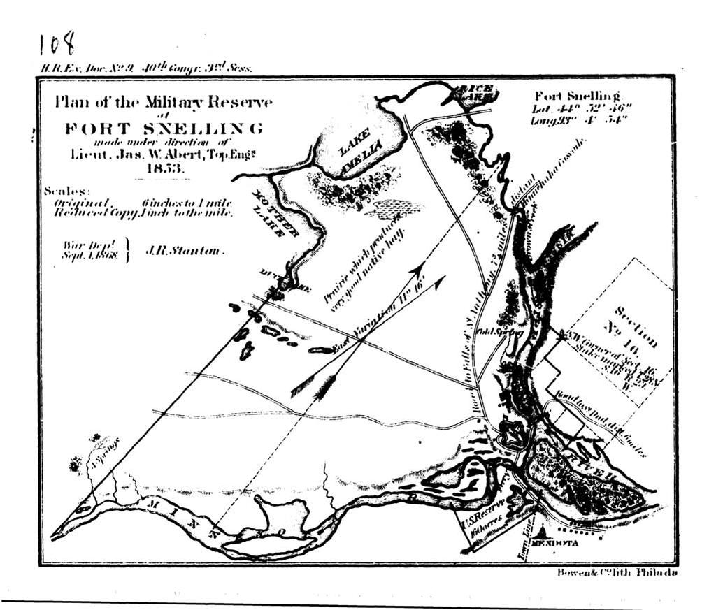
10 The Earliest Map
11 No mention of Pike s treaty in treaty of

12 The Basic Map May 6, 1839 firewood grazing non-military personnel
13 Township Exteriors East of the Mississippi Henry A. Wiltse 1847 James M. Marsh 1847
14 Townships Subdivided by Isaac N. Higbee East of the Mississippi
15 General Instructions issued by the Surveyor General Wisconsin and Iowa, George W. Jones, May 28,1846 All east of the Mississippi River Area ceded in treaty of 1837 no mention of the 1805 treaty All using the 4 th Principal Meridian Surveys at the end of 1851

16 Special Instructions issued by Surveyor General George W Jones Henry A Wiltse contract May 28, 1847 Henry A Wiltse contract May 28, th Principal Meridian to Lake Superior 3 rd Correction from the PM to the Mississippi Connecting surveys around Mississippi St Croix St Peter s confluence with those further east in Wisconsin Territory
17 Special Instructions to Marsh On May 27, 1847 George W Jones, the Surveyor General awarded James M. Marsh a contract to establish townships in western Wisconsin His special instructions contained no mention of the military reserve Herewith you are furnished a description of each of the existing township corners upon the south boundary of your district, with an accurate statement of the closing and magnetic variations of each several boundary thereof
18 Special Instructions issued by the Surveyor General to James M. Marsh contract dated May 28, 1847
19 On September 3, 1847 Surveyor General Jones awarded Isaac Higbee a contract to subdivide the townships adjoining the Mississippi that included a portion of the military reserve lying east of the River Again, there was no mention of the reservation in his special instructions
20

21 Higbee Subdivisions He ran random and correct section lines on east, north, and south tiers of sections
22 Special Instructions issued by the Surveyor General to Isaac Higbee contract September 3, 1847 Several township of the district of subdivisions assigned to you under contract of this date, are rendered fractional by the Mississippi river. In subdividing these townships, you are to regard the main channel of the said river as the boundary of your district upon the South and West, consequently you are to meander all islands in the said river within the said district, which are valuable either for their soil or timber You are to measure the left bank of so much of the Mississippi river as adjoins the district aforesaid. In executing this portion of your work you will please, as often as once in each of the said fractional townships ascertain by triangulation or otherwise the width of the said river and enter the same in its proper place in your meander notes
23 Higbee Special Instructions In your survey of the fractional townships above named should any one or more of your East & West lines, in closing upon the Mississippi river, exceed the just length of the tier or series of which such line is a portion, you, are, from the point of the full measure of such line or lines to run as directed under the head of township lines in the foregoing printed instructions due North & South respectively, until you intersect the said river in each direction. This line you are to establish at the proper Range line and you are to return the field notes thereof in a separate book, attested by yourself and assistants in the usual manner

24 March 15, 1848

25 March

26 March


27 Origin of this portion of the Original Military Reservation Line? Feb. 15, 1848
28 Plat certified by Surveyor General George Jones February 15, 1848 On May 6, 1848 the Commissioner of the General Land Office, Richard M. Young, wrote to Jones, I call your attention to the instructions from this Office of 29 July 1839 directing a reservation for Military purposes at Fort Snelling on the upper Mississippi; and to request that you will forward to this and the Register s office a diagram showing the connection of the Reservation with the lines of the public land surveys
29 May 19, 1848, the Surveyor General responded, writing, In compliance with part of your communication of the 6 th Inst., requiring me to indicate the connections of the public surveys with the Military reservation at Fort Snelling, I beg leave to transmit, for your examination, the enclosed diagram. The sketch of the said Reservation accompanying instructions from your office, dated 29 th July, 1839, was not the result of a survey, and gives neither course nor distance (?Map of May 6, 1839) Therefore.I have ventured to propose a boundary made to conform to regular subdivisional lines. The boundary follows very nearly upon the track of the one originally proposed, and comprises, as nearly as can be ascertained, an equal amount of land. Its upper point of intersection with the Mississippi river is precisely the same, and its lower point of intersection with the river, the same within five chains
30 On June 30 the Commissioner responded to his actions, stating, Yours of the 19 th inst. has also been received enclosing a diagram of that portion of the Military Reservation at Fort Snelling which is situated in Wisconsin. In the absence of marks or monuments in the field, showing the boundaries of this Reservation, the course pursued by you in tracing it along the boundaries of legal subdivisions was perfectly proper. You will please forward a copy of the diagram to the Register Here we have another instance when the plat was altered after being certified Question does the plat sent to Washington contain the military reservation?


31 Minnesota BLM

32
33 August An Act to reduce and define the Boundaries of the Military Reserve at the Saint Peter s River 10 Stat Directed the Secretary of War to cause the lines of the present military reserve at Fort Snelling, in the Territory of Minnesota, to be so contracted as to embrace the following boundaries. - restricted the reservation to land west of Mississippi The legislation authorized the Commissioner of the General Land Office to survey so much of the land heretofore included in the military reservation aforesaid, but without the limits of the military reserve aforesaid, as defined by this act as have not already been surveyed, and the land sold
34 Two parcels of land outside the reservation boundaries, were reserved for military purposes; a quarter section on the right bank of the St. Peter s river, at the present ferry a quarter section on the left bank of the Mississippi river, at the present ferry across that river, already surveyed by Isaac Higbee Two weeks later, on September 3, 1852 the Commissioner of the General Land Office wrote to the Register at the Stillwater land district office requesting that the location of the ferry reservation be marked on a map


35 T28N R23W
36 Jesse T. Jarrett Contract To establish the Original Military Reservation Line west of the River Why? 2. To run township exteriors 3. To subdivided the townships


37 Source Unknown

38 Point of Beginning Found a Post Source Unknown
39 Township Exteriors/Subdivisions West of the Mississippi Jesse T Jarrett

40 West of the Mississippi Instructions of Surveyor General George B. Sargent directed to use the Oregon Manual 1853 Surveyor General Warner Lewis directed to use the Oregon Manual?Special Instructions for Jarrett
41 Jarrett Sequence of Exteriors 1851 Instructions July 5-22, 1853 Starts on the west bank of the Mississippi Intersects the OMR Line Problem of setting posts?

42 Jarrett - Sequence of Subdividing B C D A H E F G A July 22 B July 23-Aug. 3 C Aug D Aug E Aug F Sept. 1-6 G Sept H Sept
43 ? Subdividing T27N R22W Sept ?

44 T27N R22W Feb

45 Ferry Ferry Feb


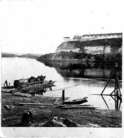
46 Townships & Subdivisions Jesse T. Jarrett May 30, 1853 Township lines James M. Marsh May 22,1847 Subdivision lines Isaac N. Higbee Sept 3,1847
47 Completed Maps


48


49


50
51 1853

52 1931 plat book showing Seth Eastman s 1857 division of the Reduced Military Reservation no field notes

53 Harper s Weekly 1861
54 The End
Rectangular Land Surveys in Territorial Minnesota
 Rectangular Land Surveys in Territorial Minnesota 1847-1858 My lineage as a Surveyor My lineage as a Surveyor My lineage as a Surveyor The rectangular public land survey net is one of the most visible
THE THREE MILE METHOD OF SURVEYING IN THE UTE MERIDIAN. Mesa County, Colorado
 THE THREE MILE METHOD OF SURVEYING IN THE UTE MERIDIAN Mesa County, Colorado Mesa County, located at the confluence of the Grand (Colorado) and Gunnison Rivers on the Western Slope, is a very unique area
U.S. Public Land Survey - Special Instructions A Case Study
 U.S. Public Land Survey - Special Instructions A Case Study by: John E. Freemyer, LS "One of the most important duties to be performed by the surveyor general is to provide the deputy surveyor with Special
The Public Land Survey Records for Minnesota It s a square world. Déjà vu - Again
 The Public Land Survey Records for Minnesota It s a square world Déjà vu - Again Presentations 2007 MSPS. The Past as Prolog: Public Land Survey Records for Minnesota Mn/DOT. A Partial Inventory of the
CFedS Outline Unit 1. Course 1: History, Records & Administrative Systems
 CFedS Outline Unit 1 Course 1: History, Records & Administrative Systems History of U.S. Surveying Historical Perspective Similarities in Surveying Seniority of Calls Lack of Standards A National Debt
Subdivision of Fractional Sections ISPLS 2017
 Subdivision of Fractional Sections ISPLS 2017 Dennis J. Mouland, PLS Instructor Witness Tree Consulting, Inc., 2011, All Rights Reserved Course Objectives Understand the definition of a fractional section
P.F. WOOD, APPELLANT, V. C. MANDRILLA, RESPONDENT. SAC. NO SUPREME COURT
 Supreme Court of California,Department Two. 167 Cal. 607 {Cal. 1914) WOOD V. MANDRILLA P.F. WOOD, APPELLANT, V. C. MANDRILLA, RESPONDENT. SAC. NO. 2089. SUPREME COURT OF CALIFORNIA,DEPARTMENT TWO. APRIL
SUBDIVISION APPLICATION
 SUBDIVISION APPLICATION City of Horn Lake Planning Department 3101 Goodman Road, W Horn Lake, MS 38637 662-342-3559 Fax: 662-342-3485 Applications due the 1st working day of the month. Submit application
INCOMPLETE APPLICATIONS WILL BE RETURNED! GENERAL PROPERTY INFORMATION. Applicant s name Day Phone address Authorized Agent (if applicable)
") Environmental Services Planning & Zoning 601 Third Avenue Two Harbors, MN 55616 www.co.lake.mn.us (218)834-8327 Fax: (218)-834-8365 LAKE COUNTY ADMINISTRATIVE SUBDIVISION APPLICATION PLEASE COMPLETE IN
Environmental Services Planning & Zoning 601 Third Avenue Two Harbors, MN 55616 www.co.lake.mn.us (218)834-8327 Fax: (218)-834-8365 LAKE COUNTY ADMINISTRATIVE SUBDIVISION APPLICATION PLEASE COMPLETE IN
Certified Federal Surveyor Program Assignment #3, Feedback
 Certified Federal Surveyor Program Assignment #3, Feedback Now that you have completed Assignment #3, take a few minutes to review the comments below. We have tried to identify items of special importance,
WYANDOT COUNTY BASIC STANDARDS FOR THE APPROVAL OF REAL ESTATE DEED TRANSFERS & LAND CONTRACT AGREEMENTS
 GENERAL In compliance with Section 315.251 of the Ohio Revised Code, the County Auditor and the County Engineer have adopted these written standards governing the conveyance of real property in Wyandot
Application for Preliminary Plat Checklist
 Application for Preliminary Plat Checklist Note: No portion of an existing parcel may be sold or transferred to another party without first legally subdividing the property according to the City of Richmond
Map Filing Law. 46: Effective date This act shall take effect January first, one thousand nine hundred and fiftyfour.
 46:23-9.8. Effective date This act shall take effect January first, one thousand nine hundred and fiftyfour. L.1953, c. 358, p. 1941, s. 8. 46:23-9.9. Short title This act shall be known and may be cited
Submittal Requirements: Subdivision Plat (Final)
") s Planning and Zoning Submittal Requirements: Subdivision Plat (Final) 1. Application form, APO fees, and filing fee. Transportation Development Review Fee please contact Engineering at (970) 221-6605
s Planning and Zoning Submittal Requirements: Subdivision Plat (Final) 1. Application form, APO fees, and filing fee. Transportation Development Review Fee please contact Engineering at (970) 221-6605
Survey and Recording Requirements
 Article C: Sec. 14-1-40 Survey and Recording Requirements Survey Requirements. (a) (b) (c) Prior to the final approval of land divisions to which this Chapter applies, the owner of the land shall have
BUREAU OF LAND MANAGEMENT. Fractional Sections. With John Farnsworth and Belle Craig C A D A S T R A L S U R V E Y
 BUREAU OF LAND MANAGEMENT Fractional Sections With John Farnsworth and Belle Craig 2009 C A D A S T R A L S U R V E Y Fractional Sections There are two types of fractional sections referenced in the 1973
Instructions for Maps to Accompany Proof of Appropriation and Beneficial Use of Ground Water
 Instructions for Maps to Accompany Proof of Appropriation and Beneficial Use of Ground Water Part II of the Proof of Appropriation (Form U.W. 8) All maps to accompany proof of appropriation and beneficial
INSTRUCTIONS FINAL PLAT APPROVAL APPLICATION
 INSTRUCTIONS FINAL PLAT APPROVAL APPLICATION 1. The applicant/agent shall fill out the attached application. The attached application form must be completely filled in before it can be filed. Portions
Preparing Property descriptions D A V I D T. BUTCHER, PLS
 Preparing Property descriptions D A V I D T. BUTCHER, PLS Who can prepare property descriptions? 327.272. Practice as professional land surveyor defined. 1. A professional land surveyor shall include any
The legal descriptions used in Georgia (the metes and bounds, and plat map also known as the lot and block system) appear in Chapter 27.
 appear in Chapter 27.") Chapter 28 Legal Descriptions in the Sales Transaction INTRODUCTION The legal descriptions used in Georgia (the metes and bounds, and plat map also known as the lot and block system) appear in Chapter
Chapter 28 Legal Descriptions in the Sales Transaction INTRODUCTION The legal descriptions used in Georgia (the metes and bounds, and plat map also known as the lot and block system) appear in Chapter
Center of Section. Computed or Monumented Position. Review and Commentary
 Center of Section Computed or Monumented Position Review and Commentary Center of Section Center of section defined by law for more than 200 years Computed position vs monumented position Examine the state
APPLICATION FOR MAJOR SUBDIVISION APPROVAL (FINAL PLAT)
") 209 S. Main Street Marysville, Ohio 43040 Phone: (937) 645-7350 Fax: (937) 645-7351 www.marysvilleohio.org APPLICATION FOR MAJOR SUBDIVISION APPROVAL (FINAL PLAT) *** IMPORTANT INFORMATION ~ Please read
209 S. Main Street Marysville, Ohio 43040 Phone: (937) 645-7350 Fax: (937) 645-7351 www.marysvilleohio.org APPLICATION FOR MAJOR SUBDIVISION APPROVAL (FINAL PLAT) *** IMPORTANT INFORMATION ~ Please read
TRANSFER PROCEDURES FOR WASHINGTON COUNTY, OHIO
 TRANSFER PROCEDURES FOR WASHINGTON COUNTY, OHIO The following requirements are adopted and established in conjunction with the Washington County Engineer and the Washington County Auditor as prescribed
STANDARDS GOVERNING CONVEYANCES OF REAL PROPERTY
 STANDARDS GOVERNING CONVEYANCES OF REAL PROPERTY Hancock County, Ohio Charity A. Rauschenberg, Hancock County Auditor Steven C. Wilson, Hancock County Engineer Revised: March 1, 2007 TRANSFER AND CONVEYANCE
8. CONSTRUCTION SCHEDULE
 8. CONSTRUCTION SCHEDULE The project's authorizing legislation (PL 106-382, October 27, 2000) provides that funds for construction are to be appropriated..."over a period of 10 fiscal years..." (114 stat
CERTIFIED SURVEY MAP
 SCONSIN STATE PLANE N:389676.12 E:2130390.15 Center of Section 23 CERTIFIED SURVEY MAP 734.06' THE (PRITCHETTE) ORIGINAL PLAT OF ALL IN THE NW 1 4 OF THE SE 1 4 OF FRACTIONAL SECTION 23, T7N, R9E, IN THE
STANDARDS GOVERNING CONVEYANCES OF REAL PROPERTY IN DARKE COUNTY, OHIO
 STANDARDS GOVERNING CONVEYANCES OF REAL PROPERTY IN DARKE COUNTY, OHIO As directed by Section 319.203 of the Ohio Revised Code which states The County Auditor and the County Engineer shall adopt standards
CHAPTER FINAL AND PARCEL MAPS
 CHAPTER 19.48 FINAL AND PARCEL MAPS Section Page 19.48.010 General... IV-25 19.48.020 Phasing... IV-25 19.48.030 Survey Required... IV-26 19.49.040 Form... IV-26 19.48.050 Contents... IV-27 19.48.060 Preliminary
RESTORATION OF LOST OR OBLITERATED CORNERS & SUBDIVISION OF SECTIONS a guide for surveyors
 DISCLAIMER The following is a retyped electronic version of "RESTORATION OF LOST OR OBLITERATED CORNERS AND SUBDIVISION SECTIONS", a supplement to the Manual of Surveying Instructions, designed to be word
THE COUNTY BOARD OF SUPERVISORS OF THE COUNTY OF DOUGLAS DOES ORDAIN AS FOLLOWS:
 8.1 SUBDIVISION CONTROL ORDINANCE THE COUNTY BOARD OF SUPERVISORS OF THE COUNTY OF DOUGLAS DOES ORDAIN AS FOLLOWS: SECTION I. GENERAL INTERPRETATION This ordinance shall not repeal, impair or modify private
REQUIREMENTS FOR ALL INSTRUMENTS OF CONVEYANCE IN HARDIN COUNTY, OHIO
 REQUIREMENTS FOR ALL INSTRUMENTS OF CONVEYANCE IN HARDIN COUNTY, OHIO Effective Date: Michael L. Smith, P.E., P.S. Hardin County Engineer Michael T. Bacon Hardin County Auditor 1 I. GENERAL In compliance
SUBDIVISION APPLICATION CHECKLIST SKETCH PLAN PRELIMINARY PLAT FINAL PLAT
 RECEIVED STAMP SUBDIVISION APPLICATION CHECKLIST SKETCH PLAN PRELIMINARY PLAT FINAL PLAT A checklist of background information and submission requirements for processing of a sketch plan, preliminary plat
PLANNING DIRECTOR. Approved by the Planning Director on this day of, A.D. 20. day of, A.D. 20. Approved by the Fire Chief on this
 Located in a portion of the West Half of Section 19, Township 5 South, Range 1 East, Salt Lake Base and Meridian. SURVEYOR'S CERTIFICATE I, the undersigned surveyor, do hereby certify that I am a registered
Methods of Legal Description Metes and Bounds The Rectangular Survey System Recorded Plat Method Describing Elevation
 9 Legal Descriptions Methods of Legal Description Metes and Bounds The Rectangular Survey System Recorded Plat Method Describing Elevation METHODS OF LEGAL DESCRIPTION There are many common ways of describing
ARTICLE SINGLE FAMILY SITE CONDOMINIUM DEVELOPMENT STANDARDS
 ARTICLE 28.00 SINGLE FAMILY SITE CONDOMINIUM DEVELOPMENT STANDARDS Section 28.01 PURPOSE The purpose of this Article is to recognize that conventional single family developments, traditionally developed
CHAPTER 8 - LAND DESCRIPTIONS
 CHAPTER 8 - LAND DESCRIPTIONS Notes: While the location of land is commonly referred to by street number and city, it is necessary to use the legal description in the preparation of those instruments relating
Requirements for All Instruments of Conveyance in Logan County, Ohio
 Requirements for All Instruments of Conveyance in Logan County, Ohio Effective Date: April 11, 1997 It is the intent of these requirements to provide a standard method of checking legal descriptions for
APPLICATION FOR FINAL PLAT APPROVAL
 APPLICATION FOR FINAL PLAT APPROVAL Section 1. General. The undersigned Applicant (Applicant is synonymous with owner) makes this Application for Final Plat Approval in accordance with Chapter 21, Port
Department of Development Services Engineering; Survey Plat Review Group SPRG
 Department of Development Services Engineering; Survey Plat Review Group SPRG CITY OF DALLAS LEGAL DESCRIPTION PREPARATION GUIDELINE AND CHECKLIST The following guideline and checklist are provided to
SYSTEMS OF PROPERTY DESCRIPTION
 SYSTEMS OF PROPERTY DESCRIPTION Interpretation of Common Real Property Descriptions INTRODUCTION Land surveying includes 1. Surveying operations involved in original surveys to locate and monument the
The Sale or Lease of Certain Lands Act
 1 SALE OR LEASE OF CERTAIN LANDS S-2 The Sale or Lease of Certain Lands Act being Chapter S-2 of The Revised Statutes of Saskatchewan, 1978 (effective February 26, 1979) as amended by the Statutes of Saskatchewan,
SECTION 2. PROCEDURES FOR FILING AND REVIEW
 SECTION 2. PROCEDURES FOR FILING AND REVIEW Subdivision 2.01 Sketch Plan 2.02 Preliminary Plat 2.03 Final Plat 2.04 Certification Required 2.05 Denial of Plat 2.06 Administrative Subdivision 2.01 SKETCH
BRIDGETON SUBDIVISION APPLICATION CHECKLIST
 APPLICATION NAME AND # CHECKLIST COMPLETED BY: DATE: Signature and printed name BRIDGETON SUBDIVISION APPLICATION CHECKLIST TO SUBDIVISION APPLICANTS: The attached checklist is to assist you in the submission
SUBMITTAL REQUIREMENTS
 PRELIMINARY PLAT APPLICATION ***A PRE-APPLICATION MEETING WITH CITY STAFF IS REQUIRED FOR THIS APPLICATION*** DATE STAMP FOR CITY USE ONLY PROJECT NAME (if any): TO BE FILLED OUT BY APPLICANT PROJECT STREET
TOWNSHIP OF LANARK HIGHLANDS POLICY FOR THE STOPPING UP, CLOSURE AND SALE OF ROADS POLICY STATEMENT
 TOWNSHIP OF LANARK HIGHLANDS POLICY FOR THE STOPPING UP, CLOSURE AND SALE OF ROADS Approval Date: POLICY STATEMENT The Municipal Act provides that the Council of a municipality may pass by-laws for stopping
WATERFORD LANDING COMMUNITY DEVELOPMENT DISTRICT REGULAR MEETING AGENDA
 WATERFORD LANDING COMMUNITY DEVELOPMENT DISTRICT REGULAR MEETING AGENDA January 31, 2019 Waterford Landing Community Development District OFFICE OF THE DISTRICT MANAGER 2300 Glades Road, Suite 410W Boca
Enforcement of Minimum Survey Standards
 Presented By: F. Anthony Rettke, P.S., Tax Map Supervisor, Franklin County John Greenhalge, Executive Director, State Board of Registration n the Ohio Revised Code, Section 315.251: If a deed conveying
Certified Federal Surveyor Program Standards of Practice Handbook (Modified February 19, 2013 and November 18, 2014) "Trained to Make a Difference"
 Trained to Make a Difference") Certified Federal Surveyor Program Standards of Practice Handbook (Modified February 19, 2013 and November 18, 2014) "Trained to Make a Difference" Introduction This handbook is designed to document the
Certified Federal Surveyor Program Standards of Practice Handbook (Modified February 19, 2013 and November 18, 2014) "Trained to Make a Difference" Introduction This handbook is designed to document the
Standards for All Instruments of Conveyance
 Standards for All Instruments of Conveyance Perry County, Ohio Effective Date: May 1, 1997 Effective Date of Revision: April 1, 2011 Page 2 of 12 Minimum Standards for all Instruments of Conveyance Perry
City Council Information Form
 City Council Information Form DATE: 08/13/2014 ASSIGNED STAFF: Robert McKay DEPARTMENT: Planning&Development TYPE OF FORM: Ordinances Form No.: 4490 APPROVALS: None ISSUE/REQUEST: AN ORDINANCE VACATING
NOTICE OF AVAILABILITY
 NOTICE OF AVAILABILITY NOTICE NO. DACW25-9-17-4049 FOR LEASING DEPARTMENT OF THE ARMY REAL PROPERTY IN ROCK ISLAND COUNTY, ILLINOIS, FOR AGRICULTURAL PURPOSES MISSISSIPPI RIVER NINE-FOOT CHANNEL PROJECT
Road Easement Vacation Instructions
 Road Easement Vacation Instructions A road easement vacation removes a public right of way easement from the property of the adjoining owners. It is the County's duty to ensure that vacating a public easement
SUBDIVISION APPLICATION
 SUBDIVISION APPLICATION Preliminary Plat Minor Plat Final Plat Amended Plat Applicant Name: Owner (if different from applicant) Name: Company: Company: Address: Address: City, State, Zip City, State, Zip
SUBDIVISION APPLICATION
 SUBDIVISION APPLICATION Community Planning and Economic Development Development Services Division 250 South 4 th Street, Room 300 Minneapolis MN 55415-1316 612-673-3000 This application packet is used
CHICAGO TITLE INSURANCE COMPANY a corporation, herein called the Company GUARANTEES. Western Surveying
 SUBDIVISION Issued By: Guarantee/Certificate Number: Western CHICAGO TITLE INSURANCE COMPANY a corporation, herein called the Company GUARANTEES Western Surveying herein called the Assured, against actual
Printable Lesson Materials
 Printable Lesson Materials Print these materials as a study guide These printable materials allow you to study away from your computer, which many students find beneficial. These materials consist of two
OTTAWA COUNTY LEGAL DESCRIPTION REVIEW GUIDELINES
 OTTAWA COUNTY LEGAL DESCRIPTION REVIEW GUIDELINES APPROVED BY: RONALD P. LAJTI, JR., P.E., P.S. OTTAWA COUNTY ENGINEER APPROVED BY: LAWRENCE HARTLAUB OTTAWA COUNTY AUDITOR EFFECTIVE DATE: January 1, 2017
ORDINANCE 2014-_. WHEREAS, Santa Rosa Island of Escambia County is unique in both usage and geography; and,
 ORDINANCE 2014-_ AN ORDINANCE RELATING TO ESCAMBIA COUNTY, FLORIDA; AMENDING CHAPTER 42, ARTICLE III, SECTIONS 42-63 AND 42-67 OF THE CODE OF ORDINANCES; DEFINING THE CORE AREA OF SANTA ROSA ISLAND; MODIFYING
SUBDIVISION APPLICATION INSTRUCTIONS
 SUBDIVISION APPLICATION INSTRUCTIONS APPLICATION FORM The application form must be fully completed, signed by the property owner and shall be properly notarized. AGENT AUTHORIZATION FORM If the applicant
Ordinance DRAFT An ordinance amending Clallam County Code, Chapter 29.20, Final Plan Requirements and Process, to (fill-in)
") Ordinance DRAFT 07-03 An ordinance amending Clallam County Code, Chapter 29.20, Final Plan Requirements and Process, to (fill-in) BE IT ORDAINED BY THE BOARD OF CLALLAM COUNTY COMMISSIONERS: Section 1.
Ordinance DRAFT 07-03 An ordinance amending Clallam County Code, Chapter 29.20, Final Plan Requirements and Process, to (fill-in) BE IT ORDAINED BY THE BOARD OF CLALLAM COUNTY COMMISSIONERS: Section 1.
JOINT RESOLUTION AMENDING JOINT RESOLUTION AS TO ORDERLY ANNEXATION: THE TOWN OF STILLWATER AND CITY OF STILLWATER
 JOINT RESOLUTION AMENDING JOINT RESOLUTION AS TO ORDERLY ANNEXATION: THE TOWN OF STILLWATER AND CITY OF STILLWATER WHEREAS, the Town of Stillwater and the City of Stillwater, Washington County, Minnesota,
Easements, Establishments, Abandonments and Vacations
 Easements, Establishments, Abandonments and Vacations Highway Easements: Where there is a right to construct and maintain a highway facility SH - Standard Highway easement LA - Limited Access Easement
CHAPTER 4 FINAL PLAT
 10-4-1 10-4-2 CHAPTER 4 FINAL PLAT SECTION: 10-4-1: Tentative Final Plat 10-4-2: Filing 10-4-3: Requirements 10-4-4: Amended Plats 10-4-5: Approval 10-4-6: Subdivision Agreement 10-4-1: TENTATIVE FINAL
APPLICATION FOR PRELIMINARY PLAT CERRO GORDO COUNTY, IOWA
 APPLICATION FOR PRELIMINARY PLAT CERRO GORDO COUNTY, IOWA Before subdividing any tract of land and previous to the filing of an Application for conditional approval of the Preliminary Plat, the subdivider
Requirements For All Instruments of Conveyance In Monroe County, Ohio. Transfer and Conveyance Standards of the Monroe County Auditor & Engineer
 Requirements For All Instruments of Conveyance In Monroe County, Ohio Transfer and Conveyance Standards of the Monroe County Auditor & Engineer Effective November 8, 2013 1 TRANSFER PROCEDURES FOR MONROE
APPENDIX A DETAILED DESCRIPTION OF THE LANDS SEPARATED FROM LEDUC COUNTY AND ANNEXED TO THE TOWN OF BEAUMONT
 APPENDIX A DETAILED DESCRIPTION OF THE LANDS SEPARATED FROM LEDUC COUNTY AND ANNEXED TO THE TOWN OF BEAUMONT ALL THAT PORTION OF SECTION ONE (1), TOWNSHIP FIFTY-ONE (51), RANGE TWENTY- FOUR (24) WEST OF
STONE COUNTY PRELIMINARY PLAT CHECKLIST. Note: Applications need to be in the office by 2 p.m. on the cutoff day.
 STONE COUNTY PRELIMINARY PLAT CHECKLIST Note: Applications need to be in the office by 2 p.m. on the cutoff day. JOY WILSON, DIRECTOR Return form to: Planning & Zoning Administrator PO Box 301, Galena,
SECTION 10 STANDARD PLATS
 SECTION 10 - STANDARD PLATS Subdivision 1: Purpose Standard Plats allow the subdivision of land into lots smaller than the minimum metes and bounds size in the zoning district, and control road development
GENESEE VALLEY LAND SURVEYORS ASSOCIATION MINIMUM STANDARDS FOR A MAP OF A SURVEY. Effective Date: February 15, 2017
 GENESEE VALLEY LAND SURVEYORS ASSOCIATION MINIMUM STANDARDS FOR A MAP OF A SURVEY Effective Date: February 15, 2017 1. The Land Surveyor shall perform due diligence in their research, maintain proper documentation
Rule 21 STANDARDS OF PRACTICE FOR SURVEYING
 Rule 21 STANDARDS OF PRACTICE FOR SURVEYING 21.1 Whenever a survey is performed, it shall comply with Section 73-13-71 (4) and Section 73-13- 73 and the Standards of Practice for Surveying in Mississippi
HISTORICAL CREATION OF INDIANA ROADS (How To Determine Existing Right of Way) January 19, 2017 Jason McCort, P.S.
 January 19, 2017 Jason McCort, P.S.") HISTORICAL CREATION OF INDIANA ROADS (How To Determine Existing Right of Way) January 19, 2017 Jason McCort, P.S. DEFINITION OF RIGHT OF WAY The right of passage held by the public in general to travel
HISTORICAL CREATION OF INDIANA ROADS (How To Determine Existing Right of Way) January 19, 2017 Jason McCort, P.S. DEFINITION OF RIGHT OF WAY The right of passage held by the public in general to travel
HENRY COUNTY CONVEYANCE STANDARDS AND LAND TRANSFER POLICY
 HENRY COUNTY CONVEYANCE STANDARDS AND LAND TRANSFER POLICY REVISED DECEMBER 2013 Approved By: Kevin Garringer - County Auditor Timothy J. Schumm, P.E., P.S. - County Engineer Land Transfer Policy Committee:
CR_2017 Page 1 of 5. Corner Records
 CR_2017 Page 1 of 5 Corner Records Corner Record Check List Santa Barbara County Surveyor s Office (Examination in accordance with the PLS Act and Board Rule 464) Document No.: CR Agency Index: APN Review
An Act to Incorporate The Lutheran College and Seminary
 LUTHERAN COLLEGE AND SEMINARY, INCORPORATING c. 60 1 An Act to Incorporate The Lutheran College and Seminary being a Private Act Chapter 60 of the Statutes of Saskatchewan, 1924 (effective March 25, 1924)
BOUNDARY LINE ADJUSTMENT PROCEDURE
 Assessor s Department 108 8 th Street, Suite 207 Glenwood Springs, CO 81601 (970) 945-9134 www.garfield-county.com BOUNDARY LINE ADJUSTMENT PROCEDURE Pursuant to C.R.S. 38-44-112, any uncertain boundary
To provide for the review of the final engineering plans, the subdivision improvement agreement, public dedications, and other legal agreements.
 ARTICLE 5 FINAL PLAT 501 Intent DOUGLAS COUNTY SUBDIVISION RESOLUTION To provide for the review of the final engineering plans, the subdivision improvement agreement, public dedications, and other legal
Applicant: Address: Fee Owner: Address: Property Location (Address and Complete (long) Legal Description: Detailed Reason for Request:
 Legal Description: Detailed Reason for Request:") Date Received: Received By: Permit #: LAND USE APPLICATION Comprehensive Plan Zoning District Amend Zoning Text Amend Variance*(see below) Zoning Appeal Conditional Use Permit (C.U.P.) Flood Plain C.U.P.
Date Received: Received By: Permit #: LAND USE APPLICATION Comprehensive Plan Zoning District Amend Zoning Text Amend Variance*(see below) Zoning Appeal Conditional Use Permit (C.U.P.) Flood Plain C.U.P.
Certified Federal Surveyor Program Assignment #6, Feedback
 Certified Federal Surveyor Program Assignment #6, Feedback Now that you have completed Assignment #6, take a few minutes to review the comments below. We have tried to identify items of special importance,
SHORT PLAT APPLICATION CHECKLIST City of White Salmon. Application completed with notarized signatures
 SHORT PLAT APPLICATION CHECKLIST City of White Salmon Application completed with notarized signatures Road Classification as assigned by City Public Works Director City Public Works Director Certification
BOUNDARY SURVEYS RE-SURVEYS
 BOUNDARY SURVEYS RE-SURVEYS One of the difficult tasks for a surveyor is the re-surveying of lands, the re-location of the boundary lines between privately-owned lands or the re-location of the boundary
Community Development Department Council Chambers, 7:30 PM, December 1, 2016
 STAFF REPORT 2016-35P: Subdivision Community Development Department Council Chambers, 7:30 PM, December 1, 2016 To: From: Re: Paul Luke, Chairman, Skokie Plan Commission Mike Voitik, Planning Technician
BILL NO (Emergency Measure) ORDINANCE NO. 5072
 ORDINANCE NO. 5072") BILL NO. 5210 (Emergency Measure) ORDINANCE NO. 5072 AN ORDINANCE AUTHORIZING THE MAYOR TO EXECUTE WITH MICHELSON-HADLEY HEIGHTS DEVELOPMENT, LLC, A CONTRACT AND QUIT CLAIM DEED CONVEYING CERTAIN PROPERTIES
BILL NO. 5210 (Emergency Measure) ORDINANCE NO. 5072 AN ORDINANCE AUTHORIZING THE MAYOR TO EXECUTE WITH MICHELSON-HADLEY HEIGHTS DEVELOPMENT, LLC, A CONTRACT AND QUIT CLAIM DEED CONVEYING CERTAIN PROPERTIES
RESOLUTION TO ACCEPT DEED OF DEDICATION FOR A RELOCATED UTILITY EASEMENT AS SHOWN ON APPROVED SUBDIVISION PLAN FOR THE LOWER MERION HIGH SCHOOL
 Exhibit D RESOLUTION TO ACCEPT DEED OF DEDICATION FOR A RELOCATED UTILITY EASEMENT AS SHOWN ON APPROVED SUBDIVISION PLAN FOR THE LOWER MERION HIGH SCHOOL WHEREAS, the Board of Commissioners of the Township
WHEN DANIEL BOONE led pioneers across the
 Understanding Land Measurement and Legal Descriptions WHEN DANIEL BOONE led pioneers across the Appalachian Mountains in the 1700s, it was an accepted practice for them to establish property boundaries
FINAL PLAT GUIDE TO SUBDIVIDING PROPERTY. Background
 FINAL PLAT GUIDE TO SUBDIVIDING PROPERTY Background A final plat is the second step in the process of subdividing land into separate parcels for future sale or lease. Once a preliminary plat has been approved
City Council Information Form
 City Council Information Form DATE: 06/12/2015 ASSIGNED STAFF: Christina Stanton DEPARTMENT: Planning&Development TYPE OF FORM: Ordinances Form No.: 4898 APPROVALS: None ISSUE/REQUEST: AN ORDINANCE ACCEPTING
TOWN OF LERAY PLANNING BOARD Minor Subdivision Application Packet
 This Packet is designed to assist applicants in providing the forms needed for submission of a 1 to 4 lot subdivision to the Planning Board for approval. The following should be filled out to ensure the
CHAPTER 5. Subdivisions Regulations
 CHAPTER 5 Subdivisions Regulations 10-5-1 Introduction and Purpose 10-5-2 Definitions 10-5-3 General Provisions 10-5-4 Procedure for Submitting Subdivisions 10-5-5 Design Standards; Streets and Lots 10-5-6
(Continued on back of page)
") Definitions Certificate of Survey is the subdivision of land into three or fewer tracts of land. The remnant tract counts as one tract. Plat is the subdivision of land into more than three tracts of land.
Definitions Certificate of Survey is the subdivision of land into three or fewer tracts of land. The remnant tract counts as one tract. Plat is the subdivision of land into more than three tracts of land.
1. NAME OF SUBDIVISION : DATE SUBMITTED: LOCATION OF SUBDIVISION : DATE OF PRELIMINARY APPROVAL BY TOWNSHIP SUPERVISORS:
 1 RICHLAND TOWNSHIP PLANNING COMMISSION 322 SCHOOLHOUSE ROAD, SUITE 110 JOHNSTOWN, PA 15904 FINAL SUBDIVISION APPLICATION LAND DEVELOPMENT OR LAND MERGER OR MINOR SUBDIVISION THE UNDERSIGNED HEREBY APPLIES
WESTON COUNTY FINAL PLAT APPLICATION
 WESTON COUNTY FINAL PLAT APPLICATION Property Owner: Mailing Address of owner: Telephone Number(s) of owner: Property Owner: Mailing Address of owner: Telephone Number(s) of owner: (If subdivider/applicant
RULES OF THE GEORGIA STATE BOARD OF REGISTRATION FOR PROFESSIONAL ENGINEERS AND LAND SURVEYORS CHAPTER APPLICATIONS TABLE OF CONTENTS
 RULES OF THE GEORGIA STATE BOARD OF REGISTRATION FOR PROFESSIONAL ENGINEERS AND LAND SURVEYORS CHAPTER 180-7 APPLICATIONS TABLE OF CONTENTS 180-7-.07 Maps and Plats. All maps, plats and similar documents
THE CORPORATION OF THE MUNICIPALITY OF HIGHLANDS EAST BY-LAW
 THE CORPORATION OF THE MUNICIPALITY OF HIGHLANDS EAST BY-LAW 2007-53 BEING A BY-LAW TO ESTABLISH A TOWNSHIP POLICY ON THE USE OF UNOPENED ROAD ALLOWANCES WHEREAS, Section 44 of the Municipal Act, 2001,
Sale # Conveyance TO BE SOLD BY SEALED BID April 23, County Road B2 Roseville, MN 55113
 Sale 139474: SW Quad Snelling & I-94, St Paul, Ramsey County, MN Containing approximately 20,927 square feet Minimum Bid Accepted: $1,150,000.00 INTERESTED BIDDERS Inspect the property and inform yourselves
APPLICATION FOR MAJOR SUBDIVISION APPROVAL (PRELIMINARY PLAT)
") 209 S. Main Street Marysville, Ohio 43040 Phone: (937) 645-7350 Fax: (937) 645-7351 www.marysvilleohio.org APPLICATION FOR MAJOR SUBDIVISION APPROVAL (PRELIMINARY PLAT) *** IMPORTANT INFORMATION ~ Please
209 S. Main Street Marysville, Ohio 43040 Phone: (937) 645-7350 Fax: (937) 645-7351 www.marysvilleohio.org APPLICATION FOR MAJOR SUBDIVISION APPROVAL (PRELIMINARY PLAT) *** IMPORTANT INFORMATION ~ Please
SECTION 3.1 Zoning Permit Required for Construction, Land Use and Development.
 CHAPTER 3 ADMINISTRATION, FEES AND ENFORCEMENT SECTION 3.1 Zoning Permit Required for Construction, Land Use and Development. A. Zoning Permit Required. A zoning permit is required for any of the following
NORTH CAROLINA PROPERTY MAPPERS ASSOCIATION SECTION 6 PUBLIC LANDS
 NORTH CAROLINA PROPERTY MAPPERS ASSOCIATION SECTION 6 PUBLIC LANDS 6-1 6.1 Introduction Following our independence from England, the Congress in 1783 of the newly formed United States of America was faced
Circuit Court, D. Nebraska. March 1, 1889.
 EAST OMAHA LAND CO. V. JEFFRIES. Circuit Court, D. Nebraska. March 1, 1889. 1. BOUNDARIES ACCRETIONS CONVEYANCE. Rev. St. U. S. 2396, provides that the boundaries and contents of the several sections,
ORDINANCE NO.: Adopted: August 2, 2005 Amended: March 27, 2007 Amended: September 23, Fillmore County Rural Addressing Ordinance
 ORDINANCE NO.: 2005-01 Adopted: August 2, 2005 Amended: March 27, 2007 Amended: September 23, 2008 Fillmore County Rural Addressing Ordinance Section 1 Purpose, Scope and Statutory Authorization 1-1 Purpose.
STANDARDS GOVERNING CONVEYANCES OF REAL PROPERTY IN SENECA COUNTY OHIO
 STANDARDS GOVERNING CONVEYANCES OF REAL PROPERTY IN SENECA COUNTY OHIO EFFECTIVE July 8, 1996 Seneca County Auditor FIRST HEARING June 14, 1996 SECOND HEARING June 26, 1996 Seneca County Engineer TABLE