Request for Proposal RFP
|
|
|
- Jeffry Day
- 5 years ago
- Views:
Transcription
, Mental Health Trust Land Office (TLO), is soliciting proposals for professional land surveyor services in the Juneau, Sitka, and Wrangell areas as specified within this RFP.")
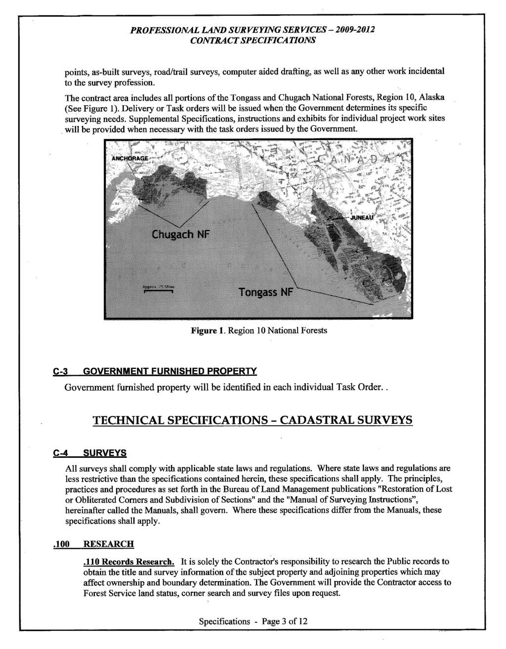
1 STATE OF ALASKA Department of Natural Resources Request for Proposal RFP TITLE: Land Survey for Juneau, Sitka, & Wrangell Areas for TLO PURPOSE: The Department of Natural Resources (DNR), Mental Health Trust Land Office (TLO), is soliciting proposals for professional land surveyor services in the Juneau, Sitka, and Wrangell areas as specified within this RFP. Important Notice: If you receive this solicitation from the State's Online Public Notice website or IRIS Vendor Self Service portal, you must register with the DNR Procurement Section to receive subsequent amendments. Registration must be in writing and may be made via to or fax to Failure to register with the DNR Procurement Section may result in rejection of your offer. ADA: The State of Alaska complies with Title II of the Americans with Disabilities Act of Individuals with disabilities who may need auxiliary aids, services, and/or special modifications to submit a bid should contact the DNR Procurement Section via to dnr.ssd.procurement@alaska.gov, fax to , telephone at or , or TDD at not later than 10 calendar days prior to the bid closing date to make necessary arrangements. Rev. 12/14 Page 1 of 3
2 Date of Issue: January 08, 2018 Deadline for Receipt of Proposals: January 31, :00:00 Important Notice: If you received this solicitation from the State of Alaska's "Vendor Self-Service" web site, you must register with the procurement officer to receive subsequent amendments. Failure to contact the procurement officer may result in the rejection of your offer. PROCUREMENT OFFICER: James Sonnier TELEPHONE NUMBER: (907) BID RECEIVING LOCATION: Support Services ANC Admin Attn: Procurement 550 West 7th Avenue Anchorage, AK Rev. 12/14 Page 2 of 3
3 Does your business qualify for the Alaska bidder preference? PREFERENCES Does your business qualify for the Alaska veteran preference? Yes No Yes No PROPOSAL SCHEDULE Event Date 01/18/18 Questions Due Event Description 01/31/18 Solicitation Closing Date/Time LINE ITEMS Line No. Description Quantity Unit Unit Cost 1 Land Survey for Juneau, Sitka, & Wrangell Areas for TLO Start Date End Date Delivery Date F.O.B. Point Extended Line Total 02/27/18 05/31/19 Extended Description: Professional land surveyor services in the Juneau, Sitka, and Wrangell areas as specified within this RFP. DO NOT ENTER COST IN THIS AREA. EVALUATION CRITERIA The following criteria will be used when determining the award of this solicitation Code Criteria Description Points Vendor Response (DO NOT LIST PRICES IN THIS SECTION. UNIT PRICES AND TOTAL PRICES MUST BE FILLED IN ADJACENT TO THEIR LINE ITEMS.) 2 Experience 40 3 Methodology 20 4 Management Plan 20 5 Understanding 10 7 AK Offeror Pref 10 No. 004 Request for Proposals Terms and Conditions Name Section Rev. 12/14 Page 3 of 3
4
5
6
7
8
9
10
11
12
13
14
15
16
17
18
19
20
21
22
23
24
25
26
27
28
29
30
31
32
33
34
35
36
37
38
39
40
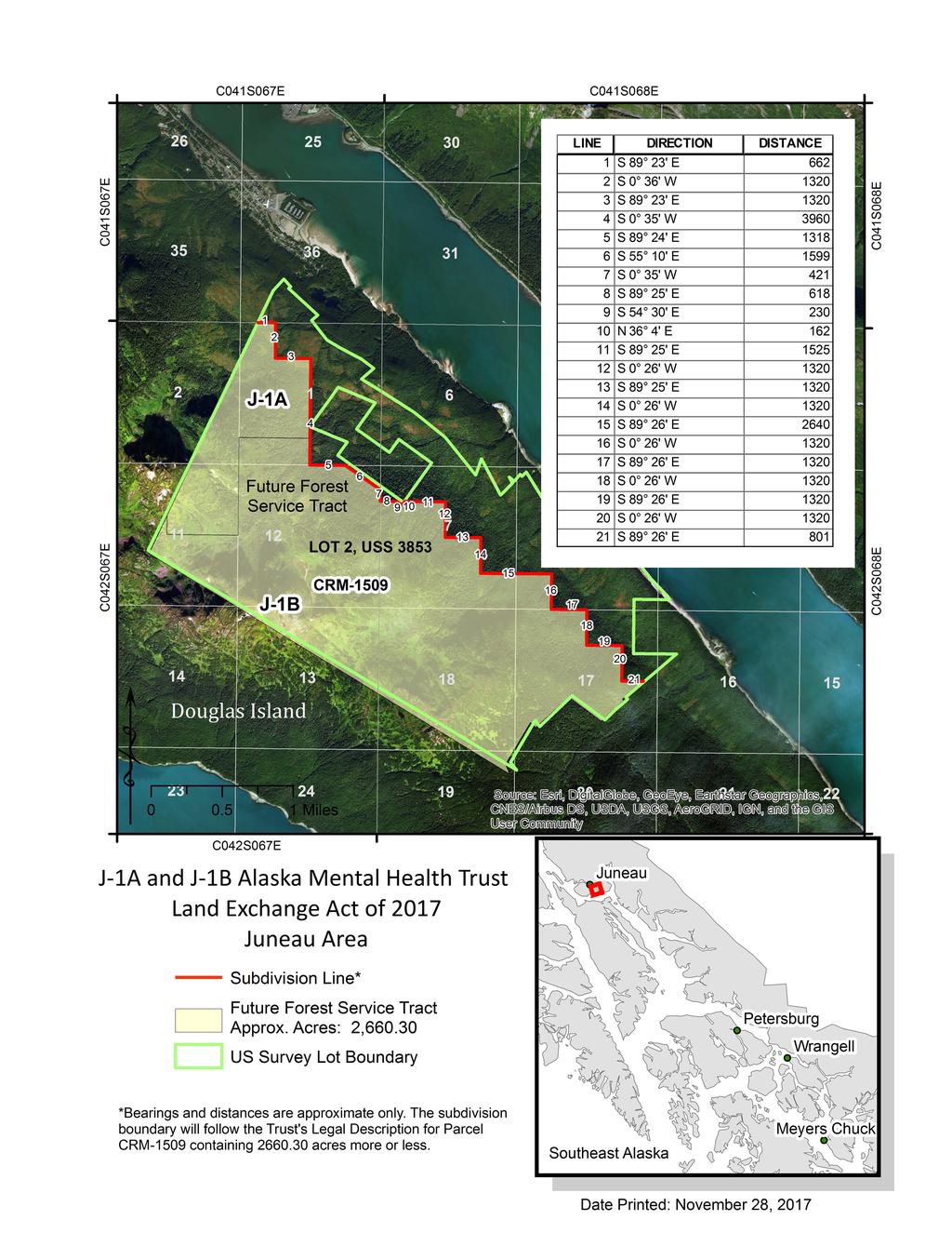
41 JUNEAU J-1A-J-1B PARCEL DESCRIPTION OF WORK All work must be performed under the direct supervision of a land surveyor licensed to practice in the State of Alaska. All work must meet the Juneau Borough Subdivision standards, specifications, and process. Except for the furnished property below, The Contractor shall furnish all labor, supervision, transportation, equipment, supplies, materials and incidentals necessary to complete the work as specified. This contract is to provide professional surveying services to: OPTION 1 1. Subdivide Lot 2 of U.S. Survey No. 3853, Alaska to create a tract of land, "Tract A" approximately 2660 acres, as described by the Trust legal description CRM 1509,attached hereon. Tract A, will be deeded to the Forest Service. 2. Draft a preliminiary Subdivision Plat showing the proposed boundaries of the Tracts for review by the Trust and Forest Service. 3. Draft and process a subdivision plat to the standards and specifications of the Juneau Borough. OPTION 2 1. Clear, mark, post & paint the future Forest Service boundary of Tract A adjoining non Federal lands to the U.S. Forest Service Standards as outlined in the Forest Service Region 10, Alaska Region, Tongass and Chugach National Forest Professional Land Survey Services CY Contract Specification. No brush or trees shall be cut on adjoining non-trust Land without written permission from the owner. FURNISHED PROPERTY (1) Corner monuments, signs, and sign posts will be provided as necessary by the Forest Service. RECORD RESEARCH AND ADJOINER NOTIFICATION (1) Record Research. It is the Contractor's responsibility to research all pertinent private and public records to obtain the title and survey history of the subject property and adjoining properties.
42 (2) Adjoiner Notification Prior to the start of fieldwork. The contractor shall contact all adjoining landowner to secure permission to access their lands, and to clear and mark their side of the boundary line. Contact of adjoiners shall be by letter with a self-addressed envelope. A sample Letter is attached. ADDITIONAL SURVEY SPECIFICATIONS In addition to the Borough Subdivision specification the Contractor shall comply with the U.S. Forest Service Standards as outlined in the Forest Service Region 10, Alaska Region, Tongass and Chugach National Forest Professional Land Survey Services CY Contract Specification document attached relating to the following: 1. Trespass Conflicts. If trespass conflicts are found the Contractor shall as soon as posible provide the location, information and photos to the Trust Office. 2. Corner Monuments and Accessories. The contractor shall replace missing or existing monuments in poor condition with the furnished monument posts. If missing, dead or dying Bearing Trees are found the contractor shall establish new ones. 3. Survey Control. Horizontal Control shall be based on the NAD 83 Datum, US Survey feet. An NGS OPUS GPS solution would be acceptable for the basis of horizontal control. The contractor shall determine the Latitude and Longitude (NAD 83) for an original recovered corner monument. 4. Subdivision Plat. The Contractor shall produce a subdivision plat compling with all Borough subdivision standards. The plat shall be based on True North, NAD 83. One paper copy of the plat shall be submitted to the Trust Land Office for review at all stages of the platting process 5. Boundary Line Location, Clearing, Marking, Posting, Painting, and permission to perform work on private land. QUALITY CONTROL 1. Contractor shall be responsible for performing an independent self-inspection for quality control. 2. The survey process must include check shots for each monument set or recovered. 3. Quality Control Report documenting Contractors selfinspection.
43 DELIVERIES 1. Original approved mylar subdivision plat. Copies of all Field Notes, Monument Photographs, and Quality Control Reports. Copy of signed Adjoiner Notification letters 2. Copy of any additional reports prepared by the Contractor for the Borough. INSPECTION AND ACCEPTANCE 1. Inspection: The contractor shall, without charge, make available for inspection, originals or copies of such items as field notes, working plats and drawings, material obtained through research, computation sheets, computer printouts, correspondence to and from adjoining landowners, and any other item deemed necessary to insure contract compliance, and verify accomplishments. 2. Acceptance: Acceptance of the work will be made only after the Trust Land Office has inspected and accepted the work and submittals from the Contractor and determined them to fulfill all specifications, terms and conditions of this contract. ATTACHMENTS A) Project Area 1 Map B) Trust CRM 1509 Description C) Sample Adjoiner Notification letter D) Forest Service Contract Specification.
44
45 TRUST LEGAL DESCRIPTION CRM-1509 THOSE PORTIONS WITHIN LOT 2 OF U.S. SURVEY NO T. 042 S., R. 067 E., COPPER RIVER MERIDIAN, ALASKA SECTION 1: NW1/4NW1/4, S1/2NW1/4, SW1/4 SECTIONS 2, 11, 12, AND 13: T. 042 S., R. 068 E., COPPER RIVER MERIDIAN, ALASKA SECTION 7: S1/2NW1/4, SW1/4, NW1/4SE1/4, S1/2SE1/4 SECTION 8: SW1/4SW1/4 SECTION 17: SW1/4NE1/4, W1/2, SE1/4 SECTIONS 18 AND 19: CONTAINING 2, ACRES, MORE OR LESS. ACCORDING TO THE SURVEY PLAT ACCEPTED BY THE UNITED STATES DEPARTMENT OF THE INTERIOR, BUREAU OF LAND MANAGEMENT IN WASHINGTON, D.C. ON JUNE 10, 1963.
46 SITKA S-2 S-3 S-4 PARCEL DESCRIPTION OF WORK All work must be performed under the direct supervision of a land surveyor licensed to practice in the State of Alaska. All work must meet the U.S. Forest Service Land Survey Standards as outlined in the Forest Service Region 10, Alaska Region, Tongass and Chugach National Forest Professional Land Survey Services CY Contract Specification. Except for the furnished property below, The Contractor shall furnish all labor, supervision, transportation, equipment, supplies, materials and incidentals necessary to complete the work as specified. This contract is to provide professional surveying services to: OPTION 1 1. Monument, Clear, mark, post & paint the portion of the future Forest Service boundary shown in Red on the attached Exhibit Map to the U.S. Forest Service Standards as outlined in the Forest Service Region 10, Alaska Region, Tongass and Chugach National Forest Professional Land Survey Services CY Contract Specification. 2. Draft and file a Record of Survey plat with the State Recorders Office after review by the Trust, Forest Service and the Borough if required. No brush or trees shall be cut on adjoining non-trust Land without written permission from the owner. FURNISHED PROPERTY (1) Corner monuments, signs, and sign posts will be provided as necessary by the Forest Service. RECORD RESEARCH AND ADJOINER NOTIFICATION (1) Record Research. It is the Contractor's responsibility to research all pertinent private and public records to obtain the title and survey history of the subject property and adjoining properties. (2) Adjoiner Notification Prior to the start of fieldwork. The contractor shall contact all adjoining landowner to secure permission to access their lands, and to clear and mark their side of the boundary line. Contact of adjoiners shall be by letter with a self-addressed envelope. A sample Letter is attached.
47 ADDITIONAL SURVEY SPECIFICATIONS The Contractor shall comply with the U.S. Forest Service Standards as outlined in the Forest Service Region 10, Alaska Region, Tongass and Chugach National Forest Professional Land Survey Services CY Contract Specification document attached relating to the following: 1. Trespass Conflicts. If trespass conflicts are found the Contractor shall as soon as posible provide the location, information and photos to the Trust Office. 2. Corner Monuments and Accessories. The contractor shall replace missing or existing monuments in poor condition with the furnished monument posts. If missing, dead or dying Bearing Trees are found the contractor shall establish new ones. 3. Survey Control. Horizontal Control shall be based on the NAD 83 Datum, US Survey feet. An NGS OPUS GPS solution would be acceptable for the basis of horizontal control. The contractor shall determine the Latitude and Longitude (NAD 83) for an original recovered corner monument. 4. Record of Survey Plat. The Contractor shall produce a Record of Survey plat compling with all Forest Service and Borough standards as required. The plat shall be based on True North, NAD 83. One paper copy of the plat shall be submitted to the Trust Land Office for review at all stages of the survey process 5. Boundary Line Location, Clearing, Marking, Posting, Painting, and permission to perform work on private land. QUALITY CONTROL 1. Contractor shall be responsible for performing an independent self-inspection for quality control. 2. The survey process must include check shots for each monument set or recovered. 3. Quality Control Report documenting Contractors selfinspection. DELIVERIES 1. Original approved mylar subdivision plat. Copies of all Field Notes, Monument Photographs, and Quality Control Reports. Copy of signed Adjoiner Notification letters 2. Copy of any additional reports prepared by the Contractor for the Borough.
48 INSPECTION AND ACCEPTANCE 1. Inspection: The contractor shall, without charge, make available for inspection, originals or copies of such items as field notes, working plats and drawings, material obtained through research, computation sheets, computer printouts, correspondence to and from adjoining landowners, and any other item deemed necessary to insure contract compliance, and verify accomplishments. 2. Acceptance: Acceptance of the work will be made only after the Trust Land Office has inspected and accepted the work and submittals from the Contractor and determined them to fulfill all specifications, terms and conditions of this contract. ATTACHMENTS A) Project Area 1 Map B) Sample Adjoiner Notification letter C) Forest Service Contract Specification.
49 C055S063E 22 C055S064E C055S064E C055S063E S-4 S-3! Miles C056S063E S C056S064E C056S063E 34 5 Source: Esri, DigitalGlobe, GeoEye, Earthstar Geographics, CNES/Airbus DS, USDA, USGS, AeroGRID, IGN, and the GIS User Community C056S064E Alaska Mental Health Trust Act of 2017 Blaze, Mark and Post Agreement Blaze, Mark and Post Subdivision Line Blaze, Mark and Post Monuments Land Exchange Act Date Printed: November 29, 2017
50 WRANGELL PARCEL W1 DESCRIPTION OF WORK All work must be performed under the direct supervision of a land surveyor licensed to practice in the State of Alaska. All work must meet the Wrangell Borough Subdivision standards, specifications, and process. Except for the furnished property below, The Contractor shall furnish all labor, supervision, transportation, equipment, supplies, materials and incidentals necessary to complete the work as specified. This contract is to provide professional surveying services to: OPTION 1 1. Subdivide Lot 1 of U.S. Survey No. 3709, Alaska to create a tract of land, "Tract A" easterly of the easterly Right of Way of the transmission line easement running northwesterly through the lot. Within section 6,T.63S. R.84E. C.R.M., Tract A shall exclude any of the existing Rock Pit The northerly boundary will be the east-west centerline of protracted section 31, T.62S. R.84E. C.R.M.and from its intersection with the west section line south along the protracted section line to its intersection with the easterly Right of Way of the transmission line easement. The remaining portion of Lot 1 may remain as unsurveyed remainder. Tract A, approximately 204 acres, will be deeded to the Forest Service and the remainder tract will remain in the ownership of the Trust. 2. Draft a preliminiary Subdivision Plat showing the proposed boundaries of the Tracts for review by the Trust and Forest Service. 3. Verify that a transmission line Right of Way exists for the portion of within the subdivision. 4. Draft and process a subdivision plat to the standards and specifications of the Wrangell Borough. OPTION 2 1. Clear, mark, post & paint the future Forest Service boundary of Tract A to the U.S. Forest Service Standards as outlined in the Forest Service Region 10, Alaska Region, Tongass and Chugach National Forest Professional Land Survey Services CY Contract Specification. No brush or trees shall be cut on adjoining non-trust Land without written permission from the owner.
51 FURNISHED PROPERTY (1) Corner monuments, signs, and sign posts will be provided as necessary by the Forest Service. RECORD RESEARCH AND ADJOINER NOTIFICATION (1) Record Research. It is the Contractor's responsibility to research all pertinent private and public records to obtain the title and survey history of the subject property and adjoining properties. (2) Adjoiner Notification Prior to the start of fieldwork. The contractor shall contact all adjoining landowner to secure permission to access their lands, and to clear and mark their side of the boundary line. Contact of adjoiners shall be by letter with a self-addressed envelope. A sample Letter is attached. ADDITIONAL SURVEY SPECIFICATIONS In addition to the Borough Subdivision specification the Contractor shall comply with the U.S. Forest Service Standards as outlined in the Forest Service Region 10, Alaska Region, Tongass and Chugach National Forest Professional Land Survey Services CY Contract Specification document attached relating to the following: 1. Trespass Conflicts. If trespass conflicts are found the Contractor shall as soon as posible provide the location, information and photos to the Trust Office. 2. Corner Monuments and Accessories. The contractor shall replace missing or existing monuments in poor condition with the furnished monument posts. If missing, dead or dying Bearing Trees are found the contractor shall establish new ones. 3. Survey Control. Horizontal Control shall be based on the NAD 83 Datum, US Survey feet. An NGS OPUS GPS solution would be acceptable for the basis of horizontal control. The contractor shall determine the Latitude and Longitude (NAD 83) for an original recovered corner monument. 4. Subdivision Plat. The Contractor shall produce a subdivision plat compling with all Borough requirements. The plat shall be based on True North, NAD 83. One paper copy of the plat shall be submitted to the Trust Land Office for review at all stages of the platting process 5. Boundary Line Location, Clearing, Marking, Posting, Painting, and permission to perform work on private land.
52 QUALITY CONTROL 1. Contractor shall be responsible for performing an independent self-inspection for quality control. 2. The survey process must include check shots for each monument set or recovered. 3. Quality Control Report documenting Contractors selfinspection. DELIVERIES 1. Original approved mylar subdivision plat. Copies of all Field Notes, Monument Photographs, and Quality Control Reports. Copy of signed Adjoiner Notification letters 2. Copy of any additional reports prepared by the Contractor for the Borough. INSPECTION AND ACCEPTANCE 1. Inspection: The contractor shall, without charge, make available for inspection, originals or copies of such items as field notes, working plats and drawings, material obtained through research, computation sheets, computer printouts, correspondence to and from adjoining landowners, and any other item deemed necessary to insure contract compliance, and verify accomplishments. 2. Acceptance: Acceptance of the work will be made only after the Trust Land Office has inspected and accepted the work and submittals from the Contractor and determined them to fulfill all specifications, terms and conditions of this contract. ATTACHMENTS A) Project Area 1 Map B) Sample Adjoiner Notification letter C) Forest Service Contract Specification.
53 C062S083E C062S084E C062S083E 36 Future Forest Service Tract A Wrangell Island C062S084E 1 CRM USS 3709 Lot 1 5 W-1 C063S083E AMHT Unsurveyed Remainder Rock Pit C063S084E ! Miles C063S083E W-1 Alaska Mental Health Trust Land Exchange Act of 2017 Wrangell Area Conservation C063S084E Easement Area Petersburg Wrangell Subdivision Line Future Forest Service Tract Approx. Acres: 204 AMHT Unsurveyed Remainder Approx. Acres: 260 US Survey Lot Boundary Craig Southeast Alaska Meyers Chuck Ketchikan Date Printed: November 20, 2017
54 WRANGELL PARCEL W2-W3 DESCRIPTION OF WORK All work must be performed under the direct supervision of a land surveyor licensed to practice in the State of Alaska. All work must meet the Wrangell Borough Subdivision standards, specifications, and process. Except for the furnished property below, The Contractor shall furnish all labor, supervision, transportation, equipment, supplies, materials and incidentals necessary to complete the work as specified. This contract is to provide professional surveying services to: OPTION 1 1. Subdivide Lot 3 of U.S. Survey No. 3709, Alaska to create 3 tracts of land and the unsurveyed remainder, "Tract A" within protacted sections 8 and 17, T.63S. R84E. northerly of the easterly Right of Way of the transmission line easement running northwesterly through the lot. Tract B south of Tract A within protracted section 17, with the southerly boundary being the east-west centerline of section 17. Tract C shall be that portion of lot 3 within the south 1/2 of section 17. The remaining portion of Lot 3 can remain as unsurveyed remainder. Tract A and C, approximately 204 acres, will be deeded to the Forest Service and Tract B and the remainder tract will remain in the ownership of the Trust. 2. Draft a preliminiary Subdivision Plat showing the proposed boundaries of the Tracts for review by the Trust and Forest Service. 3. Verify that a transmission line Right of Way exists for the portion adjoining the subdivision. 4. Draft and process a subdivision plat to the standards and specifications of the Wrangell Borough. OPTION 2 1. Clear, mark, post & paint the future Forest Service boundary to the U.S. Forest Service Standards as outlined in the Forest Service Region 10, Alaska Region, Tongass and Chugach National Forest Professional Land Survey Services CY Contract Specification. No brush or trees shall be cut on adjoining non-trust Land without written permission from the owner.
55 FURNISHED PROPERTY (1) Corner monuments, signs, and sign posts will be provided as necessary by the Forest Service. RECORD RESEARCH AND ADJOINER NOTIFICATION (1) Record Research. It is the Contractor's responsibility to research all pertinent private and public records to obtain the title and survey history of the subject property and adjoining properties. (2) Adjoiner Notification Prior to the start of fieldwork. The contractor shall contact all adjoining landowner to secure permission to access their lands, and to clear and mark their side of the boundary line. Contact of adjoiners shall be by letter with a self-addressed envelope. A sample Letter is attached. ADDITIONAL SURVEY SPECIFICATIONS In addition to the Borough Subdivision specification the Contractor shall comply with the U.S. Forest Service Standards as outlined in the Forest Service Region 10, Alaska Region, Tongass and Chugach National Forest Professional Land Survey Services CY Contract Specification document attached relating to the following: 1. Trespass Conflicts. If trespass conflicts are found the Contractor shall as soon as posible provide the location, information and photos to the Trust Office. 2. Corner Monuments and Accessories. The contractor shall replace missing or existing monuments in poor condition with the furnished monument posts. If missing, dead or dying Bearing Trees are found the contractor shall establish new ones. 3. Survey Control. Horizontal Control shall be based on the NAD 83 Datum, US Survey feet. An NGS OPUS GPS solution would be acceptable for the basis of horizontal control. The contractor shall determine the Latitude and Longitude (NAD 83) for an original recovered corner monument. 4. Subdivision Plat. The Contractor shall produce a subdivision plat compling with all Borough and DNR platting and subdivision requirements. The plat shall be based on True North, NAD 83. One paper copy of the plat shall be submitted to the Trust Land Office for review at all stages of the platting process 5. Boundary Line Location, Clearing, Marking, Posting, Painting, and permission to perform work on private land.
56 QUALITY CONTROL 1. Contractor shall be responsible for performing an independent self-inspection for quality control. 2. The survey process must include check shots for each monument set or recovered. 3. Quality Control Report documenting Contractors selfinspection. DELIVERIES 1. Original approved mylar subdivision plat. Copies of all Field Notes, Monument Photographs, and Quality Control Reports. Copy of signed Adjoiner Notification letters 2. Copy of any additional reports prepared by the Contractor for the Borough. INSPECTION AND ACCEPTANCE 1. Inspection: The contractor shall, without charge, make available for inspection, originals or copies of such items as field notes, working plats and drawings, material obtained through research, computation sheets, computer printouts, correspondence to and from adjoining landowners, and any other item deemed necessary to insure contract compliance, and verify accomplishments. 2. Acceptance: Acceptance of the work will be made only after the Trust Land Office has inspected and accepted the work and submittals from the Contractor and determined them to fulfill all specifications, terms and conditions of this contract. ATTACHMENTS A) Project Area 1 Map B) Sample Adjoiner Notification letter C) Forest Service Contract Specification.
57 C063S084E USS 3709 Lot 3 Future Forest Service Tract A 7 8 W-2 9 Wrangell Island C063S084E Future AMHT Tract B C063S084E Future Forest Service Tract C 16 W-3! Miles 19 C063S084E W-2 and W-3 Alaska Mental Health Trust Land Exchange Act of 2017 Wrangell Area 20 AMHT Unsurveyed Remainder 21 Conservation Easement Area Petersburg Wrangell Subdivision Line Future Forest Service Tracts Approx. Acres: Tr. A - 104; Tr. C - 63 Future AMHT Tract B Approx. Acres: 260 US Survey Lot Boundary Craig Meyers Chuck Ketchikan Southeast Alaska Date Printed: November 20, 2017
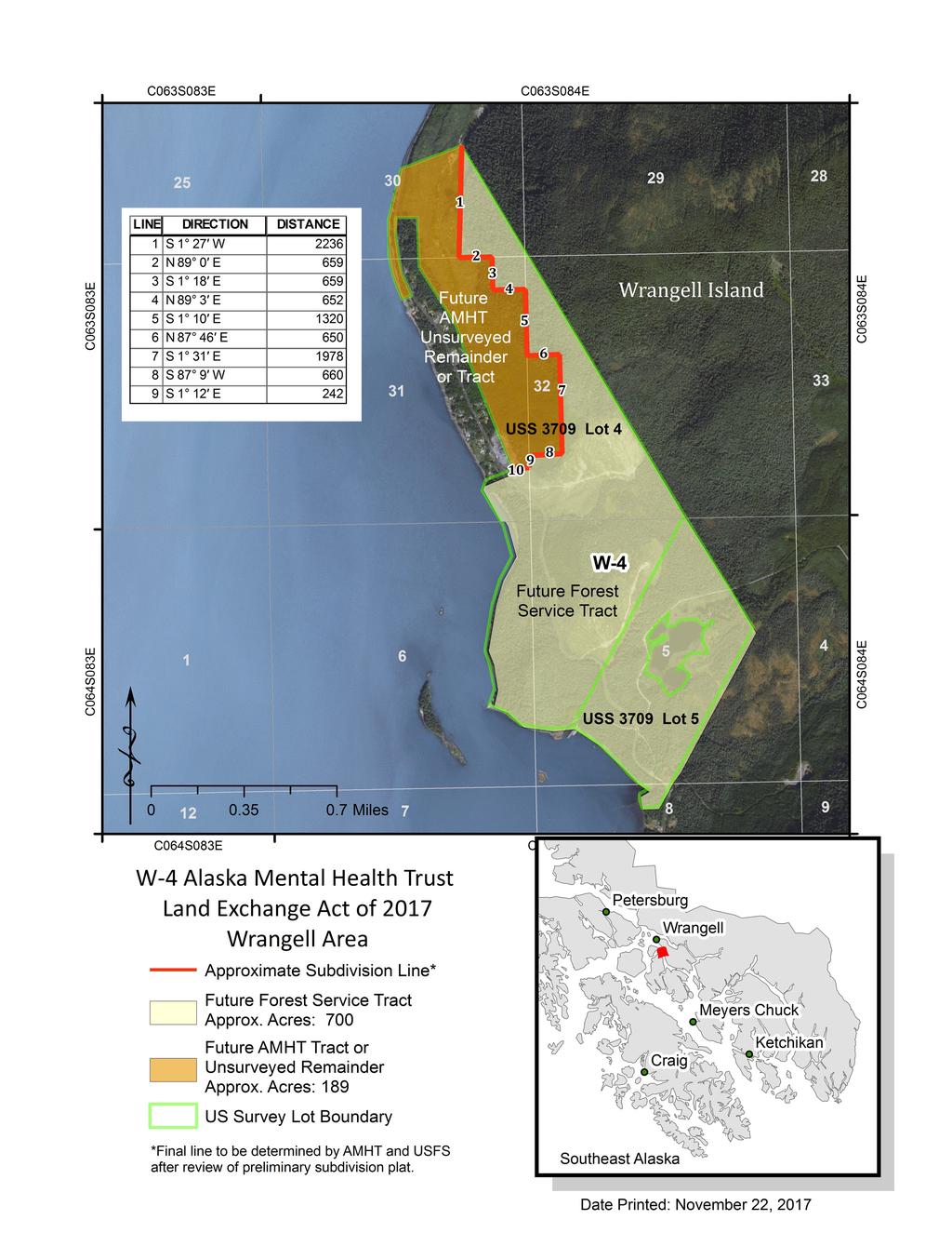
58 WRANGELL PARCEL W4 DESCRIPTION OF WORK All work must be performed under the direct supervision of a land surveyor licensed to practice in the State of Alaska. All work must meet the Wrangell Borough Subdivision standards, specifications, and process. Except for the furnished property below, The Contractor shall furnish all labor, supervision, transportation, equipment, supplies, materials and incidentals necessary to complete the work as specified. This contract is to provide professional surveying services to: OPTION 1 1. Subdivide Lot 4A of U.S. Survey No. 3709, Plat , Wrangell Recording District, Alaska to create a tract of land, "Tract A" approximately 700 acres, as shown on the exhibit map. The remaining portion of Lot 1 may remain as unsurveyed remainder. Tract A, will be deeded to the Forest Service and the remainder tract, approximately 189 acres, will remain in the ownership of the Trust. 2. Draft a preliminiary Subdivision Plat showing the proposed boundaries of the Tracts for review by the Trust and Forest Service. 3. Draft and process a subdivision plat to the standards and specifications of the Wrangell Borough. OPTION 2 1. Clear, mark, post & paint the future Forest Service boundary of Tract A to the U.S. Forest Service Standards as outlined in the Forest Service Region 10, Alaska Region, Tongass and Chugach National Forest Professional Land Survey Services CY Contract Specification. No brush or trees shall be cut on adjoining non-trust Land without written permission from the owner. FURNISHED PROPERTY (1) Corner monuments, signs, and sign posts will be provided as necessary by the Forest Service. RECORD RESEARCH AND ADJOINER NOTIFICATION (1) Record Research. It is the Contractor's responsibility to research all pertinent private and public records to obtain the
59 title and survey history of the subject property and adjoining properties. (2) Adjoiner Notification Prior to the start of fieldwork. The contractor shall contact all adjoining landowner to secure permission to access their lands, and to clear and mark their side of the boundary line. Contact of adjoiners shall be by letter with a self-addressed envelope. A sample Letter is attached. ADDITIONAL SURVEY SPECIFICATIONS In addition to the Borough Subdivision specification the Contractor shall comply with the U.S. Forest Service Standards as outlined in the Forest Service Region 10, Alaska Region, Tongass and Chugach National Forest Professional Land Survey Services CY Contract Specification document attached relating to the following: 1. Trespass Conflicts. If trespass conflicts are found the Contractor shall as soon as posible provide the location, information and photos to the Trust Office. 2. Corner Monuments and Accessories. The contractor shall replace missing or existing monuments in poor condition with the furnished monument posts. If missing, dead or dying Bearing Trees are found the contractor shall establish new ones. 3. Survey Control. Horizontal Control shall be based on the NAD 83 Datum, US Survey feet. An NGS OPUS GPS solution would be acceptable for the basis of horizontal control. The contractor shall determine the Latitude and Longitude (NAD 83) for an original recovered corner monument. 4. Subdivision Plat. The Contractor shall produce a subdivision plat compling with all Borough and DNR platting and subdivision requirements. The plat shall be based on True North, NAD 83. One paper copy of the plat shall be submitted to the Trust Land Office for review at all stages of the platting process 4. Boundary Line Location, Clearing, Marking, Posting, Painting, and permission to perform work on private land. QUALITY CONTROL 1. Contractor shall be responsible for performing an independent self-inspection for quality control. 2. The survey process must include check shots for each monument set or recovered. 3. Quality Control Report documenting Contractors selfinspection.
60 DELIVERIES 1. Original approved mylar subdivision plat. Copies of all Field Notes, Monument Photographs, and Quality Control Reports. Copy of signed Adjoiner Notification letters 2. Copy of any additional reports prepared by the Contractor for the Borough. INSPECTION AND ACCEPTANCE 1. Inspection: The contractor shall, without charge, make available for inspection, originals or copies of such items as field notes, working plats and drawings, material obtained through research, computation sheets, computer printouts, correspondence to and from adjoining landowners, and any other item deemed necessary to insure contract compliance, and verify accomplishments. 2. Acceptance: Acceptance of the work will be made only after the Trust Land Office has inspected and accepted the work and submittals from the Contractor and determined them to fulfill all specifications, terms and conditions of this contract. ATTACHMENTS A) Project Area 1 Map B) Sample Adjoiner Notification letter C) Forest Service Contract Specification.
61
62 CONTRACTOR S LETTERHEAD DATE NAME AND ADDRESS OF ADJOINER Dear NAME, Our firm has been contracted by the Alaska Mental Health Trust Land Office (TLO) to survey and mark your common boundaries. These lands are being exchanged with the United States Forest Service. We plan to be in your area during the week/s of month/s doing this work. There are provisions in the contract to mark your side of the line, if you desire. The Future Forest Service lands are preferred to mark both sides of the boundary line, so Forest users can easily see the limits of National Forest land. Surveying and marking Forest Service boundaries includes the following: 1) Cut and remove brush 3 feet each side of the line. 2) Painting blazes on trees within 3 feet of the line. 3) Boundary line signing. 4) Setting Forest Service corner monuments, where needed, and marking corner accessories, where needed. NOTE: Items 1 and 2 can only be accomplished on private land with the permission of the landowner. Should the need arise, we ask permission to cross your land to gain access to the project. SAMPLE Please fill out the enclosed card concerning project access and boundary line marking, and return the card to our office in the enclosed self-addressed envelope. If you have any information, concerns, or desires you wish to express, please use the Remark s Section of the card, or contact this office at the above address. Thank you for your cooperation. Sincerely, NAME OF CONTRACTOR TITLE OF COMPANY OFFICIAL Enclosures Those items bolded to be filled in/out by the Contractor.
63
64
65
66
67
68
69
70
71
72
73
74
STATE OF ALASKA RFP NUMBER AMENDMENT NUMBER 2
 STATE OF ALASKA RFP NUMBER 180000039 AMENDMENT NUMBER 2 RETURN THIS AMENDMENT TO THE ISSUING OFFICE AT: Department of Natural Resources Support Services Division Procurement Section 550 W. 7 th Avenue,
City of Seward, NE Tuesday, April 19, 2016 Regular Session
 , NE Tuesday, April 19, 2016 Regular Session Item G7 CONSIDERATION OF NOTICE OF LETTER OF INTENT FOR SW WELL #3 - Tim Richtig Administrative Report: This Notice of Intent will allow the City to keep the
The Alaska Mental Health Trust Authority Trust Land Office
 The Alaska Mental Health Trust Authority Trust Land Office BEST INTEREST DECISION Decision to Sell Parcels in the Annual Land Sale Program TLO 2013-33 MH Parcels: See Attachment A In accordance with AS
United States Forest Service Alaska Mental Health Trust Authority Proposed Land Exchange September 4,
 United States Forest Service Tongass National Forest and Mental Health Trust Authority Proposed Land Exchange September, 0 United States Forest Service Mental Health Trust Authority Proposed Land Exchange
Schulte 180 Totaling approximately 180 acres, more or less
 NOTICE OF TIMBERLAND SALE NEVADA COUNTY BID Schulte 180 Totaling approximately 180 acres, more or less BIDS DUE: Thursday, June 7, 2018 Davis DuBose Knight Forestry & Real Estate PLLC has been authorized
BIDS DUE: THURSDAY, MAY 17, 2018
 NOTICE OF TIMBERLAND SALE SEVIER COUNTY BID Tract 1: North 9 th Street Totaling approximately 66 acres, more or less Tract 2: Kerr Mickle Rd. Totaling approximately 100 acres, more or less Tract 3: Hwy
*Note: Due to Funding Restrains, this Bid Proposal may be altered to stay within existing funds.
 Monday, December 11, 2017 TO: From: RE: Registered Land Surveyors Joseph S. Glodowski Waupaca County Surveyor Request for GPS Survey Proposals Waupaca County, Wisconsin is soliciting proposals and qualifications
NOTICE OF TIMBERLAND SALE HOWARD & POLK COUNTIES BID. County Line 160 Totaling approximately 160 acres, more or less
 NOTICE OF TIMBERLAND SALE HOWARD & POLK COUNTIES BID County Line 160 Totaling approximately 160 acres, more or less BIDS DUE: Thursday, May 18 th, 2017, 2:00 PM Davis DuBose Knight Forestry & Real Estate
NOTICE OF TIMBERLAND SALE BY SEALED BID IN CLEVELAND COUNTY, AR. Cleveland County CM acres, more or less
 NOTICE OF TIMBERLAND SALE BY SEALED BID IN CLEVELAND COUNTY, AR Cleveland County CM 80 80 acres, more or less BIDS DUE: Thursday, October 11, 2018 Davis DuBose Knight Forestry & Real Estate LLC has been
MINOR SUBDIVISION PLAT
 CHECKLIST HANCOCK COUNTY AREA PLAN COMMISSION A subdivider shall submit to the Plan Commission office an application and an accompanying plat for a minor subdivision. The plat shall be based on a boundary
Regular Agenda / Public Hearing for Board of Commissioners meeting January 7, 2015
 Rebecca W. Arnold, Commissioner Sara M. Baker, Commissioner Jim D. Hansen, Commissioner Kent Goldthorpe, Commissioner Paul Woods, Commissioner TO: FROM: ACHD Board of Commissioners & Bruce S. Wong, Director
FOR SALE. The bid procedure has ended. The sales price is $152, THE FOLLOWING PROPERTY IS BEING OFFERED FOR SALE BY THE STATE OF NORTH CAROLINA
 FOR SALE The bid procedure has ended. The sales price is $152,000.00 THE FOLLOWING PROPERTY IS BEING OFFERED FOR SALE BY THE STATE OF NORTH CAROLINA Blanch Correctional Institution Location: 2061 High
JACKSONVILLE AVIATION AUTHORITY INVITATION TO BID NUMBER: TIMBER SALE - ARMADILLO VICINITY 2012
 JACKSONVILLE AVIATION AUTHORITY INVITATION TO BID NUMBER: 12-06-44202 TIMBER SALE - ARMADILLO VICINITY 2012 Jacksonville Aviation Authority Procurement Department 14201 Pecan Park Road, 2 nd Floor Jacksonville,
MnDOT Contract No Exhibit B. Scope of Work. Scope of Work
 MnDOT Contract No. 1032993 Contract General Description The purpose of this contract is to provide the State with the survey accurate re-establishment of designated Public Land Survey section boundaries
Final Plat Approval of a Minor Subdivision Application Packet
 Final Plat Approval of a Minor Subdivision Application Packet 1. Application Packet. Be sure to complete and submit all the required materials that are a part of this Application Packet. Failure to do
To provide for the review of the final engineering plans, the subdivision improvement agreement, public dedications, and other legal agreements.
 ARTICLE 5 FINAL PLAT 501 Intent DOUGLAS COUNTY SUBDIVISION RESOLUTION To provide for the review of the final engineering plans, the subdivision improvement agreement, public dedications, and other legal
INFORMATION FOR VENDORS DOING BUSINESS WITH THE CITY OF CORAL SPRINGS, FLORIDA FINANCIAL SERVICES DEPT
 Updated 11/21/2014 VENDOR HANDBOOK INFORMATION FOR VENDORS DOING BUSINESS WITH THE CITY OF CORAL SPRINGS, FLORIDA FINANCIAL SERVICES DEPT./PURCHASING DIVISION 9551 W SAMPLE RD CORAL SPRINGS, FL 33065 TABLE
COMMONWEALTH OF PENNSYLVANIA DEPARTMENT OF GENERAL SERVICES
 COMMONWEALTH OF PENNSYLVANIA DEPARTMENT OF GENERAL SERVICES Bureau of Procurement Forum Place, 6 th Floor 555 Walnut Street Harrisburg, Pennsylvania 17101 TO ALL INTERESTED CONTRACTORS: You are invited
CARROLL COUNTY BUREAU OF DEVELOPMENT REVIEW OFF-CONVEYANCE SUBMITTAL CHECKLIST AND REVIEW FEE SHEET NOTICE: INCOMPLETE SUBMITTALS WILL BE RETURNED
 CARROLL COUNTY BUREAU OF DEVELOPMENT REVIEW OFF-CONVEYANCE SUBMITTAL CHECKLIST AND REVIEW FEE SHEET An off-conveyance submittal shall include all items as specified in Section 103-7 of the Code of Public
CITY OF VERONA. Request for Proposals (RFP) Assessment Services For the Assessment Years
 Assessment Services For the Assessment Years") CITY OF VERONA Request for Proposals (RFP) Assessment Services For the Assessment Years 2019-2022 Due Date: December 28, 2018 by 4:30 p.m. Table of Contents DOCUMENT PAGE Background Information... 2 Specific
CITY OF VERONA Request for Proposals (RFP) Assessment Services For the Assessment Years 2019-2022 Due Date: December 28, 2018 by 4:30 p.m. Table of Contents DOCUMENT PAGE Background Information... 2 Specific
I would like to own a parcel of agricultural land in Alaska. What programs does the State of Alaska have that would allow me to do this?
 Fact Sheet Title: AGRICULTURAL LAND FOR ALASKA Division of Agriculture I would like to own a parcel of agricultural land in Alaska. What programs does the State of Alaska have that would allow me to do
June 1, 2017 BOARD MATTER H - 1 FINAL CONSIDERATION OF STATE TRUST LAND EXCHANGE
 June 1, 2017 BOARD MATTER H - 1 ACTION: AUTHORITY: FINAL CONSIDERATION OF STATE TRUST LAND EXCHANGE W.S. 36-1-107, 36-1-110, and 36-1-111; Board of Land Commissioners Rules and Regulations, Chapter 26,
ADDENDUM #1 Boulder County Housing Authority Housing Quality Standard (HQS) Inspection Services RFP #
 Inspection Services RFP #") ADDENDUM #1 Boulder County Housing Authority Housing Quality Standard (HQS) Inspection Services RFP # 6802-18 January 16, 2018 The attached addendum supersedes the original Information and Specifications
ADDENDUM #1 Boulder County Housing Authority Housing Quality Standard (HQS) Inspection Services RFP # 6802-18 January 16, 2018 The attached addendum supersedes the original Information and Specifications
Certified Federal Surveyor Program Standards of Practice Handbook (Modified February 19, 2013 and November 18, 2014) "Trained to Make a Difference"
 Trained to Make a Difference") Certified Federal Surveyor Program Standards of Practice Handbook (Modified February 19, 2013 and November 18, 2014) "Trained to Make a Difference" Introduction This handbook is designed to document the
Certified Federal Surveyor Program Standards of Practice Handbook (Modified February 19, 2013 and November 18, 2014) "Trained to Make a Difference" Introduction This handbook is designed to document the
Final Plat Approval of a Major Subdivision Application Packet
 Final Plat Approval of a Major Subdivision Application Packet 1. Application Packet. Be sure to complete and submit all the required materials that are a part of this Application Packet. Failure to do
Town of Manchester, Connecticut General Services Department. Request for Qualifications
 Town of Manchester, Connecticut General Services Department Request for Qualifications Purchase of a Senior Citizens Housing Complex 208 North Elm St., Manchester, CT RFQ 16/17-10 Proposals Due: August
FINAL PLAT. Community Development Department 8101 Ralston Road Arvada, Colorado 80002
 FINAL PLAT Community Development Department 8101 Ralston Road Arvada, Colorado 80002 September 2015 FINAL SUBDIVISION PLAT Final Subdivision Plat Review Applications for a Final Plat shall be submitted
Attachment A SPECIAL SURVEY INSTRUCTIONS ALASKA STATE LAND SURVEY NO Sage Subdivision. Authority 11 AAC 53, Survey and Platting Standards
 Attachment A STATE OF ALASKA DEPARTMENT OF NATURAL RESOURCES DIVISION OF MINING, LAND AND WATER SURVEY SECTION 550 W 7 th Ave., SUITE 650 ANCHORAGE, ALASKA 99501-3576 SPECIAL SURVEY INSTRUCTIONS ALASKA
SENATE BILL NO. 88 IN THE LEGISLATURE OF THE STATE OF ALASKA THIRTIETH LEGISLATURE - FIRST SESSION A BILL FOR AN ACT ENTITLED
 BY SENATOR STEDMAN Introduced: /0/ Referred: Resources, Finance SENATE BILL NO. IN THE LEGISLATURE OF THE STATE OF ALASKA THIRTIETH LEGISLATURE - FIRST SESSION A BILL FOR AN ACT ENTITLED 0 "An Act authorizing
Marion County Board of County Commissioners
 Marion County Board of County Commissioners Date: 4/26/26 P&Z: 4/25/26 BCC: 5/17/26 Item Number 160509Z Type of Application Request to rezone the property from the Rural Commercial (RC-1) District to the
Request for Qualifications (RFQ) # On-Call Land Surveying Services November 21, 2018
 # On-Call Land Surveying Services November 21, 2018") Request for Qualifications (RFQ) #2018-54 On-Call Land Surveying Services November 21, 2018 Electronic Submittals are due by 3:00 PM on December 10 th, 2018 The EVERETT HOUSING AUTHORITY is soliciting
Request for Qualifications (RFQ) #2018-54 On-Call Land Surveying Services November 21, 2018 Electronic Submittals are due by 3:00 PM on December 10 th, 2018 The EVERETT HOUSING AUTHORITY is soliciting
City of Fort Lupton Amended Plat Process
 City of Fort Lupton Amended Plat Process Purpose The Amended Plat process is an administrative process to amend a recorded Plat. An Amended Subdivision is an administrative revision to a recorded Subdivision
General Instructions For Surveys and Plans Outside the Provincial Survey System
 May 15, 2018 General Instructions For Surveys and Plans Outside the Provincial Survey System NOTE: This document is a Controller of Surveys Policy manual to be used as a general guideline for the Legal
*** PUBLIC NOTICE ***
 *** PUBLIC NOTICE *** UAS ADMINISTRATIVE SERVICES BUILDING LEASE DISPOSAL PLAN JUNEAU, ALASKA The University of Alaska is offering for lease an approximately 10,000 square foot, one-story commercial and
Steamboat Ski Area Zone Change
 ACTIVITY #: PL-15-1041 Steamboat Ski Area Zone Change HEARING DATES: Planning Commission: 11/19/15 at 6:00 pm Board of County Commissioners 12/7/15 at 1:30 pm pre-hearings: Board of County Commissioners:
Marion County Board of County Commissioners
 Marion County Board of County Commissioners Date: 10/27/2015 P&Z: 10/26/2015 BCC: 11/17/2015 Item Number 151104SU Type of Application Special Use Permit Request Parking of a Commercial Truck in the A-1
Kingwood Forestry Services, Inc. has been authorized to manage the sale of the Womble Silver Road
 K I N G WO O D F O R E S T RY S E RV I CE S, I NC. LISTING #4530 LAND FOR SALE Womble Silver Road Tract Mountain Views near Lake Ouachita Adjoins Ouachita National Forest within 15 miles of Hot Springs
Wheeler Estates LLC Attn: Matthew Colbert PO Box 190 Brookneal, VA May 24, 2017
 Wheeler Estates LLC Attn: Matthew Colbert PO Box 190 Brookneal, VA 24528 May 24, 2017 Invitation to Bid Wheeler Tract Hunt Lease 494.34 +/- acres Land offered for Hunt Lease Located in Campbell County,
Guide to Minor Developments
 Guide to Minor Developments Introduction The Douglas County (DCD) is committed to providing open, transparent application processes to the public. This Guide is provided to assist anyone interested in
REQUEST FOR PROPOSAL
 REQUEST FOR PROPOSAL FOR Spokane Tribe of Indians LDR/COS Certificates YEPA Property And Task Order Contract PROPOSAL NO. FY2011/042 BY SPOKANE TRIBE OF INDIANS PURCHASING/PROPERTY DEPARTMENT 6195 FORD/WELLPINIT
Prepared by Office of Procurement and Real Property Management. This replaces Administrative Procedure No. A8.215 dated November 2012 A8.
 Prepared by Office of Procurement and Real Property Management. This replaces Administrative Procedure No. A8.215 dated November 2012 A8.215 A8.215 Definitions A8.200 Procurement October 2013 The words
$834, /- Acres. Chesterfield County, SC REDUCED. National Land Realty 3610 Landmark Drive Ste G Columbia, SC
 lakefront recreational tract 238.3 +/- Acres Chesterfield County, SC $834,050 REDUCED National Land Realty 3610 Landmark Drive Ste G Columbia, SC 29204 www.nationalland.com Jason Burbage Office: 855.384.5263
Guide to Combined Preliminary and Final Plats
 Guide to Combined Preliminary and Final Plats Introduction The Douglas County is committed to providing open, transparent application processes to the public. This Guide is provided to assist anyone interested
Chapter 8. Competitive Sealed Bidding: Addenda, Modifications, and Withdrawals
 Chapter 8. Competitive Sealed Bidding: Addenda, Modifications, and Withdrawals Summary This chapter addresses situations in which the invitation for bids is revised by an addendum or the bid submitted
$89, /- Acres. Bamberg County, SC REDUCED. National Land Realty 3610 Landmark Drive Ste G Columbia, SC
 olar@hwy@spq hunting@tract 50 +/- Acres Bamberg County, SC $89,000 REDUCED National Land Realty 3610 Landmark Drive Ste G Columbia, SC 29204 www.nationalland.com Stan Swofford Office: 855.384.5263 Cell:
REQUEST TO SUBMIT OFFERS FOR THE LEASING OF SCHOOL BOARD PREMISES 30+/- ACRES- WEST AREA VACANT AGRICULTURAL PARCEL
 SCHOOL BOARD OF PALM BEACH COUNTY REQUEST TO SUBMIT OFFERS FOR THE LEASING OF SCHOOL BOARD PREMISES 30+/- ACRES- WEST AREA VACANT AGRICULTURAL PARCEL RELEASE DATE: November 16, 2018 INTRODUCTION 1. This
Methods of Legal Description Metes and Bounds The Rectangular Survey System Recorded Plat Method Describing Elevation
 9 Legal Descriptions Methods of Legal Description Metes and Bounds The Rectangular Survey System Recorded Plat Method Describing Elevation METHODS OF LEGAL DESCRIPTION There are many common ways of describing
PRELIMINARY PLAT CHECK LIST
 PRELIMINARY PLAT CHECK LIST Name of Proposed Subdivision: The following items must be included with the initial submittal of a Preliminary Plat: Application, filled out completely Project Narrative Pre-application
BOARD OF ZONING APPEALS CASE SUMMARY FOR VARIANCE REQUEST. 325 Veterans Road
 BOARD OF ZONING APPEALS CASE SUMMARY FOR VARIANCE REQUEST 325 Veterans Road April 11, 2017 at 10:00 A.M. City Council Chambers, 1737 Main Street, 3 rd Floor Columbia, South Carolina Case Number: 2017-0031-V
DEVIL S CANYON TRACT
 P.O. Box 65 No. 4 Executive Circle Arkadelphia, AR 71923 (870)246-5757 FAX 1-870-246-3341 E-mail: arkadelphia@kingwoodforestry.com Other Kingwood Locations: P.O. Box 1290 145 Greenfield Drive Monticello,
HUNTINGDON SPECIAL SCHOOL DISTRICT PROCUREMENT PLAN CHILD NUTRITION PROGRAM
 HUNTINGDON SPECIAL SCHOOL DISTRICT PROCUREMENT PLAN CHILD NUTRITION PROGRAM This procurement plan contained on the following pages 1 through 10 will be implemented on July 1, 2016 from that date forward
REQUIREMENTS FOR ALL INSTRUMENTS OF CONVEYANCE IN HARDIN COUNTY, OHIO
 REQUIREMENTS FOR ALL INSTRUMENTS OF CONVEYANCE IN HARDIN COUNTY, OHIO Effective Date: Michael L. Smith, P.E., P.S. Hardin County Engineer Michael T. Bacon Hardin County Auditor 1 I. GENERAL In compliance
AMENDED AGENDA BLUFFDALE CITY BOARD OF ADJUSTMENT. October 4, 2016
 AMENDED AGENDA BLUFFDALE CITY BOARD OF ADJUSTMENT October 4, 2016 Notice is hereby given that the Bluffdale City Board of Adjustment will hold a public meeting Tuesday, October 4, 2016, at the Bluffdale
STANDARDS GOVERNING CONVEYANCES OF REAL PROPERTY
 STANDARDS GOVERNING CONVEYANCES OF REAL PROPERTY Hancock County, Ohio Charity A. Rauschenberg, Hancock County Auditor Steven C. Wilson, Hancock County Engineer Revised: March 1, 2007 TRANSFER AND CONVEYANCE
STATE OF ALASKA DEPARTMENT OF NATURAL RESOURCES DIVISION OF MINING, LAND, AND WATER FINAL FINDING AND DECISION
 STATE OF ALASKA DEPARTMENT OF NATURAL RESOURCES DIVISION OF MINING, LAND, AND WATER FINAL FINDING AND DECISION of a Land Offering in the Fairbanks North Star Borough DMVA Tracts, ADL 420894 Public Access
FINAL MAP PLAN CHECK
 Engineering Division 201 North Broadway, Escondido, CA 92025 (760) 839-4651, FAX (760) 839-4597 FINAL MAP PLAN CHECK To: Date: Project: Address: Check No: Attn: VIA: The attached FINAL MAP has been reviewed
CITY OF LANCASTER CITY ENGINEERING DIVISION FINAL MAP SUBMITTAL PACKAGE FINAL MAP APPLICATION
 CONTENTS Page 1 - Final Map Application Page 2 - Financial Interest Disclosure Page 3-1 st Submittal Checklist Page 4 - Required Easement Tracking Sheet Page 5 - Easement Submittal Requirements Checklist
SUBDIVISION APPLICATION
 SUBDIVISION APPLICATION Preliminary Plat Minor Plat Final Plat Amended Plat Applicant Name: Owner (if different from applicant) Name: Company: Company: Address: Address: City, State, Zip City, State, Zip
REQUEST FOR PROPOSAL RFP # TOC17-001
 REQUEST FOR PROPOSAL RFP # TOC17-001 April 25, 2017 157 NW Columbia Avenue P. O. Box 183 Chapin, SC 29036 Tel.: (803) 345-2444 Fax: (803) 345-0427 April 25, 2017 REQUEST FOR PROPOSAL RFP # TOC17-001 The
Instructions for Maps to Accompany Proof of Appropriation and Beneficial Use of Ground Water
 Instructions for Maps to Accompany Proof of Appropriation and Beneficial Use of Ground Water Part II of the Proof of Appropriation (Form U.W. 8) All maps to accompany proof of appropriation and beneficial
AGENDA ITEM # CITY OF FERNLEY PLANNING COMMISSION AGENDA REPORT. Planning Commission. Melinda Bauer, Assistant Planner
 CITY OF FERNLEY PLANNING COMMISSION AGENDA REPORT AGENDA ITEM # TO: REPORT BY: REVIEWED BY: Planning Commission Melinda Bauer, Assistant Planner Tim Thompson, AICP Planning Director tthompson@cityoffernley.org
COUNTY OF TANEY, MISSOURI
 COUNTY OF TANEY, MISSOURI REQUEST FOR BID For COUNTY TAX SALE Release Date: February 22, 2012 Submittal Deadline: March 22, 2012 Not later than 9:00 AM, Central Time Taney County Purchasing Ron Erickson,
Contract Risk Allocation Working Group. Recommended Practice for Managing Risks in Contracts Involving OWNER-FURNISHED PROPERTY
 Contract Risk Allocation Working Group Recommended Practice for Managing Risks in Contracts Involving OWNER-FURNISHED PROPERTY INTRODUCTION This document is a guideline for managing risks in contracts
WYANDOT COUNTY BASIC STANDARDS FOR THE APPROVAL OF REAL ESTATE DEED TRANSFERS & LAND CONTRACT AGREEMENTS
 GENERAL In compliance with Section 315.251 of the Ohio Revised Code, the County Auditor and the County Engineer have adopted these written standards governing the conveyance of real property in Wyandot
ADDENDUM NO. 4. Modification to Part I, Section 2.0, Item J of the Project Book
 ADDENDUM NO. 4 DATE: January 9, 2018 Invitation for Bid: M180011681 Shockoe Bottom Cobblestone Rehabilitation Phase I DATED: December 12, 2017 RECEIPT DATE: January 22, 2018 at 2:30 p.m. EST (Changed)
October 31, Mailing Address: 4886 Chisholm Road Florence, AL Phone: (256) Fax: (256)
 Fax: (256)") October 31, 2018 Dear Timber Purchaser: You are invited to submit a bid on the attached timber sale. To assist with the preparation of your bid, we have enclosed the following: 1) Timber Sale Synopsis,
October 31, 2018 Dear Timber Purchaser: You are invited to submit a bid on the attached timber sale. To assist with the preparation of your bid, we have enclosed the following: 1) Timber Sale Synopsis,
TEXAS GENERAL LAND OFFICE PROCUREMENT GUIDANCE FOR RECIPIENTS AND SUBRECIPIENTS UNDER 2 CFR PART 200 (UNIFORM RULES)
") TEXAS GENERAL LAND OFFICE COMMUNITY DEVELOPMENT & REVITALIZATION PROCUREMENT GUIDANCE FOR RECIPIENTS AND SUBRECIPIENTS UNDER 2 CFR PART 200 (UNIFORM RULES) This checklist will assist the Texas General
TEXAS GENERAL LAND OFFICE COMMUNITY DEVELOPMENT & REVITALIZATION PROCUREMENT GUIDANCE FOR RECIPIENTS AND SUBRECIPIENTS UNDER 2 CFR PART 200 (UNIFORM RULES) This checklist will assist the Texas General
20 Acres Lumpkin Farmland
 20 Acres Lumpkin 20.25 +/- Acres ($2,444/acre) Stewart County, GA $49,500 Address: 7000 Green Grove Road Lumpkin, GA 31815 Location: From the corner of US HWY 27 and Green Grove Rd, go west for three miles
County Tax Sale PLEASE MARK YOUR ENVELOPE "SEALED BID # RETURN ONE (1) ORIGINAL AND THREE (3) COPIES TO:
 ORIGINAL AND THREE (3) COPIES TO:") REQUEST FOR BID No. 201303-216 TANEY COUNTY MISSOURI Purchasing Department 132 David Street / P. O. Box 1630 Forsyth, Missouri 65653 Attn: Ron Erickson, Director of Purchasing Phone: 417-546-7281 / FAX:
REQUEST FOR BID No. 201303-216 TANEY COUNTY MISSOURI Purchasing Department 132 David Street / P. O. Box 1630 Forsyth, Missouri 65653 Attn: Ron Erickson, Director of Purchasing Phone: 417-546-7281 / FAX:
INVITATION TO BID LETTER
 FARWELL AREA SCHOOLS Steve Scoville Superintendent Dorothy Boge Business Manager (989) 588-9917 Fax (989) 588-6440 399 East Michigan Street, Farwell, Michigan 48622 INVITATION TO BID LETTER March 6, 2019
Lower Rio Grande Valley Development Council. Invitation to Bid (ITB): Graphic Design Training Services. office. 301 West Railroad Weslaco, Texas 78596
: Graphic Design Training Services. office. 301 West Railroad Weslaco, Texas 78596") The Lower Rio Grande Valley Development Council (LRGVDC) Invitation to Bid (ITB): Graphic Design Training Services. Quotes Due Not Later than: Issuing Office: Friday, July 15th, 2016 at 12:00 Noon at the
The Lower Rio Grande Valley Development Council (LRGVDC) Invitation to Bid (ITB): Graphic Design Training Services. Quotes Due Not Later than: Issuing Office: Friday, July 15th, 2016 at 12:00 Noon at the
Chapter 5. Competitive Sealed Bidding: Procedure
 Chapter 5. Competitive Sealed Bidding: Procedure Summary This chapter provides an overview of the procedure for procuring goods and nonprofessional services using the competitive sealed bidding procedure.
AMENDED AGENDA BLUFFDALE CITY BOARD OF ADJUSTMENT. January 24, 2017
 AMENDED AGENDA BLUFFDALE CITY BOARD OF ADJUSTMENT January 24, 2017 Notice is hereby given that the Bluffdale City Board of Adjustment will hold a public meeting Tuesday, January 24, 2017, at the Bluffdale
Plats and subdivisions; mapping requirements. (a) Size Requirements. All land plats presented to the register of deeds for recording in the
 Size Requirements. All land plats presented to the register of deeds for recording in the") 47-30. Plats and subdivisions; mapping requirements. (a) Size Requirements. All land plats presented to the register of deeds for recording in the registry of a county in North Carolina after September
47-30. Plats and subdivisions; mapping requirements. (a) Size Requirements. All land plats presented to the register of deeds for recording in the registry of a county in North Carolina after September
CONVEYANCE - COMMONWEALTH PROPERTY IN THE BOROUGH OF EAST STROUDSBURG, MONROE COUNTY Act of Jul. 1, 2016, P.L., No. 65 Cl.
 CONVEYANCE - COMMONWEALTH PROPERTY IN THE BOROUGH OF EAST STROUDSBURG, MONROE COUNTY Act of Jul. 1, 2016, P.L., No. 65 Cl. 85 An Act Authorizing the Department of General Services, with the approval of
MAP CHECKLIST (Rev 02/13)
") Note: [ ] 1 is Gov. Code, [ ] 2 is BP Code, [ ] 3 is S.M.Co. Ord. MAP CHECKLIST (Rev 02/13) COUNTY OF SAN MATEO TRACT NO. INITIAL SUBMISSION Final Map Conditional Approval Letter and Approved Tentative
Note: [ ] 1 is Gov. Code, [ ] 2 is BP Code, [ ] 3 is S.M.Co. Ord. MAP CHECKLIST (Rev 02/13) COUNTY OF SAN MATEO TRACT NO. INITIAL SUBMISSION Final Map Conditional Approval Letter and Approved Tentative
Section I General Information
 General Information Table of Contents A. Introduction... I-2 1. Purpose... I-2 2. Scope... I-2 3. Maintenance... I-3 4. Units... I-3 B. Public Relations... I-3 1. General Public... I-3 2. Property Owners...
GENERAL ASSEMBLY OF NORTH CAROLINA SESSION 2017 H 1 HOUSE BILL 454* Short Title: Surveying and Plat Recording Changes. (Public)
") GENERAL ASSEMBLY OF NORTH CAROLINA SESSION H 1 HOUSE BILL * Short Title: Surveying and Plat Recording Changes. (Public) Sponsors: Referred to: Representative Arp. For a complete list of sponsors, refer
GENERAL ASSEMBLY OF NORTH CAROLINA SESSION H 1 HOUSE BILL * Short Title: Surveying and Plat Recording Changes. (Public) Sponsors: Referred to: Representative Arp. For a complete list of sponsors, refer
220 S.E. Green Street Lee s Summit, MO RFP # RE TITLE SIGNATURE PAGE REQUEST FOR PROPOSAL NO.RE
 220 S.E. Green Street Lee s Summit, MO 64063 816.969.1403 RFP # RE 2016 02 TITLE SIGNATURE PAGE REQUEST FOR PROPOSAL NO.RE 2016 02 The City of Lee's Summit will accept submitted sealed proposals through
SECTION 6 - APPROVAL OF PLATS. Whenever any subdivision of land is proposed, and before any permit for the
 SECTION 6 - APPROVAL OF PLATS 6-1 APPROVAL REQUIRED BEFORE SALE Whenever any subdivision of land is proposed, and before any permit for the erection of a structure shall be granted, the subdivider or his
Requirements for All Instruments of Conveyance in Logan County, Ohio
 Requirements for All Instruments of Conveyance in Logan County, Ohio Effective Date: April 11, 1997 It is the intent of these requirements to provide a standard method of checking legal descriptions for
Marion County Board of County Commissioners
 Marion County Board of County Commissioners Date: 12/2/25 P&Z: 11/30/25 BCC: 12/16/25 Amendment No: (20)151209Z Type of Application Rezoning Request P-MH (Mobile Home Park) to B-2 (Community Business)
Limited Liability Report
 Limited Liability Report ISSUED BY Limited Liability Report First American Title Insurance Company REPORT NUMBER File No.: 0239-2869660 Ref No.: 15860 Glacier Highway To: City and Borough of Juneau Lands
*** PUBLIC NOTICE ***
 *** PUBLIC NOTICE *** UNIVERSITY OF ALASKA INDUSTRIAL AVENUE OFFICE BUILDING DISPOSAL PLAN FAIRBANKS, ALASKA The University of Alaska is offering for sale a 12,000 square foot 2-story office building located
COMPETITIVE BIDDING NOTICE INVITATION TO BID. The County of Waller proposes to purchase the following items on competitive bid: HYDRATED LIME
 COMPETITIVE BIDDING NOTICE INVITATION TO BID The County of Waller proposes to purchase the following items on competitive bid: HYDRATED LIME Bids will be received by the Waller County Auditor, Alan Younts,
BOROUGH OF HELLERTOWN 685 Main St., Hellertown PA Phone: Fax:
 SUBDIVISION / LAND DEVELOPMENT REVIEW CHECKLIST Subdivision / Land Development Preliminary Plan Preliminary Plan Checklist A scaled plan not less that 1 = 100 feet (422.01) Proposed subdivision name or
MINOR SUBDIVISION PLAT
 MINOR SUBDIVISION PLAT Community Development Department 8101 Ralston Road Arvada, Colorado 80002 MINOR SUBDIVISION PLAT Subdivisions consisting of five (5) or fewer lots are eligible for the minor subdivision
Zoning Board of Adjustment Meeting Date: June 1, 2016 BOAV16:06 Agenda Item #5
 City of Bastrop Agenda Information Sheet: Zoning Board of Adjustment Meeting Date: June 1, 2016 BOAV16:06 Agenda Item #5 Public Notice Description: Consideration and possible action on a Variance to Zoning
Marlboro County School District
 Marlboro County School District REQUEST FOR BIDS RFB-16/17-4 MCHS Cooling Tower Parts & Installation Purpose: The purpose for this Request for Bids is to secure a contractor to provide equipment and repair
FINAL PLAT APPLICATION
 FINAL PLAT APPLICATION (Page 1 of 3) LEGAL OWNER(s): NAME: STREET ADDRESS OWNER(s): CITY, STATE, ZIP CODE: PHONE NUMBER: BILLING ADDRESS: NAME OF ENGINEER/SURVEYOR: Engineer/Surveyor Address, Phone: PROPERTY
UCF FACTS MADE PART OF THIS SOLICITATION
 UCF FACTS MADE PART OF THIS SOLICITATION 1. Vendor Question: Please provide prior bid tabulations, invoices and Bill of Ladings UCF Answer: Please see the bottom of this addendum for UCF specific information.
We are Listening. Public Hearing
 We are Listening. Public Hearing Thursday, June 14, 218 5: PM Council Chambers 355 Main Street West St. Paul, MB What is CU 12, 218 about? The purpose of this conditional use application is to allow a
MINOR SUBDIVISION PLAT
 MINOR SUBDIVISION PLAT Community Development Department 8101 Ralston Road Arvada, Colorado 80002 September 2015 MINOR SUBDIVISION PLAT Subdivisions consisting of five (5) or fewer lots are eligible for
DUSTY RHODES HAMILTON COUNTY AUDITOR WILLIAM W. BRAYSHAW HAMILTON COUNTY ENGINEER
 DUSTY RHODES HAMILTON COUNTY AUDITOR www.hamiltoncountyauditor.org WILLIAM W. BRAYSHAW HAMILTON COUNTY ENGINEER www.hamilton-co.org/engineer As Adopted Under Ohio Revised Code Section 319.203 Effective
FOR SALE THE FOLLOWING PROPERTY IS BEING OFFERED FOR SALE BY THE STATE OF NORTH CAROLINA BRISTOL DRIVE, STATESVILLE, NC SPO FILE #049-WF
 FOR SALE THE FOLLOWING PROPERTY IS BEING OFFERED FOR SALE BY THE STATE OF NORTH CAROLINA BRISTOL DRIVE, STATESVILLE, NC SPO FILE #049-WF Open for bids beginning April 24 ending on May 8, 2017. LOCATION:
B. The proposed parcel(s) of land shall be in compliance with the current zoning requirements.
 of land shall be in compliance with the current zoning requirements.") SECTION 14-900 SUBDIVISION EXEMPTION 14-901 INTENT To establish criteria and a review process whereby the Board of County Commissioners may grant Exemptions from the definition of the terms subdivision
SECTION 14-900 SUBDIVISION EXEMPTION 14-901 INTENT To establish criteria and a review process whereby the Board of County Commissioners may grant Exemptions from the definition of the terms subdivision
Invitation For Bid IFB 2895
 Purchasing and Financial Control P.O. Box 13145 Roanoke, VA 24031 (540) 853-2906 FAX (540) 853-1679 July 21, 2015 Invitation For Bid IFB 2895 Notice is hereby given of the intention of the School Board
Request for Proposals For Outdoor Advertising - Billboards. At the Following Locations. TelPosta Towers: Roof Top on Tower 2 (Kenyatta Avenue)
") Request for Proposals For Outdoor Advertising - Billboards At the Following Locations On TelPosta Towers: Roof Top on Tower 2 (Kenyatta Avenue) Roof Top on Tower 3 (Nyayo House) 5th Floor Balcony Facing
Request for Proposals For Outdoor Advertising - Billboards At the Following Locations On TelPosta Towers: Roof Top on Tower 2 (Kenyatta Avenue) Roof Top on Tower 3 (Nyayo House) 5th Floor Balcony Facing
COMPETITIVE BIDDING NOTICE INVITATION TO BID. The County of Waller proposes to purchase the following items on competitive bid:
 COMPETITIVE BIDDING NOTICE INVITATION TO BID The County of Waller proposes to purchase the following items on competitive bid: HAULING SERVICES FOR GRAVEL & AGGREGATE MATERIAL Bids will be received by
MINOR SUBDIVISION APPLICATION
 Planning and Development 510 N. Baker St. Mount Dora, FL 32757 352-735-7112 Fax: 352-735-7191 plandev@cityofmountdora.com Date: Project Name: MINOR SUBDIVISION APPLICATION 1. Applicant s Name: 2. Property