Group Break Out. What, if anything, sends up a red flag? What does the lotting along the North and South centerline suggest? What are your next steps?
|
|
|
- Warren Cobb
- 5 years ago
- Views:
Transcription
1 What is the NW ¼?
2 What is the NW ¼? You are hired to survey your client s property in Section 8. His deed says NW ¼ Section 8, T. 40 S., R. 07 E. According to the county, it is Tax Lot 700. He gives you the Assessor s plat for reference:
3 T. 40 S., R 07 E.

4
5 Group Break Out What, if anything, sends up a red flag? What does the lotting along the North and South centerline suggest? What are your next steps?
6 Private Plat
7 Private Plat, North Side
8 Private Plat, East Side
9 Private Plat, South Side
10 Private Plat, West Side

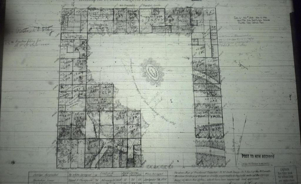
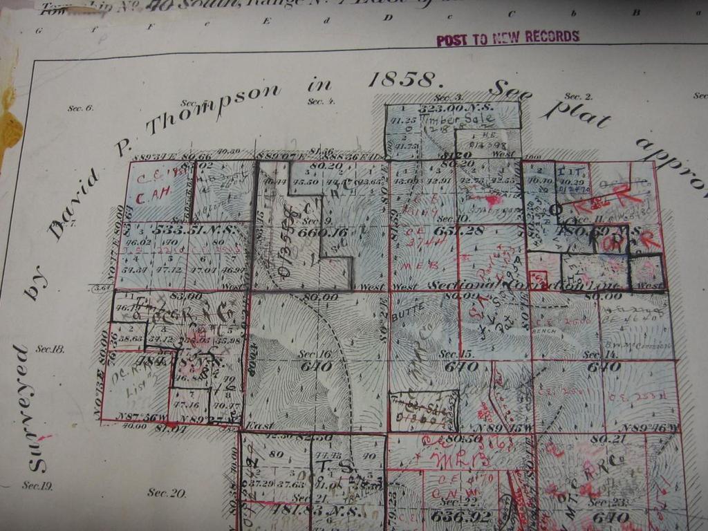
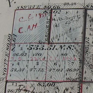
11 GLO Plat #1

12 GLO Plat #1 Sec. 8

13 GLO Plat #2

14 GLO Plat #2 Sec. 8

15 BLM Plat #3
16 BLM Plat #3 Sec. 8
17 Information What information do you know for sure? What other information do you think you might need? Where might you go to get more information? Can you make a decision on how the section should be subdivided without any more information?

18
19 Group Break Out You go out on the ground to start your survey, and you run into a BLM forester, who tells you that the lots 1 and 2 are federal land. What sources of information can you use to help you confirm or deny this?
20 BLM Master Title Plat
21 Master Title Plat Sec. 8

22 Historical Index pg 1
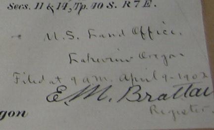
23 Historical Index pg 2

24 Historical Index pg 3

25 Historical Index pg 4
26 Historical Index pg 5

27 Historical Index pg 6

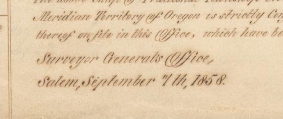
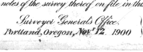
28 Historical Index pg 7

29 Historical Index pg 8

30 NW ¼ Patent

31 NW ¼ patent date April 9, 1901

32 NW ¼ Description North West quarter One hundred and sixty acres
33
34 Patents What is the date of the patent? What is the description on the patent? How do those dates correspond with the dates of the official survey plat(s)?
35 Plat Dates First survey: September 7, 1858 Second survey: November 12, 1900 NW ¼ Patent; April 9, 1901 NE ¼ Patent; August 29, 1907 Third survey: June 15, 1984

36
37 Group Break Out Do these patent dates lead you to a firm conclusion? Is there any other information you might need?
38
39

40
41
42
43
44 Discussion NW4 was patented based on the original acres The 1900 survey identified an excess (more than 5% of the patented 160 acres) between the 1858 survey and protraction of the NW ¼ and the 1900 completion survey of the NE ¼ in section 8. Draftsmen creates lots 1 thru 7 in section 8 to account for this 5%. The 1901 patent of the NW ¼ listed 160 acres, not acres. Patent was issued similarly to all other patents issued on the original survey. Including those in other sections which were only partially returned in the original survey (SW 17, 21, and 34). At the time of patent, the entrymen would locate themselves in accordance with the original survey.
45 1973 Manual Bona Fide Rights Bona fide rights are those acquired in good faith under the law. A resurvey can affect bona fide rights only in the matter of position or location on the earth's surface. The surveyor will be concerned only with the question of whether the lands covered by such rights have been actually located in good faith. Other questions of good faith (such as priority of occupation, possession, continuous residence, value of improvements and cultivation) do not affect the problem of resurvey except as they BONA help FIDE to define RIGHTS the position OF CLAIMANTS of the original survey.
46 2009 Manual Bona Fide Rights 5-26 Arbitrary location (with no reliance on at least one federal monument) cannot qualify as having established a bona fide right as to location.
47 Discussion (cont) NE4, SE4, SW4 were patented based on the completion survey The 1901 patent of the NE 1/4, listed the acreage correctly as 160 acres; The 1904 patent of the SW ¼ listed the combined acreage of lots 3, 4 and 5 and the aliquot NE ¼ of the SW ¼ correctly as acres; The 1906 patent of the SE 1/4, listed the combined acreage of lots 6 and 7 and the aliquot N ½ of the SE ¼ correctly as acres; Pat ac Pat ac Pat ac
48 Discussion (cont) At the time of patent, the entrymen would locate themselves with the evidence of the original survey. It was not until 1984 that physical evidence was available for the NW corner of the NE4 by official dependent resurvey. Pat ac Pat ac Pat ac
49
50 WHAT DO YOU BELIEVE!?!
Subdivision of Fractional Sections ISPLS 2017
 Subdivision of Fractional Sections ISPLS 2017 Dennis J. Mouland, PLS Instructor Witness Tree Consulting, Inc., 2011, All Rights Reserved Course Objectives Understand the definition of a fractional section
Certified Federal Surveyor Program Assignment #6, Feedback
 Certified Federal Surveyor Program Assignment #6, Feedback Now that you have completed Assignment #6, take a few minutes to review the comments below. We have tried to identify items of special importance,
Preparing Property descriptions D A V I D T. BUTCHER, PLS
 Preparing Property descriptions D A V I D T. BUTCHER, PLS Who can prepare property descriptions? 327.272. Practice as professional land surveyor defined. 1. A professional land surveyor shall include any
CFedS Outline Unit 1. Course 1: History, Records & Administrative Systems
 CFedS Outline Unit 1 Course 1: History, Records & Administrative Systems History of U.S. Surveying Historical Perspective Similarities in Surveying Seniority of Calls Lack of Standards A National Debt
BUREAU OF LAND MANAGEMENT. Fractional Sections. With John Farnsworth and Belle Craig C A D A S T R A L S U R V E Y
 BUREAU OF LAND MANAGEMENT Fractional Sections With John Farnsworth and Belle Craig 2009 C A D A S T R A L S U R V E Y Fractional Sections There are two types of fractional sections referenced in the 1973
DISCREPANCIES IN THE OFFICIAL RECORD
 DISCREPANCIES IN THE OFFICIAL RECORD The The lines The corners lengths marked set of by the the section Surveyor General lines are are are unchangeable. unchangeable 1. Inconsistencies on the face of the
Printable Lesson Materials
 Printable Lesson Materials Print these materials as a study guide These printable materials allow you to study away from your computer, which many students find beneficial. These materials consist of two
P.F. WOOD, APPELLANT, V. C. MANDRILLA, RESPONDENT. SAC. NO SUPREME COURT
 Supreme Court of California,Department Two. 167 Cal. 607 {Cal. 1914) WOOD V. MANDRILLA P.F. WOOD, APPELLANT, V. C. MANDRILLA, RESPONDENT. SAC. NO. 2089. SUPREME COURT OF CALIFORNIA,DEPARTMENT TWO. APRIL
Certified Federal Surveyor Program Assignment #3, Feedback
 Certified Federal Surveyor Program Assignment #3, Feedback Now that you have completed Assignment #3, take a few minutes to review the comments below. We have tried to identify items of special importance,
Where the 2009 Manual is Silent
 Where the 2009 Manual is Silent A seminar for the Professional Land Surveyor Dennis J. Mouland, PLS, Instructor PLSO 2014 A long history of Manuals Original contracts and instructions 1851 Oregon Instructions
THE THREE MILE METHOD OF SURVEYING IN THE UTE MERIDIAN. Mesa County, Colorado
 THE THREE MILE METHOD OF SURVEYING IN THE UTE MERIDIAN Mesa County, Colorado Mesa County, located at the confluence of the Grand (Colorado) and Gunnison Rivers on the Western Slope, is a very unique area
JAMES R. BIERSACK IBLA
 JAMES R. BIERSACK IBLA 88-260 Decided January 29, 1991 Appeal from separate decisions of the Eastern States Office, Bureau of Land Management, rejecting applications filed under the O'Konski Act (ES 35936),
Boundary. Survey Part 1. The Tepusquet. >> By Justin Height, PS
 The Tepusquet Boundary Survey Part 1 he JET Investment Trust is the owner of 900 acres of rugged, undeveloped land in the Tepusquet Canyon area, approximately 10 miles east of Santa Maria, California.
CITY OF LEE S SUMMIT MINOR PLAT PROCESS. Purpose of Minor Plats
 MINOR PLAT PROCESS Purpose of Minor Plats The City of Lee s Summit requires that all property be platted before a building permit is issued. Platting involves the subdivision of land into lots or tracts.
Center of Section. Computed or Monumented Position. Review and Commentary
 Center of Section Computed or Monumented Position Review and Commentary Center of Section Center of section defined by law for more than 200 years Computed position vs monumented position Examine the state
CHECK LIST FOR REVIEW OF SURVEY PLATS FOR COMPLIANCE WITH MISSOURI MINIMUM STANDARDS FOR PROPERTY BOUNDARY SURVEYS NAME OF SURVEYOR: DATE OF SURVEY:
 CHECK LIST FOR REVIEW OF SURVEY PLATS FOR COMPLIANCE WITH MISSOURI MINIMUM STANDARDS FOR PROPERTY BOUNDARY SURVEYS NAME OF SURVEYOR: DATE OF SURVEY: REVIEWED BY: DATE: DESCRIPTION OF SURVEY: GENERAL LAND
Oakland County Michigan Register of Deeds Plat Engineering, GIS, & Remonumentation Dept. Ph: (248) Fax (248)
 Fax (248)") Oakland County Michigan Register of Deeds Plat Engineering, GIS, & Remonumentation Dept. Ph: (248)-858-1447 Fax (248)-858-7466 Requirements Needed for Final Plat Approval No. General Requirements. 1 Routing
Oakland County Michigan Register of Deeds Plat Engineering, GIS, & Remonumentation Dept. Ph: (248)-858-1447 Fax (248)-858-7466 Requirements Needed for Final Plat Approval No. General Requirements. 1 Routing
CITY OF HIAWATHA, IOWA TOWN VILLAGE CENTER URBAN REVITALIZATION PLAN. for the TOWN VILLAGE CENTER URBAN REVITALIZATION AREA
 CITY OF HIAWATHA, IOWA TOWN VILLAGE CENTER URBAN REVITALIZATION PLAN for the TOWN VILLAGE CENTER URBAN REVITALIZATION AREA 2018 1 INTRODUCTION The Urban Revitalization Act, Chapter 404 of the Code of Iowa,
List of Lands Available for Taxes
 List of Lands Available for Taxes ****Florida Statute 197.502 Application for obtaining tax deed by holder of tax sale certificate; fees. (7) On county-held or individually held certificates for which
WYANDOT COUNTY BASIC STANDARDS FOR THE APPROVAL OF REAL ESTATE DEED TRANSFERS & LAND CONTRACT AGREEMENTS
 GENERAL In compliance with Section 315.251 of the Ohio Revised Code, the County Auditor and the County Engineer have adopted these written standards governing the conveyance of real property in Wyandot
89.71 Acres, m/l, in 2 Parcels Marion County, IA. Agency Hertz Real Estate Services, Inc. and their representatives are Agents of the Seller.
 LAND AUCTION 89.71 Acres, m/l, in 2 Parcels Marion County, IA Date: Thur., Oct. 20, 2016 Time: 10:00 a.m. Auction Site: Cobblestone Hotel & Suites Address: 1212 Eric Drive Knoxville, IA 50138 Auction Information
Interested Person Leah Dawkins, Land Use Services /
 Date: November 16, 2018 To: From: Interested Person Leah Dawkins, Land Use Services 503-823-7830 / Leah.Dawkins@portlandoregon.gov NOTICE OF A TYPE IIx PROPOSAL IN YOUR NEIGHBORHOOD Development has been
Presented by: Michael G. Geier, PLS Snyder & Associates, Inc.
 Presented by: Michael G. Geier, PLS Snyder & Associates, Inc. Background Society of Land Surveyors of Iowa (SLSI) Iowa County Recorders Association (ICRA) Iowa Land Records (ILR) Started a process three
WHEN DANIEL BOONE led pioneers across the
 Understanding Land Measurement and Legal Descriptions WHEN DANIEL BOONE led pioneers across the Appalachian Mountains in the 1700s, it was an accepted practice for them to establish property boundaries
A Discussion of Real-Life Tax Revenue Impact on Agricultural Counties
 The Conservation Use Value Assessment Program (CUVA) and Forest Land Protections Act (FLPA): A Discussion of Real-Life Tax Revenue Impact on Agricultural Counties Economic Factors Influence How Land Is
Finding and Prioritizing Boundary Evidence
 Finding and Prioritizing Boundary Evidence THREE PHASES OF A RETRACEMENT SURVEY Collect and Analyze the Record Evidence Perform a Field Survey to Search for Evidence Referenced in the Record and Signs
1. NAME OF SUBDIVISION : DATE SUBMITTED: LOCATION OF SUBDIVISION : DATE OF PRELIMINARY APPROVAL BY TOWNSHIP SUPERVISORS:
 1 RICHLAND TOWNSHIP PLANNING COMMISSION 322 SCHOOLHOUSE ROAD, SUITE 110 JOHNSTOWN, PA 15904 FINAL SUBDIVISION APPLICATION LAND DEVELOPMENT OR LAND MERGER OR MINOR SUBDIVISION THE UNDERSIGNED HEREBY APPLIES
254 Acres, m/l, Mitchell County, IA in 2 parcels and 88.9 CSR2 located south of Stacyville
 LAND AUCTION 254 Acres, m/l, Mitchell County, IA in 2 parcels 90.8 and 88.9 CSR2 located south of Stacyville Date: Tue., Dec. 12, 2017 Time: 10:00 a.m. Auction Site: Osage VFW Address: 3693 US Hwy 218
Martin, SD Butte County 9,031 Acres $14,100,000
 Martin, SD Butte County 9,031 Acres $14,100,000 This is an out standing farm property under excellent management and priced to sell. A partial purchase may be possible. Location: The Schelling WR Farm
THE SUBDIVISION PROCESS:
 THE SUBDIVISION PROCESS: With many lenders no longer accepting multiple residences on single properties, the chances of a Realtor dealing with dividing property has increased significantly. This course
Municipality of Anchorage, Alaska Parks & Recreation Department
 Municipality of Anchorage, Alaska Parks & Recreation Department 632 W. 6 th Avenue, Suite 630 P.O. Box 196650 Anchorage, AK 99519 Tel 907-343-4355 URL www.muni.org/departments/parks Memorandum Date: April
Standards for All Instruments of Conveyance
 Standards for All Instruments of Conveyance Perry County, Ohio Effective Date: May 1, 1997 Effective Date of Revision: April 1, 2011 Page 2 of 12 Minimum Standards for all Instruments of Conveyance Perry
TOWN OF WEST NEWBURY, MA PROCEDURE FOR CHAPTER 61, 61A, 61B RIGHT OF FIRST REFUSALS APPROVED ON FEBRUARY
 TOWN OF WEST NEWBURY, MA PROCEDURE FOR CHAPTER 61, 61A, 61B RIGHT OF FIRST REFUSALS APPROVED ON FEBRUARY 22, 2016 PURPOSE M.G.L. Chapters 61, 61A, and 61B provide tax relief for owners of forestland, farmland,
(10) The Board has the powers and duties of an arbitrator under sections 29(3) and 43 of the Arbitration Act.
 The Board has the powers and duties of an arbitrator under sections 29(3) and 43 of the Arbitration Act.") Surveys Act [Fall 2014 STATUTE LAW] Under section 9 survey error investigation of the Surveys Act. The Minister may appoint a Board consisting of three (3) members. a. List two (2) of the three (3) members.
Surveys Act [Fall 2014 STATUTE LAW] Under section 9 survey error investigation of the Surveys Act. The Minister may appoint a Board consisting of three (3) members. a. List two (2) of the three (3) members.
The Morton County Planning & Zoning Commission Agenda for October 26, 2017
 The Morton County Planning & Zoning Commission Agenda for October 26, 2017 Planning and Zoning meeting scheduled for October 26, 2017 at 5:30pm located in the Morton County Commission room in the County
2017_10_MIKES_SWEETMAN_OE_PC.PDF
 1. OCTOBER PLANNING COMMISSION AGENDA Documents: OCTOBER 2017.PDF 1.I. MIKES/SWEETMAN OUTRIGHT EXEMPTIONS Documents: 2017_10_MIKES_SWEETMAN_OE_PC.PDF DEPARTMENT OF PLANNING AND ZONING 308 Byers Ave P.O.
LAND INFORMATION SYSTEMS PLSS ORDINANCE. Ordinance No Public Land Survey System (PLSS) Remonumentation
 Remonumentation") Page 1 of 6 PLSS ORDINANCE Ordinance No. 287-1996 Public Land Survey System (PLSS) Remonumentation Ordinance No. 287-1996 TO: HON. CHAIRMAN AND MEMBERS OF THE OCONTO COUNTY BOARD OF SUPERVISORS RE: PUBLIC
Page 1 of 6 PLSS ORDINANCE Ordinance No. 287-1996 Public Land Survey System (PLSS) Remonumentation Ordinance No. 287-1996 TO: HON. CHAIRMAN AND MEMBERS OF THE OCONTO COUNTY BOARD OF SUPERVISORS RE: PUBLIC
Heller & Eisenberg Cont d
 Michael A. Heller & Rebecca S. Eisenberg Can Patents Deter Innovation? The Anticommons in Biomedical Research Perspectives 159-69 The tragedy of the commons was the overuse of a scarce resource. There
To provide for the review of the final engineering plans, the subdivision improvement agreement, public dedications, and other legal agreements.
 ARTICLE 5 FINAL PLAT 501 Intent DOUGLAS COUNTY SUBDIVISION RESOLUTION To provide for the review of the final engineering plans, the subdivision improvement agreement, public dedications, and other legal
Certified Federal Surveyor Program Standards of Practice Handbook (Modified February 19, 2013 and November 18, 2014) "Trained to Make a Difference"
 Trained to Make a Difference") Certified Federal Surveyor Program Standards of Practice Handbook (Modified February 19, 2013 and November 18, 2014) "Trained to Make a Difference" Introduction This handbook is designed to document the
Certified Federal Surveyor Program Standards of Practice Handbook (Modified February 19, 2013 and November 18, 2014) "Trained to Make a Difference" Introduction This handbook is designed to document the
MINUTES OF A REGULAR PLANNING COMMISSION MEETING HELD, TUESDAY, OCTOBER 11, :30 P.M. ROCKVILLE CITY HALL
 28 MINUTES OF A REGULAR PLANNING COMMISSION MEETING HELD, TUESDAY, OCTOBER 11, 2011 6:30 P.M. ROCKVILLE CITY HALL The meeting was called to order by Chair Toni Honer. Roll call was taken and the following
TITLE XVII: LOCAL LEGISLATION FOR WENDELL, MN
 TITLE XVII: LOCAL LEGISLATION FOR WENDELL, MN Chapter 170. GENERAL PROVISIONS (Reserved) 171. ADMINISTRATION 172. MUNICIPAL UTILITIES 173. TRAFFIC CODE (Reserved) 174. GENERAL REGULATIONS (Reserved) 175.
Corner Evidence Analysis. Instructor: Dennis J. Mouland, PLS
 Corner Evidence Analysis Instructor: Dennis J. Mouland, PLS Witness Tree Consulting, Inc., 2011 Course Goals Corner Evidence Analysis We will.. 1. Review the need for evidence search 2. Review tools for
THE PURPOSE OF MEASUREMENTS IN BOUNDARY SURVEYS. (THE ETERNAL SUVRVEY QUESTION: HOW CLOSE IS CLOSE ENGOUGH?) By. Norman Bowers, P.S. & P.E.
 By. Norman Bowers, P.S. & P.E.") THE PURPOSE OF MEASUREMENTS IN BOUNDARY SURVEYS (THE ETERNAL SUVRVEY QUESTION: HOW CLOSE IS CLOSE ENGOUGH?) By Norman Bowers, P.S. & P.E. Steven S. Brosemer, P.S. Figure 1 Surveyors are all about measurements.
THE PURPOSE OF MEASUREMENTS IN BOUNDARY SURVEYS (THE ETERNAL SUVRVEY QUESTION: HOW CLOSE IS CLOSE ENGOUGH?) By Norman Bowers, P.S. & P.E. Steven S. Brosemer, P.S. Figure 1 Surveyors are all about measurements.
Acres, m/l, Fremont County, IA In 3 Parcels. Parcel Acres m/l Parcel m/l Parcel m/l
 LAND AUCTION 309.78 Acres, m/l, Fremont County, IA In 3 Parcels Parcel 1-100.36 Acres m/l Parcel 2-100.64 m/l Parcel 3-108.78 m/l CSR2 Soil Ratings: Parcel 1-68.3; Parcel 2-77.3; Parcel 3-74.2 Date: Thurs,
United States Department of the Interior Bureau of Land Management Cadastral Survey
 United States Department of the Interior Bureau of Land Management Cadastral Survey Specifications for Descriptions of Land: For Use in Land Orders, Executive Orders, Proclamations, Federal Register Documents,
Oil and Gas Agreements. J. David Chase Wyoming State Office Reservoir Management Group (RMG) February 7, 2013
 February 7, 2013") Oil and Gas Agreements J. David Chase Wyoming State Office Reservoir Management Group (RMG) February 7, 2013 Communitization Agreements BLM Introduction Communitization Agreements (CAs) Well Spacing/Spacing
Oil and Gas Agreements J. David Chase Wyoming State Office Reservoir Management Group (RMG) February 7, 2013 Communitization Agreements BLM Introduction Communitization Agreements (CAs) Well Spacing/Spacing
VICINITY MAP SCALE 1'' = 2000'
 CITY CREEK ANNEXATION TO THE CITY OF THORNTON LOCATED IN THE SOUTHWEST QUARTER OF SECTION 11 AND THE WEST HALF OF SECTION 14, TOWNSHIP 1 SOUTH, RANGE 68 WEST OF THE 6TH PRINCIPAL MERIDIAN, COUNTY OF ADAMS,
Land Administration in Jordan
 Land Administration in Jordan Problems and Challenges Eng. Director of Registration Services Department of Lands & Survey q General information q Historical Background q Properties Initiation q Problems
A. Appropriate agency responsible for transportation review for the subject property.
 7.8.10 Procedure Any person desiring to create a minor subdivision shall submit to the Commission for approval an application on forms provided by the Division, and a record plat in conformance with the
The Public Land Survey Records for Minnesota It s a square world. Déjà vu - Again
 The Public Land Survey Records for Minnesota It s a square world Déjà vu - Again Presentations 2007 MSPS. The Past as Prolog: Public Land Survey Records for Minnesota Mn/DOT. A Partial Inventory of the
AUCTION LAND.
 LAND AUCTION Serving America s Landowners Since 1929 L-1200791 682.74+/- Acres, Iroquois County, Illinois Thursday, September 20 9:00 AM (CST) At the Clifton Community Building 330 East 4th Avenue Clifton,
Research on assessment records is most commonly done to discover either the assessed values of properties in the past or who owned a property.
 GUIDE TO PROPERTY TAX RECORDS AT THE CITY OF VANCOUVER ARCHIVES This guide is designed to provide information about property tax and related records available at the Archives; point researchers to other
Appendix C Legal Description and Property Ownership
 Special Use Permit Application Energy Fuels Resources Corporation Piñon Ridge Mill Facility Montrose County, Colorado Appendix C Legal Description and Property Ownership C-1 Visus Consulting Group, Inc.
U.S. Public Land Survey - Special Instructions A Case Study
 U.S. Public Land Survey - Special Instructions A Case Study by: John E. Freemyer, LS "One of the most important duties to be performed by the surveyor general is to provide the deputy surveyor with Special
Can My Landlord Enter My Home? A Tenant s Right to Privacy
 Fact Sheet Can My Landlord Enter My Home? A Tenant s Right to Privacy Minnesota law says that a landlord or caretaker can only enter your apartment for a business reason or an emergency. If it is for a
COUNTY OF ALBEMARLE APPLICATION FOR RURAL SUBDIVISION
 Page 1 APPLICATION FOR RURAL SUBDIVISION The term rural subdivision means a type of subdivision that is located in the rural areas which results in two or more lots for the purpose of transfer of ownership
How to Read Survey Maps
 How to Read Survey Maps Understanding and use of survey and township maps in genealogy (Thanks to the Special Collections and University Archives, Wichita State University Libraries for providing the deck
[15XL LLIDI02000.L EO0000. LVTFD A ; IDI- Notice of Intent to Amend the Pocatello Resource Management Plan and Notice of
 This document is scheduled to be published in the Federal Register on 08/10/2015 and available online at http://federalregister.gov/a/2015-19606, and on FDsys.gov 4310-GG-P DEPARTMENT OF THE INTERIOR Bureau
LEGAL NOTICE NOTICE SHAWANO COUNTY REAL ESTATE SALE
 LEGAL NOTICE NOTICE SHAWANO COUNTY REAL ESTATE SALE Applications for Appraisal having been made and following Real Estate having been appraised, sealed bids will be received at the office of the County
Hello Plat Review, I have a question.
 Hello Plat Review, I have a question. January 24, 2018 2018 Surveyors' Institute 1 When do I have to do a subdivision plat? January 24, 2018 2018 Surveyors' Institute 2 236.02 (12) Definitions. Requires
Community Development Department 222 Lewis Street River Falls, WI
 Community Development Department 222 Lewis Street River Falls, WI 54022 715.425.0900 www.rfcity.org AGENDA PLAN COMMISSION May 2, 2017 at 6:30 pm City Council Chambers CALL TO ORDER/ROLL CALL APPROVAL
COUNTY OF ALBEMARLE APPLICATION FOR FAMILY DIVISION. Family Division = $742 (Provide 5 copies of plat)
") Page 1 APPLICATION FOR FAMILY DIVISION Family Division = $742 (Provide 5 copies of plat) Tier 2 Groundwater Review = $355 (Required for all plats showing lots less than 21 acres) Tier 3 Groundwater Review
Page 1 APPLICATION FOR FAMILY DIVISION Family Division = $742 (Provide 5 copies of plat) Tier 2 Groundwater Review = $355 (Required for all plats showing lots less than 21 acres) Tier 3 Groundwater Review
APPLICATION FOR 555 Washington Street Tentative Map Red Bluff, CA Subdivision Map (530) ext Parcel Map.
 ext Parcel Map.") City of Red Bluff Community Development Department Application No. APPLICATION FOR 555 Washington Street Tentative Map Red Bluff, CA 96080 Subdivision Map (530) 527-2605 ext. 3059 Parcel Map Applicant
City of Red Bluff Community Development Department Application No. APPLICATION FOR 555 Washington Street Tentative Map Red Bluff, CA 96080 Subdivision Map (530) 527-2605 ext. 3059 Parcel Map Applicant
Notices to Vacate and Ending a Lease
 Fact Sheet Notices to Vacate and Ending a Lease Notices to Vacate What is a notice to vacate? A notice to vacate is a letter to end a lease. It can be written by you or by your landlord. There has to be
Concerns about Methodology
 1979 NDSPLS ADMINISTRATIVE OFFICE PO Box 7370 Bismarck, ND 58507 Phone: 701-223-3184 E-mail: info@ndspls.org Website: www.ndspls.org North Dakota Industrial Commission Department of Mineral Resources Lynn
CAAR Market Report 2010 Mid-Year Published by the Charlottesville Area Association of REALTORS
 CAAR Market Report 2010 Mid-Year Published by the Charlottesville Area Association of REALTORS Where Are We Now? The pace of home purchases in the Charlottesville market area showed a significant increase
Rights and Duties of Tenants in Franklin County
 HOUSING Rights and Duties of Tenants in Franklin County RIGHTS AND DUTIES OF TENANTS AND LANDLORDS The Legal Aid Society of Columbus 1108 City Park Avenue Columbus, Ohio 43206 (614) 224-8374 Revised June
of Professional Surveyors
 Mississippi Association of Professional Surveyors Standards of Practice for Surveying in the State of Mississippi Exam Answer all questions. Sign and date the statement on last page. Send completed exam
The Basic Commercial Real Estate Transaction From Start to Finish
 The Basic Commercial Real Estate Transaction From Start to Finish Prepared For: Legal Education Society of Alberta Real Estate for Legal Support Staff Prepared By: Michelle Gallagher Patriot Law Group
NORTH CAROLINA PROPERTY MAPPERS ASSOCIATION SECTION 6 PUBLIC LANDS
 NORTH CAROLINA PROPERTY MAPPERS ASSOCIATION SECTION 6 PUBLIC LANDS 6-1 6.1 Introduction Following our independence from England, the Congress in 1783 of the newly formed United States of America was faced
74 ACRE WESLEY TOWNSHIP FARM
 74 ACRE WESLEY TOWNSHIP FARM For more information contact: 1-815-439-9245 doug@deininger-land.com Goodwin & Associates Real Estate 1-815-741-2226 mgoodwin@bigfarms.com Goodwin & Associates Real Estate,
SUBDIVISION APPLICATION
 SUBDIVISION APPLICATION Preliminary Plat Minor Plat Final Plat Amended Plat Applicant Name: Owner (if different from applicant) Name: Company: Company: Address: Address: City, State, Zip City, State, Zip
Monday, December 19, 2016
 LAND AUCTION 412.34 ± Acres in Three Parcels Sloan and Lake Townships, Woodbury & Monona County, Iowa Sellers: Robert P. Friis Trust Robert Michael Friis, Trustee Gertrude F. Friis Estate Robert Michael
The Hennepin County platting process and common platting problems
 The platting process and common platting problems Tim Eklund Deputy County Surveyor Disclaimer This is a presentation on platting in Your county may be different. Just because we allow something don t
Change is in the air with regard. feature
 em feature Amy L. Edwards is a partner in the law firm of Holland & Knight LLP, Washington, DC, where she co-chairs the firm s national environmental team. Sarah C. Smith is an associate at Holland & Knight.
SECTION 4: PRELIMINARY PLAT
 SECTION 4: PRELIMINARY PLAT After the completion of the sketch plan process, if submitted, the owner or developer shall file with the City an application for preliminary plat. The preliminary plat stage
CITY OF MANHATTAN BEACH DEPARTMENT OF COMMUNITY DEVELOPMENT. Richard Thompson, Director of Community Development
 CITY OF MANHATTAN BEACH DEPARTMENT OF COMMUNITY DEVELOPMENT TO: FROM: BY: Planning Commission Richard Thompson, Director of Community Development Angelica Ochoa, Assistant Planner DATE: February 13, 2013
Mapleton I-94 Development Park Commercial & Industrial Lots I-94 & County Rd 11
 FOR SALE Mapleton I-94 Development Park Commercial & Lots I-94 & County Rd 11 Price: $1.50 PSF - $2.50 PSF 76,025 SF - 267,437 SF C-2 (Commercial), I () Features: Easy Access to I-94 Only 13 Miles to Fargo,
ADMINISTRATIVE HEARING STAFF REPORT Country Club Acres Second Amended Subdivision Amendment PLNSUB E Parkway Avenue December 12, 2013
 ADMINISTRATIVE HEARING STAFF REPORT Country Club Acres Second Amended Subdivision Amendment PLNSUB2013-00925 2167 E Parkway Avenue December 12, 2013 Planning Division Department of Community & Economic
SUPPLEMENTAL TITLE REPORT
 70 SW Third Ave., Ontario, OR 97914 PHONE (541)889-6451 FAX (541)889-4161 October 4, 2017 File Number: 199652AM Report No.: 2 Title Officer: Mike Malmberg SUPPLEMENTAL TITLE REPORT Property Address: 255
Standards of Practice for Surveying in the State of Alabama
 Standards of Practice for Surveying in the State of Alabama Effective January 1, 2017 RULE NO. 1.01 PURPOSE The purpose of these rules is to establish standards for the practice of surveying in the State
RESTORATION OF LOST OR OBLITERATED CORNERS & SUBDIVISION OF SECTIONS a guide for surveyors
 DISCLAIMER The following is a retyped electronic version of "RESTORATION OF LOST OR OBLITERATED CORNERS AND SUBDIVISION SECTIONS", a supplement to the Manual of Surveying Instructions, designed to be word
Planning Commission Staff Report Street Vacation Hearing Date: July 9, 2014
 Planning Commission Staff Report Street Vacation Hearing Date: July 9, 2014 ITEM 2* Kyle Honeycutt, on behalf of Ivory Homes, requests approval for a thirteen (13) lot subdivision to be called Foothill
COLLIER COUNTY WAIVER APPLICATION FROM THE REQUIRED HISTORICAL AND ARCHAEOLOGICAL SURVEY AND ASSESSMENT PETITION NUMBER ASSOCIATED WITH THE WAIVER:
 COLLIER COUNTY WAIVER APPLICATION FROM THE REQUIRED HISTORICAL AND ARCHAEOLOGICAL SURVEY AND ASSESSMENT DATE SUBMITTED: PLANNER: PETITION NUMBER ASSOCIATED WITH THE WAIVER: (To Be Completed By Zoning and
CITY OF LANCASTER CITY ENGINEERING DIVISION FINAL MAP SUBMITTAL PACKAGE FINAL MAP APPLICATION
 CONTENTS Page 1 - Final Map Application Page 2 - Financial Interest Disclosure Page 3-1 st Submittal Checklist Page 4 - Required Easement Tracking Sheet Page 5 - Easement Submittal Requirements Checklist
OUTLINE OF LEGAL REQUIREMENTS FOR COMMON INTEREST ASSOCIATION TRANSITIONS
 PERLSTEIN & McCRACKEN, LLC ATTORNEYS AND COUNSELORS AT LAW 10 WATERSIDE DRIVE, SUITE 303 FARMINGTON, CT 06032 TELEPHONE (860) 677-2177 FACSIMILE (860) 677-0019 I. INTRODUCTION OUTLINE OF LEGAL REQUIREMENTS
NOTICE OF TIMBERLAND SALE SEVIER COUNTY BID
 NOTICE OF TIMBERLAND SALE SEVIER COUNTY BID Tract 1: Highway 24 Totaling approximately 236 acres, more or less Tract 2: Burke Slough Rd. Totaling approximately 81 acres, more or less BIDS DUE: Thursday,
FOR SALE : Land Highway 70 E Grantsburg, WI GRANTSBURG LAND PARCELS Acres up to 8 Acres FACTS & FEATURES
 FACTS & FEATURES Prime Highway Frontage for Development 0.46-7.982 Acres Available Shovel Ready with level topography Village of Grantsburg receptive to development TIF Available for 207 Parcels New Dollar
Survey and Recording Requirements
 Article C: Sec. 14-1-40 Survey and Recording Requirements Survey Requirements. (a) (b) (c) Prior to the final approval of land divisions to which this Chapter applies, the owner of the land shall have
CONDITIONAL USE PERMIT
 CITY OF LANCASTER PLANNING DEPARTMENT 44933 Fern Avenue, Lancaster, California 93534 (661) 723-6100 Proposed Use Within An Existing Building Alcohol and Entertainment (TYPE A1) Purpose The purpose of regulating
A B. C Submission. Subdivision Application under The Planning Act C.C.S.M. c. P80
 under The Planning Act C.C.S.M. c. P80 A Before B Application You Start Meet with a planner at your local Community and Regional Planning office to discuss your proposed subdivision. Requirements C Submission
The End of the Tour. Gerald Walrath Kirby, Mathews & Walrath, PLLC
 The End of the Tour Gerald Walrath Kirby, Mathews & Walrath, PLLC Drill Baby Drill! The beginning of your project The middle of your project RETAINED ACREAGE PROVISIONS Or how I was Wilson Phillipsed into
19.12 CLUSTER RESIDENTIAL DISTRICT
 Chapter 19.12 CLUSTER RESIDENTIAL DISTRICT (Adopted 12/22/2003; Ordinance #0061970). Amended 7/3/17, Ordinance #079100. Section 19.12.010 - Declaration of Intent. The Cluster Residential District provides
Prior approval for preparation of a descriptive plan is required s. 33(1) The Land Surveys Act, 2000.
 The Land Surveys Act, 2000.") Number Owner Ministry of Justice - Controller of Surveys POLICY AND PROCEDURE Manual Surveys GO-05/002 Page 1 of 8 Last Revision May 24, 2018 Policy Name Using the Boundaries of Existing Plans to Create
Number Owner Ministry of Justice - Controller of Surveys POLICY AND PROCEDURE Manual Surveys GO-05/002 Page 1 of 8 Last Revision May 24, 2018 Policy Name Using the Boundaries of Existing Plans to Create
SUBDIVISION APPLICATION
 STAFF USE ONLY Date Submitted: Received by: Fee paid: Project # REQUIRED SUBMITTALS Application Fee: $600.00 (up to 5 lots) + $50.00 (per lot above 5) Publication Fee: $300.00 Mailing Fee: $6.00 per hearing
TERMS AND CONDITIONS
 TERMS AND CONDITIONS Registration at the auction confirms your agreement to the terms and conditions of sale as stated in the sale day notes, which are incorporated by reference into your bidding. DO NOT
MINNESOTA ASSOCIATION OF COUNTYSURVEYORS MANUAL OF MINIMUM GUIDELINES FOR THE PREPARATION OF COUNTY HIGHWAY RIGHT-OF-WAY PLATS
 MINNESOTA ASSOCIATION OF COUNTYSURVEYORS MANUAL OF MINIMUM GUIDELINES FOR THE PREPARATION OF COUNTY HIGHWAY RIGHT-OF-WAY PLATS MARCH,1994 j RECOMMENDED BY: MINNESOTA ASSOCIATION OF COUNTY SURVEYORS MINNESOTA
Instructions for Maps to Accompany Proof of Appropriation and Beneficial Use of Ground Water
 Instructions for Maps to Accompany Proof of Appropriation and Beneficial Use of Ground Water Part II of the Proof of Appropriation (Form U.W. 8) All maps to accompany proof of appropriation and beneficial
REQUIREMENTS FOR ALL INSTRUMENTS OF CONVEYANCE IN HARDIN COUNTY, OHIO
 REQUIREMENTS FOR ALL INSTRUMENTS OF CONVEYANCE IN HARDIN COUNTY, OHIO Effective Date: Michael L. Smith, P.E., P.S. Hardin County Engineer Michael T. Bacon Hardin County Auditor 1 I. GENERAL In compliance