Presentation and discussion on the proposed Maquoketa River Watershed Management Authority.
|
|
|
- Toby Malone
- 5 years ago
- Views:
Transcription
1 James Houser District 1 Stacey Walker District 2 Ben Rogers District 3 Brent Oleson District 4 John Harris District 5 MEETING AGENDA MONDAY, DECEMBER 5, :00 A.M. INFORMAL BOARD ROOM JEAN OLEY PUBLIC SERVICE CENTER 935 SECOND STREET SW, CEDAR RAPIDS, IOWA 935 Second Street Southwest Cedar Rapids, Iowa CALL TO ORDER PUBLIC COMMENT: 5 Minute Limit Per Speaker This comment period is for the public to address topics on today s agenda. MOTION TO APPROVE MINUTES Presentation and discussion on the proposed Maquoketa River Watershed Management Authority. Public hearing and first consideration for rezoning case JR , request to rezone property located at 2588 Windy Hill Circle SW NW from REC CNR (Recreational Critical Natural Resources) district to CNR (Critical Natural Resources) district, approximately 2.8 acres, Donald & Christine Mesch, property owners, Linn County Planning & Development as applicant. Presentation from OPN Architects on the status of the Veteran Affairs Space Needs Assessment project and discuss and decide on guidelines to proceed with the next phase of the project Presentation from OPN Architects on the status of the Linn County Public Health and Child and Youth Services Building project and discuss and decide on guidelines to proceed with the next phase of the project Discuss the procurement of professional services to assist Linn County with identifying and/or designing flood protection/mitigation measures for the Sheriff s Office, Courthouse and Correctional Center. Discuss professional services contract for design for 2016 flood repairs to the Sheriff s Office. PUBLIC COMMENT: 5 Minute Limit Per Speaker This is an opportunity for the public to address the Board on any subject pertaining to Board business. MOTION TO APPROVE PAYROLL AUTHORIZATIONS Motion to approve Employment Change Roster (Payroll Authorizations). MOTION TO APPROVE CLAIMS CORRESPONDENCE LEGISLATIVE UPDATE APPOINTMENTS CLOSED SESSION The Board will enter into Closed Session to discuss contract negotiations pursuant to Chapter 20, Code of Iowa, and to discuss the purchase of real estate pursuant to Iowa Code Section (j).
2 1:30 P.M. 3 rd FLOOR CONFERENCE ROOM Review of Fiscal Year 2018 budget for Purchasing. Other budget discussions if necessary. ADJOURNMENT For questions about meeting accessibility or to request accommodations to attend or to participate in a meeting due to a disability, please contact the Board of Supervisors office at or at bd_supervisors@linncounty.org.
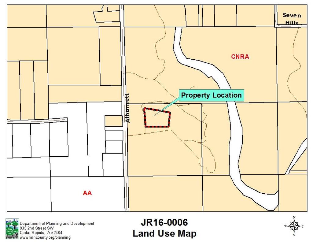
3 CASE # JR EECUTIVE SUMMARY REZONING STAFF CONTACT: STEPHANIE LIENTZ OWNER/APPLICANT INFORMATION OWNER/APPLICANT: Donald & Christine Mesch Linn County Planning & Development MAILING ADDRESS: PROPERTY ADDRESS: 2588 Windy Hill Cir Central City, IA Windy Hill Cir nd St SW Cedar Rapids, IA REQUEST The applicant is proposing to rezone the 2.8 acre subject property from the REC-CNR (Recreation-Critical Natural Resources) overlay district to the CNR (Critical Natural Resources) zoning district. The property is located within the CNRA (Critical Natural Resource Area) on the Rural Land Use Map. The REC (Recreation) designation is used for seasonal cabin and recreation areas. This rezoning was initiated by Linn County Planning & Development staff when it was determined that a single-family dwelling is present on the subject property, which is lived in year-round. The subject property is considered to be a legal lot of record, and contains only 1 single-family dwelling. OUTSTANDING ISSUES AND STANDARDS FOR APPROVAL This proposal meets the standards for approval per Article 4, Section 4 and Article 4, Section 6 of the Linn County Unified Development Code (UDC). The parcel meets the Minimum Levels of Service (MLS) requirements in Appendix A of the UDC. A Land Evaluation and Site Assessment (LESA) analysis is not required per Article 4, Section 6, subsection 1(d) of the UDC, as the proposed rezoning is to a zoning district of equal intensity STAFF RECOMMENDATION Staff recommends approval subject to the conditions of the staff report.
4
5
6
7
8
9 CASE # JR EECUTIVE SUMMARY REZONING STAFF CONTACT: STEPHANIE LIENTZ OWNER/APPLICANT INFORMATION OWNER/APPLICANT: Donald & Christine Mesch Linn County Planning & Development MAILING ADDRESS: PROPERTY ADDRESS: 2588 Windy Hill Cir Central City, IA Windy Hill Cir nd St SW Cedar Rapids, IA REQUEST The applicant is proposing to rezone the 2.8 acre subject property from the REC-CNR (Recreation-Critical Natural Resources) overlay district to the CNR (Critical Natural Resources) zoning district. The property is located within the CNRA (Critical Natural Resource Area) on the Rural Land Use Map. The REC (Recreation) designation is used for seasonal cabin and recreation areas. The current rezoning proposal was initiated by Linn County Planning & Development staff when it was determined that a single-family dwelling is present on the subject property, which is lived in year-round; therefore, it was determined the cabin area designation is inappropriate. The subject property is considered to be a legal lot of record, and contains only 1 single-family dwelling. OUTSTANDING ISSUES AND STANDARDS FOR APPROVAL This proposal meets the standards for approval per Article 4, Section 4 and Article 4, Section 6 of the Linn County Unified Development Code (UDC). A Land Evaluation and Site Assessment (LESA) analysis is not required per Article 4, Section 6, subsection 1(d) of the UDC, as the proposed rezoning is to a zoning district of equal intensity. STAFF RECOMMENDATION Staff recommends approval subject to the conditions of the staff report.
10 Planning & Development Linn County, Iowa phone fax Jean Oxley Public Service Center 935 Second Street Southwest Cedar Rapids, Iowa PZC Approval 11/21/16 STAFF REPORT REZONING JR Planning and Zoning Commission Meeting: NOVEMBER 21, 2016 Board of Supervisors First Consideration: DECEMBER 5, 2016 PROPERTY INFORMATION: 2588 Windy Hill Cir MAP DESIGNATION: CNRA (Critical Natural Resource Area) CURRENT ZONING: REC-CNR (Recreation-Critical Natural Resources) PROPOSED ZONING: CNR (Critical Natural Resources) SURROUNDING LAND USES AND ZONING North Residential, timber, 11 seasonal cabins; REC-CNR South Agricultural; REC-CNR East Residential, timber, 15 seasonal cabins; REC-CNR West Residential, 4 singlefamily dwellings; AG PLAT SIZE: 2.80 acres FORMAL PRE-APPLICATION MEETING: The applicant / surveyor met with staff on October 4, MLS AND LESA REQUIREMENTS: The Minimum Levels of Service (MLS) requirements for properties designated as CNRA (Critical Natural Resource Area) on the Linn County Rural Land Use Map are shown in Appendix A of the UDC. The subject property does not meet all MLS requirements, as it is located over ¼ mile from a hard surface road. However, per Article 4, Section 5(1)(c) of the Unified Development Code (UDC) one purpose for determining this minimum level of service exists is to ensure that there are, adequate roads with sufficient capacity to accommodate traffic anticipated to be generated by the proposed development. In this instance, the subject property contains one (1) single-family
11 Case # JR , Page 3 of 9 dwelling, and there will be no additional development occurring on the site; therefore, staff believes the existing road capacity sufficient. A LESA analysis is not required per Article 4, Section 6, subsection 1(d) of the UDC, as the proposed rezoning is to a zoning district of equal intensity. Article 4, Section 6, (1) states that, A LESA analysis shall be required for all development proposals where a rezoning or subdivision of land is proposed. Exceptions to this shall include: (d) Rezoning to a zoning district of equal or lesser intensity. Linn County Planning and Development staff is proposing to remove the REC overlay zoning district, effectively rezoning the subject property from REC-CNR (Recreation-Critical Natural Resources) to CNR (Critical Natural Resources). Due to the fact that the proposal will result in a zoning classification on the subject property which is of equal intensity to the current zoning district, LESA standards are not required to be met. FINDINGS OF FACT: 1. Donald & Christine Mesch are the owners of the subject property, which is generally described as a Tract of Land beginning at a point 914 feet north and feet east of the corner of the SW NW, then south 87 degrees 43 feet east feet, then north 9 degrees 37 feet east feet, then north 77 degrees 40 feet west feet, then south 2 degrees 16 feet east feet to the Point of Beginning in , and contains approximately 2.80 acres. 2. The property is currently zoned REC-CNR (Recreation-Critical Natural Resources). 3. The property is designated as CNRA (Critical Natural Resource Area) on the Rural Land Use Map. 4. Linn County Planning and Development staff is requesting to rezone the subject property from REC-CNR to CNR (Critical Natural Resources) because it has been determined that a single-family dwelling is present on the property, which is lived in year-round. 5. The property is considered a legal lot of record, and contains one (1) single-family dwelling. 6. The subject property does not meet the Minimum Levels of Service (MLS) requirement for transportation in Appendix A of the UDC for properties designated as CNRA on the Rural Land Use Map. The subject property is located over ¼ mile from a hard surface road; however, there will be no additional development occurring on the site, and Planning and Development staff believes the existing road capacity is sufficient. 7. In accordance with Article 4, Section 6 1(d) of the UDC, the proposal is not subject to meeting Land Evaluation Site Assessment (LESA) requirements due to the fact that the proposal will result in a zoning classification which is of equal intensity to the current zoning district. 8. The Linn County Planning and Zoning Commission recommended approval of this application at their November 21, 2016 meeting by a vote of 5 to 0 (2 absent). CONCLUSIONS OF LAW: Animal feeding operations separation distance requirements. At the time of application, any proposed development that is located near an Iowa Department of Natural Resources (IDNR) permitted animal feeding operation shall be separated by the distance required for the type of structure as provided for in Appendix C of the Unified Development Code.
12 Case # JR , Page 4 of 9 Analysis: The nearest IDNR permitted animal feeding operation lagoon, manure storage facility or confinement building is approximately 2.19 miles from the proposed development area as measured from aerial photography. Conclusion: The requirements of Appendix C of the Unified Development Code appear to be met by the proposed development. Land evaluation and site assessment. All requirements of Article 4, Section 6, of the Unified Development Code shall be met as a condition of approval. Analysis: The rezoning is not subject to the LESA requirements of the UDC based on Article 4, Section 6, 1(d), which states that, A LESA analysis shall be required for all development proposals where a rezoning or subdivision of land is proposed. Exceptions to this shall include: (d) Rezoning to a zoning district of equal or lesser intensity. Due to the fact that the proposal will result in a zoning classification on the subject property which is of equal intensity to the current zoning district, LESA standards are not required to be met. Conclusion: The proposal is in conformance with the UDC. Article 4, Section 5, 5, Additional Standards for Review of the UDC states that any proposed development must be consistent with the Comprehensive Plan, the purposes and intent of the UDC and the supplemental policies, requirements and standards of the UDC, including but not limited to: (a) The proposed development is not detrimental to existing agricultural uses. Analysis: None of the area proposed for rezoning is currently in agricultural production and has not been during the past 5 years. Conclusion: Based on the above analysis, the proposed development is not detrimental to existing agricultural uses. (b) The proposed development will be served by adequate public facilities and services as set forth in a development agreement. Analysis: As previously stated, the subject property is located over ¼ mile from a hard surface road; however, there will be no additional development occurring on the site, and Planning and Development staff believes the existing road capacity is sufficient. MINIMUM LEVEL OF SERVICES FOR CNRA - Residential (Traditional) PUBLIC FACILITY MLS STANDARD CURRENT LEVEL WATER Individual Well Individual Well WASTEWATER On-Site On-Site TRANSPORTATION Class A County Road Within ¼-Mile of a Hard Surface Road 3/4 miles from a hard surface road, Alburnett Road FIRE PROTECTION Within 5-Mile radius of Fire Station Within 4.46 miles of the Troy Mills Fire Station
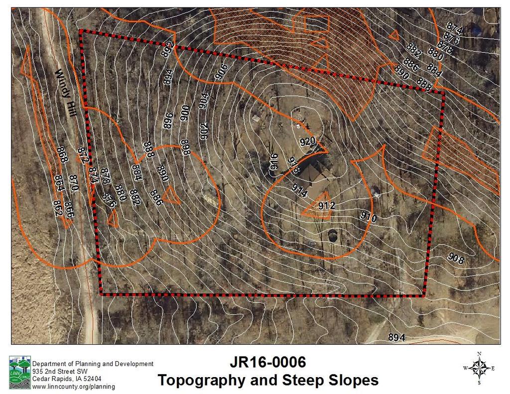
13 Case # JR , Page 5 of 9 Conclusion: The subject property is served by adequate public facilities and services. (c) The proposed development will not degrade significant environmental, ecological or natural resources. Analysis: No threatened and endangered species, unique natural areas, floodplain, or wetlands were identified on the subject property. There are steep slopes present, however, any structures proposed to be constructed on the site shall maintain a minimum setback of fifty (50) feet from steep slope areas, unless an approved mitigation plan is developed. Conclusion: Based on the above analysis, the proposed development will not degrade significant environmental, ecological or natural resources. (d) The proposed development achieves densities and uses in agricultural areas, critical natural resource areas, rural residential development areas and urban service areas as designated in the Comprehensive Plan. Analysis: The 2.8 acre subject property is located in an area designated as Critical Natural Resource Area (CNRA) on the county s land use plan map. Table 3, Land Use Map Designations and Allowable Densities of the 2013 comprehensive plan lists the following recommended densities for Critical Natural Resource Areas: LAND USE MAP DESIGNATION ALLOWABLE DENSITY NOTES CRITICAL NATURAL RESOURCE AREA Infill residential (1 unit per 2 acres except 1 unit per 10 acres within sub-watershed of Cedar River or Wapsipinicon River) New development must be buffered from delineated critical natural resources. The subject property is located within the sub-watershed of the Wapsipinicon River, which has a minimum lot size of 10 acres in areas designated CNRA. Although the subject property has a smaller lot size than the recommended density, it is considered a legal lot of record which has been in existence since at least The subject property is currently zoned REC-CNR, and the rezoning request is intended to remove the REC overlay district, which has standards that apply to cabins and seasonal homes. The subject property contains one (1) single-family dwelling that is lived in year-round. Conclusion: The proposal is in conformance with this provision of the UDC. (e) The proposed development is consistent with the goals, objectives and strategies of the Comprehensive Plan. Table 1 below lists all of the Goals found within each of the seven (7) Plan Elements in the Linn County Comprehensive Plan and determines if the proposal supports, does not support, or is neutral to each individual Goal based on a review of the Objectives and Strategies found in the plan. Any Goals that are of significant consequence to Staff s recommendation are discussed in greater detail below. Analysis: The proposal is supported by a number of Goals and Objectives in the following Comprehensive Plan Elements: Hazard Planning, Resource Protection, Sustainable Development, and Transportation. Conclusion: The proposed plat appears to meet the Goals, Objectives, and Strategies of the Linn County Comprehensive Plan.
14 Case # JR , Page 6 of 9 Table 1. Linn County Comprehensive Plan Goals ELEMENTS GOALS Proposal Supports Alternative and Renewable Energy Economic Development and Employment Opportunities Hazard Planning Livable Communities Resource Protection Goal 1: Encourage and support the development and use of alternative and renewable energy sources. Goal 2: Encourage and support energy efficiency strategies. Goal 3: Identify and mitigate barriers to the development of local alternative and renewable energy resources and increased energy efficiency strategies. Goal 1: Encourage a diverse agricultural economy, including local foods and commodity-based agriculture. Goal 2: Seek opportunities to diversify and expand the local employment base by providing a supportive environment for existing and new businesses, as well as entrepreneurial activities. Goal 3: Support and encourage a well-educated, highly skilled, and diverse workforce prepared for an increasingly competitive global marketplace. Goal 4: Recognize that future economic success in the county depends on implementing sustainable business practices that protect our natural environmental systems. Goal 1: Identify and implement strategies to prevent the occurrence of human-made hazards. Goal 2: Reduce the risk of the loss of life, property, and economic activity as a result of the occurrence of natural and human-made hazards. Goal 3: Increase the capacity of local government and residents to respond to the occurrence of natural and human-made hazards. Goal 4: Increase the capacity of local government and residents to recover from the occurrence of natural and human-made hazards. Goal 1: Protect and enhance the health and safety of all Linn County residents. Goal 2: Maximize resilience through the production and purchase of local and regional products, and the protection of local resources. Goal 3: Enhance connectivity and opportunities for all through improvements in transportation, education, and communication. Goal 4: Plan for demographic trends and changes. Goal 5: Value the county s unique and special places. Goal 1: Support initiatives designed to prevent soil erosion, improve soil quality, and educate the public on the importance of healthy soils in both urban and rural environments. Goal 2: Encourage the long-term viability of agriculture. Goal 3: Strive to maintain high-quality water resources. Goal 4: Address drainage and stormwater management as a regional issue and foster multi-jurisdictional cooperation. Goal 5: Support initiatives designed to protect or improve local air quality. Proposal Does Not Support N/A
15 Case # JR , Page 7 of 9 ELEMENTS GOALS Proposal Supports Sustainable Development Transportation Goal 6: Conserve and enhance natural resources, open space, and wildlife habitat throughout the county. Goal 7: Balance accessibility to local mineral resources with public safety considerations and competing resource protection goals. Goal 1: Maximize the use of existing gray infrastructure and adopt innovative green infrastructure techniques. Goal 2: Proactively address climate change through prevention and adaptation. Goal 3: Incorporate enhanced stormwater management and erosion control practices into county development standards. Goal 4: Encourage green building practices for new construction and major remodels, and consider code amendments that encourage or do not inhibit sustainable development practices. Goal 5: Reduce landfilled waste and support clean, efficient, economical, and environmentally sound management of solid waste. Goal 1: Ensure land use decisions are coordinated with city, county, and regional transportation plans. Goal 2: Encourage alternatives to auto-dependent travel when making transportation, land use, and infrastructure decisions. Goal 3: Consider environmental, cultural, and historic resources in planning future transportation corridors, and in the physical design of transportation infrastructure. Goal 4: Encourage a transportation system that improves the mobility, accessibility, connectivity, and safety for all residents. Goal 5: Promote comprehensive strategies to reduce dependency on nonsustainable fuel sources and increase fuel efficiency. Proposal Does Not Support N/A ALTERNATIVES: The following alternatives may be considered: 1. Recommend approval of the proposal subject to conditions. 2. Recommend denial of the proposal. 3. Refer the proposal back to the applicant for additional review / information. STAFF RECOMMENDATION: Staff recommends Alternative 1, approval, subject to conditions of the staff report. IT IS THE RESPONSIBILITY OF THE APPLICANT TO COMPLETE ALL CONDITIONS, AS OUTLINED IN THIS STAFF REPORT, PRIOR TO FINAL APPROVAL OF THE CASE. IF YOU HAVE QUESTIONS REGARDING A CONDITION, CONTACT THE DEPARTMENT UNDER WHICH THAT CONDITION IS LISTED. THE CONTACTS NAMES AND PHONE NUMBERS ARE LISTED BELOW. ITEMS IN THE COMMENTS SECTION ARE NOT A REQUIREMENT TO BE MET PRIOR TO APPROVAL. THEY ARE INTENDED TO INCREASE YOUR KNOWLEDGE AND AWARENESS OF ISSUES THAT MAY POSSIBLY EIST ON THE PROPERTY.
16 Case # JR , Page 8 of 9 LINN COUNTY ENGINEERING DEPARTMENT STEVE GANNON, COUNTY ENGINEER, Entrance permit required for new entrances and existing unpermitted entrances, Sec.11 and the Unified Development Code, Article 4, Sec. 8B 9(e). One entrance per parcel is allowed. An additional access may be allowed with justification and permit. IOWA DEPARTMENT OF TRANSPORTATION JOEL KEIM, ENGINEERING OPERATIONS TECHNICIAN, Not within the jurisdiction of the Iowa Department of Transportation. LINN COUNTY PUBLIC HEALTH DEPARTMENT SUE ELLEN HOSCH, ENVIRONMENTAL SPECIALIST, No conditions to be met. NATURAL RESOURCES CONSERVATION SERVICE JON GALLAGHER, LINN COUNTY SOIL CONSERVATIONIST JOHN BRUENE, DISTRICT CONSERVATIONIST, x3 1. No conditions to be met. LINN COUNTY CONSERVATION DEPARTMENT DENNIS GOEMAAT, No conditions to be met. Comments: 1. Limit trenching, grading, and construction activity over root zone of trees to be saved. LINN COUNTY EMERGENCY MANAGEMENT MIKE GOLDBERG, No conditions to be met. LINN COUNTY 911 COORDINATOR SHARENE OTTAWAY, No conditions to be met.
17 Case # JR , Page 9 of 9 LINN COUNTY PLANNING AND DEVELOPMENT - ZONING DIVISION STEPHANIE LIENTZ, PLANNER, Prior to close of the Board of Supervisors public hearing, the owner must sign an Acceptance of Conditions form. The Acceptance of Conditions form states that the owner understands and agrees to comply with the agreed upon conditions as negotiated or required by the Board of Supervisors. It is strongly recommended that the owner meet with the Planning and Development staff to review the conditions of the rezoning. 2. The landowner shall sign an Agricultural Land Use Notification form that has been provided by the Zoning Administrator. The landowner shall insure that such notification shall be attached to the deed and shall become a separate entry on the abstract of title for all the property that is subject of the permit or development as per Article 5, Section 1, 8 of the Unified Development Code. Planning & Zoning Commission approval of JR , November 21, 2016 Marquart Landa Bellon Carson Maxwell Dickey Grenis Aye Absent Aye Aye Aye Aye Absent
18

19
20

21

22
23
24

25 Looking south along Windy Hill Circle from existing drive of subject property

26 Looking north along Windy Hill Circle

27 Existing single-family dwelling on the subject property
CASE # JR EXECUTIVE SUMMARY REZONING STAFF CONTACT: STEPHANIE LIENTZ
 CASE # JR16-0002 EXECUTIVE SUMMARY REZONING STAFF CONTACT: STEPHANIE LIENTZ OWNER/APPLICANT INFORMATION OWNER/APPLICANT: Donald & Martha Berner Michael & Sandra Wolrab MAILING ADDRESS: PO BOX 93 Mt Vernon,
CASE # JPS EXECUTIVE SUMMARY RESIDENTIAL PARCEL SPLIT STAFF CONTACT: MIKE TERTINGER
 CASE # JPS17-0019 EXECUTIVE SUMMARY RESIDENTIAL PARCEL SPLIT STAFF CONTACT: MIKE TERTINGER OWNER/APPLICANT INFORMATION OWNER/APPLICANT: MAILING ADDRESS: PROPERTY ADDRESS: Tom & Kim Sindelar 4292 Boy Scouts
CASE # PS EXECUTIVE SUMMARY RESIDENTIAL PARCEL SPLIT STAFF CONTACT: STEPHANIE LIENTZ
 CASE # PS15-0009 EXECUTIVE SUMMARY RESIDENTIAL PARCEL SPLIT STAFF CONTACT: STEPHANIE LIENTZ OWNER/APPLICANT INFORMATION OWNER/APPLICANT: James L & Esther M Benesh Darek Benesh MAILING ADDRESS: PROPERTY
Prepared by and to be returned to Linn County Planning & Development nd Street S.W., Cedar Rapids, Iowa (319)
") Prepared by and to be returned to Linn County Planning & Development 935 2 nd Street S.W., Cedar Rapids, Iowa 52404-2161 (319) 892-5130 LINN COUNTY, IOWA ZONING BOARD OF ADJUSTMENT IN THE MATTER OF THE
Prepared by and to be returned to Linn County Planning & Development 935 2 nd Street S.W., Cedar Rapids, Iowa 52404-2161 (319) 892-5130 LINN COUNTY, IOWA ZONING BOARD OF ADJUSTMENT IN THE MATTER OF THE
Prepared by and to be returned to Linn County Planning & Development nd Street S.W., Cedar Rapids, Iowa (319)
") Prepared by and to be returned to Linn County Planning & Development 935 2 nd Street S.W., Cedar Rapids, Iowa 52404-2161 (319) 892-5130 LINN COUNTY, IOWA ZONING BOARD OF ADJUSTMENT In the matter of the
Prepared by and to be returned to Linn County Planning & Development 935 2 nd Street S.W., Cedar Rapids, Iowa 52404-2161 (319) 892-5130 LINN COUNTY, IOWA ZONING BOARD OF ADJUSTMENT In the matter of the
LINN COUNTY BOARD OF SUPERVISORS CEDAR RAPIDS, LINN COUNTY, IOWA WEDNESDAY, APRIL 29, :00 A.M.
 LINN COUNTY BOARD OF SUPERVISORS CEDAR RAPIDS, LINN COUNTY, IOWA WEDNESDAY, APRIL 29, 2015 10:00 A.M. The Board met in session at the Linn County Jean Oxley Public Service Center. Present: Vice Chairperson
Guide to Preliminary Plans
 Guide to Preliminary Plans Introduction The Douglas County is committed to providing open, transparent application processes to the public. This Guide is provided to assist anyone interested in the procedures
LINN COUNTY BOARD OF SUPERVISORS CEDAR RAPIDS, LINN COUNTY, IOWA WEDNESDAY, JANUARY 21, :30 A.M.
 LINN COUNTY BOARD OF SUPERVISORS CEDAR RAPIDS, LINN COUNTY, IOWA WEDNESDAY, JANUARY 21, 2015 8:30 A.M. The Board met in session at the Linn County Jean Oxley Public Service Center. Present: Chairperson
STAFF REPORT. Permit Number: Porter. Kitsap County Board of Commissioners; Kitsap County Planning Commission
 STAFF REPORT Permit Number: 15 00461 Porter DATE: November 9, 2015 TO: FROM: Kitsap County Board of Commissioners; Kitsap County Planning Commission Katrina Knutson, AICP, Senior Planner, DCD and Jeff
LINN COUNTY PLANNING & ZONING COMMISSION. MINUTES Monday, September 17, 2018
 LINN COUNTY PLANNING & ZONING COMMISSION MINUTES Monday, The Linn County Planning and Zoning Commission meeting was called to order at 6:30 p.m. by Chair, Christine. The meeting was held in the Jean Oxley
CHAPTER Committee Substitute for Committee Substitute for Senate Bill No. 2188
 CHAPTER 2004-372 Committee Substitute for Committee Substitute for Senate Bill No. 2188 An act relating to land development; amending s. 197.502, F.S.; providing for the issuance of an escheatment tax
Marion County Board of County Commissioners
 Marion County Board of County Commissioners Date: 6/4/217 P&Z: 9/25/217 BCC Transmittal: 1/17/217 BCC Adopt: TBD Amendment No: 217-L6 Type of Application Large-Scale Comp Plan Amendment Request: Change
CONDITIONAL USE PERMIT Application Packet
 CONDITIONAL USE PERMIT Application Packet Community Development Department 1020 East Pioneer Road, Draper, UT 84020 (801) 576-6539 Fax (801) 576-6526 Dear Applicant, This application packet has been developed
Larimer County Planning Dept. Procedural Guide for 1041 PERMITS
 - Larimer County Planning Dept. Procedural Guide for 1041 PERMITS PLEASE NOTE: A PRE-APPLICATION CONFERENCE IS REQUIRED PRIOR TO SUBMITTING THIS APPLICATION. PURPOSE: State Statutes allow local governments
Planning Justification Report
 Planning Justification Report, Township of Puslinch FARHI HOLDINGS CORPORATION Updated January 27, 2017 Zelinka Priamo Ltd. Page i TABLE OF CONTENTS Page No. 1.0 1.1 1.2 1.3 2.0 2.1 2.2 2.3 2.4 2.5 3.0
MEETING AGENDA WEDNESDAY, MAY 9, :00 A.M. FORMAL BOARD ROOM JEAN OXLEY PUBLIC SERVICE CENTER 935 SECOND STREET SW, CEDAR RAPIDS, IOWA
 James Houser District 1 Stacey Walker District 2 Ben Rogers District 3 Brent Oleson District 4 John Harris District 5 935 Second Street Southwest Cedar Rapids, Iowa 52404-2100 MEETING AGENDA WEDNESDAY,
EDGERTON CITY HALL PLANNING COMMISSION MEETING REGULAR SESSION March 12, 2019
 EDGERTON CITY HALL PLANNING COMMISSION MEETING REGULAR SESSION The met in regular session with Chair John Daley calling the meeting to order at 7:00 p.m. All present participated in the Pledge of Allegiance.
Resolution allowing Regis Middle School use of the Linn County Courthouse for the purpose of hosting a Mock Trial on Saturday, November 3, 2018.
 BOARD OF SUPERVISORS District 1 James Houser District 2 Stacey Walker District 3 Ben Rogers District 4 Brent Oleson District 5 John Harris Call to Order LINN COUNTY BOARD OF SUPERVISORS MEETING AGENDA
PLANNING REPORT. Prepared for: John Spaleta 159 Delatre Street Woodstock Ontario N4S 6C2
 PLANNING REPORT County Official Plan Amendment and Zoning By-law Amendment to Permit a Seasonal Dwelling on an Existing Lot of Record with Access onto a Seasonally Maintained Road Parts of Lot 29, Concession
SECTION 16. "PUD" PLANNED UNIT DEVELOPMENT OVERLAY DISTRICT
 SECTION 6. "PUD" PLANNED UNIT DEVELOPMENT OVERLAY DISTRICT Subsection. Purpose. This district is established to achieve the coordinated integration of land parcels and large commercial and retail establishments
LINN COUNTY BOARD OF ADJUSTMENT. Jean Oxley Public Service Center nd Street SW, Cedar Rapids, Iowa. MINUTES Wednesday, March 28, 2018
 LINN COUNTY BOARD OF ADJUSTMENT Jean Oxley Public Service Center 935 2 nd Street SW, Cedar Rapids, Iowa MINUTES Wednesday, I. QUORUM DETERMINE D: The Linn County Board of Adjustment meeting was called
SANjOSE CAPITAL OF SILICON VALLEY
 COUNCIL AGENDA: 06/14/16 ITEM: 11.1(a) CITY OF ffr -3 SANjOSE CAPITAL OF SILICON VALLEY CITY COUNCIL STAFF REPORT File No. C16-015 Applicant: Owens Mortgage Investment Fund Location 455 Piercy Road Existing
If projects are received at the counter to be submitted without prior draft review, the project will be deferred to the next meeting.
 5400 Butternut Drive East Syracuse, NY13057-8509 Phone: 315.446.3910 x3 Fax: 315.449.0620 Edward M.Michalenko, PhD. Supervisor Planning & Zoning Samuel C. Gordon, MLA, Director Welcome to the Town of DeWitt
Amendment to the Zoning and Subdivision Ordinances; Consider Repeal Cluster Development Standards
 2 Board of Supervisors Meg Bohmke, Chairman Gary F. Snellings, Vice Chairman Jack R. Cavalier Thomas C. Coen L. Mark Dudenhefer Wendy E. Maurer Cindy C. Shelton February 28, 2018 Thomas C. Foley County
Guide to Combined Preliminary and Final Plats
 Guide to Combined Preliminary and Final Plats Introduction The Douglas County is committed to providing open, transparent application processes to the public. This Guide is provided to assist anyone interested
Spirit Lake North, LLC
 BONNER COUNTY PLANNING DEPARTMENT PLANNING AND ZONING COMMISSION STAFF REPORT FOR March 1, 2018 Project Name: Amendment & Zone Change: Spirit Lake North, LLC File Number,Type: AM 162-18/ZC365-18 Request:
Concept Plan Project Narrative For 852 River Ranch Court
 Concept Plan Project Narrative For 852 River Ranch Court Date: January 5, 2016 Prepared by: Robert W. Jones II, P.E. Vortex Engineering, Inc. 2394 Patterson Rd., Ste 201 Grand Junction, CO 81505 970-245-9051
Crystal Falls Township Master Plan
 Crystal Falls Township Master Plan January 2003 Updated 2010 Township Officials Master Plan Update, 2010 Crystal Falls Township Iron County, Michigan Planning Commission Curtis Stebic, Chair Beverly Camp,
Rapid City Planning Commission
 Rapid City Planning Commission Initial Planned Development Overlay Project Report March 9, 2017 Item #15 Applicant Request(s) Case # 17PD007 Initial Planned Development Overlay to allow a residential development
Chapter 210 CONDITIONAL USES
 Chapter 210 CONDITIONAL USES 210.01 Purpose 210.02 Authorization 210.03 Process Type 210.04 Determination of Major or Minor Conditional Use Review 210.05 Approval Criteria 210.06 Conditions of Approval
Guide to Minor Developments
 Guide to Minor Developments Introduction The Douglas County (DCD) is committed to providing open, transparent application processes to the public. This Guide is provided to assist anyone interested in
STAFF REPORT UNIFIED DEVELOPMENT CODE (UDC) AMENDMENTS
 AMENDMENTS") STAFF REPORT UNIFIED DEVELOPMENT CODE (UDC) AMENDMENTS Planning and Zoning Commission Meeting: JULY 20, 2015 Board of Supervisors First Consideration: AUGUST 3, 2015 CASE: A15-0002 PETITIONER: Planning
STAFF REPORT UNIFIED DEVELOPMENT CODE (UDC) AMENDMENTS Planning and Zoning Commission Meeting: JULY 20, 2015 Board of Supervisors First Consideration: AUGUST 3, 2015 CASE: A15-0002 PETITIONER: Planning
MIDWAY CITY Municipal Code
 MIDWAY CITY Municipal Code TITLE 9 ANNEXATION CHAPTER 9.01 PURPOSE CHAPTER 9.02 GENERAL REQUIREMENTS CHAPTER 9.03 PROPERTY OWNER INITIATION OF ANNEXATION CHAPTER 9.04 PROCEDURES FOR CONSIDERATION OF PETITION
Town of Norwich, Vermont SUBDIVISION REGULATIONS
 Town of Norwich, Vermont SUBDIVISION REGULATIONS Adopted: August 6, 2002 Amended: February 8, 2006 Prepared by Norwich Planning Commission with the assistance of: Burnt Rock Inc. A ssociates in Community
STAFF REPORT. Permit Number: Garland. Kitsap County Board of Commissioners; Kitsap County Planning Commission
 STAFF REPORT Permit Number: 15 00686 Garland DATE: February 25, 2016 TO: FROM: Kitsap County Board of Commissioners; Kitsap County Planning Commission Katrina Knutson, AICP, Senior Planner, DCD and Jeff
BY BOARD OF COUNTY COMMISSIONERS AN ACT TO BE ENTITLED
 BY BOARD OF COUNTY COMMISSIONERS ORDINANCE NO. AN ACT TO BE ENTITLED AN ORDINANCE AMENDING THE PASCO COUNTY LAND DEVELOPMENT CODE, ARTICLE 700, BY REPEALING EXISTING SECTION 702, ENVIRONMENTALLY SENSITIVE
APPLICATION. Telephone Fax Address. Telephone Fax Address FOR MARTIN COUNTY USE ONLY
 APPLICATION PRESERVE AREA MANAGEMENT PLAN/ ABBREVIATED PRESERVE AREA MANAGEMENT PLAN Growth Management Department Environmental Division PART 1: Applicant Information A. Land Owner(s) Name Title and Company
A. Preserve natural resources as identified in the Comprehensive Plan.
 1370.08 Conservation Residential Overlay District. Subd. 1 Findings. The City finds that the lands and resources within the Conservation Residential Overlay District are a unique and valuable resource
ARTICLE XI - CONSERVATION SUBDIVISIONS
 ARTICLE XI - CONSERVATION SUBDIVISIONS Section 1101: Purpose and Intent. This Article is intended to provide for residential subdivisions that are designed based first and foremost on the preservation
TOWN OF ORO VALLEY PLANNING & ZONING COMMISSION MEETING DATE: December 6, 2011
 PLANNING & ZONING COMMISSION MEETING DATE: December 6, 2011 TO: FROM: SUBJECT: PLANNING & ZONING COMMISSION Matt Michels, Senior Planner mmichels@orovalleyaz.gov; tel. 229-4822 Public Hearing: Rancho de
BEFORE THE HEARING EXAMINER FOR THURSTON COUNTY
 COUNTY COMMISSIONERS Cathy Wolfe District One Diane Oberquell District Two Robert N. Macleod District Three HEARING EXAMINER BEFORE THE HEARING EXAMINER FOR THURSTON COUNTY In the Matter of the Application
Packet Contents: Page #
 CLEAR CREEK COUNTY PLANNING DEPARTMENT REQUIREMENTS FOR COMMERCIAL AND MULTI-FAMILY DEVELOPMENTS Prior to submitting a building permit application, the Planning staff will review the site plan and construction
Kitsap County Department of Community Development
 Kitsap County Department of Community Development Staff Report and Recommendation Annual Comprehensive Plan Amendment Process for 2018 George s Corner LAMIRD Boundary Adjustment Report Date 7/16/2018 Hearing
ALREADY SUBMITTED FOR HIGHLANDS COUNCIL PRE
 Highlands Preservation Area Approval Application Checklist Items Block 15901 Lot 1, West Milford See Highlands Council Review at: http://www.highlands.state.nj.us/njhighlands/projectreview/ **For advisory
8Land Use. The Land Use Plan consists of the following elements:
 8Land Use 1. Introduction The Land Use Plan consists of the following elements: 1. Introduction 2. Existing Conditions 3. Opportunities for Redevelopment 4. Land Use Projections 5. Future Land Use Policies
FINDINGS OF FACT. Page 1 of 8
 FINDINGS OF FACT The City/County Planning staff has prepared the Findings of Fact for the Emerald View Park Subdivision, Amended Lot 1A, Block 3. These findings are based on the preliminary plat application
RPP Subcommittee Members Present: Subcommittee Chair Elizabeth Taylor, Jacqueline Etsten, Kevin Grunwald, Charles McCaffrey
 Cape Cod Commission Regional Policy Plan Subcommittee Meeting Cape Cod Commission Large Conference Room 3225 Main Street, Barnstable, MA 02630 November 29, 2018 The meeting of the Cape Cod Commission s
Guide to Replats. Step 1. Step 2. Step 3. Step 4. Step 5. Step 6. Step 7. Step 8. Step 9. Step 10
 Guide to Replats Introduction Douglas County is committed to providing open, transparent application processes to the public. This Guide is provided to assist anyone interested in the procedures and expectations
Chapter 100 Planned Unit Development in Corvallis Urban Fringe
 100.100 Scope and Purpose. Chapter 100 Planned Unit Development in Corvallis Urban Fringe (1) All applications for land divisions in the Urban Residential (UR) and Flood Plain Agriculture (FPA) zones within
PLANNING AND ZONING COMMISSION ZONE CHANGE
 PLANNING AND ZONING COMMISSION ZONE CHANGE DOÑA ANA COUNTY COMMUNITY DEVELOPMENT DEPARTMENT Doña Ana County Government Center 845 N. Motel Blvd. Las Cruces, New Mexico 88007 Telephone: (575) 647-7350 MEETING
LINN COUNTY BOARD OF SUPERVISORS CEDAR RAPIDS, LINN COUNTY, IOWA WEDNESDAY, APRIL 1, :00 A.M.
 LINN COUNTY BOARD OF SUPERVISORS CEDAR RAPIDS, LINN COUNTY, IOWA WEDNESDAY, APRIL 1, 2015 10:00 A.M. The Board met in session at the Linn County Jean Oxley Public Service Center. Present: Chairperson Langston,
Rapid City Planning Commission
 Rapid City Planning Commission Initial Planned Development Overlay Project Report June 7, 2018 Item #5 Applicant Request(s) Case # 18PD019 Initial Planned Development Overlay to allow an apartment complex
Planning Department Oconee County, Georgia
 Planning Department Oconee County, Georgia STAFF REPORT REZONE CASE #: 6985 DATE: October 31, 2016 STAFF REPORT BY: Andrew C. Stern, Planner APPLICANT NAME: Williams & Associates, Land Planners PC PROPERTY
Township of Tay Official Plan
 Township of Tay Official Plan Draft for Consultation (v.3) March 2016 Contents 1. INTRODUCTION... 1 1.1 Content, Title and Scope... 1 1.2 Basis and Purpose of this Plan... 1 1.3 Plan Structure... 2 2.
FUTURE LAND USE. City of St. Augustine Comprehensive Plan EAR-Based Amendments
 FUTURE LAND USE City of St. Augustine Comprehensive Plan EAR-Based Amendments Future Land Use Element FLU Goal To create an environment within the City and adjacent areas in which its residents have the
APPLICATION FOR SUBDIVISION APPROVAL OF A SKETCH PLAN with checklist
 Prior to filing any application for SUBDIVISION approval, the applicant shall request in writing that the zoning administrator schedule a pre-submission conference. APPLICATION TO THE PLANNING BOARD TOWN
REZONING APPLICATION INSTRUCTIONS
 REZONING APPLICATION INSTRUCTIONS All required information, as stated on the Rezoning Application Checklist, must be included to qualify as a complete application. Upon receipt, staff will review the application
Municipality of Brockton Planning Report. Application: Minor Variance Application. Members of the Committee of Adjustment, Municipality of Brockton
 Municipality of Brockton Planning Report Application: Minor Variance Application File No: A-14-18.34 Date: May 14, 2018 To: From: Subject: Members of the Committee of Adjustment, Municipality of Brockton
FOR OFFICE USE ONLY Date Submitted Received By Fees Paid $ Receipt No. Received By Application No. Application Complete Final Action Date
 COMMERCIAL, INDUSTRIAL, & MANUFACTURING SITE PLAN (CIM) APPLICATION Mariposa County Planning Department 5100 Bullion Street, P.O. Box 2039 Mariposa, CA 95338 Telephone (209) 966-5151 FAX (209) 742-5024
GOVERNMENT CODE SECTION GOVERNMENT CODE SECTION 65302
 GOVERNMENT CODE SECTION 65300 65300. Each planning agency shall prepare and the legislative body of each county and city shall adopt a comprehensive, long-term general plan for the physical development
EVALUATION AND APPRAISAL REPORT OF THE CITY OF FELLSMERE COMPREHENSIVE PLAN APPENDIX D HOUSING ELEMENT
 OBJECTIVE H-A-1: ALLOW AFFORDABLE HOUSING AND ADEQUATE SITES FOR VERY LOW, LOW, AND MODERATE INCOME HOUSING. The City projects the total need for very low, low, and moderate income-housing units for the
CITY OF FORT COLLINS NATURAL AREAS AND CONSERVED LANDS EASEMENT POLICY
 CITY OF FORT COLLINS NATURAL AREAS AND CONSERVED LANDS EASEMENT POLICY Adopted January 3, 2012 PURPOSE: The purpose of the policy statement is to clarify the policies and procedures of the City of Fort
ORDINANCE NO. _4.06 AN ORDINANCE TO ESTABLISH BUILDING SITE REGULATIONS SECTION A PURPOSE AND INTENT
 ORDINANCE NO. _4.06 AN ORDINANCE TO ESTABLISH BUILDING SITE REGULATIONS SECTION A PURPOSE AND INTENT This Ordinance provides minimum regulations, provisions and requirements for safe, aesthetically pleasing
APPENDIX B COMPLIANCE WITH THE GOVERNMENT CODE
 APPENDIX B COMPLIANCE WITH THE GOVERNMENT CODE A. GENERAL PLAN AMENDMENT PROCEDURE In general, local governments may not amend any of the mandatory elements of the General Plan (e.g. Land Use, Open Space,
PLANNING DIVISION COMMUNITY & ECONOMIC DEVELOPMENT. To: Salt Lake City Planning Commission. PLNPCM John Glenn Road Zoning Map Amendments
 Staff Report PLANNING DIVISION COMMUNITY & ECONOMIC DEVELOPMENT To: Salt Lake City Planning Commission From: John Anderson, 801-535-7214, john.anderson@slcgov.com Date: March 22, 2017 Re: PLNPCM2017-00063
Reading Plats and the Complexities of Antiquated Subdivisions Presented by: David W. Depew, PhD, AICP, LEED AP Morris-Depew Associates, Inc.
 Presented by: David W. Depew, PhD, AICP, LEED AP Morris-Depew Associates, Inc. Introduction Plat is a term for a survey of a piece of land to identify boundaries, easements, flood zones, roadway, and access
TREASURE COAST REGIONAL PLANNING COUNCIL M E M O R A N D U M
 TREASURE COAST REGIONAL PLANNING COUNCIL M E M O R A N D U M To: Council Members AGENDA ITEM 5F From: Date: Subject: Staff July 16, 2010 Council Meeting Local Government Comprehensive Plan Review Draft
SECTION 4: PRELIMINARY PLAT
 SECTION 4: PRELIMINARY PLAT After the completion of the sketch plan process, if submitted, the owner or developer shall file with the City an application for preliminary plat. The preliminary plat stage
Prepared by and to be returned to Linn County Planning & Development nd Street S.W., Cedar Rapids, Iowa (319)
") Prepared by and to be returned to Linn County Planning & Development 935 2 nd Street S.W., Cedar Rapids, Iowa 52404-2161 (319) 892-5130 LINN COUNTY, IOWA ZONING BOARD OF ADJUSTMENT IN THE MATTER OF THE
Prepared by and to be returned to Linn County Planning & Development 935 2 nd Street S.W., Cedar Rapids, Iowa 52404-2161 (319) 892-5130 LINN COUNTY, IOWA ZONING BOARD OF ADJUSTMENT IN THE MATTER OF THE
Financial Impact Statement There are no immediate financial impacts associated with the adoption of this report.
 STAFF REPORT Planning and Development Department Subject: Application by RYC Property to rezone a portion of lands on John Murray Dr. and Megan Lynn Dr. from R2 to R3 and to enter into a Development Agreement
CITY OF FERNDALE HEARING EXAMINER
 CITY OF FERNDALE HEARING EXAMINER RE: Planned Unit Development ) 16001-PUD Preliminary Plat ) 16018-SE Plat Variance ) 16002-VAR Application by ) ) MD General, L.L.C. ) FINDINGS OF FACT, Malloy Heights
Plans shall be drawn at a readable scale, signed, and sealed by a Florida Registered Engineer. The application package shall include:
 CHAPTER 400. SECTION 403. PERMIT TYPES AND APPLICATIONS SITE DEVELOPMENT 403.3. Preliminary Site Plans (PSP) A. Intent and Purpose PSPs are used to identify existing site conditions and demonstrate general
CHAPTER 3 PRELIMINARY PLAT
 10-3-1 10-3-3 SECTION: CHAPTER 3 PRELIMINARY PLAT 10-3-1: Consultation 10-3-2: Filing 10-3-3: Requirements 10-3-4: Approval 10-3-5: Time Limitation 10-3-6: Grading Limitation 10-3-1: CONSULTATION: Each
Agenda Item No. October 14, Honorable Mayor and City Council Attention: David J. Van Kirk, City Manager
 Agenda Item No. October 14, 2008 TO: FROM: SUBJECT: Honorable Mayor and City Council Attention: David J. Van Kirk, City Manager Scott D. Sexton, Community Development Director ORDINANCE OF THE CITY COUNCIL
ZONING AMENDMENT & SUBDIVISION STAFF REPORT Date: July 3, 2014
 ZONING AMENDMENT & SUBDIVISION STAFF REPORT Date: July 3, 2014 APPLICANT NAME SUBDIVISION NAME LOCATION Georgia Crown Distributing Subdivision Georgia Crown Distributing Subdivision Southwest corner of
GWINNETT COUNTY CSO CONSERVATION SUBDIVISION OVERLAY DISTRICT REQUIREMENTS
 GWINNETT COUNTY CSO CONSERVATION SUBDIVISION OVERLAY DISTRICT REQUIREMENTS Section 1316. CSO Conservation Subdivision Overlay District. 1. Purposes. The purposes of this overlay district are as follows:
HOUSING ELEMENT GOALS, OBJECTIVES, AND POLICIES
 HOUSING ELEMENT GOALS, OBJECTIVES, AND POLICIES GOAL 1: To promote the preservation and development of high-quality, balanced, and diverse housing options for persons of all income levels throughout the
CLAY TOWNSHIP PLANNING COMMISSION MEETING MINUTES September 28, 2015
 CLAY TOWNSHIP PLANNING COMMISSION MEETING MINUTES September 28, 2015 Members present were: Bruce Leisey, Clair Beyer and Annie Reinhart. Jon Price arrived at 7:10 and Adrian Kapp were absent. Also present
Letter of Intent May 2017 (Revised November 2017)
") THE BEACH AT WOODMOOR LETTER OF INTENT MAY 2017 (REVISED NOVEMBER 2017) OWNER/APPLICANT: CONSULTANT: Lake Woodmoor Holdings LLC N.E.S. Inc. 1755 Telstar Drive, Suite 211 619 North Cascade Avenue Colorado
THE BEACH AT WOODMOOR LETTER OF INTENT MAY 2017 (REVISED NOVEMBER 2017) OWNER/APPLICANT: CONSULTANT: Lake Woodmoor Holdings LLC N.E.S. Inc. 1755 Telstar Drive, Suite 211 619 North Cascade Avenue Colorado
SITE DEVELOPMENT PLAN REQUIREMENTS CHECKLIST
 SITE DEVELOPMENT PLAN REQUIREMENTS CHECKLIST Completed DRC Application for Review Required for Application Process DRC Processing Fee 1 Commercial $2,500.00 Fire Department Review Fee 150.00 Total $2,650.00
ARTICLE FIVE FINAL DRAFT
 ARTICLE FIVE 021218 FINAL DRAFT Sec. 503.6 Open Space Preservation Option Open Space Preservation Option Open Space Preservation developments may be approved in the AR, R-1, R-2 and R-3 zoning districts,
TOWN OF BRISTOL. Ontario County, New York APPLICATION FOR LOT LINE ADJUSTMENT
 TOWN OF BRISTOL Ontario County, New York APPLICATION FOR LOT LINE ADJUSTMENT Lot Line Adjustment: The adjusting of common property line(s) or boundaries between adjacent lots, tracts, or parcels for the
MEMORANDUM. Critical Areas Ordinance Density Requirements
 COUNTY COMMISSIONERS Creating Solutions for Our Future Cathy Wolfe District One Sandra Romero District Two Karen Valenzuela District Three PLANNING DEPARTMENT Scott Clark Director MEMORANDUM TO: FROM:
North Qu Appelle No. 187 Bylaw Basic Planning Statement - Table of Contents
 - Table of Contents Section1 Introduction 2 Section 2 - The Rural Municipality of North Qu Appelle No. 187 3 Section 3 Municipal Goals.... 3 Section 4 Agriculture and Natural Resources.. 4 Section 5 Residential
OFFICIAL COMMUNITY PLAN Rural Municipality of Willner No. 253
 OFFICIAL COMMUNITY PLAN Rural Municipality of Willner No. 253 Official Community Plan prepared by: Autumn Dawson MCIP, PPS S.A.R.M Planning Services Page 2 of 28 RURAL MUNICIPALITY OF WILLNER NO. 253 BYLAW
Open Space Model Ordinance
 Open Space Model Ordinance Section I. Background Open space development has numerous environmental and community benefits, including: 1) Reduces the impervious cover in a development. Impervious cover
COMMUNITY PRESERVATION ACT Town of Hatfield OPEN SPACE PROJECT GUIDELINES
 COMMUNITY PRESERVATION ACT Town of Hatfield OPEN SPACE PROJECT GUIDELINES CPA Open Space Projects: The Act requires that a participating community shall spend, or set aside for later spending, not less
Project File #: SF Project Name: Jackson Ranch Filing No. 4 Parcel Nos.: , and
 COMMISSIONERS: DARRYL GLENN (PRESIDENT) MARK WALLER (PRESIDENT PRO TEMPORE) STAN VANDERWERF LONGINOS GONZALEZ PEGGY LITTLETON PLANNING AND COMMUNITY DEVELOPMENT DEPARTMENT CRAIG DOSSEY, EXECUTIVE DIRECTOR
PRELIMINARY SUBDIVISION PLAN APPLICATION INSTRUCTIONS
 City of Chesapeake Department of Planning Post Office Box 15225 Chesapeake, Virginia 23328-5225 (757) 382-6176 FAX (757) 382-6406 PRELIMINARY SUBDIVISION PLAN APPLICATION INSTRUCTIONS PURPOSE A preliminary
PROJECT SCORING GUIDANCE. Introduction: National Proiect Selection:
 FOREST LEGACY PROGRAM PROJECT SCORING GUIDANCE Introduction: This document provides guidance to the National Review Panel on how to score individual Forest Legacy Program (FLP) projects, including additional
AGENDA Wednesday, March 2, :00 A.M. Formal Board Room Jean Oxley Public Service Center 935 Second Street SW, Cedar Rapids, Iowa
 James Houser District 1 Linda Langston District 2 Ben Rogers District 3 Brent Oleson District 4 John Harris District 5 935 Second Street Southwest Cedar Rapids, Iowa 52404-2100 AGENDA Wednesday, March
Town of Shelburne, Vermont
 Town of Shelburne, Vermont CHARTERED 1763 P.O. BOX 88 5420 SHELBURNE ROAD SHELBURNE, VT 05482 www.shelburnevt.org 802-985-5118 * * Also available in alternate formats in accordance with the Americans With
O-I (Office-Institutional) and AG-1(Agricultural)
 and AG-1(Agricultural)") PROPERTY INFORMATION ADDRESS 3503 and 3505 Bethany Bend DISTRICT, LAND LOTS 2/1 973 and 974 OVERLAY DISTRICT State Route 9 PETITION NUMBERS EXISTING ZONING O-I (Office-Institutional) and AG-1(Agricultural)
PROPERTY INFORMATION ADDRESS 3503 and 3505 Bethany Bend DISTRICT, LAND LOTS 2/1 973 and 974 OVERLAY DISTRICT State Route 9 PETITION NUMBERS EXISTING ZONING O-I (Office-Institutional) and AG-1(Agricultural)
Rapid City Planning Commission Rezoning Project Report
 Rapid City Planning Commission Rezoning Project Report August 4, 2016 Case # 16RZ027 Associated Case #16RZ028 Associated Case #16RZ029 Item 2 Applicant Request(s) A request to rezone property from High
Strategic Growth Council: Identifying Infill Barriers
 Streamlining Infill in the CEQA Guidelines (SB 226) Strategic Growth Council: Identifying Infill Barriers Looking within state agencies to reduce conflicts and promote successful programs Working with
Title 6 - Local Government Provisions Applicable to Special Purpose Districts and Other Political Subdivisions
 Title 6 - Local Government Provisions Applicable to Special Purpose Districts and Other Political Subdivisions CHAPTER 29. SOUTH CAROLINA LOCAL GOVERNMENT COMPREHENSIVE PLANNING ENABLING ACT OF 1994 1994
ZONING AMENDMENT & SUBDIVISION STAFF REPORT Date: March 7, 2013
 # 4 & 5 SUB2012-00141 & ZON2012-03157 HOLDOVER ZONING AMENDMENT & SUBDIVISION STAFF REPORT Date: March 7, 2013 APPLICANT NAME SUBDIVISION NAME LOCATION Garrard Development Services, LLC Michigan & Bay
Required and optional elements of comprehensive plan; studies and surveys.
 163.3177 Required and optional elements of comprehensive plan; studies and surveys. (1) The comprehensive plan shall provide the consist of materials in such descriptive form, written or graphic, as may
NOTICE OF STATE MANDATED FEE! Approx. = $900 per Acre to Rezone A-1 Land
 NOTICE OF STATE MANDATED FEE! Approx. = $900 per Acre to Rezone A-1 Land STATE OF WISCONSIN MANDATED FARMLAND PRESERVATION ZONE DISTRICT REZONE CONVERSION FEE Beginning January 1, 2010, the State of Wisconsin
LAND USE AND ZONING OVERVIEW
 OVERVIEW OF PLANNING POLICIES LAND USE AND ZONING OVERVIEW The Minneapolis Plan for Sustainable Growth and Other Adopted Plans Community Planning and Economic Development Development Services Division