STAFF REPORT. Permit Number: Garland. Kitsap County Board of Commissioners; Kitsap County Planning Commission
|
|
|
- Marjory Patrick
- 5 years ago
- Views:
Transcription

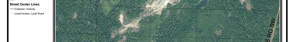
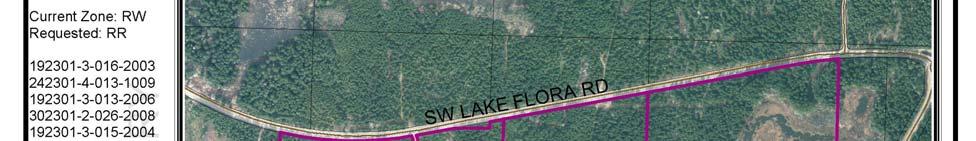
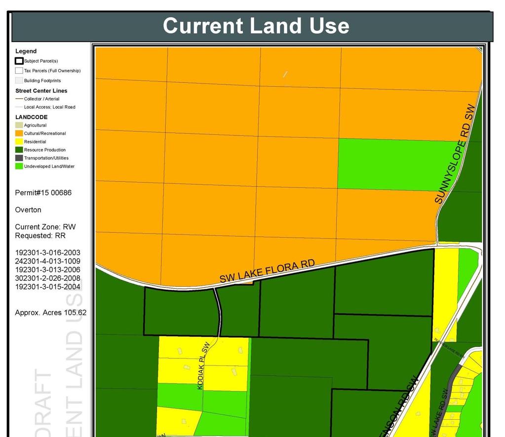
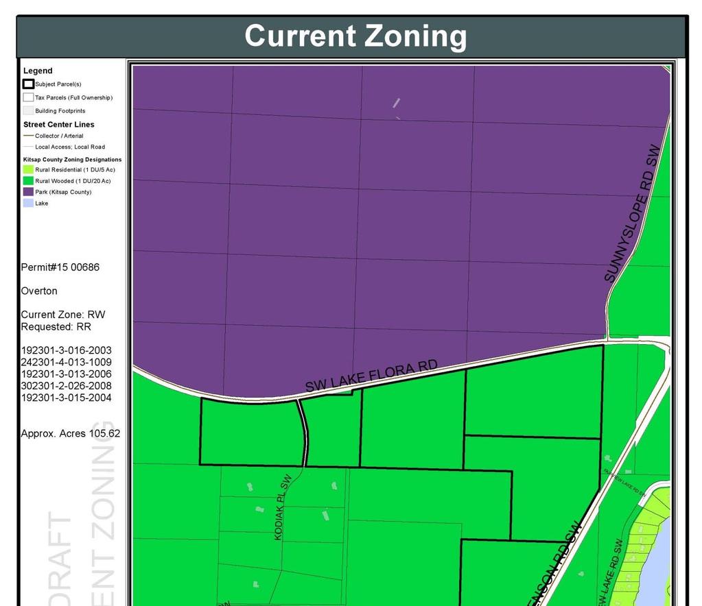
1 STAFF REPORT Permit Number: Garland DATE: February 25, 2016 TO: FROM: Kitsap County Board of Commissioners; Kitsap County Planning Commission Katrina Knutson, AICP, Senior Planner, DCD and Jeff Arango, AICP, Senior Associate, BERK Consulting RE: Garland Reclassification Request APPLICATION INFORMATION 1. Applicant Name: Mel Garland, Apex Engineering, PLLC (Applicant and Authorized Agent); North Mason, L.P., North Bay Properties, L.P., Coulter Creek, L.P. (Owners) 2. Parcel Number: , , , , Address or area location information: Access to SW Lake Flora Road or JM Dickenson Road SW; see Attachment 1 4. Current Land Use: Undeveloped land; see Attachment Current Comprehensive Plan Designation: Rural Wooded (RW) 6. Proposed Comprehensive Plan Designation: Rural Protection (RP) (Applicant revised request from RR to RP in February 2016). 7. Current Zoning: Rural Wooded (RW); see Attachment Proposed Zoning: Rural Protection (RP); (Applicant revised request from RR to RP in February 2016). 9. Lot Area / Size: acres 10. Comprehensive Plan Alternative: Included as part of the 2016 Comprehensive Plan Update Supplemental Environmental Impact Statement (SEIS) Alternative Preferred Alternative: The request is included in the Preferred Alternative as Rural Protection. 1
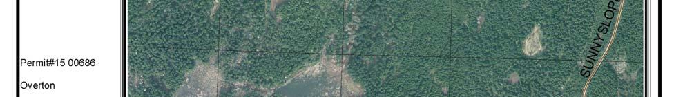
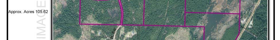
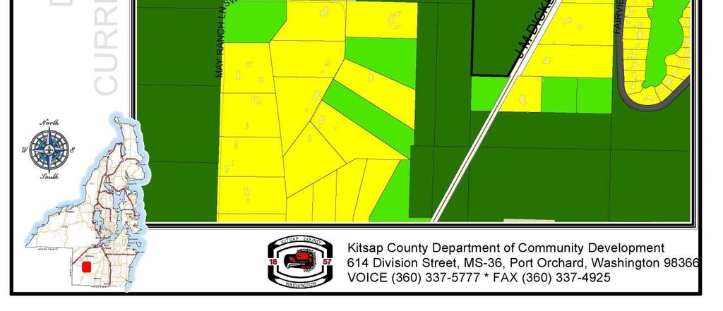
2 Submitted Application Materials Project application Reclassification request amendment criteria Ownership Certification Environmental Checklist Application Request The applicant seeks to reclassify and rezone five parcels from Rural Wooded (RW) to Rural Residential (RR). BACKGROUND The 5 subject properties contain a total of approximately acres and are classified by the Assessor as 880 Designated Forest Land. The Assessor s summary of this current use taxation classification is: A minimum of 20 contiguous acres, which must be primarily devoted to and used for growing and harvesting timber. Smaller parcels may qualify for timber land classification. If there is a residence on the parcel, a minimum 1 acre building site is excluded from the classification. (Kitsap County Assessor 2010, The subject sites currently do not have existing water, sewer, or electricity service. Well water and septic systems are proposed. The sites have access to JM Dickenson Road SW to the east and SW Lake Flora Road to the north. Additionally, three of the subject parcels contain wetlands, a fish bearing stream and moderate geologically hazardous areas as shown on County maps. (See Attachment 2). In February 2016, the application changed the requested zoning to Rural Protection (RP) instead of Rural Residential (RR). Surrounding Zoning and Land Use The subject properties are adjacent to parcels designated and zoned Rural Wooded or designated Public Facilities with Parks zoning and used as single family residential, parks, or forest land/resource production. See Exhibit 1. The subject property is part of a large contiguous area of land designated and zoned RW south of Bremerton and Port Orchard city boundaries. The area around Fairview Lake to the east across JM Dickenson Road was mainly developed prior to 1990 when the Growth Management Act (GMA) was enacted, and contains lots smaller than one acre in size with a Rural Residential designation. The surrounding lots are primarily sized between 5 10 acres. Comprehensive Plan Chapter 3 (Rural and Resource Lands) identifies the area immediately surrounding the lake as a Compact Rural Area, consisting of small residential lots at nearly 3 units per acre, with limited services. 2
3 Exhibit 1. Summary of Surrounding Areas Current Zoning and Land Use Location Current Zoning Current Land Use North East Park (P) RW RW RR Parcels north of SW Lake Flora Road consist of park land within the Coulter Creek Heritage Park Forest land Forest land Single family residential (part of Fairview Lake Compact Rural Area) South RW Single family residential West RW Forest land Single family residential Source: Kitsap County, 2015; BERK, 2015 Present Comprehensive Plan Map and Zoning Designations Current Comprehensive Plan and Zoning Designations The present Comprehensive Plan Map and zoning for the property is Rural Wooded Zone (RW). Rural Wooded (RW) designation: The RW designation is generally applied to larger parcels of land in contiguous blocks that are forested in character, that have been actively managed for forestry and harvested, and that may be currently taxed as timber lands pursuant to state and County programs. It is applied to lands that were formerly zoned as Interim Rural Forest. The objective of this designation is to allow continued forestry practices, provide ongoing opportunities for large and small scale timber management, and maintain large contiguous blocks of forested lands to protect significant environmental features, and allowing limited residential development in keeping with rural character. Environmental features may include significant visual, historic, and natural features; wildlife corridors; steep slopes; wetlands; streams; and adjacent critical areas. The RW designation is implemented by the Rural Wooded zone. Rural Wooded (RW) zone: is intended to encourage the preservation of forest uses, retain an area s rural character and conserve the natural resources while providing for some rural residential use. This zone is further intended to discourage activities and facilities that can be considered detrimental to the maintenance of timber production. Residents of RW residential tracts shall recognize that they can be subject to normal and accepted farming and forestry practices on adjacent parcels (Chapter Kitsap County Code [KCC]). This zone allows for forest resource uses and limited residential uses with a maximum density of 1 dwelling unit per 20 acres. Rural character is referenced in the RW designation and zone as well as all rural categories of the Comprehensive Plan and Zoning Code. Chapter 3 Rural and Resources Lands of the Comprehensive Plan has a detailed description of rural character as well as goals and policies. Some of the characteristics defining rural character include: Relatively undeveloped nature Lots 5 acres and over Agricultural and forest activities Land for wildlife and nature Wooded trail systems Views of the Hood Canal, Puget Sound, the Olympics and Mount Rainier Small businesses serving the local population Small, intimate communities 3
4 Personal open space for tranquility (enjoyment of personal property) Responsive public services, sense of being self sufficient Low population density Large forested areas Quiet two lane roads Proposed Comprehensive Plan and Zoning Designations As described in the current Comprehensive Plan, the proposed Comprehensive Plan Map and zoning designation is RP. As described in Chapter 3 of the Comprehensive Plan and the Kitsap County Code this designation promotes low density residential development consistent with rural character. It is applied to areas that are relatively unconstrained by environmentally sensitive areas or other significant landscape features. These areas are provided with limited public services (Chapter KCC). RR zoning has a maximum density of 1 dwelling unit per 5 acres. Under RR zoning, there are more permitted and conditional residential and commercial allowed uses than in the current RW zoning, such as a day care center, animal hospitals, golf course, and schools. The following tables compare the existing and proposed zoning designations for selected allowed uses and development standards. See Exhibit 2 and Exhibit 3. Exhibit 2. Selected Allowed Uses (KCC E) Selected Uses RP (proposed zoning) RW (current zoning) Residential Uses Single Family Attached C X Single Family Detached P P Manufactured Homes P X Mobile homes P P Commercial/Business Uses Daycare Center P X Kennels, pet care C X Nursery C X Golf course C X School C X Resource Land Uses Agricultural uses P P Forestry P P Legend: C = Conditional, P = Permitted, X = Prohibited Exhibit 3. Selected Development Standards Comparison (KCC ) Density and Dimensions RP (proposed zoning) RW (current zoning) Minimum lot size (acre) 5 20 Lot width (feet)
5 Density and Dimensions RP (proposed zoning) RW (current zoning) Lot depth (feet) Maximum height (feet) PUBLIC COMMENT The Washington State Department of Fish and Wildlife expresses concerns regarding the request. They site a fish bearing stream, identified as habitat for Coho salmon. They also identify this area as Priority Habitat, which provides fish habitat. Squaxin Island s Biologist commented via telephone that the Tribe does not oppose the request if all buffers can be met without variances. EVALUATION Site specific reclassification requests to the Comprehensive Plan must be reviewed in accordance with the criteria outlined in the Kitsap County Code (KCC) Chapter Applicable review criteria for site specific reclassification requests are in sections KCC A and KCC D. General Criteria (KCC A) A. General. For each proposed amendment to the Comprehensive Plan the review authority, the planning commission in reaching its recommendation, and the board of commissioners in making its decision, shall develop findings and conclusions, which demonstrate: 1. How circumstances related to the proposed amendment and/or the area in which the property affected by the proposed amendment is located have substantially changed since the adoption of the Comprehensive Plan or applicable development regulations; Circumstances related to the proposed amendment or area in which the property is located have not substantially changed since the adoption of the Comprehensive Plan or development regulations. Changes to surrounding area include annexation of the Puget Sound Industrial Center Bremerton and development of a high power transmission corridor. 2. How the assumptions upon which the Comprehensive Plan is based are no longer valid, or there is new information available which was not considered during the adoption of, or during the last annual amendment to, the Comprehensive Plan or development regulations; and The assumptions upon which the Comprehensive Plan is based are still generally valid. Updated growth targets and capacity analysis is being conducted as part of the 2016 Comprehensive Plan update, but in general that process will not change the assumptions relative to the subject property and proposed amendment. Based on intent language in the Kitsap County Comprehensive Plan, the subject properties more align with Rural Protection than Rural Wooded, as the majority of the lots are not wooded. 3. How the requested re designation is in the public interest and the proposal is consistent with the Kitsap County Comprehensive Plan. The County aims to focus a greater share of growth into the urban areas. The proposed amendment is inconsistent with this goal as it would increase development capacity in the rural area and alter the existing and logical boundary for the RW Zoning District along SW Lake Flora Road. The proposal could create additional development capacity on parcels with critical habitat, creating an inconsistency with the 5
6 Natural Systems Chapter. intent language. However, the redesignation better aligns with the Kitsap County Zoning code Reclassification Request Criteria Evaluation (KCC D) D. Site Specific Amendments. In addition to the findings and conclusions in subsection (A) of this section, a proposed site specific map amendment may be recommended for approval by the planning commission and may be approved by the board of commissioners if the following findings are made: 1. All Site Specific Amendment Requests. Each of the following requirements must be satisfied for a recommendation for approval. a. The proposed amendment meets concurrency requirements for transportation, sewer and water, and will not result in significant adverse impacts on adopted level of service standards for other public facilities and services, such as police, fire and emergency medical services, park services, and general government services; The parcels are currently undeveloped forest land and are not served by municipal water or sewer facilities. Well water is available, and septic systems are proposed. The sites are served by both SW Lake Flora Road and JM Dickenson Road SW. The proposed Comprehensive Plan map and zoning amendment would allow for up to 10 lots to be created at 10 acres per lot instead of 5 lots at 20 acres each. There are presently five lots under review in the application that are around 20 acres each and no new lots could be created under the RW zone. The 5 increased lots above existing lots could lead to an increase in the demand for police, fire and emergency medical services, as the number of new residences on the property would increase. An increase in residential development on the subject properties could also create an incremental demand for transportation maintenance and services within this rural area to reach necessary services in the surrounding rural and urban communities. b. The proposed amendment is consistent with the balance of the goals, policies and objectives of the current Kitsap County Comprehensive Plan and reflects the local circumstances of the County Kitsap County Comprehensive Plan Chapter Vision Kitsap County s Comprehensive Plan shows the relationship between chapter concepts and the comprehensive plan vision. See Exhibit 4. Exhibit 4. County Vision for Rural and Urban Areas Vision Rural Areas. Rural areas and communities where unique historical characters, appearances, functions, and pioneering spirits are retained and enhanced. Natural resource activities, such as forestry, agriculture, and mining continue to contribute to the rural character and economy. Rural recreation opportunities are enhanced, including equestrian facilities, trails, and others. Urban Areas. Healthy urban areas that are the region's centers for diverse employment and housing opportunities, all levels of education, and civic and cultural activities. Rural Chapter Relationship to Vision Maintain low residential densities in rural areas and provides policy guidance for development standards which help to preserve the County s rural character. Foster small sustainable farms and agricultural enterprises that provide locallygrown food and fiber for Kitsap citizens. Support focused development in urban areas as centers for population, employment, and civic and cultural activities (See the Land Use chapter 6
7 Source: Kitsap County Comprehensive Plan (December 2012). for further policy guidance affecting the urban area.) The proposed amendment would apply a designation that would provide for a rural character and allow development at rural densities, but it would be a pattern unlike those of abutting lands. Additionally, it would not support focusing development in urban areas. Kitsap County Comprehensive Plan 2036 Goals and Policies The proposed zoning amendment partially supports the following current Comprehensive Plan Goals: 3A.2.1 Rural Lands Goal 1: Retain the rural character of the County outside of designated urban areas, as described in this chapter. o o o Policy RL 1 Limit the designated rural area to low residential densities that can be sustained by minimal infrastructure improvements, cause minimal environmental degradation, and that will not cumulatively create the future necessity or expectation of urban levels of service. Policy RL 2 Provide a variety of densities in the rural areas to make more efficient use of land, maximize the return on public infrastructure investment, and provide for affordable housing opportunities. Policy RL 3 Permit residential uses in rural areas consistent with the existing and planned rural character of the surrounding area. The proposed RP designation would retain the rural character of the County at a rural density, but the proposal would increase the supply of land available for rural development when the County is looking to increase the percentage of growth that occurs in the urban areas. o Policy RL 4 Outside of the Type III LAMIRDs, limit development only to that which serves rural residential or resource needs and not draw people from UGAs. The proposed RP designation/zoning is intended to place residents near the Puget Sound Industrial Area Bremerton. It could increase the attractiveness of the rural area and set a precedent to reclassify land to RP in the area. Goal 19: Develop a long term strategy for addressing the future use of properties historically used for timber production, but currently designated as rural. The amendment request, if approved, would not encourage the continuation of forest lands as it would increase the likelihood that the properties are developed for residential use though at rural densities. However, as noted in the application packet, the subject properties do not have commercially viable timber, and therefore should be removed from the RW designation. c. The subject parcel(s) is suitable for the requested land use designation based upon, but not limited to, access, provision of utilities, consistency with existing and planned uses, environmental constraints and compatibility with the neighborhood; The subject parcels are currently undeveloped land and currently lack provision of municipal water and sewer facilities. Although the proposed RP zoning is compatible with existing land use as forest resource is an allowed use, it would encourage a greater rural residential density than is currently allowed for RW zoning and with abutting lands. More intense residential development may result in conversion of forestry uses; however the sites are not classified as forest lands of long term commercial significance. 7
8 While the proposed zoning change to RP would be compatible to some land use and zoning further to the north and east. A significant wetland system containing a fish bearing stream occurs on the eastern subject parcels. The buffers associated with this system would limit the land available for future residential development on these subject parcels. d. The proposed amendment does not materially affect the land uses and growth projections which are the basis for comprehensive planning, and reflects local circumstances in the county. The requested zoning amendment would not substantially affect current growth projections, but it could establish a precedent of converting properties from RW to RP that cumulatively has the potential to substantially increase the residential growth capacity in the rural area. e. The proposed amendment does not materially affect the adequacy or availability of urban facilities and services to the immediate area or the overall area of the urban growth area. The requested zoning amendment does not affect availability of urban facilities and services as the property is in the rural area. f. The proposed amendment is consistent with the GMA, Kitsap County wide Planning Policy, state and local laws and other applicable inter jurisdictional policies or agreements. The following state and local policies and laws are applicable to the applicant s zoning amendment request. Growth Management Act Planning Goals (RCW 36.70a.020) 1) Urban growth. Encourage development in urban areas where adequate public facilities and services exist or can be provided in an efficient manner. 2) Reduce sprawl. Reduce the inappropriate conversion of undeveloped land into sprawling, lowdensity development. 8) Natural resource industries. Maintain and enhance natural resource based industries, including productive timber, agricultural, and fisheries industries. Encourage the conservation of productive forest lands and productive agricultural lands, and discourage incompatible uses. (9) Open space and recreation. Retain open space, enhance recreational opportunities, conserve fish and wildlife habitat, increase access to natural resource lands and water, and develop parks and recreation facilities. (10) Environment. Protect the environment and enhance the state's high quality of life, including air and water quality, and the availability of water. The proposed RP zoning would support these GMA goals. The subject property is currently undeveloped forest land. If RR zoning is allowed, it would allow 5 more rural residential dwellings in rural areas beyond the five units allowed. Kitsap County wide Planning Policies Kitsap County wide Planning Policies, Element D contains planning policies for rural land uses and development patterns. Rural areas in Kitsap County are characterized as having a variety of parcel sizes, with a diversity of land use activities. These areas also contain significant amounts of complex natural systems. It is a high priority to preserve and enhance the rural character of these areas. D 1. Preserving rural character and enhancing the natural environment. 8
9 a. Preserve the character of identified rural areas by protecting and enhancing the natural environment, open spaces, recreational opportunities, and scenic and historic areas. Support small scale farming and working resource land, promote locally grown food, forestry, eco and heritage tourism. Support low density residential living and cluster development that provides for a mix of housing types, rural levels of service, cultural activities, and employment that services the needs of rural areas at a size and scale that is compatible with long term character, productivity, and use of these lands. A change to RP zoning would allow rural densities consistent with abutting properties. Future development would likely result in the removal of minor forest cover to a greater degree at 10 acre lots than at 20 acre lots; low impact development techniques may help reduce impacts. The applicant indicates that the properties may be attractive as hobby farms; that would allow for small scale agricultural resource uses instead of forest resource use. The 10 acre lots with hobby farms likely mean removal of trees beyond what is needed for homes, which could present problems for the stream and wetlands. These details will be analyzed at time of permit submittal. b. The County's Comprehensive Plan policies shall promote clustering residential development and other techniques to protect and enhance significant open spaces, natural resources, cultural resources, and critical areas for more effective use of the land. Clustering should not increase residential housing units in the overall area designated as rural, consistent with designated rural densities. Development clusters shall be designed, scaled and sited in a manner consistent with rural character and the provision of rural levels of service. The proponent indicates that the proposal would facilitate transfer of development rights and conservation easements which are not currently feasible on the Property given its low density yield. There is no specific development plan at this time and it is unknown what areas would be conserved other than the critical areas required for protection (the onsite high quality wetland). 4. Requests Within the Rural Area Not Pertaining to Commercial or Industrial Requests. If applicable, each of the following requirements must be satisfied for a recommendation of approval: a. Any proposed amendments to rural and natural resource areas shall not substantially affect the rural/urban population balance The proposed amendment does not substantially affect the rural/urban population balance. However, it encourages new residential development in sparsely developed wooded areas and could set a precedence for other land zoned RW to potentially change to RP and alter the current vicinity character which has larger lot rural patterns. b. Any proposed change to land designated as natural resource land shall recognize that natural resource designations are intended to be long term designations and shall further be dependent on one or more of the following: i. A substantial change in circumstances pertaining to the Comprehensive Plan or public policy; ii. A substantial change in circumstances beyond the control of the landowner pertaining to the subject property; iii. An error in initial designation; and/or iv. New information on natural resource land or critical area status According to the County Assessor website, all applicant properties are currently taxed as designated forest land recognizing the present use rather than the standard assessed value. However, the subject property is not designated as forest land of long term commercial significance. 9
10 Proposed Findings of Fact 1. The applicant, Apex Engineering, authorized agent/representative for the property owner, submitted the zoning amendment application to Kitsap County on February 25, The applicant seeks a Comprehensive Plan Amendment to change the land use map and associated zoning of five properties totaling acres from Rural Wooded (RW) to Rural Residential (RP). 3. The properties are located along SW Lake Flora Road in the rural area between Port Orchard and Bremerton in South Kitsap County. 4. The properties are currently undeveloped with no utility services. There are surveyed wetlands, a fish bearing stream and potential moderate geologically hazardous areas on the eastern subject parcels. 5. The eastern subject parcels have a substantial wetland according to County critical area maps. 6. The proposed RP zoning is consistent with the site. 7. The property is not contiguous to properties zoned RP. 8. The properties are in use for forestry purposes, but are not currently designated as resource lands of long term commercial significance. 9. The properties are included in the Preferred Alternative as Rural Protection. Conclusion of Law The revised Reclassification request does comply with all the provisions of the Washington State Growth Management Act, Kitsap County wide Planning Policies, and Kitsap County Comprehensive Plan. Recommendation Based on the findings of fact and conclusion of law staff recommends approval of application #
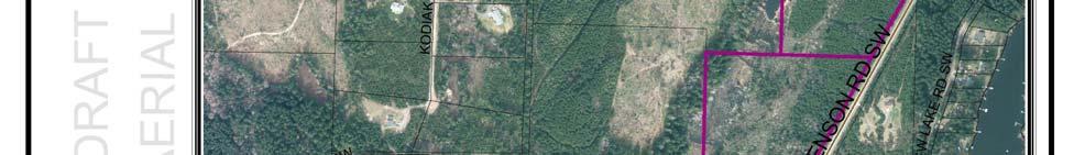

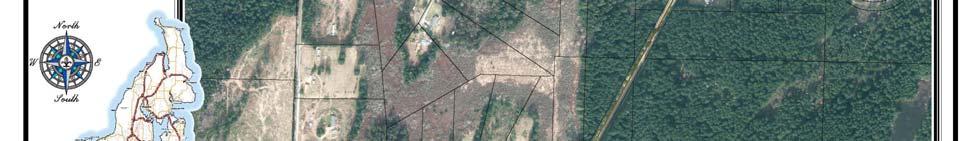
11 ATTACHMENTS Attachment Aerial Imagery 11
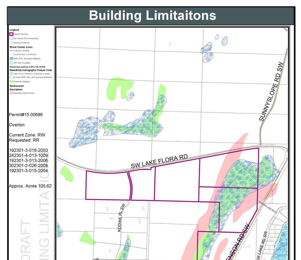
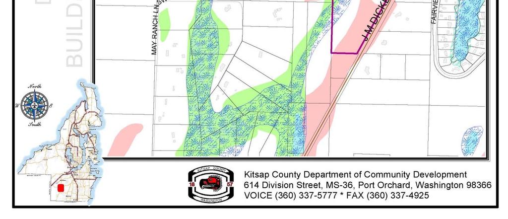
12 Attachment 2. Building Limitations 12
13 Attachment 3. Current Land Use Map 13
14 Attachment 4. Current Zoning 14
15 Attachment 5. Proposed Zoning 15
STAFF REPORT. Permit Number: Porter. Kitsap County Board of Commissioners; Kitsap County Planning Commission
 STAFF REPORT Permit Number: 15 00461 Porter DATE: November 9, 2015 TO: FROM: Kitsap County Board of Commissioners; Kitsap County Planning Commission Katrina Knutson, AICP, Senior Planner, DCD and Jeff
STAFF REPORT. Permit Number: Lee. Kitsap County Board of Commissioners; Kitsap County Planning Commission
 STAFF REPORT Permit Number: 15 00689 Lee DATE: March 2, 2016 TO: FROM: Kitsap County Board of Commissioners; Kitsap County Planning Commission Katrina Knutson, AICP, Senior Planner, DCD and Jeff Arango,
STAFF REPORT. Permit Number: Gonzalez. Kitsap County Board of Commissioners; Kitsap County Planning Commission
 STAFF REPORT Permit Number: 15 00657 Gonzalez DATE: March 2, 2016 TO: FROM: Kitsap County Board of Commissioners; Kitsap County Planning Commission Katrina Knutson, AICP, Senior Planner, DCD and Jeff Arango,
STAFF REPORT. Permit Number: Laurier Enterprises, Inc. Kitsap County Board of Commissioners; Kitsap County Planning Commission
 STAFF REPORT Permit Number: 15 00740 Laurier Enterprises, Inc. DATE: November 9, 2015 TO: FROM: Kitsap County Board of Commissioners; Kitsap County Planning Commission Katrina Knutson, AICP, Senior Planner,
STAFF REPORT. Permit Number: Laurier Enterprises, Inc. Kitsap County Board of Commissioners; Kitsap County Planning Commission
 STAFF REPORT Permit Number: 15 00740 Laurier Enterprises, Inc. DATE: December 18, 2015 TO: FROM: Kitsap County Board of Commissioners; Kitsap County Planning Commission Katrina Knutson, AICP, Senior Planner,
STAFF REPORT. Permit Number: DJM Construction. Kitsap County Board of Commissioners; Kitsap County Planning Commission
 STAFF REPORT Permit Number: 15 00378 DJM Construction DATE: November 9, 2015 TO: FROM: Kitsap County Board of Commissioners; Kitsap County Planning Commission Katrina Knutson, AICP, Senior Planner, DCD
STAFF REPORT. Permit Number: Unlimited. Kitsap County Board of Commissioners; Kitsap County Planning Commission
 STAFF REPORT Permit Number: 15 00550 Unlimited DATE: March 2, 2016 TO: FROM: Kitsap County Board of Commissioners; Kitsap County Planning Commission Katrina Knutson, AICP, Senior Planner, DCD and Jeff
Kitsap County Department of Community Development
 Kitsap County Department of Community Development Staff Report and Recommendation Annual Comprehensive Plan Amendment Process for 2018 Public Facility Designations and Park Classifications Update Report
Kitsap County Department of Community Development
 Kitsap County Department of Community Development Staff Report and Recommendation Annual Comprehensive Plan Amendment Process for 2018 George s Corner LAMIRD Boundary Adjustment Report Date 7/16/2018 Hearing
STAFF REPORT And INFORMATION FOR THE HEARING EXAMINER
 KITSAP COUNTY DEPARTMENT OF COMMUNITY DEVELOPMENT 614 DIVISION STREET MS-36, PORT ORCHARD WASHINGTON 98366-4682 Louisa Garbo, Director (360) 337-7181 FAX (360) 337-4925 HOME PAGE - www.kitsapgov.com/dcd/
Kitsap County Department of Community Development. Administrative Staff Report
 Kitsap County Department of Community Development Administrative Staff Report Report Date: Application Complete Date: March 15, 2018 Application Submittal Date: March 12, 2018 Project Name: Nikki Lee Salon
Kitsap County Department of Community Development. Staff Report and Administrative Decision
 Kitsap County Department of Community Development Report Date: Staff Report and Administrative Decision Application Complete Date: March 19, 2018 Application Submittal Date: March 19, 2018 To: Seth Hanson,
CCC XXX Rural Neighborhood Conservation (NC)
") CCC 33.10.XXX Rural Neighborhood Conservation (NC) Purpose: Maintain low density rural residential areas and associated uses commonly found in rural areas consistent with the local character of the distinctive
CCC 33.10.XXX Rural Neighborhood Conservation (NC) Purpose: Maintain low density rural residential areas and associated uses commonly found in rural areas consistent with the local character of the distinctive
PAPRlamird5-Four Seasons
 PAPRlamird5-Four Seasons Lamird Report This report provides the written record of local circumstances that explains how the 4 Seasons LAMIRD ( this lamird ) fits within the rural element goals of the Growth
Permit Number: Edwards Mountain View Meadows
 Notes and comments on 2016 Comp Plan Tom Nevins - Nov 24, 2015 These notes are being prepared prior to any public comment review, public hearing input, or Planning Commission discussion. These are initial
REPORT OF THE PLANNING AND DEVELOPMENT DEPARTMENT FOR APPLICATION FOR REZONING ORDINANCE TO PLANNED UNIT DEVELOPMENT MAY 18, 2017
 BEL REPORT OF THE PLANNING AND DEVELOPMENT DEPARTMENT FOR APPLICATION FOR REZONING ORDINANCE 2016-805 TO PLANNED UNIT DEVELOPMENT MAY 18, 2017 The Planning and Development Department hereby forwards to
Kitsap County Department of Community Development. Notice of Administrative Decision
 Kitsap County Department of Community Development Notice of Administrative Decision Date: March 27, 2018 To: Tammy Mabry, tammystattoostudio@gmail.com Interested Parties and Parties of Record RE: Permit
WENATCHEE PLANNING COMMISSION SCHEDULED MEETING October 15, 2014 WENATCHEE CITY HALL COUNCIL CHAMBERS 129 S. Chelan Avenue Wenatchee, WA AGENDA
 WENATCHEE PLANNING COMMISSION SCHEDULED MEETING October 15, 2014 WENATCHEE CITY HALL COUNCIL CHAMBERS 129 S. Chelan Avenue Wenatchee, WA 98801 AGENDA I. CALL TO ORDER: 5:30 PM II. ADMINISTRATIVE AFFAIRS
STAFF REPORT and INFORMATION FOR THE HEARING EXAMINER. Project: Westphal Accessory Dwelling Unit (ADU)
") KITSAP COUNTY DEPARTMENT OF COMMUNITY DEVELOPMENT 614 DIVISION STREET MS-36, PORT ORCHARD WASHINGTON 98366-4682 LARRY KEETON, DIRECTOR (360) 337-7181 FAX (360) 337-4925 HOME PAGE - www.kitsapgov.com STAFF
KITSAP COUNTY DEPARTMENT OF COMMUNITY DEVELOPMENT 614 DIVISION STREET MS-36, PORT ORCHARD WASHINGTON 98366-4682 LARRY KEETON, DIRECTOR (360) 337-7181 FAX (360) 337-4925 HOME PAGE - www.kitsapgov.com STAFF
891941, , : COMPREHENSIVE PLAN AMENDMENT, COMMUNITY PLAN AMENDMENT, AND AREA-WIDE MAP AMENDMENT
 Application Nos. 891941, 891909, 891940: COMPREHENSIVE PLAN AMENDMENT, COMMUNITY PLAN AMENDMENT, AND AREA-WIDE MAP AMENDMENT Amendments to designate five parcels as Rural Industrial Center in the Alderton
Kitsap County Department of Community Development. Notice of Hearing Examiner Decision
 Kitsap County Department of Community Development 10/09/2018 Notice of Hearing Examiner Decision To: RE: Interested Parties and Parties of Record Project Name: Green-Shire Accessory Dwelling Unit (ADU)
REPORT OF THE PLANNING AND DEVELOPMENT DEPARTMENT FOR APPLICATION FOR REZONING ORDINANCE TO PLANNED UNIT DEVELOPMENT SEPTEMBER 22, 2016
 BEL REPORT OF THE PLANNING AND DEVELOPMENT DEPARTMENT FOR APPLICATION FOR REZONING ORDINANCE 2016-576 TO PLANNED UNIT DEVELOPMENT SEPTEMBER 22, 2016 The Planning and Development Department hereby forwards
Kitsap County Department of Community Development. Administrative Staff Report
 Kitsap County Department of Community Development Administrative Staff Report Report Date: Application Submittal Date: October 25, 2017 Application Complete Date: October 25, 2017 Project Name: John s
GENERAL DESCRIPTION STAFF RECOMMENDATION IMPLEMENTATION REQUIREMENTS
 Application No.: 891418 Applicant: AREA-WIDE MAP AMENDMENT Rezone two parcels from Moderate Density Single Family (MSF) to Neighborhood Center (NC) and Employment Center (EC). Charles Bitton GENERAL DESCRIPTION
MIDWAY CITY Municipal Code
 MIDWAY CITY Municipal Code TITLE 9 ANNEXATION CHAPTER 9.01 PURPOSE CHAPTER 9.02 GENERAL REQUIREMENTS CHAPTER 9.03 PROPERTY OWNER INITIATION OF ANNEXATION CHAPTER 9.04 PROCEDURES FOR CONSIDERATION OF PETITION
Conservation Design Subdivisions
 Conservation Design Subdivisions An excerpt from the Rules and Regulations Governing Division of Land in Sheridan County, Wyoming, November 5, 2010 Sheridan County Public Works Department 224 S. Main Street
TREASURE COAST REGIONAL PLANNING COUNCIL M E M O R A N D U M
 TREASURE COAST REGIONAL PLANNING COUNCIL M E M O R A N D U M To: Council Members AGENDA ITEM 6A From: Date: Subject: Staff May 20, 2011 Council Meeting Local Government Comprehensive Plan Review Draft
MEMORANDUM. Critical Areas Ordinance Density Requirements
 COUNTY COMMISSIONERS Creating Solutions for Our Future Cathy Wolfe District One Sandra Romero District Two Karen Valenzuela District Three PLANNING DEPARTMENT Scott Clark Director MEMORANDUM TO: FROM:
Marion County Board of County Commissioners
 Marion County Board of County Commissioners Date: 12/29/2015 P&Z: 12/28/2015 BCC: 1/12/2016 Item Number 160113Z Type of Application Rezoning Request From: A-1 (General Agriculture) To: PUD (Planned Unit
Cover Letter with Narrative Statement
 Cover Letter with Narrative Statement March 31, 2017 rev July 27, 2017 RE: Rushton Pointe Residential Planned Unit Development Application for Public Hearing for RPUD Rezone PL2015 000 0306 Mr. Eric Johnson,
Staff Report to the Clallam County Planning Commission March 2, 2004 Page 1
 March 2, 2004 Page 1 Comprehensive Plan and Zoning Map Amendment REZ2003-00001, Staff Report Clallam County Department of Community Development January 27, 2004 Prepared by the Clallam County Department
Forest Service Role CHAPTER 2
 CHAPTER 2 Forest Service Role Implementation of the Management Plan charters a federal presence with an expanded focus beyond traditional Forest Service roles. In addition to administration of the National
2030 General Plan. December 6, 7 pm
 2030 General Plan GPAC Meeting #9 GPAC Meeting #9 December 6, 7 pm City Council Input on Working Draft Land Use Map Council discussed GPAC & PC versions of the working draft land use map 11/28 Council
Kitsap County Hearing Examiner
 January 25, 2016 ADMINISTRATION BUILDING, 619 DIVISION ST, MS-36 PORT ORCHARD, WA 98366 http://www.kitsapgov.com/dcd/lu_env/he/ (360) 337-5777 NOTICE OF HEARING EXAMINER DECISION To: Interested Parties
LETTER OF TRANSMITTAL
 LETTER OF TRANSMITTAL To: Clallam County Board of Commissioners From: Clallam County Planning Commission Date: November 18, 2009 Subject: Transmittal to BOCC: Findings and Conclusions regarding proposed
Notice of Continuance Land Classified as Current Use or Forest Land RCW Chapter and 84.33
 When Recorded Return to: Notice of Continuance Land Classified as Current Use or Forest Land RCW Chapter 84.34 and 84.33 Grantor(s)/Sellers: Grantee(s)/Buyers: Mailing Address: City, State, Zip: Assessor
Pierce County Comprehensive Plan Review
 2015-2016 Pierce County Comprehensive Plan Review March 16, 2016 Introduction Planning and Management Policies Some of the policies governing both the planning and management of growth and change within
APPLICATION FOR SUBDIVISION APPROVAL OF A SKETCH PLAN with checklist
 Prior to filing any application for SUBDIVISION approval, the applicant shall request in writing that the zoning administrator schedule a pre-submission conference. APPLICATION TO THE PLANNING BOARD TOWN
STANDARDS FOR EVALUATING PROPOSALS
 STANDARDS FOR EVALUATING PROPOSALS Amended by Resolution No. 2011-1; February 2, 2011 Pursuant to Government Code Section 56375, Santa Cruz LAFCO has established standards for the evaluation of proposals.
4.2 LAND USE INTRODUCTION
 4.2 LAND USE INTRODUCTION This section of the EIR addresses potential impacts from the Fresno County General Plan Update on land use in two general areas: land use compatibility and plan consistency. Under
CITY OF NORTH LAS VEGAS MEMORANDUM
 CITY OF NORTH LAS VEGAS MEMORANDUM TO: FROM: SUBJECT: Planning Commission Community Development and Compliance Department # 28 ) AMP-03-15; Coleman Airpark II & III - Comprehensive Plan Amendment (Public
MEMORANDUM Clallam County Department of Community Development
 MEMORANDUM Clallam County Department of Community Development Date: August 1, 2007 To: Clallam County Planning Commission From: DCD, Planning Division Re: Rezone and Comprehensive Plan and Zoning Map Amendment
Claudia Stuart, Williamson Act Program Manager and Nick Hernandez, Planning Intern
 Land Conservation (Williamson) Act Advisory Committee STAFF REPORT September 15, 2014 Prepared by: Claudia Stuart, Williamson Act Program Manager and Nick Hernandez, Planning Intern Subject: Discussion:
Planning Department Oconee County, Georgia
 Planning Department Oconee County, Georgia STAFF REPORT REZONE CASE #: 6985 DATE: October 31, 2016 STAFF REPORT BY: Andrew C. Stern, Planner APPLICANT NAME: Williams & Associates, Land Planners PC PROPERTY
Chapter 100 Planned Unit Development in Corvallis Urban Fringe
 100.100 Scope and Purpose. Chapter 100 Planned Unit Development in Corvallis Urban Fringe (1) All applications for land divisions in the Urban Residential (UR) and Flood Plain Agriculture (FPA) zones within
BROCHURE # 37 OPEN SPACE
 BROCHURE # 37 OPEN SPACE The information and instructions in this publication are to be used when applying for assessment on the basis of current use under the open space laws, chapter 84.34 RCW and chapter
FINAL DRAFT 12/1/16, Rev. to 7/18/17
 FINAL DRAFT 12/1/16, Rev. to 7/18/17 (As Adopted 8/8/17 Effective 9/1/17) SHELTON PLANNING AND ZONING COMMISSION Proposed Amendments to Zoning Regulations I. Amend Section 23 PERMITTED USES by inserting
GWINNETT COUNTY CSO CONSERVATION SUBDIVISION OVERLAY DISTRICT REQUIREMENTS
 GWINNETT COUNTY CSO CONSERVATION SUBDIVISION OVERLAY DISTRICT REQUIREMENTS Section 1316. CSO Conservation Subdivision Overlay District. 1. Purposes. The purposes of this overlay district are as follows:
Georgia Conservation Tax Credit Program Frequently Asked Questions
 Georgia Conservation Tax Credit Program Frequently Asked Questions What are the minimum requirements for eligibility under the Georgia Conservation Tax Credit Program (GCTCP)? Individual and corporate
Board of County Commissioners Agenda Request
 Board of County Commissioners Agenda Request Date of Meeting: March 26, 2019 Date Submitted: March 19, 2019 To: From: Agenda Location: Subject: Honorable Chairman and Members of the Board Margaret Emblidge,
78th OREGON LEGISLATIVE ASSEMBLY Regular Session. House Bill 2510 SUMMARY
 th OREGON LEGISLATIVE ASSEMBLY--0 Regular Session Sponsored by Representative CLEM (Presession filed.) House Bill 0 SUMMARY The following summary is not prepared by the sponsors of the measure and is not
CITY OF PORT ORCHARD
 CITY OF PORT ORCHARD ZONING DESIGNATIONS (Adapted from POMC Chapter 20.34 Zoning Districts, as adopted 6/13/2017) 20.34.110 Greenbelt zone (Gb). (1) Purpose. It is the purpose of the greenbelt zone to
IRS FORM 8283 SUPPLEMENTAL STATEMENT DONATION OF CONSERVATION EASEMENT
 Name(s) shown on income tax return Identifying Number Robert T. Landowner 021-34-1234 Susan B. Landowner 083-23-5555 IRS FORM 8283 SUPPLEMENTAL STATEMENT DONATION OF CONSERVATION EASEMENT On November 12,
ARTICLE III District Regulations. A map entitled "Franklin Zoning Map" is hereby adopted as part of this chapter 1.
 ARTICLE III District Regulations ~ 305-8. Adoption of Zoning Map. A map entitled "Franklin Zoning Map" is hereby adopted as part of this chapter 1. ~ 305-9. Official Zoning Map; amendments. Regardless
City of Bellingham Urban Growth Area - Land Supply Analysis Summary
 City of Bellingham Urban Growth Area - Land Supply Analysis Summary Population & Employment Growth Forecasts APPENDIX D, ATTACHMENT 3 The ECONorthwest Whatcom County Population & Economic Forecasts report
PAPRlamird4-Lairds Corner
 PAPRlamird4-Lairds Corner Lamird Report This report provides the written record of local circumstances that explains how the Lairds Corner LAMIRD ( this lamird ) fits within the rural element goals of
Open Space Taxation Act
 Open Space Taxation Act WASHINGTON STATE DEPARTMENT OF REVENUE JUNE 2007 The information and instructions in this brochure are to be used when applying for assessment on the basis of current use under
1. Future Land Use FLU6.6.8 Land uses within the Rural Service Area portion of the Wekiva Study Area shall be limited to very low and low intensity
 1. Future Land Use FLU6.6.8 Land uses within the Rural Service Area portion of the Wekiva Study Area shall be limited to very low and low intensity uses to the greatest extent possible. Existing land uses
Rezone property from RR(T)D3, D1(T)D3, and RR(T)D15 to D3 and D15 along North Douglas Highway.
D3, D1(T)D3, and RR(T)D15 to D3 and D15 along North Douglas Highway.") DATE: TO: FROM: Planning Commission Chrissy McNally, Planner Community Development Department FILE NO.: AME2013 0016 PROPOSAL: Rezone property from RR(T)D3, D1(T)D3, and RR(T)D15 to D3 and D15 along North
DATE: TO: FROM: Planning Commission Chrissy McNally, Planner Community Development Department FILE NO.: AME2013 0016 PROPOSAL: Rezone property from RR(T)D3, D1(T)D3, and RR(T)D15 to D3 and D15 along North
Village WASHINGTON TOWNSHIP MASTER PLAN SYNTHESIS. Page 197
 Village P l a n WASHINGTON TOWNSHIP MASTER PLAN SYNTHESIS Page 197 SECTION 11.0 MASTER PLAN SYNTHESIS INTRODUCTION The proposals presented in the various plans result in a graphic synthesis: The Land Use
Procedures For Collecting and Monitoring Data
 DRAFT Kitsap County Buildable Lands Program Procedures For Collecting and Monitoring Data Page 1 12/1/05 Introduction This procedures report is intended to provide guidelines for Kitsap County and its
Comprehensive Plan /24/01
 IV The is a central component of the Comprehensive Plan. It is an extension of the general goals and policies of the community, as well as a reflection of previous development decisions and the physical
A. Preserve natural resources as identified in the Comprehensive Plan.
 1370.08 Conservation Residential Overlay District. Subd. 1 Findings. The City finds that the lands and resources within the Conservation Residential Overlay District are a unique and valuable resource
Title 6 - Local Government Provisions Applicable to Special Purpose Districts and Other Political Subdivisions
 Title 6 - Local Government Provisions Applicable to Special Purpose Districts and Other Political Subdivisions CHAPTER 29. SOUTH CAROLINA LOCAL GOVERNMENT COMPREHENSIVE PLANNING ENABLING ACT OF 1994 1994
Notice of Continuance Land Classified as Current Use or Forest Land Chapter and Revised Code of Washington
 When Recorded Return to: Cowlitz County Assessor s Office Attn: Forest Land / Current Use Dept 207 N 4 th Avenue Kelso WA 98626 Notice of Continuance Land Classified as Current Use or Forest Land Chapter
Midwest City, Oklahoma Zoning Ordinance
 2010 Midwest City, Oklahoma Zoning Ordinance 9/2/2010 Table of Contents Section 1. General Provisions... 5 1.1. Citation... 5 1.2. Authority... 5 1.3. Purpose... 5 1.4. Nature and Application... 5 1.5.
Be Happy, Stay Rural!
 Be Happy, Stay Rural! Board of Directors: Diane Neubert, President Judy Lawrence, Vice President Cindy Ellsmore, Treasurer Linda Frost, Secretary Stevee Duber, Project Manager stevee@highsierrarural.org
APPLICATION INFORMATION Site Information Parcel Number Street Address Applicant Information Name Street Address City State Zip
 Comprehensive Plan Amendment City of Puyallup Development Services 333 S. Meridian Puyallup, WA 98371 Phone: 253-864-4165 www.cityofpuyallup.org Submittal Checklist Application is signed and dated 5 Copies
Land Use. Land Use Categories. Chart 5.1. Nepeuskun Existing Land Use Inventory. Overview
 Land Use State Comprehensive Planning Requirements for this Chapter A compilation of objectives, policies, goals, maps and programs to guide the future development and redevelopment of public and private
Planned Unit Development (PUD). Sections:
. Sections:") Chapter 19.07. Planned Unit Development (PUD). Sections: 19.07.01. Purpose. 19.07.02. PUD Definition and Design Compatibility. 19.07.03. General PUD Standards. 19.07.04. Underlying Zones. 19.07.05. Permitted
Chapter 19.07. Planned Unit Development (PUD). Sections: 19.07.01. Purpose. 19.07.02. PUD Definition and Design Compatibility. 19.07.03. General PUD Standards. 19.07.04. Underlying Zones. 19.07.05. Permitted
Town of Falmouth s Four Step Design Process for Subdivisions in the Resource Conservation Zoning Overlay District
 Town of Falmouth s Four Step Design Process for Subdivisions in the Resource Conservation Zoning Overlay District All subdivisions shall be designed in accordance with the following four-step process.
Open Space Taxation Act JULY 2017
 Open Space Taxation Act JULY 2017 The information and instructions in this publication are to be used when applying for assessment on the basis of current use under the open space laws, chapter 84.34 RCW
Appendix A: Guide to Zoning Categories Prince George's County, Maryland
 Appendix A: Guide to Zoning Categories Prince George's County, Maryland RESIDENTIAL ZONES 1 Updated November 2010 R-O-S: Reserved Open Space - Provides for permanent maintenance of certain areas of land
Planning Commission Application Summary
 Planning Commission Application Summary Project Name: Creekside Estates Zone Change and Land Use Amendment Address: 571 West 11400 South Current Zoning: RA1 Hearing Date: July 14, 2016 Summary of Request
FUTURE LAND USE. City of St. Augustine Comprehensive Plan EAR-Based Amendments
 FUTURE LAND USE City of St. Augustine Comprehensive Plan EAR-Based Amendments Future Land Use Element FLU Goal To create an environment within the City and adjacent areas in which its residents have the
HENDRY COUNTY PLANNING & ZONING DEPARTMENT POST OFFICE BOX S. MAIN STREET LABELLE, FLORIDA (863) FAX: (863)
 FAX: (863)") HENDRY COUNTY PLANNING & ZONING DEPARTMENT POST OFFICE BOX 2340 640 S. MAIN STREET LABELLE, FLORIDA 33975 (863) 675-5240 FAX: (863) 674-4194 STAFF REPORT CPA19-0001 Comprehensive Plan Map Amendment Local
HENDRY COUNTY PLANNING & ZONING DEPARTMENT POST OFFICE BOX 2340 640 S. MAIN STREET LABELLE, FLORIDA 33975 (863) 675-5240 FAX: (863) 674-4194 STAFF REPORT CPA19-0001 Comprehensive Plan Map Amendment Local
Multiple Use Forest District (MUF)
") This district is defined as Multiple Use Forest District with a minimum lot size of 20 acres. 11.15.2162 Purposes The purposes of the Multiple Use Forest District are to conserve and encourage the use
This district is defined as Multiple Use Forest District with a minimum lot size of 20 acres. 11.15.2162 Purposes The purposes of the Multiple Use Forest District are to conserve and encourage the use
SANTA BARBARA COUNTY ZONING ADMINISTRATOR STAFF REPORT February 15, 2013
 SANTA BARBARA COUNTY ZONING ADMINISTRATOR STAFF REPORT February 15, 2013 PROJECT: Galbraith Lot Line Adjustment HEARING DATE: March 4, 2013 STAFF/PHONE: J. Ritterbeck, (805) 568-3509 GENERAL INFORMATION
PLANNING FOR OUR FUTURE
 PLANNING FOR OUR FUTURE ELLSWORTH TOWNSHIP LAND USE AND POLICY PLAN The purpose of this Plan is to serve as a guide for the Township Trustees, Zoning Commission, Board of Zoning Appeals, developers, employers,
Appendix A: Urban Growth Boundary, Measure H
 Appendix A: Urban Growth Boundary, Measure H The following policy revisions, shown in track changes, reflect the proposed General Plan text amendment included in Measure H, which will be placed on the
REZONING APPLICATION INSTRUCTIONS
 REZONING APPLICATION INSTRUCTIONS All required information, as stated on the Rezoning Application Checklist, must be included to qualify as a complete application. Upon receipt, staff will review the application
Implementation. Approved Master Plan and SMA for Henson Creek-South Potomac 103
 Implementation Approved Master Plan and SMA for Henson Creek-South Potomac 103 104 Approved Master Plan and SMA for Henson Creek-South Potomac Sectional Map Amendment The land use recommendations in the
Urban Fringe Development Area Project Update And Staff Recommendation
 Urban Fringe Development Area Project Update And Staff Recommendation July 30, 2008 July 30, 2008 Urban Fringe Development Area Project Table of Contents Introduction, Background, and Next Steps 3 Constraints:
Metropolitan Planning Commission. DATE: April 5, 2016
 TO: FROM: Metropolitan Planning Commission MPC Staff DATE: April 5, 2016 SUBJECT: Petition of Nine Line Inc. Robert McCorkle, Agent PIN: 2-1034-01-002 380.5 Acres Aldermanic District: 5 (Shabazz) County
United States Post Office and Multi-Family Residential; and, Single- Family Residence with an Apartment
 Planning Commission File No.: AME2013 0009 January 9, 2014 Page 2 of 9 Existing Land Use: United States Post Office and Multi-Family Residential; and, Single- Family Residence with an Apartment Surrounding
CHAPTER Committee Substitute for Committee Substitute for Senate Bill No. 2188
 CHAPTER 2004-372 Committee Substitute for Committee Substitute for Senate Bill No. 2188 An act relating to land development; amending s. 197.502, F.S.; providing for the issuance of an escheatment tax
City of Astoria Comprehensive Plan URBAN GROWTH
 URBAN GROWTH CP.110 CP.110. Background Summary. Astoria has a population of 9,477 (2010 US Census). The total land area within the Urban Growth Boundary (UGB) is 3,474.2 acres with total land area of 4,450
8Land Use. The Land Use Plan consists of the following elements:
 8Land Use 1. Introduction The Land Use Plan consists of the following elements: 1. Introduction 2. Existing Conditions 3. Opportunities for Redevelopment 4. Land Use Projections 5. Future Land Use Policies
TRANSFER OF DEVELOPMENT RIGHTS (TDR) ORDINANCE Revised November 2013
 ORDINANCE Revised November 2013") ARTICLE III Transfer of Development Rights (TDR) Program Part 301 Establishment and Purpose. 165-301.01. Purpose. Pursuant to the authority granted by 15.2-2316.1 and 2316.2 of the Code of Virginia, there
ARTICLE III Transfer of Development Rights (TDR) Program Part 301 Establishment and Purpose. 165-301.01. Purpose. Pursuant to the authority granted by 15.2-2316.1 and 2316.2 of the Code of Virginia, there
PALM BEACH COUNTY PLANNING, ZONING AND BUILDING DEPARTMENT ZONING DIVISION
 PALM BEACH COUNTY PLANNING, ZONING AND BUILDING DEPARTMENT ZONING DIVISION Application No.: Z-2014-01627 Application Name: Dazco Center Control No.: 2003-00040 Applicant: 4730 Hypoluxo LLC Owners: 4730
Article Optional Method Requirements
 Article 59-6. Optional Method Requirements [DIV. 6.1. MPDU DEVELOPMENT IN RURAL RESIDENTIAL AND RESIDENTIAL ZONES Sec. 6.1.1. General Requirements... 6 2 Sec. 6.1.2. General Site and Building Type Mix...
Instructions: Script:
 Before the course, select four of the 11 tool topics to insert into the presentation, including at least one tool from each of the three goal categories. Replace each tool placeholder slide with the slides
4. facilitate the construction of streets, utilities and public services in a more economical and efficient manner;
 PVPC MODEL BYLAW BY-RIGHT CLUSTER ZONING BYLAW Prepared by Pioneer Valley Planning Commission Revised: October 2001 1.00 Development 1.01 Development Allowed By Right Development in accordance with this
UNOFFICIAL COPY OF HOUSE BILL 1272 A BILL ENTITLED
 UNOFFICIAL COPY OF HOUSE BILL 1272 M4 6lr0525 By: Delegates Smigiel, Kelley, Rosenberg, and Sossi Introduced and read first time: February 10, 2006 Assigned to: Environmental Matters 1 AN ACT concerning
Chapter Planned Residential Development Overlay
 Chapter 19.29 Planned Residential Development Overlay Sections 010 Purpose 020 Scope 030 Definitions 030 Minimum Size 040 Allowable Uses 050 Minimum Development Standards 060 Density Bonus 070 Open Space
Craig L. Miller, Attorney 230 East Fifth Street Port Angeles, WA 98362
 Comprehensive Plan and Zoning Map Amendment REZ2003-00003, Staff Report Clallam County Department of Community Development Prepared by the Clallam County Department of Community Development, Planning Division
Larimer County Planning Dept. Procedural Guide for 1041 PERMITS
 - Larimer County Planning Dept. Procedural Guide for 1041 PERMITS PLEASE NOTE: A PRE-APPLICATION CONFERENCE IS REQUIRED PRIOR TO SUBMITTING THIS APPLICATION. PURPOSE: State Statutes allow local governments
4. If any perennial surface water passes through or along the property lines of the acreage, a minimum of 200 feet or frontage should be required.
 b. Provide adequate acreage for appropriate productive use of rural residential land, such as small numbers of livestock, large gardens, etc. 3. Minimum of 200 feet of frontage on an improved county or
ARTICLE XI - CONSERVATION SUBDIVISIONS
 ARTICLE XI - CONSERVATION SUBDIVISIONS Section 1101: Purpose and Intent. This Article is intended to provide for residential subdivisions that are designed based first and foremost on the preservation
INDIAN RIVER COUNTY, FLORIDA. The Honorable Members of the Planning and Zoning Commission DEPARTMENT HEAD CONCURRENCE
 Public Hearing Legislative INDIAN RIVER COUNTY, FLORIDA M E M O R A N D U M TO: The Honorable Members of the Planning and Zoning Commission DEPARTMENT HEAD CONCURRENCE Robert M. Keating, AICP; Community