MUNICIPAL-GWINNETT COUNTY PLANNING COMMISSION PUBLIC HEARING AGENDA
|
|
|
- Vivian Lawson
- 6 years ago
- Views:
Transcription
1 MUNICIPAL-GWINNETT COUNTY PLANNING COMMISSION PUBLIC HEARING AGENDA GWINNETT JUSTICE AND ADMINISTRATION CENTER WEDNESDAY, DECEMBER 7, 2016 AT 7:00 P.M. AS SET FORTH IN THE AMERICANS WITH DISABILITIES ACT OF 1992, THE GWINNETT COUNTY GOVERNMENT DOES NOT DISCRIMINATE ON THE BASIS OF DISABILITY AND WILL ASSIST CITIZENS WITH SPECIAL NEEDS GIVEN PROPER NOTICE (SEVEN WORKING DAYS). FOR INFORMATION, PLEASE CALL THE FACILITIES MANAGEMENT DIVISION AT A. CALL TO ORDER, INVOCATION, PLEDGE TO FLAG B. OPENING REMARKS BY CHAIRMAN AND RULES OF ORDER C. APPROVAL OF AGENDA D. APPROVAL OF MINUTES (NOVEMBER 1, 2016 MEETING) E. ANNOUNCEMENTS F. OLD BUSINESS 1. CASE NUMBER :RZR (PUBLIC HEARING HELD) APPLICANT :CKK DEVELOPMENT SERVICES CONTACT :DUNCAN CORLEY PHONE NUMBER : ZONING CHANGE :R-100 TO R-60 LOCATION : BLOCK OF HOKE O KELLY MILL ROAD MAP NUMBER :R ACREAGE :19.67 ACRES UNITS :54 UNITS PROPOSED DEVELOPMENT :SINGLE FAMILY SUBDIVISION COMMISSION DISTRICT :(3) HUNTER DEPARTMENT RECOMMENDATION :APPROVAL WITH CONDITIONS AS R-75
2 Planning Commission Agenda December 7, 2016 Page 2 2. CASE NUMBER :CIC APPLICANT :O. DAVID DENARD CONTACT :ERIC JOHANSEN, RLA PHONE NUMBER : ZONING :M-1 LOCATION : BLOCKS OF PLEASANTDALE ROAD MAP NUMBER :R6246A 237 ACREAGE :1.59 ACRES PROPOSED DEVELOPMENT :CHANGE IN CONDITIONS TO REVISE USE RESTRICTIONS COMMISSION DISTRICT :(2) HOWARD DEPARTMENT RECOMMENDATION :DENIAL 3. CASE NUMBER :SUP APPLICANT :O. DAVID DENARD CONTACT :ERIC JOHANSEN, RLA PHONE NUMBER : ZONING :M-1 LOCATION : BLOCK OF PLEASANTDALE ROAD MAP NUMBER :R6246A 237 ACREAGE :1.59 ACRES PROPOSED DEVELOPMENT :TOWING/WRECKER SERVICE & VEHICLE STORAGE LOT COMMISSION DISTRICT :(2) HOWARD DEPARTMENT RECOMMENDATION :DENIAL 4. CASE NUMBER :BRD APPLICANT :JONG IN LEE CONTACT :JONG LEE PHONE NUMBER : ZONING :RA-200 LOCATION :1600 BLOCK OF OLD FOUNTAIN ROAD MAP NUMBER :R ACREAGE :6.64 ACRES PROPOSED DEVELOPMENT :REDUCTION IN BUFFER FROM 20 FEET TO 11 FEET COMMISSION DISTRICT :(4) HEARD DEPARTMENT RECOMMENDATION :DENIAL
3 Planning Commission Agenda December 7, 2016 Page 3 G. NEW BUSINESS 1. CASE NUMBER :RZC APPLICANT :RACETRAC PETROLEUM, INC. CONTACT :SHANE LANHAM PHONE NUMBER : ZONING CHANGE :M-1 TO C-2 LOCATION :4500 BLOCK OF SHACKLEFORD ROAD :4400 BLOCK OF TIMMERS WAY :1700 BLOCK OF BEAVER RUIN ROAD MAP NUMBERS :R & 003 ACREAGE :2.33 ACRES SQUARE FEET :5,500 SQUARE FEET PROPOSED DEVELOPMENT :CONVENIENCE STORE WITH FUEL PUMPS COMMISSION DISTRICT :(1) BROOKS DEPARTMENT RECOMMENDATION :APPROVAL WITH CONDITIONS 2. CASE NUMBER :RZC APPLICANT :CLAUDIU RATIU CONTACT :CLAUDIU RATIU PHONE NUMBER : ZONING CHANGE :RA-200 TO O-I LOCATION :3000 HOG MOUNTAIN ROAD MAP NUMBER :R ACREAGE :1.2 ACRES SQUARE FEET :4,923 SQUARE FEET PROPOSED DEVELOPMENT :CONGREGATE PERSONAL CARE HOME (BUFFER REDUCTION) COMMISSION DISTRICT :(3) HUNTER DEPARTMENT RECOMMENDATION :DENIAL 3. CASE NUMBER :SUP APPLICANT :CLAUDIU RATIU CONTACT :CLAUDIU RATIU PHONE NUMBER : ZONING :O-I (PROPOSED) LOCATION :3000 HOG MOUNTAIN ROAD MAP NUMBER :R ACREAGE :1.2 ACRES SQUARE FEET :4,923 SQUARE FEET PROPOSED DEVELOPMENT :CONGREGATE PERSONAL CARE HOME COMMISSION DISTRICT :(3) HUNTER DEPARTMENT RECOMMENDATION :DENIAL
4 Planning Commission Agenda December 7, 2016 Page 4 4. CASE NUMBER :RZC APPLICANT :CLAUDIU RATIU CONTACT :CLAUDIU RATIU PHONE NUMBER : ZONING CHANGE :RA-200 TO O-I LOCATION :3100 HOG MOUNTAIN ROAD MAP NUMBER :R ACREAGE :3.99 ACRES SQUARE FEET :6,020 SQUARE FEET PROPOSED DEVELOPMENT :CONGREGATE PERSONAL CARE HOME (BUFFER REDUCTION) COMMISSION DISTRICT :(3) HUNTER DEPARTMENT RECOMMENDATION :DENIAL 5. CASE NUMBER :SUP APPLICANT :CLAUDIU RATIU CONTACT :CLAUDIU RATIU PHONE NUMBER : ZONING :O-I (PROPOSED) LOCATION :3100 HOG MOUNTAIN ROAD MAP NUMBER :R ACREAGE :3.99 ACRES SQUARE FEET :6,020 SQUARE FEET PROPOSED DEVELOPMENT :CONGREGATE PERSONAL CARE HOME COMMISSION DISTRICT :(3) HUNTER DEPARTMENT RECOMMENDATION :DENIAL 6. CASE NUMBER :RZC APPLICANT :MANSIONS SENIOR LIVING CONTACT :JULIE L. SELLERS PHONE NUMBER : ZONING CHANGE :MUO TO O-I LOCATION :2400 BLOCK OF BUFORD DRIVE :1000 BLOCK OF OLD PEACHTREE ROAD MAP NUMBERS :R & R C ACREAGE :19.21 ACRES SQUARE FEET :248,000 SQUARE FEET PROPOSED DEVELOPMENT :RETIREMENT COMMUNITY (BUFFER REDUCTION) COMMISSION DISTRICT :(1) BROOKS DEPARTMENT RECOMMENDATION :APPROVAL WITH CONDITIONS
5 Planning Commission Agenda December 7, 2016 Page 5 7. CASE NUMBER :SUP APPLICANT :MANSIONS SENIOR LIVING CONTACT :JULIE L. SELLERS PHONE NUMBER : ZONING :O-I (PROPOSED) LOCATION :2400 BLOCK OF BUFORD DRIVE :1000 BLOCK OF OLD PEACHTREE ROAD MAP NUMBERS :R & R C ACREAGE :19.21 ACRES SQUARE FEET :248,000 SQUARE FEET PROPOSED DEVELOPMENT :RETIREMENT COMMUNITY (BUFFER REDUCTION) COMMISSION DISTRICT :(1) BROOKS DEPARTMENT RECOMMENDATION :APPROVAL WITH CONDITIONS 8. CASE NUMBER :SUP APPLICANT :MANSIONS SENIOR LIVING CONTACT :JULIE L. SELLERS PHONE NUMBER : ZONING :O-I (PROPOSED) LOCATION :2400 BLOCK OF BUFORD DRIVE :1000 BLOCK OF OLD PEACHTREE ROAD MAP NUMBERS :R & R C ACREAGE :19.21 ACRES SQUARE FEET :248,000 SQUARE FEET PROPOSED DEVELOPMENT :BUILDING HEIGHT INCREASE COMMISSION DISTRICT :(1) BROOKS DEPARTMENT RECOMMENDATION :APPROVAL WITH CONDITIONS 9. CASE NUMBER :RZC APPLICANT :NETHERWORLD HAUNTED ATTRACTIONS, LLC CONTACT :SHANE LAMHAM PHONE NUMBER : ZONING CHANGE :M-1 & C-2 TO M-1 LOCATION :2000 BLOCK OF WEST PARK PLACE BOULEVARD :2100 BLOCK OF WEST PARK COURT :2100 BLOCK OF BENTLEY DRIVE MAP NUMBERS :R , 031, 064 & R ACREAGE :9.52 ACRES SQUARE FEET :52,830 SQUARE FEET PROPOSED DEVELOPMENT :INDOOR ENTERTAINMENT FACILITY COMMISSION DISTRICT :(3) HUNTER DEPARTMENT RECOMMENDATION :APPROVAL WITH CONDITIONS
6 Planning Commission Agenda December 7, 2016 Page CASE NUMBER :SUP APPLICANT :NETHERWORLD HAUNTED ATTRACTIONS, LLC CONTACT :SHANE LAMHAM PHONE NUMBER : ZONING :M-1 (PROPOSED) LOCATION :2000 BLOCK OF WEST PARK PLACE BOULEVARD :2100 BLOCK OF WEST PARK COURT :2100 BLOCK OF BENTLEY DRIVE MAP NUMBERS :R , 031, 064 & R ACREAGE :9.52 ACRES SQUARE FEET :52,830 SQUARE FEET PROPOSED DEVELOPMENT :OUTDOOR ENTERTAINMENT FACILITY COMMISSION DISTRICT :(3) HUNTER DEPARTMENT RECOMMENDATION :APPROVAL WITH CONDITIONS 11. CASE NUMBER :RZM APPLICANT :MOHAMMAD JAVANMARD CONTACT :MOHAMMAD JAVANMARD PHONE NUMBER : ZONING CHANGE :R-75 TO R-TH LOCATION :600 BLOCK OF ROCKBRIDGE ROAD MAP NUMBER :R ACREAGE :1.35 ACRES UNITS :8 UNITS PROPOSED DEVELOPMENT :TOWNHOMES (BUFFER REDUCTION) COMMISSION DISTRICT :(2) HOWARD DEPARTMENT RECOMMENDATION :DENIAL 12. CASE NUMBER :RZM APPLICANT :INLAND, LLC CONTACT :ERIC JOHANSEN, RLA PHONE NUMBER : ZONING CHANGE :C-2 & R-ZT TO R-TH LOCATION :3400 BLOCK OF SUGARLOAF PARKWAY MAP NUMBERS :R & 013 ACREAGE :10.01 ACRES UNITS :60 UNITS PROPOSED DEVELOPMENT :TOWNHOMES COMMISSION DISTRICT :(4) HEARD DEPARTMENT RECOMMENDATION :DENIAL
7 Planning Commission Agenda December 7, 2016 Page CASE NUMBER :RZM APPLICANT :MAHAFFEY PICKENS TUCKER, LLP CONTACT :SHANE LANHAM PHONE NUMBER : ZONING CHANGE :C-2 & RA-200 TO R-TH LOCATION :4200 BLOCK OF BRASELTON HIGHWAY :4200 BLOCK OF SPOUT SPRINGS ROAD MAP NUMBERS :R , 051, 147, & 674 ACREAGE :32.13 ACRES UNITS :230 UNITS PROPOSED DEVELOPMENT :TOWNHOMES (BUFFER REDUCTION) COMMISSION DISTRICT :(3) HUNTER DEPARTMENT RECOMMENDATION :DENIAL 14. CASE NUMBER :RZM (APPLICANT WITHDRAWAL) 15. CASE NUMBER :RZR (APPLICANT WITHDRAWAL) 16. CASE NUMBER :RZR APPLICANT :WHITE HORSE 70, LLC CONTACT :MITCH PEEVY PHONE NUMBER : ZONING CHANGE :R-100 TO R-75 LOCATION :2000 BLOCK OF BUFORD DAM ROAD MAP NUMBER :R ACREAGE :20.27 ACRES UNITS :38 UNITS PROPOSED DEVELOPMENT :SINGLE-FAMILY SUBDIVISION COMMISSION DISTRICT :(4) HEARD DEPARTMENT RECOMMENDATION :APPROVAL WITH CONDITIONS 17. CASE NUMBER :RZR APPLICANT :ANN LANGLEY CONTACT :ANN LANGLEY PHONE NUMBER : ZONING CHANGE :R-100 TO RA-200 LOCATION :3800 BLOCK OF STEPHENS ROAD MAP NUMBER :R ACREAGE :8.56 ACRES PROPOSED DEVELOPMENT :FARMER S MARKET (ON-SITE PRODUCTS ONLY) COMMISSION DISTRICT :(3) HUNTER DEPARTMENT RECOMMENDATION :APPROVAL WITH CONDITIONS
8 Planning Commission Agenda December 7, 2016 Page CASE NUMBER :RZR APPLICANT :ROBERT JACKSON WILSON, P.C. CONTACT :JACK WILSON PHONE NUMBER : ZONING CHANGE :R-100 TO R-75 LOCATION :3300 BLOCK OF OAK GROVE ROAD MAP NUMBER :R ACREAGE :1.33 ACRES UNITS :3 UNITS PROPOSED DEVELOPMENT :SINGLE-FAMILY SUBDIVISION COMMISSION DISTRICT :(3) HUNTER DEPARTMENT RECOMMENDATION :DENIAL 19. CASE NUMBER :SUP APPLICANT :PARADISE GROUP, LLC CONTACT :DAVE MATTSON PHONE NUMBER : ZONING :C-2 LOCATION :1000 BLOCK OF SCENIC HIGHWAY MAP NUMBER :R ACREAGE :1.24 ACRES SQUARE FEET :2,200 SQUARE FEET PROPOSED DEVELOPMENT :AUTOMOBILE REPAIR SHOP COMMISSION DISTRICT :(3) HUNTER DEPARTMENT RECOMMENDATION :APPROVAL WITH CONDITIONS 20. CASE NUMBER :SUP (ADMINISTRATIVELY WITHDRAWN 21. CASE NUMBER :SUP APPLICANT :SHIRLEY INVESTMENT PARTNERS, LLC CONTACT :JIM KING PHONE NUMBER : ZONING :M-1 LOCATION :1600 BLOCK OF CEDARS ROAD MAP NUMBER :R ACREAGE :3.9 ACRES PROPOSED DEVELOPMENT :TRUCK STORAGE LOT COMMISSION DISTRICT :(4) HEARD DEPARTMENT RECOMMENDATION :DENIAL
9 Planning Commission Agenda December 7, 2016 Page CASE NUMBER :SUP APPLICANT :SHIRLEY INVESTMENT PARTNERS, LLC CONTACT :JIM KING PHONE NUMBER : ZONING :M-1 LOCATION :1600 BLOCK OF CEDARS ROAD MAP NUMBER :R ACREAGE :3.9 ACRES SQUARE FEET :3,000 SQUARE FEET PROPOSED DEVELOPMENT :TRUCK SALES, LEASING, AND/OR SERVICE (HEAVY) COMMISSION DISTRICT :(4) HEARD DEPARTMENT RECOMMENDATION :DENIAL 23. CASE NUMBER :SUP APPLICANT :HALLE PROPERTIES, L.L.C. CONTACT :KELLY WAGONER PHONE NUMBER : ZONING :C-2 LOCATION :4900 BLOCK OF STONE MOUNTAIN HIGHWAY MAP NUMBER :R ACREAGE :1.19 ACRES SQUARE FEET :7,373 SQUARE FEET PROPOSED DEVELOPMENT :AUTOMOBILE TIRE SALES AND INSTALLATION FACILITY COMMISSION DISTRICT :(2) HOWARD DEPARTMENT RECOMMENDATION :APPROVAL WITH CONDITIONS H. UNIFIED DEVELOPMENT ORDINANCE AMENDMENT UDOA AN AMENDMENT TO THE UNIFIED DEVELOPMENT ORDINANCE OF GWINNETT COUNTY, TITLE 2: LAND USE AND ZONING, TO ADD OR AMEND REGULATIONS PERTAINING TO HOTELS AND MOTELS. I. AMEND OFFICIAL ZONING MAP TO EXPAND THE VENTURE DRIVE OVERLAY GWINNETT COUNTY SEEKS TO AMEND ITS OFFICIAL ZONING MAP TO EXPAND THE GEOGRAPHIC BOUNDARIES OF THE VENTURE DRIVE REDEVELOPMENT OVERLAY ZONING DISTRICT, APPLYING THE OVERLAY ZONING TO ADDITIONAL PROPERTIES BOUNDED BY PLEASANT HILL ROAD, SATELLITE BOULEVARD, AND OLD NORCROSS ROAD. THESE PROPERTIES ARE PRESENTLY ZONED C-2. EACH AFFECTED PARCEL WILL BE REZONED TO RETAIN ITS PRESENT ZONING CLASSIFICATION, PLUS THE ADDITION OF THE REDEVELOPMENT OVERLAY DISTRICT DESIGNATION. J. AUDIENCE COMMENTS K. COMMITTEE REPORTS L. COMMENTS BY STAFF AND PLANNING COMMISSION M. ADJOURNMENT
10 GWINNETT COUNTY DEPARTMENT OF PLANNING AND DEVELOPMENT REZONING ANALYSIS CASE NUMBER :RZR ZONING CHANGE :R-100 TO R-60 LOCATION : BLOCK OF HOKE O KELLY MILL ROAD MAP NUMBER :R ACREAGE :19.67 ACRES UNITS :54 UNITS PROPOSED DEVELOPMENT :SINGLE-FAMILY SUBDIVISION COMMISSION DISTRICT :(3) HUNTER FUTURE DEVELOPMENT MAP: CORRIDOR MIXED USE APPLICANT: CKK DEVELOPMENT SERVICES 174 DACULA ROAD DACULA, GA CONTACT: DUNCAN CORLEY PHONE: OWNER: LANE BRIDGES 699 HOKE O KELLY MILL ROAD LOGANVILLE, GA DEPARTMENT RECOMMENDATION: APPROVAL WITH CONDITIONS AS R-75 PROJECT DATA: The applicant requests a rezoning of a acre parcel from R-100 (Single Family Residence District) to R-60 (Single Family Residence District), to construct a 54-unit single-family subdivision. The site is located along the northwest side of Hoke O Kelly Mill Road, northeast of its intersection with Athens Highway. The site contains one single-family structure, woods throughout the property, an undetermined floodplain area, and two streams that ramble through the northern (rear) and southern (front) portions of the property. As proposed, the density calculations include a gross area of acres, consisting of 54 residential units resulting in a density of 2.74 units per acre. As previously mentioned, the property contains an area located within an undetermined floodplain. Once the final floodplain elevation is established, the net density could change and may reduce the number of buildable lots. The minimum lot width for the development would be 60 feet, with a minimum lot area of 7,200 square feet, and a 30-foot building and landscape setback along Hoke O Kelly Mill Road. One entrance is proposed from Hoke O Kelly Mill Road. The applicant has proposed a minimum dwelling size of 2,200 square feet of heated floor area, exceeding the minimum requirements for the requested zoning classification. The proposed exterior treatments for homes would include brick, stacked stone, shake, or fiber cement siding; all homes would also include a two-car garage. The submitted site plan reflects two stormwater detention facilities proposed near the middle and rear portions of the property.
11 RZR (TH) ZONING HISTORY: In 1970, the property was zoned RA-200 (Agriculture Residence District). The property has been zoned R-100 since 1973, pursuant to an area-wide rezoning. GROUNDWATER RECHARGE AREA: The subject property is not located within an identified Significant Groundwater Recharge Area. WETLANDS INVENTORY: The subject property does not contain areas, streams and/or bodies of water depicted as wetlands on the U.S. Department of Interior, Fish and Wildlife Service National Wetlands Inventory map on file with the Gwinnett Department of Planning and Development. OPEN SPACE AND GREENWAY MASTER PLAN: No comment. DEVELOPMENT REVIEW SECTION COMMENTS: The Buffer, Landscape and Tree Protection Section of the Unified Development Ordinance (Chapter 620) requires a no-access easement along the line of double frontage lots abutting upon a major thoroughfare for residential developments. Section of the Unified Development Ordinance requires either direct alignment of public streets opposite each other, or have offsets as shown in Table Section of the Unified Development Ordinance requires a 200-foot deceleration lane with a 50-foot taper at each project entrance that proposes access to a Minor Collection Street or Major Thoroughfare. Right-of-way dedication to accommodate the deceleration lane and an 11-foot shoulder is also required. Reduction in length of a deceleration lane requires approval of a Modification by the Development Division; elimination of a deceleration lane requires approval of a Waiver by the Board of Commissioners. Section of the Unified Development Ordinance requires construction of five-foot wide sidewalks along all exterior roadways adjoining the project, and four-foot wide sidewalks adjacent to both sides of all interior public streets (excluding cul-de-sac turnarounds). A minimum of 50-foot building setback is required from the right-of-way of Hoke O Kelly Mill Road. Section of the Unified Development Ordinance requires submittal of a Specimen Tree Concept Plan and Tree Survey prior to submittal and acceptance of a Development Permit Application. 2
12 RZR (TH) The developer must submit a preliminary plat (construction plans), including a grading plan, tree plan, and road/sewer profiles for review and approval of the Development Division prior to any construction. The developer must obtain a Land Disturbance or Development Permit from the Development Division prior to any construction. Section of the Unified Development Ordinance requires submittal of a Stormwater Management Report for the project prior to obtaining a Land Disturbance or Development Permit. Section A of the Unified Development Ordinance requires that the lowest floor, including the basement, of all residential buildings be constructed at an elevation of at least three feet above the 100-year floodplain. Note that all recreation areas, open space and/or common areas (including stormwater detention facility lots) located within the development shall be controlled by a mandatory Property Owner s Association (to include reported bylaws) with responsibility for maintenance, insurance, and taxes for open space areas. The United States Postal Service may require a centralized mail delivery kiosk for this proposed development, replacing individual mail boxes. Mail delivery kiosk must be located outside of right-of-way access easement (if private street). Location and access must be approved by Gwinnett County D.O.T. Lots must have sufficient buildable area outside of the stream buffer and impervious setback buffer area. STORMWATER REVIEW SECTION COMMENTS: This property appears to have stream buffers. The proposed conceptual plan may need revisions to show stream buffers. All stormwater best management practices will be applicable upon development permit issuance. GWINNETT COUNTY DEPARTMENT OF TRANSPORTATION COMMENTS: Hoke O Kelly Mill Road is a Minor Collector and 30 feet of right-of-way is required from the centerline. Standard deceleration lane with appropriate taper and adequate right-of-way will be required. The developer shall be limited to one curb cut. The project entrance shall align with opposing roads or driveways in accordance with the Gwinnett County Unified Development Ordinance. Prior to the issuance of a Development Permit, a sight distance certification shall be provided. 3
13 RZR (TH) Minimum separation from a driveway, public road, or side street shall be provided as specified in the Gwinnett County Unified Development Ordinance. Development must follow Traffic Calming Design Guide. GWINNETT COUNTY ENVIRONMENTAL HEALTH COMMENTS: No comment. GWINNETT COUNTY DEPARTMENT OF WATER RESOURCES COMMENTS: The available utility records show that the subject development is currently in the vicinity of a 12-inch water main located on the northwest right-of-way of Hoke O Kelly Mill Road. Due to the uncontrollable variables, the Department of Water Resources makes no guarantees as to the minimum pressures or volumes available at a specific point within its system. Demands imposed by the proposed development may require reinforcements or extensions of existing water mains. Any cost associated with such required reinforcements or extensions will be the responsibility of the development and will not be provided by this department. The available utility records show that the subject development is currently in the vicinity of a 12-inch sanitary sewer main located on parcel R The subject development is located within the Lower Big Haynes Creek service area. There are currently no connection restrictions within this service area. Treatment capacity within this area is presently available on a first come - first serve basis. Demands imposed by the proposed development may require reinforcements or extensions of existing sewer mains. Any cost associated with such required reinforcements or extensions will be the responsibility of the development and will not be provided by this department. Developer shall provide easements for future sewer connection to all locations designated by DWR during plan review. As-built information for this department is dependent upon outside entities to provide record drawings for the utilities. Therefore this department does not guarantee the accuracy of the information provided. Extensions of the water and/or sanitary sewer systems within the subject development must conform to this department s policies and Gwinnett County s ordinances. Proceeding design, construction, inspection, and final acceptance of the required utilities, service to these utilities would then become available under the applicable utility permit rate schedules. BUILDING CONSTRUCTION SECTION COMMENTS: No comment. 4
14 RZR (TH) GWINNETT COUNTY FIRE SERVICES COMMENTS: No comment. DEPARTMENT ANALYSIS: The subject property is located on the northwest side of Hoke O Kelly Mill Road, northeast of its intersection with Athens Highway. The applicant is requesting to rezone the acre property from R-100 to R-60 for the development of a 54 unit single-family subdivision. The 2030 Unified Plan Future Development Map indicates that the property lies within a Corridor Mixed-Use Character Area abutting the Existing/Emerging Suburban Character Area. Although not strictly consistent with the Corridor Mixed-Use Character Area, in the department s opinion a single family residential development could be suitable at this location. Given that the property is bordered on three sides by subdivisions zoned R-100, R-100 CSO, and R-75 Modified, the requested R-60 zoning district may be incompatible at this location. In light of the zoning of these neighboring single family subdivisions, the department suggests that rezoning to R-75 may be more consistent with recommendations of the 2030 Unified Plan which promote compatibility among adjacent developments. The surrounding properties are primarily residential, with a partially developed commercial zoning located at the intersection of Hoke O Kelly Mill Road and Athens Highway. Located to the northeast is the R-100 zoned Lochmere subdivision with lot sizes on average of 35,000 square feet. To the northwest is the Grayson Manor subdivision zoned R-75 MOD (Modified Single-Family Development). Located to the southwest, and oriented to the Athens Highway corridor, is the commercial development known as the Landing at Creekside zoned C-2 (General Business District), consisting of a bowling alley, indoor soccer facility, office uses and a freestanding lawn and garden sales and service facility. Also located to the southwest is the partially developed R-100 CSO (Conservation Subdivision Overlay District) zoned Creekview subdivision. Other single-family developments in the area consist of R-ZT (Single-Family Residence Zero Lot Line/Townhouse District) and single-family homes on large lots and in subdivisions zoned R-100. Given the R-100 zoning of the Lochmere subdivision, the R-100 CSO zoning of the Creekview subdivision, and the R-75 Modified Grayson Manor subdivision, the requested R-60 may be incompatible and may be unsuitable at this location. A zoning of R-75 may offer a more suitable alternative and provide a more compatible zoning given the neighboring developments. In conclusion, the requested R-60 zoning may not conform to the policies of the Unified Plan that emphasize providing an appropriate consistency between developments. Therefore, the Department of Planning and Development recommends APPROVAL WITH CONDITIONS AS R-75 as a more suitable alternative. 5
15 RZR (TH) PLANNING AND DEVELOPMENT DEPARTMENT RECOMMENDED CONDITIONS Approval as R-75 for a single-family subdivision, subject to the following enumerated conditions: 1. To restrict the use of the property as follows: A. Single-family detached dwellings and accessory uses and structures, not to exceed three units per acre. B. A revised layout meeting the requirements of R-75 zoning shall be submitted for review and approval by the Director of Planning and Development. C. The minimum heated floor area per dwelling unit shall be 2,200 square feet for onestory homes and 2,400 square feet for two-story homes. D. Homes shall be constructed with front facades of primarily brick or stacked stone. The balance of the home may be the same, or of fiber-cement siding or shake with a minimum three-foot high brick or stacked stone water table. E. All dwellings shall have at least a double-car garage. 2. To satisfy the following site development considerations: A. Provide a minimum 25-foot wide construction buffer adjacent to external property lines. B. No direct lot access shall be allowed onto Hoke O Kelly Mill Road. C. The Hoke O Kelly Mill Road frontage and project entrance shall be landscaped by the developer and maintained by the Homeowner s Association. Entrance shall include a decorative masonry entrance feature. Landscape and entrance feature plans shall be subject to review and approval of the Director of Planning and Development. D. Natural vegetation shall remain on the property prior to the issuance of a development permit. E. All grassed areas on dwelling lots shall be sodded. F. Underground utilities shall be provided throughout the development. G. Building lots shall not be located within any required stream buffers or accompanying impervious surface setback areas. 6
16 RZR (TH) H. Stormwater detention pond(s) shall be screened from view from adjoining residential properties. Screening plans shall be subject to review and approval by the Director of Planning and Development. 7
17 RZR (TH) PLANNING AND DEVELOPMENT DEPARTMENT RECOMMENDATIONS STANDARDS GOVERNING EXERCISE OF THE ZONING SUITABILITY OF USE The proposed R-60 zoning classification and lot sizes may not be suitable in light of the neighboring single family subdivisions zoned R-100, R-100 CSO, and R-75 Modified. ADVERSE IMPACTS Adverse impacts on neighboring properties could be anticipated from the introduction of an incompatible residential zoning classification. REASONABLE ECONOMIC USE AS ZONED The property has a reasonable economic use as currently zoned. IMPACTS ON PUBLIC FACILITIES An increase in traffic, utilities usage, stormwater runoff and the number of school-aged children could be anticipated from this request. CONFORMITY WITH POLICIES The 2030 Unified Plan Future Development Map indicates that the site is located in a Corridor Mixed-Use Character Area. The requested R-60 zoning may not be in accordance with recommended policies of the 2030 Unified Plan that emphasizes compatibility with neighboring single-family development. CONDITIONS AFFECTING ZONING The R-75 zoning classification could provide consistency with the neighboring single family developments which are zoned R-100, R-100 CSO and R-75 Modified. 8
18 Gwinnett County Planning Division Rezoning Application Last Updated 2/2014 REZONING APPLICANT'S RESPONSE STANDARDS GOVERNING THE EXERCISE OF THE ZONING POWER PURSUANT TO REQUIREMENTS OF THE UNIFIED DEVELOPMENT ORDINANCE, THE BOARD OF COMMISSIONERS FINDS THAT THE FOLLOWING STANDARDS ARE RELEVANT IN BALANCING THE INTEREST IN PROMOTING THE PUBLIC HEALTH, SAFETY, MORALITY OR GENERAL WELFARE AGAINST THE RIGHT TO THE UNRESTRICTED USE OF PROPERTY AND SHALL GOVERN THE EXERCISE OF THE ZONING POWER. PLEASE RESPOND TO THE FOLLOWING STANDARDS IN THE SPACE PROVIDED OR USE AN ATTACHMENT AS NECESSARY: (A) WHETHER A PROPOSED REZONING WILL PERMIT A USE THAT IS SUITABLE IN VIEW OF THE USE AND DEVELOPMENT OF ADJACENT AND NEARBY PROPERTY: / ~ a, ZJoal 1-()17/ (7 q. (B) WHETHER A PROPOSED REZONING WILL ADVERSELY AFFECT THE EXISTING USE ~ OR uw~ OF ADJACENT OR NEARBY PROPERTY: (C) WHETHER THE PROPERTY TO BE AFFECTED BY A PROPOSED REZONING HAS REASONABLE ECONOMIC USE AS CURRENTLY ZONED: ~... J f!/!lff/di5f!%_1ji 1f/Oif1;f!d!fflr as g_:/tjtl otug (D) (E) WHETHER THE PROPOSED REZONING IS IN CONFORMITY WITH THE POLICY AND INTENT Of/ THE LAND USE PLAN: fto (F) SEP
19 September 2, 2016 Gwinnett County Planning and Dev. One Justice Square 446 West Crogan St. Suite 150 Lawrenceville, GA RE: LOI Rezoning Request for 699 Hoke O'Kelly Mill Rd. Attn: Mr. Geoff West This Letter of Intent is to request a rezoning of the subject property to R-60. The parcel is located on Hoke O'Kelly Mill Road, about~ mile north of Hwy 78, and consists of / acres. It is currently zoned R-100 without conditions. The tax ID is The proposed development would fit as an infill neighborhood. It is located in an area with low to medium density development and commercial development in the immediate area. The proposed development will consist of 54 lots. Homes will be constructed with a minimum square footage of 2,200. All homes would include a double car garage and have attractive architecture with building materials consisting of brick, stacked stone, shake or fiber cement siding. Applicant respectfully requests approval of the submitted rezoning application. CKK Development Services, LLC SEP lanning & Development
20 Residential Rezoning Impact on Local Schools Prepared for Gwinnett County, November 2016 Proposed Zoning Case # Schools Current Projections Approximate additional Student Forecast Capacity Over/Under Forecast Capacity Over/Under Forecast Capacity Over/Under Projections from Proposed Developments RZR Brookwood HS , , , Five Forks MS , , , Brookwood ES , , , RZR Grayson HS ,125 1, ,125 1, ,125 1, Bay Creek MS , , , Trip ES , , , Current projections do not include new developments GCPS Planning Department /14/2016
21 HOLLOWSTONE DR HOPE HOLLOW RD GARDENSIDE DR CROSSGATE CIR CROSSGATE CT TIFFANY C OVE DR BEECH HOLLOW TRL COBBLER S WALK BEECH HOLLOW CT BATTLEMENT CIR HENDERSON LAKE DR WATSON MEADOW LN WOODSHADE DR HEIGHTS DR PLEASANT VIEW CIR PLEASANT VIEW CT GRAYSON MANOR DR LN HID E AWAY HOWE LN RYLAND AVE JONI BLVD MIDWAY RD WRENW O O D C T LANGLEY RD I VERSIFIED DR D SHADY VALLEY CT PALMER DR WELLBROOK DR LAKE VALLEY CT KRISAM CREEK DR LOCHMILL DR GARDEN MANOR DR CHERRY CREEK DR BRIGHTWELL CT LA KE VALLEY DR S W EET ASHLEY WAY GARDEN WA LK LN HOKE OKELLY MILL RD OAK GROVE RD SKYLAND DR SHADOWBROOKE DR JA R ROD O AKS CT SHADOW B ROO KE CIR SHADOWHILL LN MIDW AY ARISTOCRAT DR HILL ST 5-99 BRUSHY WOOD DR BOB WHITE LN COVE DR RZR Printed: 5- September 98 6, 2016 LAKE CARLTON RD Feet WEA V E R LAKE CARLTON RD WEEPING WILLOW DR RED TIP LN CHERRY BLOSSOM CT FA LLS CT WEEPING WILLOW LN BRADFORD PARK CT BRADFO R D PLACE CT BRADFORD TOWN PL HARRISON RD ASHTON MANOR DR CAYLA ANN CT ATHENS HWY OLD LOGANVILLE RD CHASE CT BRAND RD LOGANVILLE JIMMET LN ATLANTA HWY
22 ~1'01., 1'0_/lf/ff_~~..L GEliiL; POB POIJrr!TOFBr:.ClNNIJ(C W. 1.4.'11) LOT UN R/Y RICHTOr 'fiay ACRES TOTAL AREA tl~ OvtRHEADPOW"l:RL.INl: tu:ctiucoutllt Et- -P- tnrnercround POn::R UN't PP POW'ERPOU: ft~ Wp ::'C POINT VICINITY MAP ~ OWNER/DEVELOPER: CKK, LLC 174 DACULA ROAD DACULA, GA. 3D HR CONTACT - DUNCAN CORLEY PHONE: DESIGNER/ENGINEER: RINGO-ABERNATHY &: ASSOC DACULA ROAD DACULA, GEORGIA 3DD HR CONTACT - DUNCAN CORLEY PHONE: ~ ~ ;o (jj LOT CHART BLOCK LOTS A TOToiJ.NI(AfX'PROP Jm':1U7~ 2. llstlhcpropom'lttihc.:r-hil f'r'of"'smi'mop(rtylonfic:r-1!10. J. TOTALHI.Ioi!DfXLOTS: Sot Lim 4, CROSStocSITY:2.74 lots/irci!( 1~1~ 1 11~ 1 ~,:; g > ~ ~ ~~~ C::~~~z 1 1 " 1.:; ;5~~~~~ C) c c. Cl tr.:l..., $ 11t0W.MW7a!!O/"r.CAU.II!KW1011DJG 'POIIDIC~-CAU:IWSTf TMI~un.n.i~Oiniii'UIIII._.CM'Mie,_... AICIIIIIIIDIII~M&IM'IQII.-G.-- UI'IJIT~.,._,_.,.., ICia..-tUn.-..-~----- "" """'""""""~I'OIIlMII#CA-..r ~ RECEIVED BY SEP Planning & Development No or Formerly RIPPSTAR AT LOCANVIU, LLC ZONEDRIOOCSO RZR '16 0 2Ll BOUNDARY SURVEY NOT BY THIS FIRM THIS DRAWING IS NOT FOR RECORDING. THIS DRAWING IS NOT FOR CONSTRUCTION. LAN~r~c o~/~llik"t.or OWNERSz~.:e:~~~N.INC. 1:)'BCTWECN STRUCTURES(tr.IIN) WINIIoiU iroi OWO.UNCSlZE: 2200SQUAREFTIT/ONESTORT; ii!t~~~- ID. ~~~~~~T~~~r:~Dit STRITT(S). 1-= 100' ~ 6: ~ :r: () E- Il l ~ 0 z 2 c;:j e::: -., ~ g _J Jr- ~0... >-w _Jo _Jz wo ~0 Oo w<c ~0 00::: I SHEET 1
23 LAKE VALLEY CT LAKE VALLEY DR LAKE VALLEY DR GARDEN MANOR CT LOCHMILL DR CHERRY CREEK DR LOCHMILL CT SPARROW CREEK DR KRISAM CREEK DR HOKE OKELLY MILL RD RZR ATHENS HWY Printed: September 6, Feet BRIGHTWELL CT SWEET ASHLEY LN S WEET ASHLEY WAY
24 5-132 PLEASANT VIEW CT GRAYSON MANOR DR OAK GROVE RD VINES PARK LAKE VALLEY CT LAKE VALLEY DR R75MOD GARDEN MANOR DR GARDEN MANOR CT C2 WELLBROOK DR MIDWAY RD R100 KRISAM CREEK DR R100CSO SPARROW CREEK DR R100 HOKE OKELLY MILL RD C2 ATHENS HWY BRIGHTWELL CT RZT R100 R75 LOCHMILL DR SWEET ASHLEY WAY GARDEN WALK LN RZR Printed: September 6, Feet LOGANVILLE
25 GWINNETT COUNTY DEPARTMENT OF PLANNING AND DEVELOPMENT CHANGE IN CONDITIONS & SPECIAL USE PERMIT ANALYSIS CASE NUMBER ZONING LOCATION MAP NUMBER ACREAGE PROPOSAL COMMISSION DISTRICT CASE NUMBER ZONING LOCATION MAP NUMBER ACREAGE PROPOSED DEVELOPMENT COMMISSION DISTRICT :CIC :M-1 : BLOCKS OF PLEASANTDALE ROAD :R6246A237 :1.59 ACRES :CHANGE IN CONDITIONS TO REVISE USE RESTRICTIONS :(2) HOWARD :SUP :M-1 : BLOCKS OF PLEASANTDALE ROAD :R6246A237 :1.59 ACRES :TOWING/WRECKER SERVICE & VEHICLE STORAGE LOT :(2) HOWARD FUTURE DEVELOPMENT MAP: REGIONAL MIXED-USE APPLICANT: O. DAVID DENARD PO BOX 669 WASHINGTON, GA CONTACT: ERIC JOHANSEN, RLA PHONE: OWNER: O. DAVID DENARD PO BOX 669 WASHINGTON, GA DEPARTMENT RECOMMENDATION: DENIAL PROJECT DATA: The applicant requests a Change-in-Conditions (CIC) of a past zoning case (CIC ), along with a Special Use Permit, within M-1 (Light Industry District) zoning, for the operation of a towing/wrecker service and vehicle storage lot. The 1.59-acre property is presently vacant and is located on the eastern side of Pleasantdale Road, just south of its intersection with Baker Drive. Condition 1.A of CIC limits the use of the property to a construction contractor s office or an office/warehouse, and currently reads as follows: 1.A. Construction contractor s office, warehouse/distribution or other office/warehouse uses which may include outdoor storage. As part of the process to allow for the proposed use, this condition must be amended in addition to the granting of a Special Use Permit. The applicant proposes to install a gravel
26 2 CIC & SUP (AH) surface on the majority of the property and have one access point off Pleasantdale Road. No new structures are proposed, as the site would entirely be used for the storage of semi s and tractor trailers, trucks, cars, and metal shipping containers. The applicant is proposing to install a 6-foot tall chain-link fence around the storage lot and landscaping to partially screen the property. Proposed landscaping includes a 10-foot landscaped buffer along the rear property line, 5-foot landscape strips along the side property lines and a 10-foot landscaped strip along Pleasantdale Road. There is an existing detention pond identified on the site plan at the southern property corner along Pleasantdale Road. ZONING HISTORY: In 1970, the property was zoned R-75 (Single-Family Residence District). The property was rezoned to M-1 (Light Industry District) in 1990, pursuant to RZ In 2006, a CIC request was approved (CIC ) reducing the required buffer requirements for a proposed contractor s office that was never constructed. In January 2016, a request for another CIC and two SUP applications to allow for automobile and motorcycle service and repair uses were denied without prejudice (CIC , SUP and SUP ). GROUNDWATER RECHARGE AREA: The subject property is not located within an identified Significant Groundwater Recharge Area. WETLANDS INVENTORY: The subject property does not contain areas, streams, and/or bodies of water depicted as wetlands on the U.S. Department of Interior, Fish, and Wildlife service National Wetlands Inventory map on file with the Gwinnett Department of Planning and Development. OPEN SPACE AND GREENWAY MASTER PLAN: No comment. DEVELOPMENT REVIEW SECTION COMMENTS: The Buffer, Landscape and Tree Protection Section of the Unified Development Ordinance (Chapter 620) requires a ten-foot wide landscape strip adjacent to all street rights-of-way for non-residential developments. The Buffer, Landscape and Tree Protection Section of the Unified Development Ordinance (Chapter 620) requires submittal and approval of a Tree Preservation and Replacement Plan prepared by a professional landscape architect prior to securing a Land Disturbance or Development permit. Section of the Unified Development Ordinance requires screening of dumpsters and loading/unloading facilities. Parking lots and interior driveways shall be designed in accordance with Chapter 240 of the Unified Development Ordinance.
27 CIC & SUP (AH) Section of the Unified Development Ordinance requires a 200-foot deceleration lane with a 50-foot taper at each project entrance that proposes access to a Minor Collection Street or Major Thoroughfare. Right-of-way dedication to accommodate the deceleration lane and an 11-foot shoulder is also required. Reduction in length of a deceleration lane requires approval of a Modification by the Development Division; elimination of a deceleration lane requires approval of a Waiver by the Board of Commissioners. Section of the Unified Development Ordinance requires construction of five-foot wide sidewalks along all exterior roadways adjoining the project, and four-foot wide sidewalks adjacent to both sides of all interior public streets (excluding cul-de-sac turnarounds). Section B of the Unified Development Ordinance requires an additional five-foot setback for all structures (parking lots, driveways, detention ponds, retaining walls, etc.) adjacent to required buffers. The developer must submit detailed site development plans, including a landscape and tree preservation/replacement plan, for review and approval of the Development Division prior to any construction. The developer must obtain a Land Disturbance or Development Permit from the Development Division prior to any construction. Section of the Unified Development Ordinance requires submittal of a Stormwater Management Report for the project prior to obtaining a Land Disturbance or Development Permit. STORMWATER REVIEW SECTION COMMENTS: No comment. GWINNETT COUNTY DEPARTMENT OF TRANSPORTATION COMMENTS: Pleasantdale Road is a Minor Collector and 30 feet of right-of-way is required from the centerline. Commercial entrances shall be provided to the site per current development regulations. The developer shall be limited to one curb cut. The project entrance shall align with opposing roads or driveways in accordance with the Gwinnett County Unified Development Ordinance. Prior to the issuance of a Development Permit, a sight distance certification shall be provided. GWINNETT COUNTY ENVIRONMENTAL HEALTH COMMENTS: No comment. 3
28 CIC & SUP (AH) GWINNETT COUNTY DEPARTMENT OF WATER RESOURCES COMMENTS: The available utility records show that the subject development is currently in the vicinity of a six-inch water main located on the northeast right-of-way of Pleasantdale Road. Due to the uncontrollable variables, the Department of Water Resources (DWR) makes no guarantees as to the minimum pressures or volumes available at a specific point within its system. Demands imposed by the proposed development may require reinforcements or extensions of existing water mains. Any cost associated with such required reinforcements or extensions will be the responsibility of the development and will not be provided by this department. The available utility records show that the subject development is currently in the vicinity of an eight-inch sanitary sewer main located on parcel R6246A237. The subject development is located within the North Fork Peachtree Creek service area. There are currently no connection restrictions within this service area. Treatment capacity within this area is presently available on a first come, first serve basis. Demands imposed by the proposed development may require reinforcements or extensions of existing sewer mains. Any cost associated with such required reinforcements or extensions will be the responsibility of the development and will not be provided by this department. Developer shall provide easements for future sewer connection to all locations designated by DWR during plan review. As-built information for this department is dependent upon outside entities to provide record drawings for the utilities. Therefore this department does not guarantee the accuracy of the information provided. Extensions of the water and/or sanitary sewer systems within the subject development must conform to this department s policies and Gwinnett County s ordinances. Proceeding design, construction, inspection, and final acceptance of the required utilities, service to these utilities would then become available under the applicable utility permit rate schedules. BUILDING CONSTRUCTION SECTION COMMENTS: Building Plan Review has no objections under the following conditions: 1. The applicant shall submit civil site drawings to Building Plan Review for review and approval. 2. If any new buildings are proposed, the applicant shall submit architectural, structural, mechanical, electrical and plumbing drawings for each building for review and approval by Building Plan Review. 3. Each building shall comply with the height and area limitations of Table 503 and the fire resistive and horizontal separation requirements of Table 601 and 602 of the
29 CIC & SUP (AH) International Building Code with Georgia state amendments based on occupancy group classification, type of construction, and location of each building from property lines and other buildings. 4. Architectural design of the proposed building shall incorporate the requirements of the Gwinnett County Unified Development Ordinance, Architectural Design Standards, Category Upon completion of plan review approvals, the applicant shall obtain a building permit for each building and achieve satisfactory field inspections for issuance of a Certificate of Occupancy. GWINNETT COUNTY FIRE SERVICES COMMENTS: No comment. DEPARTMENT ANALYSIS: The subject property is located on the east side of Pleasantdale Road, just south of its intersection with Baker Drive. The site is presently vacant, with a chain-link fence surrounding the property which has become overgrown with grass. The 2030 Unified Plan Future Development Map indicates that the site is located in a Regional Mixed-Use Character Area. This character area discourages light and heavy industry uses in favor of professional offices and high density residential uses. The use of the lot as a towing/wrecker service and a storage lot for tractor trailers and large shipping containers may not be consistent with the recommendations of the character area. Allowing this proposed use at the site may also set a precedent and promote further uses in the area that are not in keeping with recommendations of the 2030 Unified Plan. To the east and south of the property are residential properties zoned R-75. Industrial (M-1) and office (O-I) properties are located to the north and west of the site along Pleasantdale Road. Currently there is little or no buffering between the adjacent residential properties and the subject property. The proposed installation of a gravel lot for a towing/wrecker service and vehicle storage lot may not be suitable for the area as it may result in an intensification of industrial use of the property that may negatively impact the adjacent properties. The intensity of the proposed use may be expected to adversely impact the immediate residential neighbors and may be inappropriate at this location. In conclusion, the requested CIC and SUP for a towing/wrecker service and storage lot for heavy trucks and trailers may not be suitable given the immediately abutting residential area and lack of sufficient buffers. Additionally, the use may not be compatible with the policies and recommendations of the 2030 Unified Plan and Future Development Map for mixed-use, office and residential development for the area. Therefore, the Department of Planning and Development recommends DENIAL of these requests. 5
30 CIC & SUP (AH) PLANNING AND DEVELOPMENT DEPARTMENT RECOMMENDED CONDITIONS CIC Note: The following conditions are provided as a guide should the Board choose to approve these requests. Approval as M-1 (Change-in-Conditions) for a towing and wrecker service with storage lot, subject to the following enumerated conditions: CIC with: Additions in bold Deletions in strikethrough 1. To restrict the use of the property as follows: A. Construction contractor s office, warehouse/distribution or other office/warehouse uses which may include outdoor storage. Light industrial, office, office-warehouse and accessory uses and structures. B. Obtain permits from the Development Division to bring the structure up to code for business occupancy. C. All parking and storage areas shall be paved. D. Buildings shall be limited to one story with daylight basement. E. Buildings shall be finished with architectural treatments of glass and/or brick, stone or stucco on the side facing Pleasantdale Road. 2. To satisfy the following site development considerations: A. Provide a 10-foot natural and enhanced landscaped buffer with a double row of evergreen trees, except for approved access and utility crossings and replantings where sparsely vegetated, adjacent to the eastern (rear) property line as long as adjoining property is residentially zoned. The buffer shall be located outside of all sanitary sewer and drainage easements. Submit a landscaped plan for the area which will provide an effective visual screen for review and approval of the Development Division Director of Planning and Development. B. Provide a ten-foot wide landscaped strip outside the new dedicated right-of-way of Pleasantdale Road. C. Provide a five-foot wide landscaped strip adjacent to the south property line. 6
31 CIC & SUP (AH) D. Dumpsters shall be screened by a 100% opaque brick or stacked stone wall with an opaque metal gate enclosure. Hours of pickup shall be limited to between 7:00 a.m. and 7:00 p.m. E. Lighting shall be contained in cut-off type luminaries and shall be directed in toward the property so as not to reflect shine directly into adjacent residential properties or rights-of-way. F. Outdoor storage areas shall be screened by an eight-foot high, 100 percent opaque wood fence. Size and location of outdoor storage areas and fence/screening materials is subject to the review and approval of the Director of Planning and Development. G. Ground signs shall be limited to a single monument-type sign with a brick base of at least two feet in height. Maximum sign height shall not exceed five feet. H. No tents, canopies, temporary banners, streamers or roping decorated with flags, tinsel, or other similar material shall be displayed, hung, or strung on the site. No decorative balloons or hot-air balloons shall be displayed on the site. Yard and/or bandit signs, sign-walkers or sign-twirlers shall be prohibited. I. The property owner shall repaint or repair any graffiti or vandalism that occurs on the property within 72 hours. 7
32 CIC & SUP (AH) PLANNING AND DEVELOPMENT DEPARTMENT RECOMMENDED CONDITIONS SUP Note: The following conditions are provided as a guide should the Board choose to approve these requests. Approval of a Special Use Permit for a towing/wrecker service, impound lot and truck/vehicle storage lot, subject to the following enumerated conditions: 1. A towing and wrecker service with an impound lot, and a storage lot for heavy trucks, tractor trailers, and metal cargo containers as special uses. 2. The hours of operation shall be limited to 7:00 a.m. to 9:00 p.m. Monday through Friday, and 9:00 a.m. to 4:00 p.m. on Saturdays. 3. Temporary mobile office facilities shall be allowed. 4. Outdoor storage of auto parts, tires, or other similar materials or debris is prohibited. Storage of inoperable vehicles shall not exceed 30 days. 5. Abide by all applicable conditions of zoning required by CIC
33 CIC & SUP (AH) PLANNING AND DEVELOPMENT DEPARTMENT RESPONSES STANDARDS GOVERNING EXERCISE OF ZONING SUITABILITY The requested Change-in-Conditions and Special Use Permit for a towing and wrecker service and a heavy truck storage lot may not be suitable in light of the adjacent residential and office uses, and lack of adequate separation and screening from these uses. ADVERSE IMPACTS Impacts on neighboring properties including dust, noise and traffic could result from the proposed use and the proposed gravel surface. REASONABLE ECONOMIC USE AS ZONED The subject property has a reasonable economic use as currently zoned. IMPACT ON PUBLIC FACILITIES An increased impact on public facilities in the form of traffic and stormwater runoff could be anticipated from the proposed use. CONFORMITY WITH POLICIES The proposal may not be compatible with the Regional Mixed-Use character area of the 2030 Unified Plan, which discourages light and heavy industrial uses in this area and promotes redevelopment with mixed-use, high-end office or multifamily residential uses. Although the M- 1 zoning district presently exists, the proposed use intensifies the industrial use of the property and does not appear to conform to the policies of the character area. CONDITIONS AFFECTING ZONING The immediate proximity of the adjacent residential neighborhood and lack of adequate screening and separation from these residences suggest that the use being proposed may be inappropriate at this location. 9
34 Gwinnett County Planning Division Change in Conditions Application Last Updated 12/2015 CHANGE IN CONDITIONS APPLICANT'S RESPONSE STANDARDS GOVERNING THE EXERCISE OF THE ZONING POWER PURSUANT TO REQUIREMENTS OF THE UNIFIED DEVELOPMENT ORDINANCE, THE BOARD OF COMMISSIONERS FINDS THAT THE FOLLOWING STANDARDS ARE RELEVANT IN BALANCING THE INTEREST IN PROMOTING THE PUBLIC HEALTH, SAFETY, MORALITY OR GENERAL WELFARE AGAINST THE RIGHT TO THE UNRESTRICTED USE OF PROPERTY AND SHALL GOVERN THE EXERCISE OF THE ZONING POWER. PLEASE RESPOND TO THE FOLLOWING STANDARDS IN THE SPACE PROVIDED OR USE AN ATTACHMENT AS NECESSARY: (A) WHETHER A PROPOSED CHANGE IN CONDITIONS WILL PERMIT A USE THAT IS SUITABLE IN VIEW OF THE USE AND DEVELOPMENT OF ADJACENT AND NEARBY PROPERTY: No, the proposed CIC will not present a use that is not suitable with respect to the adjacent and nearby properties (B) WHETHER A PROPOSED CHANGE IN CONDITIONS WILL ADVERSELY AFFECT THE EXISTING USE OR USABILITY OF ADJACENT OR NEARBY PROPERTY: No, the proposed CIC will not adversely affect the adjacent and nearby properties (C) WHETHER THE PROPERTY TO BE AFFECTED BY A PROPOSED CHANGE IN CONDITIONS HAS REASONABLE ECONOMIC USE AS CURRENTLY ZONED: Yes, the Subject Property does have a reasonable economic use as currently zoned (D) WHETHER THE PROPOSED CHANGE IN CONDITIONS WILL RESULT IN A USE WHICH WILL OR COULD CAUSE AN EXCESSIVE OR BURDENSOME USE OF EXISTING STREETS, TRANSPORTATION FACILITIES, UTILITIES, OR SCHOOLS: No, the proposed use will not present a use that will burden the above mentioned items (E) WHETHER THE PROPOSED CHANGE IN CONDITIONS IS IN CONFORMITY WITH THE POLICY AND INTENT OF THE LAND USE PLAN: Yes, the proposed use is allowed with a SUP in the M-1 zoning district (F) WHETHER THERE ARE OTHER EXISTING OR CHANGING CONDITIONS AFFECTING THE USE AND DEVELOPMENT OF THE PROPERTY WHICH GIVE SUPPORTING GROUNDS FOR EITHER APPROVAL OR DISAPPROVAL OF THE PROPOSED CHANGE IN CONDITIONS: Yes, the existing Pleasantdale Road corridor is a mixture of varying uses, the proposed CIC will be a compliment to these varying uses 3 CIC & SUP Received: September 2, 2016 Planning & Development

35 CIC SUP Received: September 13, 2016 Planning & Development August 29, 2016 Revised on September 13, 2016 Gwinnett County Board of Commissioners c/o Kathy Holland Director of Planning and Development 446 West Crogan Street Lawrenceville, GA Re: Pleasantdale Road Senior Residential Development Special Use Permit Letter of Intent Parcel: R6246A 237 Gwinnett County, GA Dear Ms. Holland, Inland Group, LLC ( Inland ) has been retained by O. David Denard (the Applicant and the Property Owner ) to pursue a Special Use Permit Application and a Change in Conditions Application (the Applications ) for real property located at the 2505 Pleasantdale Road, Doraville, GA and further described as Parcel 6246A 237 that are approximately ±1.59 acres (the Subject Property ). The Applicant is the Property Owner of the Subject Property. The Subject Property is currently zoned M-1 and is surrounded by a mixture of random zoning district along the Pleasantdale Road corridor to include the following: R-75 to the northeast and southeast, M-1 to the northwest, and M-1 & O-I to the southwest. Additionally, the Subject Property has several utility easements dominating the rear 25% of the Subject Property that service both storm water and sanitary sewer utilities of Gwinnett County, GA (the County ). Previously, the Subject Property was granted a Change in Conditions (CIC ), and those would still apply to the underlying M-1 zoned property with the exception of revising the permitted uses of the Subject Property to allow the items being pursued by these Applications. The Applicant is proposing to utilize the Subject Property for the following uses: Automotive or Truck Storage Lot (all types of trucks and tractor trailers), Enclosed Metal Containers, and Towing/Wrecker Service & Impound Lot (the Proposed Uses) on a Gravel Paved Surface. The Subject Property has remained in its vacant, undeveloped state for 20 plus years. Currently, the Subject Property is listed with an Industrial Real Estate Broker, but there have been no serious inquiries into purchasing and/or utilizing the M-1 zoned land for the purpose of constructing an office/warehouse type facility. After the previous approval of CIC , the Property Owner installed a deceleration lane, limited curb and gutter, fire hydrant, storm water management facility, and storm water drainage pipes with the thoughts of the property being developed. Once the economic downturn hit the metro 2180 Satellite Boulevard / Suite / Duluth, Georgia (404) Phone (404) Fax

36 2 P age Atlanta area, the Subject Property was never developed after those improvements were made. By granting a Special Use Permit for the Subject Property to allow the Proposed Uses the Property Owner can attempt to generate a positive income with the prospective users paying rent for parking their vehicles. If the Applications are approved by the County, the Applicant and Property Owner will continue to fine grade the Subject Property and get all storm water to flow into the existing storm water management facility, cover the Subject Property with gravel for parking, and complete the required landscaping from the previously approved Change in Conditions which required a 10 landscape strip along Pleasantdale Road, 5 landscape strip along the side property lines, and a 10 landscape buffer along the rear property line. By allowing the Uses as proposed, this will permit the Applicant and Property Owner to improve the Subject Property, generate a positive income, provide a use that is much needed in the Buford Highway and Pleasantdale Road corridor that will provide LEGAL parking spaces for automobiles and large tractor trailers that currently park on vacant and abandoned areas around the same vicinity. We respectfully request your approval of this request for these Applications to permit the Special Uses and Change in Conditions that would allow Automotive or Truck Storage Lot (all types of trucks and tractor trailers), Enclosed Metal Containers, and Towing/Wrecker Service & Impound Lot on a Gravel Paved Surface. Again, the proposed Uses are much needed in the immediate and surrounding areas of Buford Highway and Pleasantdale Road and will help provide legal parking spaces for these vehicles. We are available to meet with the County staff and District Representatives at any time to further discuss the merits of this Application upon request. Thank you for your consideration of this Application. Sincerely, Eric Johansen, RLA Inland Group, LLC Agent for the Applicants cc: Applicant File CIC SUP Received: September 13, 2016 Planning & Development
37
38
39
40
41 PINE RD SAGE ST ASH ST CHESTN UT GLEN DR GWINN DR POPLAR ST MORGAN RD HILLSIDE DR ST CEDAR ST BRUCE OAK RD ASH ST DEBORAH DR PARK RD EDWARD ST JANE RD JOSEPHINE RD SUSAN LN RUFUS PL WEAVER WAY BUTTON GWINNETT DR MIMMS DR ROYAL PALM CT BEST FRIEND RD COOK DR PONCE DE LEON CIR PIEDMONT CT BUFORD HWY PEACHTREE ST SECOND ST GEORGIA AVE DIANE DR PENDLEY ST BAKER DR MANNING ST ELROD ST SPORTIME WAY ROSS RD WEAVER WAY VIRGINIA AVE JONES MILL RD FLORIDA AVE AMWILER RD FIFTH ST HUMPHRIES WAY BEARD ST GILLELAND LN PEACHTREE CORNERS PLEASANTDALE RD BUSINESS CT E LAKE DR BANKE RS INDUSTRIAL DR LAN ASOL DR STEVE DR PEARL LN LAKE DR WITHROW DR GLOBAL WOODLAND CT BLVD FORU M S WOODLAND DR N WOODLAND DR JOHNSON DR DEKALB LAUREL OAK CT SUP , CIC Printed: September 14, Feet
42
43 ELROD ST PLEASANTDALE RD SUP , CIC Printed: September 14, Feet
44 JOSEPHINE RD PEACHTREE M2 CORNERS C1 C3 C2 M1 R75 MUR RTH RM M2 C2 R75 M1 R75 SUSAN LN WEAVER WAY BUTTON GWINNETT DR MIMMS DR PENDLEY ST ROSS RD DIANE DR MANNING ST BAKER DR ELROD ST PLEASANTDALE RD SPORTIME WAY E LAKE DR C3 BUSINESS CT WITHROW ST LAKE DR WITHROW DR RA200 C2 OI RM R75 R C PEARL LN WOODLAND CT S WOODLAND DR SUP , CIC N WOODLAND DR Printed: September 14, Feet
45 GWINNETT COUNTY DEPARTMENT OF PLANNING AND DEVELOPMENT BUFFER REDUCTION ANALYSIS CASE NUMBER :BRD ZONING :RA-200 LOCATION :1600 BLOCK OF OLD FOUNTAIN ROAD MAP NUMBERS :R ACREAGE :6.64 ACRES PROPOSAL :REDUCTION IN BUFFERS FROM 20 FEET TO 11 FEET COMMISSION DISTRICT :(4) HEARD FUTURE DEVELOPMENT MAP: EXISTING / EMERGING SUBURBAN APPLICANT: JONG IN LEE 1362 ARLENE VALLEY LANE LAWRENCEVILLE, GA CONTACT: JONG LEE PHONE: OWNER: MORDERCAI YOUNG LEE 1601 OLD FOUNDTAIN ROAD LAWRENCEVILLE, GA DEPARTMENT RECOMMENDATION: DENIAL BUFFER REDUCTION SUMMARY: The applicant requests to reduce the required buffer on a 6.64-acre place of worship zoned RA-200 (Agriculture-Residence District), from 20-feet to 11-feet adjacent to residentially zoned properties. The site is located along the northwest side of Old Fountain Road, between the intersections of Prospect Road and Silverwood Court. The subject property contains two main buildings used for religious purposes, along with several small accessory buildings and sheds. Section of the Unified Development Ordinance requires a minimum 20-foot buffer along the exterior property lines of residential properties used as places of worship. The applicant renovated and enlarged one of the outbuildings without the necessary permits. The structure is located within the buffer along the eastern (side) property line, encroaching nine feet. Additionally, an existing gravel driveway is located in the buffer area. To correct the nonconforming circumstance, the applicant requested a buffer reduction in 2015 (BRD ) and subsequently the request was denied by the Board of Commissioners on August 4, To date the structure and driveway remain at their current location. The applicant has attempted to obtain a building permit for an addition to the outbuilding without success. The denial of the previous request should have resulted in the removal of the structure and driveway from the required buffer.
46 BRD (TH) The area surrounding the subject property consists of single-family homes on RA-200 zoned estate lots. To the north, east and west are homes on acreage lots off Old Fountain Road and Prospect Road, as well as acreage lots in the Silverwood subdivision. The Board of Commissioners denied the initial buffer reduction request based upon Planning Commission recommendations, which included concerns regarding the use of the outbuilding and concerns over the potential impacts of a possible second entrance along Old Fountain Road. In conclusion, approval of this request may contradict the initial recommendation of the Planning Commission and the final decision made by the Board of Commissioners ultimately denying the previous request for a reduction in buffers. Additionally, there have been no changes in the circumstances surrounding this case that would warrant approval of this second request. Therefore, the Department of Planning and Development recommends DENIAL of this request. ZONING HISTORY: The property has been zoned RA-200 since In 2015, a request to reduce the required buffer from 20-feet to 11-feet was denied by the Board of Commissioners, pursuant to BRD GROUNDWATER RECHARGE AREA: The subject property is not located within an identified Significant Groundwater Recharge Area. WETLANDS INVENTORY: The subject property does not contain areas, streams and/or bodies of water depicted as wetlands on the U.S. Department of Interior, Fish and Wildlife Service National Wetlands Inventory map on file with the Gwinnett Department of Planning and Development. OPEN SPACE AND GREENWAY MASTER PLAN: No comment. DEVELOPMENT REVIEW SECTION COMMENTS: The Buffer, Landscape and Tree Protection Section of the Unified Development Ordinance (Chapter 620) requires submittal and approval of a Tree Preservation and Replacement Plan prepared by a professional landscape architect prior to securing a Land Disturbance or Development permit. Parking lots and interior driveways shall be designed in accordance with Chapter 240 of the Unified Development Ordinance. 2
47 BRD (TH) Provide a 20-foot natural, undisturbed buffer adjacent to Residential zoned properties and a 50-foot adjacent to recreation facilities and detention ponds. (Unified Development Ordinance Chapter 610, Table and Section ). Section B of the Unified Development Ordinance requires an additional five-foot setback for all structures (parking lots, driveways, detention ponds, retaining walls, etc.) adjacent to required buffers. The developer must submit detailed site development plans, including a landscape and tree preservation/replacement plan, for review and approval of the Development Division prior to any construction. Section of the Unified Development Ordinance requires submittal of a Stormwater Management Report for the project prior to obtaining a Land Disturbance or Development Permit. Section B of the Unified Development Ordinance requires that the lowest floor including the basement, of all non-residential building be constructed at an elevation of at least one foot above the 100-year floodplain. STORMWATER REVIEW SECTION COMMENTS: This property appears to contain stream buffers. The proposed conceptual plan may need to be revised to show stream buffers. GWINNETT COUNTY DEPARTMENT OF TRANSPORTATION COMMENTS: Old Fountain Road is a Minor Collector and 30 feet of right-of-way is required from the centerline. GWINNETT COUNTY ENVIRONMENTAL HEALTH COMMENTS: No comment. GWINNETT COUNTY DEPARTMENT OF WATER RESOURCES COMMENTS: The available utility records show that the subject development is currently in the vicinity of a 12-inch water main located on the northwest right-of-way of Old Fountain Road reducing to a 10-inch water main. The available utility records show that the subject development is currently in the vicinity of an eight-inch sanitary sewer main located approximately 240 feet south of the parcel R on the right-of-way of Amhearst Mill Drive. 3
48 BRD (TH) BUILDING CONSTRUCTION SECTION COMMENTS: No comment GWINNETT COUNTY FIRE SERVICES COMMENTS: No comment. 4
49 BRD (TH) PLANNING AND DEVELOPMENT RECOMMENDED CONDITIONS NOTE: The following conditions are provided as a guide should the Board of Commissioners chose to approve this petition. Approval of a Buffer Reduction, subject to the following enumerated conditions: 1. While used as a Place of Worship, provide the full required buffers around the perimeter of the site. The buffer may be reduced to 10 feet along the eastern property line from the Old Fountain Road right-of-way to the existing wooden building (approximately 430 feet) to accommodate the existing gravel drive and renovation of the wooden building. 2. Lighting shall be contained in cut-off type luminaries and shall be directed in toward the property so as not to shine directly into adjacent properties or rights-of-way. 3. No tents, banners, streamers or roping decorated with flags, tinsel, or other similar material shall be displayed, hung, or strung on the site. No decorative balloons or hotair balloons shall be displayed on the site. Yard and/or bandit signs, sign-walkers and sign-twirlers shall be prohibited. 4. The property owner shall repaint or repair any graffiti or vandalism that occurs on the property within 72 hours. 5
50 1601 Old Fountain Rd., Lawrenceville GA August 15, 2016 Gwinnett County Planning & Development 7 5 Langley Drive Lawrenceville, GA Letter of Intent Re: Application for Buffer Reduction Buffer Reduction 1601 Old Fountain Road Lawrenceville GA To whom it may concern, We are seeking Buffer Reduction for a religious praying center for the following items. Paved Path to Entrance Gravel Driveway A Storage Shed The aforementioned items encroach 20' buffer from the property line. The items are existing and the owner of the property would like the items to be approved by Gwinnett County, Department of Planning and Development. There are tremendous supports and agree to a buffer reduction from the adjacent property owner, William J. & Shirley E. Norton at 1210 Silverwood Ct. and the owner of the property line abutting, Patrick J. & Stella M. Harney at 1200 Silverwood Ct. Please review the application, the supplemental sheet and the support & agreement letter from our neighbors. Should you have any question please feel free to contacts us. Sincerely, JONG IN LEE, GM~. LIVING WATERS FOUNTAIN CENTER "'~ ~~ LWFC RECEIVED BY AUG Planning & Development BRD '
51 ANTHONY NANE CT 7-57 RIDGE RD 7-63 S TONEY FIELD PL JOSH VALLEY MILL POINTE CT LN W BROWN RIDGE LN 7-62 RD PROSPECT CHURCH 7-55 CREEK POINTE CIR PROSPECT CREEK DR R D OAKMONT RIDGE VIEW PROSPECT DR SILVERWOOD CT BIRCH VIEW LN FOUNTAIN COVE LN 7-56 CHLOE DR FOUNTAIN VIEW DR STILLBROOK WAY AUSTINS POINTE MULBERRY MILL LN DR HARRIS RD FORREST RD TURTLE DO V E LN HARVEST BROOK DR WHISPERWOOD FERNLEAF CT WESTMORELAND LN REAP LN LN BRIGHTON COVE TRL BRASELTON HWY PROSPECT DR JESSICA LN PROSPECT RD OLD FOUNTAIN RD FONTANA LN FOUN TAIN GATHER DR GLEN DR MOORLAND WAY AZALEA DR FOUNTAIN HEAD CT FOUNTAIN LAKES DR FOUNTAIN 7-24 LAKES CT AMHEARST O A K S DR COLLIN G SWORTH L N 7-53 NATHAN MAULDIN DR 7-25 AR TH UR DR BRD Printed: September 6, 2016 GRACE HAD AWAY L N HADAWAY CT ADAH LN Feet MISTWATER TRCE FOUNTAIN OAKS CT CEDARS RD KIMWOOD CT DUNTON GREEN WAY TULLIS RD HOOD RD

52 If' 1-~o;-r;: lf,'1('j;j.''( 4. ~ l 'c!.i :'! ;;,!f!~s:;~ ~ ( :~~~).'1 (~!.\i -1' I NJ''.- f:!!. ilr::!: W ~t. «}(;.:~;.- v. ~o.x :;x.x!:~.:;...:;//.,.:."k/;,-: f. - j j CEIVED 8'{... 't AUG At PROPERTY INFORMATION TAX PARCEL# ,.., SITE AREA ACRES SITE ADDRESS-..,60., OLD FOUNTAIN ROAD LAWRENCEVILLE, GA ZONED RA-200 nning & Oevelopmenl!(! BRD (~': ~.If' 1 - i'!:.~ - ~!-~ ~~:. N::~;-~~:~~-:;~.' t -' ~?W NOTES ~~1;~~~ri-~~~~ OC ( 46407, PACC I,)CON1'0UitiHT'CffVALSWOIWYHCROHISTII0{2)f'CCT. ZJ St.llli Y FOR OJI.IBIJRC.. T11SHAW. PRCPARCD BY ~AI'!~ f;_"~::. t~~~ln::~ ~~Jo ~ OAr 0.AJN! ~~~z~~:.;:~~ i!c~~ :Z..)fliV14nONSBASCDONNOifTN~It!CAH'I!RT7CALOATUIJ (YI9~(N. A.II.D. &!) ~*~~~~!~~ (~} PA:~.;~, ii12r;)!/"'" P. O. B. $J6_,_..,.,LOW: RI~T-Gr- WATTO TH!NORTH!ASTtltt.Y do'ft!crlt-fy-wa'i' ~ l lot'-"'h-t-t-""11~ 11-"HH-+-t--;1~ FLOOD STATEMENT NO KJitTfON ()r 1kC SVB.ECr HOPC1f1'Y LCS MT'H"" A 100 'l't'a"flocxihazajf!jamai"'ff71n,.ahd..i~ochjc. Q.I!IO) IJA 'f... rlg2. CLOSURE A r'oi'ccw QI'T-.J002'W TOTAL STATION WAS US(DT008TAINTI1 UN[AA..utOAHCIJL»t loi(astja'qr.i(nts UstO fol CY'O-ttSPL.AT. lhepfiepaaallon TM( rln!l DATA I..IPOH 'IIHICW 1)41$ VJ.P OA l'l..at IS 8Ast0 IotAS A. ClOSIJq( PFICOSIOI\I OFOHCf'OOTINIQ.»2 FEFTAHO At.! A.HOJlAR ERROR Of" rlr ';:;~~ANO~.l(WSTtl)USINC TMIS "'AJI' ell': 1'\..lTHAS BO:N CAl CUU:Jtt) HlJtQ.OSI.Jft AHOISFOI..INO TOPE ACOJR... lt 'IIHl-IIH ON( FOOTifoo/ 41&307 f"t:ttahocohtaihs.. fouacrc$. GRAPHIC SCALE i CERTIFICATION IN WYoP1HIOH.THISPLAT ISA COJm!CT MPII!SOIT4liOH fx'n<l,..l.lrq) PU.TTEIJ AHO kas BCCN PftCPAACO IN CCfolroR\.IITY Wllti ~':~~ ~
53 R100 PROSPECT CREEK CT R100MOD FOUNTAIN COVE LN FOUNTAIN COVE CT FOUNTAIN VIEW DR R100MOD 7-56 R SILVERWOOD CT STILLBROOK WAY FOUNTAIN GLEN DR 7-23 RA20 RA200 OLD FOUNTAIN RD FONTANA CIR R100CLU FONTANA LN R PROSPECT RD AMHEARST MILL DR 7-24 FOUNTAIN HEAD LN R100 AMHEARST WALK RD TULLIS RD BRD Printed: September 6, FOUNTAIN LAKES DR Feet R100CLU R140 AMHEARST OAKS DR
54 SILVERWOOD CT PROSPECT RD BRD Printed: September 6, Feet OLD FOUNTAIN RD AMHEARST MILL DR
55 GWINNETT COUNTY DEPARTMENT OF PLANNING AND DEVELOPMENT REZONING ANALYSIS CASE NUMBER :RZC ZONING CHANGE :M-1 TO C-2 LOCATION :4500 BLOCK OF SHACKLEFORD ROAD :4400 BLOCK OF TIMMERS WAY :1700 BLOCK OF BEAVER RUIN ROAD MAP NUMBERS :R & 003 ACREAGE :2.33 ACRES SQUARE FEET :5,500 SQUARE FEET PROPOSED DEVELOPMENT :CONVENIENCE STORE WITH FUEL PUMPS COMMISSION DISTRICT :(1) BROOKS FUTURE DEVELOPMENT MAP :PREFERRED OFFICE APPLICANT: RACETRAC PETROLEUM, INC. C/O MAHAFFEY, PICKENS, TUCKER, LLP 1550 N. BROWN ROAD, SUITE 125 LAWRENCEVILLE, GA CONTACT: SHANE LANHAM PHONE: OWNER: GARNETT REALTY, INC TUXEDO PARK NW ATLANTA, GA DEPARTMENT RECOMMENDATION: APPROVAL WITH CONDITIONS PROJECT DATA: The applicant requests the rezoning of a 2.33-acre assemblage from M-1 (Light Industry District) to C-2 (General Business District) for a convenience store with fuel pumps. The property has frontage on three roadways - Beaver Ruin Road to the south, Shackleford Road to the east and Timmers Way to the north. It is located southeast of the Interstate 85/Beaver Ruin Road interchange and is presently undeveloped. The applicant is proposing an approximate 5,500 square foot building, nine gasoline pump islands, associated driveways and parking. According to the letter of intent, the building will be constructed primarily of brick and/or stacked stone on all four sides with accents of glass and metal and will be visible from the rights-of-way from all three roadways. Three access points to the site are proposed, one on each of the three roadways. No stormwater detention area is shown on the submitted site plan. ZONING HISTORY: The subject property has been zoned M-1 (Light Industry District) since 1970.
56 RZC (CC) GROUNDWATER RECHARGE AREA: The subject property is not located within an identified Significant Groundwater Recharge Area. WETLANDS INVENTORY: The subject property does not contain areas, streams and/or bodies of water depicted as wetlands on the U.S. Department of Interior, Fish and Wildlife Service National Wetlands Inventory map on file with the Gwinnett Department of Planning and Development. OPEN SPACE AND GREENWAY MASTER PLAN: No comment. DEVELOPMENT REVIEW SECTION COMMENTS: The Buffer, Landscape and Tree Protection Section of the Unified Development Ordinance (Chapter 620) requires a ten-foot wide landscape strip adjacent to all street rights-of-way for non-residential developments. The Buffer, Landscape and Tree Protection Section of the Unified Development Ordinance (Chapter 620) requires submittal and approval of a Tree Preservation and Replacement Plan prepared by a professional landscape architect prior to securing a Land Disturbance or Development permit. Section of the Unified Development Ordinance requires screening of dumpsters and loading/unloading facilities. Parking spaces shall be provided at a ratio of: Minimum one space per 500 square feet. Maximum one space per 125 square feet. Section of the Unified Development Ordinance requires a 200-foot deceleration lane with a 50-foot taper at each project entrance that proposes access to a Minor Collection Street or Major Thoroughfare. Right-of-way dedication to accommodate the deceleration lane and an 11-foot shoulder is also required. Reduction in the length of a deceleration lane requires approval of a Modification by the Development Division; elimination of a deceleration lane requires approval of a Waiver by the Board of Commissioners. Section of the Unified Development Ordinance requires construction of five-foot wide sidewalks along all exterior roadways adjoining the project, and four-foot wide sidewalks adjacent to both sides of all interior public streets (excluding cul-de-sac turnarounds). A minimum of 15-foot building setback is required from the right-of-way of Timmers Way, Shackleford Road, and Beaver Ruin Road. 2
57 RZC (CC) Section of the Unified Development Ordinance requires submittal of a Specimen Tree Concept Plan and Tree Survey prior to submittal and acceptance of a Development Permit Application. The developer must submit detailed site development plans, including a landscape and tree preservation/replacement plan, for review and approval of the Development Division prior to any construction. Section of the Unified Development Ordinance requires submittal of a Stormwater Management Report for the project prior to obtaining a Land Disturbance or Development Permit. Section B of the Unified Development Ordinance requires that the lowest floor including the basement, of all non-residential building be constructed at an elevation of at least one foot above the 100-year floodplain. STORMWATER REVIEW SECTION COMMENTS: No comment. GWINNETT COUNTY DEPARTMENT OF TRANSPORTATION COMMENTS: Beaver Ruin Road is a State Route and Georgia Department of Transportation right-of-way requirements govern. Shackleford Road is a Minor Arterial and 40 feet of right-of-way is required from the centerline, with 50 feet required within 500 feet of a major intersection. Commercial entrances shall be provided to the site per current development regulations. Standard deceleration lane with appropriate taper and adequate right-of-way will be required. The project entrance shall align with opposing roads or driveways in accordance with the Gwinnett County Unified Development Ordinance. Prior to the issuance of a Development Permit, a sight distance certification shall be provided. The number and locations of driveways on Shackleford Road and Timmers Way are subject to Gwinnett County Department of Transportation approval. Coordinate with the Georgia Department of Transportation regarding access on Beaver Ruin Road. Minimum separation from a driveway, public road, or side street shall be provided as specified in the Gwinnett County Unified Development Ordinance. 3
58 RZC (CC) Project must comply with Gwinnett County Department of Transportation Criteria and Guidelines for left turn lanes. GWINNETT COUNTY ENVIRONMENTAL HEALTH COMMENTS: No comment. GWINNETT COUNTY DEPARTMENT OF WATER RESOURCES COMMENTS: The available utility records show that the subject development is currently in the vicinity of a 16-inch water main located on the northeast right-of-way of Beaver Ruin Road and a 12-inch water main located on the northwest right-of-way of Shackleford Road and a 12-inch water main located on the northeast right-of-way of Timmers Way. Due to the uncontrollable variables, the Department of Water Resources (DWR) makes no guarantees as to the minimum pressures or volumes available at a specific point within its system. Demands imposed by the proposed development may require reinforcements or extensions of existing water mains. Any cost associated with such required reinforcements or extensions will be the responsibility of the development and will not be provided by this department. The available utility records show that the subject development is currently in the vicinity of an eight-inch sanitary sewer main located on parcel R The subject development is located within the Beaver Ruin service area. There are currently no connection restrictions within this service area. Treatment capacity within this area is presently available on a first come - first serve basis. Demands imposed by the proposed development may require reinforcements or extensions of existing sewer mains. Any cost associated with such required reinforcements or extensions will be the responsibility of the development and will not be provided by this department. Developer shall provide easements for future sewer connection to all locations designated by DWR during plan review. As-built information for this department is dependent upon outside entities to provide record drawings for the utilities. Therefore, this department does not guarantee the accuracy of the information provided. Extensions of the water and/or sanitary sewer systems within the subject development must conform to this department s policies and Gwinnett County s ordinances. Proceeding design, construction, inspection, and final acceptance of the required utilities, service to these utilities would then become available under the applicable utility permit rate schedules. 4
59 RZC (CC) BUILDING CONSTRUCTION SECTION COMMENTS: Building Plan Review has no objections under the following conditions: 1. The applicant shall submit civil site drawings to Building Plan Review for review and approval. 2. The applicant shall submit architectural, structural, mechanical, electrical and plumbing drawings for each building for review and approval by Building Plan Review. 3. Each building shall comply with the height and area limitations of Table 503 and the fire resistive and horizontal separation requirements of Table 601 and 602 of the 2012 International Building Code with Georgia state amendments based on occupancy group classification, type of construction, and location of each building from property lines and other buildings. 4. Architectural design of the proposed building shall incorporate the requirements of the Gwinnett County Unified Development Ordinance, Architectural Design Standards, Category Upon completion of plan review approvals, the applicant shall obtain a building permit for each building and achieve satisfactory field inspections for issuance of a Certificate of Occupancy. For assistance, you may contact this office at Monday through Friday from the hours of 8:00 a.m. to 5:00 p.m. GWINNETT COUNTY FIRE SERVICES COMMENTS: No comment. DEPARTMENT ANALYSIS: The applicant requests the rezoning of a 2.33-acre assemblage from M-1 (Light Industry District) to C-2 (General Business District) for a convenience store with fuel pumps. The subject site is located southeast of the Interstate 85/Beaver Ruin Road interchange and is presently undeveloped. The 2030 Unified Plan Future Development Map indicates that the property lies within the Preferred Office Character Area extending along Beaver Ruin Road to the Steve Reynolds Boulevard commercial node. Although the use may not be in strict keeping with the Character Area to promote less intense office uses, nearby properties are already zoned and developed C-2 (General Business District) and M-1 (Light Industry District) and M-2 (Heavy Industry District). The proposed development of the site as a convenience store may be beneficial to the corridor and consistent with the overall policies and goals of the 2030 Unified Plan by complementing and supporting the nearby office and industrial uses. 5
60 RZC (CC) The area surrounding the subject site is characterized by commercial and industrial uses along this segment of Beaver Ruin Road. The uses within the immediate area consist of a place of worship, industrial/office uses, an existing convenience store and a quarry. Adjacent to the north property line and to the northeast of the subject site are two transmission substations. Further north is the Holy Vietnamese Martyrs Catholic Church, zoned C-2. To the west at the Beaver Ruin Road/I-85 interchange is a convenience store with gas pumps and a kennel/pet boarding facility, both zoned C-2. The Vulcan Materials Company rock quarry is located south of these properties, directly across Beaver Ruin Road from the subject site. On the south side of Shackleford Road is an office park with various types of office/light industrial uses, zoned M- 1. If properly conditioned, the proposed convenience store with fuel pumps could be considered compatible with existing commercial and complement the existing office and industrial uses in the immediate area. In conclusion, if developed in accordance with staff s recommended conditions, this request for C-2 zoning may be consistent with the 2030 Unified Plan policies to support and complement nearby office and industrial uses. Therefore, staff recommends APPROVAL WITH CONDITIONS of this request. 6
61 RZC (CC) PLANNING AND DEVELOPMENT DEPARTMENT RECOMMENDED CONDITIONS Approval as C-2 (General Business District) subject to the following enumerated conditions: 1. To restrict the use of the property as follows: A. A convenience store with fuel pumps, and retail, service-commercial, office and accessory uses. The following uses shall be prohibited: adult bookstores or entertainment automotive parts stores contractors offices emissions inspection stations equipment rental extended stay hotels or motels recovered materials processing facilities smoke shops/novelty stores tattoo parlors taxidermists yard trimmings composting facilities B. Buildings shall be of a brick, stacked stone and/or glass finish on all sides. The rear of the building shall be architecturally similar to the front of the building with all utilities screened from view. Final building elevations shall be submitted for review and approval by the Director of Planning and Development. C. Gasoline canopy support columns shall be brick or stacked stone matching the building exterior. The vertical façade panels of the canopy roof shall incorporate a continuous vertical change of plane (either projecting or recessed). The change-ofplane shall have a minimum offset of one inch and a minimum vertical height of six inches. The offset plane shall have a contrasting color. 2. To abide by the following site development considerations: A. Ground signage shall be limited to monument-type signage, and shall be subject to review and approval by the Director of Planning & Development. Signage shall include a minimum two-foot high brick or stacked stone base, complementing the building s architectural treatment. The masonry base shall extend at least the full width of the sign cabinet, and the sign cabinet shall be fully recessed and surrounded by the same materials. Ground signage shall not exceed eight feet in height. 7
62 RZC (CC) B. Wall signage shall not exceed the requirements of the Gwinnett County Sign Ordinance, and shall only utilize neutral (non-white earth tone) background colors for the sign cabinet. C. Window signage (signs displayed on the interior or exterior of the business storefront windows) shall be prohibited, except for open/closed signs or signs required by county, state or federal law. Flashing or blinking signs and exposed neon or LED signs shall be prohibited. Exposed or visible lighting strips mounted on the building or around window frames shall be prohibited. D. Billboards or oversized signs shall be prohibited. E. No tents, canopies, temporary banners, streamers or roping decorated with flags, tinsel, or other similar material shall be displayed, hung, or strung on the site. No decorative balloons or hot-air balloons shall be displayed on the site. Yard and/or bandit signs, sign-walkers and sign-twirlers shall be prohibited. F. Dumpsters shall be screened by a 100% opaque brick or stacked stone wall with an opaque metal gate enclosure. G. Lighting shall be contained in cut-off type luminaries and shall be directed in toward the property so as not to shine directly into adjacent properties or rights-of-way. H. Peddlers and/or parking lot sales shall be prohibited. I. The property owner shall repaint or repair any graffiti or vandalism that occurs on the property within 72 hours. J. Outdoor storage shall be prohibited. 8
63 RZC (CC) PLANNING AND DEVELOPMENT DEPARTMENT RECOMMENDATIONS STANDARDS GOVERNING EXERCISE OF ZONING SUITABILITY OF USE The requested rezoning and development of the proposed convenience store at this location could be compatible with the established commercial and complement the office and industrial uses along this portion of Beaver Ruin Road. ADVERSE IMPACTS With the recommended conditions, the development of this site with a new convenience store with fuel pumps would not be expected to have adverse impacts on surrounding uses. REASONABLE ECONOMIC USE AS ZONED The property has a reasonable economic use as currently zoned. IMPACTS ON PUBLIC FACILITIES There would be increased traffic along the three roadways, with few additional impacts on public facilities anticipated from use as a convenience store with fuel pumps on the subject site. CONFORMITY WITH POLICIES The proposed development could be consistent with the overall intent of the 2030 Unified Plan, which encourages quality development to maintain the viability of non-residential uses. CONDITIONS AFFECTING ZONING The proposed convenience store with fuel pumps could support and complement existing office and industrial uses in the area surrounding the subject property. 9
64 Gwinnett County Planning Division Rezoning Application Last Updated 2/20 14 REZONING APPLICAN T 'S RESPONSE STANDARDS GOVERNING THE EXERCISE OF THE ZONING POWER PURSUANT TO REQUIREMENTS OF THE UNIFIED DEVELOPMENT ORDINANCE, THE BOARD OF COMMISSIONERS FINDS THAT THE FOLLOWING STANDARDS ARE RELEVANT IN BALANCING THE INTEREST IN PROMOTING THE PUBLIC HEALTH, SAFETY, MORALITY OR GENERAL WELFARE AGAINST THE RIGHT TO THE UNRESTRICTED USE OF PROPERTY AND SHALL GOVERN THE EXERCISE OF THE ZONING POWER. PLEASE RESPOND TO THE FOLLOWING STANDARDS IN THE SPACE PROVIDED OR USE AN ATTACHMENT AS NECESSARY: (A) WHETHER A PROPOSED REZONING WILL PERMIT A USE THAT IS SUITABLE IN VIEW OF THE USE AND DEVELOPMENT OF ADJACENT AND NEARBY PROPERTY: Please see attached (B) WHETHER A PROPOSED REZONING WILL ADVERSELY AFFECT THE EXISTING USE OR USABILITY OF ADJACENT OR NEARBY PROPERTY: Please see attached (C) WHETHER THE PROPERTY TO BE AFFECTED BY A PROPOSED REZONING HAS REASONABLE ECONOMIC USE AS CURRENTLY ZONED: Please see attached (D) WHETHER THE PROPOSED REZONING WILL RESULT IN A USE WHICH WILL OR COULD CAUSE AN EXCESSIVE OR BURDENSOME USE OF EXISTING STREETS, TRANSPORTATION FACILITIES, UTILITIES, OR SCHOOLS: Please see attached (E) WHETHER THE PROPOSED REZONING IS IN CONFORMITY WITH THE POLICY AND INTENT OF THE LAND USE PLAN: Please see attached (F) WHETHER THERE ARE OTHER EXISTING OR CHANGING CONDITIONS AFFECTING THE USE AND DEVELOPMENT OF THE PROPERTY WHICH GIVE SUPPORTING GROUNDS FOR EITHER APPROVAL OR DISAPPROVAL OF THE PROPOSED REZONING: Please see attached R C IVEDBY SEP Planning & Oeve,opment 3 RlC '
65 REZONING APPLICANT'S RESPONSE STANDARDS GOVERNING THE EXERCISE OF THE ZONING POWER (A) (B) (C) (D) (E) (F) Yes, the proposed Rezoning Application will permit a use that is suitable in view of the use and development of adjacent and nearby properties. No, the proposed Rezoning Application will not adversely affect the existing use or usability of any of the nearby properties. Due to the size, location, layout, and topography of the subject property and the character of surrounding uses, the Applicant submits that the subject property does not have reasonable economic use as currently zoned. No, the proposed Rezoning Application will not result in a use which could cause an excessive or burdensome use of existing streets, transportation facilities, utilities, or schools. Yes, the proposed Rezoning Application is in conformity with the policy and intent of the Gwinnett County Land Use Plan. Applicant submits that the intensive commercial and industrial nature of the area provides additional supporting grounds for the approval of the proposed rezoning. RZC ' Ianning Oeve\opment
66 Matthew P. Benson Gerald D avidson, Jr.* Brian T. Easley Kelly 0. Faber Christopher D. H olbrook Joshua P. Johnson IVED BY 'EP RZC 't Shane M. Lanham Austen T. Mabe Jeffrey R. Mahaffey Steven A. Pickens Andrew D. Stancil R. Lee Tucker, J r. *Of Counsel APPLICANT'S LETTER OF INTENT FOR REZONING APPLICATION The Applicant, Mahaffey Pickens Tucker, LLP, submits this Letter of Intent with the attached Rezoning Application related to the proposed development of an approximately 2.33 acre property (the "Property") located at the intersection of Shackleford Road and Beaver Ruin Road in western Gwinnett County. The Applicant is proposing to rezone the Property from the M 1 zoning classification to the C2 zoning classification in order to permit the development and operation of a RaceTrac Neighborhood Market convenience store with fuel pumps. The subject property is vacant and is located in an established, heavy commercial and industrial area in very close proximity to Interstate 85. The adjacent property to the west and notihwest is currently used as an electric utility transmission line substation. The Property is bordered by Ti1n1ners Way to the north and Shackleford Road to the east with the Beaver Ruin Road right of way forming the southern property line. Across Beaver Ruin Road is a large, 500+ acre property zoned M2 and used as a quarry. The proposed development will provide an enhanced, aesthetically appealing RaceTrac Neighborhood Market store, and will provide patrons with a variety of added amenities including more than 4,000 retail and grocery items, including indoor and outdoor seating, an expansive coffee bar, 24-hour Swirl World frozen yogurt and free WiFi in addition to the large selection of prem1um beverage and food items. Current plans for the Property include an approximately Sugarloaf Office II 1550 North Brown Road, Suite 125, Lawrenceville, Georgia NorthPoint Office II Cicero D rive, Sui te 100, Alpharetta, Georgia TELEPHONE FACSIMILE W\'V\v. mptla\vfirm.com
67 5,500 square foot store building with nine multi-product fuel dispensers. The new building design will offer customer entrances on two sides of the building and a vendor's entrance for deliveries on the rear of the building. The proposed building would be constructed primarily of brick and/or stacked stone on all four sides with attractive accents of glass and metal. The proposed store building would also feature articulated parapets and projecting entryways. The building orientation and overall site layout have been designed to maximize safety and traffic flow on-site and at the Property entrances. The Applicant and its representatives welcome the opportunity to meet with the staff of the Gwinnett County Department of Planning and Development to answer any questions or to address any concerns with this Letter of Intent or the Application submitted herewith. The Applicant respectfully requests your approval of this Application. Respectfully submitted this 8th day of March, CEIVE ~EP RZC ' Planning & Development

68 ~-TQ_ROQf 0 ~-I Q_OF _ :!5 0" c J iii I I I I II I I I I I I I 1 I I I I I I I I I,.,.,, 1 ~ f = ~ ~-!- ~-PA~P rr. I I I I I I I I _ I ' ~~; ~&~ - l#iiil#i~l~~~-~~lf- s--..m mou ~~~~~B -----~~.-~~~--.---~~~~~~-.~~~--~~~~~~~~.. ~~~----L---IL- 8 DATE DESCRIP TI ON ~~~~":E LEVAT I ON 0 ~~-~;"_ELEVATION ~-~ :~::PIT -=~=~ ~ ~ gn_ 1 RZC ' e --- ~ - ~~ --- _----\--- ~~- -- yrt r lr I RECEIVED BY SEP Planning & Development RaceTrac. RJ.C H\lCP'fT110lfUM,!IIC. UZ5CUMIIfl\l.I.JIOIIOLUVAAO SUITfiiiD J.TLUITl.lilOIIGIJ.lOll! ANYTOWN,CITY 0 ~;~ ~ ELEVAT ION ~-;npoe (J II [ J II!J ~-i{l. fraj:q_ - - r m... 1-CJ "IEEE I EXTERIOR MATERIAL SCHEDULE I I OTHL;K STATE ADDRESS ic:j I IIACEIIUII> II1DIIII! u u #000 r lf'iii'i'yn...ualm 2016 BR-RH-MD( ) 0401 PUll -IPIDA11.. o1ici!... XXX DATI XX.XX.XX EIFS nuun"j.njnuttiiii!.,i)jiioutntu EF-1 STO 510 1HERM Cl lifine FINISH" APPLICA lion. COLOR 10 PUTIITTrl U I IU UT NIITU UCVt. nil MAICH SW "1Nft;RAC11V!; UITU _,, klp~uurtiu LATin CREAM" MC~Irltl.nCIIICOl,OIUHDTOnlll _ ~ ~~~~ ~~~~:,~~~~ 0 ~0R 10 [~i.~~~~j ;:~fiw~~ 1.~~~~:~6A5~~:go l rs~~kaj~r~q:r[~ ~ ~F!~7g~rS HG C I UUUIIIIOT!ICQl,OUTU ICUII PI':.0:!5;1<027!1J.I"PPGSO!..ARBAN 70-XL LOW E " AIR 11-1 CLEAR) PIDP'II!-NAL... Gt. :> 1"NON-MPAClRATED llclii. IAfElO.NES20R3 IGUAT S IOREFRON1 O:!EIU-FACIOR.SHGC ~;N 2 L~:ri.~~~ ~~~~~~~~~EAR I' '.J I ~~~;~~~~S~~~ ~-:~~~E ~~g~ b~~~~~~~~refront COVER lr...? ~ ~~~~~~ ~ ~~,';:,~:~.~~~~E l ;~:~0!'r~~~~~~cr~z:;:6~; I ~~~:~~~NS 8 ~-~~~T ELEVATION WE TSTACKAPPLICArtON MORlAR COLOR "UG HTBUFF" M0RfARCOL0R "L1GHf.UFF" I A300 B WALNUTOC "SW..QCWAL S-()4 1
69 6-228 GREEN ST FAIRWAY RD POND RD FAIRWAY CIR HOPKINS MILL RD I85N SHACKLEFORD RD SIERRA CT SATELLITE BLVD DOAN WAY CORPORATE DR GREENWAY RD VALL EY RIDGE MECA WAY LN VALLEY RIDGE DR SHACKELFORD CT SOURWOOD RD COMM UNICATIONS DR INTERNATIONAL CT RED OAK RD NORCROSS BEAVER RIDGE CIR I85S TIMMERS WAY PARK DR I R BOLT O N C INTERNAT IONAL BLVD STEVE REYNOLDS BLVD HILLCREST RD BEAVER RUIN RD WILLOW TRAIL PKWY BEVERLY DR REDGATE RD RZC Printed: October 10, 2016 HILLCREST RD Feet WINDMILL WAY WINDWARD LN INMAN CT
70 / "-..._ ESTIMATED COST ANALYSIS... ~ ~ ~ ~ TIMMERS WAY (SO' R!W) DB 5071, PG 103 D.O.T. PROJ. # IR-SS-2(103)CI2 SPEED LIMIT NOT POSTED PAVEMENT CONDITION = FAIR CB TQp ' IE(A)=il88.24 CB IE(B)=S88.18 TOP= IE(A)=il78.08 IE(B)= TOTAL COST: RZC ' RECEIVED y SEP N/F leorgia TRANSMISSION CORP. PID# DB 13924, PG 13 -o-no (Jl z 0 "o :t ~'*' 11\o-o 7"' o ~ "7' ~~~~-::;~ g~~:;'6.--n ~ ':l:,:, -o 1; 0 :ftll9! (;)3 ~0 o-n <r... "Z w.j:?. ~ ";x:l cg ~ ~ "J> g~~ 0 Planning & Developme ~I SS ION )2 '13 ~ r= 7-,~ "'\ --,= CONTACT RACETRAC PETROLEUM, INC. PROJECT MANAGER PRIOR TO 00 REVISIONS TO THE PLAN SUPPLIED BY RACETRAC PETROLEU M, INC..;-..r 30"C&G = BEAVER RUIN ROAD (VARIABLE RIW) limited ACCESS R/W DB 5071, PG 103 D.O.T. PROJ. # IR-85-2(103)Ct2 POSTED 45 M.P.H. SPEED limit PAVEMENT r.n M n ot ~ ' \ ~~:rreo ~ ACCESS Di Know whs!'l beic7o. Callbelon!youdlg. ~h 1 ;hl ~Wm GRAPHIC SCALE IN FEET ),.2D dum a ~ ~~~h 1!n m h~~~l!su ~ ~~~= ~~ B~!Iii 6 ~~~ iu ~ ~ fll ~ J Do\TE 111 ::=.,~ r C-3.1
71 TIMMERS WAY BEAVER RUIN RD SHACKLEFORD RD RZC Printed: October 11, Feet
72 RM13 PARK DR R75 BEAVER RUIN PARK SITE I85N SHACKELFORD CT C2 I85S M M1 BEAVER RIDGE CIR NORCROSS TIMMERS WAY SHACKLEFORD RD M PARK DR BEAVER RUIN RD M2 C2 RZC Printed: October 10, Feet C2
73 GWINNETT COUNTY DEPARTMENT OF PLANNING AND DEVELOPMENT REZONING & SPECIAL USE PERMIT ANALYSIS CASE NUMBER :RZC ZONING CHANGE :RA-200 TO O-I LOCATION :3000 BLOCK OF HOG MOUNTAIN ROAD MAP NUMBER :R ACREAGE :1.2 ACRES SQUARE FEET :4,923 SQUARE FEET PROPOSED DEVELOPMENT :CONGREGATE PERSONAL CARE HOME (BUFFER REDUCTION) COMMISSION DISTRICT :(3) HUNTER CASE NUMBER :RZC ZONING CHANGE :RA-200 TO O-I LOCATION :3100 BLOCK OF HOG MOUNTAIN ROAD MAP NUMBER :R ACREAGE :3.99 ACRES SQUARE FEET :6,020 SQUARE FEET PROPOSED DEVELOPMENT :CONGREGATE PERSONAL CARE HOME (BUFFER REDUCTION) COMMISSION DISTRICT :(3) HUNTER CASE NUMBER :SUP ZONING :O-I (PROPOSED) LOCATION :3000 BLOCK OF HOG MOUNTAIN ROAD MAP NUMBER :R ACREAGE :1.2 ACRES PROPOSED DEVELOPMENT :CONGREGATE PERSONAL CARE HOME COMMISSION DISTRICT :(3) HUNTER CASE NUMBER :SUP ZONING :O-I (PROPOSED) LOCATION :3100 BLOCK OF HOG MOUNTAIN ROAD MAP NUMBER :R ACREAGE :3.99 ACRES PROPOSED DEVELOPMENT :CONGREGATE PERSONAL CARE HOME COMMISSION DISTRICT :(3) HUNTER FUTURE DEVELOPMENT MAP :EXISTING/EMERGING SUBURBAN APPLICANT: CLAUDIU RATIU 3093 HOG MOUNTAIN ROAD DACULA, GA CONTACT: CLAUDIU RATIU PHONE:
74 RZC & SUP RZC & SUP (CC) OWNER: CLAUDIU RATIU 3093 HOG MOUNTAIN ROAD DACULA, GA DEPARTMENT RECOMMENDATION: DENIAL PROJECT DATA: The applicant seeks rezoning from RA-200 (Agriculture-Residence District) to O-I (Office- Institutional District) with Special Use Permits for Congregate Personal Care Homes. The subject properties are two adjacent parcels; each is currently developed with an existing Family Personal Care Home. The applicant is requesting the rezoning and special use permits in order to increase the capacity of the two homes to 14 residents each. The properties are located on the north side of Hog Mountain Road (3093 and 3103), between Hamilton Mill Parkway and Hog Mountain Church Road. The 1.2-acre parcel (known as 3093 Hog Mountain Road) has been operating as Heaven s Garden Senior Care Home since 2009 for a maximum of six residents, prior to the County s requirement for a Special Use Permit for a family personal care home in The existing residence on that parcel contains 4,923 square feet. The 3.99-acre parcel (known as 3103 Hog Mountain Road) was approved for a Special Use Permit for a Family Personal Care Home in November 2012 (SUP ) for a maximum of eight residents. That property is currently developed with a 6,020 square foot single-family dwelling on a partially wooded lot. The two properties are gated and share a driveway onto Hog Mountain Road. No increase in the size of the existing homes is proposed, however buffer reductions would be necessary within the proposed O-I zoning as portions of both of the homes, driveways, sidewalks and other improvements are currently located within the required 50-foot wide zoning buffers on the east and west property lines, and a garage shop is located within the 50- foot wide stream buffer to the rear. ZONING HISTORY: The subject properties have been zoned RA-200 since In November 2012, a Special Use Permit was approved for a maximum of eight residents on the 3.99-acre parcel known as 3103 Hog Mountain Road (SUP ). GROUNDWATER RECHARGE AREA: The subject property is located within an identified Significant Groundwater Recharge Area. The Georgia Department of Community Affairs and Department of Natural Resources have mandated that Significant Groundwater Recharge Areas be identified and that minimum lot sizes 2
75 RZC & SUP RZC & SUP (CC) for septic tanks be increased in these resource areas. Please contact Gwinnett County Environmental Health for septic system information and/or Gwinnett Department of Water Resources regarding availability of sanitary sewer for this site. WETLANDS INVENTORY: The subject property does not contain areas, streams and/or bodies of water depicted as wetlands on the U.S. Department of Interior, Fish and Wildlife Service National Wetlands Inventory map on file with the Gwinnett Department of Planning and Development. OPEN SPACE AND GREENWAY MASTER PLAN: No comment. DEVELOPMENT REVIEW SECTION COMMENTS: The Buffer, Landscape and Tree Protection Section of the Unified Development Ordinance (Chapter 620) requires a ten-foot wide landscape strip adjacent to all street rights-of-way for non-residential developments. The Buffer, Landscape and Tree Protection Section of the Unified Development Ordinance (Chapter 620) requires submittal and approval of a Tree Preservation and Replacement Plan prepared by a professional landscape architect prior to securing a Land Disturbance or Development permit. Parking lots and interior driveways shall be designed in accordance with Chapter 240 of the Unified Development Ordinance. Section of the Unified Development Ordinance requires a 200-foot deceleration lane with a 50-foot taper at each project entrance that proposes access to a Minor Collection Street or Major Thoroughfare. Right-of-way dedication to accommodate the deceleration lane and an 11-foot shoulder is also required. Reduction in the length of a deceleration lane requires approval of a Modification by the Development Division; elimination of a deceleration lane requires approval of a Waiver by the Board of Commissioners. Section of the Unified Development Ordinance requires construction of five-foot wide sidewalks along all exterior roadways adjoining the project, and four-foot wide sidewalks adjacent to both sides of all interior public streets (excluding cul-de-sac turnarounds). Provide a 50-foot natural, undisturbed buffer adjacent to Residential Zoned Properties (existing homes are considered legal). (Unified Development Ordinance Chapter 610, Table and Section ). 3
76 RZC & SUP RZC & SUP (CC) Section B of the Unified Development Ordinance requires an additional five-foot setback for all structures (parking lots, driveways, detention ponds, retaining walls, etc.) adjacent to required buffers. The developer must submit detailed site development plans, including a landscape and tree preservation/replacement plan, for review and approval of the Development Division prior to any construction. STORMWATER REVIEW SECTION COMMENTS: No comment. GWINNETT COUNTY DEPARTMENT OF TRANSPORTATION COMMENTS: Hog Mountain Road is a Major Collector and 40 feet of right-of-way is required from the centerline. GWINNETT COUNTY ENVIRONMENTAL HEALTH COMMENTS: No comment. GWINNETT COUNTY DEPARTMENT OF WATER RESOURCES COMMENTS: The available utility records show that the subject development is currently in the vicinity of an eight-inch water main located on the northeast right-of-way of Hog Mountain Road. The available utility records show that the subject development is currently in the vicinity of an eight-inch sanitary sewer main located on parcel R BUILDING CONSTRUCTION SECTION COMMENTS: No comment. GWINNETT COUNTY FIRE SERVICES COMMENTS: No comment. DEPARTMENT ANALYSIS: The properties are located on the north side of Hog Mountain Road, between Hog Mountain Church Road and Hamilton Mill Parkway. They are each currently developed for Family Personal Care Homes with a shared driveway serving the two homes. The remainders of the sites are partially wooded. 4
77 RZC & SUP RZC & SUP (CC) The 2030 Unified Plan Future Development Map indicates that the properties lie within an Existing/Emerging Suburban Character Area. This area encourages neighborhood-serving commercial, office, and institutional uses located at major intersections, provided they are adequately buffered from surrounding single family development. The O-I (Office-Institutional) zoning and Special Use Permits for congregate personal care homes for a total of 28 residents may be too large to be considered neighborhood-serving scale and could be considered inconsistent and incompatible with 2030 Unified Plan policies at this location. The surrounding area is primarily developed with single-family subdivisions, and homes on large lots within the R-100 and RA-200 zoning districts. The property to the north is developed as the Parkside at Hamilton Mill subdivision, zoned R-100 CLU pursuant to RZ and SUP Adjacent to the south is the Hills at Hamilton Mill subdivision, zoned R-100 MOD pursuant to RZR Across Hog Mountain Road is the Grove at Hamilton Mill subdivision, also zoned R-100 MOD (RZR ). If approved as requested, the subject properties would be the only non-residentially zoned properties in the immediate area and therefore, could be considered spot zoning. Given these circumstances, the proposed congregate personal care homes may be considered incompatible with the existing adjacent and nearby low density residential uses. In conclusion, the requested rezonings and Special Use Permits may not be compatible with the low density single family subdivisions in the immediate area and may be better suited on properties located in more non-residential settings. Therefore, the Department of Planning and Development recommends DENIAL of these requests. 5
78 RZC & SUP RZC & SUP (CC) PLANNING AND DEVELOPMENT DEPARTMENT RECOMMENDED CONDITIONS NOTE: The following conditions are provided as a guide should the Board of Commissioners choose to approve these requests. Approval as O-I zoning with Special Use Permits for Congregate Personal Care Homes, subject to the following enumerated conditions: 1. Limited to state-licensed Congregate Personal Care Homes providing residence and care for up to a maximum of 14 individuals (clients) residing in each of the existing homes. 2. All outdoor activities shall be supervised by an employee of the facility. 3. Exterior signage advertising the Congregate Personal Care Homes shall be prohibited. 4. Any new building(s) or building renovations shall be of a traditional residential style, compatible with the homes in the surrounding area. Architectural elevations, building materials and colors shall be subject to the review and approval of the Director of Planning and Development prior to the issuance of a building permit. 5. Buffer reductions may be allowed to the extent that the two existing homes, the garage shop, sidewalks and other improvements are located within the required buffers as shown on the site plan received by the Department of Planning and Development on October 6, 2016, or as may be approved by the Director of Planning and Development. 6
79 RZC & SUP RZC & SUP (CC) PLANNING AND DEVELOPMENT DEPARTMENT RECOMMENDATIONS STANDARDS GOVERNING EXERCISE OF ZONING SUITABILITY OF USE The proposed expansion of the two existing family personal care homes with a maximum of eight residents to congregate personal care homes with 14 residents each within an established, low density single family residential area may not be suitable for the subject properties. ADVERSE IMPACTS The proposed uses of two congregate personal care homes may have adverse impacts on adjacent and nearby single family residential properties due to an increase in activity on the sites not consistent with typical single-family residences. REASONABLE ECONOMIC USE AS ZONED The property has a reasonable economic use as currently zoned. IMPACTS ON PUBLIC FACILITIES It is anticipated that there would be additional impacts on public facilities in the form of traffic and utility demand. CONFORMITY WITH POLICIES The requested O-I rezonings and Special Use Permits may be inconsistent with policies of the 2030 Unified Plan that encourage uses to be compatible with neighboring properties and consistent with the character of a given residential area. A congregate personal care home is not considered a suitable use within a residential area, but is encouraged within more commercialized settings. CONDITIONS AFFECTING ZONING Approval of these requests could set a precedent for future non-residential rezonings and more intense land uses in the predominantly single family residential area. 7
80 Gwinnett County Planning Division Rezoning Application Last Updated 12/20 IS REZONING APPLICANT'S RESPONSE STANDARDS GOVERNING THE EXERCISE OF THE ZONING POWER PURSUANT TO REQUIREMENTS OF THE UNIFIED DEVELOPMENT ORDINANCE, THE BOARD OF COMMISSIONERS FINDS THAT THE FOLLOWING STANDARDS ARE RELEVANT IN BALANCING THE INTEREST IN PROMOTING THE PUBLIC HEALTH, SAFETY, MORALITY OR GENERAL WELFARE AGAINST THE RIGHT TO THE UNRESTRICTED USE OF PROPERTY AND SHALL GOVERN THE EXERCISE OF THE ZONING POWER. PLEASE RESPOND TO THE FOLLOWING STANDARDS IN THE SPACE PROVIDED OR USE AN ATTACHMENT AS NECESSARY: (A) (B) WHETHER A PROPOSED REZONING WILL PERMIT A USE THAT IS SUITABLE IN VIEW OF THE USE AND DEVELOPMENT OF ADJACENT AND NEARBY PROPERTY: 'Pef)oro! Ca.fQ.. t\orot ol reo. d~ oprtcoj1~ VJilli tlpproved 'S ~ f.fe\ g WHETHER A PROPOSED REZONING WILL ADVERSELY AFFECT THE EXISTING USE OR USABILITY OF ADJACENT OR NEARBY PROP~TY: AJV ~. 0ttme CA.t W(r<?Au (J&e. (C) WHETHER THE PROPERTY TO BE AFFECTED BY A PROPOSED REZONING HAS REASONABLE ECONOMIC USE AS CURRENTLY ZONED: q-e ~ (D) WHETHER THE PROPOSED REZONING WILL RESULT IN A USE WHICH WILL OR COULD CAUSE AN EXCESSIVE OR BURDENSOME USE OF EXISTING STREETS, TRANS ORTATION FACILITIES, UTILITIES, OR SCHOOLS: - co t-r u. Same (E) (F) WHETHER THE PROPOSED REZONING IS IN CONFORMITY WITH THE POLICY AND INTENT OF THE LAND USE, PLAN: 1 '4e9J,gg Cc1tt tjf)_r"> wtll he done fo ex i>- ~>'04 d e //2 t11~~ _ WHETHER THERE ARE OTHER EXISTING OR CHANGING CONDITIONS AFFECTING THE USE AND DEVELOPMENT OF THE PROPERTY WHICH GIVE SUPPORTING GROUNDS FOR EITHER APPROVAL OR DISAPPROVAL OF THE PROPOSED REZONING: ~~ o~. I Cl IQ. Ianning Oeve opmen~ ff~lg '
81 October 5, 2016 Letter of Intent My name is Claudiu Ratiu, and I'm submitting this letter of intent, along with supporting application package and attached documentation, to request for our currently approved special use permit, to be updated and allow our personal care home capacity to be increased from 8 to 14 senior residents. There are absolutely no modification, remodel or construction needed for our home for this change, because most of our bedrooms, as originally built, are very large and accommodate double occupancy. We have confirmed with the Fire Department, that all fire code requirements have been met for this increase in capacity, and further more we have also confirmed that all state licensing requirements have been met for this increase. We have been taking care of senior citizens for many years at this location, and we are very well known, respected for our integrity and appreciated for our compassionate services and hard work we do within our community, surrounding churches, and the communities from greater area of Hamilton Mill. Many of our neighbors, have expressed their desire for us to take care of their loved ones, so they may keep them close to their homes often located within walking distance from our care home. After receiving multiple and several requests from various neighborhood families living within our vicinity, we are requesting the Board to allow us to increase our capacity to continue to serve and provide these much needed serviced for our seniors. The address of the proposed location is 3093 Hog Mountain Rd. Dacula, GA The house has approximately 4920 sf. and is located on a large 1.25 acre lot, with plenty of land and space surrounding our personal care home. The home is serviced by public water and public sewage. The home has a very long and wide paved driveway, approximately 300 feet long and 18 feet wide. In addition at the end of the 300 feet driveway, towards the back of the home, we have a large 60 x 60 feet open space paved area. In the spirit of serving our community, we would like to accommodate our neighbors and surrounding families from within our community, and kindly requesting the Board's consideration, support and approval of our application to increase capacity. R CEIVE ~ () Thank you l_y( OCT z cp audiu Ratiu- Owner RlC ' Hog Mountain Rd... Planning & Devel ~ GA 3 o o 19
82 October 4, 2016 To: Gwinnett County Planning and Development To Whom It May Concern: This letter of intent is being provided in support to the Gwinnett County rezoning from an RA200 to an 0-I with a special use permit application for an existing personal care home. The current capacity of our home is 8 residents and without any addinional construction or change in the layout of the builidng we would like to increase the capacity to 14 residents as our large rooms allow double occupancy. The address of the proposed location is 3103 Hog Mountain Rd. Dacula GA The house has approximatelly 6020 sf. and is located on a large lot of acres with plenty of space for a small personal care home. The house has a very long and wide paved driveway that is aproximatelly 300 feet long by 18 feet wide. In addition at the end of the 300 feet of driveway there is a square of 60x60 feet paved concrete square that leads to the back of the porperty. CfJtlR~flo:E Thank you, Claudiu Ratiu, Owner 3103 Hog Mountain Rd Dacula GA RECEIVE BY OC T Planning & Development
83 IRONWOOD BRIAR DR ASHTON RIDGE 7-99 DR CRABAPPLE LN CRABAPPLE CIR MERIDIAN DR BRASELTON HWY 7-98 WAVERLY PLACE DR CAIN CIR LAKEWAY DR L AKEWAY CT LAKELAND CT CAIN COMMONS DR LA KECREST DR PARKHAVEN DR MA RY TOD D LN LAKELAND DR 3-2 MILL PARK TER TOWN MANOR CT MILL PARK CT MILLWATER MILLSIDE XING HAMILTON MILL PKWY TER MI A CT SANBORNE WAY SANBORNE TER WALKERS R IDGE RD GREENS RIDGE CT FAIRWAY BEND DR BIRCHFIELD CT COLLIER PT BAKE R S MILL RD HAMILT ON DAM MILLWATER CT RD JIM MOORE RD FLORAL VALLEY DR ASHTON POINTE CIR GREEN FARM TRL 3-1 HOG MOUNTAIN OLD AUBURN RD CHURCH RD HOG MOUNTAIN RD TRINITY MILL DR TRIN ITY G ROVE D R HAMPTON GROVE TRCE TRINITY CREEK DR MULBERRY OAKS CT CROSSVALE DR TER RID GEMILL F IELDE RS PT RIDGEMILL CIR LAKE HEIG HTS CIR M ULBERRY OAK WIND LN LANCE RIDGE WAY FORT DANIELS DR WINDSONG PA RK LN RZC & SUP AUBURN RD RZC & SUP Printed: October 11, Feet SCHOOL HOUSE RUN BURNT OAK WAY DACULA OAKS TRL WINDSONG PARK DR BIG OAK CT DACULA OAKS DR BROOKSONG WAY HILLSONG CIR MILL G ROVE TER HIGHLAND FORGE TRL MILL PLA CE DR MILL MILL V ALLEY TRCE VALL EY DR VISTA C REEK DR LAKE LAMONT CI R DR
84 FINAL SURVEYOR'S C[RTiFICA IT:: 11 IS lfer[[jy CEI?DF EO TI-IAT TlfiS Pf..,\T is 1PUI :..; ::;,&cl,$ TL THS PROPERTY UN $ AND ALL 1\!PROY M ~' 1S SHOI!ttl THE:P.ON, ANO WA S PREPARCD FROM..IN AC!U,(ol SURVE"Y {)<' /HE PRCPERn M.:.D~ BY :.<[ OF! JNOE:ii MY SUPf:RV:Si~: ih,>, 1 AU MONUY NTS SHOWN H[R CJN ACJ'VALL Y [XIST AND THEIFI LOCA 10N, $1L. TYPE Mo/0 AJATERIAL AP.F C:JI"fiLCT',. ;J<( I<N 7Hc >rfld DATA U?O.'I WHiCH THIS PLAT IS &\SED h'a$ A C!.OSUI?[ PR[C/SON OF ON[ FOOT IJ/ l_14 L~ FEET AND All.4NC.LlcMl ':.Ro.!..1F Y PER.4NG._ POiNT. AND WAS ADJUSTED USING THE:. CC!IPA~ THIS PVOT "'AS :lf N CALCULA TrD FOf? CLOSV'l[ "'ij ;~ FO:ft(G '0 6 ACC1.JRAT >l'i THIN ONf!COOT IN >JO.J,ORQ - RULE. F[.[T, AND CONTAJNS A TO ""AL J 5 I 93 A()?ES THE 01J1P:\I.t-..7f"V5co TO OBTM."' rh L :NE~R A"'!;,..,... h.:.-? '-.4it.5!.JRr:MENr5 HEREiN ~~AS ~ TOPCON - GTS_:.!!!_ BY:_ R ;. :; TCRE:O c:~:orgja Ll..ND SUR\IE YOR REG N O. -~~---- DA TE 01 c:<f>ra TJC:;!2,31/2:!10 He ALTH DePA RTMEN T C[RTIFJCA non: (FOR 5U8()1\1SIONS S!:RVED BY S[PiiC C.:.!;i S) THE LOTS SHO~.Y R 0N HJ.V[ &f~n RE.1.1f.'\i:.. D e~ ;'rtf G~Y1NN IT COUNTY i-f AL1H DE:PARTJ.EtH /..1- IMTH 7HC CXCEP'TID"'J OF ~~~ "~[.l;:,~:;:,oc "!.C F"i;-R J '-IE'LOP"k.~ l ~AC~ lc> T :s TO BF: R VlH' D 8" T~ J[ 17,'1,,,',.; -:J COUNT~.~EALTtl DF?ARTI,1 Nf AND APPRO~'ED f{)p. PT C "'TAtJX 1N$1A:.l.A T:C-N PPIO"! IV i'h[ 'SSURICE 0F A &'JILJIIle,. Pf::/1.1. T '7"--- -~ GRAPHIC SCALE:!"- 100' 100.oo BUILDING ~OBACK LINES FRONT- 50' REAli' - 40 ' SlOES- r IV. - 15' 2 YDS.-.JS' "' 200 \ '?-c.,~'\ -Ao~~ c:~ '-':tp~rf' ' P-';~~~: r' ~~,cpo" vt / OWNERS ACKNOWLEDGMENT AND DECLARA non: STA TE OF GEORG.'A, CWNTY Of' C ~NN[TT fh[ Ol'iNER OF i"he LAND SHCYIN ON TH1S PLAT AND 1\1'105'!'o/AI.< IS SUBSCRIBED 11l:.'""RETO, IN Pi:'RS.ON OR l'hrough' A OUL Y AU fho.'?ized ACf.N T. A CI<NO V~.. DGES 7HA T THIS PLA 7 >"."AS MADE FRO!J AN A CTUAL SURYfY, AND DfDICATES 8Y Tni$ ACKNO'.!!.EOGMf:NT AND DfC!.A.RAnOi'J TO m [ USE OF T-IE PUBUC FORE'>'fR ALL S l'ritts, S ~~<' P. COLlECTORS. UF7 STAiiONS. D.~AINS, EAS M NTS, AND OTHER PUBUC ~AQu11 S AND APPURTENANCE:$ THEREON S'<OWN. SJCN~ IVR OF 0>\Ni:R?RINTfO OF! TY?UJ NAME OF OVoV[R SJGNATIJRE Gr OV.N[R PRINTED OR TYPED NAME Of' OWNER DAI'E SICNEO DATE SIGNED ~~ ~TED TH.S DA J > it ft. [ --- GVANNETT-CEifl0 4E,lin l Di:..PftRTAJEiJT NOT S: 1.) fhc:p.[ t$ NO FLOOD PLAir~ LI\A: r:-; WI t ~:..-0- tear :; {)()D ::LE\:A IrON (HoJ n 11S PROPERTY ;:-ROM _. ~' A 1 :.0 COl!t;:: tmth.4. OPI.INAG AREA EXCEECNY& JOC ([5 AS PC:R F.:.fU, L \.lap II' TJ1J5C0037F OATCD 9.'.'9/20015 ~) ~0 ~~[ TLANDS C N THtS ARE L'liTHi;~ 5'1?(... H~ BIJFFF'?S ON!Y J) WN/4./UM LOT TO 5E 40,000 S0 I 1 4 ) I.I/N1~1UM LO'f WID 'l-1 fo 9 ~00'!:> ) R04D FRON1AGE TO fri.ju' FlNAL PLAT APPRO VAL : i,-1!)jr Cf0R OF TH OC?ARTM 1'11 0: ij11w,\ itjg & DEVELOfO:W:NT C RTJFIES ih~t THIS O[At r~'tmp/le:i WTH THE ZONING '? SOLUT10N AN.Q fh!: OUHC~,IfNT RFCUUtiiONS..~NO (H.4.T IT HAS B 1-.' 1\D~.Oi.IEU Sr 4!.L,,PfER CN"ERAnONAL COUNTY OF.."ARTUE:"'T.~ -45 ~P?ROORIATE. 1}115 PLAT IS APPi'.:?19 S"' 1J(Cl IV THt PR0,1SIOIVS ~NO R 0UIRDI[N TS Of' li-1 :Ji 'if.lg-'41!11 T P ~1'0RAfANC AND.VAINT.V~NCt ~Gi'FF!.I hlr CXECUTEl FOR!HIS P~O. CT 6EnY!IN n-1 OW..' R.~.'\0 Ct+!hiJErt CCUNTY'- ~"r # ~~~! ~ 'S l \ "-( l ~ ~ ~ e ii? ~ :;..!! ~ if ~ /_j//,/ 628' TRA CT 1 INSET: 1"=40 '... ~/... ~. ~ <..!> ~ o.r,r;:o OA!-.;F.?t~- _. DIP CTIJ!;' DFFARIU / l T C/ Pf.ANN/NV ~ 0 /ELV,:.~f[V" TRAC T 2 INSET: 1"= 40' ;..,... ~ LEGEND ~ (_ u )... 4COR S:i R/W... ;..)Grli or.1.4'r lps :!'ION i'rn St'l ( J/:2' OPEN TOP) IP( "!QON Pill rou;.jd ( 1/2" REBA'?) H..P_tf:;. GYriNNf.TT CWfJT"t AS5l.'irl.::5,,.J J.(r;:>:>ONS:i:.~LI TY for O'I[Rft OR (ROS/CN OF NATURAL OF ~R Tr" ~"\1 OPA/hS BEYC'f<D THE X'TEI41 OF n-1[ STR T RIGfJ1--0f lr'.~ r. c ~ FrP? JH X'!tr &ON OT CVL\ 1?1$ BEYOND THE PDti\'T 5r.DKt\' :t..., '(!. :..;:;PR0'.. 0 At\.J R COR!J D SJJBOM!;:ION PLAT. NOO::: SIRL~ ~~ :::. RTil EASEitiN TS ~"'.E TO REMA-IN N A NAT'JR.Al. AND UND~S7UN&t: -"'.tt:dif \.X'.. ~OTr ~ STRUCTVR[! AP.[ ""01 ~U0r1~D fn DRAlfJA.Q (.r.sf.t~c,.sl~ RZC & SUP RZC & SUP RECEIVED: OCTOBER 6, 2016 PLANNING & DEVELOPMENT THE LOTS SHOWN.-i;:?.EON MAY NOT& R[SU90/I.lD D EXCEPT THROUGH THE SUi1DI\IIS'ON PROCCSS AS PROVOCO ;;: ~C~~~"~iO:::,.':t.TY 0 VH011E,VT!'lf.GULATIONS f!'is FRO?fRrY 1$ ZOIJf O i?a - 2:)0 REFERENCE: Bf:ING OUR SURVEY FOR CLAUOIU RA TIU OA TEO 9/16/ TOTAL AREA ACRES EXEMP T!ON PLAT FOR CLAUDIU RATIU CI~Y OACtJLA PQ.!J:JK t~ Jl!? If'"""'.,. ST GMO T].;g COUNTY G~~11JNE:TT W. T. DUNAHOO AND ASSOCIATES, L.L. C. DATE 8/13/2010
85 TRINITY CHASE DR MILLWATER XING HAMPTON GROVE TRCE RZC & SUP TRINITY MILL DR HOG MOUNTAIN RD RZC & SUP Printed: October 11, Feet
86 CAIN COMMONS DR LAKELAND DR 3-2 PARKHAVEN DR MILLSIDE TER R100MOD R100 ASHTON POINTE DR ASHTON POINTE CIR MILL PARK TER MILLWATER XING MILL PARK CT R100CLU SANBORNE WAY SHADOWMOOR LN SANBORNE TER HAMILTON MILL PKWY HOG MOUNTAIN RD RA200 HAMPTON GROVE TRCE 3-1 RA200 RA200 RA200 1 OI TRINITY MILL CIR R100MOD TRINITY GROVE DR TRINITY MILL DR RA200 CROSSVALE DR C2 RZC & SUP AUBURN RD RZC & SUP Printed: October 11, Feet WINDSONG PARK DR R100 LAUREL SONG WAY MILL GROVE TER
87 GWINNETT COUNTY DEPARTMENT OF PLANNING AND DEVELOPMENT REZONING & SPECIAL USE PERMIT ANALYSIS CASE NUMBER ZONING CHANGE LOCATION MAP NUMBERS ACREAGE SQUARE FEET PROPOSED DEVELOPMENT COMMISSION DISTRICT CASE NUMBER ZONING LOCATION MAP NUMBERS ACREAGE PROPOSED DEVELOPMENT COMMISSION DISTRICT CASE NUMBER ZONING LOCATION MAP NUMBERS ACREAGE PROPOSED DEVELOPMENT COMMISSION DISTRICT :RZC :MUO TO O-I :2400 BLOCK OF BUFORD DRIVE :1000 BLOCK OF OLD PEACHTREE ROAD :R & R C :19.21 ACRES :248,000 SQUARE FEET :RETIREMENT COMMUNITY (BUFFER REDUCTION) :(1) BROOKS :SUP :O-I (PROPOSED) :2400 BLOCK OF BUFORD DRIVE :1000 BLOCK OF OLD PEACHTREE ROAD :R & R C :19.21 ACRES :RETIREMENT COMMUNITY (BUFFER REDUCTION) :(1) BROOKS :SUP :O-I (PROPOSED) :2400 BLOCK OF BUFORD DRIVE :1000 BLOCK OF OLD PEACHTREE ROAD :R & R C :19.21 ACRES :BUILDING HEIGHT INCREASE :(1) BROOKS FUTURE DEVELOPMENT MAP: REGIONAL MIXED-USE APPLICANT: MANSIONS SENIOR LIVING C/O PURSLEY, FRIESE, TORGRIMSON, LLP 1230 PEACHTREE STREET, SUITE 1200 ATLANTA, GA CONTACT: JULIE L. SELLERS PHONE: OWNER: GARLAND J. ROBERTS 3261 HADDON HALL DRIVE BUFORD, GA DEPARTMENT RECOMMENDATION: APPROVAL WITH CONDITIONS
88 RZC , SUP , & SUP (TH) PROJECT DATA: The applicant requests to rezone a acre parcel assemblage from MUO (Mixed Use Overlay District) to O-I (Office-Institutional District), along with Special Use Permits, to allow for the construction of a retirement community and a building height increase. The property is located along the western right-of-way of Buford Drive, extending to the northern right-of-way of Old Peachtree Road. The property is a parcel assemblage containing two single-family dwellings and accessory structures, with pastureland and wooded areas throughout the property. According to the applicant, the facility would be marketed as a senior living community, designed for independent living and continuing care. The site would be developed with a total of 272-residential units, consisting of a two-story building containing a 95-unit assisted living facility, an approximately 61-foot four-story building containing a 130-unit independent living facility, 17 townhomes and 30 single family residential lots resulting in a density of units per acre. The applicant does not provide information related to the exterior architectural treatments of the proposed structures. The proposed facility is located within the Mall of Georgia Overlay District and is subject to the applicable rules and regulations. As proposed, 436 parking spaces will be provided for the development. Access would be provided by driveways extending onto both Buford Drive and Old Peachtree Road, and the development s stormwater detention pond would be situated along the western property line near the rear of the proposed development. In lieu of the required 50-foot zoning buffer, the applicant is requesting a five-foot undisturbed buffer adjacent to a residentially zoned property to the rear. ZONING HISTORY: The subject property was zoned R-100 in In April 2007, requests to rezone the property to O-I and R-ZT were denied without prejudice, pursuant to RZC and RZM The property was granted a Mixed Use Overlay designation, pursuant to MUO , on February 24, In September 2011, a Change in Conditions to revise the master plan and alter the mix of uses for MUO was denied without prejudice, pursuant to CIC GROUNDWATER RECHARGE AREA: The subject property is not located within an identified Significant Groundwater Recharge Area. WETLANDS INVENTORY: The subject property does not contain areas, streams, and/or bodies of water depicted as wetlands on the U.S. Department of Interior, Fish, and Wildlife Service National Wetlands Inventory map on file with the Gwinnett Department of Planning and Development. 2
89 RZC , SUP , & SUP (TH) OPEN SPACE AND GREENWAY MASTER PLAN: No comment. DEVELOPMENT REVIEW SECTION COMMENTS: The Buffer, Landscape and Tree Protection Section of the Unified Development Ordinance (Chapter 620) requires a ten-foot wide landscape strip adjacent to all street rights-of-way for non-residential developments. The Buffer, Landscape and Tree Protection Section of the Unified Development Ordinance (Chapter 620) requires submittal and approval of a Tree Preservation and Replacement Plan prepared by a professional landscape architect prior to securing a Land Disturbance or Development permit. Section of the Unified Development Ordinance requires screening of dumpsters and loading/unloading facilities. Parking lots and interior driveways shall be designed in accordance with Chapter 240 of the Unified Development Ordinance. Section of the Unified Development Ordinance requires a 200-foot deceleration lane with a 50-foot taper at each project entrance that proposes access to a Minor Collection Street or Major Thoroughfare. Right-of-way dedication to accommodate the deceleration lane and an 11-foot shoulder is also required. Reduction in length of a deceleration lane requires approval of a Modification by the Development Division; elimination of a deceleration lane requires approval of a Waiver by the Board of Commissioners. Project access and required improvements along State routes or U.S. Highways (i.e., number and design of driveways, deceleration lanes, median breaks, etc.) will be subject to review and approval of the Georgia Department of Transportation. (Section F of the Unified Development Ordinance). Section of the Unified Development Ordinance requires construction of five-foot wide sidewalks along all exterior roadways adjoining the project, and four-foot wide sidewalks adjacent to both sides of all interior public streets (excluding cul-de-sac turnarounds). A minimum of 15-foot building setback is required from the right-of-way of Old Peachtree Road and Buford Drive. Provide a 50-foot natural, undisturbed buffer adjacent to R-140 zoned properties. (Unified Development Ordinance Chapter 610, Table and Section ). 3
90 RZC , SUP , & SUP (TH) Section B of the Unified Development Ordinance requires an additional five-foot setback for all structures (parking lots, driveways, detention ponds, retaining walls, etc.) adjacent to required buffers. Section of the Unified Development Ordinance requires submittal of a Specimen Tree Concept Plan and Tree Survey prior to submittal and acceptance of a Development Permit Application. The developer must submit detailed site development plans, including a landscape and tree preservation/replacement plan, for review and approval of the Development Division prior to any construction. Section of the Unified Development Ordinance requires submittal of a Storm Water Management Report for the project prior to obtaining a Land Disturbance or Development Permit. Section B of the Unified Development Ordinance requires that the lowest floor including the basement, of all non-residential building be constructed at an elevation of at least one foot above the 100-year floodplain. This project lies within an Activity Center/Corridor Overlay District, and is subject to all requirements set forth in Chapter 220 of the Unified Development Ordinance. If individual lots are proposed, each lot must meet lot frontage requirement. STORMWATER REVIEW SECTION COMMENTS: This property appears to have stream buffers. All stormwater best management practices will be applicable upon development permit issuance. GWINNETT COUNTY DEPARTMENT OF TRANSPORTATION COMMENTS: Buford Drive is a State Route and Georgia D.O.T. right-of-way requirements govern. Old Peachtree Road is a Minor Arterial and 40 feet of right-of-way is required from the centerline, with 50 feet required within 500 feet of a major intersection. Commercial entrances shall be provided to the site per current development regulations. Standard deceleration lane with appropriate taper and adequate right-of-way will be required. The project entrance shall align with opposing roads or driveways in accordance with the Gwinnett County Unified Development Ordinance. Prior to the issuance of a Development Permit, a sight distance certification shall be provided. 4
91 RZC , SUP , & SUP (TH) The number and locations of driveways are subject to Gwinnett County D.O.T. approval. Coordinate with the Georgia D.O.T. regarding access. Minimum separation from a driveway, public road, or side street shall be provided as specified in the Gwinnett County Unified Development Ordinance. Project must comply with Gwinnett County D.O.T. Criteria and Guidelines for left turn lanes. Prior to issuance of a Development Permit, the applicant shall provide a traffic impact study. Prior to issuance of the first certificate of occupancy, the applicant shall make any improvements recommended by the traffic impact study, provided the improvements are approved by the D.O.T. All design and construction will be subject to D.O.T. review and approval. GWINNETT COUNTY ENVIRONMENTAL HEALTH COMMENTS: No comment. GWINNETT COUNTY DEPARTMENT OF WATER RESOURCES COMMENTS: The available utility records show that the subject development is currently in the vicinity of a 16-inch water main located on the southeast right-of-way of Old Peachtree Road and a 20-inch water main on the southwest right-of-way of Buford Drive. Due to the uncontrollable variables, the Department of Water Resources makes no guarantees as to the minimum pressures or volumes available at a specific point within its system. Demands imposed by the proposed development may require reinforcements or extensions of existing water mains. Any cost associated with such required reinforcements or extensions will be the responsibility of the development and will not be provided by this department. The available utility records show that the subject development is currently in the vicinity of an eight-inch sanitary sewer main located on the right-of-way of Old Peachtree Road. The subject development is located within the Patterson service area. There are currently no connection restrictions within this service area. Treatment capacity within this area is presently available on a first come - first serve basis. Demands imposed by the proposed development may require reinforcements or extensions of existing sewer mains. Any cost associated with such required reinforcements or extensions will be the responsibility of the development and will not be provided by this department. Developer shall provide easements for future sewer connection to all locations designated by DWR during plan review. 5
92 RZC , SUP , & SUP (TH) As-built information for this department is dependent upon outside entities to provide record drawings for the utilities. Therefore this department does not guarantee the accuracy of the information provided. Extensions of the water and/or sanitary sewer systems within the subject development must conform to this department s policies and Gwinnett County s ordinances. Proceeding design, construction, inspection, and final acceptance of the required utilities, service to these utilities would then become available under the applicable utility permit rate schedules. BUILDING CONSTRUCTION SECTION COMMENTS: Building Plan Review has no objections under the following conditions: 1. The applicant shall submit civil site drawings to Building Plan Review for review and approval. 2. The applicant shall submit architectural, structural, mechanical, electrical and plumbing drawings for each building for review and approval by Building Plan Review. 3. Each building shall comply with the height and area limitations of Table 503 and the fire resistive and horizontal separation requirements of Table 601 and 602 of the 2012 International Building Code with Georgia state amendments based on occupancy group classification, type of construction, and location of each building from property lines and other buildings. 4. Architectural design of the proposed building shall incorporate the requirements of the Gwinnett County Unified Development Ordinance, Architectural Design Standards, Category Upon completion of plan review approvals, the applicant shall obtain a building permit for each building and achieve satisfactory field inspections for issuance of a Certificate of Occupancy. For assistance, you may contact this office at Monday through Friday from the hours of 8:00 a.m. to 5:00 p.m. GWINNETT COUNTY FIRE SERVICES COMMENTS: No comment. DEPARTMENT ANALYSIS: The subject property contains acres and is located on the northwest right-of-way intersection of Buford Drive and Old Peachtree Road. The property presently contains two single-family dwellings, accessory structures, pastureland, and wooded areas. 6
93 RZC , SUP , & SUP (TH) The 2030 Unified Plan Future Development Map indicates this property lies within a Regional Mixed-Use Character Area. The proposed development for senior housing is consistent with policies of the Unified Plan that supports expanded housing opportunities for seniors in Gwinnett County. The developments surrounding the subject property consist of a variety of uses, including commercial, industrial, institutional, office, recreational and residential developments. Adjacent to the north is the MUO tract that includes the Gwinnett Braves Baseball Stadium and the fivestory Views at Coolray Field multi-family residential development. Adjoining the site to the west is the North Metro First Baptist Church. Adjacent to the south is a commercial node at the intersection of Buford Drive and Old Peachtree Road, anchored by a Publix grocery store, a proposed McDonald s restaurant, a convenience store, a drugstore, and a daycare center. Located to the east across Buford Drive are undeveloped properties, zoned O-I and C-2, and further beyond the Buford Drive corridor are single-family subdivisions, zoned R-100. Further to the north and west is the Georgia Technology Center business park, developed with office/warehouse, multifamily and townhouse developments. Located to the south, across Old Peachtree Road, are several commercial tracts of land zoned C-2. Further to the south and west are single-family dwellings on large lots, as well as the R-100 zoned Cloister single-family subdivision. If properly conditioned and limited to a senior residential use, the requested rezoning, and Special Use Permits allowing an independent living and continuing care retirement community and building height increase could be compatible with the variety of both commercial and residential uses at the Buford Drive and Old Peachtree Road intersection. In conclusion, the requested rezoning and Special Use Permits for a senior housing development could be consistent with the Unified Plan, and with proper conditions could be compatible with the surrounding area. Therefore, the Department of Planning and Development recommends APPROVAL WITH CONDITIONS. 7
94 RZC , SUP , & SUP RZC (TH) PLANNING AND DEVELOPMENT DEPARTMENT RECOMMENDED CONDITIONS RZC Approval as O-I (Office-Institutional) subject to the following enumerated conditions: 1. Limited to development as a Continuing Care and Independent Living retirement community for occupancy by persons 62 years of age and older as a special use per SUP & SUP Ground signage shall be limited to monument-type sign(s), and shall be subject to review and approval by the Director of Planning & Development. The sign shall include a minimum two-foot high brick or stacked stone base, complementing the building s architectural treatment. The masonry base shall extend at least the full width of the sign cabinet, and the sign cabinet shall be fully recessed and surrounded by the same materials. Ground sign(s) shall not exceed eight feet in height, and shall not be internally-illuminated. 3. Dumpsters or trash compactors shall be screened by a 100% opaque brick or stacked stone wall with an opaque metal gate enclosure. Hours of dumpster pick-up shall be limited to between 7:00 a.m. and 7:00 p.m. 4. Lighting shall be contained in cut-off type luminaries and shall be directed in toward the property so as not to shine directly into adjacent properties or rights-of-way. 5. No tents, canopies, temporary banners, streamers or roping decorated with flags, tinsel, or other similar material shall be displayed, hung, or strung on the site. No decorative balloons or hot-air balloons shall be displayed on the site. Yard and/or bandit signs, sign-walkers and sign-twirlers shall be prohibited. 6. Peddlers and/or parking lot sales shall be prohibited. 7. The property owner shall repaint or repair any graffiti or vandalism that occurs on the property within 72 hours. 8
95 RZC , SUP , & SUP SUP (TH) PLANNING AND DEVELOPMENT DEPARTMENT RECOMMENDED CONDITIONS SUP Approval of a Special Use Permit for a Continuing Care and Independent Living Retirement Community, subject to the following enumerated conditions: 1. To restrict the use of the property as follows: A. Limited to development as a Continuing Care and Independent Living retirement community for occupancy by persons 62 years of age and older as a special use. B. The site shall be developed in general accordance with the Concept Site Plan prepared by Planners and Engineers Collaborative, dated October 20, 2016, Final site design shall be subject to review and approval of the Director of Planning and Development. C. The development shall be limited to a maximum of 272-residential units, consisting of a 95-unit assisted living facility, a 130-unit independent living facility, 17 townhomes, and 30 single-family residential lots. D. The Continuing Care and Independent Living facility buildings shall be of a brick and/or stacked stone finish on a minimum of 50% of each building elevation. The balance of each elevation may be the same or of fiber-cement siding/shake. Final building elevations shall be subject to the review and approval of the Director of Planning and Development. E. Homes shall be constructed with four sides of brick and/or stacked stone. Final building elevations shall be subject to the review and approval of the Director of Planning and Development. F. All dwellings shall have at least a double-car garage. 2. To satisfy the following site development considerations: A. Provide a five-foot wide buffer adjacent to all external property lines. The exterior buffer shall remain natural, undisturbed and enhanced where sparsely vegetated. Final buffer and landscape plans shall be subject to review and approval of the Director of Planning and Development. B. Natural vegetation shall remain on the property until the issuance of a development permit. C. All development under consideration (RZC , SUP and SUP ) shall conform to a unified development design plan to be incorporated into the recorded covenants governing the overall development. This plan shall govern 9
96 SUP RZC , SUP , & SUP (TH) architectural design and exterior finish materials, signage and landscaping, and shall be submitted for review and approval of the Director of Planning and Development prior to the issuance of a development permit on any part of the project. D. Abide by all applicable conditions of RZC
97 RZC , SUP , & SUP (TH) PLANNING AND DEVELOPMENT DEPARTMENT RECOMMENDED CONDITIONS SUP Approval of a Special Use Permit for a Building Height Increase subject to the following enumerated conditions: 1. To allow a building height increase to 61 feet to accommodate the Continuing Care and Independent Living retirement community development as proposed by RZC and SUP Abide by all applicable conditions of RZC and SUP
98 RZC , SUP , & SUP (TH) PLANNING AND DEVELOPMENT DEPARTMENT RECOMMENDATIONS STANDARDS GOVERNING EXERCISE OF ZONING SUITABILITY OF USE The proposed senior retirement facility and building height increase could be suitable in view of the site s location within an area characterized by a mix of uses and the Board s approval of similar request throughout the county. ADVERSE IMPACTS With the recommended conditions and limitations, the proposed use and height increase would not be expected to introduce adverse impacts. REASONABLE ECONOMIC USE AS ZONED The property has a reasonable economic use as currently zoned. IMPACTS ON PUBLIC FACILITIES An increase in traffic, storm water runoff, and utility demand could be expected from this proposed development. CONFORMITY WITH POLICIES The requested senior living facility and building height increase could be considered consistent with the policies and recommendations of the 2030 Unified Plan, which includes expanding housing opportunities for seniors. CONDITIONS AFFECTING ZONING The site is located along a major thoroughfare that includes the Gwinnett Braves Coolray Field, Technology Park, Views at Coolray, and the commercial node located at the Buford Drive and Old Peachtree Road intersection. The variety of uses further suggests the requested rezoning and Special Use Permits could be compatible with the surrounding area. 12
99 Gwinnett County Planning Division Rezoni ng Application Last Updated 12/2015 REZONING APPLICANT'S RESPONSE STANDARDS GOVERNING THE EXERCISE OF THE ZONING POWER PURSUANT TO REQUIREMENTS OF THE UNIFIED DEVELOPMENT ORDINANCE, THE BOARD OF COMMISSIONERS FINDS THAT THE FOLLOWING STANDARDS ARE RELEVANT IN BALANCING THE INTEREST IN PROMOTING THE PUBLIC HEALTH, SAFETY, MORALITY OR GENERAL WELFARE AGAINST THE RIGHT TO THE UNRESTRICTED USE OF PROPERTY AND SHALL GOVERN THE EXERCISE OF THE ZONING POWER. PLEASE RESPOND TO THE FOLLOWING STANDARDS IN THE SPACE PROVIDED OR USE AN ATTACHMENT AS NECESSARY: (A) WHETHER A PROPOSED REZONING WILL PERMIT A USE THAT IS SUITABLE IN VIEW OF THE USE AND DEVELOPMENT OF ADJACENT AND NEARBY PROPERTY: Please see attached. (B) WHETHER A PROPOSED REZONING WILL ADVERSELY AFFECT THE EXISTING USE OR USABILITY OF ADJACENT OR NEARBY PROPERTY: Please see attached. (C) WHETHER THE PROPERTY TO BE AFFECTED BY A PROPOSED REZONING HAS REASONABLE ECONOMIC USE AS CURRENTLY ZONED: Please see attached. (D) WHETHER THE PROPOSED REZONING WILL RESULT IN A USE WHICH WILL OR COULD CAUSE AN EXCESSIVE OR BURDENSOME USE OF EXISTING STREETS, TRANSPORTATION FACILITIES, UTILITIES, OR SCHOOLS: Please see attached. (E) WHETHER THE PROPOSED REZONING IS IN CONFORMITY WITH THE POLICY AND INTENT OF THE LAND USE PLAN: Please see attached. (F) WHETHER THERE ARE OTHER EXISTING OR CHANGING CONDITIONS AFFECTING THE USE AND DEVELOPMENT OF THE PROPERTY WHICH GIVE SUPPORTING GROUNDS FOR EITHER APPROVAL OR DISAPPROVAL OF THE PROPOSED REZONING: Please see attached. ~~~ 'J6Q f 3 lanning evelo men1
100
101
102
103
104
105
106
107 ROCK SPRINGS RD SPRI N GTIME SPRINGTIM E CT DR SPRINGROCK DR CROSSING ROCK DR SPRING BR OOK DR LAUREL DR ROCK BALL BUFORD DR SPRINGS RD PARK LN TYBEE DR BLUFFTON RD WHITEBLUFF WAY WINSLOW RIDGE DR UPSHUR PL NEUSTADT CT SUNCREST CT GEM STONE DR MARBLE WAY MARBLE CT ISLAND WAY REXS PL FIELDROCK CT WALDROP RD MITCHELL RD SPRINGROCK HILL TRL SPRINGTOR DR ROCKFOUNT W AY SPRINGFOUNT TRL SPRINGF OUNT CT BRAVES AVE DANVER LN TALL OAK DR PIERCE BRENNEN CT SANDSTONE DR PIERCE IVY CT TECH CENTER PKWY SUWANEE POINTE DR MILLB ANK OVERLOOK PARK LN CT CLOCK FAC E C T IR SWING C OLD PEACHTREE RD APPLETON CIR ORACLE DR COURAGEOUS CT YOUNG AMERICA DR WALKER DR CED A R PRADA CT ONE WORLD DR SLEW CT VALL E Y CEDAR FARMS DR TRCE SLEW AVE PINE POINT DR CEIBA CT SEEDLING LN PINE BELMONT RDG STREAM CT CLUB CT CEDAR DR PERRIN DR FRIARS GATE DR CHAUCER GATE CT BISHOPS WALK DR BRO OKFIEL D RZC , SUP , SUP Printed: October 14, Feet PERRIN SP R D R INGS DR AZALEA DR WICKER PINE DR SHAM P O LINE DR INTE DR STONELEIGH CT INFIELD LN MILL S HYRE BROOKGREEN TRL P R OSPECT MILL WAY BLACKSTONE RUN DR PROSPECTORS SUNSWEET CT OAKHURST TRL WILFORD DR PROSPECT MILL PL D R 7-92 SU NSWEET DR ALPHA DR BARCLAY DR PROSPECT RD
 4235 SOUTH LEE SOUTH BUFORD, GEORGIA 30518 PHONE: 770-945-3241 SITE LOCATION MAP A MASTER")

108 SITE DATA CHART NO. GROSS SITE AREA NET SITE AREA* TRACT 1 TRACT 2 DATE BY "WE PROVIDE SOLUTIONS" FOR PRIME INTEREST (NTS) 4235 SOUTH LEE SOUTH BUFORD, GEORGIA PHONE: SITE LOCATION MAP A MASTER PLANNED RESIDENTIAL DEVELOPMENT (NTS) THE MANSIONS AT GWINNETT FEMA MAP DESCRIPTION /- ACRES /- ACRES 6.81+/- ACRES /- ACRES * THERE IS NEITHER FLOODPLAIN, NOR GAS/ELECTRIC EASEMENTS ON SITE SITE DENSITY INDEPENDENT LIVING ASSISTED LIVING TOWNHOMES SINGLE FAMILY LOTS TOTAL UNITS PROPOSED TOTAL SITE DENSITY 130 UNITS 95 UNITS 17 UNITS 30 LOTS 272 UNITS UNITS/ACRE SETBACKS & BUFFERS FRONT SETBACK SIDE SETBACKS TRANSITIONAL BUFFER 50 FEET 10 FEET 5 FEET* * PROPOSED TRANSITIONAL BUFFER REDUCTION FROM 50' TO 5' PARKING PARKING REQUIRED INDEPENDENT LIVING (1.5 PER UNIT) ASSISTED LIVING (1 PER 3 BEDS) TOWNHOMES (3 PER UNIT) SINGLE FAMILY LOTS (2 PER UNIT) COMMON AREA TOTAL PARKING REQUIRED 195 SPACES 32 SPACES 51 SPACES 60 SPACES NONE 306 SPACES PARKING PROVIDED INDEPENDENT LIVING ASSISTED LIVING TOWNHOMES (2 GARAGE & 2 DRIVEWAY) SINGLE FAMILY (2 GARAGE & 2 DRIVEWAY) COMMON AREA TOTAL PARKING PROVIDED 153 SPACES 32 SPACES 68 SPACES 120 SPACES 24 SPACES 436 SPACES SHEET TITLE CONCEPT SITE PLAN SCALE: 1" = 60' DATE: OCTOBER 20, 2016 PROJECT: RZR , SUP & SUP Received: October 26, 2016 Planning & Development Z1 SHEET
109 BUFORD DR OLD PEACHTREE RD RZC , SUP , SUP Printed: October 14, Feet
110 LINE DR TECH CENTER PKWY M1 C2 DANVER LN BLUFFTON RD RM10 WHITEBLUFF WAY R MUO R140 C2 SWING CIR C1 OI RZT OLD PEACHTREE RD CEDAR DR PINE STREAM CT FRIARS GATE DR R100 RZC , SUP , SUP Printed: October 14, Feet C AZALEA DR C2 BUFORD DR R75MOD R60
111 GWINNETT COUNTY DEPARTMENT OF PLANNING AND DEVELOPMENT REZONING & SPECIAL USE PERMIT ANALYSIS CASE NUMBER :RZC ZONING CHANGE :M-1 & C-2 TO M-1 LOCATION :2000 BLOCK OF WEST PARK PLACE BOULEVARD :2100 BLOCK OF WEST PARK COURT :2100 BLOCK OF BENTLEY DRIVE MAP NUMBERS :R , 031, 064 & R ACREAGE :9.52 ACRES SQUARE FEET :52,830 SQUARE FEET PROPOSED DEVELOPMENT :INDOOR ENTERTAINMENT FACILITY COMMISSION DISTRICT :(3) HUNTER CASE NUMBER :SUP ZONING :M-1 (PROPOSED) LOCATION 2000 BLOCK OF WEST PARK PLACE BOULEVARD :2100 BLOCK OF WEST PARK COURT :2100 BLOCK OF BENTLEY DRIVE MAP NUMBERS :R , 031, 064 & R ACREAGE :9.52 ACRES SQUARE FEET :52,830 SQUARE FEET PROPOSED DEVELOPMENT :OUTDOOR ENTERTAINMENT FACILITY COMMISSION DISTRICT :(3) HUNTER FUTURE DEVELOPMENT MAP :COMMUNITY MIXED-USE APPLICANT: NETHERWORLD HAUNTED ATTRACTIONS, LLC C/O MAHAFFEY PICKENS TUCKER, LLP 1550 N. BROWN ROAD, SUITE 125 LAWRENCEVILLE, GA CONTACT: SHANE LANHAM PHONE: OWNER: J. M. WILLIAMS, JR., WILLIAMS CONTRACTING INC., J. M. WILLIAMS, JR. ET. AL., & SOUTH STONE HERITAGE, LLC C/O MAHAFFEY PICKENS TUCKER, LLP 1550 N. BROWN ROAD, SUITE 125 LAWRENCEVILLE, GA DEPARTMENT RECOMMENDATION: APPROVAL WITH CONDITIONS PROJECT DATA: The applicant requests rezoning from M-1 (Light Industry District) and C-2 (General Business District) to M-1 for an Indoor Entertainment Facility with a Special Use Permit for an Outdoor
112 RZC & SUP (CC) Entertainment Facility on the subject 9.52-acre site. The property is located at the intersection of West Park Place Boulevard and West Park Court south of Stone Mountain Highway. The site also contains frontage on Bentley Drive. It is currently developed with two warehouse buildings. One of the buildings is a one-story brick building and the other is a one-story metal building, containing a total of 52,830 square feet. The applicant intends to renovate the existing buildings to accommodate the Netherworld Haunted House, currently located on Dawson Boulevard. An indoor entertainment facility is a permitted use in the M-1 zoning district. However, a Special Use Permit is being requested for an outdoor facility as some of the activities will occur outdoors. The entertainment facility is proposed to operate year-round, with the haunted house operating from mid-september to mid-november from 7:00 p.m. until 12:00 a.m., with the last guests leaving by 3:00 a.m. In addition, a variety of other uses are proposed by the applicant including office space for their operations, other haunted attractions, fabrication and storage of displays, effects, and props for use in attractions and the film industry. Also mentioned are other film industry uses and private events such as escape games, weddings, and corporate events. The applicant proposes other outdoor uses such as seasonal-related events such as a pumpkin patch. However, staff notes that such additional outdoor events may fall under the category of Holiday Activities and would only be permissible in the C-2 and C-3 zoning districts. The site plan indicates a total of four access points to the project three on West Park Place Boulevard and one on West Park Court. No access is proposed on Bentley Drive. Two of the access points on West Park Place Boulevard presently exist. A new entrance is proposed on West Park Place Boulevard to be aligned with Bermuda Road and a new entrance is proposed on West Park Court. Parking regulations for this facility are between a minimum of 315 spaces and a maximum of 945 spaces. The site plan indicates a total of 422 parking spaces, of which 316 gravel parking spaces will be the only other new construction on the site. ZONING HISTORY: The property was zoned M-1 in A portion of the property was rezoned to O-I (Office- Institutional) in 1973 pursuant to an areawide rezoning. Approximately 5.5 acres of the property was rezoned to M-1 in 1983 pursuant to RZ In 2007, approximately four acres of the subject site was rezoned to C-2 (General Business District) pursuant to RZC GROUNDWATER RECHARGE AREA: The subject property is not located within an identified Significant Groundwater Recharge Area. 2
113 RZC & SUP (CC) WETLANDS INVENTORY: The subject property does not contain areas, streams and/or bodies of water depicted as wetlands on the U.S. Department of Interior, Fish and Wildlife Service National Wetlands Inventory map on file with the Gwinnett Department of Planning and Development. OPEN SPACE AND GREENWAY MASTER PLAN: No comment. DEVELOPMENT REVIEW SECTION COMMENTS: The Buffer, Landscape and Tree Protection Section of the Unified Development Ordinance (Chapter 620) requires a ten-foot wide landscape strip adjacent to all street rights-of-way for non-residential developments. The Buffer, Landscape and Tree Protection Section of the Unified Development Ordinance (Chapter 620) requires submittal and approval of a Tree Preservation and Replacement Plan prepared by a professional landscape architect prior to securing a Land Disturbance or Development permit. Section of the Unified Development Ordinance requires screening of dumpsters and loading/unloading facilities. Parking lots and interior driveways shall be designed in accordance with Chapter 240 of the Unified Development Ordinance. Section of the Unified Development Ordinance requires a 200-foot deceleration lane with a 50-foot taper at each project entrance that proposes access to a Minor Collection Street or Major Thoroughfare. Right-of-way dedication to accommodate the deceleration lane and an 11-foot shoulder is also required. Reduction in length of a deceleration lane requires approval of a Modification by the Development Division; elimination of a deceleration lane requires approval of a Waiver by the Board of Commissioners. Section of the Unified Development Ordinance requires construction of five-foot wide sidewalks along all exterior roadways adjoining the project, and four-foot wide sidewalks adjacent to both sides of all interior public streets (excluding cul-de-sac turnarounds). Section of the Unified Development Ordinance requires submittal of a Specimen Tree Concept Plan and Tree Survey prior to submittal and acceptance of a Development Permit Application. 3
114 RZC & SUP (CC) The developer must submit detailed site development plans, including a landscape and tree preservation/replacement plan, for review and approval of the Development Division prior to any construction. Section of the Unified Development Ordinance requires submittal of a Stormwater Management Report for the project prior to obtaining a Land Disturbance or Development Permit. STORMWATER REVIEW SECTION COMMENTS: No comment. GWINNETT COUNTY DEPARTMENT OF TRANSPORTATION COMMENTS: West Park Place Boulevard is a Minor Collector and 30 feet of right-of-way is required from the centerline. West Park Place Court is a Local Street and 30 feet of right-of-way is required from the centerline. Bentley Drive is a Local Street and 25 feet of right-of-way is required from the centerline. Commercial entrances shall be provided to the site per current development regulations. Standard deceleration lane with appropriate taper and adequate right-of-way will be required. The project entrance shall align with opposing roads or driveways in accordance with the Gwinnett County Unified Development Ordinance. Prior to the issuance of a Development Permit, a sight distance certification shall be provided. The number and locations of driveways are subject to Gwinnett County Department of Transportation approval. Minimum separation from a driveway, public road, or side street shall be provided as specified in the Gwinnett County Unified Development Ordinance. Existing signal to be upgraded to current Gwinnett County Department of Transportation standards including pedestrianization. GWINNETT COUNTY ENVIRONMENTAL HEALTH COMMENTS: No comment. GWINNETT COUNTY DEPARTMENT OF WATER RESOURCES COMMENTS: 4
115 RZC & SUP (CC) The available utility records show that the subject development is currently in the vicinity of a 16-inch water main located on the northeast right-of-way of West Park Place Boulevard and a 12-inch water main located on the northwest right-of-way of West Park Court. The available utility records show that the subject development is currently in the vicinity of an eight-inch sanitary sewer main located on the right-of-way of West Park Place Boulevard and an eight-inch sanitary sewer main located on the right of way of West Park Court. BUILDING CONSTRUCTION SECTION COMMENTS: Building Plan Review has no objections under the following conditions: 1. The applicant shall submit architectural, structural, mechanical, electrical and plumbing drawings for any proposed interior or exterior modification. Upon completion of plan review approvals, the applicant shall obtain a building permit for any required renovation work and achieve satisfactory field inspections for issuance of a Certificate of Occupancy. 2. Architectural design of any proposed exterior modification shall incorporate the requirements of the Gwinnett County Unified Development Ordinance, Architectural Design Standards, Category Upon completion of plan review approvals, the applicant shall obtain a building permit and achieve satisfactory field inspections for issuance of a Certificate of Occupancy. For assistance, you may contact this office at Monday through Friday from the hours of 8:00 a.m. to 5:00 p.m. GWINNETT COUNTY FIRE SERVICES COMMENTS: No comment. DEPARTMENT ANALYSIS: The 9.52-acre property is located at the intersection of West Park Place Boulevard and West Park Court south of Stone Mountain Highway and is currently developed with two warehouse buildings totaling 52,830 square feet. The applicant intends to renovate the buildings and expand the parking lot to accommodate the Netherworld Haunted House attraction, currently located on Dawson Boulevard. The 2030 Unified Plan Future Development Map indicates that the subject site is located in a Community Mixed-Use Character Area. Policies of this character area support a range of moderately intense land uses that address the community commercial/service needs of most residents of the county. Netherworld is considered a regional entertainment facility and will be 5
116 RZC & SUP (CC) patronized by individuals from larger centers throughout Gwinnett County and the entire metropolitan Atlanta area. The subject property s location on West Park Place Boulevard collector just south of its interchange with Stone Mountain Freeway would also make this a suitable location for regional attraction per the policies of the 2030 Unified Plan. The proposed office space, private events, film industry uses and other entertainment and recreation uses could be consistent with the mixed-use aspect of this character area. The property is situated south of an intense commercial corridor along Highway 78, and is part of a large office-industrial district along West Park Place Boulevard. To the north along Highway 78, and surrounding its intersections with West Park Place Boulevard, East Park Place Boulevard and Rockbridge Road, are numerous commercial sites and several community level shopping centers in C-2 and C-3 zoning, which include smaller entertainment facilities such as a miniature golf course and roller skating rink. To the south and east is a large M-1 district, including the Mountain East Business Center. To the west across West Park Place Boulevard is a nursing home currently under construction pursuant to CIC Further west in DeKalb County are the Park Springs senior retirement community development and the Stone Mountain Remote Control Flyers Club at 6600 Bermuda Road. The requested rezoning and Special Use Permit could be considered consistent with the existing non-residential entertainment and recreation developments in the surrounding area. If developed in accordance with staff s recommended conditions, the requested rezoning and Special Use Permit could be a compatible infill development on the subject site given the existence of various entertainment facilities in the immediate area. In staff s view, the project could be consistent with 2030 Unified Plan policies for the Community Mixed-Use character area by offering a different type of commercial land use on the subject property. Therefore, staff recommends APPROVAL WITH CONDITIONS of these requests. 6
117 RZC & SUP (CC) PLANNING AND DEVELOPMENT DEPARTMENT RECOMMENDED CONDITIONS Approval as M-1 (Light Industry District) subject to the following enumerated conditions: 1. To restrict the use of the property as follows: A. Indoor entertainment facility, light industrial, office and accessory uses and structures, which may include an outdoor entertainment facility as a special use pursuant to SUP To satisfy the following site development considerations: A. Dumpsters shall be screened by a 100% opaque masonry wall with an opaque metal gate enclosure. Dumpster pickup shall be between the hours of 7:00 a.m. and 7:00 p.m. B. Outdoor lighting shall be contained in cut-off type luminaries and shall be directed in toward the property so as not to reflect into adjacent properties or rights-of-way. C. Outdoor storage of equipment, vehicles and materials shall be contained within a screened storage yard. Screening fence materials and height shall be subject to the approval of the Director of Planning and Development. D. Ground signage shall be limited to monument-type sign(s), and shall be subject to review and approval by the Director of Planning & Development. The sign shall include a minimum two-foot high brick or stacked stone base, complementing the building s architectural treatment. The masonry base shall extend at least the full width of the sign cabinet, and the sign cabinet shall be fully recessed and surrounded by the same materials. Ground sign(s) shall not exceed eight feet in height. 7
118 RZC & SUP (CC) PLANNING AND DEVELOPMENT DEPARTMENT RECOMMENDED CONDITIONS Approval as a Special Use Permit for outdoor entertainment facility subject to the following enumerated conditions: 1. To restrict the use of the property as an indoor entertainment facility, and light industrial, office and accessory uses and structures, which may include an outdoor entertainment facility as a special use. 2. Except for a time period from September to October of each year, no tents, canopies, temporary banners, streamers or roping decorated with flags, tinsel, or other similar material shall be displayed, hung, or strung on the site. No decorative balloons or hotair balloons shall be displayed on the site. Yard and/or bandit signs, sign-walkers and sign-twirlers shall be prohibited. 3. Abide by all applicable conditions of RZC
119 RZC & SUP (CC) PLANNING AND DEVELOPMENT DEPARTMENT RECOMMENDATIONS STANDARDS GOVERNING THE EXERCISE OF ZONING SUITABILITY OF USE The subject property is located within an area south of Stone Mountain Highway that is established as a mix of industrial, commercial, institutional and other entertainment/recreational uses. Staff believes that the proposed entertainment use and industrial zoning could be suitable at this location. ADVERSE IMPACTS Approval of the requested industrial zoning and use may have some adverse impacts on adjacent and nearby properties through increased noise and traffic. REASONABLE ECONOMIC USE AS ZONED The property has a reasonable economic use as currently zoned. IMPACT ON PUBLIC FACILITIES An increase in traffic, utility demand, and stormwater run-off could be anticipated from further development of the property as proposed. CONFORMITY WITH POLICIES The 2030 Unified Plan and the Future Development Map recommend commercial, office and medium density residential land uses in the Community Mixed-Use Character Area. The proposed industrial zoning and Special Use Permit may be consistent with policies of this Character Area by encouraging compatible entertainment/recreation development on the subject property given the nearby existing entertainment/recreation uses. CONDITIONS AFFECTING ZONING The proposed indoor and outdoor entertainment facility, as well as other types of recreational uses, could be considered consistent with the existing recreational uses in the surrounding area, especially along the Stone Mountain Highway corridor. 9
120
121
122
123
124 R D 6-77 ROCKBRIDGE RD POUNDS RD 6-76 PARKE PLAZA C IR GLENN CLUB DR P A RK WAY DO VER LN DEL RAY CT SHELBY LN PARKER CT DAVIS 6-57 STONE MOUNTAIN HWY E PARK PLACE BLVD COLONIAL OAK WAY 6-60 BERMUDA RD BENTLEY DR VIVID DR VIVID CT DEKALB BERMUDA RD W PARK CT W PARK PLACE BLVD 6-58 THE VILLA VILLA PARK CIR ROCKBRIDGE RD MAGGIE DR 6-59 POUNDS DR N ROCKWOOD CT POUNDS DR S DEEP SPRINGS DR SANTEE ST RZC & SUP Printed: October 12, Feet 6-42 BROAD CREEK DR 6-43 ROC K WOOD WAY SANDY SHOALS LN CL EARWATER DR
125
126 BENTLEY DR W PARK PLACE BLVD W PARK CT RZC & SUP Printed: October 12, Feet BERMUDA RD
127 E PARK PLACE BLVD STONE MOUNTAIN HWY ROCKBRIDGE RD STONE MOUNTAIN HWY ROCKBRIDGE RD 6-61 C2 C OI BENTLEY DR BERMUDA RD R100 C2 W PARK CT 6-58 RM6 THE VILLA BERMUDA RD W PARK PLACE BLVD M CENTRE PARK CT O RZC & SUP Printed: October 12, Feet R100
128 GWINNETT COUNTY DEPARTMENT OF PLANNING AND DEVELOPMENT REZONING ANALYSIS CASE NUMBER :RZM ZONING CHANGE :R-75 TO R-TH LOCATION :600 BLOCK OF ROCKBRIDGE ROAD MAP NUMBER :R ACREAGE :1.35 ACRES UNITS :8 UNITS PROPOSED DEVELOPMENT :TOWNHOMES (BUFFER REDUCTION) COMMISSION DISTRICT :(2) HOWARD FUTURE DEVELOPMENT MAP :EXISTING/EMERGING SUBURBAN APPLICANT: MOHAMMAD JAVANMARD 160 STANFORD RIDGE JOHNS CREEK, GA CONTACT: MOHAMMAD JAVANMARD PHONE: OWNER: MOHAMMAD JAVANMARD 160 STANFORD RIDGE JOHNS CREEK, GA DEPARTMENT RECOMMENDATION: DENIAL PROJECT DATA: The applicant seeks rezoning from R-75 (Single-Family Residence District) to R-TH (Residence Townhouse District) for eight townhomes at a net density of 6.81 units per acre. Located on the northeast side of Rockbridge Road south of Williams Road, the 1.35-acre site is heavily wooded and undeveloped. The property contains very steep topography sloping down from Rockbridge Road toward the rear (north) property line. Jackson Creek traverses the northwest side of the property. A 25-foot wide state water buffer, a 50-foot wide stream buffer and a 75-foot wide impervious surface setback are indicated along the creek. Reductions in buffers from 30 feet to 0 feet would be necessary along the remainder of the property lines. According to the submitted site plan, one access point is proposed on Rockbridge Road. Based on submitted elevations, building facades of various colors are proposed. The units are proposed to be front entry with two-car garages. Although stormwater detention will be required for this project, it is not shown on the site plan. ZONING HISTORY: The subject property has been zoned R-75 since 1970.
129 RZM (CC) GROUNDWATER RECHARGE AREA: The subject property is not located within an identified Significant Groundwater Recharge Area. WETLANDS INVENTORY: The subject property contains areas, streams and/or bodies of water depicted as wetlands on the U.S. Department of Interior, Fish and Wildlife Service National Wetlands Inventory map on file with the Gwinnett Department of Planning and Development. The applicant/developer shall obtain all required approvals from the Gwinnett Department of Public Utilities and the U.S. Army Corps of Engineers for construction or land disturbance activities which may impact floodplain or wetland areas. OPEN SPACE AND GREENWAY MASTER PLAN: There is a Tier II greenway planned on this property. DEVELOPMENT REVIEW SECTION COMMENTS: The Buffer, Landscape and Tree Protection Section of the Unified Development Ordinance (Chapter 620) requires submittal and approval of a Tree Preservation and Replacement Plan prepared by a professional landscape architect prior to securing a Land Disturbance or Development permit. Section of the Unified Development Ordinance requires a 200-foot deceleration lane with a 50-foot taper at each project entrance that proposes access to a Minor Collection Street or Major Thoroughfare. Right-of-way dedication to accommodate the deceleration lane and an 11-foot shoulder is also required. Reduction in length of a deceleration lane requires approval of a Modification by the Development Division; elimination of a deceleration lane requires approval of a Waiver by the Board of Commissioners. Section of the Unified Development Ordinance requires construction of five-foot wide sidewalks along all exterior roadways adjoining the project, and four-foot wide sidewalks adjacent to both sides of all interior public streets (excluding cul-de-sac turnarounds). A 50-foot landscaped setback is required along all exterior street frontage of Rockbridge Road (Section of the Unified Development Ordinance). Provide a 30-foot natural, undisturbed buffer adjacent to R-75 zoned properties (Unified Development Ordinance Chapter 610, Table and Section ). 2
130 RZM (CC) Section B of the Unified Development Ordinance requires an additional five-foot setback for all structures (parking lots, driveways, detention ponds, retaining walls, etc.) adjacent to required buffers. Section of the Unified Development Ordinance requires submittal of a Specimen Tree Concept Plan and Tree Survey prior to submittal and acceptance of a Development Permit Application. The developer must submit a concept plan for review and approval of the Development Division prior to submittal and acceptance of a development permit application. The developer must submit a preliminary plat (construction plans), including a grading plan, tree plan, and road/sewer profiles for review and approval of the Development Division prior to any construction. Section of the Unified Development Ordinance requires submittal of a Stormwater Management Report for the project prior to obtaining a Land Disturbance or Development Permit. Section A of the Unified Development Ordinance requires that the lowest floor, including the basement, of all residential building be constructed at an elevation of at least three feet above the 100-year floodplain. Note that all recreation areas, open space and/or common areas (including stormwater detention facility lots) located within the development shall be controlled by a mandatory Property Owners Association (to include reported bylaws) with responsibility for maintenance, insurance, and taxes for open space areas. The United States Postal Service may require a centralized mail delivery kiosk for this proposed development, replacing individual mail boxes. Mail delivery kiosk must be located outside of right-of-way access easement (if private street). Location and access must be approved by Gwinnett County Department of Transportation. STORMWATER REVIEW SECTION COMMENTS: This property appears to have stream buffers and floodplain. All stormwater best management practices will be applicable upon development permit issuance. GWINNETT COUNTY DEPARTMENT OF TRANSPORTATION COMMENTS: Rockbridge Road is a Major Arterial and 50 feet of right-of-way is required from the centerline, with 60 feet required within 500 feet of a major intersection. Standard deceleration lane with appropriate taper and adequate right-of-way will be required. 3
131 RZM (CC) The project entrance shall align with opposing roads or driveways in accordance with the Gwinnett County Unified Development Ordinance. Prior to the issuance of a Development Permit, a sight distance certification shall be provided. The number and locations of driveways are subject to Gwinnett County Department of Transportation approval. Minimum separation from a driveway, public road, or side street shall be provided as specified in the Gwinnett County Unified Development Ordinance. GWINNETT COUNTY ENVIRONMENTAL HEALTH COMMENTS: No comment. GWINNETT COUNTY DEPARTMENT OF WATER RESOURCES COMMENTS: The available utility records show that the subject development is currently in the vicinity of a 12-inch water main located on the southwest right-of-way of Rockbridge Road. Due to the uncontrollable variables, the Department of Water Resources (DWR) makes no guarantees as to the minimum pressures or volumes available at a specific point within its system. Demands imposed by the proposed development may require reinforcements or extensions of existing water mains. Any cost associated with such required reinforcements or extensions will be the responsibility of the development and will not be provided by this department. The available utility records show that the subject development is currently in the vicinity of a 36-inch sanitary sewer main located on parcel R The subject development is located within the Yellow River service area. There are currently no connection restrictions within this service area. Treatment capacity within this area is presently available on a first come - first serve basis. Demands imposed by the proposed development may require reinforcements or extensions of existing sewer mains. Any cost associated with such required reinforcements or extensions will be the responsibility of the development and will not be provided by this department. Developer shall provide easements for future sewer connection to all locations designated by DWR during plan review. As-built information for this department is dependent upon outside entities to provide record drawings for the utilities. Therefore, this department does not guarantee the accuracy of the information provided. 4
132 RZM (CC) Extensions of the water and/or sanitary sewer systems within the subject development must conform to this department s policies and Gwinnett County s ordinances. Proceeding design, construction, inspection, and final acceptance of the required utilities, service to these utilities would then become available under the applicable utility permit rate schedules. BUILDING CONSTRUCTION SECTION COMMENTS: The applicant shall obtain a residential building permit for each townhome and achieve satisfactory field inspections for issuance of a Certificate of Occupancy. For assistance, you may contact this office at Monday through Friday from the hours of 8:00 a.m. to 5:00 p.m. GWINNETT COUNTY FIRE SERVICES COMMENTS: No comment. DEPARTMENT ANALYSIS: The applicant is requesting rezoning from R-75 to R-TH for eight townhomes at a net density of 6.81 units per acre. Located on the northeast side of Rockbridge Road south of Williams Road, the 1.35-acre site is heavily wooded and undeveloped. The property contains very steep topography sloping down from Rockbridge Road toward the rear (north) property line. The 2030 Unified Plan Future Development Map indicates that the subject property is located within an Existing/Emerging Suburban Character Area, policies of which encourage low to medium density single-family residential development which should not exceed a density of three units per acre. The proposed development with a net density of 6.81 units per acre exceeds the recommendation of the 2030 Unified Plan. In addition, the proposed development could be considered incompatible with the established zoning and development pattern of the immediate area, which is primarily single family detached subdivision zonings with lower densities. Therefore, the requested townhome development could be considered inconsistent with the 2030 Unified Plan Future Development Map and policies. The surrounding area is characterized by single family subdivisions and large-lot single family dwellings zoned R-75. Abutting the subject site to the northwest is the Jackson Farms subdivision, zoned R-75. Property adjacent to the north and southeast is also zoned R-75 and remains undeveloped. South across Rockbridge Road is the New Mercies Christian Church, zoned R-75 with a Special Use Permit for a church (SUP ). North of the church is the Waco Forest single family subdivision, also zoned R-75. The Board of Commissioners precedent in this area is for single family detached units only as a recently approved TND zoning (Traditional Neighborhood Development District) was specifically approved for detached single family units only (RZR ). The requested townhomes on the subject property at a density of 6.81 units per acre may be out of character and inconsistent with the surrounding, established neighborhood and recent Board action. 5
133 RZM (CC) In conclusion, staff believes the request may be considered inconsistent with both the 2030 Unified Plan, the surrounding neighborhood and with previous Board approvals for single family detached subdivisions in the surrounding area. Therefore, the Department of Planning and Development recommends DENIAL of this request. 6
134 RZM (CC) PLANNING AND DEVELOPMENT DEPARTMENT RECOMMENDED CONDITIONS Note: The following conditions are provided as a guide should the Board choose to approve the request. Approval as R-TH for attached townhomes, subject to the following enumerated conditions: 1. To restrict the use of the property as follows: A. No more than eight townhomes and accessory uses and structures. B. The minimum heated floor area per dwelling unit shall be 2,200 square feet. C. Townhouse buildings shall be constructed of brick or stacked stone on all four sides. Final building elevations and materials shall be subject to the review and approval of the Director of Planning and Development. D. All dwellings shall have at least a double-car garage, accessed from the rear of the unit. The final site plan shall be subject to the review and approval of the Director of Planning and Development. 2. To satisfy the following site development considerations: A. Provide a minimum 30-foot wide landscaped buffer adjacent to all external property lines. B. No direct lot access shall be allowed from Rockbridge Road. The townhomes shall share a common (shared) driveway with one access point on Rockbridge Road. C. Maintain a 50-foot landscaped building setback along Rockbridge Road. D. All grassed areas shall be sodded. E. Underground utilities shall be provided throughout the development. F. Stormwater detention facilities shall be screened from view of adjoining properties and rights-of-way. Screening plans shall be subject to review and approval of the Director of Planning and Development. 7
135 RZM (CC) PLANNING AND DEVELOPMENT DEPARTMENT RECOMMENDATIONS STANDARDS GOVERNING EXERCISE OF THE ZONING SUITABILITY OF USE In light of adjacent and nearby single family detached R-75 zonings and subdivisions, an R-TH zoning and townhouse development may not be suitable at this location. ADVERSE IMPACTS Adverse impacts on neighboring properties could be anticipated from the introduction of an incompatible zoning classification, density and unit type. REASONABLE ECONOMIC USE AS ZONED The property has a reasonable economic use as currently zoned. IMPACTS ON PUBLIC FACILITIES An increase in traffic, utilities usage, stormwater runoff, and the number of school-aged children could be anticipated from this request. CONFORMITY WITH POLICIES The 2030 Unified Plan Future Development Map indicates the property is located within the Existing/Emerging Suburban Character Area, the policies of which do not support developments with densities higher than three units per acre. The requested townhome project may be out of character with existing R-75 single family developments in the area, and inconsistent with the policies of the Unified Plan for infill development in this Character Area. CONDITIONS AFFECTING ZONING A recent denial by the Board of Commissioners for single family attached units within a nearby TND rezoning request (RZR ) supports staff s recommendation for denial of this proposed townhouse project on the subject property. 8
136 Gwinnett County Planning Division Rezoning Application Last Updated 12/20 IS REZONING APPLICANT'S RESPONSE STANDARDS GOVERNING THE EXERCISE OF THE ZONING POWER PURSUANT TO REQUIREMENTS OF THE UNIFIED DEVELOPMENT ORDINANCE, THE BOARD OF COMMISSIONERS FINDS THAT THE FOLLOWING STANDARDS ARE RELEVANT IN BALANCING THE INTEREST IN PROMOTING THE PUBLIC HEALTH, SAFETY, MORALITY OR GENERAL WELFARE AGAINST THE RIGHT TO THE UNRESTRICTED USE OF PROPERTY AND SHALL GOVERN THE EXERCISE OF THE ZONING POWER. PLEASE RESPOND TO THE FOLLOWING STANDARDS IN THE SPACE PROVIDED OR USE AN ATTACHMENT AS NECESSARY: (A) (B) WHETHER A PROPOSED REZONING WILL PERMIT A USE THAT IS SUITABLE IN VIEW OF THE USE AND DEVELOPMENT OF ADJACENT AND NEARBY PROPERTY: 1Lf I r WHETHER A PROPOSED REZONING WILL ADVERSELY AFFECT THE EXISTING USE OR USABILITY OF ADJACENT OR NEARBY PROPERTY: (C) WHETHER THE PROPERTY TO BE AFFECTED BY A PROPOSED REZONING HAS REASONABLE ECONOMIC USE AS CURRENTLY ZONED: (D) WHETHER THE PROPOSED REZONING WILL RESULT IN A USE WHICH WILL OR COULD CAUSE AN EXCESSIVE OR BURDENSOME USE OF EXISTING STREETS, TRANSPORTATION FACILITIES, UTILITIES, OR SCHOOLS: (E) WHETHER THE PROPOSED REZONING IS IN CONFORMITY WITH THE POLICY AND INTENT OF THE LAND USE PLAN: (F) WHETHER THERE ARE OTHER EXISTING OR CHANGING CONDITIONS AFFECTING THE USE AND DEVELOPMENT OF THE PROPERTY WHICH GIVE SUPPORTING GROUNDS FOR EITHER APPROVAL OR DISAPPROVAL OF THE PROPOSED REZONING: -p Planning & Development 3 ["' "'~ '\!' ' l. n~~fj~~ 0
137 LETTER OF INTENT July 22, 2016 From: Mohammad A. Javanmard 160 Stanford ridge, Johns Creek GA To: Gwinnett County Planning Division Rezoning and Special Use Application 446 W. Crogan Street, Suite 225 Lawrenceville, Georgia RE : Rezoning the pa rce i id: R from Residentiai 11 R 75" to R-TH (Townhomes) zoning district. As we can see, the location of this 1.35 Acres property is surrounded from West by Jackson Creek approx. covers half of this property, and from south by Rockbridge Road, and from east and north the existing single L shape property with a single house on it. This property is located in 6 th District and land lot 162 in Gwinnett County in City of lilburn. I am planning to build town homes as many as it is feasible or fits the constructability of the area on this property; Eight (8) or less. I appreciate very much if I may have this permit which I think has the harmony with the neighborhood very well! ~~?ij z J v/~~~~ Mohammad A. Javanmard, Property owner Cell: (678) R CEIVE BY SEP Planning & Oevelopmen
138 Residential Rezoning Impact on Local Schools Prepared for Gwinnett County, November 2016 Proposed Zoning Case # Schools Current Projections Approximate additional Student Forecast Capacity Over/Under Forecast Capacity Over/Under Forecast Capacity Over/Under Projections from Proposed Developments RZM Meadowcreek HS ,850 1, ,850 1, ,850 1,382 3 Lilburn MS , , , Lilburn ES , , , RZM Discovery HS , , , Richards MS , , , Cedar Hill ES , , , RZM Mill Creek HS ,800 1, , , Osborne MS , , , Duncan Creek ES , , , RZR Lanier HS , , , Lanier MS , , , White Oak ES 801 1, , , RZR Grayson HS , , , Bay Creek MS , , , Trip ES 988 1, , , Current projections do not include new developments GCPS Planning Department /16/2016
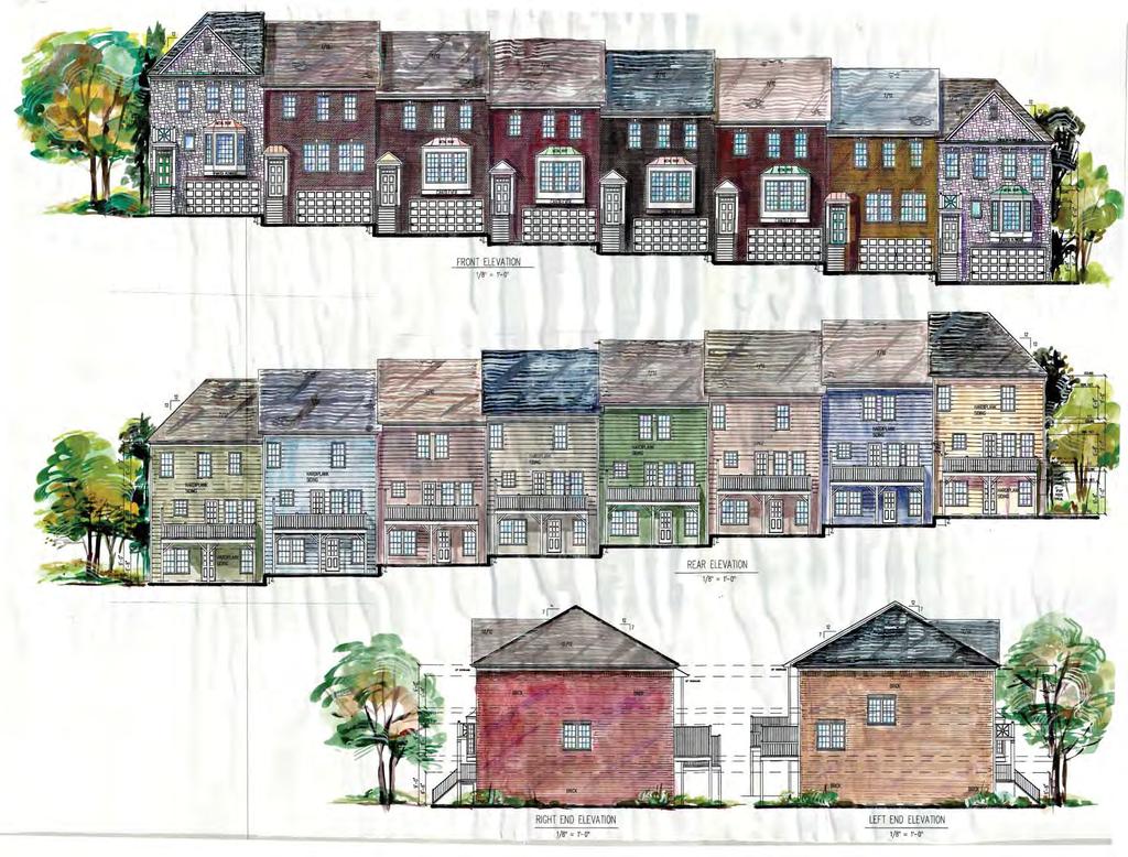
139
140 PL BUTTON GWINN ETT FULTON CIR BROOKLYN LN WILLIAMSBURG DR LINDSEY CT WILLIAMSBURG LN WYLMOOR WYLSTRE AM WYTOWER TRL JOHNSTON OAK LN HARBIN S COVE D R WINDEMERE OAK WAY CLOVERWOOD CT DICKENS RD DURH AM RIDGE DR DURHAM VIEW CT OLD TOWN PL ROCKBRIDGE WAY WALNUT CIR R OCKBR ID G E LN MAC DR FLO CIR PELTIER TRCE CURRANT TRL TUG DR JACKSON BANK PL WYMILL RD W YLA KE DR WALNUT CRE EK DR MAHOGANY CT NOELL WAY BASKETTE CT CANDLEWICK LN AR R OW IND RD PENROD PL HARBINS RD JAY WAY EMERALD CT R D WILLIA MS WISDOM CT BIG TREE CT CECIL CIR DANA DR KENNETH LN ALVIS LN DARRY CIR S WIND DR P OLIVER CT ICKWICK LN NATHA N DR INLAND WAY PEBBLE PEBBLE CREEK TRL CESAREA PL ROCKBRIDGE RD LILBURN BRADLEY WOODS CT BUCKSKIN CIR OMAH A D R ONETA DR WANDERING WAY C REE K DR DEER FIE LD LN RZM Printed: October 11, Feet RAMS CT ENGLE DR BELGRAVE LN JORDANAIRE PL GO BE R CANA OF GALILEE CT ANDOVE R WA Y RD LITTLE JOHN DR JORDAN DR SARDIS WAY MARIAN LN NOTTINGHAM DR JOHN CARROLL RD MA R TIN G ROVE DR LAWRENCEVILLE HWY ROCKBRIDGE CIR

141
142 ROCKBRIDGE RD RZM Printed: October 11, Feet
143 SUGAR CREEK CT WYMILL RD WYLAKE DR PELTIER TRCE TND CURRANT TRL TUG DR JACKSON BANK PL NOELL WAY BASKETTE CT FLO CIR ROCKBRIDGE RD WALNUT CREEK DR CECIL CIR ALVIS LN R75 S WIND DR THERRELL LN RM KENNETH LN DANA DR DARRY CIR DICKENS RD RZM Printed: October 11, Feet JORDAN DR CESAREA PL SHERIFF CT LITTLE JOHN DR FRIAR TUCK CT MARIAN LN LILBURN CB
144 GWINNETT COUNTY DEPARTMENT OF PLANNING AND DEVELOPMENT REZONING ANALYSIS CASE NUMBER :RZM ZONING CHANGE :C-2 & R-ZT TO R-TH LOCATION :3400 BLOCK OF SUGARLOAF PARKWAY MAP NUMBER :R & 013 ACREAGE :10.01 ACRES UNITS :60 UNITS PROPOSED DEVELOPMENT :TOWNHOMES COMMISSION DISTRICT :(4) HEARD FUTURE DEVELOPMENT MAP: EXISTING/EMERGING SUBURBAN APPLICANT: INLAND, LLC 2180 SATELLITE BOULEVARD SUITE DULUTH, GA CONTACT: ERIC JOHANSEN, RLA PHONE: OWNERS: GWINNETT COUNTY ABANDON PETS RESCUE 4155 LAWRENCEVILLE HIGHWAY, NE LILBURN, GA DWDW HOLDINGS, LLC 3454 SOUTH SCALES ROAD SUWANEE, GA DEPARTMENT RECOMMENDATION: DENIAL PROJECT DATA: The subject acre property is located on the west side of Sugarloaf Parkway north of its intersection with Five Forks Trickum Road. Two single family residences are currently located on the site, which the applicant intends to demolish. Two ponds and a creek are located at the rear of the subject property. The applicant is requesting rezoning from C-2 (General Business District) & R-ZT (Single Family Residence District) to R-TH for a 60-unit townhome development. The proposed gross and net density will be 5.9 units per acre as the property contains no flood hazard areas or easements. Stormwater detention is proposed to be located to the rear of the property. The submitted site plan indicates a 50-foot stream buffer and 75-foot impervious surface setback adjacent to the stream. Access to the site is proposed from a single entrance driveway along Sugarloaf Parkway.
145 RZM (AM) The applicant states that the minimum heated floor area will be 1,600 square feet. All units would have a two-car garage. According to the letter of intent, exterior facades would consist of a mixture of brick, stone, wood, fiber cement siding, stucco and EIFS (Exterior Insulation Finish System) accents. Site amenities proposed include a community green space and centrally located mail kiosk. ZONING HISTORY: In 1970, the subject property was zoned R-75 (Single Family Residence District). In 2006, the property was rezoned to C-2 and R-ZT, pursuant to RZC and RZR GROUNDWATER RECHARGE AREA: The subject property is not located within an identified Significant Groundwater Recharge Area. WETLANDS INVENTORY: The subject property contains areas, streams and/or bodies of water depicted as wetlands on the U.S. Department of Interior, Fish and Wildlife Service National Wetlands Inventory map on file with the Gwinnett Department of Planning and Development. The applicant/developer shall obtain all required approvals from the Gwinnett Department of Public Utilities and the U.S. Army Corps of Engineers for construction or land disturbance activities which may impact floodplain or wetland areas. OPEN SPACE AND GREENWAY MASTER PLAN: No comment. DEVELOPMENT REVIEW SECTION COMMENTS: The Buffer, Landscape and Tree Protection Section of the Unified Development Ordinance (Chapter 620) requires submittal and approval of a Tree Preservation and Replacement Plan prepared by a professional landscape architect prior to securing a Land Disturbance or Development permit. Section of the Unified Development Ordinance requires a 200-foot deceleration lane with a 50-foot taper at each project entrance that proposes access to a Minor Collection Street or Major Thoroughfare. Right-of-way dedication to accommodate the deceleration lane and an 11-foot shoulder is also required. Reduction in length of a deceleration lane requires approval of a Modification by the Development Division; elimination of a deceleration lane requires approval of a Waiver by the Board of Commissioners. Section of the Unified Development Ordinance requires construction of five-foot wide sidewalks along all exterior roadways adjoining the project, and four-foot wide sidewalks adjacent to both sides of all interior public streets (excluding cul-de-sac turnarounds).
146 RZM (AM) A 50-foot building and landscaped setback is required along exterior street frontage. (Unified Development Ordinance ). Provide a 40-foot natural, undisturbed buffer adjacent to R-140 residential zoned properties. (Unified Development Ordinance Chapter 610, Table and Section ). Section B of the Unified Development Ordinance requires an additional five-foot setback for all structures (parking lots, driveways, detention ponds, retaining walls, etc.) adjacent to required buffers. Section of the Unified Development Ordinance requires submittal of a Specimen Tree Concept Plan and Tree Survey prior to submittal and acceptance of a Development Permit Application. The developer must submit a concept plan for review and approval of the Development Division prior to submittal and acceptance of a development permit application. The developer must submit a preliminary plat (construction plans), including a grading plan, tree plan, and road/sewer profiles for review and approval of the Development Division prior to any construction. Section of the Unified Development Ordinance requires submittal of a Storm Water Management Report for the project prior to obtaining a Land Disturbance or Development Permit. Section A of the Unified Development Ordinance requires that the lowest floor, including the basement, of all residential building be constructed at an elevation of at least three feet above the 100-year floodplain. Note that all recreation areas, open space and/or common areas (including storm water detention facility lots) located within the development shall be controlled by a mandatory Property Owner s Association (to include reported bylaws) with responsibility for maintenance, insurance, and taxes for open space areas. The United States Postal Service may require a centralized mail delivery kiosk for this proposed development, replacing individual mail boxes. Mail delivery kiosk must be located outside of right-of-way access easement (if private street). Location and access must be approved by Gwinnett County D.O.T. STORMWATER REVIEW SECTION COMMENTS: This property appears to have stream buffers. All storm water best management practices will be applicable upon development permit issuance.
147 RZM (AM) GWINNETT COUNTY DEPARTMENT OF TRANSPORTATION COMMENTS: Sugarloaf Parkway is a Principal Arterial and 60 feet of right-of-way is required from the centerline, with 75 feet required within 500 feet of a major intersection. Standard deceleration lane with appropriate taper and adequate right-of-way will be required. Prior to the issuance of a Development Permit, a sight distance certification shall be provided. Minimum separation from a driveway, public road, or side street shall be provided as specified in the Gwinnett County Unified Development Ordinance. Private Street to meet public standards. There is a Gwinnett DOT project to install sidewalks on Sugarloaf Parkway, coordinate with GCDOT project management. GWINNETT COUNTY ENVIRONMENTAL HEALTH COMMENTS: No comment. GWINNETT COUNTY DEPARTMENT OF WATER RESOURCES COMMENTS: The available utility records show that the subject development is currently in the vicinity of a 12-inch water main located on the southwest right-of-way of Sugarloaf Parkway. Due to the uncontrollable variables, the Department of Water Resources makes no guarantees as to the minimum pressures or volumes available at a specific point within its system. Demands imposed by the proposed development may require reinforcements or extensions of existing water mains. Any cost associated with such required reinforcements or extensions will be the responsibility of the development and will not be provided by this department. The available utility records show that the subject development is currently in the vicinity of an eight-inch sanitary sewer main located approximately 201 feet southwest of parcel R on parcel R and an eight-inch sanitary sewer main located approximately 208 feet south of parcel R crossing the right-of-way of Sugarloaf Parkway. The subject development is located within the Yellow River service area. There are currently no connection restrictions within this service area. Treatment capacity within this area is presently available on a first come - first serve basis. Demands imposed by the proposed development may require reinforcements or extensions of existing sewer mains. Any cost associated with such required reinforcements or extensions will be the responsibility of the development and will not be provided by this department. Developer shall provide easements for future sewer connection to all locations designated by DWR during plan review.
148 RZM (AM) As-built information for this department is dependent upon outside entities to provide record drawings for the utilities. Therefore this department does not guarantee the accuracy of the information provided. Extensions of the water and/or sanitary sewer systems within the subject development must conform to this department s policies and Gwinnett County s ordinances. Proceeding design, construction, inspection, and final acceptance of the required utilities, service to these utilities would then become available under the applicable utility permit rate schedules. BUILDING CONSTRUCTION SECTION COMMENTS: No comment. GWINNETT COUNTY FIRE SERVICES COMMENTS: No comment. DEPARTMENT ANALYSIS: The subject property is located on the west side of Sugarloaf Parkway north of its intersection with Five Forks Trickum Road. The applicant is requesting rezoning from C-2 and R-ZT to R- TH for a 60-unit townhome development at a density of 5.9 units per acre. Two single family residences are currently located on the site, which the applicant intends to demolish. Two ponds and a creek are located at the rear of the subject property. The 2030 Unified Plan Future Development Map indicates the property is located within an Existing/Emerging Suburban Character Area. Policies for this Character Area encourage residential development at densities less than 3.0 units per acre and neighborhood commercial uses at appropriate intersections. Commercial development has been long established at this node centered on the intersection of Sugarloaf Parkway and Five Forks Trickum Road. Infill development of a commercial nature may be more consistent with recommendations of the 2030 Unified Plan for this area. This corridor is characterized by commercial retail uses and institutional uses that front Sugarloaf Parkway. This includes the Village Shoppes of Sugarloaf shopping center within the city limits of Lawrenceville to the south and a proposed grocery store adjacent to the North. To the east, across Sugarloaf Parkway is a school, Salvation Army, a church, daycare and RaceTrac gas station. Residential subdivisions are located behind these developments with a majority providing access off side streets. There are no townhomes in the vicinity and the proposed residential development with direct access to Sugarloaf Parkway would be out of character with the development pattern of the area. In conclusion, the introduction of a townhome development may not be compatible with the commercial nature of the immediate area and the surrounding residential properties per the
149 RZM (AM) policies of the 2030 Unified Plan. Therefore, the Department of Planning and Development recommends DENIAL.
150 RZM (AM) PLANNING AND DEVELOPMENT DEPARTMENT RECOMMENDED CONDITIONS NOTE: The following conditions are provided as a guide should the Board of Commissioners choose to approve the petition. Approval as R-TH for a townhouse development, subject to the following enumerated conditions: 1. To restrict the use of the property as follows: A. Attached townhouse dwellings and accessory uses not to exceed 60 units for a maximum density of 5.9 units per acre. B. Buildings shall be constructed of brick or stacked stone on four sides. Architectural elevations shall be submitted for review and approval by the Director of Planning and Development. C. The minimum heated floor area per dwelling unit shall be 1,800 square feet. D. All units shall have at least a double-car garage. All units shall provide sole access via alleys and shall have rear-entry garages except for units located along the periphery of the site, which may have street-facing garages. E. The Sugarloaf Parkway frontage and project entrance shall be landscaped by the developer and maintained by the Homeowner s Association. Entrance shall include a decorative masonry entrance feature. A solid brick wall or wrought iron fence with brick columns ever 30 feet shall be provided for the entire length of the frontage along Sugarloaf Parkway. Landscape, entrance feature, and fencing plans shall be subject to review and approval of the Director of Planning and Development. 2. To satisfy the following site development considerations: A. All grassed areas shall be sodded. B. All utilities shall be placed underground. C. Natural vegetation shall remain on the property until the issuance of a development permit. D. A pocket park shall be provided within the development to include, at a minimum size of approximately 3,500-square feet, a gazebo and permanent benches. Final layout and design shall be subject to the review and approval by the Director of Planning and Development.
151 RZM (AM) PLANNING AND DEVELOPMENT DEPARTMENT RECOMMENDATIONS STANDARDS GOVERNING EXERCISE OF THE ZONING SUITABILITY OF USE This townhome development may be out of character for the area as this corridor is developed with commercial uses directly abutting Sugarloaf Parkway and residential uses located to the rear. ADVERSE IMPACTS Potential adverse impacts on nearby commercial properties could be anticipated due to the introduction of an immediately adjacent residential use. REASONABLE ECONOMIC USE AS ZONED The property has a reasonable economic use as currently zoned. IMPACTS ON PUBLIC FACILITIES An increase in traffic, utilities usage, stormwater runoff, and the number of school-aged children could be anticipated from this request. CONFORMITY WITH POLICIES The 2030 Unified Plan Future Development Map indicates the property is located within an Existing/Emerging Suburban Character Area. Policies for this Character Area encourage residential development under 3.0 units per acre and neighborhood serving retail in appropriate locations. The introduction of townhomes in this heavily commercial location may not be consistent with these policies. CONDITIONS AFFECTING ZONING A townhome development with direct access to Sugarloaf Parkway may not be consistent with the development pattern of the area, in which no other residential development immediately abuts Sugarloaf Parkway.

152 Gwinnett County Planning Division Rezoning Application Last Updated 12/20 IS REZONING APPLICANT'S RESPONSE STANDARDS GOVERNING THE EXERCISE OF THE ZONING POWER PURSUANT TO REQUIREMENTS OF THE UNIFIED DEVELOPMENT ORDINANCE, THE BOARD OF COMMISSIONERS FINDS THAT THE FOLLOWING STANDARDS ARE RELEVANT IN BALANCING THE INTEREST IN PROMOTING THE PUBLIC HEALTH, SAFETY, MORALITY OR GENERAL WELFARE AGAINST THE RIGHT TO THE UNRESTRICTED USE OF PROPERTY AND SHALL GOVERN THE EXERCISE OF THE ZONING POWER. PLEASE RESPOND TO THE FOLLOWING STANDARDS IN THE SPACE PROVIDED OR USE AN ATTACHMENT AS NECESSARY: (A) WHETHER A PROPOSED REZONING WILL PERMIT A USE THAT IS SUITABLE IN VIEW OF THE USE AND DEVELOPMENT OF ADJACENT AND NEARBY PROPERTY: Yes, the proposed TH development will be compatible with the immediate and surrounding area. (B) WHETHER A PROPOSED REZONING WILL ADVERSELY AFFECT THE EXISTING USE OR USABILITY OF ADJACENT OR NEARBY PROPERTY: No, the proposed development will not adversely affect the existing use or usability of the adjacent and nearby properties. The surrounding area is a mixture of Commercial, Residential, and Office type uses. Immediately adjacent to the Subject Property is a Publix shopping center. (C) WHETHER THE PROPERTY TO BE AFFECTED BY A PROPOSED REZONING HAS REASONABLE ECONOMIC USE AS CURRENTLY ZONED: Yes, the Subject property as currently zoned C-2 and R-ZT does have a reasonable economic use, however, the shape of the land, the stream buffers and the steep topography make the property as currently zoned close to impossible to develop as these zoned uses. (D) WHETHER THE PROPOSED REZONING WILL RESULT IN A USE WHICH WILL OR COULD CAUSE AN EXCESSIVE OR BURDENSOME USE OF EXISTING STREETS, TRANSPORTATION FACILITIES, UTILITIES, OR SCHOOLS: No, the proposed development should not cause an excessive or burdensome use of the surrounding infrastructure. (E) WHETHER THE PROPOSED REZONING IS IN CONFORMITY WITH THE POLICY AND INTENT OF THE LAND USE PLAN: Yes, the proposed plan is in conformity with the policy and intent of the current Gwinnett County Land Use Plan. (F) WHETHER THERE ARE OTHER EXISTING OR CHANGING CONDITIONS AFFECTING THE USE AND DEVELOPMENT OF THE PROPERTY WHICH GIVE SUPPORTING GROUNDS FOR EITHER APPROVAL OR DISAPPROVAL OF THE PROPOSED REZONING: The property has steep topography and excessive stream buffers making the current zoning of C-2 and R-ZT close to impossible to develop considering the land cost and the development costs. The proposed solution of attached townhouses are a better for the land and its present challenges. ECEIVE Y 3 JCI 0 _ 2016 evelopment
153 October 5, 2016 Gwinnett County Board of Commissioners c/o Kathy Holland Director of Planning and Development 446 West Crogan Street Lawrenceville, GA Re: Sugarloaf Parkway Townhouse Development- Rezoning Letter of Intent Parcels: RS & R Gwinnett County, GA Dear Ms. Holland, Inland Group, LLC ("Inland") has been retained by Inland, LLC (the "Applicant") to pursue a Rezoning Application (the "Application") for real property located at the 3440 and 3460 Sugarloaf Parkway, Lawrenceville, GA and further described as Parcels R & R that are approximately ± acres (the "Subject Property"). The Applicant is Contract Purchaser of the Subject Property. The Subject Property is currently zoned C-2 (RZC } & R-ZT (RZR ) and is surrounded by a mixture of residential and commercial uses (to include small box retail, outparcel retail and retail shopping center uses) within the Sugarloaf Parkway corridor. The Applicant is proposing a Rezoning of the Subject Property to R-TH (Single Family Residential Townhouse District) for a residential development that will both compliment and blend into the immediate and surrounding area along the Sugarloaf Parkway corridor. Townhouses in this area provides an alternative residential living option for residents who want to be located near Highway 316 and Interstate 85 for commute purposes, the City of Lawrenceville and want their children to be educated within the Discovery School Cluster. The Sugarloaf Parkway corridor within the immediate vicinity of the Subject Property has an average daily traffic count of 36,200 ADT based on 2014 traffic data, with the workforce getting back into the daily grind, it is fair to assume this ADT will continue to increase annually. The Subject Property is surrounded by the following zoning designations with a Ji mile radius: C-1, C-2, 0-1, BG, HSB, R-ZT, RS-60, R-75 Mod, R-75, and RS-140. This Subject Property is clearly located within a transitional area from residential to commercial as evidenced by the vast zoning uses, and for the fact that a Publix anchored shopping center is immediately adjacent. The proposed R-TH development will include the construction of sixty (60) two-story single family townhouse units that are 24' wide by 50' deep, a minimum of 1,600 square feet in heated floor space, two car garages, covered front porches, and rear outdoor living areas. The proposed architecture will include a mixture of building -Zi~~ ' Satellite Boulevard I Suite I Duluth, Georgia (404) Phone (404) Fax C IVE BY UCT 0 01 l;=m in, & Development
154 21 P age materials to include brick, stone, wood, hardi cement siding, stucco and EIFS accents. The proposed development will include 4' sidewalks on both sides of the internal roads, community green space, centrally located mail kiosk, lush landscaping, stream buffer views, and on-site storm water management. We respectfully request your approval of this request for the Rezoning from C-2 and R-ZT to R-TH for the proposed single family residential town house development located on the Subject Property. The proposed use on the Subject Property is consistent with the current Unified Plan and creates an opportunity to provide an alternate housing option for residents of the Sugarloaf Parkway corridor. The residents of the proposed townhouse units will be Gwinnett County tax payers, and will continue to shop, eat, and support the local businesses of the surrounding area and local communities. We are available to meet with the County staff and District Representatives at any time to further discuss the merits of this Application upon request. Thank you for your consideration of this Application. Sincerely, ~ Eric Johansen, RLA Inland Group, LLC Agent for the Applicants cc: Applicant File \an.;vs' pment
155 Residential Rezoning Impact on Local Schools Prepared for Gwinnett County, November 2016 Proposed Zoning Case # Schools Current Projections Approximate additional Student Forecast Capacity Over/Under Forecast Capacity Over/Under Forecast Capacity Over/Under Projections from Proposed Developments RZM Meadowcreek HS ,850 1, ,850 1, ,850 1,382 3 Lilburn MS , , , Lilburn ES , , , RZM Discovery HS , , , Richards MS , , , Cedar Hill ES , , , RZM Mill Creek HS ,800 1, , , Osborne MS , , , Duncan Creek ES , , , RZR Lanier HS , , , Lanier MS , , , White Oak ES 801 1, , , RZR Grayson HS , , , Bay Creek MS , , , Trip ES 988 1, , , Current projections do not include new developments GCPS Planning Department /16/2016
156

157 Left Elevation rught Elevation Rear Elevation
158 5-79 TOWNE PARK DR SUGARLOAF PKWY KIRKLAND DR GAINSBOROUGH WAY FLAGLER CT CHERINGTON LN GR AYLAND GRAYLAND LN HILLS DR BLAZING RDG W BLAZING RDG STONE MILL RUN WILD WOOD LN LEIGH KAY DR ROSEMARY PL LAZY WILLOW LN TOWNE PARK CT 5-83 DUNHILL DR MARLTON CHASE DR FIRECREST LN DANIEL LN MILL RIDGE DR STONE R IDGE DR RIDGEMONT WAY RIDGEMONT DR SHADY VIEW PL VALLEY CLUB DR 5-78 PAULA CT LAWRENCEVILLE TOWN SQUARE CT 5-51 SPRING RD DOVE CREEK CIR PATTERSON RD DAIS Y MEADOW TRL JUNIOR TRL SENIOR DR GILPIN CT SOPHOMORE LN MAYBELL TRL CUM LAUDE WAY LONGMONT DR B R OOMFIELD WAY ACADEMIC CT FRESHMAN DR RACK RD SCHOLAR DR GAME TRL 5-84 SUGARLOAF PKWY SUMMERSTONE LN LIVERY CIR FIVE FORKS TRICKUM RD LAURELWOO D JOHNSON RD CT BELLBROOK LN BRIANTON LN BRIANTON CT SLETTEN DR COALVILLE DR TAKELY DR DRAYTON MANOR RUN BRIARHURST CT FLERY WAY VARSITY WAY 5-77 PL OLD SNELLVILLE HWY RIDGEWAY DR SOMERSET YANKTON DR EDGELEY WAY EDGELEY LN THORNCLIFF CT TANNERS POINT DR HERMAN TANNER 5-52 PLANTATION RD FAIRHAVEN CT RZM Printed: October 11, 2016 EXAM CT Feet TEXTBOOK CT INGLENOOK DR ASHTON LN STEEPLE CHASE DR TRO PHY TRL SILVA FOX CT STEEPLE CHASE DR 5-76 SOMERSET VALE CT VALE DR WILLISTON DR D OW NYSHIRE DR ALDERNEY BR 5-85 ALBEMARLE WAY FAIRINGTON PL DOWNYSHIRE CT
159 2180 Satellite Boulevard Suite Duluth, Georgia phone fax c Inland Group Copyright 2016 THIS DRAWING AND IT'S RESPECTIVE REPRODUCTIONS ARE THE PROPERTY OF INLAND GROUP, LLC (INLAND) AND MAY NOT BE REPRODUCED, PUBLISHED, OR USED IN WHOLE OR IN ANY PART WITHOUT THE EXPRESSED WRITTEN PERMISSION OF INLAND. THIS SEAL IS ONLY VALID IF COUNTER SIGNED AND DATED WITH AN ORIGINAL SIGNATURE PARCEL NUMBERS: R & R GWINNETT COUNTY, GEORGIA INLAND, LLC 2180 SATELLITE BOULEVARD SUITE DULUTH, GA (404) office (404) fax GSWCC LEVEL 11 CERTIFICATION # RZM Received Planning and Development REVISIONS: NUM 24 HOUR PROJECT CONTACT MR. CHAZ WATERS (404) cell TO LAWRENCEVILLE ** TRAFFIC COUNTS SITE DATA CHART PARCEL TAX IDENTIFICATION PARCELS R & R HIGHWAY 29 AREA OF PARCEL ± ACRES RL GA SU EXISTING ZONING OF PARCELS C-2 & R-ZT (SPLIT ZONING) AY KW AR FP OA RZC & RZR IC HI GH PA WAY ADDRESS OF PARCEL TTE SITE** RS RO SCEN ON AD KS OR EF FIV UM 3440 & 3460 SUGARLOAF PKWY, LAWRENCEVILLE, GA PROPOSED DEVELOPMENT PROPOSED UNIT DIMENSIONS PROPOSED UNIT STORIES ICK TR PROPOSED RESIDENTIAL DENSITY R-TH (SINGLE FAMILY TOWNHOUSE RESIDENCES) TOWNHOUSE UNITS (24' WIDE X 50'' DEEP) TWO STORIES WITH (2) CAR GARAGES 60 UNITS / ACRES = UNITS / ACRE TO SNELLVILLE ** P R O J E C T S I T E M A P (N T S) REVISION STREAM BUFFER AREA ±138,861 SF (±3.18 ACRES) THE AVERAGE DAILY TRAFFIC (ADT) FOR SUGARLOAF PARKWAY, BASED ON READILY AVAILABLE TRAFFIC DATA FROM THE GWINNETT COUNTY DEPARTMENT OF TRANSPORTATION WEBSITE IS AS FOLLOWS: 2014 ±36,223 ADT GENERAL NOTES 1. THE SUBJECT PROPERTY IS LOCATED ALONG THE SUGARLOAF PARKWAY (UNINCORPORATED GWINNETT COUNTY), AND MUST COMPLY WITH THE CURRENT DEVELOPMENT STANDARDS AND THE UNIFIED DEVELOPMENT ORDINANCE AT THE TIME OF LAND DISTURBANCE PERMITTING. 2. THE EXISTING INFORMATION USED FOR THE PREPARATION OF THIS CONCEPTUAL SITE PLAN WAS OBTAINED FROM LEGAL DESCRIPTIONS AND BOUNDARY SURVEYS OF THE SUBJECT PROPERTY PROVIDED BY THE PROPERTY OWNERS AND THEIR RESPECTIVE AGENTS, GWINNETT COUNTY GIS, AND READILY AVAILABLE AERIAL PHOTOGRAPHY. NO FIELD SURVEY DATA WAS USED, AND THE SUBJECT PROPERTY SHOULD BE SURVEYED BY A LICENSED SURVEYOR PRIOR TO DEVELOPMENT PERMITTING AND CONSTRUCTION ON THE SUBJECT PROPERTY. 3. ALL PROPOSED ITEMS DEPICTED ON THIS REZONING SITE PLAN ARE CONCEPTUAL IN NATURE AND ALL ITEMS MUST MEET THE CURRENT STANDARDS OF THE UNIFIED DEVELOPMENT ORDINANCE OF GWINNETT COUNTY AT THE TIME OF PERMITTING AND CONSTRUCTION. FLOODPLAIN NOTES ACCORDING TO FEMA FLOOD MAP PANEL 13135C0103F, EFFECTIVE DATE 09/26/2006, THERE IS NO FLOOD PLAIN ON THE SUBJECT PROPERTY FOR PARCELS AND SH E E T 1. THE PROPOSED COMMERCIAL DEVELOPMENT WILL BE CONNECTED TO GWINNETT COUNTY GRAVITY FLOW SANITARY SEWER 2. THE PROPOSED COMMERCIAL DEVELOPMENT WILL BE CONNECTED TO GWINNETT COUNTY WATER 3. THE PROPOSED COMMERCIAL DEVELOPMENT WILL HAVE ON-SITE DETENTION, WATER QUALITY, AND CHANNEL PROTECTION UTILIZING EITHER AN ABOVE GROUND FACILITY OR AN UNDERGROUND FACILITY, THIS HAS YET TO BE DETERMINED AT THIS POINT. T I T L E: REZONING SITE PLAN - 1 PROJECT UTILITIES 0 50 SCALE: DATE: PROJECT: " = 50' JULY 1, SHEET NUMBER 4. GAS, PHONE, ELECTRIC AND OTHER COMMON INFRASTRUCTURE WILL BE PROVIDED BY THE CARRIERS ESTABLISHED IN THE IMMEDIATE AND SURROUNDING AREA. MAGNETIC NOT RELEASED FOR CONSTRUCTION TO DULUTH ** DATE
160 SUGARLOAF PKWY SUGARLOAF PKWY GAME TRL RZM Printed: October 11, Feet
161 Cedar Hill ES Richards MS JOHNSON RD VALLEY CLUB DR R75MOD 5-83 R75 LAWRENCEVILLE RS150 AGNES CT 5-78 MAYBELL TRL OI DANIEL LN PAULA CT LONGMONT DR BROOMFIELD WAY R75CSO SUGARLOAF PKWY BG 5-84 SUGARLOAF PKWY C2 BG KENDALL PARK DR RZT SUMMERSTONE LN LIVERY CIR LIVERPOOL CT RS60 RACK RD RZT HSB R75 RS150 FIVE FORKS TRICKUM RD R CUM LAUDE WAY BN BG R75 GAME TRL TROPHY TRL RIDGEWAY DR SCHOLAR DR C1 VARSITY WAY FRESHMAN DR RZM Printed: October 11, 2016 GRADUATE DR Feet YANKTON DR 5-85 EDGELEY WAY RZT EDGELEY LN
162 GWINNETT COUNTY DEPARTMENT OF PLANNING AND DEVELOPMENT REZONING ANALYSIS CASE NUMBER :RZM ZONING CHANGE :C-2 & RA-200 TO R-TH LOCATION :4200 BLOCK OF BRASELTON HIGHWAY :4200 BLOCK OF SPOUT SPRINGS ROAD MAP NUMBERS :R , 051, 147, & 674 ACREAGE :32.13 ACRES UNITS :230 UNITS PROPOSED DEVELOPMENT :TOWNHOMES (BUFFER REDUCTION) COMMISSION DISTRICT :(3) HUNTER FUTURE DEVELOPMENT MAP: EXISTING/EMERGING SUBURBAN APPLICANT: MAHAFFEY, PICKENS, TUCKER, LLP 1500 N. BROWN ROAD, SUITE 125 LAWRENCEVILLE, GA CONTACT: SHANE LANHAM PHONE: OWNER: CONSTANCE FOSSETT TRONCALLI, MARTHA J STOVALL, CONNIE TRONCALLI, & HERITAGE LAND & DEVELOPMENT CO. C/O MAHAFFEY, PICKENS, TUCKER, LLP 1500 N. BROWN ROAD, SUITE 125 LAWRENCEVILLE, GA DEPARTMENT RECOMMENDATION: DENIAL PROJECT DATA: The applicant requests to rezone a acre parcel assemblage from RA-200 (Agriculture Residence District) and C-2 (General Business District) to R-TH (Residence Townhouse District). The subject property is located on the northern right-of-way of Braselton Highway, extending to the eastern right-of-way of Spouts Springs Road. The property abuts the southern right-of-way of I-85. Vehicular access to the development would be provided by a street connection onto Braselton Highway and Spout Springs Road. The proposed development would consist of 230 attached units on acres, which results in a gross and net density of 7.15 units per acre, as the property does not contain floodplain, power or gas easements. The submitted architectural elevations indicate the proposed townhouse buildings would be constructed with a combination of brick, cedar shake, stacked stone, fiber-cement siding. The proposed townhomes would be approximately 1,800 square feet each, with a front-entry two-car garage. Site amenities proposed include a clubhouse, pocket parks, swimming pool, tennis courts, and a parking area. Additionally, the site would
163 RZM (TH) consist of 7.9 acres of common area or approximately 25-percent of the total land area. The site also includes two proposed detention facilities, a pond, streams, and wetlands The standard external setbacks for R-TH zoning are 50 feet adjacent to both Braselton Highway and Spout Springs Road, while incorporating the required 50-foot landscape setback along all exterior street frontages. The required 40-foot side and rear setbacks are shown on the submitted site plan as well. The standard zoning buffer for R-TH is 40-feet when adjacent to properties zoned RA-200. As part of this request, the applicant is requesting to reduce the required zoning buffer to ten-feet. The applicant s submitted materials inaccurately delineate the required buffer as being 35 feet. ZONING HISTORY: In 1970, the property was zoned RA-200. A portion of the property has been zoned to C-2 since 2006, pursuant to RZC GROUNDWATER RECHARGE AREA: The subject property is not located within an identified Significant Groundwater Recharge Area. WETLANDS INVENTORY: The subject property does not contain areas, streams, and/or bodies of water depicted as wetlands on the U.S. Department of Interior, Fish, and Wildlife Service National Wetlands Inventory map on file with the Gwinnett Department of Planning and Development. OPEN SPACE AND GREENWAY MASTER PLAN: No comment. DEVELOPMENT REVIEW SECTION COMMENTS: The Buffer, Landscape and Tree Protection Section of the Unified Development Ordinance (Chapter 620) requires submittal and approval of a Tree Preservation and Replacement Plan prepared by a professional landscape architect prior to securing a Land Disturbance or Development permit. Section of the Unified Development Ordinance requires screening of dumpsters and loading/unloading facilities. Parking lots and interior driveways shall be designed in accordance with Chapter 240 of the Unified Development Ordinance. Section of the Unified Development Ordinance requires a 200-foot deceleration lane with a 50-foot taper at each project entrance that proposes access to a Minor Collection Street 2
164 RZM (TH) or Major Thoroughfare. Right-of-way dedication to accommodate the deceleration lane and an 11-foot shoulder is also required. Reduction in length of a deceleration lane requires approval of a Modification by the Development Division; elimination of a deceleration lane requires approval of a Waiver by the Board of Commissioners. Project access and required improvements along State routes or U.S. Highways (i.e., number and design of driveways, deceleration lanes, median breaks, etc.) will be subject to review and approval of the Georgia Department of Transportation. (Section F of the Unified Development Ordinance). Section of the Unified Development Ordinance requires construction of five-foot wide sidewalks along all exterior roadways adjoining the project, and four-foot wide sidewalks adjacent to both sides of all interior public streets (excluding cul-de-sac turnarounds). A 50-foot building and landscaped setback is required along the all exterior street frontages. (Unified Development Ordinance Section ). Provide a 35-foot natural, undisturbed buffer adjacent to RA-200 zoned properties. (Unified Development Ordinance Chapter 610, Table and Section ). Section B of the Unified Development Ordinance requires an additional five-foot setback for all structures (parking lots, driveways, detention ponds, retaining walls, etc.) adjacent to required buffers. Section of the Unified Development Ordinance requires submittal of a Specimen Tree Concept Plan and Tree Survey prior to submittal and acceptance of a Development Permit Application. The developer must submit a concept plan for review and approval of the Development Division prior to submittal and acceptance of a development permit application. The developer must submit a preliminary plat (construction plans), including a grading plan, tree plan, and road/sewer profiles for review and approval of the Development Division prior to any construction. Section of the Unified Development Ordinance requires submittal of a Storm Water Management Report for the project prior to obtaining a Land Disturbance or Development Permit. Section A of the Unified Development Ordinance requires that the lowest floor, including the basement, of all residential building be constructed at an elevation of at least three feet above the 100-year floodplain. Note that all recreation areas, open space and/or common areas (including storm water detention facility lots) located within the development shall be controlled by a mandatory 3
165 RZM (TH) Property Owner s Association (to include reported bylaws) with responsibility for maintenance, insurance, and taxes for open space areas. This project lies within an Activity Center/Corridor Overlay District, and is subject to all requirements set forth in Chapter 220 of the Unified Development Ordinance. The United States Postal Service may require a centralized mail delivery kiosk for this proposed development, replacing individual mail boxes. Mail delivery kiosk must be located outside of right-of-way access easement (if private street). Location and access must be approved by Gwinnett County D.O.T. STORMWATER REVIEW SECTION COMMENTS: This property appears to have stream buffers. All stormwater best management practices will be applicable upon development permit issuance. GWINNETT COUNTY DEPARTMENT OF TRANSPORTATION COMMENTS: Braselton Highway is a State Route and Georgia Department of Transportation right-of-way requirements govern. Spout Springs Road is a Major Collector and 40 feet of right-of-way is required from the centerline. A left turn lane shall be provided at the project entrance. Standard deceleration lane with appropriate taper and adequate right-of-way will be required. The project entrance shall align with opposing roads or driveways in accordance with the Gwinnett County Unified Development Ordinance. Prior to the issuance of a Development Permit, a sight distance certification shall be provided. The number and locations of driveways are subject to Gwinnett County D.O.T. approval. Minimum separation from a driveway, public road, or side street shall be provided as specified in the Gwinnett County Unified Development Ordinance. Project must comply with Gwinnett County D.O.T. Criteria and Guidelines for left turn lanes. Prior to the issuance of a Development Permit, the applicant shall provide a traffic impact study. Prior to the issuance of the first certificate of occupancy, the applicant shall make any improvements recommended by the traffic impact study, provided the improvements are 4
166 RZM (TH) approved by the D.O.T. All design and construction will be subject to D.O.T. review and approval. Provide a left turn lane on Spout Springs Road at development entrance meeting GCDOT standards. GWINNETT COUNTY ENVIRONMENTAL HEALTH COMMENTS: No comment. GWINNETT COUNTY DEPARTMENT OF WATER RESOURCES COMMENTS: The available utility records show that the subject development is currently in the vicinity of a 10-inch water main located on the southeast right-of-way of Braselton Highway and a 12-inch water main located on the southeast right-of-way of Spout Springs Road reducing to an eightinch water main. Due to the uncontrollable variables, the Department of Water Resources makes no guarantees as to the minimum pressures or volumes available at a specific point within its system. Demands imposed by the proposed development may require reinforcements or extensions of existing water mains. Any cost associated with such required reinforcements or extensions will be the responsibility of the development and will not be provided by this department. The available utility records show that the subject development is currently in the vicinity of an eight-inch sanitary sewer main located on parcel R The subject development is located within the Mulberry service area. There are currently no connection restrictions within this service area. Treatment capacity within this area is presently available on a first come - first serve basis. Demands imposed by the proposed development may require reinforcements or extensions of existing sewer mains. Any cost associated with such required reinforcements or extensions will be the responsibility of the development and will not be provided by this department. Developer shall provide easements for future sewer connection to all locations designated by DWR during plan review. As-built information for this department is dependent upon outside entities to provide record drawings for the utilities. Therefore this department does not guarantee the accuracy of the information provided. Extensions of the water and/or sanitary sewer systems within the subject development must conform to this department s policies and Gwinnett County s ordinances. Proceeding design, construction, inspection, and final acceptance of the required utilities, service to these utilities would then become available under the applicable utility permit rate schedules. 5
167 RZM (TH) BUILDING CONSTRUCTION SECTION COMMENTS: Building Plan Review has no objections under the following conditions: 1. The applicant shall obtain a residential building permit for each townhome and achieve satisfactory field inspections for issuance of a Certificate of Occupancy. For assistance, you may contact this office at Monday through Friday from the hours of 8:00 a.m. to 5:00 p.m. GWINNETT COUNTY FIRE SERVICES COMMENTS: No comment. DEPARTMENT ANALYSIS: The applicant is requesting rezoning on a acre parcel assemblage of land to R-TH for the construction of a 230-unit attached townhome development. The subject property is located along the right-of-ways of Braselton Highway and Spouts Springs Road, with frontage along I-85. The site currently consists of two single-family dwellings and related accessory structures. The 2030 Unified Plan Future Development Map indicates the property is located within an Existing/Emerging Suburban Character Area. Policies for this Character Area encourage singlefamily residential uses at a density of three units per acre or less. The requested R-TH at a density of 7.15 units per acre may be inconsistent with the policies 2030 Unified Plan. The surrounding area is primarily residential in character and includes single-family subdivision developments as well as residences on large acreage tracts. Adjacent to the south are larger lots zoned RA-200 with single-family dwellings. Adjacent to the east is the Millcrest Manor R- ZT zoned single-family detached subdivision, pursuant to RZR In addition, to the east a small tract of O-I (Office-Institutional District) was approved for a daycare (RZC ). Further to the east is Mill Creek High School and Osborne Middle School. To the south, across Braselton Highway are both developed and undeveloped properties zoned C-2 and homes on large tracts of land zoned RA-200, as well as several single-family residential developments. To the west, on both sides of Spouts Springs Road are homes on large tracts of land and undeveloped tracts of land zoned RA-200. To the north, across I-85 are several single-family developments zoned R-100, R-100 CSO, and R-75 CSO. The requested rezoning for a townhome development would be inconsistent with the established residential development pattern of the area and could set a precedent for future higher density requests. In conclusion, the requested R-TH zoning could be inconsistent with Board policy and the 2030 Unified Plan and zoning decisions in the immediate vicinity. Therefore, the Department of Planning and Development recommends DENIAL of this request. 6
168 RZM (TH) PLANNING AND DEVELOPMENT DEPARTMENT RECOMMENDED CONDITIONS NOTE: The following conditions are provided as a guide should the Board of Commissioners choose to approve the petition. Approval as R-TH for a townhome development, subject to the following enumerated conditions: 1. To restrict the use of the property as follows: A. Townhomes and accessory uses and structures. B. Dwellings shall be constructed of four sides brick, with minor treatments of stacked stone or fiber-cement siding/shake. Architectural elevations shall be submitted for review and approval by the Director of Planning and Development. C. The minimum heated floor area per dwelling unit shall be 2,000 square feet. D. All units shall have at least a double-car garage. All units shall provide sole access via alleys and shall have rear-entry garages except for units located along the periphery of the site, which may have street-facing garages. E. A mandatory homeowners association shall be incorporated which provides for building and grounds maintenance, repair, insurance and working capital. Said association must also include declarations and by laws including rules and regulations which shall at minimum regulate and control the following: i. Exterior home maintenance to include roofing and painting. ii. All grounds and common area maintenance, including the detention facilities. iii. Exterior fence maintenance to include the requirement that any graffiti shall be repaired and repainted within 72 hours. iv. Restrictions on single-family residential use only of units. No more than 10% of the total units may be leased by individual owners at any time. 2. To satisfy the following site development considerations: A. Provide a 40-foot landscaped strip along the right-of-ways of Braselton Highway, Spouts Springs Road and I-85, which shall include a decorative fence or wall and entrance monument. The fence may be constructed as solid brick wall, or as a wrought iron-style fence with brick columns (max. 30-feet-on-center). Landscaping, 7
169 RZM (TH) fence/wall and entrance monument design shall be subject to review and approval of the Director of Planning and Development prior to the issuance of a Development Permit. B. Provide a 40-foot wide natural, undisturbed buffer, supplemented with a solid opaque wood fence a minimum of six-feet in height, adjacent to all residentially zoned properties. The buffer shall be enhanced where sparsely vegetated to provide an effective visual screen. The Homeowner s Association shall ensure that buffer vegetation is not removed by individual unit owners. C. Natural vegetation shall remain on the property until issuance of a Development Permit. D. Direct unit access shall not be allowed to Braselton Highway, Spout Springs Road and I-85. E. All grassed areas within the development shall be sodded. F. All utilities shall be placed underground. 8
170 RZM (TH) PLANNING AND DEVELOPMENT DEPARTMENT RECOMMENDATIONS STANDARDS GOVERNING EXERCISE OF ZONING SUITABILITY OF USE In light of the low-density, detached residential developments and large lots that characterize the residential uses in the immediate area, an R-TH zoning and development may not be appropriate at this location. ADVERSE IMPACTS Adverse impacts on neighboring properties could be anticipated from the introduction of an incompatible zoning classification, density, and unit type. REASONABLE ECONOMIC USE AS ZONED The property may have a reasonable economic use as currently zoned. IMPACTS ON PUBLIC FACILITIES An increase in traffic, utilities usage, stormwater runoff, and the number of school-aged children could be anticipated from this request. CONFORMITY WITH POLICIES The 2030 Unified Plan Future Development Map indicates the property is located within the Existing/Emerging Suburban Character Area; the policies of the 2030 Unified Plan encourage consistency of both density and development type within a given area. The requested R-TH may be out of character with existing and proposed low-density single-family developments in the area. CONDITIONS AFFECTING ZONING This segment of the Braselton Highway corridor is predominately characterized by single-family uses and zoning further suggesting that a multi-family townhome R-TH zoning may be inappropriate for this location. 9
171 Gwinnett County Planning Division Rezoning Application Last Updated 2/20 14 REZONING APPLICANT'S RESPONSE STANDARDS GOVERNING THE EXERCISE OF THE ZONING POWER PURSUANT TO REQUIREMENTS OF THE UNIFIED DEVELOPMENT ORDINANCE, THE BOARD OF COMMISSIONERS FINDS THAT THE FOLLOWING STANDARDS ARE RELEVANT IN BALANCING THE INTEREST IN PROMOTING THE PUBLIC HEALTH, SAFETY, MORALITY OR GENERAL WELFARE AGAINST THE RIGHT TO THE UNRESTRICTED USE OF PROPERTY AND SHALL GOVERN THE EXERCISE OF THE Z ONING POWER. PLEASE RESPOND TO THE FOLLOWING STANDARDS IN THE SPACE PROVIDED OR USE AN ATTACHMENT AS NECESSARY: (A) WHETHER A PROPOSED REZONING WILL PERMIT A USE THAT IS SUITABLE IN VIEW OF THE USE AND DEVELOPMENT OF ADJACENT AND NEARBY PROPERTY: Please see attached (B) WHETHER A PROPOSED REZONING WILL ADVERSELY AFFECT THE EXISTING USE OR USABILITY OF ADJACENT OR NEARBY PROPERTY: Please see attached (C) WHETHER THE PROPERTY TO BE AFFECTED BY A PROPOSED REZ ONING HAS REASONABLE ECONOMIC USE AS CURRENTLY Z ONED: Please see attached (D) WHETHER THE PROPOSED REZONING WILL RESULT IN A USE WHICH WILL OR COULD CAUSE AN EXCESSIVE OR BURDENSOME USE OF EXISTING STREETS, TRANSPORTATION FACILITIES, UTILITIES, OR SCHOOLS: Please see attached (E) WHETHER THE PROPOSED REZONING IS IN CONFORMITY WITH THE POLICY AND INTENT OF THE LAND USE PLAN: Please see attached (F) WHETHER THERE ARE OTHER EXISTING OR CHANGING CONDITIONS AFFECTING THE USE AND DEVELOPMENT OF THE PROPERTY WHICH GIVE SUPPORTING GROUNDS FOR EITHER APPROVAL OR DISAPPROVAL OF THE PROPOSED REZONING: r~?ll Please see attached '1 t o o r 3 4 ~ "" ~...
172 REZONING APPLICANT'S RESPONSE STANDARDS GOVERNING THE EXERCISE OF THE ZONING POWER (A) (B) (C) (D) (E) (F) Yes, the proposed Rezoning Application will permit a use that is suitable in view of the use and development of adjacent and nearby property. The Property is adjacent to I-85 and is near land zoned C-2, 0-I, and C-1. No, the proposed Rezoning Application will not adversely affect the existing use or usability of any of the nearby properties. Due to the size, location, layout and dimensions of the subject property, the Applicant subn1its that the property does not have reasonable economic use as currently zoned. No, the proposed rezoning will not result in an excessive or burdensome use of the infrastructure systems. The Property has convenient access to Interstate 85 as well as frontage along both Spout Springs Road and Braselton Highway. Yes, the proposed Rezoning Application is in conformity with the policy and intent of the Gwinnett County Land Use Plan. The Property is designated as within the Existing/Emerging Character Area which encourages single-family townhouse develop1nents as well as Residential infill development. The Applicant submits that the subject Property's proximity to Interstate 85 and con1n1ercially-zoned property provides additional support of this Application. FZM '16 DO Q!. : c
173
174
175
176 Residential Rezoning Impact on Local Schools Prepared for Gwinnett County, November 2016 Proposed Zoning Case # Schools Current Projections Approximate additional Student Forecast Capacity Over/Under Forecast Capacity Over/Under Forecast Capacity Over/Under Projections from Proposed Developments RZM Meadowcreek HS ,850 1, ,850 1, ,850 1,382 3 Lilburn MS , , , Lilburn ES , , , RZM Discovery HS , , , Richards MS , , , Cedar Hill ES , , , RZM Mill Creek HS ,800 1, , , Osborne MS , , , Duncan Creek ES , , , RZR Lanier HS , , , Lanier MS , , , White Oak ES 801 1, , , RZR Grayson HS , , , Bay Creek MS , , , Trip ES 988 1, , , Current projections do not include new developments GCPS Planning Department /16/2016
177
178

179
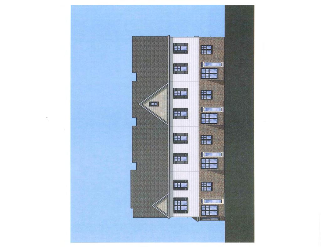
180
181
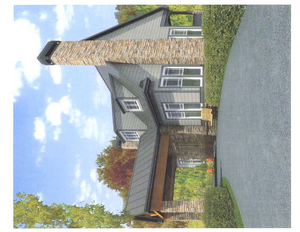
182
183 MINERAL SPRINGS RD SARDIS CHURCH RD HAMILTON PA RC LN DUNCAN BRIDGE DR SARDIS MILL TRL DUNCAN BRIDG E TRL 3-7 SHAY TER BRAN DON ACRES DR SPOUT SPRINGS RD OAKPOINTE CT DOC HUGHES RD SPRING SOUND LN SHAY CT DUNCANS SHORE DR OLD FLOWERY BRANCH RD APPLE GROVE RD APPLE GROVE BARBERRY DR R D 1-2 SPRING STONE CT WELL SP RINGS DR LAKE COVE CT MILL FARM LN WATER MILL DR TULIP PETAL RD L ILY STEM TRL LIL Y STEM DR FLOWERY BRANCH RD 1-1 ROVE LLO WAY I85N LATVIA LN I85S MILFORD QUAIL POINT RUN WHEELE R CREEK DR PL E ROCK QUARRY RD 3-3 WATLEY PL BO N D ST WAY BRASELTON HWY GABLES PL DARTFORD WA Y KIN G S CROS S 3-2 FOX RIDGE DR MULBERRY RIDGE LN HOG MOUNTAIN RD HOLMAN RD RZM LANTERN HILL DR PINE RD PATRICK RD Printed: October 11, Feet GREEN HUN TINGTON HILL TRCE G ABLES TRCE MARK TODD CT HAMPTON WALK DR EVAN CT SMOKE HILL DR
 '-...--- 1. SPEED LMT CF BRABELTOI HWY t8-46 MPH IHl n SPEED LMT OF SPOUT 8PRINQ8 ROAD 18..0 MPH. 2. ACCORDINQ TO A I!TUOY BY CXlRBLU ECCJl.")
184 ~ ~.:ITE.) N6s::~o sg r s2.!j' GEORO~l ' RIW ~- 1' ~ - ~ LOCATION MAP -,.-- /"~'!.!!:!'/~~- / Town~lac Tawn~I.ac. \ -ESP- / -~ ' / 11~,~ / /, /.. ~- / >=/, /.././ / :-,~..: <WET1N<DAAEA2./--.>;~ '-...,/// ) ' SPEED LMT CF BRABELTOI HWY t8-46 MPH IHl n SPEED LMT OF SPOUT 8PRINQ8 ROAD MPH. 2. ACCORDINQ TO A I!TUOY BY CXlRBLU ECCJl.OOY CR1IP-ViE'TlNil!l ARE LOCAlED ON THIS SITE NfD ARE mentlaed ON n P'l..NI. 1 ACCOfi)INO TO TME FB&A fux)q IHSURANCE RATE W.O FCR G'NINNETTCOlfiTY,OE<RJA.-.ND.. ~lcdaaem., ="='"NOT~~~~~=~~A~ ~~~~~~NOT'MTHIN2XJ'OFTHI8PfWJPERTY. ~~:rrahooq E RNER IS NOTWJTHIN:DD'CFliGS a. CJoNN TT COUNTY FIRE DEPNnloiENT SHAU.NIPRCNE ROAD LAYOUTNifJEN'JRNoiCEa. 7. WA'TERSEfMCE SHAU. BE PROVIDED BY OWINETT C:CUrm'. ~~~~==: ll1lim!rnoiii: 1...UICIJNDirAYNm11JIIIO~YIMTMBI,_.,.~CD.II'TYGZSNEI JIW'SMDDeDia.T"AIM:DI'9Dt1li!!QIIfiiiii!ITCD.II'TYTAX~CI'P.IZ. OWNERJDI!VELOPER ROCKL YN HOMES, INC. 357SKD3ERBLVD. 8UrTE:ZOO 24 HOUR CONTACT TIMJENt<lNS T~~YN~ ~7 Parle Drive,. Suite 400 Nor=ou,. Georgia~ Phone: (770)C&-7511 Pax: (770)C :i?f "JJ'.frw 70..JS S70'<~ J'o <~"w 9J.6J' BRASELTON IDOHWAY- OA l2a SO'RIW c:'i7~,j1,,t.m H l 6 10 u"".' s -~...,. lll&ucy~?~ ~ j.? io Q CRAPHIC~~L( - 1~ 2 r~el tso SITE DATA: BfTENEA 32.13~ NET 8JTE. AR A ACH:8 NErDENSITY 7.15UIA TOTAI..UNITS 230 OPEN8P.ACE 7.Jb~C(:l4%} FUXDPLAIN(APPROXIMATE) 0 ZONING EJQSTJN(l2CN1HQ_ PROPOSEDlOI'"NO 2011HQJURSSOICTION DIM!LOP>Il!NI'T!PI! FRONT EHTRYTOYiNS _ ~~ARKNl(3PERIHl) CONCEPT PLAN Spout Springs Road Tract P!Nf ,051,136, 147 BnuoltlnHwy, GYMnot!C<ulty,Goar!la :A": I ~:~, C:ZORA200 - R-nt CJW\NoiETTCOUNTY 1 of II ',
185 DOC HUGHES RD I85N LATVIA LN I85S SPOUT SPRINGS RD MILLCREST DR BRASELTON HWY RZM Printed: October 11, Feet HOLMAN RD
186 1-2 R100 RA200 RA R100 R100CSO MILL FARM LN R75CSO WATER MILL DR DOC HUGHES RD Mill Creek HS R75MOD I85S SPOUT SPRINGS RD RZT 3-3 I85N C2 MILLCREST DR OI C1 BRASELTON HWY RA200 MILFORD PL C2 HOLMAN RD WATLEY PL R RZM MINERAL SPRINGS RD R100 DARTFORD WAY R100 Printed: October 11, 2016 GABLES PL Feet
187 GWINNETT COUNTY DEPARTMENT OF PLANNING AND DEVELOPMENT REZONING ANALYSIS CASE NUMBER :RZR ZONING CHANGE :R-100 TO R-75 LOCATION :2000 BLOCK OF BUFORD DAM ROAD MAP NUMBERS :R ACREAGE :20.27 ACRE UNITS :38 UNITS PROPOSED DEVELOPMENT :SINGLE-FAMILY SUBDIVISION COMMISSION DISTRICT :(4) HEARD FUTURE DEVELOPMENT MAP: EXISTING/EMERGING SUBURBAN APPLICANT: WHITE HORSE 70, LLC C/O MILL CREEK CONSULTING 4480 COMMERCE DRIVE, SUITE A BUFORD, GA CONTACT: MITCH PEEVY PHONE: OWNER: BARBARA I. BRADBERRY C/O MILL CREEK CONSULTING 4480 COMMERCE DRIVE, SUITE A BUFORD, GA DEPARTMENT RECOMMENDATION: APPROVAL WITH CONDITIONS PROJECT DATA: The applicant requests the rezoning of a acre parcel from R-100 (Single-family Residence District) to R-75 (Single-family Residence District) to construct a 38-lot single-family subdivision. The subject property is located on the south side of Buford Dam Road, east of Jimmy Dodd Road. The property presently contains a single-family residence and the remainder of the property is heavily wooded. The property is surrounded on three sides by residential developments within the city limits of Buford. The submitted site plan shows 38 lots on a net acreage of acres, due to 6,970 square feet (0.16-acre) of flood area, resulting in a density of units per acre. The development would be accessed by a single entrance/exit onto Buford Dam Road. Staff notes that there are two detention ponds proposed to address site drainage. Additionally, there is a 60 foot wide Department of Water Resources easement that cuts through the property, and multiple streams identified on the site plan. The minimum lot size for the proposed lots is 10,500 square feet, with a 2,700 square foot minimum dwelling size for each detached residences. The front facades of the homes would be constructed of brick or stone accents with the balance of
188 RZR (AH) the homes being the same, cedar shake or fiber cement siding. The letter of intent proposes 4.55-acres of open space that will be dedicated to the mandatory Home Owners Association. ZONING HISTORY: The subject property has been zoned R-100 since GROUNDWATER RECHARGE AREA: The subject property is not located within an identified Significant Groundwater Recharge Area. WETLANDS INVENTORY: The subject property contains areas, streams and/or bodies or water depicted as wetlands on the U.S. Department of Interior, Fish and Wildlife Service National Wetlands Inventory map on file with the Gwinnett Department of Planning and Development. The applicant/developer shall obtain all required approvals from the Gwinnett Department of Public Utilities and the U.S. Army Corps of Engineers for construction or land disturbance activities which may impact floodplain or wetland areas. OPEN SPACE AND GREENWAY MASTER PLAN: No comment. DEVELOPMENT REVIEW SECTION COMMENTS: The Buffer, Landscape and Tree Protection Section of the Unified Development Ordinance (Chapter 620) requires submittal and approval of a Tree Preservation and Replacement Plan prepared by a professional landscape architect prior to securing a Land Disturbance or Development permit. Parking lots and interior driveways shall be designed in accordance with Chapter 240 of the Unified Development Ordinance. Section of the Unified Development Ordinance requires a 200-foot deceleration lane with a 50-foot taper at each project entrance that proposes access to a Minor Collection Street or Major Thoroughfare. Right-of-way dedication to accommodate the deceleration lane and an 11-foot shoulder is also required. Reduction in length of a deceleration lane requires approval of a Modification by the Development Division; elimination of a deceleration lane requires approval of a Waiver by the Board of Commissioners. Section of the Unified Development Ordinance requires construction of five-foot wide sidewalks along all exterior roadways adjoining the project, and four-foot wide sidewalks adjacent to both sides of all interior public streets (excluding cul-de-sac turnarounds).
189 RZR (AH) Section of the Unified Development Ordinance requires submittal of a Specimen Tree Concept Plan and Tree Survey prior to submittal and acceptance of a Development Permit Application. The developer must submit a preliminary plat (construction plans), including a grading plan, tree plan, and road/sewer profiles for review and approval of the Development Division prior to any construction. The developer must obtain a Land Disturbance or Development Permit from the Development Division prior to any construction. Section of the Unified Development Ordinance requires submittal of a Storm Water Management Report for the project prior to obtaining a Land Disturbance or Development Permit. Section A of the Unified Development Ordinance requires that the lowest floor, including the basement, of all residential building be constructed at an elevation of at least three feet above the 100-year floodplain. Note that all recreation areas, open space and/or common areas (including storm water detention facility lots) located within the development shall be controlled by a mandatory Property Owner s Association (to include reported bylaws) with responsibility for maintenance, insurance, and taxes for open space areas. The United States Postal Service may require a centralized mail delivery kiosk for this proposed development, replacing individual mail boxes. Mail delivery kiosk must be located outside of right-of-way access easement (if private street). Location and access must be approved by Gwinnett County D.O.T. STORMWATER REVIEW SECTION COMMENTS: No comment. GWINNETT COUNTY DEPARTMENT OF TRANSPORTATION COMMENTS: Buford Dam Road is a Minor Arterial and 40 feet of right-of-way is required from the centerline, with 50 feet required within 500 feet of a major intersection. Standard deceleration lane with appropriate taper and adequate right-of-way will be required. The project entrance shall align with opposing roads or driveways in accordance with the Gwinnett County Unified Development Ordinance. Prior to the issuance of a Development Permit, a sight distance certification shall be provided.
190 RZR (AH) Minimum separation from a driveway, public road, or side street shall be provided as specified in the Gwinnett County Unified Development Ordinance. Project must comply with Gwinnett County D.O.T. Criteria and Guidelines for left turn lanes. GWINNETT COUNTY ENVIRONMENTAL HEALTH COMMENTS: No comment. GWINNETT COUNTY DEPARTMENT OF WATER RESOURCES COMMENTS: The available utility records show that the subject development is currently in the vicinity of a 12-inch water main located on the northeast right-of-way of Buford Dam Road. Due to the uncontrollable variables, the Department of Water Resources makes no guarantees as to the minimum pressures or volumes available at a specific point within its system. Demands imposed by the proposed development may require reinforcements or extensions of existing water mains. Any cost associated with such required reinforcements or extensions will be the responsibility of the development and will not be provided by this department. The available utility records show that the subject development is currently in the vicinity of an eight-inch sanitary sewer main located approximately 152 feet south of parcel R on the right-of-way of Dexters Mill Place. The subject development is located within the Level Creek service area. There are currently no connection restrictions within this service area. Treatment capacity within this area is presently available on a first come - first serve basis. Demands imposed by the proposed development may require reinforcements or extensions of existing sewer mains. Any cost associated with such required reinforcements or extensions will be the responsibility of the development and will not be provided by this department. Developer shall provide easements for future sewer connection to all locations designated by DWR during plan review. As-built information for this department is dependent upon outside entities to provide record drawings for the utilities. Therefore this department does not guarantee the accuracy of the information provided. Extensions of the water and/or sanitary sewer systems within the subject development must conform to this department s policies and Gwinnett County s ordinances. Proceeding design, construction, inspection, and final acceptance of the required utilities, service to these utilities would then become available under the applicable utility permit rate schedules. The developer shall maintain the existing grade and cover in the 60 foot easement.
191 RZR (AH) BUILDING CONSTRUCTION SECTION COMMENTS: No comment. GWINNETT COUNTY FIRE SERVICES COMMENTS: No comment. DEPARTMENT ANALYSIS: The subject property is located on the south side of Buford Dam Road, east of its intersection with Jimmy Dodd Road. It is presently zoned R-100 and contains one single-family residence. The majority of the property is heavily wooded. The 2030 Unified Plan Future Development Map indicates that the property is located within an Existing/Emerging Suburban Character Area. This Character Area encourages single-family subdivisions at low to moderate densities, and recommends that infill developments be consistent with the character of existing abutting development. Surrounding properties in the area are majority single-family detached dwellings on a variety of property sizes. At the proposed density of 1.88 units per acre, the requested R-75 development may be consistent with policies and recommendations of the 2030 Unified Plan. The surrounding area is characterized by single-family subdivisions and single-family dwellings on acreage tracts. To the south is the Little Mill Farm subdivision that is zoned R-100MOD (Modified Single-family development) pursuant to SUP , which has similar density to the proposed project. As noted, the properties to the west, north and east are within the city limits of Buford, but maps indicate that the surrounding neighborhoods are developed with similarly sized properties and single-family residences. On the north side of Buford Dam Road east of the subject parcel are several neighborhoods that are zoned RL (Lakeside Residence District) and are developed with single-family residences whose development standards appear to be comparable to the proposed development. The proposed R-75 district could be consistent with the development pattern of the area. In conclusion, the proposed R-75 zoning and lot sizes may be considered consistent with the zoning and development pattern in the area, and with the recommendations of the 2030 Unified Plan. The request could result in a compatible single-family development with implementation of staff s recommended conditions. Therefore, the Department of Planning and Development recommends APPROVAL WITH CONDITIONS of this request.
192 RZR (AH) PLANNING AND DEVELOPMENT DEPARTMENT RECOMMENDED CONDITIONS Approval as R-75 for a Single-family Subdivision, subject to the following enumerated conditions: 1. To restrict the use of the property as follows: A. Single-family residential and accessory uses and structures. B. The maximum number of lots shall be 38. No lots shall be allowed within the existing 60 foot water easement. C. Only the access roadway shall be allowed to cross perpendicular within the existing water easement and within any stream buffers subject to the review and approval of the Department of Water Resources. D. The minimum heated floor area per dwelling shall be 2,700 square feet. E. Homes shall be constructed with front facades and sides of brick and/or stacked stone. The rear of the homes may be the same, cedar plank or fiber-cement siding with a minimum three-foot brick or stacked stone water table. F. All dwellings shall have at least a double-car garage. 2. To satisfy the following site development considerations: A. Natural vegetation shall remain on the property until the issuance of a development permit. B. No direct lot access shall be allowed to Buford Dam Road. C. The Buford Dam Road frontage shall be landscaped and maintained by the Homeowner s Association, and shall include a landscaped entrance feature, a decorative wrought iron fence with brick columns spaced 30 feet on center and landscaping along the entire frontage. Landscaping, fencing and monument signage plans shall be subject to review and approval of the Director of Planning and Development. D. All grassed areas on dwelling lots shall be sodded. E. Underground utilities shall be provided throughout the development. F. The detention pond(s) shall be screened from all residential properties.
193 RZR (AH) PLANNING AND DEVELOPMENT DEPARTMENT RECOMMENDATIONS STANDARDS GOVERNING EXERCISE OF THE ZONING SUITABILITY OF USE In view of the surrounding residential developments constructed or approved for similar densities, the proposed single-family subdivision could be suitable for this location. ADVERSE IMPACTS No adverse impacts would be anticipated as the proposed development is similar to those established in the immediate area. REASONABLE ECONOMIC USE AS ZONED The property has a reasonable economic use as currently zoned. IMPACTS ON PUBLIC FACILITIES An increase in traffic, utilities usage, stormwater runoff, and the number of school-aged children could be anticipated from this request. CONFORMITY WITH POLICIES The 2030 Unified Plan Future Development Map indicates the property is located within the Existing/Emerging Suburban Character Area. The proposed development could be considered consistent with policies recommending infill development be compatible with the surrounding development pattern. CONDITIONS AFFECTING ZONING This portion of the Buford Dam Road corridor is characterized as a mix of low density housing products. The proposed development could be consistent with the surrounding area.

194 A -1 1 ACHMENT SA PAGE2 REVISED 07/91 STANDARDS GOVERNING EXERCISE OF THE ZONING POWER PURSUANT TO SECTION 1702 OF THE 1985 ZONING RESOLUTION, THE BOARD OF COMMISSIONERS FINDS THAT THE FOLLOWING STANDARDS ARE RELEVANT IN BALANCING THE INTEREST IN PROMOTING THE PUBLIC HEALTH, SAFETY, MORALITY, OR GENERAL WELFARE AGAINST THE RIGHT TO THE UNRESTRICTED USE OF PROPERTY AND SHALL GOVERN THE EXERCISE OF THE ZONING POWER. PLEASE RESPOND TO THE FOLLOWING STANDARDS IN THE SPACE PROVIDED OR USE AN ATTACHMENT AS NECESSARY: (A) WHETHER A PROPOSED REZONING WILL PERMIT A USE THAT IS SUITABLE IN VIEW OF THE USE AND DEVELOPMENT OF ADJACENT AND NEARBY PROPERTY: THE APPLICANT BELIEVES THE PROPOSED USE IS SUITABLE. (B) WHETHER A PROPOSED REZONING WILL ADVERSELY AFFECT THE EXISTING USE OR USABILITY OF ADJACENT OR NEARBY PROPERTY: THE PROPOSED USE WILL NOT ADVERSELY AFFECT THE USE OF THE SURROUNDING PROPERTIES. (C) WHETHER THE PROPERTY TO BE AFFECTED BY A PROPOSED REZONING HAS A REASONABLE ECONOMIC USE AS CURRENTLY ZONED: THE APPLICANT BELIEVES THAT THE SUBJECT PROPERTY DOES NOT HAVE A REASONABLE ECONOMIC USE AS CURRENTLY ZONED. (D) WHETHER THE PROPOSED REZONING WILL RESULT IN A USE WHICH WILL OR COULD CAUSE AN EXCESSIVE OR BURDENSOME USE OF EXISTING STREET, TRANSPORTATION FACILITIES, UTILITIES OR SCHOOLS: THE PROPOSED USE WILL NOT PRODUCE AN ADVERSE AFFECT ON THE EXISTING INFRASTRUCTURE. (E) WHETHER THE PROPOSED REZONING IS IN CONFORMITY WITH THE POLICY AND INTENT OF THE LAND USE PLAN: THE SUBJECT PROPERTY IS DESIGNATED AS CHATTAHOOCHEE RIVER AREA (F) WHETHER THERE ARE OTHER EXISTING OR CHANGING CONDITIONS AFFECTING THE USE AND DEVELOPMENT OF THE PROPERTY WHICH GIVE SUPPORTING GROUNDS FOR EITHER APPROVAL OR DISAPPROVAL OF THE PROPOSED REZONING: SEE LETTER OF INTENT. RECEIVED BY SEP Planning & Development
195 ATTACHMENT 5A PAGE3 REVISED 07/91 Based upon the above reasons, the applicant feels that this is a reasonable request and that action contradictory to the zoning request will constitute a taking of property in violation of the Just Compensation Clause of the Fifth Amendment and the Due Process Clause of the Fourteenth Amendment to the Constitution of the United States, and Article P, Section 1, Paragraph 1, and Article 1, Section 3, Paragraph 1 of the Constitution of Georgia, denying the owner viable use of its land. PLANNING DIVISION USE ONLY CASE NUMBER RECEIVED BY: R CE\VED BY SEP z.r '16 2 P\ann\ng & Oeve\opment
196 REZONING APPLICANT'S LETTER OF INTENT The Applicant, White Horse 70, LLC, requests rezoning on acres for the purpose of developing a Single Family detached subdivision. In order to develop the site as proposed, the Applicant respectfully requests a rezoning from R-1 00 to R-75. The subject property is located at 2053 Buford Dam Road and is found in the 7th district, land lot 334 in Gwinnett County. The enclosed site plan indicates 38 units on the subject site. The site plan shows that the project will have one entrance onto Buford Dam Road. The minimum heated square footage for the dwellings will be 2, 700 sf for all the homes with a maximum height for the proposed dwellings 35'. The exterior of all dwellings will consist of brick or stone accents on the front fac;ade. The balance of the home may be the same or wood, cedar shake or fiber cement siding. Price range for the units will be from the mid $300s and up. Sidewalks will be provided on the interior streets and along the entire frontage along Buford Dam Road. The 2 subdivisions that adjoin this property along the sides are in the City of Buford and are on septic tank lots. The subdivision to the rear, Little Mill Farms, is in the county and it is connected to sanitary sewer and has lots exactly the same size as the applicant is proposing. While there is no open space required, the applicant is proposing to provide 4.55 acres or 22% of the property as common open space. The open space will be dedicated to the mandatory Home Owners Association for maintenance and use by all the residents. R CEIVED 8 SEP Planning & Development RZR '
197 Residential Rezoning Impact on Local Schools Prepared for Gwinnett County, November 2016 Proposed Zoning Case # Schools Current Projections Approximate additional Student Forecast Capacity Over/Under Forecast Capacity Over/Under Forecast Capacity Over/Under Projections from Proposed Developments RZM Meadowcreek HS ,850 1, ,850 1, ,850 1,382 3 Lilburn MS , , , Lilburn ES , , , RZM Discovery HS , , , Richards MS , , , Cedar Hill ES , , , RZM Mill Creek HS ,800 1, , , Osborne MS , , , Duncan Creek ES , , , RZR Lanier HS , , , Lanier MS , , , White Oak ES 801 1, , , RZR Grayson HS , , , Bay Creek MS , , , Trip ES 988 1, , , Current projections do not include new developments GCPS Planning Department /16/2016
198 7-362 BUFORD DAM RD BRANDEN HILL LN LAKEVIEW DR WOODLAKE DO GWO OD CIR DR DOLVIN LN LANIER H EIGHTS CIR MATHIAS WAY SAINT MILES DR SHADBURN AMBERCREST CT MARINA WAY ELM TR EE DR LAKE LANIER HEIGHTS RD LAKE WINDSOR PKWY SAINT KENNEDY LN FERRY RD STEWART RD JIMMY DODD RD CRE ST HILL DR QUEENSBORO LN HALL E L M TRE E TER COINSBOROUGH WAY AMBERCREST PL COLE RD ANCHOR WAY BUFORD MAPLE CREEK DR BURR CT HARBOR DR DEXTERS MILL WIND LASS GRINDSTONE DR DR SHIPWRECK ST PL PATRICK MILL PL LITTLE MILL PKWY POST MILL CT PORT DR MINA LANE DR LEAF RIDGE LN SHOAL CREEK RD COLE RD RZR SUGAR HILL Printed: October 11, Feet LITTLE MILL RD SKYLAR S KYLAR HILL DR LE GRI GGS CT IGH DR COPPER GROVE LN SKYLAR CREEK LN PEACHTREE INDUSTRIAL BLVD

199 fu 0 LU > UJ u UJ cr
200 BUFORD DAM RD JIMMY DODD RD ANCHOR WAY HARBOR DR SHIPWRECK ST STARBOARD CT MAPLE CREEK DR MAPLE WOOD TRL DEXTERS MILL PL LITTLE MILL PKWY RZR Printed: October 11, Feet
201 7-352 MARINA WAY R100MOD R100 R100 JIMMY DODD RD RA100 ELM TREE TER HARBOR DR ELM TREE DR R100 RL BUFORD DAM RD DOLVIN LN R100 P C2 OI ANCHOR WAY R100CSO R100 PORT DR R100C MAPLE CREEK DR SHIPWRECK ST P BUFORD DEXTERS MILL PL LITTLE MILL PKWY R100 RZR Printed: October 11, Feet WIND LASS DR R100MOD PATRICK MILL PL POST MILL CT HOPPER DR LITTLE MILL RD R100MOD
202 GWINNETT COUNTY DEPARTMENT OF PLANNING AND DEVELOPMENT REZONING ANALYSIS CASE NUMBER :RZR ZONING CHANGE :R-100 TO RA-200 LOCATION :3800 BLOCK OF STEPHENS ROAD MAP NUMBER :R ACREAGE :8.56 ACRES UNITS :1 UNIT PROPOSED DEVELOPMENT :FARMER S MARKET (ON-SITE PRODUCTS ONLY) COMMISSION DISTRICT :(3) HUNTER FUTURE DEVELOPMENT MAP: RURAL/ESTATE APPLICANT: ANN LANGLEY 1936 LAKE LUCERNE ROAD LILBURN, GA CONTACT: ANN LANGLEY PHONE: OWNER: JAMES E. FUTRAL 3809 STEPHENS ROAD LOGANVILLE, GA DEPARTMENT RECOMMENDATION: APPROVAL WITH CONDITIONS PROJECT DATA: The applicant requests rezoning of an 8.56 acre property from R-100 (Single Family Residence District) to RA-200 (Agriculture Residence District) for an on-site farmers market. The subject property is located on the southwestern side of Stephens Road, north of its intersection of Old Loganville Road. The property is developed with several buildings including; a single family dwelling, a barn, several sheds, chicken coop, goat pen, orchards and grape vines. Access is by a single residential driveway onto Stephens Road. Per the letter of intent the applicant requests the rezoning to use the property for the following: to keep bees, chickens, goats and a donkey for personal utility, farmer s market for on-site produce sales, to offer pick your own muscadines and blueberries and as an educational site to demonstrate sustainable gardening practices. Per a conversation with the applicant, the proposed hours of operation would be from 9 a.m. to 7 p.m. and the proposed farmer s market building would be less than 1,000-square feet. Per the letter of intent, the applicant proposes to build a new shed-style building for the farmer s market stand on the site of a former house, located at the front of the property. Department records indicate a 1,571 square foot one story frame house and 1,060 square foot
203 RZR (AM) trailer exist on the property, which the applicant proposes to preserve as a residence along with two sheds. The letter of intent states that parking would be provided in permeable parking areas, (i.e. gravel) along the front portion of the property. No stormwater detention has been proposed on the property. Staff notes the new building must be a minimum of 35-feet from property lines per the Unified Development Ordinance. A stream traverses the property along the south and east property line to the rear of the site. A 50-foot stream buffer will be required along with a 75-foot impervious setback. ZONING HISTORY: In 1970, the subject property was zoned RA-200. In 1973, the property was rezoned to R-100, per an areawide rezoning. GROUNDWATER RECHARGE AREA: The subject property is not located within an identified Significant Groundwater Recharge Area. WETLANDS INVENTORY: The subject property does not contain areas, streams and/or bodies of water depicted as wetlands on the U.S. Department of Interior, Fish and Wildlife Service National Wetlands Inventory map on file with the Gwinnett Department of Planning and Development. OPEN SPACE AND GREENWAY MASTER PLAN: No comment. DEVELOPMENT REVIEW SECTION COMMENTS: A minimum of 100-foot building setback is required to any property lines for corrals, stables, barns, pens, coops, chicken houses, and other similar. Any temporary or permanent structure for the sale of farm products shall be located no closer than 35 feet to any property line, and may be no larger than 1,000 square feet. STORMWATER REVIEW SECTION COMMENTS: No comment. GWINNETT COUNTY DEPARTMENT OF TRANSPORTATION COMMENTS: Stephens Road is a Local Residential Street and 25 feet of right-of-way is required from the centerline.
204 RZR (AM) GWINNETT COUNTY ENVIRONMENTAL HEALTH COMMENTS: No comment. GWINNETT COUNTY DEPARTMENT OF WATER RESOURCES COMMENTS: The available utility records show that the subject development is currently in the vicinity of a two-inch water main located on the northeast right-of-way of Stephens Road. Due to the uncontrollable variables, the Department of Water Resources makes no guarantees as to the minimum pressures or volumes available at a specific point within its system. Demands imposed by the proposed development may require reinforcements or extensions of existing water mains. Any cost associated with such required reinforcements or extensions will be the responsibility of the development and will not be provided by this department. The available utility records show that the subject development is currently in the vicinity of an eight-inch sanitary sewer main located on parcel R The subject development is located within the Lower Big Haynes Creek service area. There are currently no connection restrictions within this service area. Treatment capacity within this area is presently available on a first come - first serve basis. Demands imposed by the proposed development may require reinforcements or extensions of existing sewer mains. Any cost associated with such required reinforcements or extensions will be the responsibility of the development and will not be provided by this department. Developer shall provide easements for future sewer connection to all locations designated by DWR during plan review. As-built information for this department is dependent upon outside entities to provide record drawings for the utilities. Therefore this department does not guarantee the accuracy of the information provided. Extensions of the water and/or sanitary sewer systems within the subject development must conform to this department s policies and Gwinnett County s ordinances. Proceeding design, construction, inspection, and final acceptance of the required utilities, service to these utilities would then become available under the applicable utility permit rate schedules. BUILDING CONSTRUCTION SECTION COMMENTS: Building Plan Review has no objections under the following conditions: 1. The applicant shall obtain a residential building permit for each agricultural building and/or structure and achieve satisfactory field inspections for issuance of a Certificate of Completion.
205 RZR (AM) For assistance, you may contact this office at Monday through Friday from the hours of 8:00 a.m. to 5:00 p.m. GWINNETT COUNTY FIRE SERVICES COMMENTS: Fire Plan Review has no objections to the above rezoning request, under the following conditions: 1. Applicant submits civil drawings to Fire Plan Review for review and approval. 2. Applicant submits architectural drawings to Fire Plan Review for review and approval. 3. Upon completion of plan review approvals, applicant successfully achieves a satisfactory fire field inspection, for issuance of a Certificate of Occupancy - Business Operation. DEPARTMENT ANALYSIS: The subject site is a 8.56-acre property located on the southwestern side of Stephens Road, north of its intersection of Old Loganville Road. The property is developed with several buildings including: a single family dwelling, several sheds, chicken coop, former homesite and muscadine vineyard. The existing residence and out-buildings on the property will be used for the farmer s market along with a single proposed new building. The 2030 Unified Plan Future Development Map indicates the property lies within a Rural/Estate Character Area. The Rural/Estate Character Area encourages agricultural uses, therefore a farmer s market could be consistent with recommendations of the plan. Also, the Board has approved other similar small-scale agricultural uses within the county in residential areas. The subject property is located in an area characterized by single-family residential subdivisions and large acreage tracts. Adjoining the subject tract to the north, east and south are single family homes zoned R-100 on large lots. To the west, are homes located in the Summerfield Station subdivision zoned R-100. Further to the east, at the nearby Brushy Fork Road and Old Loganville Road intersection; there are other non-residential uses including the Wrecking Barn Farm and a nursery which has been in operation since A brewery and special events facility were recently approved by the Board at this same intersection. With appropriate conditions such as restricting the hours of operation, limiting outdoor lighting and loudspeaker usage, land use compatibility could be ensured. With these proposed conditions, a family farm and farmer s market could be compatible with residential developments in the area and consistent with other agricultural uses in the surrounding area. In conclusion, the requested rezoning may be suitable in light of the similar agricultural uses approved within the county; it is compatible with the Rural/Estate Character Area and the 2030 Unified Plan and surrounding residential uses. Therefore, the Department of Planning and Development recommends APPROVAL WITH CONDITIONS of the request.
206 RZR (AM) PLANNING AND DEVELOPMENT RECOMMENDED CONDITIONS Approval as RA-200, subject to the following enumerated conditions: 1. To restrict the use of the property as follows: A. Agricultural uses which may include a farmer s market with sale of on-site products in addition to, one single family residence and accessory uses. B. Obtain all necessary development and building permits, and bring the site and building up to all applicable development and building codes prior to commencement of business operations. C. Any new construction shall be of a residential character, and shall be subject to the review and approval of the Director of Planning and Development. D. Farmer s Market hours of operation shall be limited to between 10 a.m. and 6 p.m., Monday through Saturday. E. Parking shall be restricted to paved or gravel parking surfaces in designated parking areas only. No parking shall be allowed within the Stephens Road right-of-way. 2. To satisfy the following site development considerations: A. No tents, canopies, temporary banners, streamers or roping decorated with flags, tinsel, or other similar material shall be displayed, hung, or strung on the site. No decorative balloons or hot-air balloons shall be displayed on the site. Yard and/or bandit signs, signwalkers and sign-twirlers shall be prohibited. B. No portable buildings or portable toilets shall be allowed. C. Dumpsters shall be screened by a 100% opaque fence or wall. Hours of pick-up shall be limited to between 7:00 a.m. and 7:00 p.m. D. Lighting shall be contained in cut-off type luminaries and shall be directed in toward the property so as not to shine directly into nearby properties or rights-of-way. E. No outdoor loudspeakers shall be allowed. F. Ground signs shall be limited to a single, externally-illuminated sign, not exceed 5-feet in height. Sign materials and appearance shall be subject to the review and approval of the Director of Planning and Development. G. Owner shall repaint or repair any graffiti or vandalism that occurs that occurs on the property within 72 hours.
207 RZR (AM)
208 RZR (AM) PLANNING AND DEVELOPMENT DEPARTMENT RECOMMENDATIONS STANDARDS GOVERNING THE EXERCISE OF ZONING SUITABILITY OF USE A family farm and small farmer s market could be considered consistent with the land use pattern of the surrounding area which contains single family residential uses and properties zoned RA-200. ADVERSE IMPACTS With the recommended conditions, any adverse impacts upon adjacent and nearby properties could be reduced. REASONABLE ECONOMIC USE AS CURRENTLY ZONED The subject property has a reasonable economic use as zoned. IMPACT ON PUBLIC FACILITIES The uses could be expected to increase traffic, stormwater runoff and utility demand. CONFORMITY WITH POLICIES The 2030 Unified Plan Future Development Map indicates the property lies within an Rural/Estate Character Area. The Rural/Estate Character Area encourages agricultural uses, a farmer s market could be consistent with recommendations of the plan. Also, the Board has approved other similar small-scale agricultural uses within the county in residential areas CONDITIONS AFFECTING ZONING There are other non-residential uses in the nearby surrounding area, including the Wrecking Barn Farm and a former nursery. A brewery and special events facility were recently approved by the Board at the nearby Brushy Fork Road and Old Loganville Road intersection. The proposed farmer s market could be consistent with other agricultural uses in the surrounding area.
209 Gwinnett County Planning Division Rezoning Application Last Updated 12/20 IS REZONING APPLICANT'S RESPONSE STANDARDS GOVERNING THE EXERCISE OF THE ZONING POWER PURSUANT TO REQUIREMENTS OF THE UNIFIED DEVELOPMENT ORDINANCE, THE BOARD OF COMMISSIONERS FINDS THAT THE FOLLOWING STANDARDS ARE RELEVANT IN BALANCING THE INTEREST IN PROMOTING THE PUBLIC HEALTH, SAFETY, MORALITY OR GENERAL WELFARE AGAINST THE RIGHT TO THE UNRESTRICTED USE OF PROPERTY AND SHALL GOVERN THE EXERCISE OF THE ZONING POWER. PLEASE RESPOND TO THE FOLLOWING STANDARDS IN THE SPACE PROVIDED OR USE AN ATTACHMENT AS NECESSARY: (A) WHETHER A PROPOSED REZONING WILL PERMIT A USE THAT IS SUITABLE IN VIEW OF THE USE AND DEVELOPMENT OF ADJACENT AND NEARBY PROPERTY: (B) WHETHER A PROPOSED REZONING WILL ADVERSELY AFFECT THE EXISTING USE O ~~~AB ILITY OF ADJACENT OR NEARBY PROPERTY: (C) WHETHER THE PROPERTY TO BE AFFECTED BY A PROPOSED REZONING HAS REASONABLE ECONOMIC USE AS CURRENTLY ZONED: t-' - '-tk ( D.rvf of (!_CA. V r-e-rt1 'l LL!(" ( t-lj_j igc Yo..( la_ S (D) WHETHER THE PROPOSED REZONING WILL RESULT IN A USE WHICH WILL OR COULD CAUSE AN EXCESSIVE OR BURDENSOME USE OF EXISTING STREETS, TRANSPORTATION FACILITIES, UTILITIES, OR SCHOOLS: tju, (E) WHETHER THE PROPOSED REZONING IS IN CONFORMITY WITH THE POLICY AND INTENT OF THE LAND USE PLAN: e-s.- (F) WHETHER THERE ARE OTHER EXISTING OR CHANGING CONDITIONS AFFECTING THE USE AND DEVELOPMENT OF THE PROPERTY WHICH GIVE SUPPORTING GROUNDS FOR EITHER APPROVAL OR DISAPPROVAL OF THE PROPOSED REZONING: '-1-k ll 'S Qd ~ '{' {1 \( I ~la-{ ~ '(o.l_ 3 RZR ' Plan ing & Development
210 Rezon ing Request Letter of Intent for 3809 Stephens Rd., Loganvi ll e, GA This 8.56 acre property is currently zoned R-100. We request that the zoning classification be changed to RA-200 for agricultural purposes. We intend to use the property To keep bees, chickens, goats and a guard donkey for personal utility To offer "Pick-Your-Own" muscadines and blueberries As a farmer's market to sell onsite fruits, vegetables and bee by-products As an educational site to demonstrate sustainable gardening practices The property will basically remain as is with two exceptions. Earlier this year we deconstructed a house built on the property in the late 1800's. All that remains of the house are the chimney, foundation stones, two concrete slabs and concrete steps. We plan to build a shed-style farmer's market stand on the existing site. In addition, we intend to fence in the entire property. We plan to use post and rails with 2"x4" fencing for the public areas of the property a section facing Stephens Road and sections along the property lines adjoining our next door neighbors. For the remainder we plan to use 4"x4" fencing and posts. Additional, limited onsite parking will be provided in permeable parking areas indicated on the site map. RECEIVED BY OCT Planning & Development RlR '
211 GARMON DR TEMPLE TEMPLE RIDGE CT JOHNSON RD 5-94 SNELLVILLE STEPHENS RD SHAM R OCK HILL CIR 5-99 BURNING BUSH DR LAKE CARLTON RD RANGE RD 5-67 WOODRUFF RIDGE LN STEPH E NS POND VW SUMMIT CREEK WAY RANGE RANGE WAY HEIGHTS SUMMI T TER CR E EK LN 5-95 ROSEBUD RD LN FRANKIE WADE STEPHENS RD ROSE POINTE DR 5-98 COMPTON WOODS DR BRUSHY FORK RD BRUSHY MILL CT BRUSHY STONE DR RED ROSE LN RED ROSE CT ROSE GARDEN LN SUM M ER LAKE TER HOLLY MANOR DR SAVANNAH RIDGE TRCE SAVANNAH RIDGE CT 5-66 GLEN ROBBIE CT MARHAM PARK CIR GLEN IAN DR RZR WALTERS PARK DR COX RD Printed: October 11, OLD LOGANVILLE RD Feet FREDRICK SBERG DR BEAVER RD BUTLER SPRINGS DR ABBIE KILGORE WAY JUNIPER SPRINGS TRL TUMBLEROCK CT DR GRANITE FALLS GRANIT E 5-96 FALLS LN SMITH RD 4-217

212 . :... : :...., :....., ~. :... /~' ~.:...,. ~ ~~'... \ 1=~.I'/.. ~,... ~... Site Plan 10/01/2016 RZR Applicant: A Langley Owner: J Futral Rezoning Request from R-100 to RA-200 Property line -- Existing Dwellings -- Existing Sheds -- Ex isting Fencing (Goat Enclosure) Ex isting Driveway Proposed Farmer's Market Shed Proposed Additional Parking C lve BY 2016 oeve\opment
213 STEPHENS RD RZR Printed: October 11, Feet
214 CSO 5-94 SUMMIT CREEK LN ROSEBUD RD STEPHENS RD COMPTON WOODS DR ROSE POINTE DR RANGE HEIGHTS TER FRANKIE WADE LN 5-98 R R100 R75 SUMMER LEIGH CT COOL SPRINGS PT SUMMER LAKE TER SPRING MANOR CT OLD LOGANVILLE RD 5-97 R100CSO SAVANNAH RIDGE TRCE 5-66 RZR Printed: October 11, Feet 5-65 HOLLY MANOR DR 5-96 BUTLER SPRINGS DR ABBIE KILGORE WAY R100 JUNIPER SPRINGS TRL
215 GWINNETT COUNTY DEPARTMENT OF PLANNING AND DEVELOPMENT REZONING ANALYSIS CASE NUMBER :RZR ZONING CHANGE :R-100 TO R-75 LOCATION :3300 BLOCK OF OAK GROVE ROAD MAP NUMBERS :R ACREAGE :1.33 ACRES UNITS :3 UNITS PROPOSED DEVELOPMENT :SINGLE-FAMILY SUBDIVISION COMMISSION DISTRICT :(3) HUNTER FUTURE DEVELOPMENT MAP :EXISTING/EMERGING SUBURBAN APPLICANT: ROBERT JACKSON WILSON, P.C. 10 LUMPKIN STREET LAWRENCEVILLE, GA CONTACT: JACK WILSON PHONE: OWNER: M. M. BOSS 1866 KELLEYTOWN ROAD MCDONOUGH, GA DEPARTMENT RECOMMENDATION: DENIAL PROJECT DATA: The subject property contains 1.33 acres located on the east side of Oak Grove Road, between Hope Hollow Road and Hoke O Kelly Mill Road. Currently zoned R-100 (Single-Family Residence District), the applicant is requesting R-75 zoning in order to subdivide the property into three parcels for single family homes, each with their own separate driveway access to Oak Grove Road. The proposed density is 2.26 units per acre. A creek is located along the rear (east) property line. The site is heavily wooded and undeveloped. ZONING HISTORY: In 1970, the subject property was zoned RA-200, but was rezoned to R-100 in 1973 pursuant to an areawide rezoning. GROUNDWATER RECHARGE AREA: The subject property is not located within an identified Significant Groundwater Recharge Area.
216 RZR (CC) WETLANDS INVENTORY: The subject property does not contain areas, streams and/or bodies of water depicted as wetlands on the U.S. Department of Interior, Fish and Wildlife Service National Wetlands Inventory map on file with the Gwinnett Department of Planning and Development. OPEN SPACE AND GREENWAY MASTER PLAN: No comment. DEVELOPMENT REVIEW SECTION COMMENTS: An exemption plat must be approved and recorded prior to the issuance of any building permit. STORMWATER REVIEW SECTION COMMENTS: No comment. GWINNETT COUNTY DEPARTMENT OF TRANSPORTATION COMMENTS: Oak Grove Road is a Minor Collector and 30 feet of right-of-way is required from the centerline. GWINNETT COUNTY ENVIRONMENTAL HEALTH COMMENTS: No comment. GWINNETT COUNTY DEPARTMENT OF WATER RESOURCES COMMENTS: The available utility records show that the subject development is currently in the vicinity of an eight-inch water main located on the west right-of-way of Oak Grove Road. Due to the uncontrollable variables, the Department of Water Resources (DWR) makes no guarantees as to the minimum pressures or volumes available at a specific point within its system. Demands imposed by the proposed development may require reinforcements or extensions of existing water mains. Any cost associated with such required reinforcements or extensions will be the responsibility of the development and will not be provided by this department. The available utility records show that the subject development is currently in the vicinity of an eight-inch sanitary sewer main located on the right-of-way of Oak Grove. 2
217 RZR (CC) The subject development is located within the Lower Big Haynes Creek service area. There are currently no connection restrictions within this service area. Treatment capacity within this area is presently available on a first come - first serve basis. Demands imposed by the proposed development may require reinforcements or extensions of existing sewer mains. Any cost associated with such required reinforcements or extensions will be the responsibility of the development and will not be provided by this department. Developer shall provide easements for future sewer connection to all locations designated by DWR during plan review. As-built information for this department is dependent upon outside entities to provide record drawings for the utilities. Therefore, this department does not guarantee the accuracy of the information provided. Extensions of the water and/or sanitary sewer systems within the subject development must conform to this department s policies and Gwinnett County s ordinances. Proceeding design, construction, inspection, and final acceptance of the required utilities, service to these utilities would then become available under the applicable utility permit rate schedules. BUILDING CONSTRUCTION SECTION COMMENTS: No comment. GWINNETT COUNTY FIRE SERVICES COMMENTS: No comment. DEPARTMENT ANALYSIS: The subject property contains 1.33 acres located on the east side of Oak Grove Road, between Hope Hollow Road and Hoke O Kelly Mill Road. The applicant seeks rezoning from R-100 to R-75 in order to subdivide the property into three parcels for single family homes. A creek is located along the rear (east) property line. The site is heavily wooded and undeveloped. The 2030 Unified Plan Future Development Map indicates the subject property is located within an Existing/Emerging Suburban Character Area for the site. The proposed R-75 lot split could be inconsistent with this character area as the subject site is surrounded by established larger single family subdivisions with lot access on internal streets only. Policies of the 2030 Unified Plan encourage infill development that is consistent with adjacent and surrounding developments. This request for R-75 zoning would not be consistent or compatible with existing zonings and subdivisions in the area and could set a precedent for creating R-75 zoning with lots that have direct access onto collector roads. The surrounding area is characterized by agricultural uses, rural-residential uses and emerging single family residential subdivisions. Adjacent to the east of the subject property is the Watson 3
218 RZR (CC) Grove subdivision, zoned R-100 CSO with approximately 108 lots. Adjacent to the north and south are homes on large acreage lots, zoned R-100. To the west across Oak Grove Road is the Lake View at Vines subdivision, also zoned R-100 with 27 lots. The Watson Mill subdivision is developed to the north of Lake View at Vines. It is the only subdivision zoned R-75 in the immediate area, approved for R-75 Modified and developed with 64 lots (RZR and SUP ). Also across Oak Grove Road further south is another R-75 Modified subdivision, Grayson Manor (approximately 130 lots), which is located across from Vines Park, a County owned public facility. Staff notes that both of these R-75 subdivisions are developed as single family neighborhoods with internal access only. Approval of the subject request for R-75 zoning could introduce additional lot splits with separate access points on the east side of Oak Grove Road, and in staff s view, could set a precedent for additional requests for R-75 zoning not within large, single family neighborhood subdivisions. In conclusion, the proposed rezoning from R-100 to R-75 would not be compatible with existing zonings and subdivisions in the area and could set a precedent for creating smaller lots not located within larger subdivisions and with direct access to collector roads. Policies of the 2030 Unified Plan encourage infill development that is consistent with adjacent and surrounding developments. Therefore, staff recommends DENIAL of this rezoning. 4
219 RZR (CC) PLANNING AND DEVELOPMENT RECOMMENDED CONDITIONS Note: The following conditions are provided as a guide should the Board choose to approve the request. Approval as R-75 zoning district, subject to the following enumerated conditions: 1. To restrict the use of the property as follows: A. No more than three single-family lots. B. The minimum heated floor area per dwelling shall be 2,400 square feet. C. Homes shall be constructed with front facades and both sides of primarily brick or stacked stone. The rear of the home may be the same, or of fiber-cement siding with a minimum three-foot brick or stacked stone water table. D. All homes shall have at least a double-car garage. 2. To satisfy the following site development considerations: A. Maintain a minimum 40-foot building setback along Oak Grove Road. B. No more than one driveway accessing Oak Grove Road shall be permitted. Homes shall utilize shared driveways or a shared frontage driveway for access. C. Natural vegetation shall remain on the property until the issuance of a development permit. D. All grassed areas on dwelling lots shall be sodded. E. All new utilities shall be placed underground. 5
220 RZR (CC) PLANNING AND DEVELOPMENT DEPARTMENT RECOMMENDATIONS STANDARDS GOVERNING EXERCISE OF THE ZONING SUITABILITY OF USE In light of adjacent and nearby R-100 zonings and developments, an R-75 zoning and lot split with direct access on Oak Grove Road may not be suitable at this location. ADVERSE IMPACTS Adverse impacts on neighboring properties could be anticipated from the introduction of an incompatible zoning classification, density and unit type. REASONABLE ECONOMIC USE AS ZONED The property has a reasonable economic use as currently zoned. IMPACTS ON PUBLIC FACILITIES An increase in traffic, utilities usage and stormwater runoff could be anticipated from this request. CONFORMITY WITH POLICIES The 2030 Unified Plan Future Development Map indicates the property is located within the Existing/Emerging Suburban Character Area. The requested lot split may be out of character with existing R-100 single family developments in the area, and inconsistent with the policies of the 2030 Unified Plan for infill development in this Character Area. CONDITIONS AFFECTING ZONING Existing R-75 zonings in this area are developed as subdivisions with at least 50 units, with lot access from new internal streets. This proposal for three lots, each with direct access to Oak Grove Road, may not be consistent with the established development pattern in the surrounding area. 6
221 Gwinnett County Planning Division Rezoning Application Last Updated 12/20 15 REZONING APPLICANT'S RESPONSE STANDARDS GOVERNING THE EXERCISE OF THE ZONING POWER PURSUANT TO REQUIREMENTS OF THE UNIFIED DEVELOPMENT ORDINANCE, THE BOARD OF COMMISSIONERS FINDS THAT THE FOLLOWING STANDARDS ARE RELEVANT IN BALANCING THE INTEREST IN PROMOTING THE PUBLIC HEALTH, SAFETY, MORALITY OR GENERAL WELFARE AGAINST THE RIGHT TO THE UNRESTRICTED USE OF PROPERTY AND SHALL GOVERN THE EXERCISE OF THE ZONING POWER. PLEASE RESPOND TO THE FOLLOWING STANDARDS IN THE SPACE PROVIDED OR USE AN ATTACHMENT AS NECESSARY: (A) WHETHER A PROPOSED REZONING WILL PERMIT A USE THAT IS SUITABLE IN VIEW OF THE USE AND DEVELOPMENT OF ADJACENT AND NEARBY PROPERTY: Yes. The single family use is consistent with adjacent and nearby uses. (B) WHETHER A PROPOSED REZONING WILL ADVERSELY AFFECT THE EXISTING USE OR USABILITY OF ADJACENT OR NEARBY PROPERTY: No. The rezoning will enhance the value, use and usability of nearby property. (C) WHETHER THE PROPERTY TO BE AFFECTED BY A PROPOSED REZONING HAS REASONABLE ECONOMIC USE AS CURRENTLY ZONED: No. It is not feasible to use or improve the property as currently zoned. (D) WHETHER THE PROPOSED REZONING WILL RESULT IN A USE WHICH WILL OR COULD CAUSE AN EXCESSIVE OR BURDENSOME USE OF EXISTING STREETS, TRANSPORTATION FACILITIES, UTILITIES, OR SCHOOLS: No. The rezoning will not increase any burdens on infrastructure. The rezoning, if approved, will permit improvement of the property with sanitary sewer service, thus decreasing potential burden to the environment. (E) WHETHER THE PROPOSED REZONING IS IN CONFORMITY WITH THE POLICY AND INTENT OF THE LAND USE PLAN: Yes. (F) WHETHER THERE ARE OTHER EXISTING OR CHANGING CONDITIONS AFFECTING THE USE AND DEVELOPMENT OF THE PROPERTY WHICH GIVE SUPPORTING GROUNDS FOR EITHER APPROVAL OR DISAPPROVAL OF THE PROPOSED REZONING: Yes. Please see Applicant's letter of intent. y 3 OI.T 2016 PIn ing evelo men
222 ROBERT JACI<SON WILSON, PC.ATTORNEY AT LAW 10 LUMPKIN STREET LAWRENCEVILLE, GA R OBERT J ACKSON \V'ILSON jwilson@rjwpclaw.com October 7, 2016 Ms. Charlotte Nash, Chairman, and Members of the Board of Commissioners Gwinnett County Justice and Administration Center 7 5 Langley Drive Lawrenceville, GA Re: 3322 Oak Grove Road, Loganville, GA Dear Chairman Nash and Members of the Board: This firm represents the contract purchaser of the subject property. The property is vacant and unimproved. The purchaser seeks rezoning from R-100 to R-75 to permit three (3) residential dwelling lots on the property. Sanitary sewer is located in close proximity on the opposite side of Oak Grove from the subject property. The Applicant would prefer to develop residential units with sanitary sewer service. The rezoning allows a yield which makes the cost of making the necessary sewer improvements financially feasible. Constructing homes with sanitary sewer service would be better for the environment and adjoining and nearby properties than construction with septic systems. The purchaser proposes to build one single family residence on each of the three new lots. The homes would be Craftsman style, 2200 square feet for single story and 2400 feet for two story. If you have any questions or need any additional information, please do not hesitate to contact me. With best regards, I am RJW/bka Robert Jackson Wilson R CEIVE oc \ir '1'- 0 t: U Planning Development
223 Residential Rezoning Impact on Local Schools Prepared for Gwinnett County, November 2016 Proposed Zoning Case # Schools Current Projections Approximate additional Student Forecast Capacity Over/Under Forecast Capacity Over/Under Forecast Capacity Over/Under Projections from Proposed Developments RZM Meadowcreek HS ,850 1, ,850 1, ,850 1,382 3 Lilburn MS , , , Lilburn ES , , , RZM Discovery HS , , , Richards MS , , , Cedar Hill ES , , , RZM Mill Creek HS ,800 1, , , Osborne MS , , , Duncan Creek ES , , , RZR Lanier HS , , , Lanier MS , , , White Oak ES 801 1, , , RZR Grayson HS , , , Bay Creek MS , , , Trip ES 988 1, , , Current projections do not include new developments GCPS Planning Department /16/2016
224 5-156 CAIN RD LACEY OAK LN LOGANVILLE HWY BLUE CREEK PA TH SWEET BASIL LN CHAMPIONS WAY LOGANVILLE HWY T HE ESPLANADE WAY HUD SON LN HOPE HOLLOW RD CROSSGATE CIR CROSSGATE CT TIFFANY C O VE DR HOLLOWSTONE DR BEECH HOLLOW TRL BATTLEMENT CIR WATSON MEADOW LN GARDENSIDE DR COBBLER S WALK BEECH HOLLOW CT HENDERSON LAKE DR HEIGHTS DR WOODSHADE DR WRENWOOD CT SHADY VALLEY CT LAKE VALLEY CT PLEASANT VIEW CIR PLEASANT VIEW CT CHERRY CREEK DR GRAYSON MANOR DR OAK GROVE RD MANOR DR GARDEN LA KE VALLEY DR HOKE OKELLY MILL RD LN HID E AWAY DIVERSIFIED DR RZR ATHENS HWY Printed: October 11, 2016 PALMER DR WELLBROOK DR Feet KRISAM CREEK DR LOCHMILL DR SHADOWBROOKE DR SHADOW B ROO KE CIR

225 IPF IPS LL LLL ~ I[ R/W SSE DE e MH ~CB 0 JB \.../HW lid Dl ca., pp ~ FH IE FFE BOC EP -s- -~x---?(- N/F POC POB LEGEND IRON PIN FOUND 1 /2" REBAR PIN SET LAND LOT LAND LOT LINE PROPERTY LINE CENTERLINE BUILDING LINE RIGHT-OF-WAY SANITARY SEWER EASEMENT DRAINAGE EASEMENT MANHOLE CATCH BASIN JUNCTION BOX HEADWALL DROP INLET POWER/UTILITY POLE FIRE HYDRANT INVERT ELEVATION FINISHED FLOOR ELEVATION BACK OF CURB EDGE OF PAVEMENT SANITARY SEWER LINE/PIPE STORM SEWER LINE/PIPE FENCE LINE FLOOD HAZARD ZONE LINE NOW OR FORMERLY POINT OF COMMENCEMENT POINT OF BEGINNING FLOOD I-lAZA RD NOTE BY GRAPHICAL PLOTllNG ONLY, NO PORTION OF lhe SURVEYED AREA UES WllHIN A 100 YEAR FLOOD HAZARD AREA. PER FIRM PANEL 13135C0131F, DAlEO SEPTEMBER 29, lhis OPINION IS NOT A CERTIFICATION OF FLOOD HAZARD STATUS, BUT IS A INTERPRETATION OF lhe REFERENCED MAP AND PUBUC DATA. IF lhe EXACT LOCATION OF ELEVATION(S) OF FLOOD HAZARD BOUNDARIES ARE NECESSARY, A MORE DETAIUED STUDY MAY BE NEEDED. lhis FIRM ASSUMES NO RESPONSIBIUTY OR UABIUTY FOR lhe ACCURACY OF lhe ABOVE REFERENCED MAP OR PUBUC DATA. LAND DESCRIPTION PA RCEL# All that trnct orpan:cl of lnnd lyingnnd being in Umd Lot ISR, of the 5th District. Ciwinnctt Coun ty, C.cnrg in nndbcing morcpnrticulnrly dcscribct.las follows: To find the True l'oim of Beginning. begin nt a Point form by the intersection of the Easterly Right-of-Wny of Oak Grove Road (/\ppnrcnt 80' Ri~; ht-of- Way) nnd the common L<lnd Lot Line of L.:md lots 157 and 158. said Point bcinglbctru epointofueginning. TH ENCE from sn id Point as thus cstnblishcd and follow ing ::along sn id L::lnd Lot Line of Lnnd Lots 157 nnd 158. Nonh 60 degrees 09 mmutcs 04 seconds East for n distance of feet to a Po int: THENCE. No rth 60 degrees 48 minutes 59 SL-conds East for n distance of 56.5 I feet to u Point, said roi nt being along the centerl ine of nn unnamed Creek: TII ENCE leaving snitj Lnnd Lot Line nnd following: along sa id centerline of Creek for a disl'lncc of ' +/. to a Poi nt: TH ENCE leaving said Centerline. South 75 degrees 58 min utes 02 seconds West for u distance of feet to u Poi nt along the Eustcrl y It ight-of-wa)' of Oak Grove Road (Apparent 80' Right-of-Wny): THENCE followmg :~ l o ng s ::~id Right-of-Wny, Nonh 09 degrees 54 minutes 20 seconds West for n distance of feet ton Po int. sa id Pomt being The True Point of Dcginmng. Suidpropcny contni ns /- ncrcs. lncl udingcnscmentswi th m lhis PLAT WAS PREPARED FOR lhe EXCLUSIVE USE OF lhe PERSON, PERSONS, OR ENTITY NAMED IN lhe CERTIFICATE HEREON. SAID CERTlFICA TE DOES NOT EXTEND TO ANY UNNAMED PERSON 1'.1THOUT AN EXPRESS RECERTlFICATlON BY THE SURVEYOR NAMING SAID PERSON. INFORMATlON REGARDING THE REPUTED PRESENCE, SIZE, CHARACTER AND LOCATlON OF EXISTING UNDERGROUND UTlUTlES AND STRUCTURES IS SHOWN HEREON. THERE IS NO CERTAINTY OF lhe ACCURACY OF THIS INFORMATION AND IT SHALL BE CONSIDERED IN THAT LIGHT BY lhose USING THIS DRAI'.1NG. lhe LOCATlON AND ARRANGEMENT OF UNDERGROUND UTlLITlES AND STRUCTURES SHOWN HEREON MAY BE INACCURATE AND UTlLITIES AND STRUCTURES NOT SHOWN; MAY BE ENCOUNTERED. THE OWNER, HIS EMPLOYEES, HIS CONSULTANTS AND HIS CONTRACTORS SHALL HEREBY OISTINCTL Y UNDERSTAND THAT THE SURVEYOR IS ffil NOT RESPONSIBLE FOR THE CORRECTNESS OR SUFFICIENCY OF THIS INFORMATlON. ;>) r' r' ~ I\\\\ \ \ \\ \ I \ N/F CHRISTOPHER GONZALEZ D.B.52713, PG.655 ZONED R100 PARCELN r~,~ I \ 1.,,.,"'. \6 4D"Er-...- ~ ':-.\ zo.oo' \ ~~~<,_ ~~/...,o-sr~/... PROPOSED LOT 1 19,669 S.F. \~ 1':?. \ - \ti'=jo...--0;~ \ o-~~0~~%-0~ ~~o<j'/...-;'~/,...- / ~1 ;i-sj~:;j... ~-~ \w, PROPOSED LOT 2 16,311 S.F. \ I[ I C. 1'-" I" ~\,...- <Jil \osj'9-...-;_"\< u~'<l...- <a\...-<~i> ~'?--'!!-~:---:(9.J."''.....'t~o---;;;r~ ;::::--">- ~ I ~r:'j) tl60"05'40" rzo.oo' \ \\\\\ ~ ~ ~ ~ PROPOSED LOT 3 19,944 S.F. "",... l"u>,... \. \-----~'Jl~ ~I +"..,_. REFERENCES: 1) DEED BOOK 1085, PAGE 73 LD +/- ACRPS QNa.l1IE'I BA!BMilND Wll1IIN) /..-'\ '+/- ALONG,.,. ----It OF CREEK IS fl "'- ~ ~ l.. N/F ALLEN L LAMBERT D , PG.692 ZONED R100 PARCEL#515B 007 ~\..,_ :;.I N N/F WA TSONS GROVE SUB. (HOA OPEN SPACE) D , PG.203 P.8.115, PG.292 ZONED R1 OOCSO PARCELf515B ( ~ \ ~ \ I[ \ REZONING EXHIBIT FOR: GRAPHIC SCALE ~ VICINTTY MAP N.T.S. GENERAL/SITE NOTES: 1) OWNER: MRS. M. M. BOSS 2) PROPERTY ADDRESS: 3322 OAK GROVE ROAD LOGANVILLE, GA ) TAX PARCEL # ) TOTAL LOT AREA: 1.33+/- AC. 5) ZONING: R100 6) SITE ELEVATIONS BASED ON NAVD 88 OBTAINED BY MEANS OF LOCAL GPS NETWORK. 7) ZONING INFORMATION TAKEN FROM GWINNETI COUNTY ZONING MAPS. RECEIVE ocr 2016 Planning & Development \ RZR ' \ JACK Wll..SON LAND DEVELOPMENT SURVEYORS, INC. P.O. BOX 2050 DACULA, GA (770} LDSURVEYO BELLSOUlH.NET COA LSF S!Kl 100 ISO Date:9 /27/16 Land Lot: 158 District: 5th Caunty.GWINNETI, GA Scale:GWJNNETI, GA I Sheet No. Field By.CJ & JB Drawn By.MSF Checked By.LJJ ( IN FEET ) 1 Inch = 50 fl Job Number:16176 File Number:16176.DWG 1 OF 1
226 OAK GROVE RD RZR Printed: October 11, Feet
227 PLANTATION RUN DR OAK GROVE RD C2 R100MOD WILD BARLEY LN HOPE HOLLOW RD WATSON WOODS WAY Grayson HS R100CSO COBBLERS WALK R75MOD R100CSO WATSON GATE RD WATSON MEADOW LN R100 BEECH HOLLOW CT BATTLEMENT CIR HENDERSON LAKE CT COBBLERS CT KEY LAKE CT HENDERSON LAKE DR VINES PARK RZR Printed: October 11, Feet R75MOD LAKE VALLEY DR GRAYSON MANOR DR
228 GWINNETT COUNTY DEPARTMENT OF PLANNING AND DEVELOPMENT SPECIAL USE PERMIT ANALYSIS CASE NUMBER :SUP ZONING :C-2 LOCATION :1000 BLOCK OF SCENIC HIGHWAY MAP NUMBER :R ACREAGE :1.24 ACRES SQUARE FEET :2,200 SQUARE FEET PROPOSED DEVELOPMENT :AUTOMOBILE REPAIR SHOP COMMISSION DISTRICT :(3) HUNTER FUTURE DEVELOPMENT MAP: MIXED-USE CORRIDOR APPLICANT: PARADISE GROUP, LLC 2901 RIGSBY LANE SAFETY HARBOR, FL CONTACT: DAVE MATTSON PHONE: OWNER: TROUT PROPERTIES AT SCENIC OVERLOOK 4774 GROVE FIELD PARK SUWANEE, GA DEPARTMENT RECOMMENDATION: APPROVAL WITH CONDITIONS PROJECT DATA: The applicant requests a Special Use Permit (SUP) to allow an automobile repair shop limited to lubrication, emissions testing, and related minor repairs on an existing vacant lot, zoned C-2 (General Business District). The property contains 1.24-acres and is located on the west side of Scenic Highway, north of its intersection with Scenic Pines Drive. The proposal involves constructing a new 2,200-square foot one-story building with eight parking spaces and drive aisles around the building. Four service bays are proposed to face the street, with a small office within the maximum 30-foot tall building. No new curb cuts are proposed, as the property will be accessed via an existing shared driveway from Scenic Highway as well as from the existing driveway along the rear of the property. The property has been graded and zoned for commercial use for over ten years. ZONING HISTORY: The property was zoned R-75 (Single-Family Residence District) in The property was rezoned from R-75 to C-2 in 2002 (RZC ) as part of a six parcel assemblage along Scenic Highway. GROUNDWATER RECHARGE AREA: The subject property is located within an identified Significant Groundwater Recharge Area. The development would be served by sanitary sewer, resulting in minimal impact.
229 SUP (AH) WETLANDS INVENTORY: The subject property does not contain areas, streams and/or bodies of water depicted as wetlands on the U.S. Department of Interior, Fish and Wildlife Service National Wetlands Inventory map on file with the Gwinnett Department of Planning and Development. OPEN SPACE AND GREENWAY MASTER PLAN: No comment. DEVELOPMENT REVIEW SECTION COMMENTS: The Buffer, Landscape and Tree Protection Section of the Unified Development Ordinance (Chapter 620) requires a ten-foot wide landscape strip adjacent to all street rights-of-way for non-residential developments. The Buffer, Landscape and Tree Protection Section of the Unified Development Ordinance (Chapter 620) requires submittal and approval of a Tree Preservation and Replacement Plan prepared by a professional landscape architect prior to securing a Land Disturbance or Development permit. Section of the Unified Development Ordinance requires screening of dumpsters and loading/unloading facilities. Parking lots and interior driveways shall be designed in accordance with Chapter 240 of the Unified Development Ordinance. A minimum of 15-foot building setback is required from the right-of-way of Scenic Highway. Provide a 25 foot natural, undisturbed buffer adjacent to all residential properties. Section B of the Unified Development Ordinance requires an additional five-foot setback for all structures (parking lots, driveways, detention ponds, retaining walls, etc.) adjacent to required buffers. Section of the Unified Development Ordinance requires submittal of a Specimen Tree Concept Plan and Tree Survey prior to submittal and acceptance of a Development Permit Application. The developer must submit detailed site development plans, including a landscape and tree preservation/replacement plan, for review and approval of the Development Division prior to any construction. Section of the Unified Development Ordinance requires submittal of a Storm Water Management Report for the project prior to obtaining a Land Disturbance or Development Permit. 2
230 SUP (AH) Section B of the Unified Development Ordinance requires that the lowest floor including the basement, of all non-residential building be constructed at an elevation of at least one foot above the 100-year floodplain. STORMWATER REVIEW SECTION COMMENTS: No comment. GWINNETT COUNTY DEPARTMENT OF TRANSPORTATION COMMENTS: Scenic Highway is a State Route and Georgia D.O.T. right-of-way requirements govern. GWINNETT COUNTY ENVIRONMENTAL HEALTH COMMENTS: No comment. GWINNETT COUNTY DEPARTMENT OF WATER RESOURCES COMMENTS: The available utility records show that the subject development is currently in the vicinity of a 24-inch water main located on the northwest right-of-way of Scenic Highway. Due to the uncontrollable variables, the Department of Water Resources (DWR) makes no guarantees as to the minimum pressures or volumes available at a specific point within its system. Demands imposed by the proposed development may require reinforcements or extensions of existing water mains. Any cost associated with such required reinforcements or extensions will be the responsibility of the development and will not be provided by this department. The available utility records show that the subject development is currently in the vicinity of an eight-inch sanitary sewer main located on parcel R The subject development is located within the Yellow River service area. There are currently no connection restrictions within this service area. Treatment capacity within this area is presently available on a first come, first service basis. Demands imposed by the proposed development may require reinforcements or extensions of existing sewer mains. Any cost associated with such required reinforcements or extensions will be the responsibility of the development and will not be provided by this department. Developer shall provide easements for future sewer connection to all locations designated by DWR during plan review. As-built information for this department is dependent upon outside entities to provide record drawings for the utilities. Therefore this department does not guarantee the accuracy of the information provided. 3
231 SUP (AH) Extensions of the water and/or sanitary sewer systems within the subject development must conform to this department s policies and Gwinnett County s ordinances. Proceeding design, construction, inspection, and final acceptance of the required utilities, service to these utilities would then become available under the applicable utility permit rate schedules. BUILDING CONSTRUCTION SECTION COMMENTS: Building Plan Review has no objections under the following conditions: 1. The applicant shall submit civil site drawings to Building Plan Review for review and approval. 2. The applicant shall submit architectural, structural, mechanical, electrical and plumbing drawings for each building for review and approval by Building Plan Review. 3. Each building shall comply with the height and area limitations of Table 503 and the fire resistive and horizontal separation requirements of Table 601 and 602 of the 2012 International Building Code with Georgia state amendments based on occupancy group classification, type of construction, and location of each building from property lines and other buildings. 4. Architectural design of the proposed building shall incorporate the requirements of the Gwinnett County Unified Development Ordinance, Architectural Design Standards, Category Upon completion of plan review approvals, the applicant shall obtain a building permit for each building and achieve satisfactory field inspections for issuance of a Certificate of Occupancy. For assistance, you may contact this office at Monday through Friday from the hours of 8:00 a.m. to 5:00 p.m. GWINNETT COUNTY FIRE SERVICES COMMENTS: No comment. DEPARTMENT ANALYSIS: The subject property is located on the west side of Scenic Highway, north of its intersection with Scenic Pines Drive. The applicant seeks a Special Use Permit for an automobile repair shop limited to lubrication, emissions testing, and related minor repairs on the currently vacant lot zoned C-2. A new 2,200-square foot building is proposed with eight parking spaces. The site is presently graded with an existing right in, right out driveway off Scenic Highway that will be shared with the property to the north, and an existing driveway along the rear of the property that extends from Scenic Pines Drive. The 2030 Unified Plan Future Development Map indicates that the site is located in the Mixed- Use Corridor character area. This character area supports a variety of commercial uses if located at appropriate intersections along commercial corridors. The proposed automobile 4
232 SUP (AH) repair shop could be compatible with the similar commercial and retail uses along the Scenic Highway corridor. Adjacent and nearby uses have previously been approved for general business and retail use including a Discount Tire. For these reasons, the use could be compatible with recommendations of the character area. The surrounding area as a mix of non-residential uses developed along the Scenic Highway corridor with residential development to the rear. Adjoining the site to the north and south are C-2 zoned properties that are part of a six parcel assemblage zoned C-2 in 2002 (RZC ), with the adjacent two property vacant but graded in preparation for construction. The other C-2 properties on the south side of Scenic Pines drive are currently developed with the aforementioned Discount Tire store, an IHOP restaurant, and a Culvers Restaurant currently under construction. Adjacent to the west is the Scenic Overlook single-family residential subdivision, which was zoned R-ZT (Single-Family Residence District) after the existing property was approved as C-2 (RZM ). To the east across Scenic Highway is the gated Scenic Lake Townhomes subdivision zoned RM-6 (Multi-Family Residence District). A 25 foot landscape buffer abutting Scenic Overlook is required by the original 2002 rezoning case. Through enforcement of the required buffer, conditions of the 2002 rezoning case, and the conditions as proposed by staff, the proposed automobile service use could be consistent and compatible with the existing and anticipated uses for this area. In conclusion, if properly conditioned, the requested Special Use Permit for automobile service could be consistent with the policies of the 2030 Unified Plan and compatible with uses located in the area. Therefore, the Department recommends APPROVAL WITH CONDITIONS. 5
233 SUP (AH) PLANNING AND DEVELOPMENT RECOMMENDED CONDITIONS Approval of a Special Use Permit for an automobile repair shop subject to the following enumerated conditions: 1. Retail, service-commercial, office and accessory uses, which may include an automobile repair shop limited to lubrication, emissions testing and related minor repairs as a special use. 2. Buildings shall be of a brick, stacked stone and/or glass finish on all sides. Final building elevations shall be submitted for review by the Director of Planning and Development. 3. Automobile service bay doors may not face Scenic Highway or residential properties to the west. 4. Ground signage shall be limited to monument type sign(s), and shall be subject to review and approval by the Director of Planning & Development. The sign shall include a minimum two-foot high brick or stacked stone base, complementing the building s architectural treatment. The masonry base shall extend at least the full width of the sign cabinet, and the cabinet shall be fully surrounded by the same materials. Ground sign(s) shall not exceed eight feet in height. 5. Wall signage shall not exceed the requirements of the Gwinnett County Sign Ordinance, and shall only utilize neutral (non-white, earth tone) background colors for the sign cabinet. 6. Window signage (signs displayed on the interior or exterior of the business storefront windows) shall be prohibited, except for open/closed signs or signs required by county, state or federal law. Flashing or blinking signs and exposed neon or LED signs shall be prohibited. Exposed or visible lighting strips mounted on the building or around window frames shall be prohibited. 7. Lighting shall be contained in cut-off type luminaries and shall be directed in toward the property so as not to shine directly into adjacent properties or rights-of-way. 8. No tents, canopies, temporary banners, streamers or roping decorated with flags, tinsel, or other similar material shall be displayed, hung, or strung on the site. No decorative balloons or hot-air balloons shall be displayed on the site. Yard and/or bandit signs, sign-walkers and sign-twirlers shall be prohibited. 9. Outdoor storage shall be prohibited. 10. Peddlers and/or parking lot sales shall be prohibited. 6
234 SUP (AH) 11. The property owner shall repaint or repair any graffiti or vandalism that occurs on the property within 72 hours. 12. Abide by all applicable conditions of RZC
235 PLANNING AND DEVELOPMENT DEPARTMENT RECOMMENDATIONS STANDARDS GOVERNING THE EXERCISE OF ZONING SUITABILITY OF USE SUP (AH) The proposed use would be suitable at this location in light of the mix of development on nearby properties along Scenic Highway. ADVERSE IMPACTS With the recommended conditions, potentially adverse impacts on adjacent and nearby properties from the proposed automobile repair shop development could be reduced. REASONABLE ECONOMIC USE AS ZONED The subject property has a reasonable economic use as currently zoned. IMPACT ON PUBLIC FACILITIES An increase in traffic, storm-water runoff and utility demand could be anticipated from the proposed use. CONFORMITY WITH POLICIES The request for an automobile repair shop could be compatible with the policies and intent of the 2030 Unified Plan and Future Development Map which provides for a variety of commercial uses in designated commercial areas within the Mixed-Use Corridor character area. CONDITIONS AFFECTING ZONING The site has been established and prepared for use as a commercial development within an area that contains other similar types of businesses. 8
236 Gwinnett County Plann ing Division Special Use Permit Application Last Updated 12/20 I 5 SPECIAL USE PERMIT APPLICANT'S RESPONSE STANDARDS GOVERNING THE EXERCISE OF THE ZONING POWER PURSUANT TO REQU IREMENT OF THE UNIFIED DEVELOPMENT ORDINANCE, THE BOARD OF COMMISSIONERS FINDS THAT THE FOLLOWING STANDARDS ARE RELEVANT IN BALANCING THE INTEREST IN PROMOTING THE PUBLIC HEALTH, SAFETY, MORALITY OR GENERAL WELFARE AGAINST THE RIGHT TO THE UNRESTRICTED USE OF PROPERTY AND SHALL GOVERN THE EXERCISE OF THE ZONING POWER. PLEASE RESPOND TO THE FOLLOWING STANDARDS IN THE SPACE PROVIDED OR USE AN ATTACHMENT AS NECESSARY: ~ crh-etc \;'t-e A L-e fkr of T/\~'-- t- (A) WHETHER A PROPOSED SPEC IAL USE PERM IT WILL PERM IT A USE THAT IS SU ITABLE IN VIEW OF THE USE AND DEVELOPMENT OF ADJACENT AND NEARBY PROPERTY: (B) WHETHER A PROPOSED SPEC IAL USE PERM IT W ILL ADVERSELY AFFECT THE EXISTING USE OR USABILITY OF ADJACENT OR NEARBY PROPERTY: (C) WHETHER THE PROPERTY TO BE AFFECTED BY A PROPOSED SPECIAL USE PERMIT HAS REASONABLE ECONOMIC USE AS CURRENTLY ZONED: (D) WHETHER THE PROPOSED SPEC IAL USE PERM IT WILL RESULT IN A USE WHICH WILL OR COULD CAUSE AN EXCESSIVE OR BURDENSOME USE OF EXISTING STREETS, TRANSPORTATION FACILITIES, UTILITIES, OR SCHOOLS: (E) WHETHER THE PROPOSED SPEC IAL USE PERM IT IS IN CONFORMITY WITH THE POLICY AND INTENT OF THE LAND USE PLAN: (F) WHETHER THERE ARE OTHER EXISTING OR CHANGING CONDITIONS AFFECTING THE USE AND DEVELOPMENT OF THE PROPERTY WHICH GIVE SUPPORTING GROUNDS FOR EITHER APPROVAL OR D ISAPPROVAL OF THE PROPOSED SPECIAL USE PERM IT: RECEIVED BY OC I Planning & Oevelooment 3 SUP,16 D 6 7
237 PARADISE VENTURES October 7, 2016 Gwinnett County Dept. of Plann ing and Development 446 West Crogan Street, Suite 250 Lawrenceville, GA RE: 1083 Scenic Hwy- Gwinnett County- Parcel R This letter of intent is for a Special Use Permit request to allow for an Automobile Lubrication and Em ission facility in the C-2 zon ing district per Section Tab le The site is located on a 1.24 acres tract located at 1083 Scenic Hwy. The proposed bu ilding will be approximately 2,200 sf with 8 parking spaces for a density of 1,774 sf per acre of commercial use per the attached site plan. The height of the proposed building is 17' high with a 30' high tower feature at the corner. There are no requested variances or change in required buffers. (A) The proposed development will consist of an oil change faci lity per the attached site plan. Th is Special Use Permit request will be su itable in view of the use and developments of nearby properties. There are auto repair businesses along this road including a Discount Tire just south of this site. (B) The proposed oil change and emissions only concept wi ll compliment these surrounding businesses. The proposed use will have no impact on the usability of adjacent or nearby properties. (C) The property to be affected by the proposed Special Use Permit does have a reasonable economic use as currently zoned however it is not the prime property located in the Snell ville Exchange Outlots as it is not at the fu ll access intersection with the potential for a traffic signal. (D) The proposed development wi ll not cause an excess ive or burdensom e use of existi ng streets, transportation facilities, utilities, or schools. (E) The proposed development wil l be in conformity with the policy and intent of the Land Use Plan by providing a convenient neighborhood service in a C-2 Zon ing District. (F) There are no existing or changing cond it ions affecting the use and development of the property wh ich give supporting grounds for either approval or disapprova l of t he proposed Special Use Permit. Sincerely, ~~ Dave Mattson, P. E. SUP Received: October 7, 2016 Planning & Development
238 CASE NUMBER RZC READING AND ADOPTION: BOARD OF COMMISSIONERS GWINNETT COUNTY LAWRENCEVILLE, GEORGIA RESOLUTION At the regular meeting of the Gwinnett County Board of Commissioners,. held in the Justice and Administration Center Auditorium, 75 Langley Drive, Lawrenceville, Georgia. Present Wayne Hill, Chairman Marcia Neaton-Griggs, District 1 Albert Nasuti, District 2 John Dunn, District 3 Kevin Kenerly, District 4 VOTE AYE NAY AYE AYE AYE On motion of COMM. KENERLY, which carried following resolution was adopted: 4-1 t the A RESOLUTION TO AMEND THE OFFICIAL ZONING MAP WHEREAS, the Municipal-Gwinnett County Planning Commission has held a duly advertised public hearing and has filed a formal recommendation with the Gwinnett County Board of Commissioners upon an Application to Amend the Official Zoning Map from by SCENIC OVERLOOK VENTURES for the ~~~'-="'-='-'=--'--'-'"-'-'"-"..-'-'---'-.=c~~-"-~~~~~~~~~~~~ C-2 proposed use of COMMERCIAL RETAIL USES (REDUCTION IN BUFFERS) on a tract of land described by the attached legal description, which
239 CASE NUMBER RZC is incorporated herein and made a part hereof by reference; and WHEREAS, notice to the public regarding said Amendment to the Official Zoning Map has been duly published in THE GWINNETT DAILY POST, the Official News Organ of Gwinnett County; and WHEREAS, a public hearing was held by the Gwinnett County Board of Commissioners on APRIL 25 objections were not filed. NOW, THEREFORE, BE IT RESOLVED by the Gwinnett County Board of commissioners this the 25TH day of APRIL I 2002, that the aforesaid application to amend the Official Zoning Map from R-75 to C-2 is hereby APPROVED subject to the following enumerated conditions: 1. To restrict the use of the property as follows: A. Retail and service' commercial and accessory uses, excluding hotel/motel development. B. One service station/convenience store shall be permitted. C. No automotive sales or body shops shall be permitted. 2. To satisfy the following site development considerations: A. Provide a 25-foot wide landscape buffer adjacent to all residential property. B. Provide a ten-foot wide landscaped strip outside the dedicated right-of-way of Scenic Highway. Provide five-foot wide landscaped strips along internal property lines, planted with non-ornamental shade trees.
240 CASE NUMBER RZC C. All exits/entrances shall be approved by the Georgia Department of Transportation and/or Gwinnett Department of Transportation. D. Dumpsters shall be screened by a brick or stone wall, a minimum 6-feet in height. Dumpster pickup shall be limited to between the hours of 7:00 a.m. and 7:00 p.m. E. Provide 5-foot wide sidewalks adjacent to the dedicated right-of-way of Scenic Highway and both sides of the proposed main access, which would extend to the R-75 property located to the west. F. No billboards are permitted. G. Buildings shall be finished with architectural treatments of glass and/or brick or stacked stone. Gasoline pump canopy shall have four-sides brick around the columns. H. Site shall be limited to monument type ground signs. Monument signs shall have a base matching the building. I. No banners, streamers or roping decorated with flags, tinsel, or other materials shall be displayed, hung, or strung on the site. J. Lighting shall be contained in cut-off type luminaries and shall be,directed in toward the property so as not to shine directly into adjacent properties. K. Provide interparcel access driveways between all adjoining commercial parcels. L. Natural vegetation shall remain on the property until the issuance of a commercial development permit. M. Provide a designated bus stop along the Scenic Highway frontage, subject to review and approval of the Gwinnett DOT. N. Other than drive-up bank teller or restaurant speakers, outdoor loudspeakers shall be prohibited.
241 CASE NUMBER RZC To abide by the following requirements, dedications, and improvements: A. Coordinate with the Georgia Department of Transportation regarding the proposed median opening, driveways and traffic signal on Scenic Highway (GA HWY 124. If approved by the Georgia DOT the applicant shall design and construct the proposed median opening as directed by the Georgia DOT. The applicant will also be responsible for the design and installation.of the proposed signal. This includes paying for any right-of-way and easements that may be required for the signal installation: B. No driveways will be perm_itted on the proposed main entrance road between State Road 124 and the proposed.rear interparcel access easement. GWINNETT COUNTY BOARD OF COMMISSIONERS By:?.~~4man ATTEST: 11-rJ-~ cofinti Clerk mai2/4y
242 STEEPLE CHASE DR OXFORD HALL DR M ILLVALE PL 5-75 SOMERSET VALE CT 5-76 CREEK MILL TRCE RADSTONE CT MILLBRAE CT BARONGATE DR M PROVIDE NCE DR GATE POST LN FIELDGATE RD ILL ROSE TRCE RADSTONE DR LAURELHILL DR WILLISTON DR 5-85 CARRINGTON WAY D OW NYSHIRE DR CARRIN GTON CT NAPIER MILL CHASE CT ALDERNEY BR MYERSTON CT SHERID AN TE R KALMIA DR SUP Printed: October 14, 2016 ALBEMARLE WAY ROCKY RD INGLESIDE DR CHATSWORTH BR AEBURN DR PL FAIRINGTON PL TRCE OLD SNELLVILLE HWY HERITAGE HILLS CIR Feet DOWNYSHIRE CT ALBEMARLE CT OVER VIEW CIR WETLANDS C T S CENIC PINES DR OVERVIEW SCENIC LEISURE LAKE DR DR V IEW TRCE ESSEX DR SCENIC HWY GRASSY OAT LN SCENIC HWY WEBB GIN HOUSE RD LAWRENCEVILLE COTTON CREEK DR BLU E SHADY SPR ING WAY LAKE B END DR DELTA CORS MOSSCROFT LN HEATHER CT WHITNEY RUN ELI LN TREYMONT LN BRIDLE SUGARLOAF PKWY PATH GIN HOUSE LN DR HIDDEN SPIRIT TRL POST HO RN RUN GULFPORT RUN SUGARLOAF PKWY HUNTSMAN TRCE CAVESSON TER DAYSPRING CT BENNETT RD WOOD HEATHERG LADE LN BULOXI CT IRIS LN HAVENSTONE WALK DAYSPRING TRCE ARBOR BLUFF CT ARBOR HILL CT TUDOR PL IRONWOOD DR WESTWOOD PL HAYN ES CT
243 SUP Received: October 7, 2016 Planning & Development
244 SCENIC VIEW TRCE SCENIC HWY SCENIC HWY SUP Printed: October 14, Feet
245 5-85 ALEXANDER PARK R100 INGLESIDE DR OLD SNELLVILLE HWY Crews MS R SCENIC HWY GRASSY OAT LN SHADY SPRING WAY LAKEBEND DR BLUE HEATHER CT R100MOD IRIS BRANCH CT SHADY SPRING CT SCENIC PINES DR RM6 GREENCREST LN SCENIC VIEW TRCE SCENIC HWYR75MOD RZT 5-75 SUP Printed: October 14, 2016 OVERVIEW CIR OVERVIEW DR Feet LEISURE LAKE DR C R100
246 GWINNETT COUNTY DEPARTMENT OF PLANNING AND DEVELOPMENT SPECIAL USE PERMIT ANALYSIS CASE NUMBER :SUP ZONING :M-1 LOCATION :1600 BLOCK OF CEDARS ROAD MAP NUMBER :R ACREAGE :3.9 ACRES SQUARE FEET :3,000 SQUARE FEET PROPOSED DEVELOPMENT :TRUCK STORAGE LOT COMMISSION DISTRICT :(4) HEARD CASE NUMBER :SUP ZONING :M-1 LOCATION :1600 BLOCK OF CEDARS ROAD MAP NUMBER :R ACREAGE :3.9 ACRES SQUARE FEET :3,000 SQUARE FEET PROPOSED DEVELOPMENT :TRUCK SALES, LEASING AND/OR SERVICE, HEAVY COMMISSION DISTRICT :(4) HEARD FUTURE DEVELOPMENT MAP: RESEARCH & DEVELOPMENT CORRIDOR APPLICANT: SHIRLEY INVESTMENT PARTNERS, LLC 131 PROMINENCE COURT, SUITE 203 DAWSONVILLE, GA CONTACT: JIM KING PHONE: OWNER: SHIRLEY INVESTMENT PARTNERS, LLC 131 PROMINENCE COURT, SUITE 203 DAWSONVILLE, GA DEPARTMENT RECOMMENDATION: DENIAL PROJECT DATA: The applicant is requesting two Special Use Permits to allow a truck storage lot and a truck sales, lease, and/or service of tractor trailers and heavy equipment on a 3.9 acre property currently zoned M-1 (Light Industry District). The subject property is located on the east side of Cedars Road north of Winder Highway. The site is currently undeveloped and heavily wooded. The truck storage, sales, and service facility would include a 3,000 square foot office, sales and repair facility. The proposed development would consist of 83 parking spaces for tractortrailers on a gravel lot. The site includes an 80-foot Colonial Pipeline Easement running
247 SUP & SUP (TH) parallel to the southern property line and ultimately crossing Cedars Road. Vehicular access to the development would be provided by a street connection onto Cedars Road. An existing detention pond located on the subject property will be utilized for the proposed development. ZONING HISTORY: In 1970, portions of the subject site were zoned RA-200 (Agriculture-Residence District) and R-75 (Single-Family Residence District). In 1973, the eastern portion of the site was part of a 193-acre tract zoned M-1 pursuant to RZ In 1975, the western portion of the site was rezoned to M-1, pursuant to a 1975 area-wide rezoning. In 1985, a request for M-2 (Heavy Industry District) zoning on approximately 618 acres was approved for M-1 pursuant to RZ Several attempts to rezone the property to single family residential (R-60 and R-ZT) were either denied or withdrawn in 2003 and 2005 pursuant to RZ , RZ and RZ GROUNDWATER RECHARGE AREA: The subject property is located within an identified Significant Groundwater Recharge Area. The Georgia Department of Community Affairs and Department of Natural Resources have mandated that Significant Groundwater Recharge Areas be identified and that minimum lot sizes for septic tanks be increased in these resource areas. Please contact Gwinnett County Environmental Health for septic system information and/or Gwinnett Department of Water Resources regarding availability of sanitary sewer for this site. WETLANDS INVENTORY: The subject property does not contain areas, streams and/or bodies of water depicted as wetlands on the U.S. Department of Interior, Fish and Wildlife Service National Wetlands Inventory map on file with the Gwinnett Department of Planning and Development. OPEN SPACE AND GREENWAY MASTER PLAN: No comment. DEVELOPMENT REVIEW SECTION COMMENTS: The Buffer, Landscape and Tree Protection Section of the Unified Development Ordinance (Chapter 620) requires a ten-foot wide landscape strip adjacent to all street rights-of-way for non-residential developments. The Buffer, Landscape and Tree Protection Section of the Unified Development Ordinance (Chapter 620) requires submittal and approval of a Tree Preservation and Replacement Plan 2
248 SUP & SUP (TH) prepared by a professional landscape architect prior to securing a Land Disturbance or Development permit. Section of the Unified Development Ordinance requires screening of dumpsters and loading/unloading facilities. Parking lots and interior driveways shall be designed in accordance with Chapter 240 of the Unified Development Ordinance. Section of the Unified Development Ordinance requires a 200-foot deceleration lane with a 50-foot taper at each project entrance that proposes access to a Minor Collection Street or Major Thoroughfare. Right-of-way dedication to accommodate the deceleration lane and an 11-foot shoulder is also required. Reduction in length of a deceleration lane requires approval of a Modification by the Development Division; elimination of a deceleration lane requires approval of a Waiver by the Board of Commissioners. Project access and required improvements along State routes or U.S. Highways (i.e., number and design of driveways, deceleration lanes, median breaks, etc.) will be subject to review and approval of the Georgia Department of Transportation. (Section F of the Unified Development Ordinance). Section of the Unified Development Ordinance requires construction of five-foot wide sidewalks along all exterior roadways adjoining the project, and four-foot wide sidewalks adjacent to both sides of all interior public streets (excluding cul-de-sac turnarounds). Section of the Unified Development Ordinance requires submittal of a Specimen Tree Concept Plan and Tree Survey prior to submittal and acceptance of a Development Permit Application. The developer must submit detailed site development plans, including a landscape and tree preservation/replacement plan, for review and approval of the Development Division prior to any construction. The developer must obtain a Land Disturbance or Development Permit from the Development Division prior to any construction. Section of the Unified Development Ordinance requires submittal of a Storm Water Management Report for the project prior to obtaining a Land Disturbance or Development Permit. Section B of the Unified Development Ordinance requires that the lowest floor including the basement, of all non-residential building be constructed at an elevation of at least one foot above the 100-year floodplain. 3
249 SUP & SUP (TH) STORMWATER REVIEW SECTION COMMENTS: All stormwater best management practices will be applicable upon development permit issuance. GWINNETT COUNTY DEPARTMENT OF TRANSPORTATION COMMENTS: Cedars Road is a Minor Collector and 40 feet of right-of-way is required from the centerline. Commercial entrances shall be provided to the site per current development regulations. The developer shall be limited to one curb cut. Prior to the issuance of a Development Permit, a sight distance certification shall be provided. GWINNETT COUNTY ENVIRONMENTAL HEALTH COMMENTS: No comment. GWINNETT COUNTY DEPARTMENT OF WATER RESOURCES COMMENTS: The available utility records show that the subject development is currently in the vicinity of a 10-inch water main located on the southeast right-of-way of Winder Highway and a 12-inch water main located on the southwest right-of-way of Cedars Road. Due to the uncontrollable variables, the Department of Water Resources makes no guarantees as to the minimum pressures or volumes available at a specific point within its system. Demands imposed by the proposed development may require reinforcements or extensions of existing water mains. Any cost associated with such required reinforcements or extensions will be the responsibility of the development and will not be provided by this department. The available utility records show that the subject development is currently in the vicinity of a 12-inch sanitary sewer main located on the right-of-way of Cedars Road. The subject development is located within the Alcovy Pump service area. There are currently no connection restrictions within this service area. Treatment capacity within this area is presently available on a first come - first serve basis. Demands imposed by the proposed development may require reinforcements or extensions of existing sewer mains. Any cost associated with such required reinforcements or extensions will be the responsibility of the development and will not be provided by this department. Developer shall provide easements for future sewer connection to all locations designated by DWR during plan review. 4
250 SUP & SUP (TH) As-built information for this department is dependent upon outside entities to provide record drawings for the utilities. Therefore this department does not guarantee the accuracy of the information provided. Extensions of the water and/or sanitary sewer systems within the subject development must conform to this department s policies and Gwinnett County s ordinances. Proceeding design, construction, inspection, and final acceptance of the required utilities, service to these utilities would then become available under the applicable utility permit rate schedules. BUILDING CONSTRUCTION SECTION COMMENTS: No comment. GWINNETT COUNTY FIRE SERVICES COMMENTS: No comment. DEPARTMENT ANALYSIS: The applicant is requesting two Special Use Permits, one to allow a truck storage lot and a second to allow truck sales, leasing and/or service (heavy), on a 3.9 acre parcel of land located on the east side of Cedars Road north of Winder Highway. The site is currently undeveloped and heavily wooded. The 2030 Unified Plan Future Development Map indicates that the property is located within the Research and Development Corridor Character Area, which promotes upscale office activities, concentrating on science and high-technology based industries, and discourages heavy industrial uses. Policies of the Research and Development Corridor are intended to promote and develop research-oriented industries along the University Parkway corridor. The introduction of a gravel tractor-trailer sales and service facility could be considered inconsistent with the Unified Plan and the efforts of the County to attract research and development firms to this particular corridor. The area located along the north side of Winder Highway is developed with a mix of industrial and commercial uses and zoning. The subject property and surrounding properties are part of the Gwinnett Progress Center, which is a planned industrial park created to serve as a major portion of the County s industrial base. The Progress Center is developed with various industrial uses with intense operations, including the use of heavy equipment operating in outdoor storage areas, heavy truck traffic and rail service to and from several of the sites. Further to the east is a 124-acre site developed as Total Distribution Services Inc. (TDSI), an automobile distribution facility zoned M-1 (Light Industry District). Within that development 5
251 SUP & SUP (TH) is an 8.91-acre property approved for three above-ground bulk storage tanks for the distribution of ethanol fuel pursuant to SUP Adjacent to TDSI is Allied Systems, a truck repair facility which is provided inter-parcel access from the TDSI site. Further east is Alcovy Industrial Boulevard which includes office/warehouse buildings and associated outdoor storage areas with potential rail access. The area to the south, across Winder Highway, consists of scattered single-family homes on large acreage tracts zoned RA-200, MH and an undeveloped R-ZT zoned property approved for a single-family development. The proposed tractor-trailer sales and service facility could be considered inconsistent with the overall development pattern established for the area, and with other industrial uses of the Gwinnett Progress Center. In conclusion, the approval of the Special Use Permit for the storage lot could potentially contradict the emphasis of the Unified Plan, and hamper the long-term direction of the Gwinnett Progress Center as an anchor for the envisioned high-technology Research and Development Corridor. Therefore, the Department of Planning and Development recommends DENIAL of this request. 6
252 SUP & SUP (TH) PLANNING AND DEVELOPMENT DEPARTMENT RECOMMENDED CONDITIONS Note: The following conditions are provided as a guide should the Board choose to approve the request. Approval of a Special Use Permit for a tractor-trailer sales and service facility, subject to the following enumerated conditions: 1. To restrict the use of the property as follows: A. Light industrial uses, which may include a tractor-trailers sales and service facility with outdoor storage as special uses. B. Buildings shall be finished with architectural treatments of glass, brick or stacked stone. Stucco may only be used as an accent material. Final architectural elevations shall be subject to review and approval by the Director of Planning and Development. C. The Special Use Permit shall be limited to a period of two years, at which time the use shall cease, or an application made for renewal. 2. To abide by the following site development considerations: A. Natural vegetation shall remain on the property until the issuance of a development permit. B. Provide a minimum 12-foot high, opaque wood fence around the periphery of the area utilized for the parking/storage of all tractor trailers and heavy equipment, except for approved access on Cedars Road. The fence shall not contain any signage and shall be maintained in good repair. All fencing and screening shall be subject to review and approval by the Director of Planning and Development. C. Provide a 15-foot wide landscape strip along Cedars Road exterior to the fence. Landscape plantings shall include a mix of deciduous and evergreen trees and shrubs. Trees and shrubs shall be grouped and arranged to create an effective and aesthetic visual screen. The final landscape plan shall be subject to review and approval by the Director of Planning and Development. D. Outdoor parking/storage of tractor trailers and heavy equipment shall be solely within the screened parking area. E. Exit/entrance design and location shall be subject to review and approval of the Gwinnett County Department of Transportation. 7
253 SUP & SUP (TH) F. Ground signage shall be limited to monument-type sign(s), and shall be subject to review and approval by the Director of Planning & Development. The sign shall include a minimum two-foot high brick or stacked stone base, complementing the building s architectural treatment. The masonry base shall extend at least the full width of the sign cabinet, and the sign cabinet shall be fully recessed and surrounded by the same materials. Ground sign(s) shall not exceed six-feet in height. G. Dumpsters shall be located within the fenced and screened parking/storage area. H. Lighting shall be contained in cut-off type luminaries and shall be directed in toward the property so as not to shine directly into adjacent properties or rights-of-way. I. No tents, canopies, temporary banners, streamers or roping decorated with flags, tinsel, or other similar material shall be displayed, hung, or strung on the site. No decorative balloons or hot-air balloons shall be displayed on the site. Yard and/or bandit signs, sign-walkers and sign-twirlers shall be prohibited. J. Peddlers and/or parking lot sales shall be prohibited. K. The property owner shall repaint or repair any graffiti or vandalism that occurs on the property within 72 hours. 8
254 SUP & SUP (TH) PLANNING AND DEVELOPMENT DEPARTMENT RECOMMENDATIONS STANDARDS GOVERNING THE EXERCISE OF ZONING SUITABILITY OF USE The requested Special Use Permit for a tractor-trailer sales and service facility may not be considered suitable in light of the business park uses on surrounding properties. ADVERSE IMPACTS Adverse impacts on adjacent properties could be anticipated in the form of heavy truck traffic, noise/light intrusion and a degraded visual appearance for the site. The proposed use may also compromise Gwinnett County s efforts to attract research and development firms to the Progress Center and the Highway 316 corridor. REASONABLE ECONOMIC USE AS ZONED The subject property has a reasonable economic use as currently zoned. IMPACT ON PUBLIC FACILITIES An increase in traffic, storm water run-off and utility demand could be anticipated from use of the property as proposed. CONFORMITY WITH POLICIES The 2030 Unified Plan Future Development Map indicates the site is located within a Research and Development Corridor. This request may be considered inconsistent with policies for this character area, which promote scientific and high-tech businesses to locate in the area, and discourage activities such as that being requested. CONDITIONS AFFECTING ZONING The request to allow tractor-trailer sales and service facility at this location may be counter to the emphasis of the county to create a research and development corridor anchored in this area by the Gwinnett Progress Center. 9

255 Gwinnett County Planning Division Special Use Perm it Application Last Updated 12/20 IS SPECIAL USE PERMIT APPLICANT'S RESPONSE STANDARDS GOVERNING THE EXERCISE OF THE ZONING POWER PURSUANT TO REQUIREMENT OF THE UNIFIED DEVELOPMENT ORDINANCE, THE BOARD OF COMMISSIONERS FINDS THAT THE FOLLOWING STANDARDS ARE RELEVANT IN BALANCING THE INTEREST IN PROMOTING THE PUBLIC HEALTH, SAFETY, MORALITY OR GEN ERAL WELFARE AGAINST THE RIGHT TO THE UNRESTRICTED USE OF PROPERTY AND SHALL GOVERN THE EXERCISE OF THE ZONING POWER. PLEASE RESPOND TO THE FOLLOWING STANDARDS IN THE SPACE PROVIDED OR USE AN ATTACHMENT AS NECESSARY: (A) WHETHER A PROPOSED SPECIAL USE PERMIT WILL PERMIT A USE THAT IS SUITABLE IN VI EW OF THE USE AND DEVELOPMENT OF ADJACENT AND NEARBY PROPERTY: This is identical to SUP which was recently approved on the land just across th e creek to the NW on Cedars. (B) WHETHER A PROPOSED SPECIAL USE PERMIT WILL ADVERSELY AFFECT THE EXISTING USE OR USABILITY OF ADJACENT OR NEARBY PROPERTY: This is an odd shaped parcel lying behind Commercial Property fronting US 29. The back/loading areas of these Commercial Properties are adjacent to this property, so the only adverse effect would be their property on this one. (C) WHETHER THE PROPERTY TO BE AFFECTED BY A PROPOSED SPECIAL USE PERMIT HAS REASONABLE ECONOMIC USE AS CURRENTLY ZONED: Due to the odd shape of the property and the loading zones of the adjacent properties, this tract is not feasible for other more attractive uses. The property has been heavily marketed since 2006 as currently zoned without results. (D) WHETHER THE PROPOSED SPECIAL USE PERMIT WILL RESULT IN A USE WHICH WILL OR COULD CAUSE AN EXCESSIVE OR BURDENSOME USE OF EXISTING STREETS, TRANSPORTATION FACILITIES, UTILITIES, OR SCHOOLS: The proposed use will have little impact on Existing Streets, Transportation Facilities, Utilities, or schools (E) WHETHER THE PROPOSED SPECIAL USE PERMIT IS IN CONFORMITY WITH THE PO LI CY AND INTENT OF THE LAND USE PLAN: The Property has been zoned M-1 for decades. It is in conformity with the Policy & Intent of the Land Use Plan. (F) WHETHER THERE ARE OTHER EXISTING OR CHANGING CONDITIONS AFFECTING THE USE AND DEVELOPMENT OF THE PROPERTY WHICH GIVE SUPPORTING GROUNDS FOR EITHER APPROVAL OR DISAPPROVAL OF THE PROPOSED SPECIAL USE PERMIT: The proposed application and use is identical to the adjacent/nearby SUP which was recently approved only a few months ago. 3 tjl! Or 2016 SUP ' Planning & Development
256 Letter of Intent The Applicant is requesting a SUP for a gravel lot for the use as a storage lot for parking of tractor - ~railers and heavy equipment. The property is located within the Gwinnett Progress Center off of Cedars Road and is currently zoned M-1. The M-1 zoning district allows for outdoor storage and is anjn'dustrialland use zoning. The property will be --- used for storage of tractor-trailers, which meets the requirements for the M-1 industrial -; -. ''ciistr)ct. The Applicant is requesting to use gravel for storage because a paved parking loywill be_,hard to maintain and costly to repair. The property is surrounded by industrial uses and t(~ctor-trailers coming and going around the site. Approving the SUP for gravel outdoor storage will reduce the impervious area. The granting of the SUP to allow a gravel lot will not adversely affect the adjacent property and is in keeping with the Gwinnett County Zoning Resolution. Thank you for your consideration and approval of this SUP.
257 7-14 HURRICANE SHOALS RD SR316E HWY SR316W HWY ALCOVY INDUSTRIAL BLVD CEDARS RD WINDER HWY BRISCOE BLVD GALLOWAY LN GRENIER TER LEDGEWOOD MILL WAY BOULDERBROOK CIR SUP & SUP Printed: October 14, Feet M BACCHUS DR ERCURY DR OLD ATHENS RD HERCULES TRL BILLY MCGEE RD ROCK HOUSE RD CEDARS RD KEY MANOR LN IMAGE IVES DR IMAGE HA RDY IVES LN HARDY WATER DR ASTER XING IVES DR COM ET IVES LN CH ARCOAL IVES RD TULIP LN E ROCK HOUSE RD FERN WALK LILY VALLEY DR ALCOVY FALLS DR LITTL E CREEK DR 5-237
258 ~ N/F ROOK[R GWINNETT LLC EXISITNG ZONING: M -1 PROPOSED ZONING: SUP (TO ALLOW PARKING OF TRACTOR TRAILERS) SITE AREA: 3.9 AC -:::-::; ~~ : :. CEDARS ROAD TRACT ~.') ~ ~... -,~.. - 0,,,. --~ 1014, 0oe.. ~ ' o<c..-: N/F BW[ BELL O.O[RA TING LP ZONING M N/F ROOKER GWINN[TT LLC ZONING M ~0 LOCATED I N: LAN D LOTS 21 0 & th DISTRICT, l ~t SECTION, G\N INNFJT CO UNTY, GEORG I A SH EET T ITLE: CONCEPT PLAN for PROPOSED,, GRAVEL TRUCK PARKING N/F [LO[R HOP[ INV[STM[NTS, LLC DB , PC. 768 TL2/o,RECEIVE~ ' IlL i 2016 \\ Planning & Development SUP, "'o..;.r N/F. ;')HIRL[Y INV[STM[NT PARTNERS LLC. ZONING C ,otb
259 CEDARS RD SUP & SUP Printed: October 14, Feet WINDER HWY
260 M CEDARS RD WINDER HWY MH C2 RA200 M2 R T BOULDERBROOK CIR SUP & SUP Printed: October 14, Feet R R75CSO RZT
261 GWINNETT COUNTY DEPARTMENT OF PLANNING AND DEVELOPMENT SPECIAL USE PERMIT ANALYSIS CASE NUMBER :SUP ZONING :C-2 LOCATION :4900 BLOCK OF STONE MOUNTAIN HIGHWAY MAP NUMBER :R ACREAGE :1.19 ACRES SQUARE FEET :7,373 SQUARE FEET PROPOSED DEVELOPMENT :AUTOMOBILE TIRE SALES AND INSTALLATION FACILITY COMMISSION DISTRICT :(2) HOWARD FUTURE DEVELOPMENT MAP: CORRIDOR MIXED-USE APPLICANT: HALLE PROPERTIES, L.L.C N. SCOTTSDALE ROAD SCOTTSDALE, AZ CONTACT: KELLY WAGONER PHONE: OWNER: ODIN PAXTON, LLC 707 WILSHIRE BOULEVARD, SUITE 4880 LOS ANGELES, CA DEPARTMENT RECOMMENDATION: APPROVAL WITH CONDITIONS PROJECT DATA: The applicant requests a Special Use Permit (SUP) on a 1.19-acre parcel, zoned C-2 (General Business District), to allow for a new automobile tire sales and installation facility on an existing vacant lot. The property is located on the north side of Stone Mountain Highway east of its intersection with Pucketts Drive and west of its intersection with Stone Drive. The proposal involves constructing a new 7,373-square foot one-story building for Discount Tire with 37 parking spaces. A new exit-only curb cut is proposed on Stone Mountain Highway with full access provided from a curb cut along the existing driveway on the east side of the property. Six service bays are proposed to face the north side of the property within the 24- foot tall building, including storage, utility and office space. The applicant states that eight to ten employees will provide tire retail and installation services to a high volume of customers. Due to the anticipated amount of traffic and parking demand, variance requests will be required for an increase in amount of parking allowed for the property as well as to increase the maximum drive isle width. Due to the sloping nature of the site topography, the developer plans to bring the site up to grade with the street and construct a retaining wall along the rear property line. ZONING HISTORY: In 1970, the subject property was zoned R-100 (Single Family Residence District). In 1973, the property was rezoned to RM (Multi-Family Residence District) per an area wide rezoning. The property was rezoned to C-2 (General Business District), per a comprehensive rezoning in 1987.
262 SUP (AH) GROUNDWATER RECHARGE AREA: The subject property is located within an identified Significant Groundwater Recharge Area. The development would be served by sanitary sewer, resulting in minimal impact. WETLANDS INVENTORY: The subject property does not contain areas, streams, and/or bodies of water depicted as wetlands on the U.S. Department of Interior, Fish, and Wildlife Service National Wetlands Inventory map on file with the Gwinnett Department of Planning and Development. OPEN SPACE AND GREENWAY MASTER PLAN: No comment. DEVELOPMENT REVIEW SECTION COMMENTS: The Buffer, Landscape and Tree Protection Section of the Unified Development Ordinance (Chapter 620) requires a ten-foot wide landscape strip adjacent to all street rights-of-way for non-residential developments. The Buffer, Landscape and Tree Protection Section of the Unified Development Ordinance (Chapter 620) requires submittal and approval of a Tree Preservation and Replacement Plan prepared by a professional landscape architect prior to securing a Land Disturbance or Development permit. Section of the Unified Development Ordinance requires screening of dumpsters and loading/unloading facilities. Parking lots and interior driveways shall be designed in accordance with Chapter 240 of the Unified Development Ordinance. Project access and required improvements along State routes or U.S. Highways (i.e., number and design of driveways, deceleration lanes, median breaks, etc.) will be subject to review and approval of the Georgia Department of Transportation. (Section F of the Unified Development Ordinance). A minimum of 15-foot building setback is required from the right-of-way of Stone Mountain Highway. Dumpsters shall be located in the rear of the side yard. The applicant must either review the site plan, or seek a variance from the Zoning Board of Appeals. Section of the Unified Development Ordinance requires submittal of a Specimen Tree Concept Plan and Tree Survey prior to submittal and acceptance of a Development Permit Application. 2
263 SUP (AH) The developer must submit detailed site development plans, including a landscape and tree preservation/replacement plan, for review and approval of the Development Division prior to any construction. Section of the Unified Development Ordinance requires submittal of a Storm Water Management Report for the project prior to obtaining a Land Disturbance or Development Permit. Section B of the Unified Development Ordinance requires that the lowest floor including the basement, of all non-residential building be constructed at an elevation of at least one foot above the 100-year floodplain. STORMWATER REVIEW SECTION COMMENTS: No comment GWINNETT COUNTY DEPARTMENT OF TRANSPORTATION COMMENTS: Stone Mountain Highway is a State Route and Georgia D.O.T. right-of-way requirements govern. Coordinate access with RZM for inter-parcel access US Land Investments, LLC. Coordinate with the Georgia D.O.T. regarding access. GWINNETT COUNTY ENVIRONMENTAL HEALTH COMMENTS: No comment. GWINNETT COUNTY DEPARTMENT OF WATER RESOURCES COMMENTS: The available utility records show that the subject development is currently in the vicinity of a 12-inch water main located on the northwest right-of-way of Ross Road. Due to the uncontrollable variables, the Department of Water Resources makes no guarantees as to the minimum pressures or volumes available at a specific point within its system. Demands imposed by the proposed development may require reinforcements or extensions of existing water mains. Any cost associated with such required reinforcements or extensions will be the responsibility of the development and will not be provided by this department. The available utility records show that the subject development is currently in the vicinity of an eight-inch sanitary sewer main located on parcel R The subject development is located within the No Business Creek service area. There are currently no connection restrictions within this service area. Treatment capacity within this area is presently available on a first come - first serve basis. 3
264 SUP (AH) Demands imposed by the proposed development may require reinforcements or extensions of existing sewer mains. Any cost associated with such required reinforcements or extensions will be the responsibility of the development and will not be provided by this department. Developer shall provide easements for future sewer connection to all locations designated by DWR during plan review. As-built information for this department is dependent upon outside entities to provide record drawings for the utilities. Therefore this department does not guarantee the accuracy of the information provided. Extensions of the water and/or sanitary sewer systems within the subject development must conform to this department s policies and Gwinnett County s ordinances. Proceeding design, construction, inspection, and final acceptance of the required utilities, service to these utilities would then become available under the applicable utility permit rate schedules. BUILDING CONSTRUCTION SECTION COMMENTS: Building Plan Review has no objections under the following conditions: 1. The applicant shall submit civil site drawings to Building Plan Review for review and approval. 2. The applicant shall submit architectural, structural, mechanical, electrical and plumbing drawings for each building for review and approval by Building Plan Review. 3. Each building shall comply with the height and area limitations of Table 503 and the fire resistive and horizontal separation requirements of Table 601 and 602 of the 2012 International Building Code with Georgia state amendments based on occupancy group classification, type of construction, and location of each building from property lines and other buildings. 4. Architectural design of the proposed building shall incorporate the requirements of the Gwinnett County Unified Development Ordinance, Architectural Design Standards, Category Upon completion of plan review approvals, the applicant shall obtain a building permit for each building and achieve satisfactory field inspections for issuance of a Certificate of Occupancy. For assistance, you may contact this office at Monday through Friday from the hours of 8:00 a.m. to 5:00 p.m. GWINNETT COUNTY FIRE SERVICES COMMENTS: No comment. 4
265 SUP (AH) DEPARTMENT ANALYSIS: The subject site is located on the north side of Stone Mountain Highway, between the intersections of Pucketts Drive and Stone Drive. The applicant seeks a Special Use Permit (SUP) for an automobile tire store to allow for the sale and installation of tires on the currently vacant lot zoned C-2. A new 7,373-square foot building is proposed with 37 parking spaces, and a new curb cut along Stone Mountain Highway is proposed. There is an existing driveway along the east side of the property that provides shared access to the adjacent commercial properties. The 2030 Unified Plan Future Development Map indicates that the site is located in the Mixed- Use Corridor character area. This character area supports a variety of commercial uses, if located at appropriate intersections along commercial corridors. The property is surrounded by other commercial/retail businesses and buildings in the area, and the addition of an automobile tire store at this location may be considered compatible with the 2030 Unified Plan. This portion of the Stone Mountain Highway corridor is heavily developed with commercial and office uses, further supporting the 2030 Unified Plan policies. Properties in the immediate area include a large-scale shopping center, restaurants, auto service centers, car washes and retail uses, including an existing automobile tire store south across Stone Mountain Highway approved per SUP Given the intensity of commercial development in the area, including a Board of Commissioners approved similar business in the vicinity, the proposed SUP may be considered compatible with the surrounding area. In conclusion, the requested SUP could be compatible with the policies of the 2030 Unified Plan, consistent with the nearby similar uses, and could be developed to enhance and improve the appearance of the area with the recommended conditions of approval. Therefore, the Department of Planning and Development recommends APPROVAL WITH CONDITIONS. 5
266 SUP (AH) PLANNING AND DEVELOPMENT DEPARTMENT RECOMMENDED CONDITIONS Approval of a Special Use Permit for an automobile tire sales and installation facility, subject to the following enumerated conditions: 1. Retail, service commercial, office and accessory uses which may include tire sales and installation as a special use. 2. No zoning buffers are required. 3. Buildings shall be of a brick, stacked stone and/or glass finish on all sides. The rear of the building shall be architecturally similar to the front of the building with all utilities screened from view. Final building elevations shall be submitted for review and approval by the Director of Planning and Development. 4. A five foot landscaped strip shall be provided at the rear of the property adjacent to the proposed retaining wall, subject to the review and approval of the Director of Planning and Development. 5. Ground signage shall be limited to monument-type sign, and shall be subject to review and approval by the Director of Planning & Development. The sign shall include a minimum two-foot high brick or stacked stone base, complementing the building s architectural treatment. The masonry base shall extend at least the full width of the sign cabinet, and the sign cabinet shall be fully recessed and surrounded by the same materials. Ground sign shall not exceed eight feet in height. 6. Wall signage shall not exceed the requirements of the Gwinnett County Sign Ordinance, and shall only utilize neutral (non-white earth tone) background colors for the sign cabinet. 7. Window signage (signs displayed on the interior or exterior of the title loan business storefront windows), except for open/closed signs or those signs required by local, state or federal law. Flashing or blinking signs and exposed neon or LED signs shall be prohibited. Exposed or visible lighting strips mounted on the building or around window frames shall be prohibited. 8. Billboards or oversized signs shall be prohibited. 9. No tents, canopies, temporary banners, streamers or roping decorated with flags, tinsel, or other similar material shall be displayed, hung, or strung on the site. No decorative balloons or hot-air balloons shall be displayed on the site. Yard and/or bandit signs, sign-walkers and sign-twirlers shall be prohibited. 10. Peddlers and/or parking lot sales are prohibited. 6
267 SUP (AH) 11. Owner shall repair or repaint any graffiti or vandalism that occurs on the property within 72 hours. 12. No outdoor display or storage of merchandise. 13. Dumpsters shall be screened by a 100% opaque brick or stacked stone wall with an opaque metal gate enclosure. Hours of dumpster pick-up shall be limited to between 7:00 am and 7:00 pm. 14. Outdoor loudspeakers shall be prohibited. 15. Lighting shall be contained to cut-off type luminaries and shall be directed in toward the property so as not to shine directly into adjacent properties or rights-of-way. 7
268 PLANNING AND DEVELOPMENT DEPARTMENT RECOMMENDATIONS STANDARDS GOVERNING EXERCISE OF ZONING SUP (AH) SUITABILITY OF USE The requested Special Use Permit for an automobile tire store may be suitable at this location due to the intensity of commercial uses located along this segment of Stone Mountain Highway. ADVERSE IMPACTS With the recommended conditions, minimal adverse impacts would be anticipated from this request. REASONABLE ECONOMIC USE AS ZONED The property has a reasonable economic use as currently zoned. IMPACTS ON PUBLIC FACILITIES An increase in traffic, stormwater runoff and utility demand could be anticipated from the proposed use. CONFORMITY WITH POLICIES The 2030 Unified Plan Future Development Map indicates that the site is located in a Corridor Mixed Use Character Area. The proposed use for a tire store is similar to the other mix of retail and commercial uses in the area, and could be considered consistent with the Unified Plan. CONDITIONS AFFECTING ZONING The property s location within an established commercial area, which also contains a similar tire store businesses in close proximity, gives supporting grounds for approval. 8

269

270
MUNICIPAL-GWINNETT COUNTY PLANNING COMMISSION PUBLIC HEARING AGENDA GWINNETT JUSTICE AND ADMINISTRATION CENTER TUESDAY, JANUARY 3, 2017 AT 7:00 P.M.
 MUNICIPAL-GWINNETT COUNTY PLANNING COMMISSION PUBLIC HEARING AGENDA GWINNETT JUSTICE AND ADMINISTRATION CENTER TUESDAY, JANUARY 3, 2017 AT 7:00 P.M. AS SET FORTH IN THE AMERICANS WITH DISABILITIES ACT
MUNICIPAL-GWINNETT COUNTY PLANNING COMMISSION PUBLIC HEARING AGENDA GWINNETT JUSTICE AND ADMINISTRATION CENTER TUESDAY, JANUARY 7, 2014 AT 7:00 P.M.
 MUNICIPAL-GWINNETT COUNTY PLANNING COMMISSION PUBLIC HEARING AGENDA GWINNETT JUSTICE AND ADMINISTRATION CENTER TUESDAY, JANUARY 7, 2014 AT 7:00 P.M. AS SET FORTH IN THE AMERICANS WITH DISABILITIES ACT
Recommend approval of the Variances identified and Rezone to Residential Multi-Family (RM) District with following conditions:
 District with following conditions:") City of Sugar Hill Planning Staff Report RZ 17-001 DATE: June 20, 2017: Updated 7/10/17 TO: Mayor and City Council FROM: Tim Schick, Administrative Staff SUBJECT: Rezoning RZ 17-001 Rezoning with Variances
City of Sugar Hill Planning Staff Report RZ 17-001 DATE: June 20, 2017: Updated 7/10/17 TO: Mayor and City Council FROM: Tim Schick, Administrative Staff SUBJECT: Rezoning RZ 17-001 Rezoning with Variances
O-I (Office-Institutional) and AG-1(Agricultural)
 and AG-1(Agricultural)") PROPERTY INFORMATION ADDRESS 3503 and 3505 Bethany Bend DISTRICT, LAND LOTS 2/1 973 and 974 OVERLAY DISTRICT State Route 9 PETITION NUMBERS EXISTING ZONING O-I (Office-Institutional) and AG-1(Agricultural)
PROPERTY INFORMATION ADDRESS 3503 and 3505 Bethany Bend DISTRICT, LAND LOTS 2/1 973 and 974 OVERLAY DISTRICT State Route 9 PETITION NUMBERS EXISTING ZONING O-I (Office-Institutional) and AG-1(Agricultural)
THE CITY OF RAYMORE, MISSOURI Single-Family Residential Zoning Districts
 THE CITY OF RAYMORE, MISSOURI Single-Family Residential Zoning Districts REGULATIONS COMMON TO ALL DISTRICTS: Uses permitted in each district include detached single-family dwellings, manufactured homes
Community Development
 Land Use Petition RZ-15-010 Concurrent Variance VC-15-010-01 Date of Staff Recommendation Preparation: August 14, 2015 Date of Planning Commission Recommendation: September 1, 2015 PROJECT LOCATION: DISTRICT/SECTION/LANDLOT(S):
MUNICIPAL-GWINNETT COUNTY PLANNING COMMISSION PUBLIC HEARING AGENDA GWINNETT JUSTICE AND ADMINISTRATION CENTER TUESDAY, FEBRUARY 7, 2017 AT 7:00 P.M.
 MUNICIPAL-GWINNETT COUNTY PLANNING COMMISSION PUBLIC HEARING AGENDA GWINNETT JUSTICE AND ADMINISTRATION CENTER TUESDAY, FEBRUARY 7, 2017 AT 7:00 P.M. AS SET FORTH IN THE AMERICANS WITH DISABILITIES ACT
MUNICIPAL-GWINNETT COUNTY PLANNING COMMISSION PUBLIC HEARING AGENDA GWINNETT JUSTICE AND ADMINISTRATION CENTER TUESDAY, MAY 2, 2017 AT 7:00 P.M.
 MUNICIPAL-GWINNETT COUNTY PLANNING COMMISSION PUBLIC HEARING AGENDA GWINNETT JUSTICE AND ADMINISTRATION CENTER TUESDAY, MAY 2, 2017 AT 7:00 P.M. AS SET FORTH IN THE AMERICANS WITH DISABILITIES ACT OF 1992,
PLANNED DEVELOPMENT DISTRICT STANDARDS. Cadence Site
 PLANNED DEVELOPMENT DISTRICT STANDARDS Cadence Site A Planned Development District 1. Statement of General Facts, Conditions and Objectives Property Size: Approximately 57.51 Acres York County Tax Map
SUBDIVISION, PLANNED UNIT DEVELOPMENT, ZONING AMENDMENT, & SIDEWALK WAIVER STAFF REPORT Date: July 19, 2018
 SUBDIVISION, PLANNED UNIT DEVELOPMENT, ZONING AMENDMENT, & SIDEWALK WAIVER STAFF REPORT Date: July 19, 2018 NAME SUBDIVISION NAME LOCATION West Mobile Properties, LLC U.S. Machine Subdivision 556, 566,
Gwinnett County Board of Commissioners
 Tuesday, November 22, 2005-7:00 PM I. Call To Order, Invocation, Pledge to Flag II. Opening Remarks by Chairman III. Approval of Agenda IV. Approval of Minutes: November 16, 2005 November 22, 2005 Executive
Planning Department Oconee County, Georgia
 Planning Department Oconee County, Georgia STAFF REPORT REZONE CASE #: 6985 DATE: October 31, 2016 STAFF REPORT BY: Andrew C. Stern, Planner APPLICANT NAME: Williams & Associates, Land Planners PC PROPERTY
Public Hearing Agenda Tuesday, November 27, :00 PM
 I. Call To Order, Invocation, Pledge to Flag II. Opening Remarks by Chairman III. Approval of Agenda IV. Announcements Proclamation: Commending the 2018-2019 Miss Grayson Representatives Special Presentation:
ZONING AMENDMENT & SUBDIVISION STAFF REPORT Date: November 3, 2016
 ZONING AMENDMENT & SUBDIVISION STAFF REPORT Date: November 3, 2016 APPLICANT NAME SUBDIVISION NAME David Shumer 5955 Airport Subdivision CITY COUNCIL DISTRICT District 6 5955 Airport Boulevard, 754 Linlen
PLANNED UNIT DEVELOPMENT & SUBDIVISION STAFF REPORT Date: November 17, 2016
 PLANNED UNIT DEVELOPMENT & SUBDIVISION STAFF REPORT Date: November 17, 2016 DEVELOPMENT NAME SUBDIVISION NAME LOCATION Autonation Ford of Mobile Autonation Ford of Mobile Subdivision 901, 909, and 925
ZONING AMENDMENT & SUBDIVISION STAFF REPORT Date: March 1, 2018
 #13 SUB-000406-2018 & ZON-000407-2018 ZONING AMENDMENT & SUBDIVISION STAFF REPORT Date: March 1, 2018 NAME SUBDIVISION NAME LOCATION Creekside @ Kooiman Dairy Creekside @ Kooiman Dairy Subdivision (South
Public Hearing Agenda Tuesday, December 18, :00 PM
 I. Call To Order, Invocation, Pledge to Flag II. Opening Remarks by Chairman III. Approval of Agenda 2018-1391 UDOA2018-00004 Approval/authorization to amend the Unified Development Ordinance of Gwinnett
Courtyards at Kinnamon Park Sketch Plan
 Courtyards at Kinnamon Park Sketch Plan Courtyards at Kinnamon Park Sketch Plan Staff Analysis PART 1: PROJECT SUMMARY Applicant: EPCON Communities Property Owner: Johnsie M. Kinnamon Heirs, Douglas and
ARTICLE 5 GENERAL REQUIREMENTS
 5.1 SUITABILITY OF THE LAND ARTICLE 5 GENERAL REQUIREMENTS 5.1.1 Land subject to flooding, improper drainage or erosion, and land deemed to be unsuitable for development due to steep slope, unsuitable
BOARD OF COMMISSIONERS GWINNETT COUNTY LAWRENCEVILLE, GEORGIA RESOLUTION
 BOARD OF COMMISSIONERS GWINNETT COUNTY LAWRENCEVILLE, GEORGIA RESOLUTION READING AND ADOPTION: At the regular meeting of the Gwinnett County Board of Commissioners, held in the Justice and Administration
Community Development
 Land Use Petition RZ-16-002 Date of Staff Recommendation Preparation: April 15, 2016 (CEL) Date of Planning Commission Recommendation: May 3, 2016 PROJECT LOCATION: DISTRICT/SECTION/LANDLOT(S): ACREAGE
Cobb County Community Development Agency Zoning Division 1150 Powder Springs St. Marietta, Georgia 30064
 Cobb County Community Development Agency Zoning Division 1150 Powder Springs St. Marietta, Georgia 30064 Case # Z-63 Public Hearing Dates: PC: 11-06-18 BOC: 11-20-18 SITE BACKGROUND Applicant: Loyd Development
ZONING AMENDMENT & SUBDIVISION STAFF REPORT Date: July 9, 2015
 ZONING AMENDMENT & SUBDIVISION STAFF REPORT Date: July 9, 2015 APPLICANT NAME 2513 Dauphin Street, Inc. SUBDIVISION NAME Audubon Place Extension No. 3, Resubdivision of Lots 1-5 LOCATION 2513 Dauphin Street
EXHIBIT D. Planned Unit Development Written Description April 13, 2016 Rouen Cove Phase II PUD
 1 EXHIBIT D Planned Unit Development Written Description April 13, 2016 Rouen Cove Phase II PUD Development # 8986.001 Developer: Curtis L. Hart Hart Resources LLC 8051 Tara Lane Jacksonville, Florida
DEVELOPMENT DEPARTMENT STAFF REPORT THE PARK AT 5 TH
 DEVELOPMENT DEPARTMENT STAFF REPORT ARB Meeting Date: July 3, 2018 Item #: _PZ2018-293_ THE PARK AT 5 TH Request: Site Address: Project Name: Parcel Number: Applicant: Proposed Development: Current Zoning:
DAUPHIN CREEK ESTATES SUBDIVISION
 # 12 SUB-000076-2017 DAUPHIN CREEK ESTATES SUBDIVISION Engineering Comments: FINAL PLAT COMMENTS (should be addressed prior to submitting the FINAL PLAT for review and/or signature by the City Engineer):
ZONING AMENDMENT, PLANNED UNIT DEVELOPMENT & SUBDIVISION STAFF REPORT Date: August 8, 2013
 ZONING AMENDMENT, PLANNED UNIT DEVELOPMENT & SUBDIVISION STAFF REPORT Date: August 8, 2013 NAME SUBDIVISION NAME PV-Magnolia, LLC Twelve Trees Subdivision LOCATION 2860, 2862 and 2866 Pleasant Valley Road
Conditional Use Permit case no. CU 14-06: Bristol Village Partners, LLC
 PLANNING AND ZONING COMMISSION STAFF REPORT August 7, 2014 Conditional Use Permit case no. CU 14-06: Bristol Village Partners, LLC CASE DESCRIPTION: LOCATION: LEGAL DESCRIPTION: EXISTING LAND USE: ZONING:
APPLICANT NAME SUBDIVISION NAME DEVELOPMENT NAME LOCATION. CITY COUNCIL DISTRICT Council District 4 PRESENT ZONING PROPOSED ZONING
 SUBDIVISION, PLANNED UNIT DEVELOPMENT, PLANNING APPROVAL, ZONING AMENDMENT, & SIDEWALK WAIVER REQUEST STAFF REPORT Date: February 17, 2010 APPLICANT NAME SUBDIVISION NAME DEVELOPMENT NAME LOCATION David
PLANNED UNIT DEVELOPMENT (East), PLANNED UNIT DEVELOPMENT (West) STAFF REPORT Date: September 18, 2014
, PLANNED UNIT DEVELOPMENT (West) STAFF REPORT Date: September 18, 2014") PLANNED UNIT DEVELOPMENT (East), PLANNED UNIT DEVELOPMENT (West) STAFF REPORT Date: September 18, 2014 DEVELOPMENT NAME LOCATION McGowin Park, LLC PLANNED UNIT DEVELOPMENT (East) 1401 Satchel Paige Drive
PLANNED UNIT DEVELOPMENT (East), PLANNED UNIT DEVELOPMENT (West) STAFF REPORT Date: September 18, 2014 DEVELOPMENT NAME LOCATION McGowin Park, LLC PLANNED UNIT DEVELOPMENT (East) 1401 Satchel Paige Drive
PLANNED UNIT DEVELOPMENT & SUBDIVISION STAFF REPORT Date: April 18, 2019
 PLANNED UNIT DEVELOPMENT & SUBDIVISION STAFF REPORT Date: April 18, 2019 DEVELOPMENT NAME SUBDIVISION NAME Springhill Village Subdivision Springhill Village Subdivision LOCATION 4350, 4354, 4356, 4358,
PLANNED UNIT DEVELOPMENT STAFF REPORT Date: October 19, 2017
 PLANNED UNIT DEVELOPMENT STAFF REPORT Date: October 19, 2017 DEVELOPMENT NAME LOCATION Custom Boat Storage 3975 Demetropolis Road (East side of Demetropolis Road, 0.2± miles South of Halls Mill Road.)
1.94 acres. Gwinnett Prado, L.P. c/o Brogdon Consulting Duluth, GA Contact: Ted Sandler
 Land Use Petition RZ-15-006 Date of Staff Recommendation Preparation: April 21, 2015 Revised to Incorporate Planning Commission Recommendations: 5/6/15 PROJECT LOCATION: 10800 Block of State Bridge Road
GWINNETT COUNTY CSO CONSERVATION SUBDIVISION OVERLAY DISTRICT REQUIREMENTS
 GWINNETT COUNTY CSO CONSERVATION SUBDIVISION OVERLAY DISTRICT REQUIREMENTS Section 1316. CSO Conservation Subdivision Overlay District. 1. Purposes. The purposes of this overlay district are as follows:
ARTICLE 15. RULES, REGULATIONS AND DEFINITIONS
 ARTICLE 15. RULES, REGULATIONS AND DEFINITIONS Section 1. Interpretation and Construction: The following rules and regulations regarding interpretation and construction of the Ulysses-Grant County, Kansas,
III. Approval of Agenda {Action: Approved Motion: Hunter Second: Howard Vote: 5-0; Nash-Yes; Brooks- Yes; Howard-Yes; Hunter-Yes; Heard-Yes}
 Unofficial Public Hearing Minutes Present: Charlotte J. Nash, Jace Brooks, Lynette Howard, Tommy Hunter, John Heard I. Call To Order, Invocation, Pledge to Flag II. Opening Remarks by Chairman III. Approval
PLANNING COMMISSION REPORT Regular Agenda - Public Hearing Item
 Z-15-00469 Item No. 6A- 1 PLANNING COMMISSION REPORT Regular Agenda - Public Hearing Item PC Staff Report 11/16/15 ITEM NO. 6A GPI, RM12, & RS40 TO RM12; 14.756 ACRES; 5200 & 5300 CLINTON PKWY (SLD) Z-15-00469:
PLANNING COMMISSION REPORT Regular Agenda Public Hearing Item
 CUP-15-00474 Item No. 5-1 PC Staff Report 11/16/15 ITEM NO. 5 PLANNING COMMISSION REPORT Regular Agenda Public Hearing Item CONDITIONAL USE PERMIT FOR PUBLIC WHOLESALE WATER SUPPLY DISTRICT NO. 25; E 1300
Request Modification of Proffers Modification of Conditions (Bulk Storage Yard) Staff Recommendation Approval. Staff Planner Marchelle Coleman
 Staff Recommendation Approval. Staff Planner Marchelle Coleman") Applicant & Property Owner Public Hearing October 10, 2018 City Council Election District Princess Anne Agenda Item 6 Request Modification of Proffers Modification of Conditions (Bulk Storage Yard) Staff
Applicant & Property Owner Public Hearing October 10, 2018 City Council Election District Princess Anne Agenda Item 6 Request Modification of Proffers Modification of Conditions (Bulk Storage Yard) Staff
Planning Department Oconee County, Georgia STAFF REPORT
 Planning Department Oconee County, Georgia STAFF REPORT REZONE CASE #: 7332 DATE: November 28, 2017 STAFF REPORT BY: Gabriel Quintas, Planner APPLICANT NAME: Smith Planning Group PROPERTY OWNER: John Hadden
ARTICLE 24 SITE PLAN REVIEW
 ARTICLE 24 SITE PLAN REVIEW 24.1 PURPOSE: The intent of these Ordinance provisions is to provide for consultation and cooperation between the land developer and the Township Planning Commission in order
SUBDIVISION, PLANNING APPROVAL, & REZONING STAFF REPORT Date: June 4, 2015
 SUBDIVISION, PLANNING APPROVAL, & REZONING STAFF REPORT Date: June 4, 2015 APPLICANT NAME SUBDIVISION NAME DEVELOPMENT NAME LOCATION Board of Water & Sewer Commissioners of the City of Mobile MAWSS MLK
SUBDIVISION & PLANNING APPROVAL STAFF REPORT Date: December 1, 2016
 SUBDIVISION & PLANNING APPROVAL STAFF REPORT Date: December 1, 2016 APPLICANT NAME SUBDIVISION NAME DEVELOPMENT NAME LOCATION Board of Water and Sewer Commissioners of the City of Mobile Halls Mill Road
3 NOVEMBER 9, 2011 Public Hearing APPLICANT:
 REQUEST: Conditional Change of Zoning (B-2 & I-1 to Conditional A-18) 3 NOVEMBER 9, 2011 Public Hearing APPLICANT: S.L. NUSBAUM REALTY COMPANY PROPERTY OWNER: USF PROPCO II, LLC STAFF PLANNER: Leslie Bonilla
the conditions contained in their respective Orders until January 1, 2025, at the discretion of the Director of Planning, Property and Development.
 Part 4: Use Regulations Temporary Uses and Structures Purpose the conditions contained in their respective Orders until January 1, 2025, at the discretion of the Director of Planning, Property and Development.
Parkland-Spanaway-Midland LUAC - Agenda
 1. 6:30 P.M. Parkland-Spanaway-Midland LUAC - Agenda Documents: 8 2 17 PSMAC Agenda.pdf 2. Parkland-Spanaway-Midland LUAC Initial Project Review Documents: Lincoln Court PP IPR PSMAC-RJ.pdf Department
RE: 6. GILL/GREEN COMPREHENSIVE PLAN AMENDMENT, REZONING AND PRELIMINARY PLAT
 commission memo DATE: Thursday - August 9, 2018 TO: Marion Planning & Zoning Commission FROM: David N. Hockett, AICP Principal Planner RE: 6. GILL/GREEN COMPREHENSIVE PLAN AMENDMENT, REZONING AND PRELIMINARY
MINUTES JOINT MEETING LINCOLN COUNTY and SIOUX FALLS PLANNING COMMISSIONS 7:00 pm August 10, 2011
 MINUTES JOINT MEETING LINCOLN COUNTY and SIOUX FALLS PLANNING COMMISSIONS 7:00 pm August 10, 2011 Commissioners Room - Lincoln County Court House A joint meeting of the Lincoln County and Sioux Falls Planning
III. Approval of Agenda {Action: Approved Motion: Howard Second: Brooks Vote: 5-0; Nash-Yes; Brooks-Yes; Howard-Yes; Hunter-Yes; Heard-Yes}
 Official Public Hearing Minutes (Present: Charlotte J. Nash, Jace Brooks, Lynette Howard, Tommy Hunter, John Heard) I. Call To Order, Invocation, Pledge to Flag II. Opening Remarks by Chairman III. Approval
Town of Windham Land Use Ordinance Sec. 400 Zoning Districts SECTION 400 ZONING DISTRICTS
 Town of Windham Land Use Ordinance Sec. 400 Zoning Districts Sections SECTION 400 ZONING DISTRICTS SECTION 400 ZONING DISTRICTS 4-1 401 Districts Enumerated 4-2 402 Location of districts; Zoning Map 4-2
1. Multi-family dwellings, including town homes, apartments, or condominiums.
 Sec. 4-6.67 Planned Unit Development (PUD-M). a. Definition. A planned multi-family zoning district of three acres or more, consisting of townhouses, apartments, condominiums, single-family detached, single-family
Town of Cary, North Carolina Rezoning Staff Report 14-REZ-31 Cary Park PDD Amendment (Waterford II) Town Council Meeting January 15, 2015
 Town Council Meeting January 15, 2015") Town of Cary, North Carolina Rezoning Staff Report 14-REZ-31 Cary Park PDD Amendment (Waterford II) Town Council Meeting January 15, 2015 REQUEST To amend the Town of Cary Official Zoning Map by amending
Town of Cary, North Carolina Rezoning Staff Report 14-REZ-31 Cary Park PDD Amendment (Waterford II) Town Council Meeting January 15, 2015 REQUEST To amend the Town of Cary Official Zoning Map by amending
SUBJECT: CUP ; Conditional Use Permit - Telegraph Road Vehicle Sales / Storage
 2 Board of Supervisors Robert Bob Thomas, Jr., Chairman Laura A. Sellers, Vice Chairman Meg Bohmke Jack R. Cavalier Wendy E. Maurer Paul V. Milde, III Gary F. Snellings August 24, 2016 Anthony J. Romanello,
WESTMINSTER PARK SUBDIVISION
 WESTMINSTER PARK SUBDIVISION Engineering Comments: FINAL PLAT COMMENTS (should be addressed prior to submitting the FINAL PLAT for review and/or signature by the City Engineer): A. Provide all of the required
3 July 13, 2011 Public Hearing APPLICANT / PROPERTY OWNER: MARQUETTE & ASSOCIATES, L.L.C. /G.S. DEVELOPERS, L.L.C.
 3 July 13, 2011 Public Hearing APPLICANT / PROPERTY OWNER: MARQUETTE & ASSOCIATES, L.L.C. /G.S. DEVELOPERS, L.L.C. STAFF PLANNER: Faith Christie REQUEST: Conditional Change of Zoning (AG-2 Agricultural
SUBDIVISION DESIGN PRINCIPLES AND STANDARDS
 SECTION 15-200 SUBDIVISION DESIGN PRINCIPLES AND STANDARDS 15-201 STREET DESIGN PRINCIPLES 15-201.01 Streets shall generally conform to the collector and major street plan adopted by the Planning Commission
Watkinsville First Baptist Church Building and Parking Masterplan Norton Road & Simonton Bridge Road Oconee County Georgia
 Watkinsville First Baptist Church Building and Parking Masterplan Norton Road & Simonton Bridge Road Oconee County Georgia Special Use Approval A-1 CUP to A-1 with Special Use Approval Total Site Area
ARTICLE 23 CONDOMINIUM STANDARDS
 ARTICLE 23 CONDOMINIUM STANDARDS Section 23.01 Intent. The intent of this Article is to provide regulatory standards for condominiums and site condominiums similar to those required for projects developed
M E M O R A N D U M. Meeting Date: October 23, Item No. F-1. Planning and Zoning Commission. Daniel Turner, Planner I
 M E M O R A N D U M Meeting Date: October 23, 2017 Item No. F-1 To: From: Subject: Planning and Zoning Commission Daniel Turner, Planner I PUBLIC HEARING: Consider a recommendation of a of Planned Development
ZONING AMENDMENT & SUBDIVISION STAFF REPORT Date: July 3, 2014
 ZONING AMENDMENT & SUBDIVISION STAFF REPORT Date: July 3, 2014 APPLICANT NAME SUBDIVISION NAME LOCATION Georgia Crown Distributing Subdivision Georgia Crown Distributing Subdivision Southwest corner of
PLANNED UNIT DEVELOPMENT & SUBDIVISION STAFF REPORT Date: July 20, 2017
 PLANNED UNIT DEVELOPMENT & SUBDIVISION STAFF REPORT Date: July 20, 2017 DEVELOPMENT NAME SUBDIVISION NAME LOCATION Rangeline Crossing III Subdivision Rangeline Crossing III Subdivision 5289 Halls Mill
SUBDIVISION, PLANNED UNIT DEVELOPMENT, PLANNING APPROVAL, ZONING AMENDMENT, & SIDEWALK WAIVER REQUEST STAFF REPORT Date: February 17, 2010
 SUBDIVISION, PLANNED UNIT DEVELOPMENT, PLANNING APPROVAL, ZONING AMENDMENT, & SIDEWALK WAIVER REQUEST STAFF REPORT Date: February 17, 2010 APPLICANT NAME SUBDIVISION NAME DEVELOPMENT NAME LOCATION David
PLANNING & DEVELOPMENT
 PLANNING & DEVELOPMENT STAFF REPORT Rezoning PETITION: APPLICANT: PROPERTY OWNER: TYPE OF REQUEST: SIZE OF TRACT: LOCATION: (#17-22) Rezone from A-PUD (Agri-Business Planned Unit Development) to A-PUD
PLANNING AND ZONING COMMISSION FEBRUARY 20, :30 P.M. PLANNING AND ZONING MEMBERS PRESENT MEMBERS ABSENT: STAFF PRESENT:
 PLANNING AND ZONING COMMISSION FEBRUARY 20, 2018 5:30 P.M. PLANNING AND ZONING MEMBERS PRESENT Chair Lester Fettig Omar Crisp Paulino Castillo Lydia Alaniz Bryant Ward Jessica Walker Jeremy Langley MEMBERS
HERON LANDING SUBDIVISION
 HERON LANDING SUBDIVISION Engineering Comments: Per FEMA guidelines, any development greater than 5 acres in size or subdivision 50 lots in size, requires a flood study. Width of drainage easement to be
LINCOLN COUNTY PLANNING & INSPECTIONS DEPARTMENT
 LINCOLN COUNTY PLANNING & INSPECTIONS DEPARTMENT 302 NORTH ACADEMY STREET, SUITE A, LINCOLNTON, NORTH CAROLINA 28092 704-736-8440 OFFICE 704-736-8434 INSPECTION REQUEST LINE 704-732-9010 FAX To: Board
Staff Report: Date: Applicant: Property Identification: Acreage of Request: Current Zoning of Requested Area: Requested Action: Attached:
 Staff Report: Completed by Jeff Palmer Director of Planning & Zoning Date: November 7, 2018, Updated November 20, 2018 Applicant: Greg Smith, Oberer Land Developer agent for Ronald Montgomery ET AL Property
Section Preliminary Plat Checklist and Application Forms
 Section 201 - Preliminary Plat Checklist and Application Forms PRELIMINARY SUBDIVISION PLAT REVIEW PROCESS CHART PRELIMINARY SUBDIVISION PLAT APPLICATION PRELIMINARY PLAT REVIEW CHECKLIST CITY OF NAMPA
AAAA. Planning and Zoning Staff Report Lake Shore Land Holdings, LLC CU-PH Analysis
 AAAA Planning and Zoning Staff Report Lake Shore Land Holdings, LLC CU-PH2016-28 Hearing Date: April 21, 2016 Development Services Department Applicant: BRS Architects/Cindy Huebert Staff: Kyle McCormick,
DEVELOPMENT DEPARTMENT STAFF REPORT STAFF REPORT DRESDEN DRIVE TOWNHOMES DCI
 DEVELOPMENT DEPARTMENT STAFF REPORT Meeting Date: September 13, 2018 Item #: PZ2018-319 STAFF REPORT DRESDEN DRIVE TOWNHOMES DCI Request: Project Name: Development of Community Compact (DCI) and six concurrent
Marion County Board of County Commissioners
 Marion County Board of County Commissioners Date: 12/29/2015 P&Z: 12/28/2015 BCC: 1/12/2016 Item Number 160113Z Type of Application Rezoning Request From: A-1 (General Agriculture) To: PUD (Planned Unit
McGowin Park, LLC. B-3, Community Business District
 # 10, 11, 12 SUB2014-00024 ZON2014-00500 ZON2014-00501 SUBDIVISION, PLANNED UNIT DEVELOPMENT (East), PLANNED UNIT DEVELOPMENT (West) STAFF REPORT Date: April 3, 2014 DEVELOPMENT NAME LOCATION McGowin Park,
DEVELOPMENT DEPARTMENT STAFF REPORT DRESDEN HEIGHTS PHASE II DCI
 DEVELOPMENT DEPARTMENT Meeting Date: January 10, 2019 Item #: PZ2019-393 Project Name: Applicant and Owner: Proposed Development: Requests: STAFF REPORT DRESDEN HEIGHTS PHASE II DCI Dresden Heights Phase
PLANNING BOARD AGENDA
 PLANNING BOARD AGENDA Public Hearing and Administrative Meeting Wednesday,, 1:30 P.M. Omaha/Douglas Civic Center 1819 Farnam Street Legislative Chamber DISPOSITION AGENDA This document states the disposition
REPORT TO THE SHELBY COUNTY PLANNING COMMISSION From the Department of Development Services Planning Services. February 4, 2019
 REPORT TO THE SHELBY COUNTY PLANNING COMMISSION From the Department of Development Services Planning Services February 4, 2019 Case No. Request for Rezoning Approval From E-1 to E-2 SD This is a request
Staff Recommendation Denial. Staff Planner Jonathan Sanders
 Applicant Traditional Concepts, LLC & Victory Baptist Church of Virginia Beach, Inc. Property Owner Victory Baptist Church Public Hearing January 9, 2019 City Council Election District Princess Anne Agenda
PLANNING COMMISSION REPORT Regular Agenda Public Hearing Item
 PC Staff Report 11/12/12 Item No. 2B- 1 PLANNING COMMISSION REPORT Regular Agenda Public Hearing Item ITEM NO. 2B: A TO GPI; 110 ACRES; E OF K-10 & N OF W 6 TH ST (MKM) : Consider a request to rezone approximately
PLANNED UNIT DEVELOPMENT & ZONING AMENDMENT STAFF REPORT Date: December 21, 2017
 # 14 PUD-000324-2017 & ZON-000326-2017 PLANNED UNIT DEVELOPMENT & ZONING AMENDMENT STAFF REPORT Date: December 21, 2017 APPLICANT NAME DEVELOPMENT NAME LOCATION Dewberry/Preble-Rish Longleaf Gates Subdivision,
PALM BEACH COUNTY PLANNING, ZONING AND BUILDING DEPARTMENT ZONING DIVISION
 PALM BEACH COUNTY PLANNING, ZONING AND BUILDING DEPARTMENT ZONING DIVISION Application No.: CA-2012-00688 Control No.: 2011-00552 Applicant: Garry Bernardo Owners: Garry Bernardo Agent: Frogner Consulting,
ZONING AMENDMENT, PLANNED UNIT DEVELOPMENT & SUBDIVISION STAFF REPORT Date: March 5, 2009
 ZONING AMENDMENT, PLANNED UNIT DEVELOPMENT & SUBDIVISION STAFF REPORT Date: March 5, 2009 NAME SUBDIVISION NAME LOCATION Kentress Morrisette Booker T. Washington Highlands Subdivision, First Addition,
Request Conditional Rezoning (R-7.5 Residential to Conditional A-18 Apartment) Staff Recommendation Approval. Staff Planner Jimmy McNamara
 Staff Recommendation Approval. Staff Planner Jimmy McNamara") Applicants Property Owners Baker Villas, LLC; Ocean Rental Properties, LLC; James Edward Sollner; & Linda Susan Sollner Public Hearing November 8, 2017 City Council Election District Kempsville Agenda
Applicants Property Owners Baker Villas, LLC; Ocean Rental Properties, LLC; James Edward Sollner; & Linda Susan Sollner Public Hearing November 8, 2017 City Council Election District Kempsville Agenda
Planning Commission recommends APPROVAL of the amendment to Article 4, Article 7, and Article 14 as presented by Staff on 6/19/17.
 DATE: June 20, 2017 TO: FROM: SUBJECT: Mayor and City Council Planning Director Zoning Ordinance Amendment Article 4, Article 7, and Article 14 related to accessory uses, fences, walls, and administrative
DEVELOPMENT DEPARTMENT STAFF REPORT STAFF REPORT MCDONALD S ZONING MAP AMENDMENT AND CONCURRENT VARIANCES
 DEVELOPMENT DEPARTMENT STAFF REPORT Meeting Date: October 12, 2017 Item #: _PZ2017-172_ STAFF REPORT MCDONALD S ZONING MAP AMENDMENT AND CONCURRENT VARIANCES Request: Rezone property from MU-BC to CC,
PLANNED UNIT DEVELOPMENT & SUBDIVISION STAFF REPORT August 18, 2016
 PLANNED UNIT DEVELOPMENT & SUBDIVISION STAFF REPORT August 18, 2016 DEVELOPMENT NAME SUBDIVISION NAME Mullinax Ford Subdivision Mullinax Ford Subdivision LOCATION CITY COUNCIL DISTRICT District 6 Southeast
Request Conditional Rezoning (R-5D Residential Duplex District and I-1 Light Industrial District to Conditional A-36 Apartment District)
") Request Conditional Rezoning (R-5D Residential Duplex District and I-1 Light Industrial District to Conditional A-36 Apartment District) Staff Planner Ashby Moss Location 5833 Sandpit Road & Nearby Parcels
Request Conditional Rezoning (R-5D Residential Duplex District and I-1 Light Industrial District to Conditional A-36 Apartment District) Staff Planner Ashby Moss Location 5833 Sandpit Road & Nearby Parcels
Staff Planner Carolyn A.K. Smith
 Applicant Property Owner, Pamela K. & Steven A. Gray Public Hearing April 13, 2016 City Council Election District Princess Anne Agenda Item 8 Request Modification of Proffers (Modification to the proffer
TOWN OF ORO VALLEY PLANNING & ZONING COMMISSION MEETING DATE: December 6, 2011
 PLANNING & ZONING COMMISSION MEETING DATE: December 6, 2011 TO: FROM: SUBJECT: PLANNING & ZONING COMMISSION Matt Michels, Senior Planner mmichels@orovalleyaz.gov; tel. 229-4822 Public Hearing: Rancho de
DEVELOPMENT REVIEW COMMENTS EXEMPTION PLAT. Date Reviewed by. Project Name PLEASE ADDRESS ALL MARKED ITEMS I. PLAN STATUS
 GWINNETT COUNTY Department of Planning and Development One Justice Square 446 West Crogan Street Suite 150 1 st Floor Lawrenceville, GA 30046 Phone: 678.518.6000 Fax: 678.518.6240 www.gwinnettcounty.com
ZONING AMENDMENT & PLANNED UNIT DEVELOPMENT STAFF REPORT Date: June 7, 2012
 ZONING AMENDMENT & PLANNED UNIT DEVELOPMENT STAFF REPORT Date: June 7, 2012 NAME DEVELOPMENT NAME LOCATION Mayo Blackmon Mayo Blackmon 1446 Navco Road & 2452 McLaughlin Drive. (North side of McLaughlin
SUBDIVISION, PLANNED UNIT DEVELOPMENT, & PLANNING APPROVAL STAFF REPORT Date: February 1, 2007
 SUBDIVISION, PLANNED UNIT DEVELOPMENT, & PLANNING APPROVAL STAFF REPORT Date: February 1, 2007 DEVELOPMENT NAME SUBDIVISION NAME Pala Verde Mobile Home Park Subdivision Pala Verde Mobile Home Park Subdivision
Staff Report: Date: Applicant: Property Identification: Acreage of Request: Current Zoning of Requested Area: Requested Action: Attached:
 Staff Report: Completed by Jeff Palmer Director of Planning & Zoning Date: November 7, 2018 Applicant: Greg Smith, Oberer Land Developer agent for Ronald Montgomery ET AL Property Identification: Frontage
PC Staff Report 11/18/2013 Z Item No. 1-1
 Z-13-00401 Item No. 1-1 PLANNING COMMISSION REPORT Regular Agenda - Public Hearing Item PC Staff Report 11/18/2013 ITEM NO. 1: Z-13-00401 IG (General Industrial) District TO CS (Strip Commercial) District;
ARTICLE FIVE FINAL DRAFT
 ARTICLE FIVE 021218 FINAL DRAFT Sec. 503.6 Open Space Preservation Option Open Space Preservation Option Open Space Preservation developments may be approved in the AR, R-1, R-2 and R-3 zoning districts,
1 September 9, 2015 Public Hearing
 1 September 9, 2015 Public Hearing APPLICANT & PROPERTY OWNER: HOLLOMON- BROWN FUNERAL HOME, INC. STAFF PLANNER: Carolyn A.K. Smith REQUEST: Change of Zoning (R-5D Residential District to Conditional O-2
Community Development Department 333 Broadalbin Street SW, P.O. Box 490 Albany, OR 97321
 SUMMARY Community Development Department 333 Broadalbin Street SW, P.O. Box 490 Albany, OR 97321 STAFF REPORT Application for Tentative Partition Plat Review Planning File PA-06-17 Phone: 541-917-7550
ZONING AMENDMENT & PLANNED UNIT DEVELOPMENT STAFF REPORT Date: July 5, 2012
 ZONING AMENDMENT & PLANNED UNIT DEVELOPMENT STAFF REPORT Date: July 5, 2012 NAME DEVELOPMENT NAME LOCATION Mayo Blackmon Mayo Blackmon 1446 Navco Road & 2452 McLaughlin Drive. (North side of McLaughlin
ZONING AMENDMENT & SUBDIVISION STAFF REPORT Date: June 18, 2015
 ZONING AMENDMENT & SUBDIVISION STAFF REPORT Date: June 18, 2015 APPLICANT NAME SUBDIVISION NAME EAA LLC / Eryka Rogers Aaiden Place Subdivision LOCATION 2480 Government Boulevard (North side of Government
4 June 11, 2014 Public Hearing
 4 June 11, 2014 Public Hearing APPLICANT: FRANKLIN JOHNSTON MANAGEMENT DEVELOPMENT, L.L.C. PROPERTY OWNER: TRUSTEES OF FIRST LYNNHAVEN BAPTIST CHURCH STAFF PLANNER: Stephen J. White REQUEST: Change of
EDGERTON CITY HALL PLANNING COMMISSION MEETING REGULAR SESSION March 12, 2019
 EDGERTON CITY HALL PLANNING COMMISSION MEETING REGULAR SESSION The met in regular session with Chair John Daley calling the meeting to order at 7:00 p.m. All present participated in the Pledge of Allegiance.
Development Cases Received
 Gwinnett County Department of Planning & Development Development Cases Received From 4/13/2016 to 4/19/2016 Commercial Development Permit CASE NUMBER: CDP2016-00084 ADDRESS : 248 EAST CROGAN ST, LAWRENCEVILLE,