MUNICIPAL-GWINNETT COUNTY PLANNING COMMISSION PUBLIC HEARING AGENDA GWINNETT JUSTICE AND ADMINISTRATION CENTER TUESDAY, JANUARY 7, 2014 AT 7:00 P.M.
|
|
|
- Asher Williams
- 5 years ago
- Views:
Transcription
1 MUNICIPAL-GWINNETT COUNTY PLANNING COMMISSION PUBLIC HEARING AGENDA GWINNETT JUSTICE AND ADMINISTRATION CENTER TUESDAY, JANUARY 7, 2014 AT 7:00 P.M. AS SET FORTH IN THE AMERICANS WITH DISABILITIES ACT OF 1992, THE GWINNETT COUNTY GOVERNMENT DOES NOT DISCRIMINATE ON THE BASIS OF DISABILITY AND WILL ASSIST CITIZENS WITH SPECIAL NEEDS GIVEN PROPER NOTICE (SEVEN WORKING DAYS). FOR INFORMATION, PLEASE CALLTHE FACILITIES MANAGEMENT DIVISION AT A. CALL TO ORDER, INVOCATION, PLEDGE TO FLAG B. OPENING REMARKS BY CHAIRMAN AND RULES OF ORDER C. APPROVAL OF AGENDA D. APPROVAL OF MINUTES (DECEMBER 3, 2013 MEETING) E. ANNOUNCEMENTS F. ELECTION OF OFFICERS FOR CHAIRMAN 2. VICE-CHAIRMAN 3. REPRESENTATIVE TO DEVELOPMENT ADVISORY COMMITTEE G. OLD BUSINESS 1. CASE NUMBER :RZC APPLICANT :CHRISTOPHER M. HUNT, SR. PHONE NUMBER : ZONING CHANGE :MH & R-100 TO O-I LOCATION :1000 BLOCK OF BUFORD DRIVE MAP NUMBER :R ACREAGE :6.04 ACRES PROPOSED DEVELOPMENT :RETIREMENT COMMUNITY/ASSISTED LIVING FACILITY UNITS :120 UNITS COMMISSION DISTRICT :(4) HEARD DEPARTMENT RECOMMENDATION : APPROVAL WITH CONDITIONS
2 Planning Commission Agenda January 7, 2014 Page 2 2. CASE NUMBER :SUP APPLICANT :CHRISTOPHER M. HUNT, SR. PHONE NUMBER : ZONING :O-I (PROPOSED) LOCATION :1000 BLOCK OF BUFORD DRIVE MAP NUMBER :R ACREAGE :6.04 ACRES PROPOSED DEVELOPMENT :RETIREMENT COMMUNITY/ASSISTED LIVING FACILITY UNITS :120 UNITS COMMISSION DISTRICT :(4) HEARD DEPARTMENT RECOMMENDATION : APPROVAL WITH CONDITIONS 3. CASE NUMBER :SUP APPLICANT :CHRISTOPHER M. HUNT, SR. PHONE NUMBER : ZONING :O-I (PROPOSED) LOCATION :1000 BLOCK OF BUFORD DRIVE MAP NUMBER :R ACREAGE :6.04 ACRES PROPOSED DEVELOPMENT :BUILDING HEIGHT INCREASE (4 STORIES) COMMISSION DISTRICT :(4) HEARD DEPARTMENT RECOMMENDATION : DENIAL 4. CASE NUMBER :RZC APPLICANT :ROCHESTER & ASSOCIATES, INC. CONTACT :MITCH PEEVY PHONE NUMBER : ZONING CHANGE :RA-200 TO C-2 LOCATION :1600 BLOCK OF WINDER HIGHWAY MAP NUMBER :R ACREAGE :39.07 ACRES PROPOSED DEVELOPMENT :RETAIL & OFFICE USES (REDUCTION IN BUFFERS) SQUARE FEET :364,760 SQUARE FEET COMMISSION DISTRICT :(3) HUNTER DEPARTMENT RECOMMENDATION : APPROVAL WITH CONDITIONS
3 Planning Commission Agenda January 7, 2014 Page 3 5. CASE NUMBER :RZR (PUBILC HEARING HELD ) APPLICANT :RIDGELINE LAND PLANNING, INC. CONTACT :HOLT PERSINGER PHONE NUMBER : ZONING CHANGE :RA-200 TO R-100 CSO LOCATION :3000 BLOCK OF OLD THOMPSON MILL ROAD MAP NUMBERS :R & 765 & R ACREAGE :52.15 ACRES UNITS :104 UNITS PROPOSED DEVELOPMENT :SINGLE-FAMILY CONSERVATION SUBDIVISION COMMISSION DISTRICT :(4) HEARD DEPARTMENT RECOMMENDATION :APPROVAL WITH CONDITIONS 6. CASE NUMBER :SUP (PUBILC HEARING HELD ) APPLICANT :RIDGELINE LAND PLANNING, INC. CONTACT :HOLT PERSINGER PHONE NUMBER : ZONING :R-100 (PROPOSED) LOCATION :3000 BLOCK OF OLD THOMPSON MILL ROAD MAP NUMBERS :R & 765 & R ACREAGE :52.15 ACRES UNITS :104 UNITS PROPOSED DEVELOPMENT :SINGLE-FAMILY CONSERVATION SUBDIVISION COMMISSION DISTRICT :(4) HEARD DEPARTMENT RECOMMENDATION :APPROVAL WITH CONDITIONS 7. CASE NUMBER :SUP APPLICANT :MARIANA CRISTEA PHONE NUMBER : ZONING :R-100 LOCATION :100 BLOCK OF RUSSELL ROAD MAP NUMBER :R ACREAGE :2.0 ACRES SQUARE FEET :3,500 SQUARE FEET PROPOSED DEVELOPMENT :FAMILY PERSONAL CARE HOME COMMISSION DISTRICT :(4) HEARD DEPARTMENT RECOMMENDATION :APPROVAL WITH CONDITIONS
4 Planning Commission Agenda January 7, 2014 Page 4 H. NEW BUSINESS 1. CASE NUMBER :RZC APPLICANT :SARA SILVIO CONTACT :SARA SILVIO PHONE NUMBER : ZONING CHANGE :M-1 TO M-2 LOCATION : BLOCKS OF BOGGS ROAD MAP NUMBER :R ACREAGE :19.78 ACRES SQUARE FEET :5,000 SQUARE FEET PROPOSED DEVELOPMENT :MEAT AND FISH PROCESSING FACILITY COMMISSION DISTRICT :(1) BROOKS DEPARTMENT RECOMMENDATION : DENIAL 2. CASE NUMBER :SUP APPLICANT :SARA SILVIO CONTACT :SARA SILVIO PHONE NUMBER : ZONING CHANGE :M-2 (PROPOSED) LOCATION : BLOCKS OF BOGGS ROAD MAP NUMBER :R ACREAGE :19.78 ACRES SQUARE FEET :5,000 SQUARE FEET PROPOSED DEVELOPMENT :MEAT AND FISH PROCESSING FACILITY COMMISSION DISTRICT :(1) BROOKS DEPARTMENT RECOMMENDATION : DENIAL 3. CASE NUMBER :RZC APPLICANT :MAX TRUCKING, LLC CONTACT :MITCH PEEVY PHONE NUMBER : ZONING CHANGE :R-100 TO M-1 LOCATION :2900 BLOCK OF WINDER HIGHWAY MAP NUMBER :R ACREAGE :3.58 ACRES SQUARE FEET :7,200 SQUARE FEET PROPOSED DEVELOPMENT :TRUCKING FACILITY (REDUCTION IN BUFFERS) COMMISSION DISTRICT :(3) HUNTER DEPARTMENT RECOMMENDATION : DENIAL
5 Planning Commission Agenda January 7, 2014 Page 5 4. CASE NUMBER :SUP APPLICANT :MAX TRUCKING, LLC CONTACT :MITCH PEEVY PHONE NUMBER : ZONING CHANGE :M-1 (PROPOSED) LOCATION :2900 BLOCK OF WINDER HIGHWAY MAP NUMBER :R ACREAGE :3.58 ACRES SQUARE FEET :7,200 SQUARE FEET PROPOSED DEVELOPMENT :TRUCK FLEET MAINTENANCE COMMISSION DISTRICT :(3) HUNTER DEPARTMENT RECOMMENDATION : DENIAL 5. CASE NUMBER :RZC APPLICANT :JESSICA LANE CONTACT :MARIAN ADEIMY PHONE NUMBER : ZONING CHANGE :NS TO O-I LOCATION :1100 BLOCK OF OLD TUCKER ROAD MAP NUMBER :R ACREAGE :0.89 ACRES SQUARE FEET :3,000 SQUARE FEET PROPOSED DEVELOPMENT :ADULT DAY CARE CENTER COMMISSION DISTRICT :(2) HOWARD DEPARTMENT RECOMMENDATION : APPROVAL WITH CONDITIONS 6. CASE NUMBER :SUP APPLICANT :JESSICA LANE CONTACT :MARIAN ADEIMY PHONE NUMBER : ZONING CHANGE :O-I (PROPOSED) LOCATION :1100 BLOCK OF OLD TUCKER ROAD MAP NUMBER :R ACREAGE :0.89 ACRES SQUARE FEET :3,000 SQUARE FEET PROPOSED DEVELOPMENT :ADULT DAY CARE CENTER COMMISSION DISTRICT :(2) HOWARD DEPARTMENT RECOMMENDATION : APPROVAL WITH CONDITIONS
6 Planning Commission Agenda January 7, 2014 Page 6 7. CASE NUMBER :RZM APPLICANT :DAVIS DEVELOPMENT CONTACT :HEATH HAWKINS PHONE NUMBER : ZONING CHANGE :C-2 & O-I TO RM-13 LOCATION :2700 BLOCK OF LOGANVILLE HIGHWAY MAP NUMBER :R ACREAGE :30.35 ACRES UNITS :262 UNITS PROPOSED DEVELOPMENT :APARTMENTS COMMISSION DISTRICT :(3) HUNTER DEPARTMENT RECOMMENDATION : DENIAL 8. CASE NUMBER :RZM APPLICANT :GREEN COMMUNITY DEVELOPMENT, LLC CONTACT :CHRISTPHER M. HUNT, SR. PHONE NUMBER : ZONING CHANGE :R-100 TO R-TH LOCATION :700 BLOCK OF OLD PEACHTREE ROAD MAP NUMBER :R ACREAGE :2.0 ACRES UNITS :11 UNITS PROPOSED DEVELOPMENT :TOWNHOMES (REDUCTION IN BUFFERS) COMMISSION DISTRICT :(1) BROOKS DEPARTMENT RECOMMENDATION : DENIAL 9. CASE NUMBER :RZR APPLICANT :FD COMMUNITIES, LLC CONTACT :MARIAN ADEIMY PHONE NUMBER : ZONING CHANGE :R-100 & O-I TO R-ZT LOCATION : BLOCKS OF FIVE FORKS TRICKUM ROAD :4200 BLOCK OF CEDAR BLUFF WAY MAP NUMBER :R ACREAGE :25.58 ACRES UNITS :57 UNITS PROPOSED DEVELOPMENT :SINGLE-FAMILY SUBDIVISION (REDUCTION IN BUFFERS) COMMISSION DISTRICT :(2) HOWARD DEPARTMENT RECOMMENDATION : APPROVAL WITH CONDITIONS AS R-75 MODIFIED
7 Planning Commission Agenda January 7, 2014 Page CASE NUMBER :SUP APPLICANT :WB SERVICES, LLC CONTACT :MITCH PEEVY PHONE NUMBER : ZONING :M-1 LOCATION :1400 BLOCK OF WINDER HIGHWAY MAP NUMBER :R ACREAGE :8.91 ACRES PROPOSED DEVELOPMENT :BULK STORAGE TANKS (42 FEET IN HEIGHT) COMMISSION DISTRICT :(4) HEARD DEPARTMENT RECOMMENDATION : APPROVAL WITH CONDITIONS 11. CASE NUMBER :SUP (WITHDRAWN) I. UNIFIED DEVELOPMENT ORDINANCE A PUBLIC HEARING TO RECEIVE COMMENTS AND CONSIDER ADOPTION OF A UNIFIED DEVELOPMENT ORDIANCE (UDO) FOR UNINCORPORATED GWINNETT COUNTY. THE UDO WILL UPDATE, STREAMLINE, AND COMBINE THE COUNTY'S EXISTING ZONING RESOLUTION, DEVELOPMENT REGULATIONS AND OTHER RELATED ORDINANCES INTO A SINGLE INTEGRATED CODE DOCUMENT. J. AUDIENCE COMMENTS K. COMMITTEE REPORTS L. COMMENTS BY STAFF AND PLANNING COMMISSION M. ADJOURNMENT
8 GWINNETT COUNTY DEPARTMENT OF PLANNING AND DEVELOPMENT REZONING AND SPECIAL USE PERMIT ANALYSIS CASE NUMBER :RZC ZONING CHANGE :MH & R-100 TO O-I LOCATION :1000 BLOCK OF BUFORD DRIVE MAP NUMBER :R ACREAGE :6.04 ACRES PROPOSED DEVELOPMENT :RETIREMENT COMMUNITY/ASSISTED LIVING FACILITY UNITS :120 UNITS COMMISSION DISTRICT :(4) HEARD DEPARTMENT RECOMMENDATION: APPROVAL WITH CONDITIONS CASE NUMBER :SUP ZONING :O-I (PROPOSED) LOCATION :1000 BLOCK OF BUFORD DRIVE MAP NUMBER :R ACREAGE :6.04 ACRES PROPOSED DEVELOPMENT :RETIREMENT COMMUNITY/ASSISTED LIVING FACILITY UNITS :120 UNITS COMMISSION DISTRICT :(4) HEARD DEPARTMENT RECOMMENDATION: APPROVAL WITH CONDITIONS CASE NUMBER :SUP ZONING :O-I (PROPOSED) LOCATION :1000 BLOCK OF BUFORD DRIVE MAP NUMBER :R ACREAGE :6.04 ACRES PROPOSED DEVELOPMENT :BUILDING HEIGHT INCREASE (4 STORIES) COMMISSION DISTRICT :(4) HEARD DEPARTMENT RECOMMENDATION: DENIAL FUTURE DEVELOPMENT MAP: EXISTING / EMERGING SUBURBAN APPLICANT: CHRISTOPHER M. HUNT, SR PEACHTREE BOULEVARD, SUITE 410 ATLANTA, GA CONTACT: CHRISTOPHER HUNT PHONE: OWNER: MARK POTTINGER FOR AMERICAN INVESTMENT GROUP, INC HURRICANE SHOALS ROAD, SUITE 1600 LAWRENCEVILLE, GA 30043
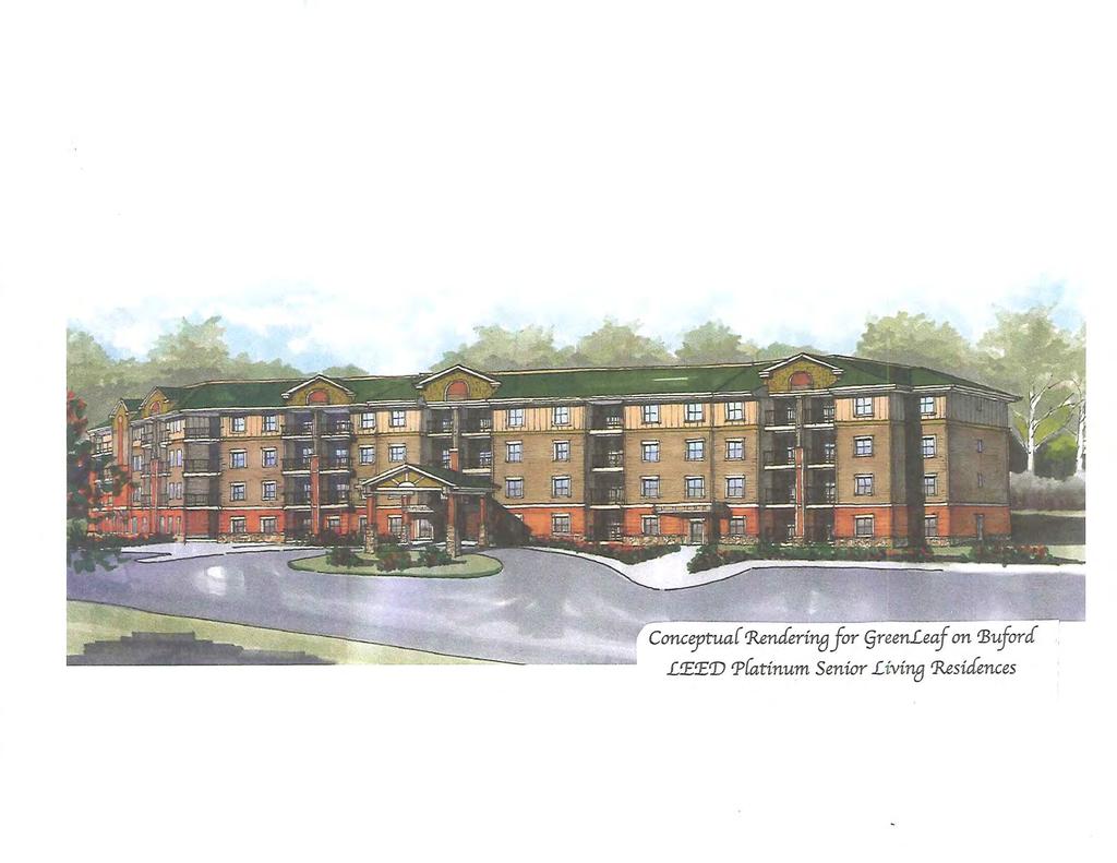
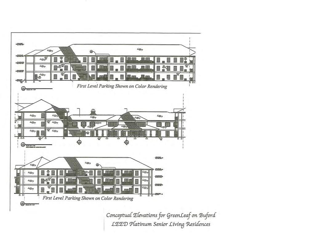
9 RZC , SUP & SUP (AM) PROJECT DATA: The applicant requests to rezone a 6.04-acre property from R-100 (Single Family Residence District) and MH (Mobile Home Park District) to O-I (Office-Institutional District), and a Special Use Permit to allow for the construction of a retirement community/assisted living facility. A second Special Use Permit is being requested to allow an increase in building height to four stories. The property is located on the west side of Buford Drive, just north of its intersection with Braselton Highway and across from Allen Drive. The property is developed with a single-family dwelling adjacent to Buford Drive and several mobile homes scattered on the remainder of the site. The submitted letter of intent indicates that the site would be developed with a 120-unit, senior living development with a maximum floor area of 100,000 square feet. The submitted rendering (see attached) depicts a four story building, which appears to include brick and stone exterior treatments on the structure. The submitted site plan indicates that the building would be three stories constructed above a first-floor parking deck. Additional parking would be constructed in front of the building and one driveway would extend onto Buford Drive. Although parking totals were not included on the site plan, it is noted that the parking allowance for a development of this type would be one space per 2 to 3 beds. The applicant has indicated that the development would be a senior living facility. However, it is unclear whether the facility would be independent living apartments or in the form of a personal care home/assisted living facility. The facility would be limited to individuals 62 years of age and older. Although the zoning buffers are not labeled on the site plan it appears that there is sufficient space to provide the required 50-foot wide, natural undisturbed buffer adjacent to residentiallyzoned property. ZONING HISTORY: The property has been zoned R-100 and MH since GROUNDWATER RECHARGE AREA: The subject property is located within an identified Significant Groundwater Recharge Area. The Development would be served by sanitary sewer, resulting in minimal impact. WETLANDS INVENTORY: The subject property does not contain areas, streams, and/or bodies of water depicted as wetlands on the U.S. Department of Interior, Fish, and Wildlife Service National Wetlands Inventory map on file with the Gwinnett Department of Planning and Development. 2
10 RZC , SUP & SUP (AM) OPEN SPACE AND GREENWAY MATER PLAN: No comment. DEVELOPMENT REVIEW SECTION COMMENTS: The Buffer, Landscape and Tree Ordinance requires a ten-foot wide landscape strip adjacent to all street rights-of-way. The Buffer, Landscape and Tree Ordinance requires submittal and approval of a Tree Preservation and Replacement Plan prepared by a professional landscape architect prior to securing a Land Disturbance or Development permit. Section of the 1985 Zoning Resolution requires screening of dumpsters and loading/unloading facilities. Parking lots and interior driveways shall be designed in accordance with Section 1001 of the 1985 Zoning Resolution. Parking spaces shall be provided at a ratio of: At a minimum, one space per 3 beds for a personal care/nursing home At a maximum, one space per 2 beds for a personal care/nursing home Section and/or of the Development Regulations requires a 200-foot deceleration lane with a 50-foot taper at each project entrance that proposes access to a Minor Collection Street or Major Thoroughfare. Right-of-way dedication to accommodate the deceleration lane and an 11- foot shoulder is also required. Reduction in length of a deceleration lane requires approval of a Modification by the Development Division; elimination of a deceleration lane requires approval of a Waiver by the Board of Commissioners. Section 6.13 of the Development Regulations requires construction of five-foot wide sidewalks along all exterior roadways adjoining the project, and four-foot wide sidewalks adjacent to both sides of all interior public streets (excluding cul-de-sac turnarounds). Section of the 1985 Zoning Resolution requires an additional five-foot setback for all structures (parking lots, driveways, detention ponds, retaining walls, etc.) adjacent to required buffers. The developer must submit detailed site development plans, including a landscape and tree preservation/replacement plan, for review and approval of the Development Division prior to any construction. The developer must obtain a Land Disturbance or Development Permit from the Development Division prior to any construction. 3
11 RZC , SUP & SUP (AM) Section of the Development Regulations requires submittal of a Storm Water Management Report for the project prior to obtaining a Land Disturbance or Development Permit. Section c of the Floodplain Management Ordinance requires that the lowest floor including the basement, of all non-residential building be constructed at an elevation of at least one foot above the 100-year floodplain. This project lies within an Activity Center/Corridor Overlay District, and is subject to all requirements set forth in Section 1315 of the Gwinnett County 1985 Zoning Resolution. STORMWATER REVIEW SECTION COMMENTS: No comment. GWINNETT COUNTY DEPARTMENT OF TRANSPORTATION COMMENTS: Buford Drive (SR 20) is a Principal Arterial and 60 feet of right-of-way is required from the centerline, with 75 feet required within 500 feet of a major intersection. Coordinate with the Georgia D.O.T. regarding access to Buford Drive (SR 20). GWINNETT COUNTY ENVIRONMENTAL HEALTH COMMENTS: No comment. GWINNETT COUNTY DEPARTMENT OF WATER RESOURCES COMMENTS: The available utility records show that the subject development is currently in the vicinity of a 12-inch water main located on the western right-of-way of Buford Drive. Due to the uncontrollable variables, the Department of Water Resources makes no guarantees as to the minimum pressures or volumes available at a specific point within its system. Demands imposed by the proposed development may require reinforcements or extensions of existing water mains. Any cost associated with such required reinforcements or extensions will be the responsibility of the development and will not be provided by this department. The available utility records show that the subject development is currently in the vicinity of an 8-inch sanitary sewer main located approximately 100 feet north of the property in the right-ofway of Rivershyre Parkway. The subject development is located within the Paterson service area. There are currently no connection restrictions within this service area. Treatment capacity within this area is presently available on a first come - first serve basis. Demands imposed by the proposed development may require reinforcements or extensions of existing sewer mains. Any cost associated with such required reinforcements or extensions 4
12 RZC , SUP & SUP (AM) will be the responsibility of the development and will not be provided by this department. Developer shall provide easements for future sewer connection to all locations designated by DWR during plan review. As-built information for this department is dependent upon outside entities to provide record drawings for the utilities. Therefore this department does not guarantee the accuracy of the information provided. Extensions of the water and/or sanitary sewer systems within the subject development must conform to this department s policies and Gwinnett County s ordinances. Proceeding design, construction, inspection, and final acceptance of the required utilities, service to these utilities would then become available under the applicable utility permit rate schedules. BUILDING CONSTRUCTION SECTION COMMENTS: Building Plan Review has no objections under the following conditions: 1. The applicant shall submit civil site drawings to Building Plan Review for review and approval. 2. The applicant shall submit architectural, structural, mechanical, electrical and plumbing drawings for each building for review and approval by Building Plan Review. 3. Each building shall comply with the height and area limitations of Table 503 and the fire resistive and horizontal separation requirements of Table 601 and 602 of the 2006 International Building Code with Georgia state amendments based on occupancy group classification, type of construction, and location of each building from property lines and other buildings. 4. Architectural design of the proposed building renovation shall incorporate the requirements of the Activity Center/Corridor Overlay District, Section 1315 of the 1985 Zoning Resolution of Gwinnett County. 5. Upon completion of plan review approvals, the applicant shall obtain a building permit for each building and achieve satisfactory field inspections for issuance of a Certificate of Occupancy. For assistance, you may contact this office at (678) Monday through Friday from the hours of 8:00 a.m. to 5:00 p.m. GWINNETT COUNTY FIRE SERVICES COMMENTS: Fire Plan Review has no objections to the above rezoning requests, under the following conditions: 1. Applicant submits civil drawings to Fire Plan Review for review and approval. 5
13 RZC , SUP & SUP (AM) 2. Applicant submits architectural drawings to Fire Plan Review for review and approval. 3. Upon completion of plan review approvals, applicant successfully achieves a satisfactory Fire field inspection, for issuance of a Certificate of Occupancy - Business Operation. For assistance, you may contact this office at (678) , Monday through Friday, from the hours of 8:00 a.m. to 5:00 p.m. DEPARTMENT ANALYSIS: The property is a 6.04-acre site located on the west side of Buford Drive, just north of its intersection with Braselton Highway and across from Allen Drive. The property is developed with a single-family dwelling adjacent to Buford Drive and several mobile homes are located on the remainder of the site. The 2030 Unified Plan Future Development Map indicates that the property lies within the Existing/Emerging Suburban Character Area, which could support a residential infill development. The property is located in an area that could be considered transitional in nature between single-family subdivisions and commercial/office uses along Buford Drive. The proposal could be consistent with policies for the character area, as the proposed retirement community/assisted living facility is residential in nature and could provide an additional housing option for elderly residents in the area. The Buford Drive corridor is generally characterized by residential developments extending northward from the subject property, and non-residential uses and zoning extending southward to Georgia Highway 316. Adjoining the subject site to the north is the Rivershyre single-family subdivision, zoned R-100 and located to the south is the Old Peachtree Station subdivision, zoned R-75 Cluster. Across Buford Drive are several undeveloped commercial tracts and an older industrial building, zoned C-2. Given the mix of residential and non-residential uses and zoning in the area, the proposed O-I zoning for a retirement community could be a suitable use for the area. It is noted that homes in Rivershyre and Old Peachtree Station are two stories in height. In light of the close proximity of the subject property to these residences, the requested four story building height may not be appropriate. If the height of the building is limited and full zoning buffers are maintained, the proposed use could be compatible with the neighboring residences of Rivershyre and Old Peachtree Station. In conclusion, the requested rezoning and Special Use Permit for a senior oriented residential development could be consistent with the Unified Plan, and with proper conditions could be compatible with land uses in the area. Therefore, the Department of Planning and Development recommends APPROVAL WITH CONDITIONS. However, the requested Special Use Permit for a building height increase may not be suitable in light of neighboring residences and therefore, the Department recommends DENIAL. 6
14 RZC , SUP & SUP (AM) PLANNING AND DEVELOPMENT DEPARTMENT RECOMMENDED CONDITIONS Approval as O-I with a Special Use Permit for a senior retirement community, subject to the following enumerated conditions: 1. To restrict the use of the property as follows: A. Limited to development as a retirement community for occupancy by persons 62 years of age and older as a special use. Final site design for the retirement community shall be subject to review and approval by the Director of Planning and Development. B. The development shall be limited to a maximum of 120 units and 100,000 square feet of building area. C. Limit the height of the buildings to no more than three stories or 35 feet. D. Buildings shall be finished with architectural treatments of brick or stacked stone on a minimum of 50% of each building elevation. The balance of each elevation shall be stucco or fiber-cement siding/shake. Final building elevations shall be subject to the review and approval of the Director of Planning and Development. E. All units shall incorporate applicable accessibility standards known as Easy Living Standards which shall include the following: Easy access step free feature at each entrance to the home. Easy passage feature, to include 32-inch wide doorways. Easy use feature, all units shall be one level. F. Provide a perimeter security fence around the entire property. Fence design, location and materials shall be subject to the review and approval of the Director of Planning and Development. 2. To satisfy the following site development considerations: A. Provide a 50-foot wide natural undisturbed buffer adjacent to all residentially-zoned properties. The buffer shall be enhanced where sparsely vegetated. B. Provide a ten-foot wide landscaped strip adjacent to Buford Drive. C. Natural vegetation shall remain on the property until the issuance of a development permit. D. Ground signage shall be limited to monument type sign(s) with a minimum two-foot high brick or stacked stone base. Ground sign(s) shall not exceed 10 feet in height and shall not be internally-illuminated. 7
15 RZC , SUP & SUP (AM) E. Dumpsters or trash compactors shall be screened by a 100% opaque brick or stacked stone wall with an opaque metal gate enclosure. Hours of dumpster pick-up shall be limited to between 7:00 am and 7:00 pm. F. Lighting shall be contained in cut-off type luminaries and shall be directed in toward the property so as not to shine directly into adjacent properties or rights-of-way. G. No tents, canopies, temporary banners, streamers or roping decorated with flags, tinsel, or other similar material shall be displayed, hung, or strung on the site. No decorative balloons or hot-air balloons shall be displayed on the site. Yard and/or bandit signs, signwalkers and sign-twirlers shall be prohibited. H. The property owner shall repaint or repair any graffiti or vandalism that occurs on the property within 72 hours. 8
16 RZC , SUP & SUP (AM) PLANNING AND DEVELOPMENT DEPARTMENT RECOMMENDATIONS STANDARDS GOVERNING EXERCISE OF ZONING SUITABILITY OF USE The proposed retirement community could be suitable in view of the site s location within a transitional area along the Buford Drive corridor, characterized by a variety of residential and non-residential land uses and zoning. ADVERSE IMPACTS With the recommended conditions, including full buffers and a building height limitation, the senior oriented retirement community should not be expected to have significant adverse impacts on neighboring properties. REASONABLE ECONOMIC USE AS ZONED The property has a reasonable economic use as currently zoned. IMPACTS ON PUBLIC FACILITIES An increase in traffic, storm water runoff, and utility demand could be expected from this request. CONFORMITY WITH POLICIES The 2030 Unified Plan Future Development Map indicates that the property is located within the Existing/Emerging Suburban Character Area, which supports residential development with a variety of housing options. If restricted to a retirement community with an appropriate height limitation, the use could provide a housing option for a growing elderly population and meet criteria as a transitional, infill development. CONDITIONS AFFECTING ZONING The use of the site for elderly housing could be suitable to this location, and could be expected to be a low impact, quiet neighbor. However, the proximity of the development to homes in two adjacent subdivisions suggests that the requested four-story building height is not appropriate. 9
17
18

19

20
21
22
23
24
25

26
27

28
29 R U S SE L L ROAD TIMBER OAK COVE 7-67 ASHWOOD WAY TIMBER L AUREL LANE 7-66 TROTTERS RIDGE FOXCROFT ROAD TH E LA N E 7-51 CORONADA TRAIL WILDCAT DRIVE CORONADA DRIVE LA MESA DRIVE HILLCREST WAY LAUREN CIRCLE 7-52 NORWALK COVE NORWALK TRACE 7-53 LAROSA DRIVE 7-26 GUNTER CIRCLE LAUREL HAVEN COURT LAUREL RIVER TRAIL TIMBERVALLEY LANE 7-50 RIVERFORD WAY RIVERLOCH WA Y LOS ALAMOS PLACE W OODLA ND LANE WOODLAND CIRCLE HUNTERS CREEK LANE H UNTERS C REEK COURT 7-27 PINBROOK DRIVE S UNNY FIELD LANE RIVERSHYRE P ARKWAY HI HOPE ROAD SHYRE CREST WAY ALLEN DRIVE OAKSHYRE PLACE RIVERSHYRE CIRCLE CREEK LAUR EL DRIVE LAR KSHYRE T RAIL SH Y REWOOD DRIVE LOCHWOOD TRAIL SHYREFORD CIRCLE VICTORIA STATIO N BOULEVARD 7-28 BRASELTON HIGHWAY PETTY ROAD 7-49 BROOK KNOLL PLACE LOCHSHYR E W AY ILLINOIS BEND READIN G COURT EAST DRIVE NORTHSIDE DRIVE MORNINGSIDE DRIVE EAST MORNINGSIDE DRIVE HI HOPE LANE LAKESIDE DRIVE MELODY LANE 7-29 PENNSYL V ANIA RUN SWANSON DRIVE 7-13 CRIPPLE CREEK DRIVE MICHAEL DRIVE GREGORY TRAIL INDIAN BRANCH WAY 7-30 COLLINS HILL ROAD 7-10 SONNY BOY LANE ERIC RUN COURT MUDDY RIVER ROAD LENDON LANE 7-11 FOREST WAY LAWRENCEVILLE RZC , SUP & SUP Printed: August 7, Feet BUFORD DRIVE WIMBERLY WAY REYN O LDS ROAD SR316E HIGHWAY 7-12 SR316W HIGHWAY HURRICANE SHOALS ROAD 5-208
30
31
32 ALLEN DRIVE RIVERSHYRE PARKWAY BUFORD DRIVE Printed: August 7, Feet SHORT LINE COURT VICTORIA STATION BOULEVARD RZC , SUP & SUP
33 WOODLAND CIRCLE STONESHYRE COURT 7-51 RIVERLOCH WAY MADISON OAK CIRCLE BUFORD DRIVE WOODLAND LANE R100 RA TIMBERSHYRE PLACE RIVERSHYRE PARKWAY ALLEN DRIVE 7-50 R100 RKSHYRE TRAIL SHYREFORD CIRCLE SHYREWOOD DRIVE 7-28 LOCHSHYRE COURT R75 SOUTHERN RUN VICTORIA STATIO N BOULEVA RD SHORT LINE COURT MH C2 C1 BRASELTON HIGHWAY NORTHSIDE DRIVE CHWOOD TRAIL EAST DRIVE R75CLU EAST MORNINGSIDE D ILLI N OIS BEND M1 READING COUR T 7-29 LAWRENCEVILLE M1 C1 RS180 MORNINGSIDE DRIVE BG RZC , SUP LM & SUP SWANSON DRIVE LAKESIDE DRIVE Printed: August 7, Feet BG C2 7-12
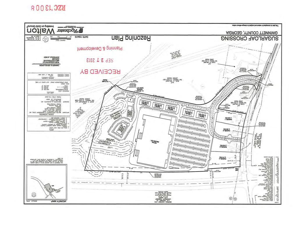
34 GWINNETT COUNTY DEPARTMENT OF PLANNING AND DEVELOPMENT REZONING ANALYSIS CASE NUMBER :RZC ZONING CHANGE :RA-200 TO C-2 LOCATION :1600 BLOCK OF WINDER HIGHWAY MAP NUMBER :R ACREAGE :39.07 ACRES PROPOSED DEVELOPMENT :RETAIL AND OFFICE USES (REDUCTION IN BUFFERS) SQUARE FEET :364,760 SQUARE FEET COMMISSION DISTRICT :(3) HUNTER FUTURE DEVELOPMENT MAP: RESEARCH AND DEVELOPMENT CORRIDOR APPLICANT: ROCHESTER & ASSOCIATES, INC. C/O MILL CREEK CONSULTING 4480 COMMERCE DRIVE, SUITE A BUFORD, GA CONTACT: MITCH PEEVY PHONE: OWNER: WUSF 2 SUGARLOAF, LLC & WALTON GEORGIA, LLC 4800 N. SCOTTSDALE ROAD, SUITE 4000 SCOTTSDALE, AZ DEPARTMENT RECOMMENDATION: APPROVAL WITH CONDITIONS PROJECT DATA: The applicant requests the rezoning of acres from RA-200 (Agriculture-Residence District) to C-2 (General Business District) to develop a retail shopping center and several office buildings. The proposed center would also include four retail outparcels. The property is located in the southwest quadrant of the intersection of Winder Highway and Georgia Highway 316. Presently, the subject property is developed with three single-family dwellings, a mobile home and several accessory structures. The proposed development would comprise 364,760 square-feet in several planned buildings. The submitted site plan shows a total of 266,700 square-feet in retail space in the main building, with the balance of the square footage proposed within six commercial/ retail buildings, two office buildings and four retail outparcels. The site plan indicates there would be two points of access provided off of Winder Highway, with one of the points being aligned with Alcovy Industrial Boulevard. A driveway is also shown stubbing to the rear property line for future development. A total of 1,079 parking spaces would be provided, which would meet the parking requirements for the proposed development.
35 RZC (TH) The proposed C-2 zoning requires a 75-foot zoning buffer when adjacent to residentially-zoned properties. Portions of proposed buildings, driveways and parking lots along the westernmost (side) property line would be located within the required 75-foot buffer. Therefore, the applicant is requesting elimination of the buffer along the western (side) and southern (rear) property lines. A 90-foot wide Colonial Pipeline easement and streams traverse along a majority of the southern (rear) property line, and are depicted on the submitted site plan. ZONING HISTORY: The property has been zoned RA-200 (Agriculture-Residence District) since GROUNDWATER RECHARGE AREA: The subject property is not located within an identified Significant Groundwater Recharge Area. WETLANDS INVENTORY: The subject property contains potential wetlands as depicted on the U.S. Department of Interior, Fish, and Wildlife Service National Wetlands Inventory Map or on the Federal Emergency Management Agency Flood Insurance Rate Map. The applicant/developer shall obtain all required approvals from Gwinnett County Department of Planning and Development and the U.S. Army Corps of Engineers. OPEN SPACE AND GREENWAY MATER PLAN: No comment. DEVELOPMENT REVIEW SECTION COMMENTS: The Buffer, Landscape and Tree Ordinance requires a ten-foot wide landscape strip adjacent to all street rights-of-way for non-residential developments. The Buffer, Landscape and Tree Ordinance requires submittal and approval of a Tree Preservation and Replacement Plan prepared by a professional landscape architect prior to securing a Land Disturbance or Development permit. Section of the 1985 Zoning Resolution requires screening of dumpsters and loading/unloading facilities. Parking lots and interior driveways shall be designed in accordance with Section 1001 of the 1985 Zoning Resolution. 2
36 RZC (TH) Parking spaces shall be provided at a minimum/maximum of: One space per sq. ft. for retail. One space per sq. ft. for office. Section and/or of the Development Regulations requires a 200-foot deceleration lane with a 50-foot taper at each project entrance that proposes access to a Minor Collector Street or Major Thoroughfare. Right-of-way dedication to accommodate the deceleration lane and an 11-foot shoulder is also required. Reduction in length of a deceleration lane requires approval of a Modification by the Development Division; elimination of a deceleration lane requires approval of a Waiver by the Board of Commissioners. Section 6.13 of the Development Regulations requires construction of five-foot wide sidewalks along all exterior roadways adjoining the project, and four-foot wide sidewalks adjacent to both sides of all interior public streets (excluding cul-de-sac turnarounds). Section of the 1985 Zoning Resolution requires an additional five-foot setback for all structures (parking lots, driveways, detention ponds, retaining walls, etc.) adjacent to required buffers. The developer must submit detailed site development plans, including a landscape & tree preservation/replacement plan, for review and approval of the Development Division prior to any construction. The developer must obtain a Land Disturbance or Development Permit from the Development Division prior to any construction. Section of the Development Regulations requires submittal of a Storm Water Management Report for the project prior to obtaining a Land Disturbance or Development Permit. Section c of the Floodplain Management Ordinance requires that the lowest floor, including the basement, of all non-residential buildings be constructed at an elevation of at least one foot above the 100-year floodplain. STORMWATER REVIEW SECTION COMMENTS: No comment. GWINNETT COUNTY DEPARTMENT OF TRANSPORTATION COMMENTS: Winder Highway is a Major Arterial and 50 feet of right-of-way is required from the centerline, with 60 feet required within 500 feet of a major intersection. Standard deceleration lane with appropriate taper and adequate right-of-way will be required. 3
37 RZC (TH) The project entrance shall align with Alcovy Industrial Boulevard in accordance with the Gwinnett County Development Regulations. Prior to the issuance of a Development Permit, a sight distance certification shall be provided. The number and locations of driveways are subject to Gwinnett County D.O.T. approval. Coordinate with the Georgia D.O.T. regarding access. Project must comply with Gwinnett County D.O.T. Criteria and Guidelines for Left Turn Lanes. Prior to issuance of a Development Permit, the applicant shall provide a traffic impact study and a signal warrant study. Prior to the issuance of the first certificate of occupancy, the applicant shall make any improvements recommended by the traffic impact study, provided the improvements are approved by the D.O.T. All design and construction will be subject to D.O. T. review and approval. If it is determined by the signal warrant study that a signal is warranted, and the signal is approved by the D.O.T., the applicant shall contract and pay for the signal design. The applicant shall also contract for the installation of the signal by a D.O.T. approved contractor. All design and construction will be subject to D.O.T. review and approval. The signal will be installed and operational prior to the issuance of the first certificate of occupancy. See additional comments in attached memorandum, dated October 10, GWINNETT COUNTY ENVIRONMENTAL HEALTH COMMENTS: No comment. GWINNETT COUNTY DEPARTMENT OF WATER RESOURCES COMMENTS: The available utility records show that the subject development is currently in the vicinity of a 10-inch water main located on the southern right-of-way of Winder Highway. Due to the uncontrollable variables, the Department of Water Resources makes no guarantees as to the minimum pressures or volumes available at a specific point within its system. Demands imposed by the proposed development may require reinforcements or extensions of existing water mains. Any cost associated with such required reinforcements or extensions will be the responsibility of the development and will not be provided by this department. The available utility records show that the subject development is currently in the vicinity of an 8-inch sanitary sewer main located approximately 2,200 feet west of the property. There is a dry sewer system in the right-of-way of Alcovy Industrial Boulevard. 4
38 RZC (TH) The subject development is located within the Patterson service area. There are currently no connection restrictions within this service area. Treatment capacity within this area is presently available on a first come - first serve basis. Demands imposed by the proposed development may require reinforcements or extensions of existing sewer mains. Any cost associated with such required reinforcements or extensions will be the responsibility of the development and will not be provided by this department. Developer shall provide easements for future sewer connection to all locations designated by DWR during plan review. As-built information for this department is dependent upon outside entities to provide record drawings for the utilities. Therefore this department does not guarantee the accuracy of the information provided. Extensions of the water and/or sanitary sewer systems within the subject development must conform to this department s policies and Gwinnett County s ordinances. Proceeding design, construction, inspection, and final acceptance of the required utilities, service to these utilities would then become available under the applicable utility permit rate schedules. BUILDING CONSTRUCTION SECTION COMMENTS: Building Plan Review has no objections under the following conditions: 1. The applicant shall submit civil site drawings to Building Plan Review for review and approval. 2. The applicant shall submit architectural, structural, mechanical, electrical and plumbing drawings for each building for review and approval by Building Plan Review. 3. Each building shall comply with the height and area limitations of Table 503 and the fire resistive and horizontal separation requirements of Table 601 and 602 of the 2006 International Building Code with Georgia state amendments based on occupancy group classification, type of construction, and location of each building from property lines and other buildings. 4. Upon completion of plan review approvals, the applicant shall obtain a building permit for each building and achieve satisfactory field inspections for issuance of a Certificate of Occupancy. For assistance, you may contact this office at Monday through Friday from the hours of 8:00 a.m. to 5:00 p.m. GWINNETT COUNTY FIRE SERVICES COMMENTS: Fire Plan Review has no objections to the above rezoning requests, under the following conditions: 1. Applicant submits civil drawings to Fire Plan Review for review and approval. 5
39 RZC (TH) 2. Applicant submits architectural drawings to Fire Plan Review for review and approval. 3. Upon completion of plan review approvals, applicant successfully achieves a satisfactory Fire field inspection, for issuance of a Certificate of Occupancy - Business Operation. For assistance, you may contact this office at (678) , Monday through Friday, from the hours of 8:00 a.m. to 5:00 p.m. DEPARTMENT ANALYSIS: The subject property consists of acres, and is part of a much larger tract of land located at the southwest corner of the intersection of Winder Highway and Georgia Highway 316. The site is partially wooded with pasture land, and contains multiple streams which meander throughout the southern portion of the property. The site also contains several residences and accessory structures that would be removed as part of the proposed development. The 2030 Unified Plan Future Development Map indicates the site is located within the Research and Development Corridor extending along Georgia Highway 316. Although not strictly consistent with the recommended land use, the request for a commercial/retail and office development could be suitable in light of the commercial and industrial developments immediately across Winder Highway, which includes a large shopping center (Stars and Strikes Plaza) containing a bowling alley, restaurants and a tire store. The Winder Highway and Georgia Highway 316 intersection is characterized by commercial uses and zoning along the northern and eastern sides, with the remainder being predominately zoned RA-200. The intersection is developed with uses including a convenience store, a freestanding restaurant, as well as a bowling alley/family entertainment center within the Stars and Strikes Plaza. The parcels immediately surrounding the site are zoned RA-200, and could potentially be part of a future development given the proposed driveway stub. The proposed commercial retail center could be consistent with the existing commercial uses found at this intersection. However, in view of the high visibility from Highway 316 and the architectural standards established in the immediate area; appropriate conditions including, enhanced architectural standards, landscape and signage conditions should be included. In conclusion, in light of the commercial nature of the area, the proposed commercial retail development could be appropriate at this location. Therefore, the Department of Planning and Development recommends APPROVAL WITH CONDITIONS of the requests. 6
40 RZC (TH) PLANNING AND DEVELOPMENT DEPARTMENT RECOMMENDED CONDITIONS Approval as C-2, subject to the following enumerated conditions: 1. To restrict the use of the property as follows: A. Retail, service-commercial, office and accessory uses. The following uses shall be prohibited: adult bookstores or entertainment contractors offices extended stay hotels or motels recovered materials processing facilities smoke shops/novelty stores yard trimmings composting facilities B. Buildings shall be finished with architectural treatments of glass, brick and/or stacked stone on all sides (stucco may only be used as an accent material). Final building elevations shall be submitted for review and approval by the Director of Planning and Development. 2. To abide by the following site development considerations: A. Provide a 75-foot wide natural undisturbed buffer adjacent to all residentially-zoned properties. B. Provide a ten-foot wide landscaped strip adjacent to all rights-of-way. C. Provide a 5-foot wide landscaped strip adjacent to all internal property lines. D. Natural vegetation shall remain on the property until the issuance of a development permit. E. Ground signage shall be limited to monument type sign(s) with a minimum two-foot high brick or stacked stone base. F. Billboards or oversized signs shall be prohibited. G. Outdoor storage shall be prohibited, except for any garden supply center which shall be enclosed with decorative fencing and located adjacent to the main building. H. Dumpsters shall be screened by a 100% opaque brick or stacked stone wall with an opaque metal gate enclosure. I. Outdoor loudspeakers shall be prohibited. 7
41 RZC (TH) J. Lighting shall be contained in cut-off type luminaries and shall be directed in toward the property so as not to shine directly into adjacent properties or rights-of-way. K. No tents, canopies, temporary banners, streamers or roping decorated with flags, tinsel, or other similar material shall be displayed, hung, or strung on the site. No decorative balloons or hot-air balloons shall be displayed on the site. Yard and/or bandit signs, signwalkers and sign-twirlers shall be prohibited. L. Peddlers and/or parking lot sales shall be prohibited. M. The property owner shall repaint or repair any graffiti or vandalism that occurs on the property within 72 hours. 3. To abide by the following requirements, dedications and improvements: A. The project entrance shall align with Alcovy Industrial Boulevard in accordance with the Gwinnett County Development Regulations. B. Prior to issuance of a Development Permit, the applicant shall provide a signal warrant study for the project entrance at the intersection of Alcovy Industrial Boulevard and Winder Highway. C. If it is determined by the signal warrant study that a signal is warranted, and the signal is approved by the DOT, the applicant shall contract and pay for the signal design. The applicant shall also contract for the installation of the signal by a DOT approved contractor. All design and construction will be subject to DOT review and approval. The signal will be installed and operational prior to the issuance of the first certificate of occupancy. D. Prior to the issuance of the first certificate of occupancy, the applicant shall make the improvements recommended by the traffic impact study, provided the improvements are approved by the DOT. Additionally, the following conditions from the Gwinnett DOT and Georgia DOT shall be met, and all design and construction will be subject to DOT review and approval: 1. At Site Driveway #1, construct a northbound channelized right-turn lane along Winder Highway to serve traffic entering the site. 2. A median shall be constructed to prevent left turns into or out of Driveway #1. 3. At Driveway #2, construct a southbound left-turn lane along Winder Highway to serve traffic entering the site (sufficient storage shall be provided to meet GDOT requirements). 8
42 RZC (TH) 4. A traffic signal (if or when warranted) shall be provided at Driveway #2. Provide signal interconnects as required by GCDOT and GDOT. 5. At Driveway #2, construct a northbound channelized right-turn lane along Winder Highway to serve traffic entering the site. 6. At the intersection of Winder Highway with Highway 316, construct one additional northbound left-turn lane (creating dual left-turn lanes) along Winder Highway. 7. Construct one additional westbound left-turn lane (creating dual left-turn lanes along Highway 316). Create dual southbound receiving lanes along Winder Highway to accommodate these westbound dual left-turn lanes. 8. Construct one additional northbound and one additional southbound through lane on Winder Highway (creating dual through lanes for traffic crossing Highway 316 in both directions). 9. All design, right of way, and construction for the proposed improvements shall be paid for and provided by the developer. 9
43 RZC (TH) PLANNING AND DEVELOPMENT DEPARTMENT RECOMMENDATIONS STANDARDS GOVERNING THE EXERCISE OF ZONING SUITABILITY OF USE The proposed use could be suitable at this location, as it is a compatible use with the existing commercial node at the intersection of Winder Highway and Georgia Highway 316. ADVERSE IMPACTS With the recommended conditions, the proposed development would not be expected to adversely impact adjacent or nearby properties. In view of the high visibility from Highway 316 and the architectural standards established in the immediate area; appropriate conditions including, enhanced architectural standards, landscape and signage conditions should be included. REASONABLE ECONOMIC USE AS ZONED The property has a reasonable economic use as currently zoned. IMPACT ON PUBLIC FACILITIES An increase in traffic, storm water runoff, and utility demand would be expected. CONFORMITY WITH POLICIES Although not strictly consistent with the recommended land use, the proposed C-2 zoning for a retail/commercial and office development could be consistent with the zoning and development pattern established by the Board at the Winder Highway/Georgia Highway 316 intersection. CONDITIONS AFFECTING ZONING In light of the property s location at a major intersection along Georgia Highway 316, accompanied with the scale of the proposed development and its anticipated traffic impacts, the recommended conditions received from the Gwinnett and Georgia Departments of Transportation should be included in any rezoning approval. 10

44
45
46
47 M E M O R A N D U M To: From: Subject: Jeff West Lewis Cooksey RZC Sugarloaf Crossing TIS Date: October 10, 2013 Sugarloaf Crossing Traffic Impact Study RZC The above listed Traffic Impact Study has been reviewed. Since the proposed project is located at the intersection of two state routes, the study was provided to the Georgia Department of Transportation for review in addition to the Gwinnett County DOT review. Review comments from both entities are summarized as follows: At Site Driveway #1, construct a northbound channelized right-turn lane along SR 8 to serve traffic entering the site A median shall be constructed to prevent left turns into or out of Driveway #1 At Driveway #2, construct a southbound left-turn lane along SR 8 to serve traffic entering the site (sufficient storage shall be provided to meet GDOT requirements) A traffic signal (if or when warranted) shall be provided at Driveway #2. Provide signal interconnects as required by GCDOT and GDOT. At Driveway #2, construct a northbound channelized right-turn lane along SR 8 to serve traffic entering the site At the intersection of SR 8 with SR 316, construct one additional northbound left-turn lane (creating dual left-turn lanes) along SR 8 Construct one additional westbound left-turn lane (creating dual left-turn lanes along SR 316). Create dual southbound receiving lanes along SR 8 to accommodate these westbound dual left-turn lanes Construct one additional northbound and one additional southbound through lane on SR 8 (creating dual through lanes for traffic crossing SR 316 in both directions) All design, right of way, and construction for the proposed improvements shall be paid for and provided by the developer. If you have any questions, please let me know.
48 SUGARLOAF PARKWAY HURRICANE TRAIL FENCE ROAD STANLEY ROAD DACULA VILLA G E BROAD STREET ALCOVY INDUSTRIAL BOULEVARD SR316W HIGHWAY WINDER HIGHWAY SR316E HIGHWAY PIPELINE ROAD CEDARS ROAD BILLY MCGEE R OAD KEY MANOR LANE HARDY IVES LANE HARDY WATER DRIVE ROCK HOUSE ROAD RZC CEDARS ROAD Printed: September 10, 2013 TULIP LANE EAST ROCK HOUSE ROAD Feet LILY VALLEY DRIVE ALCOVY RIVER GREENSPACE (DIXON TRACT) FERN WALK ALCOVY FALLS DRIVE LITTLE CREEK ROAD DOUBLE CREEK DRIVE ALCOVY TRACE WAY ALCOVY PARK DRIVE
49
50 DACULA ALCOVY INDUSTRIAL BOULEVARD WINDER HIGHWAY SR316W HIGHWAY SR316E HIGHWAY RZC Printed: September 10, Feet
51 PIPELINE ROAD FENCE ROAD R WINDER HIGHWAY M1 STANLEY ROAD C2 DACULA PMUD M2 C2 ALCOVY INDUSTRIAL BOULEVARD R M SR316W HIGHWAY SR316E HIGHWAY RA200 MH RA200 TRD RZT RZC ALCOVY RIVER GREENSPACE (DIXON TRACT) Printed: September 10, 2013 Y WATER DRIVE ASTER IVES DRIVE Feet FERN WALK CSO
52 GWINNETT COUNTY DEPARTMENT OF PLANNING AND DEVELOPMENT REZONING AND SPECIAL USE PERMIT ANALYSIS CASE NUMBER :RZR ZONING CHANGE :RA-200 TO R-100 CSO LOCATION :3000 BLOCK OF OLD THOMPSON MILL ROAD MAP NUMBERS :R & 765 & R ACREAGE :52.15 ACRES UNITS :104 UNITS PROPOSED DEVELOPMENT :SINGLE-FAMILY CONSERVATION SUBDIVISION COMMISSION DISTRICT :(4) HEARD CASE NUMBER :SUP ZONING :R-100 (PROPOSED) LOCATION :3000 BLOCK OF OLD THOMPSON MILL ROAD MAP NUMBERS :R & 765 & R ACREAGE :52.15 ACRES UNITS :104 UNITS PROPOSED DEVELOPMENT :SINGLE-FAMILY CONSERVATION SUBDIVISION COMMISSION DISTRICT :(4) HEARD FUTURE DEVELOPMENT MAP: EXISTING/EMERGING SUBURBAN APPLICANT: RIDGELINE LAND PLANNING, INC. 533 ROSEWOOD CIRCLE WINDER, GA CONTACT: HOLT PERSINGER PHONE: OWNER: BYRON HUGH HOSCH 3000 HOSCH VALLEY ROAD BUFORD, GA DEPARTMENT RECOMMENDATION: APPROVAL WITH CONDITIONS PROJECT DATA: The applicant requests rezoning of a acre parcel assemblage from RA-200 (Agriculture- Residence District) to R-100, along with a Special Use Permit in order to develop a 104-lot Conservation Subdivision. The site is mostly pasture land with some wooded areas and streams meandering throughout the property. A single-family dwelling and accessory structures are situated near Old Thompson Mill Road. The property is bisected by two large power lines belonging to Georgia Power Company and Jackson Electric Membership Corporation. The Georgia Power Company power line is a separately owned parcel which is not part of this request, other than to join the properties together through a vehicular access easement which would need to be obtained by the developer.
53 RZR & SUP (TH) The gross area of the subject site is acres, and the net area of the site is acres, as the property contains acres located within a 100-year floodplain. The applicant has chosen the option of providing conservation space equal to 41% (21.2-acres) of the gross area in exchange for a density allowance of up to 2.3 units per acre. The net density for the 104- unit development would be 2.24 units per acre. In keeping with the goal of the CSO ordinance for preservation of sensitive lands, the site plan indicates a large area consisting of wetlands located in the northernmost portion of the property, as well as areas along both streams, would be preserved as open space. The site plan indicates that a total of 21.2-acres of conservation space, with 7.76-acres of secondary conservation or recreation area would be provided. As such, the minimum requirements for conservation space and recreational area would be met. The site plan reflects a 50-foot wide buffer along the streams forming the northern and eastern property lines; with stream buffers also being shown along the streams meandering throughout the property. Also, a 50-foot street frontage buffer is shown along the right-of-way of Old Thompson Mill Road. The applicant has proposed a minimum home size of 1,600 square feet for one-story and 1,800 square feet for two-story homes. Home exteriors would be constructed of brick, stacked stone, cedar shake, stucco or fiber cement siding, and all units would have two-car garages. The lot chart provided by the applicant indicates the average lot width of the development would be feet, with the minimum lot width being 60 feet. Access for the development would be provided by a single street connecting to Old Thompson Mill Road, just west of its intersection with Hosch Valley Road. ZONING HISTORY: The property has been zoned RA-200 since GROUNDWATER RECHARGE AREA: The subject property is not located within an identified Significant Groundwater Recharge Area. WETLANDS INVENTORY: The subject property contains potential wetlands as depicted on the U.S. Department of Interior, Fish, and Wildlife Service National Wetlands Inventory Map or on the Federal Emergency Management Agency Flood Insurance Rate Map. The applicant/developer shall obtain all required approvals from Gwinnett County Department of Planning and Development and the U.S. Army Corps of Engineers. OPEN SPACE AND GREENWAY MATER PLAN: No comment. 2
54 RZR & SUP (TH) DEVELOPMENT REVIEW SECTION COMMENTS: The Buffer, Landscape and Tree Ordinance requires a ten-foot wide no-access easement along classified roadways for residential developments. The Buffer, Landscape and Tree Ordinance requires submittal and approval of a Tree Preservation and Replacement Plan prepared by a professional landscape architect prior to securing a Land Disturbance or Development permit. Section of the Development Regulations requires that six percent (6%) of the gross land area be set aside as recreation area (not to exceed six acres) and that not over 60 percent of the required recreation area may be located in a 100-year floodplain. The recreation area may be reduced to three percent (3%) of the gross land area if developed with a swimming pool, tennis court, and amenity parking. Section c of the 1985 Zoning Resolution requires that exclusion of 50% of proposed permanent lakes used for wet detention, impervious surface in recreation areas, and land within power, gas, or sewer easements and pump stations from conservation space calculations. All open space areas/common areas shall meet the minimum road frontage and lot width requirements for a lot within the subdivision. Section and/or of the Development Regulations requires a 200-foot deceleration lane with a 50-foot taper at each project entrance that proposes access to a Minor Collection Street or Major Thoroughfare. Right-of-way dedication to accommodate the deceleration lane and an 11- foot shoulder is also required. Reduction in length of a deceleration lane requires approval of a Modification by the Development Division; elimination of a deceleration lane requires approval of a Waiver by the Board of Commissioners. Section 6.13 of the Development Regulations requires construction of five-foot wide sidewalks along all exterior roadways adjoining the project, and four-foot wide sidewalks adjacent to both sides of all interior public streets (excluding cul-de-sac turnarounds). The developer must submit a preliminary plat (construction plans), including a grading plan, tree plan, and road/sewer profiles for review and approval of the Development Division prior to any construction. Section of the Development Regulations requires submittal of a Storm Water Management Report for the project prior to obtaining a Land Disturbance or Development Permit. Section b of the Floodplain Management Ordinance requires that the lowest floor, including the basement, of all residential buildings be constructed at an elevation of at least three feet above the 100-year floodplain. Note that all recreation areas, open space and/or common areas (including storm water detention facility lots) located within the development shall be controlled by a mandatory Property Owner s 3
55 RZR & SUP (TH) Association (to include reported bylaws) with responsibility for maintenance, insurance, and taxes for open space areas. STORMWATER REVIEW SECTION COMMENTS: Stormwater management will be required for the proposed development outside of environmental protective buffered areas on the property. GWINNETT COUNTY DEPARTMENT OF TRANSPORTATION COMMENTS: Old Thompson Mill Road is a Minor Collector and 30 feet of right-of-way is required from the centerline. Standard deceleration lane with appropriate taper and adequate right-of-way will be required. The number and locations of driveways are subject to Gwinnett County D.O.T. approval. Project must comply with Gwinnett County D.O.T. Criteria and Guidelines for Left Turn Lanes. GWINNETT COUNTY ENVIRONMENTAL HEALTH COMMENTS: No comment. GWINNETT COUNTY DEPARTMENT OF WATER RESOURCES COMMENTS: The available utility records show that the subject development is currently in the vicinity of an 8-inch water main located in the right-of-way of Old Thompson Mill Road. Due to the uncontrollable variables, the Department of Water Resources makes no guarantees as to the minimum pressures or volumes available at a specific point within its system. Demands imposed by the proposed development may require reinforcements or extensions of existing water mains. Any cost associated with such required reinforcements or extensions will be the responsibility of the development and will not be provided by this department. The available utility records show that the subject development is currently in the vicinity of an 8-inch sanitary sewer main located approximately 150 feet east of the property in the right-ofway of Morgan Box Court. The subject development is located within the Crooked Creek service area. There are currently no connection restrictions within this service area. Treatment capacity within this area is presently available on a first come - first serve basis. Demands imposed by the proposed development may require reinforcements or extensions of existing sewer mains. Any cost associated with such required reinforcements or extensions will be the responsibility of the development and will not be provided by this department. 4
56 RZR & SUP (TH) Developer shall provide easements for future sewer connection to all locations designated by DWR during plan review. As-built information for this department is dependent upon outside entities to provide record drawings for the utilities. Therefore this department does not guarantee the accuracy of the information provided. Extensions of the water and/or sanitary sewer systems within the subject development must conform to this department s policies and Gwinnett County s ordinances. Proceeding design, construction, inspection, and final acceptance of the required utilities, service to these utilities would then become available under the applicable utility permit rate schedules. BUILDING CONSTRUCTION SECTION COMMENTS: No comment. GWINNETT COUNTY FIRE SERVICES COMMENTS: No comment. DEPARTMENT ANALYSIS: The subject property is a acre parcel located on Old Thompson Road, at its intersection with Hosch Valley Road, near the Hall County line. The property is partially wooded, with pasture lands and streams meandering throughout the property. The 2030 Unified Plan Future Development Map indicates the property is located within an Existing/Emerging Suburban Character Area. Policies for this Character Area encourage singlefamily residential uses, and promote a variety of housing options. With conditions to ensure the quality of the development and its compatibility with the surrounding area, an R-100 CSO Conservation Subdivision, at a density of 2.24 units per acre, could be consistent with these policies and map designation. The surrounding area is residential in character including numerous large lot residences and several neighboring single-family subdivision developments. North of the property is the Windgate subdivision, which is zoned and developed as an R-100 subdivision (RZ ). Immediately adjacent to the north and west of the property are large tracts of land zoned RA- 200 and an undeveloped R-100 Modified zoning district (RZR & SUP ). Located to the north and east is the Duncan Park subdivision, zoned R-100 Modified (RZ & SUP ). To the south of the property, across Old Thompson Mill Road are large lots with scattered single family residences and accessory structures zoned RA-200. The most recent similar zoning approval for the area included conditions requiring a minimum of 2,000 square feet for one-story homes and 2,200 square feet for two-story homes, along with masonry front facades and two-car garages. In light of the existence of subdivision developments in the immediate area, including other similar R-100 and R-100 Modified subdivisions, the request 5
57 RZR & SUP (TH) could be considered suitable at this location, provided conditions are established which ensure compatibility with adjacent and nearby developments. In conclusion, the request is considered consistent with the Unified Plan and could be compatible with previous Board actions approving similar subdivision developments in the area. Therefore, the Department of Planning and Development recommends APPROVAL WITH CONDITIONS of this request. 6
58 RZR & SUP (TH) PLANNING AND DEVELOPMENT DEPARTMENT RECOMMENDED CONDITIONS Approval as R-100 CSO (Single Family Conservation Subdivision Overlay), subject to the following enumerated conditions: 1. To restrict the use of the property as follows: A. Single-family residential and accessory uses and structures, not to exceed 104 lots. B. Homes shall be constructed with front facades of primarily brick, stacked stone, cedar shake or stucco. The balance of the home may be the same materials, or of fiber-cement siding. C. The minimum heated floor area per dwelling shall be 1,800 square feet for one-story homes and 2,000 square feet for two-story homes. D. All homes shall have at least a double-car garage. 2. To satisfy the following site development considerations: A. All grassed areas on dwelling lots shall be sodded. B. All utilities shall be placed underground. C. Natural vegetation shall remain on the property until the issuance of a development permit. D. The Old Thompson Mill Road frontage shall include a landscaped entrance feature. Landscape and signage plans shall be subject to review and approval of the Director of Planning and Development. 7
59 RZR & SUP (TH) PLANNING AND DEVELOPMENT DEPARTMENT RECOMMENDATIONS STANDARDS GOVERNING THE EXERCISE OF ZONING SUITABILITY OF USE The request is considered suitable at this location in light of existing R-100 and R-100 Modified subdivision developments in the area and the planned preservation of substantial portions of the site for open space. ADVERSE IMPACTS With the recommended conditions, potential impacts should be minimized. REASONABLE ECONOMIC USE AS ZONED The subject property has a reasonable economic use as currently zoned. IMPACT ON PUBLIC FACILITIES An increased impact on public facilities could be anticipated in the form of increased traffic, school enrollment, storm water runoff, and utility demand. CONFORMITY WITH POLICIES The request is consistent with policies the Unified Plan, and with similar zoning and developments in the surrounding area. CONDITIONS AFFECTING ZONING The forested areas and streams on the site lend supporting grounds for utilization of the CSO option. 8
60
61
62
63 NORTH PUCKETT ROAD Hall County W INDGATE DRIVE 1-3 HILL POND DRIVE THOMPSON LAKE DRIVE WEST ROCK QUARRY ROAD OLD THOMPSON MILL ROAD KEENLY IVES COURT EXPRESS LANE DUNCAN IVES DRIVE GEM IVES COURT BRASELTON TUGGLE IV E S DRI V E PERIMETER CIRCLE MOON CHASE LANE OLD THOMPSON MILL ROAD KNOLLWOOD COURT HADDON HALL DRIVE IVY MILL DRIVE HAMILTON MILL ROAD BERRY RIDGE LANE HADDON HALL COURT PLANTATION M B UREL MILL DRIVE ILL DRIVE CASCADE FALL DRIVE PLA NTATION MILL TRAIL CASCADE IVE DRIVE CAST PALM DRIVE 1-1 RIP RAP DRIVE VICTORIA DRIVE TUGGLE ROAD WEST ROCK Q UARRY ROAD RZR & SUP Printed: October 8, 2013 SPRING CAST DRIVE CAST BE N D WAY ,000 Feet SARDIS WAY SUTTON WOOD WAY SEDGEVIEW LANE SEDGEVIEW WAY GRANDOVER DRIVE HOSCH VALLEY ROAD SARDIS CHURCH ROAD DOC HUGHES ROAD KAY MORGAN ROAD 1-2 LENOX PARK DRIVE HAMILTON PARC LANE HARTHORNE LANE DUNCAN BRIDGE DRIVE THOMPSON MILL ROAD TALLEY LANE WYNDHAM PARK DRIVE SARDIS MILL TRAIL DUNCAN BRIDG E T RAIL SARDIS MILL COURT WYNDHAM RIDGE COURT KELLY COVE DRIVE 3-7 SHAY TERRACE BRANDON ACRES DRIVE

64
65
66 OLD THOMPSON MILL ROAD WINDGATE DRIVE EXPRESS LANE MORGAN BOX COURT IVE S DRIVE EXPRESS DRIVE EXPRESS IVES C KEENLY IVES COURT DUNCAN KEENLY VALLEY DRIVE RZR & SUP Printed: October 9, Feet HOSCH VALLEY ROAD
67 WINDGATE DRIVE R100 WINDWARD GATE LANE Hall County R100MOD R100 RA200 OLD THOMPSON MILL ROAD BRASELTON MORGAN BOX COURT KEENLY KEENLY IVES COURT VALLEY DRIVE EXPRESS LANE R100MOD DUNCAN IVES DRIVE EXPRESS DRIVE EXPRESS IVES COURT SHARP CREEK LANE GEM IVES CO HOSCH VALLEY ROAD RZR & SUP THOMPSON MILL ROAD Printed: October 8, Feet
68 GWINNETT COUNTY DEPARTMENT OF PLANNING AND DEVELOPMENT SPECIAL USE PERMIT ANALYSIS CASE NUMBER :SUP ZONING :R-100 LOCATION :100 BLOCK OF RUSSELL ROAD MAP NUMBER :R ACREAGE :2.0 ACRES SQUARE FEET :3,500 SQUARE FEET PROPOSED DEVELOPMENT :FAMILY PERSONAL CARE HOME COMMISSION DISTRICT :(4) HEARD FUTURE DEVELOPMENT MAP: EXISTING/EMERGING SUBURBAN APPLICANT: MARIANA CRISTEA 1643 TAYLOR OAKS DRIVE LAWRENCEVILLE, GA CONTACT: MARIANA CRISTEA PHONE: OWNER: MARIANA CRISTEA 1643 TAYLOR OAKS DRIVE LAWRENCEVILLE, GA DEPARTMENT RECOMMENDATION: APPROVAL WITH CONDITIONS PROJECT DATA: The applicant requests a Special Use Permit on a 2.0-acre parcel, zoned R-100 (Single Family Residence District), to allow a family personal care home. The property is located on the north side of Russell Road, between Collins Hill Road and Lawrenceville-Suwanee Road. The property is currently developed with a one-story single-family dwelling, and an accessory structure. The existing single-family dwelling and accessory structure would be demolished, with the intent of constructing an approximately 3,500 square foot, ranch style, single-family dwelling, which would be occupied by up to 6 elderly residents needing assistance with daily activities. Access would be provided by a single driveway extending from Russell Road. Two new septic drain fields would be installed in the side and rear yards. ZONING HISTORY: The property has been zoned R-100 since 1970.
69 SUP (TH) GROUNDWATER RECHARGE AREA: The subject property is not located within an identified Significant Groundwater Recharge Area. WETLANDS INVENTORY: The subject property does not contain areas, streams, and/or bodies of water depicted as wetlands on the U.S. Department of Interior, Fish, and Wildlife Service National Wetlands Inventory map on file with the Gwinnett Department of Planning and Development. DEVELOPMENT REVIEW SECTION COMMENTS: No comment. STORMWATER REVIEW SECTION COMMENTS: No comment. GWINNETT COUNTY DEPARTMENT OF TRANSPORTATION COMMENTS: No comment. GWINNETT COUNTY ENVIRONMENTAL HEALTH COMMENTS: Contact GCEHD regarding the septic tank permitting process. GWINNETT COUNTY DEPARTMENT OF WATER RESOURCES COMMENTS: The available utility records show that the subject development is currently in the vicinity of an 6-inch water main located on the eastern right-of-way of Russell Road. Due to the uncontrollable variables, the Department of Water Resources makes no guarantees as to the minimum pressures or volumes available at a specific point within its system. Demands imposed by the proposed development may require reinforcements or extensions of existing water mains. Any cost associated with such required reinforcements or extensions will be the responsibility of the development and will not be provided by this department. The available utility records show that the subject development is currently in the vicinity of an 8-inch sanitary sewer main located approximately 600 feet south of the property in the right-ofway of Heathridge Court. The subject development is located within the Patterson service area. There are currently no connection restrictions within this service area. Treatment capacity within this area is presently available on a first come - first serve basis. 2
70 SUP (TH) Demands imposed by the proposed development may require reinforcements or extensions of existing sewer mains. Any cost associated with such required reinforcements or extensions will be the responsibility of the development and will not be provided by this department. Developer shall provide easements for future sewer connection to all locations designated by DWR during plan review. As-built information for this department is dependent upon outside entities to provide record drawings for the utilities. Therefore this department does not guarantee the accuracy of the information provided. Extensions of the water and/or sanitary sewer systems within the subject development must conform to this department s policies and Gwinnett County s ordinances. Proceeding design, construction, inspection, and final acceptance of the required utilities, service to these utilities would then become available under the applicable utility permit rate schedules. BUILDING CONSTRUCTION SECTION COMMENTS: No comment. GWINNETT COUNTY FIRE SERVICES COMMENT No comment. DEPARTMENT ANALYSIS: The property is located on the north side of Russell Road, between Collins Hill Road and Lawrenceville-Suwanee Road. The property is currently developed with a small single-family dwelling and an accessory structure. The 2030 Unified Plan Future Development Map indicates that the site is located within an Existing/Emerging Suburban Character Area. This Character Area primarily supports residential uses and encourages a variety of housing options, including housing for the elderly. As such, the subject property s use as a family personal care home for elderly housing and care could be compatible with the recommendations of the Unified Plan. The surrounding area is primarily developed with single-family subdivisions, and homes on large lots, within the R-100 and R-75 zoning districts. Surrounding properties are primarily acreage tracts, developed with single-family homes. The subject property contains 2.0-acres, is not part of a platted subdivision and appears to be adequately separated from neighboring residences for the proposed use. Given these circumstances, a family personal care home could be compatible with adjacent and nearby residential uses. In conclusion, the requested Special Use Permit could be compatible with policies of the Unified Plan and the residential zoning and development patterns of the area. Therefore, the Department of Planning and Development recommends APPROVAL WITH CONDITIONS of the request. 3
71 SUP (TH) PLANNING AND DEVELOPMENT DEPARTMENT RECOMMENDED CONDITIONS Approval of a Special Use Permit for a Family Personal Care Home, subject to the following enumerated conditions: 1. Limited to a state-licensed Family Personal Care Home providing residence and care for up to a maximum of eight elderly individuals (clients) residing in the home. 2. Exterior signage advertising the Family Personal Care Home shall be prohibited. 3. Any new building(s) shall be of a traditional residential style, compatible with the homes in the surrounding area. Architectural elevations, building materials and colors shall be subject to review and approval of the Director of Planning and Development prior to the issuance of a building permit. 4. Maintain a minimum 20-foot wide buffer along all exterior property lines, except for driveways and existing encroachments. 4
72 SUP (TH) PLANNING AND DEVELOPMENT DEPARTMENT RECOMMENDATIONS STANDARDS GOVERNING EXERCISE OF ZONING SUITABILITY OF USE The requested Special Use Permit for a family personal care home could be suitable in light of the residential nature of zoning and development in the area, and the property s size and separation from neighboring residences. ADVERSE IMPACTS With the recommended conditions, potential impacts could be reduced. REASONABLE ECONOMIC USE AS ZONED The property has a reasonable economic use as currently zoned. IMPACTS ON PUBLIC FACILITIES It is anticipated there would be additional impacts on public facilities in the form of traffic and utility demand from the proposed use and building. CONFORMITY WITH POLICIES The request could be considered compatible with policies of the 2030 Unified Plan, which support residential uses for the area, including elderly housing. CONDITIONS AFFECTING ZONING The property is located in an area that is developed primarily with single-family subdivisions and residences on large lots. Prohibiting exterior commercial signage for the family personal care home could help maintain the residential character of the area. 5

73
74

75
76 7-109 MERRYMOUNT DRIVE CAPE LIBERTY DRIVE LITTLE RIVE R DRIVE WILDCAT CLIFFS LANE WILDCAT CLIFFS W AY WILDCAT LAKE DRIVE SPRING ROSE GLEN SWEET IVY LANE COLLINS HILL GOLF COURSE 7-89 DAWN COURT DEER TRAIL DEERWOOD DRIVE L AKE HAVE N WAY YORK RIVE R WAY TAYLOR ROAD QUINTON PLACE LA UREL LAKE DRIVE RICHL AKE DR 7-87 I VE FERNWOOD DRIVE SIDNEYS COVE OAK VILLAG E LANE AMBER DAWN WAY CAMILE COURT STONE FOREST DRIVE TYLER TRACE S T ONEBR O OK WAY GOLD MAPLE ROAD 7-88 FOSTER TRACE COURT FOSTER TRACE DRIVE BERKTEN LANE ABINGER WAY WATFORD GLEN ROSEDOWN WAY RO S EDOWN C OURT ADGER COURT ABINGER LANE TIDEW E LL TRACE LAUREL CREEK DRIVE CREEK FRONT WAY 7-66 SUWANEE EAST DR 7-85 HUNT RIVER WAY ALLATOONA ROAD IVE LAWRENCEVILLE SUWANEE ROAD MARSH CREEK DRIVE HEARTH PLACE STERLIN G POINTE COURT BRIGHTON DRIVE PENNY LANE OAK SPRINGS DRIVE TRAIL INWOOD 7-69 RIVERTON DRIVE PENDLETON PLACE LAKE S HADOW WAY CIRCLE RIDGE RUSSELL ROAD RUSTIC HAMB RIDGE COURT RUSSELL RIDGE DRIVE 7-48 ASHBROOK DRIVE CHANTILLY LANE 7-68 PAMELA KAY DRIVE WINDS OR CHASE DRIVE CHASE RID G E LANE CRYSTAL RIVER DRIVE RAD NER RUN COLLINS HILL ROAD 7-49 LAWRENCEVILLE CHESHIRE COURT GLENFIELD DRIVE BENTRIDGE DRIVE BENTRIDGE COURT GLENV BLACKLAND TRAIL CHANNIN GS LAKE D R IEW W AY IVE 7-67 DEER C LIFF C O VE RU SSELLS PO ND LANE OCONEE LANE HEARTHSTONE CIRCLE AMBUR LAKE DRIVE CHERRY LOG WAY JILLIAN LANE MADELINE CIRCLE SUP Printed: October 8, 2013 HEMINGWAY DRIVE ASHBROOK DRIVE Feet REYNOLDS MILL DRIVE DORCHESTER DRIVE CHESHIRE WAY TUXEDO COURT HARVEST DRIVE ARDE N TRACE LANE GLENCREST TRAIL TIMBER OAK COVE LAUREL HAVEN COURT 7-50 GLENDALE DRIVE TIMBER LAU REL LA NE LAUREL RIVER TRAIL RIVERSHYRE CIRCLE ASHWOOD WAY TIMBERVALLEY LANE RIVERSHY R E PARKWAY OAKSHYRE PLACE 7-29
77
78 RUSSELL ROAD PAMELA KAY DRIVE SUP Printed: October 9, Feet
79 STONETRACE COURT ETON PLACE RICHLAKE DRIVE RICHLAKE COURT LAKE SHADOW COURT 7-87 LAKE SHADOW WAY SHORES RIDGE COURT SIDNEYS COVE AMBER DAWN WAY CHANTILLY COURT CHANTILLY CAMILE COURT LANE OAK VILLAGE LANE 7-88 GOLD M APLE ROAD OI R75 RAYNA DRIVE BERKTEN R100CSO COUNTRY P ARK WAY L ANE R75 RIVERTON DRIVE R RUSSELL ROAD PENDLETO N PLACE R100 HAMBRIDGE COURT RA200 PAMELA KAY DRIVE COLLINS HILL ROAD R100 Creekland MS INGS DRIVE 7-69 R75 Printed: October 8, 2013 R100CSO OOD TRAIL SUP REYNOLDS MILL DRIVE Feet CHASE RIDGE COURT HEATHRIDGE COURT CH A SE RIDG E LANE WINDSOR CHASE DRIVE R75 R140 WINDSOR CHASE COURT R75 CHESHIRE WAY CHESHIRE COURT CHESHIRE COU
80 GWINNETT COUNTY DEPARTMENT OF PLANNING AND DEVELOPMENT REZONING AND SPECIAL USE PERMIT ANALYSIS CASE NUMBER :RZC ZONING CHANGE :M-1 TO M-2 LOCATION : BLOCKS OF BOGGS ROAD MAP NUMBER :R ACREAGE :19.78 ACRES SQUARE FEET :5,000 SQUARE FEET PROPOSED DEVELOPMENT :MEAT AND FISH PROCESSING FACILITY COMMISSION DISTRICT :(1) BROOKS CASE NUMBER :SUP ZONING :M-2 (PROPOSED) LOCATION : BLOCKS OF BOGGS ROAD MAP NUMBER :R ACREAGE :19.78 ACRES SQUARE FEET :5,000 SQUARE FEET PROPOSED DEVELOPMENT :MEAT AND FISH PROCESSING FACILITY COMMISSION DISTRICT :(1) BROOKS FUTURE DEVELOPMENT MAP: REGIONAL MIXED-USE APPLICANT: SARA SILVIO 646 B KENTUCKY STREET SCOTTDALE, GA CONTACT: SARA SILVIO PHONE: OWNER: ANGKAWIJANA, LLC 2444 MEADOWBROOK PARKWAY DULUTH, GA DEPARTMENT RECOMMENDATION: DENIAL PROJECT DATA: The applicant requests rezoning of a acre property from M-1 (Light Industry District) to M-2 (Heavy Industry District) with a Special Use Permit to allow a food distribution business that includes a meat and fish processing facility. Although a food distribution business is allowed in M-1, the inclusion of meat and fish processing necessitates the requested rezoning to M-2 with a Special Use Permit. The site is part of the Meadow Brook Business Center located on the east side of Boggs Road, between Satellite Boulevard and Duluth Highway, and directly across from Pine Meadow Court.
81 RZC & SUP (AM) The property is presently developed with a 222,542 square foot, single-story office-warehouse building, associated parking and truck loading areas. Two driveways onto Boggs Road provide access to the property. The southernmost driveway appears to be primarily for truck access. During a recent site visit it was noted that the building appears to be vacant. The submitted site plan and letter of intent indicate that the existing warehouse portion of the building would be demolished and the property would be redeveloped with a 135,161 square foot cold and frozen food warehouse and distribution facility. The height of the new building would be 40 feet. The front portion of the existing building contains 21,225 square feet and would be preserved and renovated for offices. A 5,000 square foot area is being proposed within the warehouse portion of the building as a cut shop for processing and repacking meat and fish. The site plan shows a total of 144 parking spaces, including two new parking lots with 62 tractor trailer parking spaces. The two existing driveways onto Boggs Road would remain; however, several of the existing parking areas and internal driveways would be altered or relocated. A truck wash and truck scale would be constructed to the rear of the warehouse building. ZONING HISTORY: The property has been zoned M-1since GROUNDWATER RECHARGE AREA: The subject property is not located within an identified Significant Groundwater Recharge Area. WETLANDS INVENTORY: The subject property does not contain areas, streams and/or bodies of water depicted as wetlands on the U.S. Department of Interior, Fish and Wildlife Service National Wetlands Inventory map on file with the Gwinnett Department of Planning and Development. OPEN SPACE AND GREENWAY MATER PLAN: No comment. DEVELOPMENT REVIEW SECTION COMMENTS: The Buffer, Landscape and Tree Ordinance requires a ten-foot wide landscape strip adjacent to all street rights-of-way for non-residential developments. The Buffer, Landscape and Tree Ordinance requires submittal and approval of a Tree Preservation and Replacement Plan prepared by a professional landscape architect prior to securing a Land Disturbance or Development permit. 2
82 RZC & SUP (AM) Section of the 1985 Zoning Resolution requires screening of dumpsters and loading/unloading facilities. Parking lots and interior driveways shall be designed in accordance with Section 1001 of the 1985 Zoning Resolution. Parking spaces shall be provided at a ratio of one space per 1,500 to 2,500 square feet for warehouse (including office). Section 6.13 of the Development Regulations requires construction of five-foot wide sidewalks along all exterior roadways adjoining the project, and four-foot wide sidewalks adjacent to both sides of all interior public streets (excluding cul-de-sac turnarounds). A 50-foot building setback is required from the right-of-way of Boggs Road. The developer must submit detailed site development plans, including a landscape and tree preservation/replacement plan, for review and approval of the Development Division prior to any construction. The developer must obtain a Land Disturbance or Development Permit from the Development Division prior to any construction. Section of the Development Regulations requires submittal of a Storm Water Management Report for the project prior to obtaining a Land Disturbance or Development Permit. Section c of the Floodplain Management Ordinance requires that the lowest floor including the basement, of all non-residential building be constructed at an elevation of at least one foot above the 100-year floodplain. STORMWATER REVIEW SECTION COMMENTS: No comment. GWINNETT COUNTY DEPARTMENT OF TRANSPORTATION COMMENTS: No comment. GWINNETT COUNTY ENVIRONMENTAL HEALTH COMMENTS: No comment. GWINNETT COUNTY DEPARTMENT OF WATER RESOURCES COMMENTS: The available utility records show that the subject development is currently in the vicinity of a 12-inch water main located on the western right-of-way of Boggs Road. 3
83 RZC & SUP (AM) The available utility records show that the subject development is currently in the vicinity of a 30-inch sanitary sewer main and an 8-inch sanitary sewer main located on the property. BUILDING CONSTRUCTION SECTION COMMENTS: Building Plan Review has no objections under the following conditions: 1. The applicant shall submit civil site drawings to Building Plan Review for review and approval. 2. The applicant shall submit architectural, structural, mechanical, electrical and plumbing drawings for each building for review and approval by Building Plan Review. 3. Each building shall comply with the height and area limitations of Table 503 and the fire resistive and horizontal separation requirements of Table 601 and 602 of the 2006 International Building Code with Georgia state amendments based on occupancy group classification, type of construction, and location of each building from property lines and other buildings 4. Upon completion of plan review approvals, the applicant shall obtain a building permit for each building and achieve satisfactory field inspections for issuance of a Certificate of Occupancy. For assistance, you may contact this office at (678) Monday through Friday from the hours of 8:00 a.m. to 5:00 p.m. GWINNETT COUNTY FIRE SERVICES COMMENTS: Fire Plan Review has no objections to the above rezoning requests, under the following conditions: 1. Applicant submits civil drawings to Fire Plan Review for review and approval. 2. Applicant submits architectural drawings to Fire Plan Review for review and approval. 3. Upon completion of plan review approvals, applicant successfully achieves a satisfactory Fire field inspection, for issuance of a Certificate of Occupancy - Business Operation. For assistance, you may contact this office at (678) , Monday through Friday, from the hours of 8:00 a.m. to 5:00 p.m. DEPARTMENT ANALYSIS: The subject site is a acre property located on the east side of Boggs Road, between Satellite Boulevard and Duluth Highway, and directly across from Pine Meadow Court. The 4
84 RZC & SUP (AM) property is developed with an existing single-story office/warehouse building, associated driveways, parking and truck loading areas. The 2030 Unified Plan Future Development Map indicates that the property is located in a Regional Mixed-Use Character Area. Encouraged uses within this character area include mixed-use developments, professional office uses and high density residential uses. Policies for developments located within the Regional Mixed-Use Character Area suggest that uses include a mix of office, commercial and residential components. Selected uses of a mixed-use development should be compatible with the area s future high intensity development. This would discourage both light and heavy industrial activity. Although the existing zoning and building have been used for office/warehouse activities in the past, it may not be appropriate to further intensify the zoning to M-2 for a meat and fish processing facility, as that may conflict with the recommendations of the Unified Plan. The subject location is a southern gateway to the Civic Center Overlay District, Gwinnett Arena, Sugarloaf Country Club and the Legacy/ Primerica corporate campus. Given that these public and private investments have created an attractive, upscale environment around the Civic Center, the protection of this area for future mixed-use and corporate campus developments may not be well served by the introduction of M-2 zoning. The surrounding area is a mix of office, office/warehouse, retail, and light industrial developments. The predominant land use directly surrounding the subject site is office warehouse associated with the Meadow Brook Business Center, and the Pine Brook Commerce Center located to the west across Boggs Road. These industrial parks are comprised primarily of large office and office warehouses buildings, zoned M-1. Further to the west is property zoned MUR (Mixed-Use Redevelopment), which is currently developed with office buildings and a par-three golf course. Near the subject site along the Satellite Boulevard and Duluth Highway corridors are properties developed with numerous retail, commercial and office uses, zoned C-2. Industrial development in the area is not characterized by heavy manufacturing, but is typically of the office or office/warehouse variety. The requested M-2 zoning and Special Use Permit may be considered inconsistent with the adjacent and nearby land uses, and with the zoning pattern of the area which is limited to the M-1 category for industrial zoning. The requested rezoning and Special Use Permit may not be consistent with adjacent and nearby M-1 zoning and uses in the area and may be in conflict with recommendations of the Unified Plan, which discourages additional industrial activity within a Regional Mixed-Use Character Area. Therefore, the Department of Planning and Development recommends DENIAL of the requests. 5
85 RZC & SUP (AM) PLANNING AND DEVELOPMENT DEPARTMENT RECOMMENDED CONDITIONS NOTE: The following conditions are provided as a guide should the Board of Commissioners choose to approve the petition. Approval as M-2 with a Special Use Permit for a meat and fish processing facility, subject to the following enumerated conditions: 1. To restrict the use of the property as follows: A. The sole M-2 use of the property shall be as a meat and fish processing facility (with a maximum of a 5,000 square foot cut shop). All other use of the site shall conform to the M-1 zoning classification. B. Buildings shall be finished with architectural treatments of glass, brick and/or stacked stone on three sides (stucco may only be used as an accent material). The rear may be the same, or of pre-cast concrete. Final building elevations shall be submitted for review and approval by the Director of Planning and Development. 2. To abide by the following site development considerations: A. Provide a ten-foot wide landscaped strip adjacent to all rights-of-way. B. Dumpsters shall be enclosed within the truck dock area, or screened by a 100% opaque brick or stacked stone wall with an opaque metal gate enclosure. C. The outdoor disposal or storage of any waste materials from the cut shop shall be prohibited. D. Animal waste from the cut shop shall be kept within the fully-enclosed building prior to it being hauled away. All transfer and loading of this waste product for disposal shall occur indoors. E. As required by the Director, a ventilator and odor neutralizer system shall be installed. The system design and components shall be subject to review and approval of the Director of Planning and Development. F. Owner shall repair or repaint any graffiti or vandalism that occurs on the property within 72 hours. 6
86 RZC & SUP (AM) PLANNING AND DEVELOPMENT DEPARTMENT RECOMMENDATIONS STANDARDS GOVERNING EXERCISE OF ZONING SUITABILITY OF USE The proposed rezoning and Special Use Permit may not be suitable at this location given that the intensification of zoning and use of the site from M-1 to M-2 may not be compatible with nearby M-1 office-warehouse uses in the vicinity. ADVERSE IMPACTS Potential adverse impacts in the form of odors associated with animal waste could be anticipated from the proposed activity. REASONABLE ECONOMIC USE AS ZONED The property has a reasonable economic use as currently zoned. IMPACTS ON PUBLIC FACILITIES It is anticipated that there would be some additional impacts on public facilities from the proposed use in the form of truck traffic. CONFORMITY WITH POLICIES The requested M-2 zoning and Special Use Permit may not be consistent with adjacent and nearby zoning and uses in the area and may be in conflict with recommendations of the Unified Plan, which discourages additional industrial activity within a Regional Mixed-Use Character Area. CONDITIONS AFFECTING ZONING The site is part of the Meadow Brook Business Center, zoned M-1, which is characterized by primarily light industrial, office warehouse activity, which may provide supporting grounds for denial of heavy industrial zoning and land uses. 7
87
88 Angkawijana, LLC 65 Crestridge Dr Suwanee, GA LETTER OF INTENT (Revised 12/02/13) Proposed Use: This property, 2444 Meadowbrook Pkwy, Duluth, GA, is currently zoned M-1and will be used by A&D Foods (tenant) to store and distribute frozen meat and fish. A&D Foods (tenant) intends to build approximately 5,000 SF cut shop within the facility to process/repack meat and fish in small quantities. This process requires a zoning classification of M-2 and thus the reason for the re-zoning application. Acreage: acres Zoning classification: Requesting M-2 classification Number of lots: One Density: after new construction (160,000SF/ acres) 8,090 sf/ac Parking Spaces: after new construction is 144 Height of Building: 35 Buffers: NO requested changes Further clarification (submitted 12/02/13): The existing warehouse will be demolished and reconstructed as an approximately 140,000 SF Freezer/Cooler distribution facility. The existing office, approximately 20,000 SF, will be preserved and renovated. This is illustrated on the plans included in this package. Within the new construction of the 140,000 SF Freezer/Cooler distribution facility, the owner would like to construct approximately 5,000 SF cut shop to process/repackage meat and/or fish in small quantities.
89 7-119 MCDANIEL ROAD CEDAR KAY TRAIL NORTHMONT PARKWAY EVERGREEN BOULEVARD LARSON CREEK WAY STAUNTON DRIVE CANNON FARM LANE CANN ON FARM TRACE DOGWOOD POND ROAD BROOKHAVEN RUN CIRCLE WORRALL HILL WAY STAUNTO N LANE MEADOW CHURCH WAY DULUTH HIGHWAY PINEMEADOW COURT PRIMERICA PARKWAY MEADOW LANE MEADOWBROOK P ARKWAY 7-79 FREEDOM PARKWAY STEPHENS CE NTER DRIVE SATELLITE DRIVE I85S ACCESS C-D I85N ACCESS C-D I85N I85S 7-80 NEWPOINT PARKWAY NEWPOINT PLACE NORTH BROWN ROAD PARKVIEW DRIVE PINE TREE ROAD TARA LANE ATKINSON LANE ERIC CIRCLE DISC OVER MILL S CIRCLE DULUTH HIGHWAY SHADOWOOD ROAD RAMBLEW OOD TRAIL PINE TREE ROAD NATURE TRAIL DANIELLE PLACE 7-74 GREASON DRIVE ASHVIEW COURT SATELLITE BOULEVARD I85N ACCESS C-D - I85N BOGGS ROAD 7-75 PEBBLE BEAC H DRIVE TIDAL COVE RZC & SUP SULLIVAN DRIVE Printed: November 5, 2013 SR316W EX RP - I85S I85S ACCESS C-D Feet I85N C-D EX - I85N-BOGGS C-D 7-77 BRECKINRIDGE PLAZA 7-76 BRECKINRIDGE BOULEVARD SR316E SR316W 7-42

90
91 MEADOWBROOK PARKWAY PINEMEADOW COURT BOGGS ROAD RZC & SUP Printed: November 5, Feet SATELLITE BOULEVARD
92 WORRALL HILL WAY RZT STAUNTON LANE RA200 C2 MEADOWBROOK PARKWAY RM PRIMERICA P DULUTH HIGHWAY SATELLITE BOULEVARD STEPH E N S CEN T ER DRIVE C2 M1 I85S ACCESS C-D M1 M I85N I85N ACCESS C-D PINEMEADOW COURT I85S 7-79 C2 NEWPOINT PLACE 7-78 MUR RZC & SUP Printed: November 5, Feet BOGGS ROAD I85N ACCESS C-D - I85N
93 GWINNETT COUNTY DEPARTMENT OF PLANNING AND DEVELOPMENT REZONING AND SPECIAL USE PERMIT ANALYSIS CASE NUMBER :RZC ZONING CHANGE :R-100 TO M-1 LOCATION :2900 BLOCK OF WINDER HIGHWAY MAP NUMBER :R ACREAGE :3.58 ACRES SQUARE FEET :7,200 SQUARE FEET PROPOSED DEVELOPMENT :TRUCKING FACILITY (REDUCTION IN BUFFERS) COMMISSION DISTRICT :(3) HUNTER CASE NUMBER :SUP ZONING :M-1 (PROPOSED) LOCATION :2900 BLOCK OF WINDER HIGHWAY MAP NUMBER :R ACREAGE :3.58 ACRES SQUARE FEET :7,200 SQUARE FEET PROPOSED DEVELOPMENT :TRUCK FLEET MAINTENANCE COMMISSION DISTRICT :(3) HUNTER FUTURE DEVELOPMENT MAP: RURAL ESTATE AREA APPLICANT: MAX TRUCKING, LLC C/O MILL CREEK CONSULTING 4480 COMMERCE DRIVE, SUITE A BUFORD, GA CONTACT: MITCH PEEVY PHONE: OWNER: THOMAS W. PARKER C/O MILL CREEK CONSULTING 4480 COMMERCE DRIVE, SUITE A BUFORD, GA DEPARTMENT RECOMMENDATION: DENIAL PROJECT DATA: The applicant requests rezoning of 3.58 acres from R-100 (Single Family Residence District) to M-1 (Light Industry District) with a Special Use Permit to allow a trucking company and truck fleet maintenance facility. The subject property is a portion of a larger parcel, located on the north side of Winder Highway, just southwest of its intersection with Freeman s Mill Road. Presently, the subject site is a vacant field and small wooded area at the eastern end of the parent parcel. The balance of the parent tract contains three single-family dwellings and several accessory structures.
94 RZC & SUP (TH) The submitted site plan proposes a 7,200 square foot, one-story metal building, which would be used as a business office and truck fleet maintenance shop. A total of 8 parking spaces would be provided, with the majority of the remaining acreage being used for truck parking. The proposed access for the project would be provided via a single driveway from Winder Highway. The existing driveway which serves the three houses to the west is also shown on the site plan. That residential driveway would remain, with access to the existing homes provided through a 20-foot ingress/egress easement along the southwestern most property line (side). The proposed M-1 zoning requires a 50-foot buffer adjacent to residential zoning, increasing to 75 feet when screening truck docks or outdoor storage areas. The surface of the proposed outdoor storage/parking area would consist primarily of gravel; with a concrete apron being constructed around the proposed building. As depicted on the site plan a majority of the outdoor storage/parking area would be located within the rear yard area, and within a portion of the required 75-foot zoning buffer. The applicant is requesting the elimination of the buffer requirement along the western (side) property lines where it abuts their remaining residential land. The submitted site plan shows a full 75-foot zoning buffer along the eastern (side) property line. The site plan also reflects a proposed detention pond facility along the northern (rear) property line, which runs parallel to a portion of the CSX Railroad right-of-way. ZONING HISTORY: The property has been zoned R-100 since GROUNDWATER RECHARGE AREA: The subject property is located within an identified Significant Groundwater Recharge Area. The Georgia Department of Community Affairs and Department of Natural Resources have mandated that Significant Groundwater Recharge Areas be identified and that minimum lot sizes for septic tanks be increased in these resource areas. Please contact Gwinnett County Environmental Health for septic system information and/or Gwinnett Department of Water Resources regarding availability of sanitary sewer for this site. WETLANDS INVENTORY: The subject property does not contain areas, streams and/or bodies of water depicted as wetlands on the U.S. Department of Interior, Fish and Wildlife Service National Wetlands Inventory map on file with the Gwinnett Department of Planning and Development. OPEN SPACE AND GREENWAY MATER PLAN: No comment. DEVELOPMENT REVIEW SECTION COMMENTS: 2
95 RZC & SUP (TH) The Buffer, Landscape and Tree Ordinance requires a ten-foot wide landscape strip adjacent to all street rights-of-way for non-residential developments. The Buffer, Landscape and Tree Ordinance requires submittal and approval of a Tree Preservation and Replacement Plan prepared by a professional landscape architect prior to securing a Land Disturbance or Development permit. Section of the 1985 Zoning Resolution requires screening of dumpsters and loading/unloading facilities. Parking lots and interior driveways shall be designed in accordance with Section 1001 of the 1985 Zoning Resolution. Parking spaces shall be provided at ratios of: One space per 225 to 500 square feet for office One to three spaces per service bay Section and/or of the Development Regulations requires a 200-foot deceleration lane with a 50-foot taper at each project entrance that proposes access to a Minor Collection Street or Major Thoroughfare. Right-of-way dedication to accommodate the deceleration lane and an 11- foot shoulder is also required. Reduction in length of a deceleration lane requires approval of a Modification by the Development Division; elimination of a deceleration lane requires approval of a Waiver by the Board of Commissioners. Project access and required improvements along State routes or U.S. Highways (i.e., number and design of driveways, deceleration lanes, median breaks, etc.) will be subject to review and approval of the Georgia Department of Transportation. Section 6.13 of the Development Regulations requires construction of five-foot wide sidewalks along all exterior roadways adjoining the project, and four-foot wide sidewalks adjacent to both sides of all interior public streets (excluding cul-de-sac turnarounds). Section of the 1985 Zoning Resolution requires an additional five-foot setback for all structures (parking lots, driveways, detention ponds, retaining walls, etc.) adjacent to required buffers. The developer must submit detailed site development plans, including a landscape and tree preservation/replacement plan, for review and approval of the Development Division prior to any construction. The developer must obtain a Land Disturbance or Development Permit from the Development Division prior to any construction. Section of the Development Regulations requires submittal of a Storm Water Management Report for the project prior to obtaining a Land Disturbance or Development Permit. 3
96 RZC & SUP (TH) Section c of the Floodplain Management Ordinance requires that the lowest floor including the basement, of all non-residential building be constructed at an elevation of at least one foot above the 100-year floodplain. STORMWATER REVIEW SECTION COMMENTS: No comment. GWINNETT COUNTY DEPARTMENT OF TRANSPORTATION COMMENTS: Winder Highway (SR 8) is a State Route and Georgia D.O.T. right-of-way requirements govern. Coordinate with the Georgia D.O.T. regarding access. GWINNETT COUNTY ENVIRONMENTAL HEALTH COMMENTS: Contact GCEHD regarding septic system requirements. GWINNETT COUNTY DEPARTMENT OF WATER RESOURCES COMMENTS: The available utility records show that the subject development is currently in the vicinity of a 6-inch water main located on the eastern right-of-way of Winder Highway. Due to the uncontrollable variables, the Department of Water Resources makes no guarantees as to the minimum pressures or volumes available at a specific point within its system. Demands imposed by the proposed development may require reinforcements or extensions of existing water mains. Any cost associated with such required reinforcements or extensions will be the responsibility of the development and will not be provided by this department. The available utility records show that the subject development is currently in the vicinity of an 8-inch sanitary sewer main located approximately 2,150 feet northwest of the property in the right-of-way of Fairmont Park Court. The subject development is located within the Crooked Creek service area. There are currently no connection restrictions within this service area. Treatment capacity within this area is presently available on a first come - first serve basis. Demands imposed by the proposed development may require reinforcements or extensions of existing sewer mains. Any cost associated with such required reinforcements or extensions will be the responsibility of the development and will not be provided by this department. Developer shall provide easements for future sewer connection to all locations designated by DWR during plan review. As-built information for this department is dependent upon outside entities to provide record drawings for the utilities. Therefore this department does not guarantee the accuracy of the information provided. 4
97 RZC & SUP (TH) Extensions of the water and/or sanitary sewer systems within the subject development must conform to this department s policies and Gwinnett County s ordinances. Proceeding design, construction, inspection, and final acceptance of the required utilities, service to these utilities would then become available under the applicable utility permit rate schedules. BUILDING CONSTRUCTION SECTION COMMENTS: Building Plan Review has no objections under the following conditions: 1. The applicant shall submit civil site drawings to Building Plan Review for review and approval. 2. The applicant shall submit architectural, structural, mechanical, electrical and plumbing drawings for each building for review and approval by Building Plan Review. 3. Each building shall comply with the height and area limitations of Table 503 and the fire resistive and horizontal separation requirements of Table 601 and 602 of the 2006 International Building Code with Georgia state amendments based on occupancy group classification, type of construction, and location of each building from property lines and other buildings. 4. Upon completion of plan review approvals, the applicant shall obtain a building permit for each building and achieve satisfactory field inspections for issuance of a Certificate of Occupancy. For assistance, you may contact this office at (678) Monday through Friday from the hours of 8:00 a.m. to 5:00 p.m. GWINNETT COUNTY FIRE SERVICES COMMENTS: Fire Plan Review has no objections to the above rezoning requests, under the following conditions: 1. Applicant submits civil drawings to Fire Plan Review for review and approval. 2. Applicant submits architectural drawings to Fire Plan Review for review and approval. 3. Upon completion of plan review approvals, applicant successfully achieves a satisfactory Fire field inspection, for issuance of a Certificate of Occupancy - Business Operation. For assistance, you may contact this office at (678) , Monday through Friday, from the hours of 8:00 a.m. to 5:00 p.m. 5
98 RZC & SUP (TH) DEPARTMENT ANALYSIS: The subject property consist of 3.58 acres, and is part of larger tract of land located on the north side of Winder Highway, just southwest of its intersection with Freeman s Mill Road. The subject property is mostly an open field, with a wooded area at the rear of the site. The 2030 Unified Plan Future Development Map indicates the site is located within the Rural/Estate Character Area, which discourages industrial uses. This segment of Winder Highway is considered a residential character area, which was intended to be used for agricultural and residential activity, and not for commercial purposes. The introduction of a trucking company and fleet maintenance facility could be out of character with the area and inconsistent with the land use recommended by the Unified Plan. Development in the area consists primarily of single-family homes on large lots and undeveloped acreage tracts, zoned R-100 and RA-200. The property is bounded to the north by the CSX Railroad right-of-way, with undeveloped residentially-zoned properties across the railroad tracks. To the south, across Winder Highway are single-family homes on large lots zoned R-100. To the west are other single-family dwellings on large lots zoned R-100, one of which belongs to the current owner of the subject site. Immediately adjacent to the east is a long established veterinary clinic, rezoned to C-2 in 1986, which represents the lone nonresidential zoning in the area. Further to the east is an RA-200 zoned property, also approved for veterinary clinic (SUP ), which has been developed but currently sits idle. Rezoning the property from R-100 to M-1 for a trucking facility may not be compatible with the character of the residential zoning and single-family uses in the area, or consistent with the nearby, low intensity veterinary clinic which is typical of a rural/residential area. If approved, the requested use and zoning could potentially have a negative influence on the surrounding community and establish a precedent for further industrialization of the area. In conclusion, the requested M-1 rezoning and Special Use Permit for trucking company and fleet maintenance facility may not be compatible with adjacent and nearby residential uses in the area and could be considered inconsistent with policies and recommendations of the Unified Plan. Therefore, the Department recommends DENIAL of this request. 6
99 RZC & SUP (TH) PLANNING AND DEVELOPMENT DEPARTMENT RECOMMENDED CONDITIONS NOTE: The following conditions are provided as a guide should the Board of Commissioners choose to approve the petition. Approval as M-1 with a Special Use Permit to allow a trucking company with a fleet maintenance shop, subject to the following enumerated conditions: 1. To restrict the use of the property as follows: A. The site shall be limited to a trucking company with fleet maintenance facility. The facility shall be occupied by Max Trucking Company only. Trucking shall be limited to freight hauling (semi/tractor trailers), with dump trucks, heavy equipment and garbage trucks being prohibited. B. There shall be no more than 10 semis/tractor trailers on site at any time. C. The office/maintenance building shall be constructed with a front façade of glass, brick or stacked stone. D. Hours of operation shall be limited to between 6:00 a.m. to 6:00 p.m., Monday through Friday. 2. To satisfy the following site development considerations: A. Maintain a minimum 75-foot wide buffer adjacent to residentially-zoned property along the eastern (side) property line. Install a row of minimum 5- foot tall Leyland Cypress, staggered ten-feet on center where the buffer is sparsely vegetated. The buffer design shall be subject to review and approval of the Director of Planning and Development. B. There shall be no buffer required along the western (side) property line. C. The 50-foot building setback along Winder Highway shall be preserved as a 50-foot natural buffer. The buffer shall be planted and fenced to provide an effective visual screen. Plantings and fencing shall be subject to review and approval of the Director of Planning and Development. D. Ground signage shall be prohibited along the Winder Highway frontage. E. Natural vegetation shall remain on the property until the issuance of a development permit. F. Outdoor loudspeakers shall be prohibited. 7
100 RZC & SUP (TH) G. Lighting shall be contained in cut-off type luminaries and shall be directed in toward the property so as not to shine directly into adjacent properties or rights-of-way. H. The property owner shall repaint or repair any graffiti or vandalism that occurs on the property within 72 hours. 8
101 RZC & SUP (TH) PLANNING AND DEVELOPMENT DEPARTMENT RECOMMENDATIONS STANDARDS GOVERNING THE EXERCISE OF ZONING SUITABILITY OF USE The request to rezone the property to M-1 for the proposed trucking company with fleet maintenance may not be considered suitable in light of surrounding rural-residential uses and zoning. ADVERSE IMPACTS Adverse impacts on adjacent and nearby residential properties could be anticipated in the form of heavy truck traffic, noise and light intrusion. The proposed use may also compromise the rural/residential character of the area, and establish a precedent for further industrialization of the Winder Highway corridor. REASONABLE ECONOMIC USE AS ZONED The subject property has a reasonable economic use as currently zoned. IMPACT ON PUBLIC FACILITIES A significant increase in traffic, run-off and utility demand could be anticipated from use of the property as proposed. CONFORMITY WITH POLICIES The 2030 Unified Plan Future Development Map indicates the site is located within a Rural Estate Character Area. This request may be considered inconsistent with policies for this character area which discourage industrial uses and those activities that could have a negative impact on the surrounding residential area. CONDITIONS AFFECTING ZONING The property has been residentially zoned since 1970, and since that time the area has remained predominately rural in nature. Although one other property in the immediate area was rezoned for a veterinary clinic, that use would be considered in keeping with the rural character of the area. The request to intensify the zoning from R-100 to M-1 at this location may be counter to preserving the rural character of the area and gives supporting grounds for denial. 9

102
103
104 5-305 MAE VE L ANE AUSTIN RID G E DRIV E BALLYSHANN ON DRIVE ROLAND MANOR DRIVE SWEET AUBURN LANE 2-3 PLANTERS MILL DRIVE RIVER ROSE POINTE EXCHANGE MILL PLACE APALACHEE ROAD FAIRMONT P ARK DR IVE ARAGLIN DRIVE COLLEEN LANE MAEVE COURT CARLETON GOLD ROAD MERRIO N PA RK LA NE OLD AUBURN ROAD LEON MURPHY DRIVE FAIRMONT PARK COURT OLD F R EEMANS W ALK DRIVE DACULA PARK WINDER HIGHWAY STILL ROAD FREEM ANS MILL ROAD STANLEY ROAD DACULA ROAD BROAD STREET SECOND AVENUE ROOKS ROAD MCMILLAN ROAD WILSON STREET CHURCH STREET MAXEY STREET Printed: November 5, AUBURN AVENUE HINTON CIRCLE HARBINS ROAD SANJO STREET DACULA FRANKLIN DRIVE GOLDEN AVENUE Feet TANNER ROAD EUNICE HOLCOMBE CIRCLE FR EEMANS MILL ROAD RZC & SUP EASTSIDE DRIVE HILL CIRCLE VENABLE LAN E FLINTLOCK DRIVE MOBLEY DRIVE 5-338
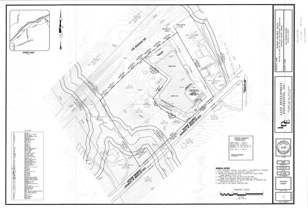
105
106 WINDER HIGHWAY RZC & SUP Printed: November 5, Feet FREEMANS MILL ROAD
107 R100MOD ION PARK L MOD OLD AUBURN ROAD R100MOD RA200 STILL ROAD RA WINDER HIGHWAY C2 R100 FREEMANS MILL ROAD RA200 R1200 R RZC & SUP Printed: R1100 November 5, 2013 C2 DACULA Feet
108 GWINNETT COUNTY DEPARTMENT OF PLANNING AND DEVELOPMENT REZONING AND SPECIAL USE PERMIT ANALYSIS CASE NUMBER :RZC ZONING CHANGE :NS TO O-I LOCATION :1100 BLOCK OF OLD TUCKER ROAD MAP NUMBER :R ACREAGE :0.89 ACRE SQUARE FEET :3,000 SQUARE FEET PROPOSED DEVELOPMENT :ADULT DAY CARE CENTER (REDUCTION IN BUFFERS) COMMISSION DISTRICT :(2) HOWARD CASE NUMBER :SUP ZONING :O-I (PROPOSED) LOCATION :1100 BLOCK OF OLD TUCKER ROAD MAP NUMBER :R ACREAGE :0.89 ACRE SQUARE FEET :3,000 SQUARE FEET PROPOSED DEVELOPMENT :ADULT DAY CARE CENTER COMMISSION DISTRICT :(2) HOWARD FUTURE DEVELOPMENT MAP: EXISTING/EMERGING SUBURBAN APPLICANT: JESSICA LANE C/O ANDERSEN, TATE & CARR 1960 SATELLITE BOULEVARD, SUITE 4000 DULUTH, GA CONTACT: MARIAN C. ADEIMY PHONE: OWNER: JESSICA LANE C/O ANDERSEN, TATE & CARR 1960 SATELLITE BOULEVARD, SUITE 4000 DULUTH, GA DEPARTMENT RECOMMENDATION: APPROVAL WITH CONDITIONS PROJECT DATA: The applicant requests to rezone a 0.89-acre parcel from NS (Neighborhood Shopping District) to O-I (Office-Institutional District) with a Special Use Permit, to allow an adult daycare center. The property is located on the north side of Old Tucker Road, west of its intersection with Rockbridge Road. The site is currently developed with a single-family residence, an accessory structure and associated parking and driveways.
109 RZC & SUP (AMc) The applicant proposes to utilize the existing single-family dwelling to provide daycare services for approximately adults. The applicant has indicated that the home was previously converted for office uses. There are two vehicular access points from Old Tucker Road, and 9 parking lot spaces are indicated on the submitted site plan. In lieu of the required 50-foot buffer, the site plan shows chain link and wood fencing along the northern property line, where the property abuts R-75 zoning. A building code compliance inspection has been conducted on the home and a report indicating the improvements necessary to bring the structure up to code for the proposed daycare use is attached (CIR ). ZONING HISTORY: In 1970, the subject property was zoned R-100 (Single Family Residence District). The property was rezoned to O-I (Office-Institutional District) in 1973, per an area-wide rezoning action. In 1985, the property was rezoned from O-I to NS, pursuant to RZ GROUNDWATER RECHARGE AREA: The subject property is not located within an identified Significant Groundwater Recharge Area. WETLANDS INVENTORY: The subject property does not contain areas, streams, and/or bodies of water depicted as wetlands on the U.S. Department of Interior, Fish, and Wildlife Service National Wetlands Inventory map on file with the Gwinnett Department of Planning and Development. OPEN SPACE AND GREENWAY MATER PLAN: No comment. DEVELOPMENT REVIEW SECTION COMMENTS: The Buffer, Landscape and Tree Ordinance requires a ten-foot wide landscape strip adjacent to all street rights-of-way for non-residential developments. The Buffer, Landscape and Tree Ordinance requires submittal and approval of a Tree Preservation and Replacement Plan prepared by a professional landscape architect prior to securing a Land Disturbance or Development permit. Section of the 1985 Zoning Resolution requires screening of dumpsters and loading/unloading facilities. Parking lots and interior driveways shall be designed in accordance with Section 1001 of the 1985 Zoning Resolution. 2
110 RZC & SUP (AMc) Parking spaces shall be provided at a ratio of one space per 300 to 400 square feet for daycare. Section 6.13 of the Development Regulations requires construction of five-foot wide sidewalks along all exterior roadways adjoining the project, and four-foot wide sidewalks adjacent to both sides of all interior public streets (excluding cul-de-sac turnarounds). The developer must submit detailed site development plans, including a landscape and tree preservation/replacement plan, for review and approval of the Development Division prior to any construction. The developer must obtain a Land Disturbance or Development Permit from the Development Division prior to any construction. Section of the Development Regulations requires submittal of a Storm Water Management Report for the project prior to obtaining a Land Disturbance or Development Permit. STORMWATER REVIEW SECTION COMMENTS: No comment. GWINNETT COUNTY DEPARTMENT OF TRANSPORTATION COMMENTS: Old Tucker Road is a Minor Collector and 30 feet of right-of-way is required from the centerline. GWINNETT COUNTY ENVIRONMENTAL HEALTH COMMENTS: Contact GCEHD regarding septic system requirements. GWINNETT COUNTY DEPARTMENT OF WATER RESOURCES COMMENTS: The available utility records show that the subject development is currently in the vicinity of a 12-inch water main located on the northern right-of-way of Old Tucker Road. Due to the uncontrollable variables, the Department of Water Resources makes no guarantees as to the minimum pressures or volumes available at a specific point within its system. Demands imposed by the proposed development may require reinforcements or extensions of existing water mains. Any cost associated with such required reinforcements or extensions will be the responsibility of the development and will not be provided by this department. The available utility records show that the subject development is currently in the vicinity of an 8-inch sanitary sewer main located approximately 315 feet south of the property. The subject development is located within the Mountain Park service area. There are currently no connection restrictions within this service area. Treatment capacity within this area is presently available on a first come - first serve basis. 3
111 RZC & SUP (AMc) Demands imposed by the proposed development may require reinforcements or extensions of existing sewer mains. Any cost associated with such required reinforcements or extensions will be the responsibility of the development and will not be provided by this department. Developer shall provide easements for future sewer connection to all locations designated by DWR during plan review. As-built information for this department is dependent upon outside entities to provide record drawings for the utilities. Therefore this department does not guarantee the accuracy of the information provided. Extensions of the water and/or sanitary sewer systems within the subject development must conform to this department s policies and Gwinnett County s ordinances. Proceeding design, construction, inspection, and final acceptance of the required utilities, service to these utilities would then become available under the applicable utility permit rate schedules. BUILDING CONSTRUCTION SECTION COMMENTS: Building Plan Review has no objections under the following conditions: 1. The applicant shall obtain a building code compliance inspection of the existing building by the Building Construction Section of Department of Planning and Development and shall comply with inspection results. 2. The applicant shall submit civil site drawings to Building Plan Review for review and approval. 3. The applicant shall submit plans which clearly indicate any new construction as proposed by the applicant and as required by compliance inspection report for review and approval by Building Plan Review. 4. Upon completion of plan review approvals, the applicant shall obtain a building permit for any required renovation work and achieve satisfactory field inspections for issuance of a Certificate of Occupancy. For assistance, you may contact this office at (678) Monday through Friday from the hours of 8:00 am to 5:00 pm. GWINNETT COUNTY FIRE SERVICES COMMENTS: Fire Plan Review has no objections to the above rezoning requests, under the following conditions: 1. Applicant submits civil drawings to Fire Plan Review for review and approval. 2. Applicant submits architectural drawings to Fire Plan Review for review and approval. 4
112 RZC & SUP (AMc) 3. Upon completion of plan review approvals, applicant successfully achieves a satisfactory Fire field inspection, for issuance of a Certificate of Occupancy - Business Operation. For assistance, you may contact this office at (678) , Monday through Friday, from the hours of 8:00 a.m. to 5:00 p.m. DEPARTMENT ANALYSIS: The subject 0.89-acre property is located on the north side of Old Tucker Road, west of its intersection with Rockbridge Road. The site is currently developed with a single-family residence, associated parking areas and driveways. The 2030 Unified Plan Future Development Map indicates the property is located within an Existing/Emerging Suburban Character Area, which encourages neighborhood-serving retail and commercial services at major intersections. The site is a peripheral part of the established commercial node surrounding the intersection of Five Forks-Trickum Road and Rockbridge Road, and therefore the requested use and zoning could be supported by the Unified Plan. The area is characterized by commercial and office uses surrounding the intersection of Five Forks-Trickum Road and Rockbridge Road, with residential development lying beyond the commercial node. Abutting the subject site to the north is property zoned R-75 (Single Family Residence District), which appears to house a business use. Across Old Tucker Road are single family residences zoned R-100 (Single Family Residence District) and a Kroger shopping center zoned C-2 (General Business District). Abutting the property to the east are lands zoned NS and O-I. Several homes in this area have been converted to office/commercial uses and, under the proposed O-I zoning, this property could continue to serve as a transition between the commercial node and the single family residential areas located to the north and west of the property. These nearby similar conversions to office uses and the property s location within a commercial node could give supporting grounds for the applicant s request. With appropriate conditions, the proposed O-I zoning and Special Use Permit could be compatible with neighboring uses, and consistent with the Unified Plan. Therefore, the Department recommends APPROVAL WITH CONDITIONS of this request. 5
113 RZC & SUP (AMc) PLANNING AND DEVELOPMENT DEPARTMENT RECOMMENDED CONDITIONS Approval as O-I with a Special Use Permit to allow an adult daycare center, subject to the following enumerated conditions: 1. To restrict the use of the property as follows: A. Professional office and accessory uses and structures, which may include an adult daycare center as a special use. The daycare shall be limited to no more than 12 persons, subject to applicable building and fire codes. B. Hours of operation shall be limited to between 6:00 a.m. and 8 p.m., Monday through Saturday. C. Prior to business occupancy, the site and building shall be brought up to all applicable codes through the issuance of development and/or building permits. 2. To satisfy the following site development considerations: A. Provide a 10-foot wide enhanced buffer adjacent to residentially-zoned properties. The buffer shall be enhanced where sparsely vegetated. B. Provide a ten-foot wide landscaped strip adjacent to all rights-of-way. C. Hours of dumpster pick-up shall be limited to between 7:00 a.m. and 7:00 p.m. D. Ground and wall signage shall be externally illuminated, and overall ground sign height shall not exceed 6 feet. E. Exterior lighting shall be contained in cut-off type luminaries, and directed so as not to shine directly into adjacent roadways or nearby properties. F. Peddlers and/or parking lot sales shall be prohibited. G. No temporary banners, streamers or roping decorated with flags, tinsel, or other similar materials shall be displayed, hung, or strung on the site. Yard and/or bandit signs, signwalkers and sign-twirlers shall be prohibited. H. Owner shall repair or repaint any graffiti or vandalism that occurs on the property within 72 hours. 6
114 RZC & SUP (AMc) PLANNING AND DEVELOPMENT DEPARTMENT RECOMMENDATIONS STANDARDS GOVERNING THE EXERCISE OF ZONING SUITABILITY OF USE Office-Institutional zoning could be suitable at this location in view of the adjacent O-I zoning and C-2 zoning across Old Tucker Road, as well as the numerous other commercial uses at this commercial node along Five Forks-Trickum Road and Rockbridge Road. ADVERSE IMPACTS With the recommended conditions, minimal adverse impacts would be anticipated from this request. REASONABLE ECONOMIC USE AS ZONED The subject property has a reasonable economic use as currently zoned. IMPACT ON PUBLIC FACILITIES A minor increase in impacts on public facilities could be expected in the form of traffic and utility demand. CONFORMITY WITH POLICIES The property is a part of the commercial node surrounding the intersection of Five Forks Trickum Road and Rockbridge Road. Therefore, the requested rezoning could be supported by the Unified Plan, which encourages neighborhood-serving retail and commercial services at major intersections. CONDITIONS AFFECTING ZONING Nearby similar conversions of residences to commercial and office uses, and the property s location within a commercial node, could give supporting grounds for the applicant s request. 7
115
116

117
118
119

120 446 West Crogan Street, Ste. 150, Lawrenceville, Ga PHONE: COMPLIANCE INSPECTION REPORT CASE NUMBER: CIR RECEIVED DATE: 11/5/2013 APPLICATION NAME: JESSICA LANE APPLICATION ADDRESS: 1180 OLD TUCKER RD, STONE MOUNTAIN, GA APPLICANT: Jessica Lane 1180 Old Tucker Road Stone Mountain, GA REQUEST TYPE: Existing Building Compliance Report NFPA OCCUPANCY: CURRENT OCCUPANCY USE: R-4 (IBC) Residential PROPOSED OCCUPANCY USE: B (IBC) Business DEVELOPMENT TYPE: Other CONSTRUCTION TYPE: (IBC) TYPE VB UNSPRINKLERED The following is the code compliance inspection report for the proposed occupancy and use. If you have any questions, please contact Building Plan Review at Construction drawings must be submitted to Building Plan Review and Fire Plan Review for code compliance review and authorization of a building permit before any construction work or repair work is performed. ITEM COMMENT INSPECTOR STATUS Electrical Code Compliance 11/12/2013 The electrical system for the proposed occupancy is suitable for intended use. 11/12/2013 Ground fault circuit interrupter (GFCI) in bathroom, kitchen, and outside receptacles NEC old split buse electrical panel with main breaker inside, 100AMP. has 60 AMP sub off meter going to storage house out behind main house. as well as other eletrical issues. pbtain all required permits and plans and get required inspections. NEC all GFIC required recp. bathrooms, kitchen, outside will need to be added 11/12/2013 Location of service disconnect. NEC panel more then 3 feet from meter no main disconnect 11/12/2013 Service equipment - Fault current rating. Johnny Lyons Johnny Lyons Johnny Lyons Fail Fail Fail NEC Johnny Lyons Fail 11/12/2013 Service equipment - Load calculation. NEC 220 only 100 AMp service Johnny Lyons Fail 11/12/2013 Approved covers on junction boxes and accessible. 11/12/2013 Junction boxes - Correct size for box volume. 11/12/2013 Conductors - Correct size for overcurrent device. NEC 314 Johnny Lyons Fail NEC Johnny Lyons Fail NEC 310 several wire splice no box or cover just tape as well as open recp Johnny Lyons 11/12/2013 Physical condition of conductors. NEC 310 Johnny Lyons Fail 11/12/2013 Sub-Panels - Location of panels NEC Johnny Lyons Fail 11/12/2013 Sub-Panels - working clearance in front of panels. Fail NEC Johnny Lyons Fail 11/12/2013 Sub-Panels - Illumination of panels. NEC (d) Johnny Lyons Fail 11/12/2013 Overcurrent devices - Correct type per panel manufacturer. 11/12/2013 Number of overcurrent devices for panel. NEC Johnny Lyons Fail NEC Johnny Lyons Fail
121 ITEM COMMENT INSPECTOR STATUS Electrical Code Compliance 11/12/2013 Grounding type receptacles. NEC 406 Johnny Lyons Pass 11/12/2013 Required location for receptacles. NEC 210 Johnny Lyons Pass 11/12/2013 Required location for lights and switches. 11/12/2013 Grounding to metal water pipe, building steel, ground rods. 11/12/2013 Working clearance in front of equipment. 11/12/2013 Service equipment - Illumination of service and/or panels. 11/12/2013 Occupant to have access to service equipment. 11/12/2013 Proper equipment grounding conductor size. 11/12/2013 Disconnects for appliances and HVAC equipment -Required locations and accessible. Fire Daycare Inspection NEC 210 Johnny Lyons Pass NEC Johnny Lyons Pass NEC Johnny Lyons Pass NEC (d) Johnny Lyons Pass NEC (c) Johnny Lyons Pass NEC Johnny Lyons Pass NEC NEC /12/2013 Exterior: Accessible Parking Provided Parking lot striping and car/van accessible handicapped signage shall be installed in accordance with the ADA Code. 11/12/2013 Interior: Door Hardware Works Properly The deadbolts on the (2) required Exit doors shall be removed. All door hardware within this facility shall be single locking, have lever handled hardware and be capable of being unlocked from the interior side, with no special knowledge required. ie: bathrooms, closets and store rooms. Johnny Lyons Charles Anderson Charles Anderson Pass Fail Fail This is required of all Day Care Occupancies and Business Occupancies. 11/12/2013 Interior: Escape Routes Posted Evacuation routes shall be posted in all rooms of an Adult Day Care facility. Not required in a business occupancy. 11/12/2013 Interior: Fire Drill Records Maintained Adult Day Care Occupancies shall keep a Fire Drill Log. Drills shall be conducted monthly ane evacuation times recorded. 11/12/2013 Interior: Accessible Restroom Provided Unisex Handicapped bathroom signage shall be provided. 11/12/2013 Fire Protection Systems: Exit Signs (2) exit signs shall operate on normal electrical power and emergency battery power. Charles Anderson Charles Anderson Charles Anderson Charles Anderson Fail Fail Fail Fail All occupancy types. 11/12/2013 Fire Protection Systems: Emergency Lights (2) emergency lights shall operate on normal electrical power and emergency battery power. Charles Anderson Fail All occupancy types. 11/12/2013 Fire Protection Systems: Extinguisher Serviced & Tagged A fire extinguisher with a current inspection tag shall be provided by a licensed fire extinguishing company. The extinguisher shall be mounted at 48" above the floor to the top of the handle. Charles Anderson Fail
122 ITEM COMMENT INSPECTOR STATUS Fire Daycare Inspection 11/12/2013 Fire Protection Systems: Smoke Detectors Operate Properly An Adult Day care (6 or less occupants) facility will require inter-connected smoke detection in each room with the exception of the Kitchen (install a heat detector). So that if one detector is activated, all will sound. An Adult Day Care facility with 7 or more clients will require a complete fire alarm system in accordance with NFPA 72, the National Fire Alarm Code. Charles Anderson Fail A Business Occupancy at this location requires none of the above. 11/12/2013 Fire Protection Systems: Kitchen Hood System Service Any Business or Adult Day Care Occupancy will be required to have a Kitchen Hood Fire Suppression System above the range. Charles Anderson Fail The kitchen hood shall be vented to the outside. 11/12/2013 Fire Protection Systems: Sprinkler System Service Food warming via a Microwave Oven is allowed. Remove 4 burner range and vent hood. Business Occupancies and Adult Day Care Occupancies (Less than 6 clients), do not require a sprinkler system. Charles Anderson Fail An Adult Day Care Occupancy with 7 or more clients requires a building fire sprinkler system in accordance with NFPA 13 and /12/2013 Miscellanous: This is a cursory fire inspection report and may not cover all requirements needed to occupy this building. A floor plan and parking plan of the building will need to be submitted to the Gwinnett County Fire Planning Department for review and approval. Charles Anderson 11/12/2013 Exterior: Ramps/Landings Charles Anderson Pass 11/12/2013 Exterior: Exit Discharge leads to Public Way Charles Anderson 11/12/2013 Exterior: Address is Visible Charles Anderson Pass 11/12/2013 Mechanical/Storage Rooms: Electrical Rooms Free of Excess Combustibles 11/12/2013 Mechanical/Storage Rooms: Washer/Dryer Area Free of Excess Combustibles 11/12/2013 Mechanical/Storage Rooms: Furnance Rooms Free of Excess Combustibles 11/12/2013 Mechanical/Storage Rooms: All Penetrations Sealed 11/12/2013 Mechanical/Storage Rooms: Rooms are Secured 11/12/2013 Mechanical/Storage Rooms: Electrical Panels Clearly Marked Charles Anderson Charles Anderson Charles Anderson Charles Anderson Charles Anderson Charles Anderson 11/12/2013 Interior: Exit Ways Clear & Maintained Charles Anderson Pass 11/12/2013 Interior: Doors Operate Properly Charles Anderson Pass 11/12/2013 Interior: Temp. Ext. Cords of Proper Type Charles Anderson Fail Pass Pass Pass Pass Pass Pass Pass Pass
123 ITEM COMMENT INSPECTOR STATUS Mechanical Code Compliance 11/12/2013 The mechanical system for the proposed occupancy is suitable for intended use. 11/12/2013 Ducts and duct sytems - Joints, seams, and connections. Ranch house with crawlspace ,000 btu Trane horizanol furance under house with 3 tons Trane cool unit outside. several minor issues will need to be adressed. will need to have required plans and obtain permit and get all inspections as needed for space 2 supply apart under kitchen area that will need to be repaired Johnny Lyons Johnny Lyons 11/12/2013 Fresh air system - allowable material. Johnny Lyons Fail 11/12/2013 Fresh air system - Location on intakes. Johnny Lyons Fail 11/12/2013 Fresh air system - ASHRAE air systems. 11/12/2013 Exhaust systems - Bath fan vents and termination. install as required per table mechanical code all bathroom exhuast to be 75 CFM and vented to the ouside per code 11/12/2013 Grease Hoods - Allowable material. has a residential kitchen stated would be using to cook for occupenants will need to get with fire on a fire superation system as they require Johnny Lyons Johnny Lyons Johnny Lyons 11/12/2013 Grease Hoods - Outside make-up air. Johnny Lyons Fail 11/12/2013 Grease Hoods - Duct system for hood and make-up air for hood. 11/12/2013 Grease Hoods - Cleanouts and hood labeling. Johnny Lyons Johnny Lyons 11/12/2013 Grease Hoods - Hood duct support. Johnny Lyons Fail 11/12/2013 Grease Hoods - Automatic gas shutdown control. 11/12/2013 Grease Hoods - Duct termination and separation. 11/12/2013 Fuel gas piping - Shut-off valves and approved locations. 11/12/2013 Ducts and duct sytems - Allowable materials. gas stove will probly need ansle valve to shut off gas with fire suroeration system as required by fire Johnny Lyons Johnny Lyons Johnny Lyons Johnny Lyons 11/12/2013 Duct support. Johnny Lyons Pass 11/12/2013 Duct insulation. Johnny Lyons Pass 11/12/2013 Ducts and duct sytems - complies with Georgia State Energy Code. 11/12/2013 Combustion and ventilation air - Allowable material. 11/12/2013 Combustion and ventilation air - Capacity for space. 11/12/2013 Combustion and ventilation air - Termination. Johnny Lyons Johnny Lyons Johnny Lyons Johnny Lyons 11/12/2013 Equipment - Location. Johnny Lyons Pass 11/12/2013 Equipment - Accessibility. Johnny Lyons Pass 11/12/2013 Equipment - Clearance. Johnny Lyons Pass 11/12/2013 Equipment - Support. Johnny Lyons Pass 11/12/2013 Complies with Georgia State Energy Code 11/12/2013 Separation ventilation system for incompatible material - Flammable vapors. 11/12/2013 Separation ventilation system for incompatible material - Corrosive vapors. 11/12/2013 Separation ventilation system for incompatible material - Other. 11/12/2013 Chimneys and vents systems - Allowable materials. Johnny Lyons Johnny Lyons Johnny Lyons Johnny Lyons Johnny Lyons Fail Fail Fail Fail Fail Fail Fail Fail Fail Fail Pass Pass Pass Pass Pass Pass Pass Pass Pass Pass
124 ITEM COMMENT INSPECTOR STATUS Mechanical Code Compliance 11/12/2013 Chimneys and vents systems - Capacity. 11/12/2013 Chimneys and vents systems - Location. 11/12/2013 Chimneys and vents systems - Clearance. 11/12/2013 Chimneys and vents systems - Fire stops. 11/12/2013 Chimneys and vents systems - Termination. Johnny Lyons Johnny Lyons Johnny Lyons Johnny Lyons Johnny Lyons 11/12/2013 Fuel gas piping - Allowable material. Johnny Lyons Pass 11/12/2013 Fuel gas piping - Location. Johnny Lyons Pass 11/12/2013 Fuel gas piping - Joints. Johnny Lyons Pass 11/12/2013 Fuel gas piping - Support. Johnny Lyons Pass 11/12/2013 Fuel gas piping - Concealed gas line. Johnny Lyons Pass 11/12/2013 Fuel gas piping - Underground - in slab install. 11/12/2013 Condensate drains piping and termination. Johnny Lyons Johnny Lyons 11/12/2013 Refrigeration system - Material. Johnny Lyons Pass 11/12/2013 Refrigeration system - Location Johnny Lyons Pass 11/12/2013 Refrigeration system - Joints and refrigerant containing part in plenum. Johnny Lyons 11/12/2013 Refrigeration system - Piping insulation. Johnny Lyons Pass Plumbing Code Compliance 11/12/2013 The plumbing system for the proposed occupancy is suitable for intended use. 11/12/2013 Water heaters - install thermal expansion device. 11/12/2013 This occupancy requires drinking fountains to be installed. 11/12/2013 Provide separate toilet rooms for male and female. 11/12/2013 Change all water closets to elongated with open front seats. 11/12/2013 Install double check valve assembly and certify device. 11/12/2013 Install pressure reducing valve in main water service. 11/12/2013 Water heaters - Provide combustion air from outside. 11/12/2013 Water heaters - Provide 3/4 T&P relief line using approved pipe. 11/12/2013 Water heaters - Install vacuum relief valve (bottom feed heaters only). 11/12/2013 Water heaters - Repair or replace vent with approved vent pipe. Pass Pass Pass Pass Pass Pass Pass Pass seveeral minor plumbing issues. Johnny Lyons Fail IPC Johnny Lyons Fail IPC Johnny Lyons Fail IPC Johnny Lyons Fail IPC Johnny Lyons Fail IPC Johnny Lyons Fail IPC Johnny Lyons Fail IPC electric 50 gallaon water heater, under crawlspace under kitchen area Johnny Lyons Pass IPC Johnny Lyons Pass IPC Johnny Lyons Pass Johnny Lyons 11/12/2013 Repair or replace water heater. IPC Johnny Lyons Pass 11/12/2013 Replace/repair water distribution pipe to comply with 2006 IPC. 11/12/2013 Replace/repair drain waste vent system to comply with 2006 IPC. 11/12/2013 Install vacuum brakers on all hose bibbs. Structural Code Compliance 11/12/2013 Wood grades, spans, floor joist, ceiling and rafters. Pass IPC Johnny Lyons Pass IPC Johnny Lyons Pass IPC Johnny Lyons Pass IBC rd party engineer need to verify floor load Joe Martin Fail
125 ITEM COMMENT INSPECTOR STATUS Structural Code Compliance 11/12/2013 Insulation, flamespread. IBC 719 can not verify Joe Martin 11/12/2013 Insualtion in attic. IECC 502 Joe Martin Fail 11/12/2013 Insualtion in crawlspace. IECC 502no insulation Joe Martin Fail 11/12/2013 Fire resistance rated construction requirements Fail IBC 701unable to verify Joe Martin Fail 11/12/2013 Tempered glass for doors and windows. IBC 2406 no tempered glass Joe Martin Fail

126 AVA L AN E 6-97 E COURT TALL PI N OAKHILL COURT SEVILLE LANE SHADOW VIE W DRIVE HODGES WAY M O UNTAINBRO OKE CIRCLE CRESTWOOD DRIVE JORDAN ROAD OLD TUCKER ROAD STONE COURT NOBLETT ROAD S U MMER COVE DRIVE 6-95 CRESTLAND COURT BEECHWOOD DRIVE MOUNTAIN PARK AQUATIC CENTER & ACTIVITY BRADY DRIVE MELANIE COURT ROCKY HILL DRIVE LASSITER DRIVE ROCKBRIDGE ROAD LANFORD CIRCLE LANFORD DRIVE BROWN ROAD BRITT WAY TURNER ROAD FIVE FORKS TRICKUM ROAD EVELYN LANE BARRINGTON ROAD JENNIE LANE SPRING MILL DRIVE ADDISON TRAIL SCENIC WAY PENDALE D RIVE 6-79 GARNER ROAD SHEPPARD DRIVE CANDLEBERRY DRIVE 6-93 APOLLO LANE DENMARK DRIVE DeKalb County BOWERS ROAD 6-78 PINE CIRCLE POPULAR DRIVE SPRING VALLEY LANE COUNTRY LAKE COURT RZC & SUP Printed: November 5, Feet RODNEY LANE BARON COURT PINE STREET WOODS CIRCLE VILLAGE VIEW LANE FRANCES AVENUE 6-77 BROWNLEE ROAD 6-76
127


128 OLD TUCKER ROAD BEECHWOOD DRIVE RZC & SUP Printed: November 5, Feet BRADY DRIVE


129 CRESTWOOD DRIVE CRESTLAND COURT NELSON POINTE DRIVE OI C1 MOUNTAIN PARK AQUATIC CENTER & ACTIVITY 6-94 PINE VIEW ROAD R100 BROWN ROAD BARRINGTON BRITT WAY E COURT 6-95 OI R75 OI OLD TUCKER ROAD OODS COURT NOBLETT ROAD R100 BEECHWOOD DRIVE NS MELANIE COURT OI ROCKBRIDGE ROAD OLD TUCKER LANE C2 FIVE FORKS TRICKUM ROAD 6-79 TURNER ROAD OD COURT 6-78 TARA COURT BRADY DRIVE R100 RZC & SUP SCARLETT COURT Printed: November 5, Feet BOWERS ROAD OI SPRING VALLEY LANE CIRCLE C1
130 GWINNETT COUNTY DEPARTMENT OF PLANNING AND DEVELOPMENT REZONING ANALYSIS CASE NUMBER :RZM ZONING CHANGE :C-2 & O-I TO RM-13 LOCATION :2700 BLOCK OF LOGANVILLE HIGHWAY MAP NUMBER :R ACREAGE :30.35 ACRES PROPOSED DEVELOPMENT :APARTMENTS UNITS :262 UNITS COMMISSION DISTRICT :(3) HUNTER FUTURE DEVELOPMENT MAP: CORRIDOR MIXED USE APPLICANT: DAVIS DEVELOPMENT 1050 EAGLES LANDING PARKWAY, SUITE 300 STOCKBRIDGE, GA CONTACT: HEATH HAWKINS PHONE: OWNER: RES-GA LTV, LLC 750 HAMMOND DRIVE, SUITE 300 ATLANTA, GA DEPARTMENT RECOMMENDATION: DENIAL PROJECT DATA: The applicant has requested rezoning of a acre parcel from C-2 (General Business District) and O-I (Office-Institutional District) to RM-13 (Multi-Family Residence District) for the construction of a 262 unit apartment complex. The property is located on the southwest side of Loganville Highway, between Cooper Road and Oak Grove Road. The property is partially wooded, with the majority of the site being open fields. It is noted that the property is located within the Grayson/Georgia Highway 20 Overlay District and is subject to those requirements. The submitted site plan proposes development of twenty-five apartment buildings comprising 262 units, which would yield a gross density of 8.63 units per acre. Due to the presence of a power line easement at the southern end of the tract, the net density for the project would be 8.77 units per acre. The mix of rental units would include 100 one-bedroom units, 122 two-bedroom units and 40 three-bedroom units, ranging in size from 678 square feet to 1,467 square feet. Direct garage access would be provided for approximately 84% of the units. Architectural information was not submitted for the proposed apartment buildings. A clubhouse/leasing office and pool would be constructed at the site s proposed entrance.
131 RZM (AMc) Sole access to the apartment complex would be from Loganville Highway, with a potential future driveway connection to the adjacent shopping center to the north. A 50-foot wide building setback is proposed along the right-of-way of Loganville Highway. A 100-foot buffer is proposed along the rear property line adjacent to single family residential homes, which would include berms and evergreen screen planting as indicated on the site plan. A berm and plantings is also shown in the power line easement to provide screening for the neighborhood to the south. ZONING HISTORY: In 1970, the subject property was zoned RA-200 (Agriculture-Residence District). The property was rezoned to R-100 (Single Family Residence District) per an areawide rezoning in In 1974, the property was rezoned back to RA-200, pursuant to RZ In 2000, the property was rezoned to C-2 and O-I, pursuant to RZ and RZ ; a Special Use Permit for an assisted living facility on the O-I portion of the property was also granted, pursuant to SUP GROUNDWATER RECHARGE AREA: The subject property is not located within an identified Significant Groundwater Recharge Area. WETLANDS INVENTORY: The subject property does not contain areas, streams, and/or bodies of water depicted as wetlands on the U.S. Department of Interior, Fish, and Wildlife Service National Wetlands Inventory map on file with the Gwinnett Department of Planning and Development. OPEN SPACE AND GREENWAY MASTER PLAN: No comment. DEVELOPMENT REVIEW SECTION COMMENTS: The Buffer, Landscape and Tree Ordinance requires a ten-foot wide landscape strip along classified roadways. The Buffer, Landscape and Tree Ordinance requires submittal and approval of a Tree Preservation and Replacement Plan prepared by a professional landscape architect prior to securing a Land Disturbance or Development permit. Section of the 1985 Zoning Resolution requires screening of dumpsters and loading/unloading facilities. Parking lots and interior driveways shall be designed in accordance with Section 1001 of the 1985 Zoning Resolution. 2
132 RZM (AMc) Section and/or of the Development Regulations requires a 200-foot deceleration lane with a 50-foot taper at each project entrance that proposes access to a Minor Collection Street or Major Thoroughfare. Right-of-way dedication to accommodate the deceleration lane and an 11- foot shoulder is also required. Reduction in length of a deceleration lane requires approval of a Modification by the Development Division; elimination of a deceleration lane requires approval of a Waiver by the Board of Commissioners. Project access and required improvements along State routes or U.S. Highways (i.e., number and design of driveways, deceleration lanes, median breaks, etc.) will be subject to review and approval of the Georgia Department of Transportation. Section 6.13 of the Development Regulations requires construction of five-foot wide sidewalks along all exterior roadways adjoining the project, and four-foot wide sidewalks adjacent to both sides of all interior public streets (excluding cul-de-sac turnarounds). A 50-foot building setback is required from the right-of-way of GA Hwy. 20. Section of the 1985 Zoning Resolution requires an additional five-foot setback for all structures (parking lots, driveways, detention ponds, retaining walls, etc.) adjacent to required buffers. The developer must submit detailed site development plans, including a landscape and tree preservation/replacement plan, for review and approval of the Development Division prior to any construction. Section of the Development Regulations requires submittal of a Storm Water Management Report for the project prior to obtaining a Land Disturbance or Development Permit. Section b of the Floodplain Management Ordinance requires that the lowest floor, including the basement, of all residential buildings be constructed at an elevation of at least three feet above the 100-year floodplain. This project lies within an Activity Center/Corridor Overlay District, and is subject to all requirements set forth in Section 1315 of the Gwinnett County 1985 Zoning Resolution. STORMWATER REVIEW SECTION COMMENTS: No comment. GWINNETT COUNTY DEPARTMENT OF TRANSPORTATION COMMENTS: Loganville Highway is a State Route and Georgia D.O.T. right-of-way requirements govern. Coordinate with the Georgia D.O.T. regarding access. 3
133 RZM (AMc) GWINNETT COUNTY ENVIRONMENTAL HEALTH COMMENTS: No comment. GWINNETT COUNTY DEPARTMENT OF WATER RESOURCES COMMENTS: The available utility records show that the subject development is currently in the vicinity of a 12-inch water main located on the southern right-of-way of Loganville Highway. Due to the uncontrollable variables, the Department of Water Resources makes no guarantees as to the minimum pressures or volumes available at a specific point within its system. Demands imposed by the proposed development may require reinforcements or extensions of existing water mains. Any cost associated with such required reinforcements or extensions will be the responsibility of the development and will not be provided by this department. The available utility records show that the subject development is currently in the vicinity of an 8-inch sanitary sewer main located on the property. The subject development is located within the Pole Bridge/Dekalb service area. There are currently no connection restrictions within this service area. Treatment capacity within this area is presently available on a first come - first serve basis. Demands imposed by the proposed development may require reinforcements or extensions of existing sewer mains. Any cost associated with such required reinforcements or extensions will be the responsibility of the development and will not be provided by this department. Developer shall provide easements for future sewer connection to all locations designated by DWR during plan review. As-built information for this department is dependent upon outside entities to provide record drawings for the utilities. Therefore this department does not guarantee the accuracy of the information provided. Extensions of the water and/or sanitary sewer systems within the subject development must conform to this department s policies and Gwinnett County s ordinances. Proceeding design, construction, inspection, and final acceptance of the required utilities, service to these utilities would then become available under the applicable utility permit rate schedules. BUILDING CONSTRUCTION SECTION COMMENTS: Building Plan Review has no objections under the following conditions: 1. The applicant shall submit civil site drawings to Building Plan Review for review and approval. 2. The applicant shall submit architectural, structural, mechanical, electrical and plumbing drawings for each building for review and approval by Building Plan Review. 4
134 RZM (AMc) 3. Each building shall comply with the height and area limitations of Table 503 and the fire resistive and horizontal separation requirements of Table 601 and 602 of the 2006 International Building Code with Georgia state amendments based on occupancy group classification, type of construction, and location of each building from property lines and other buildings. 4. Architectural design of the proposed building shall incorporate the requirements of the Activity Center/Corridor Overlay District, Section 1315 of the 1985 Zoning Resolution of Gwinnett County. 5. Upon completion of plan review approvals, the applicant shall obtain a building permit for each building and achieve satisfactory field inspections for issuance of a Certificate of Occupancy. For assistance, you may contact this office at (678) Monday through Friday from the hours of 8:00 a.m. to 5:00 p.m. GWINNETT COUNTY FIRE SERVICES COMMENTS: Fire Plan Review has no objections to the above rezoning requests, under the following conditions: 1. Applicant submits civil drawings to Fire Plan Review for review and approval. 2. Applicant submits architectural drawings to Fire Plan Review for review and approval. 3. Upon completion of plan review approvals, applicant successfully achieves a satisfactory Fire field inspection, for issuance of a Certificate of Occupancy - Business Operation. For assistance, you may contact this office at (678) , Monday through Friday, from the hours of 8:00 a.m. to 5:00 p.m. DEPARTMENT ANALYSIS: The subject property is a acre parcel located on the southwest side of Loganville Highway just south of its intersection with Cooper Road. The property is partially wooded, and a large portion of the site is an open grass field. Acknowledging the subject property s location adjacent to the developed commercial node surrounding the Loganville Highway and Cooper/Ozora Road intersection, the 2030 Unified Plan Future Development Map identifies the site as being part of the Corridor Mixed-Use Character Area. Uses for designated nodes in this Character Area are encouraged to be mixed-use projects, focused primarily on employment-based development, where the dominant uses are non-residential. Residential components are to be integrated into the mixed-use project, and not be the sole or primary use, as proposed in this instance. As the requested stand-alone 5
135 RZM (AMc) apartment complex would not be integrated into mixed-use buildings, the proposal may not be consistent with policies of the Unified Plan. This segment of Loganville Highway is characterized by the established commercial node, with low-density single-family uses in the outlying areas. Northwest of the property is a Publix shopping center, zoned C-2. Also developed at the Cooper/Ozora Road and Loganville Highway intersection is additional retail uses including restaurants, convenience stores and a pharmacy. To the east and south along Loganville Highway are single-family subdivisions and homes on acreage. Adjacent to the west and south of the property are the Meadow Gate and Wildwood at Meadowgate subdivisions, zoned R-75 and R-75 Modified respectively. Although a residential use for the site could be suitable, the area is developed exclusively with detached single-family homes, and there is no precedent for RM-13 zoning in the area. As such, the Department cannot support the requested rezoning. In conclusion, the proposed garden-style apartment complex may not be consistent with the intent of the Unified Plan, which recommends that residential components of mixed-use developments be integrated with office/commercial activity. Additionally, the requested RM-13 zoning is out of character with the historical zoning and development patterns of the area. Given these factors, the Department of Planning and Development recommends DENIAL. 6
136 RZM (AMc) PLANNING AND DEVELOPMENT DEPARTMENT RECOMMENDED CONDITIONS NOTE: The following conditions are provided as a guide should the Board of Commissioners choose to approve the petition. Approval as RM-13 for a multifamily apartment development, subject to the following enumerated conditions: 1. To restrict the use of the property as follows: A. Multifamily residential dwellings and accessory uses and structures. B. The development shall be a gated community. C. Buildings shall be constructed primarily of brick or stacked stone on all sides. Stucco and fiber-cement siding/shake may be used as accent building materials. Building elevations shall be subject to review and approval by the Director of Planning and Development. D. Garages shall be provided for a minimum of 75% of the units. E. Abide by the applicable requirements of Section 1315, Activity Center Corridor Overlay District. This shall not preclude a variance application. 2. To satisfy the following site development considerations: A. Provide buffers, berms and evergreen plantings adjacent to residentially-zoned properties to the south and west as depicted on the submitted site plan. Buffer width, design and plantings shall be subject to review and approval of the Director of Planning and Development prior to the issuance of a development permit. B. Provide a 50-foot wide landscaped setback along Loganville Highway. The landscaped setback shall include a decorative fence or wall and entrance monument(s). Landscaping, fence/wall and entrance monument design shall be subject to review and approval of the Director of Planning and Development prior to the issuance of a development permit. C. Ground signage shall be limited to monument type sign(s) with a minimum two-foot high brick or stacked stone base. Ground sign(s) shall not exceed 8 feet in height. D. Dumpsters/trash compactors shall be screened by a 100% opaque brick wall. E. No temporary banners, streamers or roping decorated with flags, tinsel, or other similar material shall be displayed, hung, or strung on the site. No decorative balloons or hot-air balloons shall be displayed on the site. Yard and/or bandit signs, sign-walkers and signtwirlers shall be prohibited. 7
137 RZM (AMc) F. The property owner shall repaint or repair any graffiti or vandalism that occurs on the property within 72 hours. 8
138 SUITABILITY OF USE RZM (AMc) PLANNING AND DEVELOPMENT DEPARTMENT RECOMMENDATIONS STANDARDS GOVERNING EXERCISE OF ZONING The subject site is located at a commercial node and rezoning the property to an apartment use may not be appropriate given that residential development in the area is uniformly single-family homes and subdivisions. ADVERSE IMPACTS The construction of multi-family apartments on the property could impact the existing single family uses adjacent to the property, and the single family residential uses along this segment of Loganville Highway, through the introduction of an incompatible land use. Approval of this rezoning could also establish a precedent for additional multifamily requests along the corridor. REASONABLE ECONOMIC USE AS ZONED The property has a reasonable economic use as currently zoned. IMPACTS ON PUBLIC FACILITIES An increase in utility demand, traffic, stormwater runoff and the number of school-aged children could be anticipated from this request. CONFORMITY WITH POLICIES The proposed garden-style apartment complex may not be consistent with the intent of the Unified Plan, which recommends that residential components of mixed-use developments be integrated with commercial activity. As the proposed stand-alone apartment complex would not be integrated into mixed-use buildings, the proposal may not be consistent with policies of the Unified Plan. CONDITIONS AFFECTING ZONING If the property were to develop with one specific use, it may be more appropriately developed as commercial since the property is located at a commercial node. The existing C-2 and O-I zoning appears to be a more appropriate use at this established commercial node. 9
139
140
141

142
143
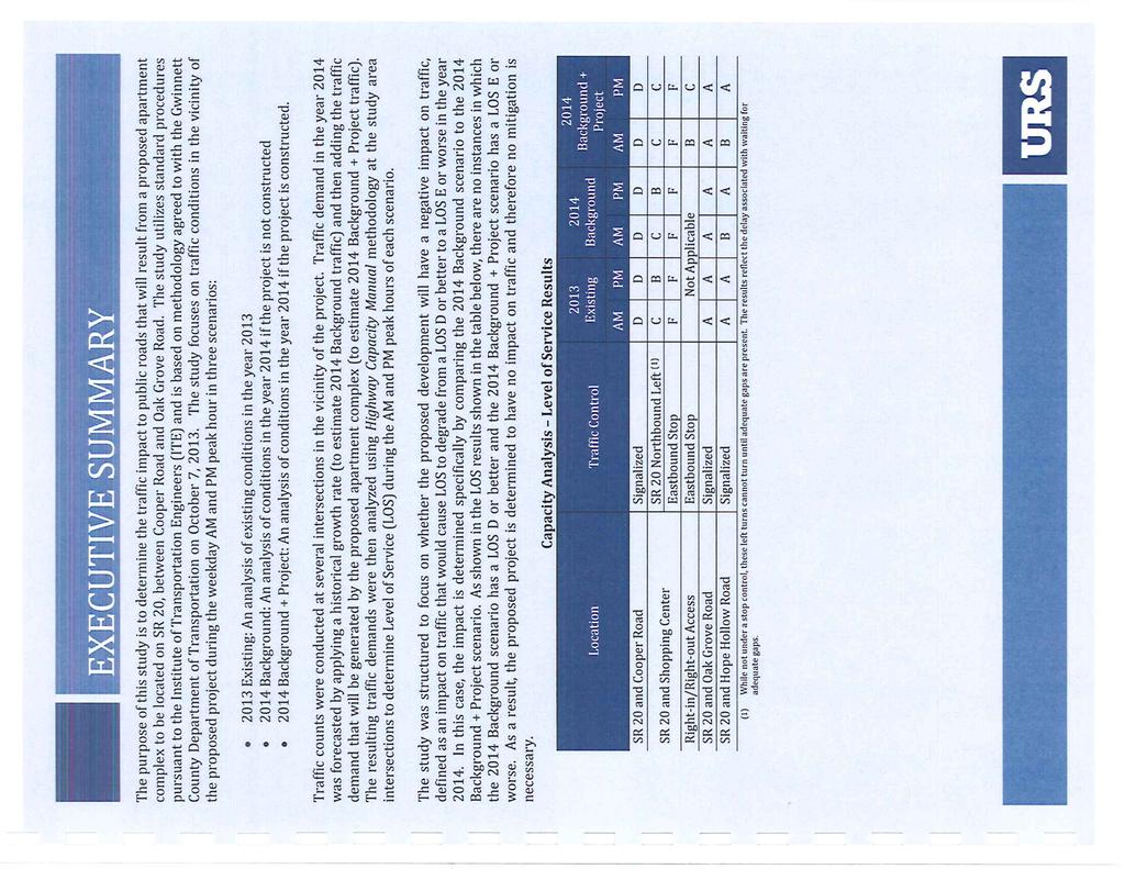
144

145

146
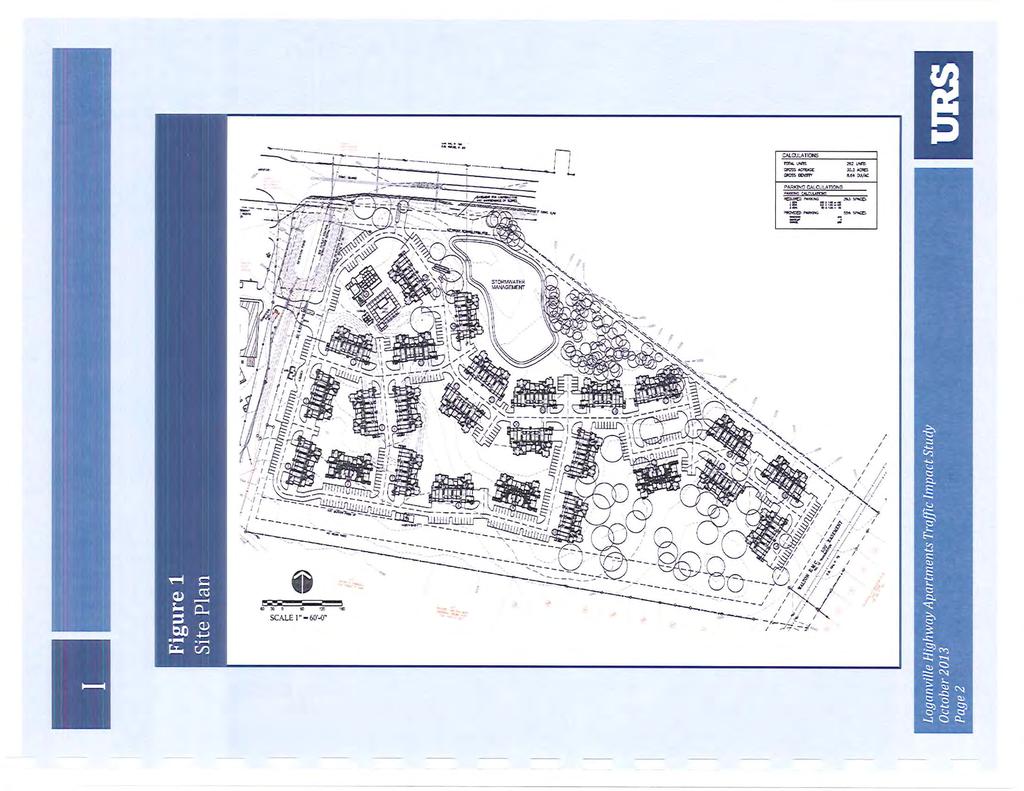
147

148

149
150
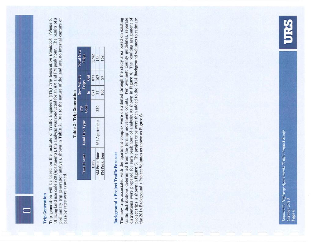
151
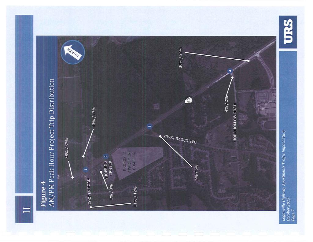
152
153
154
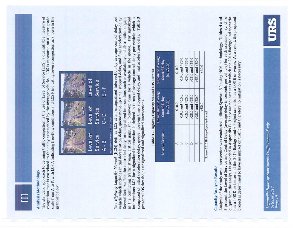
155
156

157
158 Residential Rezoning Impact on Local Schools Prepared for Gwinnett County, January 2014 Agenda Case # Schools Current Projections Proposed Zoning Approximate additional Student Forecast Capacity Over/Under Forecast Capacity Over/Under Forecast Capacity Over/Under Projections from Proposed Developments RZM South Gwinnett HS , , , Grace Snell MS , , , Rosebud ES , , , RZM Collins Hill HS , , , Creekland MS , , , Rock Springs ES 842 1, , , RZR Parkview HS , , , Trickum MS , , , Knight ES Current projections do not include new developments GCPS Planning Department /11/2013
159 5-135 CHANCE LANE CORBIN O AK RIDGE TYL E R BAY LANE GRAYSON MOON ROAD M I DDLETO N PLA C E PATRICIA TERRACE LIVINGSTON COURT BAY CREST LANE MOON ROAD OZORA ROAD WHIT E ROSE DRIVE TULLIS COVE DRIVE CADITZ LANE CAMP M ITCHE LL ROAD MADISON PARK DRIVE MCKENZIE GRACE LANE BAY CREEK PARK MEADOW GATE WAY WARM SPRINGS COURT COOPER ROAD GRAYMIST LANE COOPE R WOOD S LANE HOPE HOLLOW ROAD BLUE CREEK LANE WILD BARLEY WAY CAIN ROAD LACEY OAK LANE LOGANVILLE HIGHWAY LANGLEY ROAD ROLLING DOWNS WAY COOPER WO ODS DRIVE RZM LANGLEY CREEK DRIVE Printed: November 5, 2013 HOPE HOLLOW LANE TURNER ROAD HOLLOWSTONE DRIVE Feet BLUE CREEK PATH BEECH HOLLOW TRAIL SWEET BASIL LANE OAK GROVE ROAD BATTLEMENT CIRCLE VINES GARDENS CHAMPIONS WAY 5-163

160
161 OAK GROVE ROAD LOGANVILLE HIGHWAY MEADOW GATE COURT RZM GRAYMIST LANE Printed: November 5, 2013 MEADOW GATE WAY Feet BLUESTEM PATH BLUE CREEK LANE
162 C2 R100 OZORA ROAD OI R100CSO GRAYSON C C C2 COOPER ROAD R100 MEADOW GATE WAY R100 R C2 MEADOW GATE COURT RA200 OI OAK GROVE ROAD R75 LOGANVILLE HIGHWAY RA BLUESTEM PATH GRAYMIST LANE BLUE CREEK LANE HOPE HOLLOW ROAD RZM Printed: November 5, 2013 R Feet GOLD OCTOBER DRIVE BLUE CREEK PATH R75MOD WILD BARLEY WAY R100MOD SWEET BASIL LANE SWEET BASIL PATH CAIN ROAD R100 NUTTALL OAK COURT TURKEY OAK TR L AC EY O A K LANE
163 RZM (AM) GWINNETT COUNTY DEPARTMENT OF PLANNING AND DEVELOPMENT REZONING ANALYSIS CASE NUMBER :RZM ZONING CHANGE :R-100 TO R-TH LOCATION :700 BLOCK OF OLD PEACHTREE ROAD MAP NUMBER :R ACREAGE :2.0 ACRES PROPOSED DEVELOPMENT :TOWNHOMES (REDUCTION IN BUFFERS) UNITS :11 UNITS COMMISSION DISTRICT :(1) BROOKS FUTURE DEVELOPMENT MAP: EXISTING / EMERGING SUBURBAN APPLICANT: GREEN COMMUNITY DEVELOPMENT, LLC 5456 PEACHTREE BOULEVARD, SUITE 410 ATLANTA, GA CONTACT: CHRISTOPHER M. HUNT, SR. PHONE: OWNER: SANDRA CAIN 723 OLD PEACHTREE ROAD LAWRENCEVILLE, GA DEPARTMENT RECOMMENDATION: DENIAL PROJECT DATA: The applicant requests rezoning of a 2.0-acre parcel from R-100 (Single Family Residence District) to R-TH (Single Family Residence Townhouse District). The subject property is located on the north side of Old Peachtree Road, just west of Tech Center Parkway. The property is developed with an existing residence; however, much of the site is wooded and contains floodplain associated with Little Suwanee Creek. A Georgia Power transmission line crosses the southeast corner of the property. The submitted site plan proposes 11 townhomes on 2.0 acres, resulting in a gross density of 5.5 units per acre. Due to 1.31 acres of the site lying in floodplain, the net density of the development would be 8.14 units per acre, which exceeds the maximum allowable density for R-TH zoning of 8 units per acre. However, the site plan indicates that 0.15 acres of floodplain would be reclaimed (cut and fill) when the site is graded, bringing the net density to 7.8 units per acre. The proposed building footprint for each townhouse is 28 feet by 30 feet, and the proposed minimum dwelling size is 2,000 square feet. The submitted architectural elevations show threestory buildings (two-story units over a double-car garage) with a combination of siding, brick, 1
164 RZM (AM) stone and stucco on front elevations with petracoat finish on the side and rear elevations. Each home would have a double car garage. The site plan meets or exceeds the required front yard setback of 50 feet and rear yard setback of 40 feet. However the required side yard setback of 40 feet is proposed to be reduced to 11 feet on the east side, and 20 feet on the west side of the development. The project would be accessed by a single entrance/exit onto Old Peachtree Road. The applicant proposes to eliminate the required 35 foot zoning buffer along the west property line where the site adjoins the Brookstone subdivision, and instead install a privacy wall on the common property line. ZONING HISTORY: The property has been zoned R-100 since GROUNDWATER RECHARGE AREA: The subject property is not located within an identified Significant Groundwater Recharge Area. WETLANDS INVENTORY: The subject property does not contain areas, streams and/or bodies of water depicted as wetlands on the U.S. Department of Interior, Fish and Wildlife Service National Wetlands Inventory map on file with the Gwinnett Department of Planning and Development. OPEN SPACE AND GREENWAY MASTER PLAN: No comment. DEVELOPMENT REVIEW SECTION COMMENTS: The Buffer, Landscape and Tree Ordinance requires a ten-foot wide no-access easement along classified roadways for residential developments. The Buffer, Landscape and Tree Ordinance requires submittal and approval of a Tree Preservation and Replacement Plan prepared by a professional landscape architect prior to securing a Land Disturbance or Development permit. Section of the 1985 Zoning Resolution requires screening of dumpsters and loading/unloading facilities. Parking lots and interior driveways shall be designed in accordance with Section 1001 of the 1985 Zoning Resolution. Section and/or of the Development Regulations requires a 200-foot deceleration lane with a 50-foot taper at each project entrance that proposes access to a Minor Collection Street or Major Thoroughfare. Right-of-way dedication to accommodate the deceleration lane and an 11-2
165 RZM (AM) foot shoulder is also required. Reduction in length of a deceleration lane requires approval of a Modification by the Development Division; elimination of a deceleration lane requires approval of a Waiver by the Board of Commissioners. Section 6.13 of the Development Regulations requires construction of five-foot wide sidewalks along all exterior roadways adjoining the project, and four-foot wide sidewalks adjacent to both sides of all interior public streets (excluding cul-de-sac turnarounds). A 50-foot building setback is required from the right-of-way of Old Peachtree Road. Section of the 1985 Zoning Resolution requires an additional five-foot setback for all structures (parking lots, driveways, detention ponds, retaining walls, etc.) adjacent to required buffers. The developer must submit detailed site development plans, including a landscape and tree preservation/replacement plan, for review and approval of the Development Division prior to any construction. The developer must submit a preliminary plat (construction plans), including a grading plan, tree plan, and road/sewer profiles for review and approval of the Development Division prior to any construction. Section of the Development Regulations requires submittal of a Storm Water Management Report for the project prior to obtaining a Land Disturbance or Development Permit. Section b of the Floodplain Management Ordinance requires that the lowest floor, including the basement, of all residential buildings be constructed at an elevation of at least three feet above the 100-year floodplain. Note that all recreation areas, open space and/or common areas (including storm water detention facility lots) located within the development shall be controlled by a mandatory Property Owner s Association (to include reported bylaws) with responsibility for maintenance, insurance, and taxes for open space areas. STORMWATER REVIEW SECTION COMMENTS: No comment. GWINNETT COUNTY DEPARTMENT OF TRANSPORTATION COMMENTS: Old Peachtree Road is a Minor Arterial and 40 feet of right-of-way is required from the centerline, with 50 feet required within 500 feet of a major intersection. Standard deceleration lane with appropriate taper and adequate right-of-way will be required. Prior to the issuance of a Development Permit, a sight distance certification shall be provided. 3
166 RZM (AM) The number and locations of driveways are subject to Gwinnett County D.O.T. approval. GWINNETT COUNTY ENVIRONMENTAL HEALTH COMMENTS: No comment. GWINNETT COUNTY DEPARTMENT OF WATER RESOURCES COMMENTS: The available utility records show that the subject development is currently in the vicinity of a 16-inch water main located on the southern right-of-way of Old Peachtree Road. Due to the uncontrollable variables, the Department of Water Resources makes no guarantees as to the minimum pressures or volumes available at a specific point within its system. Demands imposed by the proposed development may require reinforcements or extensions of existing water mains. Any cost associated with such required reinforcements or extensions will be the responsibility of the development and will not be provided by this department. The available utility records show that the subject development is currently in the vicinity of an 18-inch sanitary sewer main located approximately 30 feet east of the property. The subject development is located within the Patterson service area. There are currently no connection restrictions within this service area. Treatment capacity within this area is presently available on a first come - first serve basis. Demands imposed by the proposed development may require reinforcements or extensions of existing sewer mains. Any cost associated with such required reinforcements or extensions will be the responsibility of the development and will not be provided by this department. Developer shall provide easements for future sewer connection to all locations designated by DWR during plan review. As-built information for this department is dependent upon outside entities to provide record drawings for the utilities. Therefore this department does not guarantee the accuracy of the information provided. Extensions of the water and/or sanitary sewer systems within the subject development must conform to this department s policies and Gwinnett County s ordinances. Proceeding design, construction, inspection, and final acceptance of the required utilities, service to these utilities would then become available under the applicable utility permit rate schedules. BUILDING CONSTRUCTION SECTION COMMENTS: Building Plan Review has no objections under the following conditions: 1. The applicant shall obtain a residential building permit for each townhouse and achieve satisfactory field inspections for issuance of a Certificate of Occupancy. 4
167 RZM (AM) For assistance, you may contact this office at (678) Monday through Friday from the hours of 8:00 a.m. to 5:00 p.m. GWINNETT COUNTY FIRE SERVICES COMMENTS: Fire Plan Review has no objections to the above rezoning requests, under the following conditions: 1. Applicant submits civil drawings to Fire Plan Review for review and approval. 2. Applicant submits architectural drawings to Fire Plan Review for review and approval. 3. Upon completion of plan review approvals, applicant successfully achieves a satisfactory Fire field inspection, for issuance of a Certificate of Occupancy - Business Operation. For assistance, you may contact this office at (678) , Monday through Friday, from the hours of 8:00 a.m. to 5:00 p.m. DEPARTMENT ANALYSIS: The subject property is located on the north side of Old Peachtree Road, just west of Tech Center Parkway. The property is developed with an existing residence; however, much of the site is wooded and contains floodplain associated with Little Suwanee Creek. A Georgia Power transmission line crosses the southeast corner of the property. The 2030 Unified Plan Future Development Map indicates the property is located within an Existing/Emerging Suburban Character Area. Policies for this Character Area encourage singlefamily residential uses, and promote a variety of housing options including attached and detached dwellings in certain circumstances. Although two townhome developments are present in the immediate area, they have only been permitted within the large, master planned Georgia Technology Center mixed-use development, which has primary access from Buford Drive. Townhomes have not been permitted to extend into the surrounding single-family residential area along Old Peachtree Road. As such, the request could be inconsistent with policies of the Unified Plan which encourage the protection of established neighborhoods in rezoning actions. The subject site is small, and contains little usable land for the development being proposed. Most of the property is unbuildable, in either floodplain or power easement, and the proposed number of units may be considered excessive for such a constrained site. The requested reduction in buffers and setbacks, and the plan to reclaim floodplain in order to accommodate the townhouses further suggests that the use may be inappropriate. In light of these circumstances, the request may not be consistent with policies of the Unified Plan. The surrounding areas to the north, south and east along Old Peachtree Road and Rock Springs Road are primarily zoned and developed with single-family detached residential subdivisions, 5
168 RZM (AM) zoned R-100 and R-75. Located to the west and north is the Brookstone subdivision, zoned R To the south of the subject site and across Old Peachtree Road is open space related to Peachtree Place subdivision, zoned R-100 CSO. To the east and across Tech Center Parkway are townhomes of Little Suwanee Point, zoned R-ZT. Adjacent to the northeast extending along Tech Center Parkway is the previously mentioned Georgia Technology Center. A condition of rezoning for townhouse component of Georgia Technology Center (Old Peachtree Townhomes) requires that a 50-foot wide, natural undisturbed buffer be provided adjacent to Brookstone subdivision. Other conditions required buffers adjacent to Old Peachtree Road and any streams or tributaries on the property. Old Peachtree Townhomes is part of a large planned mixed-use project which is buffered from adjacent subdivisions and has restricted visibility from, and no direct access to, Old Peachtree Road. The subject property may not be considered comparable to Old Peachtree Townhomes. Additionally, the site seems insufficient for the density proposed and eliminating the buffers and reducing the setbacks could adversely impact adjacent properties. Furthermore, approval of this project could establish a zoning precedent for other acreage tracts westward along Old Peachtree Road. In light of the floodplain and power line easement constricting the site, it may not be suitable for such a development. The request is not considered compatible with subdivision developments along Old Peachtree Road, and is inconsistent with policies of the Unified Plan. Therefore, the Department of Planning and Development recommends DENIAL. 6
169 RZM (AM) PLANNING AND DEVELOPMENT DEPARTMENT RECOMMENDED CONDITIONS NOTE: The following conditions are provided as a guide should the Board of Commissioners choose to approve the petition. Approval as R-TH for a townhome development, subject to the following enumerated conditions: 1. To restrict the use of the property as follows: A. Townhomes and accessory uses and structures at a maximum net density of 8 units per acre. B. Townhomes shall be constructed with of brick or stacked stone on all sides. Stucco or fiber-cement shake or siding may be used as accent materials. C. The minimum heated floor area per dwelling shall be 2,000 square feet. D. All homes shall have at least a double-car garage. 2. To satisfy the following site development considerations: A. Provide a 50-foot wide natural undisturbed buffer adjacent to Brookstone subdivision. The buffer shall be enhanced where sparsely vegetated. B. All grassed areas shall be sodded. C. Natural vegetation shall remain on the property until the issuance of a development permit. D. The Old Peachtree Road frontage shall be landscaped and include a decorative fence along the entire frontage, with a brick or stone entrance feature. Landscape and entrance plans shall be subject to review and approval of the Director of Planning and Development. 7
170 RZM (AM) PLANNING AND DEVELOPMENT DEPARTMENT RECOMMENDATIONS STANDARDS GOVERNING EXERCISE OF THE ZONING SUITABILITY OF USE In light of the size of the property, floodplain and a transmission line easement, there may not be sufficient space to develop the site as proposed. Reducing buffers and setbacks may not be suitable in view of adjacent residential developments. ADVERSE IMPACTS Potential adverse impacts on nearby residential properties could be anticipated due to the proposed number of units for the development with reduced buffer and setbacks. REASONABLE ECONOMIC USE AS ZONED The property has a reasonable economic use as currently zoned. IMPACTS ON PUBLIC FACILITIES An increase in traffic, utilities usage, storm water runoff, and the number of school-aged children could be anticipated from this request. CONFORMITY WITH POLICIES The 2030 Unified Plan Future Development Map indicates the property is located within an Existing/Emerging Suburban Character Area and could support an attached townhome development. However, the proposed development appears to be excessive for the site and reducing buffers and setbacks may adversely impact adjoining residential properties. CONDITIONS AFFECTING ZONING Existing floodplain and a transmission easement on the property render most of the site unbuildable, giving grounds for denial of the request. 8
171
172
173
174
175
176
177
178
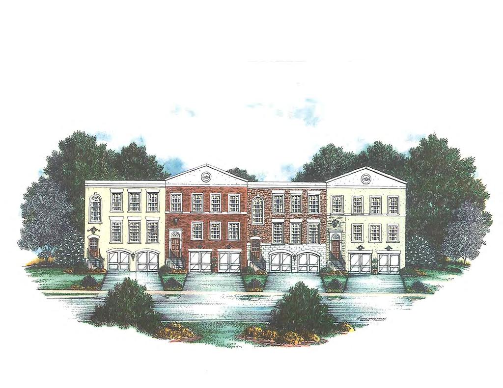
179

180
181 Residential Rezoning Impact on Local Schools Prepared for Gwinnett County, January 2014 Agenda Case # Schools Current Projections Proposed Zoning Approximate additional Student Forecast Capacity Over/Under Forecast Capacity Over/Under Forecast Capacity Over/Under Projections from Proposed Developments RZM South Gwinnett HS , , , Grace Snell MS , , , Rosebud ES , , , RZM Collins Hill HS , , , Creekland MS , , , Rock Springs ES 842 1, , , RZR Parkview HS , , , Trickum MS , , , Knight ES Current projections do not include new developments GCPS Planning Department /11/2013
182 C LEMS O N LANE HEATHER STONE WAY SPRINGTIME DRIVE SPRING BROO K DRIV E ROCK SPRINGS ROAD BE ACON COVE WYNHAVEN OAKS WAY ROCK SPRINGS PARK DOGWOOD HOLLOW BALL PARK SPRIGGS ROAD LANE ROCK SPRINGS ROAD SPRINGROCK WAY SPRINGROCK DRIVE SPRINGR OCK HILL TRAIL SPRINGTOR DRIVE ROCKFOUNT W AY SPRINGFOUNT TRAIL LANE BRAVES AVENUE WHITEBLUFF WAY PEACHSTONE WAY COLLINS VI EW COURT MAYFIELD COURT CLARION ROAD COLLINS GLEN COURT STILL FARMS COURT COLLINS HILL ROAD LOGAN WAY BRIARFIELD WAY WINDFALL TRACE LOCKEMEADE WAY LAKE ASHBOURNE ASHBOURNE DRIVE COLLINS HILL PARK FOR EST TRAIL TRAIL COLLINS COVE AVENUE WELLINGTON POINT DRIVE SILVERTHORNE POINT TROWBRIDGE L ANE PEACHTREE PARC LANE FOREST MEADOW LANE WOODBROOK WAY RZM Printed: November 5, 2013 TUSCANY PARK DRIVE WHITE RIDGE TRACE LINLEY TRACE MEADOWMEADE COVE LAUFIN COURT HIDDEN WOOD LANE MEADOW ISLE LANE Feet WH I TLOCK TRAIL SARANEL COURT WOODROW DRIVE ORACLE DRIVE SANDSTONE DRIVE OLD PEACHTREE ROAD COLLINS HILL GOLF COURSE PIERCE IVY COURT COURT COURAGEOUS YOUNG AMERICA DRIVE WALKER DRIVE TECH CENTER PARKWAY PRADA COU RT ONE WORLD DRIVE SLEW COURT C EDAR V A LLEY T R ACE MILLBANK COURT CLOCK FACE COURT SUWANEE POINTE DRIVE CEIBA COURT CEDAR FARMS DRIVE SLEW A VEN U E PINE POINT DRIVE OVERLOOK PARK LANE BELMONT RIDGE PINE STREAM COURT CLUB COURT CEDAR DRIVE PERRIN DRIVE FRIARS GATE DRIVE CHAUCER GATE COURT BR O OKFIE L D D RIVE PERRIN SPRINGS DRIVE AZALEA DRIVE BUFORD DRIVE
183
184 SANDSTONE DRIVE PIERCE BRENNE OLD PEACHTREE ROAD RZM Printed: November 5, Feet
185 SPRINGROCK HILL C SPRINGROCK WAY SPRINGTOR DRIVE R75 SPRINGROCK HILL TRAIL SPRINGFOUNT TRAIL PIERCE BRENNEN COURT M1 OVERLOOK PARK LANE ZT R100 OLD PEACHTREE ROAD BROOK FOREST DRIVE BEDROCK RUN SANDSTONE DRIVE PIERCE BRENNEN DRIVE PIERCE IVY COURT RZT TECH CENTER PARKWAY SUWANEE POINTE DRIVE MILLBANK COURT MILDON HALL LANE RM10 LAUFIN COURT CORDUN COURT WEST CORDU N COURT EAST WHITLOCK TRAIL R PRADA COURT R100 CLOCK FACE COURT AKE LANE EN WOOD LANE WOODCREST SARANEL COURT RZM Printed: November 5, 2013 WOODROW DRIVE MARTHAGEM COURT Feet COURAGEOUS COURT ONE WORLD DRIVE R100CSO ONE WORLD COURT YOUNG AMERICA DRIVE SLEW AVENUE R100 CEDAR DRIVE PINE STREAM DRIVE NE STREAM COURT
186 GWINNETT COUNTY DEPARTMENT OF PLANNING AND DEVELOPMENT REZONING ANALYSIS CASE NUMBER :RZR ZONING CHANGE :R-100 & O-I TO R-ZT LOCATION : BLOCKS OF FIVE FORKS TRICKUM ROAD :4200 BLOCK OF CEDAR BLUFF WAY MAP NUMBER :R ACREAGE :25.58 ACRES UNITS :57 UNITS PROPOSED DEVELOPMENT :SINGLE-FAMILY SUBDIVISION (REDUCTION IN BUFFERS) COMMISSION DISTRICT :(2) HOWARD FUTURE DEVELOPMENT MAP: EXISTING / EMERGING SUBURBAN APPLICANT: FD COMMUNITIES, LLC 2849 PACES FERRY ROAD ATLANTA, GA CONTACT: MARIAN ADEIMY PHONE: OWNER: ESTATE OF ANNIE LOU NASH 4255 FIVE FORKS-TRICKUM ROAD LILBURN, GA DEPARTMENT RECOMMENDATION: APPROVAL WITH CONDITIONS AS R-75 MODIFIED PROJECT DATA: The applicant requests rezoning of a acre tract from R-100 (Single Family Residence District) and O-I (Office-Institutional District) to R-ZT (Single Family Residence District). The subject property is located on the northwest side of Five Forks-Trickum Road, just southwest of Killian Hill Road. Until recently, the site was heavily wooded with one existing residence. Earlier in 2013 a substantial thinning of the trees occurred, pursuant to Land Disturbance Permit LDP The site also contains floodplain associated with Garner Creek. The submitted site plan shows 57 lots on acres, resulting in a gross density of 2.23 units per acre. Due to the presence of 8.58 acres of floodplain, the net density for the proposed development is 2.68 units per acre. The site plan indicates that the lots would be greater than the minimum lot size of 4,000 square feet for R-ZT zoning, with a typical lot being 5,750 square feet in area. The proposed lot width is 50 feet, and the minimum front yard setback of 20 feet, and side and rear yard setbacks of 5 feet and 25 feet respectively meet minimum R-ZT requirements.
187 RZR (AM) The applicant has proposed a minimum dwelling size of 2,400 square feet, and the submitted architectural elevations show two-story dwellings with a combination of siding, brick, stone and shake on front elevations. No indication was provided for the exterior treatments of the side and rear elevations. Each home would include a double-car garage. The development would be accessed by a single entrance/exit onto Five Forks-Trickum Road, which would align with Hasty Court. One storm water detention area is shown in the center portion of the property. The minimum required buffer for the requested zoning is 30 feet. The site plan depicts a reduced buffer of 25 feet along the north property line adjacent to Cedar Creek Crossing subdivision. ZONING HISTORY: The subject property has been zoned R-100 since GROUNDWATER RECHARGE AREA: The subject property is located within an identified Significant Groundwater Recharge Area. The Development would be served by sanitary sewer, resulting in minimal impact. WETLANDS INVENTORY: The subject property does not contain areas, streams, and/or bodies of water depicted as wetlands on the U.S. Department of Interior, Fish, and Wildlife Service National Wetlands Inventory map on file with the Gwinnett Department of Planning and Development. OPEN SPACE AND GREENWAY MATER PLAN: No comment. DEVELOPMENT REVIEW SECTION COMMENTS: The Buffer, Landscape and Tree Ordinance requires a ten-foot wide no-access easement along classified roadways for residential developments. The Buffer, Landscape and Tree Ordinance requires submittal and approval of a Tree Preservation and Replacement Plan prepared by a professional landscape architect prior to securing a Land Disturbance or Development permit. All open space areas/common areas shall meet the minimum road frontage and lot width requirements for a lot within the subdivision. Section b of the Development Regulations requires existing dead end/stub streets abutting a proposed project to be extended into the project by the developer, unless it is determined that there is an unacceptable land use conflict due to either dissimilar zoning or a serious topographical hardship. This will apply to Cedar Bluff Way. 2
188 RZR (AM) Section and/or of the Development Regulations requires a 200-foot deceleration lane with a 50-foot taper at each project entrance that proposes access to a Minor Collection Street or Major Thoroughfare. Right-of-way dedication to accommodate the deceleration lane and an 11- foot shoulder is also required. Reduction in length of a deceleration lane requires approval of a Modification by the Development Division; elimination of a deceleration lane requires approval of a Waiver by the Board of Commissioners. Section 6.13 of the Development Regulations requires construction of five-foot wide sidewalks along all exterior roadways adjoining the project, and four-foot wide sidewalks adjacent to both sides of all interior public streets (excluding cul-de-sac turnarounds). Section of the 1985 Zoning Resolution requires an additional five-foot setback for all structures (parking lots, driveways, detention ponds, retaining walls, etc.) adjacent to required buffers. The developer must submit detailed site development plans, including a landscape and tree preservation/replacement plan, for review and approval of the Development Division prior to any construction. The developer must submit a preliminary plat (construction plans), including a grading plan, tree plan, and road/sewer profiles for review and approval of the Development Division prior to any construction. Section of the Development Regulations requires submittal of a Storm Water Management Report for the project prior to obtaining a Land Disturbance or Development Permit. Section b of the Floodplain Management Ordinance requires that the lowest floor, including the basement, of all residential buildings be constructed at an elevation of at least three feet above the 100-year floodplain. Note that all recreation areas, open space and/or common areas (including storm water detention facility lots) located within the development shall be controlled by a mandatory Property Owner s Association (to include reported bylaws) with responsibility for maintenance, insurance, and taxes for open space areas. STORMWATER REVIEW SECTION COMMENTS: No comment. GWINNETT COUNTY DEPARTMENT OF TRANSPORTATION COMMENTS: Five Forks Trickum Road is a Major Arterial and 50 feet of right-of-way is required from the centerline, with 60 feet required within 500 feet of a major intersection. Standard deceleration lane with appropriate taper and adequate right-of-way will be required. 3
189 RZR (AM) Prior to the issuance of a Development Permit, a sight distance certification shall be provided. The number and locations of driveways are subject to Gwinnett County D.O.T. approval. GWINNETT COUNTY ENVIRONMENTAL HEALTH COMMENTS: No comment. GWINNETT COUNTY DEPARTMENT OF WATER RESOURCES COMMENTS: The available utility records show that the subject development is currently in the vicinity of a 16-inch water main located on the eastern right-of-way of Five Forks Trickum Road. Due to the uncontrollable variables, the Department of Water Resources makes no guarantees as to the minimum pressures or volumes available at a specific point within its system. Demands imposed by the proposed development may require reinforcements or extensions of existing water mains. Any cost associated with such required reinforcements or extensions will be the responsibility of the development and will not be provided by this department. The available utility records show that the subject development is currently in the vicinity of an 8-inch sanitary sewer main located approximately 40 feet west of the property. The subject development is located within the Patterson service area. There are currently no connection restrictions within this service area. Treatment capacity within this area is presently available on a first come - first serve basis. Demands imposed by the proposed development may require reinforcements or extensions of existing sewer mains. Any cost associated with such required reinforcements or extensions will be the responsibility of the development and will not be provided by this department. Developer shall provide easements for future sewer connection to all locations designated by DWR during plan review. As-built information for this department is dependent upon outside entities to provide record drawings for the utilities. Therefore this department does not guarantee the accuracy of the information provided. Extensions of the water and/or sanitary sewer systems within the subject development must conform to this department s policies and Gwinnett County s ordinances. Proceeding design, construction, inspection, and final acceptance of the required utilities, service to these utilities would then become available under the applicable utility permit rate schedules. BUILDING CONSTRUCTION SECTION COMMENTS: No comment. 4
190 RZR (AM) GWINNETT COUNTY FIRE SERVICES COMMENTS: No comment. DEPARTMENT ANALYSIS: The subject property is located on the northwest side of Five Forks-Trickum Road, just southeast of its intersection with Killian Hill Road. The site currently contains a single-family home and associated accessory structures, which would be removed. The stand of trees on the property has recently been thinned. The site contains floodplain associated with Garner Creek and a tributary stream, which also form its southwestern boundary. The 2030 Unified Plan Future Development Map indicates the property is located within an Existing/Emerging Suburban Character Area. Policies for this Character Area encourage singlefamily residential uses, and promote a variety of housing options. However, the zoning pattern for nearby and adjacent residential developments in the area could suggest that an R-75 Modified subdivision is more suitable than the proposed R-ZT development. This could be further supported by a recent rezoning nearby on Killian Hill Road approved as R-75 Modified, pursuant to RZR and SUP Approval as R-75 Modified could be compatible with existing subdivisions, a recent rezoning decision by the Board and consistent with policies of the Unified Plan urging compatibility of land use in zoning decisions. With the exception of an established commercial node to the northeast at Killian Hill Road, which includes offices and commercial retail, the surrounding area is primarily zoned and developed with R-75 and R-100 subdivisions. Adjacent to the north is the Cedar Creek Crossing subdivision, zoned R-75 and R-75 Modified. Adjacent to Cedar Crossing is Parkview Forest, zoned R-75 Modified. To the south of the subject site is Lynnwood Forest and across Five Forks-Trickum Road is Hasty Acres, and both subdivisions are zoned R-100. Although a small northern portion of the subject site is zoned O-I, it may not be sufficient justification to rezone the site to R-ZT. The subject property extends a substantial distance from the intersection, and the immediately surrounding subdivisions are zoned R-75 and R-100. In the Department s opinion, a more appropriate zoning classification may be R-75 Modified. With appropriate conditions governing house sizes and architecture, and overall density, an R-75 Modified single-family development could be consistent with adjacent and nearby subdivisions. In conclusion, the requested R-ZT zoning may not be considered consistent with the Unified Plan and could adversely affect other established subdivision developments in the vicinity. Therefore, the Department of Planning and Development recommends APPROVAL WITH CONDITIONS AS R-75 MODIFIED as a more suitable alternative. 5
191 PLANNING AND DEVELOPMENT DEPARTMENT RECOMMENDED CONDITIONS Approval as R-75 Modified for a Single Family Subdivision, subject to the following enumerated conditions: 1. To restrict the use of the property as follows: A. Single-family residential and accessory uses and structures. B. Homes shall be constructed with front façade accents of brick or stacked stone. The balance of the home may be the same or of cedar shake, stucco or fiber-cement siding. The first two homes on either side of the street at the development entrance shall also include a brick or stone water table. C. The minimum heated floor area per dwelling shall be 2,400 square feet. D. All homes shall have at least a double-car garage. 2. To satisfy the following site development considerations: A. All grassed areas on dwelling lots shall be sodded. B. The Five Forks-Trickum Road frontage shall include a landscaped entrance feature. Landscape and signage plans shall be subject to review and approval of the Director of Planning and Development. C. A street connection to Cedar Bluff Way is prohibited.
192 RZR (AM ) PLANNING AND DEVELOPMENT DEPARTMENT RECOMMENDATIONS STANDARDS GOVERNING EXERCISE OF THE ZONING SUITABILITY OF USE In light of the zoning and low-density residential developments in the area, an R-ZT rezoning may not be suitable at this location. An R-75 Modified subdivision could be more appropriate with existing R-100 and R-75 zoning and subdivisions in the area. ADVERSE IMPACTS With the recommended conditions, potential adverse impacts on nearby residential properties could be minimized. REASONABLE ECONOMIC USE AS ZONED The property has a reasonable economic use as currently zoned. IMPACTS ON PUBLIC FACILITIES An increase in traffic, utilities usage, storm water runoff, and the number of school-aged children could be anticipated from this request. CONFORMITY WITH POLICIES The 2030 Unified Plan Future Development Map indicates the property is located within an Existing/Emerging Suburban Character Area and could support the approval of a single-family subdivision. However, the requested R-ZT zoning may be out of character with existing R-100 and R-75 developments in the area. An R-75 Modified subdivision could be more suitable and consistent with policies of the Unified Plan and surrounding subdivisions. CONDITIONS AFFECTING ZONING There are subdivisions along Five Forks-Trickum Road and Killian Hill Road, in close proximity to the subject property, that have been rezoned to R-75 and R-75 Modified giving support for an R-75 Modified approval. 7
193
194
195
196
197
198
199 Residential Rezoning Impact on Local Schools Prepared for Gwinnett County, January 2014 Agenda Case # Schools Current Projections Proposed Zoning Approximate additional Student Forecast Capacity Over/Under Forecast Capacity Over/Under Forecast Capacity Over/Under Projections from Proposed Developments RZM South Gwinnett HS , , , Grace Snell MS , , , Rosebud ES , , , RZM Collins Hill HS , , , Creekland MS , , , Rock Springs ES 842 1, , , RZR Parkview HS , , , Trickum MS , , , Knight ES Current projections do not include new developments GCPS Planning Department /11/2013
200 6-112 GATE WAY TOWN CRIER ROAD WARRIOR TRAIL SEQUOIA DRIVE FRANCIS PLACE HALE PLACE HALE DRIVE LYN G A TE DRIVE CATAMOUNT DRIVE CANCELLI COURT CATAMOUNT W AY KENION FOREST WAY RED CEDAR COVE CEDAR W O OD DRIVE TRILLIUM WINDSONG COURT DUNRIVER DRIVE LANE LEE PARK SITE MONTEGO WAY ROLLING FOREST LANE BRADFORD COUR DORSEY CIRCLE MANDALAY COURT T VA LLEY DRIV E CEDAR CREEK TRAIL SUGARBERRY LANE WESTON DRIVE BRU CE WAY CEDAR TRACE WESTON WAY CEDAR BLUFF WAY CEDAR BLUFF TRAIL MANDALAY D RIVE WHITE OAK CIRCLE HICKORY RIDGE ROAD HASTY COURT RIDG EVIEW DRIVE PINECREST CIRCLE WASH L EE COURT WHEATLEY DRIVE TOM SMITH ROAD DARLING COURT KILLIAN HILL ROAD GRAHAM WAY WATER OAK TERRACE PLYMOUTH DRIVE N ASH L E E DRIVE C OLO NIAL TRAIL KILLIAN WAY GWENS TRAIL MARY LEE LANE STAPLES DRIVE MEANDERING WAY JETTIE COURT LEE RIDGE WAY LARK VIEW DRIVE TER E SA TERRACE 6-84 COLE DRIVE 6-93 J. B. WILLIAMS PARK SITE CHARLIE LANE 6-92 CARLA JOE DRIVE MADISON COURT PARKVIEW WAY RZR Printed: November 5, 2013 ADMIRAL R ADAMS COURT BAY POINTE WAY IDGE WAY BEACON HILL DRIVE FIVE FORKS TRICKUM ROAD LAKE LUCERNE ROAD CHESAPEAKE DRIVE TRED AVON WAY RENEE DRIVE Feet PARKV I EW WALK DRIVE KEITH DRIVE TIMBERLAND DRIVE ABERDEEN ROAD OLEANDER DRIVE TIMBER GLEN COU R T D E ER BROOK WAY 6-83 RUNNYMEDE DRIVE FAWNB R OOK COURT YELLO W PINE DRIV E PINERIDGE DRIVE

201
202 LL COURT CEDAR FALLS COURT DUNRIVER DRIVE MANDALAY COURT WESTON WAY CEDAR CREEK DRIVE TALIFERRO CO KILLIAN HILL ROAD HICKORY RIDGE R BRADFORD COURT KILLIAN HILL ROAD WESTON DRIVE WASH LEE COURT CEDAR CREST COURT CEDAR BLUFF WAY CEDAR BLUFF TRAIL FIVE FORKS TRICKUM ROAD WASH LEE DRIVE HASTY COURT GRAHAM W WHEATLEY DRIVE FOREST VIEW COURT RZR FOREST VIEW LANE TIMBER PATH COURT MANDALAY DRIVE OLEANDER DRIVE NICHOLS COURT MANDALAY COURT Printed: November 5, Feet TIMBERLAND DRIVE TIMBER GLEN COURT
203 6-102 BRADFORD COUR T CEDAR CREEK DRIVE R100 SUGARBER WESTON WAY TALIFERRO COUR R100 OI C2 R100 C2 HICKORY RIDGE RO NS C1 OI C3 O DUNRIVER DRIVE CEDAR CREST COURT WESTON DRIVE CEDAR BLUFF WAY R75 CEDAR BLUFF TRAIL OI 6-90 C2 KILLIAN HILL ROAD OI DARLING COURT CEDAR FALLS COURT WASH LEE DRIVE HASTY COURT R75MOD WHEATLEY DRIVE R100 WASH LEE COURT GRAHAM WAY TIMBER HILL COURT OLLING FOREST LANE 6-91 DEERBROOK W R100 LING FOREST COURT FOREST VIEW COURT TIMBER PATH COURT RZR FOREST VIEW LANE Printed: November 5, 2013 UCERNE ROAD MANDALAY COURT Feet MANDALAY DRIVE TIMBERLAND DRIVE FIVE FORKS TRICKUM ROAD OLEANDER DRIVE 6-82 NICHOLS COURT 6-83 TIMBER GLEN COURT DEERBROOK WAY
204 GWINNETT COUNTY DEPARTMENT OF PLANNING AND DEVELOPMENT SPECIAL USE PERMIT ANALYSIS CASE NUMBER :SUP ZONING :M-1 LOCATION :1400 BLOCK OF WINDER HIGHWAY MAP NUMBER :R ACREAGE :8.91 ACRES PROPOSED DEVELOPMENT :BULK STORAGE TANKS (42 FEET IN HEIGHT) COMMISSION DISTRICT :(4) HEARD FUTURE DEVELOPMENT MAP: RESEARCH AND DEVELOPMENT CORRIDOR APPLICANT: WB SERVICES, LLC C/O MILL CREEK CONSULTING 4480 COMMERCE DRIVE, SUITE A BUFORD, GA CONTACT: MITCH PEEVY PHONE: OWNER: CSX TRANSPORTATION, INC. 500 WATER STREET JACKSONVILLE, FL DEPARTMENT RECOMMENDATION: APPROVAL WITH CONDITIONS PROJECT DATA: The applicant requests a Special Use Permit on an 8.91acre portion of a larger tract, zoned M-1 (Light Industry District), for above ground bulk storage tanks for the storage and distribution of ethanol fuel. The tanks would be located within the rail yard compound of Total Distribution Services Inc. (TDSI), which is an automobile distribution facility located on the northwest side of Winder Highway, just southwest of Alcovy Industrial Boulevard. The subject property is part of the Gwinnett Progress Center. The property is currently occupied by TDSI, an automobile distribution facility occupying approximately 124 acres. The proposed bulk storage tank would be roughly centered within the TDSI compound, in a leased area consisting of 8.91 acres. The proposed facility would be comprised of three storage tanks, asphalt paving and a rail yard. Each of the three tanks would have an approximate height of 42 feet, and a storage capacity of approximately 1.5 million gallons. According to the letter of intent, the tanks would be recessed 6 feet into the ground, with the remaining 36 feet rising above ground level. Fuel would be transported to the site via rail, and stored in the tanks for subsequent distribution by tanker truck.
205 SUP (TH) Access to the site is via two existing driveways which extend from Winder Highway, and an industrial spur (secondary track) which extends from the Seaboard Coastline Railroad right-ofway, which traverses along the rear property line of the TDSI facility. ZONING HISTORY: In 1970, the property was zoned RA-200 (Agriculture-Residence District). In 1973, the part of the property was rezoned to M-1, pursuant to RZ The overall property was rezoned to M-1 in 1985, pursuant to RZ , as part of the Gwinnett Progress Center. GROUNDWATER RECHARGE AREA: The subject property is not located within an identified Significant Groundwater Recharge Area. WETLANDS INVENTORY: The subject property does not contain areas, streams and/or bodies of water depicted as wetlands on the U.S. Department of Interior, Fish and Wildlife Service National Wetlands Inventory map on file with the Gwinnett Department of Planning and Development. DEVELOPMENT REVIEW SECTION COMMENTS: The developer must obtain a Land Disturbance or Development Permit from the Development Division prior to any construction. Section of the Development Regulations requires submittal of a Storm Water Management Report for the project prior to obtaining a Land Disturbance or Development Permit. STORMWATER REVIEW SECTION COMMENTS: No comment. GWINNETT COUNTY DEPARTMENT OF TRANSPORTATION COMMENTS: Winder Highway is a State Route and Georgia D.O.T. right-of-way requirements govern. Coordinate with the Georgia D.O.T. regarding access. The applicant must file an FAA Form with the FAA and comply with all conditions imposed by the FAA. GWINNETT COUNTY ENVIRONMENTAL HEALTH COMMENTS: No comment. 2
206 SUP (TH) GWINNETT COUNTY DEPARTMENT OF WATER RESOURCES COMMENTS: The available utility records show that the subject development is currently in the vicinity of a 10-inch water main located on the southern right-of-way of Winder Highway. The available utility records show that the subject development is currently in the vicinity of a 30-inch sanitary sewer main, a 16-inch sanitary sewer main and an 8-inch sanitary sewer main located on the property. BUILDING CONSTRUCTION SECTION COMMENTS: Building Plan Review has no objections under the following conditions: 1. The applicant shall submit civil site drawings to Building Plan Review for review and approval. 2. The applicant shall submit structural, electrical and plumbing drawings for each bulk tank structure for review and approval by Building Plan Review. 3. Each tank structure shall comply with the height and area limitations of Table 503 and the fire resistive and horizontal separation requirements of Table 601 and 602 of the 2006 International Building Code with Georgia state amendments based on occupancy group classification, type of construction, and location of each building from property lines and other buildings. 4. Upon completion of plan review approvals, the applicant shall obtain a building permit for each tank structure and achieve satisfactory field inspections for issuance of a Certificate of Occupancy. For assistance, you may contact this office at (678) Monday through Friday from the hours of 8:00 a.m. to 5:00 p.m. GWINNETT COUNTY FIRE SERVICES COMMENTS: Fire Plan Review has no objections to the above rezoning requests, under the following conditions: 1. Applicant submits civil drawings to Fire Plan Review for review and approval. 2. Applicant submits architectural drawings to Fire Plan Review for review and approval. 3. Upon completion of plan review approvals, applicant successfully achieves a satisfactory Fire field inspection, for issuance of a Certificate of Occupancy - Business Operation. For assistance, you may contact this office at (678) , Monday through Friday, from the hours of 8:00 a.m. to 5:00 p.m. 3
207 SUP (TH) DEPARTMENT ANALYSIS: The subject site is an 8.91-acre leased area, zoned M-1, located within the confines of the TDSI facility on Winder Highway, and located just southwest of Alcovy Industrial Boulevard. The TDSI site is a large automobile storage and distribution facility. The requested Special Use Permit proposes the expansion of the day to day operations of the facility to include the addition of 3 bulk storage tanks for the storage and distribution of ethanol fuel. The 2030 Unified Plan Future Development Map indicates that the site is located within the Research and Development Corridor. Although not strictly consistent with the Character Area, the proposed addition of above ground bulk storage tanks could be compatible with existing uses and zoning in the immediate area. Industrial activities in the immediate area include trucking facilities, warehouse and distribution, light manufacturing businesses, and Briscoe Field with its associated aviation fuel storage. The area located along the north side of Winder Highway is developed with a mix of industrial and commercial uses and zoning. The subject property and surrounding properties are part of the Gwinnett Progress Center, which is a planned industrial park created to serve as a major portion of the County s industrial base. The Progress Center is developed with various industrial uses with intense operations; including, the use of heavy equipment operating in outdoor storage areas, heavy truck traffic and rail service to and from several of the sites. The area to the south, across Winder Highway, consists of scattered single-family homes on large acreage tracts zoned RA-200, MH and an undeveloped R-ZT zoned property approved for a single-family development. Immediately adjacent to the TDSI site is Allied Systems, a truck repair facility which is provided inter-parcel access from the TDSI site. To the east is Alcovy Industrial Boulevard which includes office/warehouse buildings and associated outdoor storage areas with potential rail access. The proposed fuel storage tanks could be considered consistent with the overall development pattern established for the area, and with other uses of the Gwinnett Progress Center. Additionally, the proposed location of the tanks interior to the TDSI site should help reduce their visibility from neighboring properties and rights-of-way. In conclusion, the proposed bulk storage tanks could be compatible with the intensity of surrounding industrial uses and development in the area. Therefore, the Department of Planning and Development recommends APPROVAL WITH CONDITIONS of this request. 4
208 SUP (TH) PLANNING AND DEVELOPMENT DEPARTMENT RECOMMENDED CONDITIONS Approval of a Special Use Permit for three bulk storage tanks, subject to the following enumerated conditions: 1. The storage tanks shall be limited to no more than 45 feet in overall height, with no more than 40 feet extending above the surrounding ground level. 2. As required by the Director of Planning and Development, provide additional vegetative screening on the TDSI site along Highway 316 and Winder Highway to obscure the visibility of the tanks from these roadways. 3. Final structural elevations, including the colors and graphics applied to the tanks, shall be subject to review and approval of the Director of Planning and Development. 5
209 SUP (TH) PLANNING AND DEVELOPMENT DEPARTMENT RECOMMENDATIONS STANDARDS GOVERNING EXERCISE OF ZONING SUITABILITY OF USE In light of the industrial nature of the area and the proposed location of the tanks interior to the large distribution facility, the requested Special Use Permit could be suitable at this location. ADVERSE IMPACTS Given the existing trucking, storage and distribution activities provided at the site, the addition of the proposed bulk storage tanks should not adversely impacts nearby properties. REASONABLE ECONOMIC USE AS ZONED The property has a reasonable economic use as currently zoned. IMPACT ON PUBLIC FACILITIES No significant impacts on public facilities are anticipated from the addition of three bulk storage tanks. CONFORMITY WITH POLICIES Although not strictly consistent with the projected future land use in the Unified Plan, the request could be compatible with surrounding uses, including the Gwinnett Progress Center and Briscoe Field. CONDITIONS AFFECTING ZONING The site s close proximity to Georgia Highway 316, rail service and its location within the Gwinnett Progress Center give supporting grounds for approval. 6
210
211
212 PROGRESS CENTER AVENUE HURRICANE TRAIL HURRICANE SHOALS ROAD FENCE ROAD SR316W HIGHWAY SR316E HIGHWAY DACULA ALCOVY INDUSTRIAL BOULEVARD CEDARS ROAD WINDER HIGHWAY BRISCOE BOULEVARD GRENIER TERRACE SUP Printed: November 5, 2013 BOULDERBROOK CIRCLE Feet OLD ATHENS ROAD HERCULES TRAIL ROCK HOU SE ROAD KEY MANOR LANE HARDY WATER DRIVE ASTER IVES DRIVE TULIP LANE ALCOVY RIVER GREENSPACE (DIXON TRACT) FERN WALK LILY VALLEY DRIVE
213
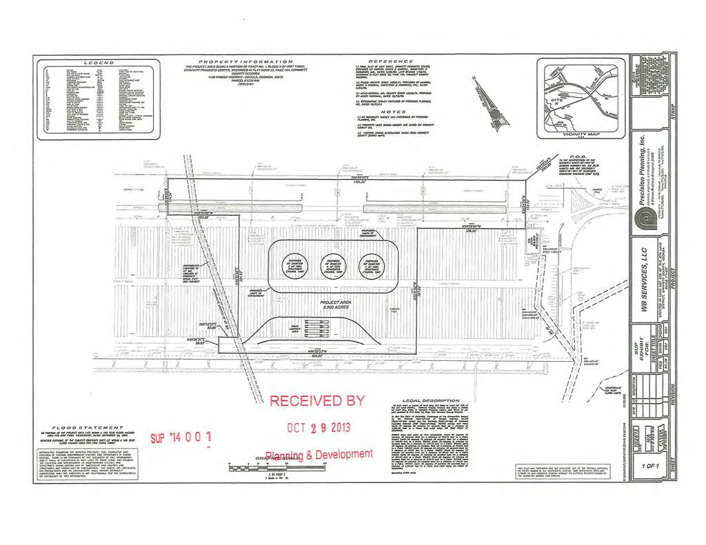
214
MUNICIPAL-GWINNETT COUNTY PLANNING COMMISSION PUBLIC HEARING AGENDA GWINNETT JUSTICE AND ADMINISTRATION CENTER TUESDAY, JANUARY 3, 2017 AT 7:00 P.M.
 MUNICIPAL-GWINNETT COUNTY PLANNING COMMISSION PUBLIC HEARING AGENDA GWINNETT JUSTICE AND ADMINISTRATION CENTER TUESDAY, JANUARY 3, 2017 AT 7:00 P.M. AS SET FORTH IN THE AMERICANS WITH DISABILITIES ACT
REPORT TO THE SHELBY COUNTY PLANNING COMMISSION From the Department of Development Services Planning Services. February 4, 2019
 REPORT TO THE SHELBY COUNTY PLANNING COMMISSION From the Department of Development Services Planning Services February 4, 2019 Case No. Request for Rezoning Approval From E-1 to E-2 SD This is a request
Community Development
 Land Use Petition RZ-15-010 Concurrent Variance VC-15-010-01 Date of Staff Recommendation Preparation: August 14, 2015 Date of Planning Commission Recommendation: September 1, 2015 PROJECT LOCATION: DISTRICT/SECTION/LANDLOT(S):
MUNICIPAL-GWINNETT COUNTY PLANNING COMMISSION PUBLIC HEARING AGENDA GWINNETT JUSTICE AND ADMINISTRATION CENTER TUESDAY, MAY 2, 2017 AT 7:00 P.M.
 MUNICIPAL-GWINNETT COUNTY PLANNING COMMISSION PUBLIC HEARING AGENDA GWINNETT JUSTICE AND ADMINISTRATION CENTER TUESDAY, MAY 2, 2017 AT 7:00 P.M. AS SET FORTH IN THE AMERICANS WITH DISABILITIES ACT OF 1992,
O-I (Office-Institutional) and AG-1(Agricultural)
 and AG-1(Agricultural)") PROPERTY INFORMATION ADDRESS 3503 and 3505 Bethany Bend DISTRICT, LAND LOTS 2/1 973 and 974 OVERLAY DISTRICT State Route 9 PETITION NUMBERS EXISTING ZONING O-I (Office-Institutional) and AG-1(Agricultural)
PROPERTY INFORMATION ADDRESS 3503 and 3505 Bethany Bend DISTRICT, LAND LOTS 2/1 973 and 974 OVERLAY DISTRICT State Route 9 PETITION NUMBERS EXISTING ZONING O-I (Office-Institutional) and AG-1(Agricultural)
1.94 acres. Gwinnett Prado, L.P. c/o Brogdon Consulting Duluth, GA Contact: Ted Sandler
 Land Use Petition RZ-15-006 Date of Staff Recommendation Preparation: April 21, 2015 Revised to Incorporate Planning Commission Recommendations: 5/6/15 PROJECT LOCATION: 10800 Block of State Bridge Road
COMMERCIAL SITE DEVELOPMENT GUIDE FOR UNINCORPORATED ST. CHARLES COUNTY
 COMMERCIAL SITE DEVELOPMENT GUIDE FOR UNINCORPORATED ST. CHARLES COUNTY GENERAL INFORMATION: This brochure is to be used as a guide and is not intended to amend or supersede the corresponding County ordinances
Recommend approval of the Variances identified and Rezone to Residential Multi-Family (RM) District with following conditions:
 District with following conditions:") City of Sugar Hill Planning Staff Report RZ 17-001 DATE: June 20, 2017: Updated 7/10/17 TO: Mayor and City Council FROM: Tim Schick, Administrative Staff SUBJECT: Rezoning RZ 17-001 Rezoning with Variances
City of Sugar Hill Planning Staff Report RZ 17-001 DATE: June 20, 2017: Updated 7/10/17 TO: Mayor and City Council FROM: Tim Schick, Administrative Staff SUBJECT: Rezoning RZ 17-001 Rezoning with Variances
LINCOLN COUNTY PLANNING & INSPECTIONS DEPARTMENT
 LINCOLN COUNTY PLANNING & INSPECTIONS DEPARTMENT 302 NORTH ACADEMY STREET, SUITE A, LINCOLNTON, NORTH CAROLINA 28092 704-736-8440 OFFICE 704-736-8434 INSPECTION REQUEST LINE 704-732-9010 FAX To: Board
Community Development
 Land Use Petition RZ-16-002 Date of Staff Recommendation Preparation: April 15, 2016 (CEL) Date of Planning Commission Recommendation: May 3, 2016 PROJECT LOCATION: DISTRICT/SECTION/LANDLOT(S): ACREAGE
Gwinnett County Zoning Board of Appeals
 Gwinnett County Zoning Board of Appeals Tuesday, June 12, 2012 6:30 PM Public Hearing Agenda I. Call to Order, Pledge to Flag II. III. Opening Remarks by Chairman Approval of Agenda IV. Approval of Minutes
Gwinnett County Board of Commissioners
 Tuesday, November 22, 2005-7:00 PM I. Call To Order, Invocation, Pledge to Flag II. Opening Remarks by Chairman III. Approval of Agenda IV. Approval of Minutes: November 16, 2005 November 22, 2005 Executive
Planning Department Oconee County, Georgia
 Planning Department Oconee County, Georgia STAFF REPORT REZONE CASE #: 6985 DATE: October 31, 2016 STAFF REPORT BY: Andrew C. Stern, Planner APPLICANT NAME: Williams & Associates, Land Planners PC PROPERTY
MUNICIPAL-GWINNETT COUNTY PLANNING COMMISSION PUBLIC HEARING AGENDA GWINNETT JUSTICE AND ADMINISTRATION CENTER TUESDAY, FEBRUARY 7, 2017 AT 7:00 P.M.
 MUNICIPAL-GWINNETT COUNTY PLANNING COMMISSION PUBLIC HEARING AGENDA GWINNETT JUSTICE AND ADMINISTRATION CENTER TUESDAY, FEBRUARY 7, 2017 AT 7:00 P.M. AS SET FORTH IN THE AMERICANS WITH DISABILITIES ACT
GWINNETT COUNTY CSO CONSERVATION SUBDIVISION OVERLAY DISTRICT REQUIREMENTS
 GWINNETT COUNTY CSO CONSERVATION SUBDIVISION OVERLAY DISTRICT REQUIREMENTS Section 1316. CSO Conservation Subdivision Overlay District. 1. Purposes. The purposes of this overlay district are as follows:
9. REZONING NO Vicinity of the northwest corner of 143 rd Street and Metcalf Avenue
 9. REZONING NO. 2002-15 Vicinity of the northwest corner of 143 rd Street and Metcalf Avenue 1. APPLICANT: Andrew Schlagel is the applicant for this request. 2. REQUESTED ACTION: The applicant is requesting
EXHIBIT D. Planned Unit Development Written Description April 13, 2016 Rouen Cove Phase II PUD
 1 EXHIBIT D Planned Unit Development Written Description April 13, 2016 Rouen Cove Phase II PUD Development # 8986.001 Developer: Curtis L. Hart Hart Resources LLC 8051 Tara Lane Jacksonville, Florida
Staff Report: Date: Applicant: Property Identification: Acreage of Request: Current Zoning of Requested Area: Requested Action: Attached:
 Staff Report: Completed by Jeff Palmer Director of Planning & Zoning Date: November 7, 2018 Applicant: Greg Smith, Oberer Land Developer agent for Ronald Montgomery ET AL Property Identification: Frontage
4 June 11, 2014 Public Hearing
 4 June 11, 2014 Public Hearing APPLICANT: FRANKLIN JOHNSTON MANAGEMENT DEVELOPMENT, L.L.C. PROPERTY OWNER: TRUSTEES OF FIRST LYNNHAVEN BAPTIST CHURCH STAFF PLANNER: Stephen J. White REQUEST: Change of
Staff Report & Recommendation Rezoning Case RZ Date of Report: June 6, 2014 Report by: Doug Stacks
 Staff Report & Recommendation Rezoning Case RZ-2014-02 Date of Report: June 6, 2014 Report by: Doug Stacks Hearing Dates: Planning Commission June 26, 2014 Mayor and Council July 14, 2014 GENERAL INFORMATION
5/24/2018 RZ Page 1 of 3
 City of Sugar Hill Planning Staff Report RZ 18-004 DATE: May 24, 2018; Updated 6/5/2018 TO: Mayor and City Council FROM: Planning Director SUBJECT: Rezoning RZ 18-004 Ansley Hillcrest LLC, Hillcrest Drive
PLANNED UNIT DEVELOPMENT STAFF REPORT Date: October 19, 2017
 PLANNED UNIT DEVELOPMENT STAFF REPORT Date: October 19, 2017 DEVELOPMENT NAME LOCATION Custom Boat Storage 3975 Demetropolis Road (East side of Demetropolis Road, 0.2± miles South of Halls Mill Road.)
Rezoning Petition Zoning Committee Recommendation June 29, 2017
 Rezoning Petition 2017-076 Zoning Committee Recommendation June 29, 2017 REQUEST Current Zoning: MUDD-O (mixed use development, optional) and R-4 (single family residential) Proposed Zoning: UR-2(CD) (urban
PLANNED UNIT DEVELOPMENT & SUBDIVISION STAFF REPORT Date: April 18, 2019
 PLANNED UNIT DEVELOPMENT & SUBDIVISION STAFF REPORT Date: April 18, 2019 DEVELOPMENT NAME SUBDIVISION NAME Springhill Village Subdivision Springhill Village Subdivision LOCATION 4350, 4354, 4356, 4358,
Staff Planner Carolyn A.K. Smith
 Applicant Property Owner, Pamela K. & Steven A. Gray Public Hearing April 13, 2016 City Council Election District Princess Anne Agenda Item 8 Request Modification of Proffers (Modification to the proffer
THE CITY OF RAYMORE, MISSOURI Single-Family Residential Zoning Districts
 THE CITY OF RAYMORE, MISSOURI Single-Family Residential Zoning Districts REGULATIONS COMMON TO ALL DISTRICTS: Uses permitted in each district include detached single-family dwellings, manufactured homes
DAUPHIN CREEK ESTATES SUBDIVISION
 # 12 SUB-000076-2017 DAUPHIN CREEK ESTATES SUBDIVISION Engineering Comments: FINAL PLAT COMMENTS (should be addressed prior to submitting the FINAL PLAT for review and/or signature by the City Engineer):
HERON LANDING SUBDIVISION
 HERON LANDING SUBDIVISION Engineering Comments: Per FEMA guidelines, any development greater than 5 acres in size or subdivision 50 lots in size, requires a flood study. Width of drainage easement to be
ARTICLE 5 GENERAL REQUIREMENTS
 5.1 SUITABILITY OF THE LAND ARTICLE 5 GENERAL REQUIREMENTS 5.1.1 Land subject to flooding, improper drainage or erosion, and land deemed to be unsuitable for development due to steep slope, unsuitable
PLANNING COMMISSION REPORT Regular Agenda - Public Hearing Item
 Z-15-00469 Item No. 6A- 1 PLANNING COMMISSION REPORT Regular Agenda - Public Hearing Item PC Staff Report 11/16/15 ITEM NO. 6A GPI, RM12, & RS40 TO RM12; 14.756 ACRES; 5200 & 5300 CLINTON PKWY (SLD) Z-15-00469:
PLANNING COMMISSION REPORT Regular Agenda Public Hearing Item
 PC Staff Report 11/12/12 Item No. 2B- 1 PLANNING COMMISSION REPORT Regular Agenda Public Hearing Item ITEM NO. 2B: A TO GPI; 110 ACRES; E OF K-10 & N OF W 6 TH ST (MKM) : Consider a request to rezone approximately
PLANNING BOARD AGENDA
 PLANNING BOARD AGENDA Public Hearing and Administrative Meeting Wednesday,, 1:30 P.M. Omaha/Douglas Civic Center 1819 Farnam Street Legislative Chamber DISPOSITION AGENDA This document states the disposition
Cover Letter with Narrative Statement
 Cover Letter with Narrative Statement March 31, 2017 rev July 27, 2017 RE: Rushton Pointe Residential Planned Unit Development Application for Public Hearing for RPUD Rezone PL2015 000 0306 Mr. Eric Johnson,
RE: 6. GILL/GREEN COMPREHENSIVE PLAN AMENDMENT, REZONING AND PRELIMINARY PLAT
 commission memo DATE: Thursday - August 9, 2018 TO: Marion Planning & Zoning Commission FROM: David N. Hockett, AICP Principal Planner RE: 6. GILL/GREEN COMPREHENSIVE PLAN AMENDMENT, REZONING AND PRELIMINARY
Staff Report: Date: Applicant: Property Identification: Acreage of Request: Current Zoning of Requested Area: Requested Action: Attached:
 Staff Report: Completed by Jeff Palmer Director of Planning & Zoning Date: November 7, 2018, Updated November 20, 2018 Applicant: Greg Smith, Oberer Land Developer agent for Ronald Montgomery ET AL Property
ZONING AMENDMENT & SUBDIVISION STAFF REPORT Date: March 1, 2018
 #13 SUB-000406-2018 & ZON-000407-2018 ZONING AMENDMENT & SUBDIVISION STAFF REPORT Date: March 1, 2018 NAME SUBDIVISION NAME LOCATION Creekside @ Kooiman Dairy Creekside @ Kooiman Dairy Subdivision (South
Draft Model Access Management Overlay Ordinance
 Draft Model Access Management Overlay Ordinance This model was developed using the City of Hutchinson and the Trunk Highway 7 corridor. The basic provisions of this model may be adopted by any jurisdiction
Cobb County Community Development Agency Zoning Division 1150 Powder Springs St. Marietta, Georgia 30064
 Cobb County Community Development Agency Zoning Division 1150 Powder Springs St. Marietta, Georgia 30064 Case # Z-63 Public Hearing Dates: PC: 11-06-18 BOC: 11-20-18 SITE BACKGROUND Applicant: Loyd Development
Courtyards at Kinnamon Park Sketch Plan
 Courtyards at Kinnamon Park Sketch Plan Courtyards at Kinnamon Park Sketch Plan Staff Analysis PART 1: PROJECT SUMMARY Applicant: EPCON Communities Property Owner: Johnsie M. Kinnamon Heirs, Douglas and
DEVELOPMENT DEPARTMENT STAFF REPORT THE PARK AT 5 TH
 DEVELOPMENT DEPARTMENT STAFF REPORT ARB Meeting Date: July 3, 2018 Item #: _PZ2018-293_ THE PARK AT 5 TH Request: Site Address: Project Name: Parcel Number: Applicant: Proposed Development: Current Zoning:
PLANNED DEVELOPMENT DISTRICT STANDARDS. Cadence Site
 PLANNED DEVELOPMENT DISTRICT STANDARDS Cadence Site A Planned Development District 1. Statement of General Facts, Conditions and Objectives Property Size: Approximately 57.51 Acres York County Tax Map
BOARD OF COMMISSIONERS GWINNETT COUNTY LAWRENCEVILLE, GEORGIA RESOLUTION
 BOARD OF COMMISSIONERS GWINNETT COUNTY LAWRENCEVILLE, GEORGIA RESOLUTION READING AND ADOPTION: At the regular meeting of the Gwinnett County Board of Commissioners, held in the Justice and Administration
SUBDIVISION, PLANNED UNIT DEVELOPMENT, ZONING AMENDMENT, & SIDEWALK WAIVER STAFF REPORT Date: July 19, 2018
 SUBDIVISION, PLANNED UNIT DEVELOPMENT, ZONING AMENDMENT, & SIDEWALK WAIVER STAFF REPORT Date: July 19, 2018 NAME SUBDIVISION NAME LOCATION West Mobile Properties, LLC U.S. Machine Subdivision 556, 566,
TOWN OF ORO VALLEY PLANNING & ZONING COMMISSION MEETING DATE: December 6, 2011
 PLANNING & ZONING COMMISSION MEETING DATE: December 6, 2011 TO: FROM: SUBJECT: PLANNING & ZONING COMMISSION Matt Michels, Senior Planner mmichels@orovalleyaz.gov; tel. 229-4822 Public Hearing: Rancho de
ARTICLE 23 CONDOMINIUM STANDARDS
 ARTICLE 23 CONDOMINIUM STANDARDS Section 23.01 Intent. The intent of this Article is to provide regulatory standards for condominiums and site condominiums similar to those required for projects developed
Development Plan DP13-3 (Arlington Lofts) Planning and Zoning Meeting Date: Document Being Considered: Ordinance
 Planning and Zoning Meeting Date: Document Being Considered: Ordinance") Staff Report Development Plan DP13-3 (Arlington Lofts) Planning and Zoning Meeting Date: 6-19-13 Document Being Considered: Ordinance RECOMMENDATION Following the public hearing, consider Development Plan
Staff Report Development Plan DP13-3 (Arlington Lofts) Planning and Zoning Meeting Date: 6-19-13 Document Being Considered: Ordinance RECOMMENDATION Following the public hearing, consider Development Plan
MUNICIPAL-GWINNETT COUNTY PLANNING COMMISSION PUBLIC HEARING AGENDA
 MUNICIPAL-GWINNETT COUNTY PLANNING COMMISSION PUBLIC HEARING AGENDA GWINNETT JUSTICE AND ADMINISTRATION CENTER WEDNESDAY, DECEMBER 7, 2016 AT 7:00 P.M. AS SET FORTH IN THE AMERICANS WITH DISABILITIES ACT
Conditional Use Permit case no. CU 14-06: Bristol Village Partners, LLC
 PLANNING AND ZONING COMMISSION STAFF REPORT August 7, 2014 Conditional Use Permit case no. CU 14-06: Bristol Village Partners, LLC CASE DESCRIPTION: LOCATION: LEGAL DESCRIPTION: EXISTING LAND USE: ZONING:
Rezoning Petition Pre-Hearing Staff Analysis April 15, 2019
 Rezoning Petition 2018-132 Pre-Hearing Staff Analysis April 15, 2019 REQUEST Current Zoning: R-3 (single family residential) Proposed Zoning: MUDD-O (mixed use development, optional) with five-year vested
City of Peachtree City. Annexation Review Process
 City of Peachtree City Annexation Review Process Page 1 Annexation Review Process Step One: Initial annexation information The following information is to be completed by the property owner and/ or their
INDIAN RIVER COUNTY, FLORIDA. The Honorable Members of the Planning and Zoning Commission DEPARTMENT HEAD CONCURRENCE
 Public Hearing Legislative INDIAN RIVER COUNTY, FLORIDA M E M O R A N D U M TO: The Honorable Members of the Planning and Zoning Commission DEPARTMENT HEAD CONCURRENCE Robert M. Keating, AICP; Community
Town of Windham Land Use Ordinance Sec. 400 Zoning Districts SECTION 400 ZONING DISTRICTS
 Town of Windham Land Use Ordinance Sec. 400 Zoning Districts Sections SECTION 400 ZONING DISTRICTS SECTION 400 ZONING DISTRICTS 4-1 401 Districts Enumerated 4-2 402 Location of districts; Zoning Map 4-2
SECTION 4: PRELIMINARY PLAT
 SECTION 4: PRELIMINARY PLAT After the completion of the sketch plan process, if submitted, the owner or developer shall file with the City an application for preliminary plat. The preliminary plat stage
UDO Advisory Committee Meeting #3 August 18, 2011
 UDO Advisory Committee Meeting #3 August 18, 2011 Today s s Agenda Welcome Recap of Meeting #2 Overview of Strategy Statement Overview of Zoning Districts What changes and what stays the same? Break Putting
ZONING AMENDMENT & SUBDIVISION STAFF REPORT Date: November 3, 2016
 ZONING AMENDMENT & SUBDIVISION STAFF REPORT Date: November 3, 2016 APPLICANT NAME SUBDIVISION NAME David Shumer 5955 Airport Subdivision CITY COUNCIL DISTRICT District 6 5955 Airport Boulevard, 754 Linlen
Public Hearing Agenda Tuesday, November 27, :00 PM
 I. Call To Order, Invocation, Pledge to Flag II. Opening Remarks by Chairman III. Approval of Agenda IV. Announcements Proclamation: Commending the 2018-2019 Miss Grayson Representatives Special Presentation:
PLANNED UNIT DEVELOPMENT & SUBDIVISION STAFF REPORT Date: November 17, 2016
 PLANNED UNIT DEVELOPMENT & SUBDIVISION STAFF REPORT Date: November 17, 2016 DEVELOPMENT NAME SUBDIVISION NAME LOCATION Autonation Ford of Mobile Autonation Ford of Mobile Subdivision 901, 909, and 925
DEVELOPMENT DEPARTMENT STAFF REPORT STAFF REPORT MCDONALD S ZONING MAP AMENDMENT AND CONCURRENT VARIANCES
 DEVELOPMENT DEPARTMENT STAFF REPORT Meeting Date: October 12, 2017 Item #: _PZ2017-172_ STAFF REPORT MCDONALD S ZONING MAP AMENDMENT AND CONCURRENT VARIANCES Request: Rezone property from MU-BC to CC,
Exhibit D. Tallow Ridge PUD. Written Description. Date: January 5, E. City Development Number:
 Exhibit D Tallow Ridge PUD Written Description Date: January 5, 2016 I. SUMMARY DESCRIPTION OF THE PROPERTY A. Current Land Use Designation: RR B. Current Zoning District: PUD C. Requested Zoning District:
PLANNED UNIT DEVELOPMENT (East), PLANNED UNIT DEVELOPMENT (West) STAFF REPORT Date: September 18, 2014
, PLANNED UNIT DEVELOPMENT (West) STAFF REPORT Date: September 18, 2014") PLANNED UNIT DEVELOPMENT (East), PLANNED UNIT DEVELOPMENT (West) STAFF REPORT Date: September 18, 2014 DEVELOPMENT NAME LOCATION McGowin Park, LLC PLANNED UNIT DEVELOPMENT (East) 1401 Satchel Paige Drive
PLANNED UNIT DEVELOPMENT (East), PLANNED UNIT DEVELOPMENT (West) STAFF REPORT Date: September 18, 2014 DEVELOPMENT NAME LOCATION McGowin Park, LLC PLANNED UNIT DEVELOPMENT (East) 1401 Satchel Paige Drive
Planning Department Oconee County, Georgia STAFF REPORT
 Planning Department Oconee County, Georgia STAFF REPORT REZONE CASE #: 7332 DATE: November 28, 2017 STAFF REPORT BY: Gabriel Quintas, Planner APPLICANT NAME: Smith Planning Group PROPERTY OWNER: John Hadden
Town of Cary, North Carolina Rezoning Staff Report 12-REZ-27 Morris Branch Town Council Public Hearing January 24, 2013
 Town of Cary, North Carolina Rezoning Staff Report 12-REZ-27 Morris Branch Town Council Public Hearing January 24, 2013 REQUEST To amend the Town of Cary Official Zoning Map to rezone approximately 9.0
LINCOLN COUNTY PLANNING & INSPECTIONS DEPARTMENT
 LINCOLN COUNTY PLANNING & INSPECTIONS DEPARTMENT 30 NORTH ACADEMY STREET, SUITE A, LINCOLNTON, NORTH CAROLINA 809 704-736-8440 OFFICE 704-736-8434 INSPECTION REQUEST LINE 704-73-900 FAX To: Board of Commissioners
ARTICLE 24 SITE PLAN REVIEW
 ARTICLE 24 SITE PLAN REVIEW 24.1 PURPOSE: The intent of these Ordinance provisions is to provide for consultation and cooperation between the land developer and the Township Planning Commission in order
LINCOLN COUNTY PLANNING & INSPECTIONS DEPARTMENT
 LINCOLN COUNTY PLANNING & INSPECTIONS DEPARTMENT 302 NORTH ACADEMY STREET, SUITE A, LINCOLNTON, NORTH CAROLINA 28092 704-736-8440 OFFICE 704-736-8434 INSPECTION REQUEST LINE 704-732-9010 FAX To: Board
Public Hearing Agenda Tuesday, December 18, :00 PM
 I. Call To Order, Invocation, Pledge to Flag II. Opening Remarks by Chairman III. Approval of Agenda 2018-1391 UDOA2018-00004 Approval/authorization to amend the Unified Development Ordinance of Gwinnett
PLANNING COMMISSION REPORT Regular Agenda -Public Hearing Item
 PDP-13-00518 Item No. 3B- 1 PLANNING COMMISSION REPORT Regular Agenda -Public Hearing Item PC Staff Report 2/24/14 ITEM NO. 3B PRELIMINARY DEVELOPMENT PLAN FOR HERE @ KANSAS; 1101 INDIANA ST (SLD) PDP-13-00518:
PROPOSED AMENDMENTS TO THE DERBY ZONING REGULATIONS AUGUST 12, 2008
 ARTICLE II Definitions and word usage 195-7. Definitions and word usage. Modify the following: HOUSING FOR THE ELDERLY OLDER PERSONS Housing in accordance with and as defined in the United States Fair
Marion County Board of County Commissioners
 Marion County Board of County Commissioners Date: 12/29/2015 P&Z: 12/28/2015 BCC: 1/12/2016 Item Number 160113Z Type of Application Rezoning Request From: A-1 (General Agriculture) To: PUD (Planned Unit
WESTMINSTER PARK SUBDIVISION
 WESTMINSTER PARK SUBDIVISION Engineering Comments: FINAL PLAT COMMENTS (should be addressed prior to submitting the FINAL PLAT for review and/or signature by the City Engineer): A. Provide all of the required
CITY OF FLOWERY BRANCH ZONING ADMINISTRATOR S REPORT
 CITY OF FLOWERY BRANCH ZONING ADMINISTRATOR S REPORT TO: Mayor and City Council, City of Flowery Branch DATE OF REPORT: March 31, 2017 SUBJECT REQUEST: MEETING DATES: APPLICANT: OWNER(S): PROPOSED USE:
ARTICLE FIVE FINAL DRAFT
 ARTICLE FIVE 021218 FINAL DRAFT Sec. 503.6 Open Space Preservation Option Open Space Preservation Option Open Space Preservation developments may be approved in the AR, R-1, R-2 and R-3 zoning districts,
Initial Project Review
 Pierce County Department of Planning and Land Services, 2401 South 35th Street, Tacoma, WA (253) 798-7037 Initial Project Review Major Amendment to Preliminary Plat: Hawks Ridge Division 1 Application
New Millennium Senior Living Communities, LLC
 Applicant Property Owners Baylake Limited Partnership, W. Heywood Fralin 2012 Revocable Trust, W. Heywood Fralin Irrevocable Children s Trust, & Karen Holly Waldron Trust Public Hearing August 9, 2017
McGowin Park, LLC. B-3, Community Business District
 # 10, 11, 12 SUB2014-00024 ZON2014-00500 ZON2014-00501 SUBDIVISION, PLANNED UNIT DEVELOPMENT (East), PLANNED UNIT DEVELOPMENT (West) STAFF REPORT Date: April 3, 2014 DEVELOPMENT NAME LOCATION McGowin Park,
ZONING AMENDMENT, PLANNED UNIT DEVELOPMENT & SUBDIVISION STAFF REPORT Date: August 8, 2013
 ZONING AMENDMENT, PLANNED UNIT DEVELOPMENT & SUBDIVISION STAFF REPORT Date: August 8, 2013 NAME SUBDIVISION NAME PV-Magnolia, LLC Twelve Trees Subdivision LOCATION 2860, 2862 and 2866 Pleasant Valley Road
ARTICLE Encourage well planned, efficient development.
 ARTICLE 14.00 PD PLANNED SECTIONS: 14.01 Intent 14.02 Procedure 14.03 Initial Development Plan 14.04 Final Development Plan 14.05 Amendments 14.06 Planned Development Districts PD-1 Willow Run PD PD-2
the conditions contained in their respective Orders until January 1, 2025, at the discretion of the Director of Planning, Property and Development.
 Part 4: Use Regulations Temporary Uses and Structures Purpose the conditions contained in their respective Orders until January 1, 2025, at the discretion of the Director of Planning, Property and Development.
ARTICLE 15. RULES, REGULATIONS AND DEFINITIONS
 ARTICLE 15. RULES, REGULATIONS AND DEFINITIONS Section 1. Interpretation and Construction: The following rules and regulations regarding interpretation and construction of the Ulysses-Grant County, Kansas,
R E S O L U T I O N. 2. Development Data Summary:
 R E S O L U T I O N WHEREAS, the Prince George s County Planning Board has reviewed Special Permit Application No. SP-170001, Mama s Care Assisted Living Facility, requesting to expand an existing congregate
Berkeley Village Retail Hard Corner 2.19 PAD Ready Retail Site Pleasant Hill Road, Duluth, GA
 Offering Overview Blue River Development, LLC Land Brokerage Team is pleased to offer, as exclusive listing agents, a prime retail site opportunity at the signalized intersection of Pleasant Hill Road
ARTICLE C. ZONING TEXT, DISTRICT CLASSIFICATIONS AND BOUNDARIES
 ARTICLE C. ZONING TEXT, DISTRICT CLASSIFICATIONS AND BOUNDARIES Sec. 10-2054. ZONING TEXT, DISTRICT CLASSIFICATIONS AND BOUNDARIES. In order to regulate the location of structures, the height and bulk
DEVELOPMENT DEPARTMENT STAFF REPORT STAFF REPORT PUD/DCI BAINBRIDGE MIXED-USE DEVELOPMENT
 DEVELOPMENT DEPARTMENT STAFF REPORT Meeting Date: October 12, 2017 Item #: _PZ-2017-170_ STAFF REPORT PUD/DCI BAINBRIDGE MIXED-USE DEVELOPMENT Request: Project Name: Planned Unit Development (PUD)/ Development
Watkinsville First Baptist Church Building and Parking Masterplan Norton Road & Simonton Bridge Road Oconee County Georgia
 Watkinsville First Baptist Church Building and Parking Masterplan Norton Road & Simonton Bridge Road Oconee County Georgia Special Use Approval A-1 CUP to A-1 with Special Use Approval Total Site Area
4.2 RESIDENTIAL ZONING DISTRICTS
 4.2 RESIDENTIAL ZONING DISTRICTS A. Purpose: To define regulations and standards for each residential zoning district in the City. The following sections identify uses, regulations, and performance standards
ARTICLE 12 PLANNED UNIT DEVELOPMENT DISTRICTS (PUDS) Sec Intent CHARTER TOWNSHIP OF BRIGHTON ZONING ORDINANCE
 Sec Intent CHARTER TOWNSHIP OF BRIGHTON ZONING ORDINANCE") ARTICLE 12 PLANNED UNIT DEVELOPMENT DISTRICTS (PUDS) Sec. 12-01 Intent 1 2 (a) The intent of this Article is to permit the coordinated development on larger sites, protect significant natural features
ARTICLE 12 PLANNED UNIT DEVELOPMENT DISTRICTS (PUDS) Sec. 12-01 Intent 1 2 (a) The intent of this Article is to permit the coordinated development on larger sites, protect significant natural features
STAFF REPORT. Guttman Development Group, LLC. PUD-R (Residential Planned Unit Development Plan)
") P a g e 1 STAFF REPORT CASE: APPLICANT: LOCATION: ZONED: REQUEST: ZC09-2017 Guttman Development Group, LLC 4990 Wilmington Pike PUD-R (Residential Planned Unit Development Plan) A Major Change to an Approved
P a g e 1 STAFF REPORT CASE: APPLICANT: LOCATION: ZONED: REQUEST: ZC09-2017 Guttman Development Group, LLC 4990 Wilmington Pike PUD-R (Residential Planned Unit Development Plan) A Major Change to an Approved
Request Conditional Rezoning (AG-1 & AG-2 Agricultural to Conditional R-10 Residential & P- 1 Preservation District) Staff Recommendation Approval
 Staff Recommendation Approval") Applicant & Property Owner Public Hearing February 14, 2018 City Council Election District Princess Anne Agenda Item 7 Request Conditional Rezoning (AG-1 & AG-2 Agricultural to Conditional R-10 Residential
Applicant & Property Owner Public Hearing February 14, 2018 City Council Election District Princess Anne Agenda Item 7 Request Conditional Rezoning (AG-1 & AG-2 Agricultural to Conditional R-10 Residential
-MENDOCINO COUNTY PLANNING AND BUILDING SERVICES- DIVISION OF LAND REGULATIONS TITLE 17
 ARTICLE VI -- GENERAL REGULATIONS AND PROVISIONS Sec. 17-50. Sec. 17-51 General Plan. Sec. 17-52 Lot and Block Design and Configuration. Sec. 17-53 Lot Access. Sec. 17-54 Private Roads. Sec. 17-55 Water
ADDRESS / DESCRIPTION: Northeast corner of Sandbridge Road and Atwoodtown Road ELECTION DISTRICT: PRINCESS ANNE
 10 & 11 March 14, 2012 Public Hearing APPLICANT: MARLYN DEVELOPMENT CORPORATION PROPERTY OWNER: CORAL DEVELOPMENT, LLC STAFF PLANNER: Faith Christie REQUEST: Modification of Conditional Change of Zoning
Section Preliminary Plat Checklist and Application Forms
 Section 201 - Preliminary Plat Checklist and Application Forms PRELIMINARY SUBDIVISION PLAT REVIEW PROCESS CHART PRELIMINARY SUBDIVISION PLAT APPLICATION PRELIMINARY PLAT REVIEW CHECKLIST CITY OF NAMPA
M E M O R A N D U M. Meeting Date: October 23, Item No. F-1. Planning and Zoning Commission. Daniel Turner, Planner I
 M E M O R A N D U M Meeting Date: October 23, 2017 Item No. F-1 To: From: Subject: Planning and Zoning Commission Daniel Turner, Planner I PUBLIC HEARING: Consider a recommendation of a of Planned Development
PALM BEACH COUNTY PLANNING, ZONING AND BUILDING DEPARTMENT ZONING DIVISION
 PALM BEACH COUNTY PLANNING, ZONING AND BUILDING DEPARTMENT ZONING DIVISION Application No.: PDD/R-2015-00755 Application Name: Providence Living in Delray Beach Control No.: 2005-00506 Applicant: Providence
# 6 Case #SUB LEGACY SUBDIVISION. Engineering Comments: Must comply with the Mobile County Flood Damage Prevention Ordinance.
 LEGACY SUBDIVISION Engineering Comments: Must comply with the Mobile County Flood Damage Prevention Ordinance. The plat illustrates the proposed 46 lot, 26.7 + acres subdivision which is located on the
Request Modification of Proffers Modification of Conditions (Bulk Storage Yard) Staff Recommendation Approval. Staff Planner Marchelle Coleman
 Staff Recommendation Approval. Staff Planner Marchelle Coleman") Applicant & Property Owner Public Hearing October 10, 2018 City Council Election District Princess Anne Agenda Item 6 Request Modification of Proffers Modification of Conditions (Bulk Storage Yard) Staff
Applicant & Property Owner Public Hearing October 10, 2018 City Council Election District Princess Anne Agenda Item 6 Request Modification of Proffers Modification of Conditions (Bulk Storage Yard) Staff
Town of Cary, North Carolina Rezoning Staff Report 14-REZ-31 Cary Park PDD Amendment (Waterford II) Town Council Meeting January 15, 2015
 Town Council Meeting January 15, 2015") Town of Cary, North Carolina Rezoning Staff Report 14-REZ-31 Cary Park PDD Amendment (Waterford II) Town Council Meeting January 15, 2015 REQUEST To amend the Town of Cary Official Zoning Map by amending
Town of Cary, North Carolina Rezoning Staff Report 14-REZ-31 Cary Park PDD Amendment (Waterford II) Town Council Meeting January 15, 2015 REQUEST To amend the Town of Cary Official Zoning Map by amending
Parkland-Spanaway-Midland LUAC - Agenda
 1. 6:30 P.M. Parkland-Spanaway-Midland LUAC - Agenda Documents: 8 2 17 PSMAC Agenda.pdf 2. Parkland-Spanaway-Midland LUAC Initial Project Review Documents: Lincoln Court PP IPR PSMAC-RJ.pdf Department
610 LAND DIVISIONS AND PROPERTY LINE ADJUSTMENTS OUTSIDE A UGB
 ARTICLE VI: LAND DIVISIONS AND PROPERTY LINE ADJUSTMENTS VI-21 610 LAND DIVISIONS AND PROPERTY LINE ADJUSTMENTS OUTSIDE A UGB 610-1 Property Line Adjustments (Property Line Relocation) A property line
HIGHLANDS AT DULUTH 46 Developed Lots City of Duluth, GA
 HIGHLANDS AT DULUTH 46 Developed Lots City of Duluth, GA DISCLAIMER Disclaimer Although the information contained herein is believed to be correct, Broker and Owner have not independently verified the
THE AREA PLAN COMMISSION OF ST. JOSEPH COUNTY, IN AGENDA
 THE AREA PLAN COMMISSION OF ST. JOSEPH COUNTY, IN AGENDA Tuesday, January 17, 2017 Fourth-Floor Council Chambers 3:30 p.m. County-City Building, South Bend, IN EXECUTIVE SESSION: A. Election of Officers