MUNICIPAL-GWINNETT COUNTY PLANNING COMMISSION PUBLIC HEARING AGENDA GWINNETT JUSTICE AND ADMINISTRATION CENTER TUESDAY, JANUARY 3, 2017 AT 7:00 P.M.
|
|
|
- Brian Harrison
- 5 years ago
- Views:
Transcription
1 MUNICIPAL-GWINNETT COUNTY PLANNING COMMISSION PUBLIC HEARING AGENDA GWINNETT JUSTICE AND ADMINISTRATION CENTER TUESDAY, JANUARY 3, 2017 AT 7:00 P.M. AS SET FORTH IN THE AMERICANS WITH DISABILITIES ACT OF 1992, THE GWINNETT COUNTY GOVERNMENT DOES NOT DISCRIMINATE ON THE BASIS OF DISABILITY AND WILL ASSIST CITIZENS WITH SPECIAL NEEDS GIVEN PROPER NOTICE (SEVEN WORKING DAYS). FOR INFORMATION, PLEASE CALL THE FACILITIES MANAGEMENT DIVISION AT A. CALL TO ORDER, INVOCATION, PLEDGE TO FLAG B. OPENING REMARKS BY CHAIRMAN AND RULES OF ORDER C. APPROVAL OF AGENDA D. APPROVAL OF MINUTES (DECEMBER 7, 2016 MEETING) E. ANNOUNCEMENTS F. ELECTION OF OFFICERS FOR CHAIRMAN 2. VICE-CHAIRMAN 3. REPRESENTATIVE TO PLANNING ADVISORY COMMITTEE 4. REPRESENTATIVE TO DEVELOPMENT ADVISORY COMMITTEE G. OLD BUSINESS 1. CASE NUMBER :CIC APPLICANT :O. DAVID DENARD CONTACT :ERIC JOHANSEN, RLA PHONE NUMBER : ZONING :M-1 LOCATION : BLOCKS OF PLEASANTDALE ROAD MAP NUMBER :R6246A 237 ACREAGE :1.59 ACRES PROPOSED DEVELOPMENT :CHANGE IN CONDITIONS TO REVISE USE RESTRICTIONS COMMISSION DISTRICT :(2) HOWARD DEPARTMENT RECOMMENDATION :DENIAL
2 Planning Commission Agenda January 3, 2017 Page 2 2. CASE NUMBER :SUP APPLICANT :O. DAVID DENARD CONTACT :ERIC JOHANSEN, RLA PHONE NUMBER : ZONING :M-1 LOCATION : BLOCK OF PLEASANTDALE ROAD MAP NUMBER :R6246A 237 ACREAGE :1.59 ACRES PROPOSED DEVELOPMENT :TOWING/WRECKER SERVICE & VEHICLE STORAGE LOT COMMISSION DISTRICT :(2) HOWARD DEPARTMENT RECOMMENDATION :DENIAL H. NEW BUSINESS 1. CASE NUMBER :RZC APPLICANT :RUTH DAMPSON & ANDREW YOUNG CONTACT :DANNY STARLING PHONE NUMBER : ZONING CHANGE :RA-200 TO M-1 LOCATION :2000 BLOCK OF HURRICANE SHOALS ROAD MAP NUMBER :R ACREAGE :4.99 ACRES PROPOSED DEVELOPMENT :TRUCK STORAGE LOT (BUFFER REDUCTION) COMMISSION DISTRICT :(3) HUNTER DEPARTMENT RECOMMENDATION :DENIAL 2. CASE NUMBER :SUP APPLICANT :RUTH DAMPSON & ANDREW YOUNG CONTACT :DANNY STARLING PHONE NUMBER : ZONING :M-1 (PROPOSED) LOCATION :2000 BLOCK OF HURRICANE SHOALS ROAD MAP NUMBER :R ACREAGE :4.99 ACRES PROPOSED DEVELOPMENT :TRUCK STORAGE LOT (BUFFER REDUCTION) COMMISSION DISTRICT :(3) HUNTER DEPARTMENT RECOMMENDATION :DENIAL 3. CASE NUMBER :RZC APPLICANT :RICHARD GOLDBERG CONTACT :RICHARD GOLDBERG PHONE NUMBER : ZONING CHANGE :R-100 TO O-I LOCATION :1500 BLOCK OF ATKINSON ROAD MAP NUMBER :R ACREAGE :4.68 ACRES SQUARE FEET :7,336 SQUARE FEET PROPOSED DEVELOPMENT :OFFICE (BUFFER REDUCTION) COMMISSION DISTRICT :(1) BROOKS DEPARTMENT RECOMMENDATION :APPROVAL WITH CONDITIONS
3 Planning Commission Agenda January 3, 2017 Page 3 4. CASE NUMBER :RZC APPLICANT :BUFORD AMERICAN LEGION POST 127 CONTACT :MITCH PEEVY PHONE NUMBER : ZONING CHANGE :RL TO O-I LOCATION :1700 BLOCK OF BUFORD DAM ROAD :6300 BLOCK OF OLD SHADBURN FERRY ROAD :6500 BLOCK OF OLD GARRETT ROAD MAP NUMBERS :R & 031 ACREAGE :16.39 ACRES SQUARE FEET :13,920 SQUARE FEET PROPOSED DEVELOPMENT :CLUB, LODGE, OR FRATERNAL ORGANIZATION COMMISSION DISTRICT :(4) HEARD DEPARTMENT RECOMMENDATION :DENIAL 5. CASE NUMBER :SUP APPLICANT :BUFORD AMERICAN LEGION POST 127 CONTACT :MITCH PEEVY PHONE NUMBER : ZONING :O-1 (PROPOSED) LOCATION :1700 BLOCK OF BUFORD DAM ROAD :6300 BLOCK OF OLD SHADBURN FERRY ROAD :6500 BLOCK OF OLD GARRETT ROAD MAP NUMBERS :R & 031 ACREAGE :16.39 ACRES SQUARE FEET :13,920 SQUARE FEET PROPOSED DEVELOPMENT :CLUB, LODGE, OR FRATERNAL ORGANIZATION COMMISSION DISTRICT :(4) HEARD DEPARTMENT RECOMMENDATION :DENIAL 6. CASE NUMBER :RZC (APPLICANT WITHDRAWAL) 7. CASE NUMBER :RZC APPLICANT :AZIZ CHARANIA CONTACT :AZIZ CHARANIA PHONE NUMBER : ZONING CHANGE :R-100 TO O-I LOCATION :1200 BLOCK OF OAK ROAD MAP NUMBER :R ACREAGE :1.41 ACRES SQUARE FEET :7,920 SQUARE FEET PROPOSED DEVELOPMENT :MONTESSORI SCHOOL (BUFFER REDUCTION) COMMISSION DISTRICT :(2) HOWARD DEPARTMENT RECOMMENDATION :DENIAL
4 Planning Commission Agenda January 3, 2017 Page 4 8. CASE NUMBER :SUP APPLICANT :AZIZ CHARANIA CONTACT :AZIZ CHARANIA PHONE NUMBER : ZONING :O-1 (PROPOSED) LOCATION :1200 BLOCK OF OAK ROAD MAP NUMBER :R ACREAGE :1.41 ACRES SQUARE FEET :7,920 SQUARE FEET PROPOSED DEVELOPMENT :MONTESSORI SCHOOL (BUFFER REDUCTION) COMMISSION DISTRICT :(2) HOWARD DEPARTMENT RECOMMENDATION :DENIAL 9. CASE NUMBER :RZM APPLICANT :FIELDSTONE HOMES CONTACT :ERIC JOHANSEN, RLA PHONE NUMBER : ZONING CHANGE :R-100 TO R-TH LOCATION : BLOCKS OF BUFORD DRIVE MAP NUMBERS :R & 007 ACREAGE :18.06 ACRES UNITS :140 UNITS PROPOSED DEVELOPMENT :TOWNHOMES (BUFFER REDUCTION) COMMISSION DISTRICT :(4) HEARD DEPARTMENT RECOMMENDATION :APPROVAL AS R-75 WITH CONDITIONS 10. CASE NUMBER :RZR APPLICANT :PTL, LLC CONTACT :ANDY PERRY PHONE NUMBER : ZONING CHANGE :R-TH TO R-75 LOCATION :2400 BLOCK OF WHITEHEAD PLACE DRIVE MAP NUMBERS :R & 496 ACREAGE :2.52 ACRES UNITS :7 UNITS PROPOSED DEVELOPMENT :SINGLE-FAMILY SUBDIVISION COMMISSION DISTRICT :(1) BROOKS DEPARTMENT RECOMMENDATION :APPROVAL WITH CONDITIONS
5 Planning Commission Agenda January 3, 2017 Page CASE NUMBER :RZR APPLICANT :DANUT ANDRONESI & GEORGE JOJOA CONTACT :ALEX PETRUT PHONE NUMBER : ZONING CHANGE :RA-200 TO R-100 LOCATION :1500 BLOCK OF MINERAL SPRINGS ROAD MAP NUMBER :R A ACREAGE :1.86 ACRES UNITS :2 UNITS PROPOSED DEVELOPMENT :SINGLE-FAMILY SUBDIVISION COMMISSION DISTRICT :(3) HUNTER DEPARTMENT RECOMMENDATION :APPROVAL WITH CONDITIONS 12. CASE NUMBER :RZR APPLICANT :BRAD COOPER CONTACT :JIM WARREN PHONE NUMBER : ZONING CHANGE :R-100 TO R-SR LOCATION :2100 BLOCK OF RIDGEDALE DRIVE :1700 BLOCK OF PINEHURST ROAD MAP NUMBER :R ACREAGE :17.55 ACRES UNITS :57 UNITS PROPOSED DEVELOPMENT :SENIOR ORIENTED SUBDIVISION COMMISSION DISTRICT :(3) HUNTER DEPARTMENT RECOMMENDATION :APPROVAL WITH CONDITIONS 13. CASE NUMBER :RZR (APPLICANT WITHDRAWAL) 14. CASE NUMBER :CIC (APPLICANT WITHDRAWAL) 15. CASE NUMBER :CIC APPLICANT :GREATER ATLANTA CHRISTIAN SCHOOLS, INC. CONTACT :LEE FREEMAN PHONE NUMBER : ZONING :C-2 LOCATION :1500 BLOCK OF INDIAN TRAIL LILBURN ROAD MAP NUMBER :R ACREAGE :1.00 ACRE PROPOSED DEVELOPMENT :CHANGE IN CONDITIONS OF ZONING COMMISSION DISTRICT :(1) BROOKS DEPARTMENT RECOMMENDATION :APPROVAL WITH CONDITIONS
6 Planning Commission Agenda January 3, 2017 Page CASE NUMBER :CIC APPLICANT :ANGEL AMARO CONTACT :GEORGE AWUKU PHONE NUMBER : ZONING :R-75 LOCATION :2900 BLOCK OF DULUTH HIGHWAY MAP NUMBER :R A ACREAGE :8.55 ACRES PROPOSED DEVELOPMENT :CHANGE IN CONDITIONS OF ZONING (BUFFER REDUCTION) COMMISSION DISTRICT :(1) BROOKS DEPARTMENT RECOMMENDATION :APPROVAL WITH CONDITIONS 17. CASE NUMBER :CIC APPLICANT :LABEL TECHNOLOGIES, INC. CONTACT :MITCH PEEVY PHONE NUMBER : ZONING :M-1 LOCATION :600 BLOCK OF SATELLITE BOULEVARD MAP NUMBER :R ACREAGE :4.99 ACRES PROPOSED DEVELOPMENT :CHANGE IN CONDITIONS OF ZONING COMMISSION DISTRICT :(1) BROOKS DEPARTMENT RECOMMENDATION :APPROVAL WITH CONDITIONS 18. CASE NUMBER :CIC (APPLICANT WITHDRAWAL) 19. CASE NUMBER :SUP APPLICANT :LAWRENCEVILLE RENTALS, INC. CONTACT :ROBERT JACKSON WILSON PHONE NUMBER : ZONING :C-2 LOCATION :1000 BLOCK OF DULUTH HIGHWAY :2100 BLOCK OF RIVERSIDE PARKWAY : BLOCKS OF LAKES PARKWAY MAP NUMBER :R ACREAGE :22.97 ACRES SQUARE FEET :1,200 SQUARE FEET PROPOSED DEVELOPMENT :TRUCK RENTAL COMMISSION DISTRICT :(1) BROOKS DEPARTMENT RECOMMENDATION :DENIAL
7 Planning Commission Agenda January 3, 2017 Page CASE NUMBER :SUP APPLICANT :DEAN WERTS CONTACT :MARIAN C. ADEIMY PHONE NUMBER : ZONING :RA-200 LOCATION :2000 BLOCK OF JONES PHILLIPS ROAD :1900 BLOCK OF HARBINS ROAD MAP NUMBER :R ACREAGE :9.55 ACRES SQUARE FEET :2,500 SQUARE FEET PROPOSED DEVELOPMENT :SPECIAL EVENTS/BANQUET FACILITY OR RENTAL HALL COMMISSION DISTRICT :(3) HUNTER DEPARTMENT RECOMMENDATION :APPROVAL WITH CONDITIONS I. AUDIENCE COMMENTS J. COMMITTEE REPORTS K. COMMENTS BY STAFF AND PLANNING COMMISSION L. ADJOURNMENT
8 GWINNETT COUNTY DEPARTMENT OF PLANNING AND DEVELOPMENT CHANGE IN CONDITIONS & SPECIAL USE PERMIT ANALYSIS CASE NUMBER ZONING LOCATION MAP NUMBER ACREAGE PROPOSAL COMMISSION DISTRICT CASE NUMBER ZONING LOCATION MAP NUMBER ACREAGE PROPOSED DEVELOPMENT COMMISSION DISTRICT :CIC :M-1 : BLOCKS OF PLEASANTDALE ROAD :R6246A237 :1.59 ACRES :CHANGE IN CONDITIONS TO REVISE USE RESTRICTIONS :(2) HOWARD :SUP :M-1 : BLOCKS OF PLEASANTDALE ROAD :R6246A237 :1.59 ACRES :TOWING/WRECKER SERVICE & VEHICLE STORAGE LOT :(2) HOWARD FUTURE DEVELOPMENT MAP: REGIONAL MIXED-USE APPLICANT: O. DAVID DENARD PO BOX 669 WASHINGTON, GA CONTACT: ERIC JOHANSEN, RLA PHONE: OWNER: O. DAVID DENARD PO BOX 669 WASHINGTON, GA DEPARTMENT RECOMMENDATION: DENIAL PROJECT DATA: The applicant requests a Change-in-Conditions (CIC) of a past zoning case (CIC ), along with a Special Use Permit, within M-1 (Light Industry District) zoning, for the operation of a towing/wrecker service and vehicle storage lot. The 1.59-acre property is presently vacant and is located on the eastern side of Pleasantdale Road, just south of its intersection with Baker Drive. Condition 1.A of CIC limits the use of the property to a construction contractor s office or an office/warehouse, and currently reads as follows: 1.A. Construction contractor s office, warehouse/distribution or other office/warehouse uses which may include outdoor storage. As part of the process to allow for the proposed use, this condition must be amended in addition to the granting of a Special Use Permit. The applicant proposes to install a gravel
9 2 CIC & SUP (AH) surface on the majority of the property and have one access point off Pleasantdale Road. No new structures are proposed, as the site would entirely be used for the storage of semi s and tractor trailers, trucks, cars, and metal shipping containers. The applicant is proposing to install a 6-foot tall chain-link fence around the storage lot and landscaping to partially screen the property. Proposed landscaping includes a 10-foot landscaped buffer along the rear property line, 5-foot landscape strips along the side property lines and a 10-foot landscaped strip along Pleasantdale Road. There is an existing detention pond identified on the site plan at the southern property corner along Pleasantdale Road. ZONING HISTORY: In 1970, the property was zoned R-75 (Single-Family Residence District). The property was rezoned to M-1 (Light Industry District) in 1990, pursuant to RZ In 2006, a CIC request was approved (CIC ) reducing the required buffer requirements for a proposed contractor s office that was never constructed. In January 2016, a request for another CIC and two SUP applications to allow for automobile and motorcycle service and repair uses were denied without prejudice (CIC , SUP and SUP ). GROUNDWATER RECHARGE AREA: The subject property is not located within an identified Significant Groundwater Recharge Area. WETLANDS INVENTORY: The subject property does not contain areas, streams, and/or bodies of water depicted as wetlands on the U.S. Department of Interior, Fish, and Wildlife service National Wetlands Inventory map on file with the Gwinnett Department of Planning and Development. OPEN SPACE AND GREENWAY MASTER PLAN: No comment. DEVELOPMENT REVIEW SECTION COMMENTS: The Buffer, Landscape and Tree Protection Section of the Unified Development Ordinance (Chapter 620) requires a ten-foot wide landscape strip adjacent to all street rights-of-way for non-residential developments. The Buffer, Landscape and Tree Protection Section of the Unified Development Ordinance (Chapter 620) requires submittal and approval of a Tree Preservation and Replacement Plan prepared by a professional landscape architect prior to securing a Land Disturbance or Development permit. Section of the Unified Development Ordinance requires screening of dumpsters and loading/unloading facilities. Parking lots and interior driveways shall be designed in accordance with Chapter 240 of the Unified Development Ordinance.
10 CIC & SUP (AH) Section of the Unified Development Ordinance requires a 200-foot deceleration lane with a 50-foot taper at each project entrance that proposes access to a Minor Collection Street or Major Thoroughfare. Right-of-way dedication to accommodate the deceleration lane and an 11-foot shoulder is also required. Reduction in length of a deceleration lane requires approval of a Modification by the Development Division; elimination of a deceleration lane requires approval of a Waiver by the Board of Commissioners. Section of the Unified Development Ordinance requires construction of five-foot wide sidewalks along all exterior roadways adjoining the project, and four-foot wide sidewalks adjacent to both sides of all interior public streets (excluding cul-de-sac turnarounds). Section B of the Unified Development Ordinance requires an additional five-foot setback for all structures (parking lots, driveways, detention ponds, retaining walls, etc.) adjacent to required buffers. The developer must submit detailed site development plans, including a landscape and tree preservation/replacement plan, for review and approval of the Development Division prior to any construction. The developer must obtain a Land Disturbance or Development Permit from the Development Division prior to any construction. Section of the Unified Development Ordinance requires submittal of a Stormwater Management Report for the project prior to obtaining a Land Disturbance or Development Permit. STORMWATER REVIEW SECTION COMMENTS: No comment. GWINNETT COUNTY DEPARTMENT OF TRANSPORTATION COMMENTS: Pleasantdale Road is a Minor Collector and 30 feet of right-of-way is required from the centerline. Commercial entrances shall be provided to the site per current development regulations. The developer shall be limited to one curb cut. The project entrance shall align with opposing roads or driveways in accordance with the Gwinnett County Unified Development Ordinance. Prior to the issuance of a Development Permit, a sight distance certification shall be provided. GWINNETT COUNTY ENVIRONMENTAL HEALTH COMMENTS: No comment. 3
11 CIC & SUP (AH) GWINNETT COUNTY DEPARTMENT OF WATER RESOURCES COMMENTS: The available utility records show that the subject development is currently in the vicinity of a six-inch water main located on the northeast right-of-way of Pleasantdale Road. Due to the uncontrollable variables, the Department of Water Resources (DWR) makes no guarantees as to the minimum pressures or volumes available at a specific point within its system. Demands imposed by the proposed development may require reinforcements or extensions of existing water mains. Any cost associated with such required reinforcements or extensions will be the responsibility of the development and will not be provided by this department. The available utility records show that the subject development is currently in the vicinity of an eight-inch sanitary sewer main located on parcel R6246A237. The subject development is located within the North Fork Peachtree Creek service area. There are currently no connection restrictions within this service area. Treatment capacity within this area is presently available on a first come, first serve basis. Demands imposed by the proposed development may require reinforcements or extensions of existing sewer mains. Any cost associated with such required reinforcements or extensions will be the responsibility of the development and will not be provided by this department. Developer shall provide easements for future sewer connection to all locations designated by DWR during plan review. As-built information for this department is dependent upon outside entities to provide record drawings for the utilities. Therefore this department does not guarantee the accuracy of the information provided. Extensions of the water and/or sanitary sewer systems within the subject development must conform to this department s policies and Gwinnett County s ordinances. Proceeding design, construction, inspection, and final acceptance of the required utilities, service to these utilities would then become available under the applicable utility permit rate schedules. BUILDING CONSTRUCTION SECTION COMMENTS: Building Plan Review has no objections under the following conditions: 1. The applicant shall submit civil site drawings to Building Plan Review for review and approval. 2. If any new buildings are proposed, the applicant shall submit architectural, structural, mechanical, electrical and plumbing drawings for each building for review and approval by Building Plan Review. 3. Each building shall comply with the height and area limitations of Table 503 and the fire resistive and horizontal separation requirements of Table 601 and 602 of the
12 CIC & SUP (AH) International Building Code with Georgia state amendments based on occupancy group classification, type of construction, and location of each building from property lines and other buildings. 4. Architectural design of the proposed building shall incorporate the requirements of the Gwinnett County Unified Development Ordinance, Architectural Design Standards, Category Upon completion of plan review approvals, the applicant shall obtain a building permit for each building and achieve satisfactory field inspections for issuance of a Certificate of Occupancy. GWINNETT COUNTY FIRE SERVICES COMMENTS: No comment. DEPARTMENT ANALYSIS: The subject property is located on the east side of Pleasantdale Road, just south of its intersection with Baker Drive. The site is presently vacant, with a chain-link fence surrounding the property which has become overgrown with grass. The 2030 Unified Plan Future Development Map indicates that the site is located in a Regional Mixed-Use Character Area. This character area discourages light and heavy industry uses in favor of professional offices and high density residential uses. The use of the lot as a towing/wrecker service and a storage lot for tractor trailers and large shipping containers may not be consistent with the recommendations of the character area. Allowing this proposed use at the site may also set a precedent and promote further uses in the area that are not in keeping with recommendations of the 2030 Unified Plan. To the east and south of the property are residential properties zoned R-75. Industrial (M-1) and office (O-I) properties are located to the north and west of the site along Pleasantdale Road. Currently there is little or no buffering between the adjacent residential properties and the subject property. The proposed installation of a gravel lot for a towing/wrecker service and vehicle storage lot may not be suitable for the area as it may result in an intensification of industrial use of the property that may negatively impact the adjacent properties. The intensity of the proposed use may be expected to adversely impact the immediate residential neighbors and may be inappropriate at this location. In conclusion, the requested CIC and SUP for a towing/wrecker service and storage lot for heavy trucks and trailers may not be suitable given the immediately abutting residential area and lack of sufficient buffers. Additionally, the use may not be compatible with the policies and recommendations of the 2030 Unified Plan and Future Development Map for mixed-use, office and residential development for the area. Therefore, the Department of Planning and Development recommends DENIAL of these requests. 5
13 CIC & SUP (AH) PLANNING AND DEVELOPMENT DEPARTMENT RECOMMENDED CONDITIONS CIC Note: The following conditions are provided as a guide should the Board choose to approve these requests. Approval as M-1 (Change-in-Conditions) for a towing and wrecker service with storage lot, subject to the following enumerated conditions: CIC with: Additions in bold Deletions in strikethrough 1. To restrict the use of the property as follows: A. Construction contractor s office, warehouse/distribution or other office/warehouse uses which may include outdoor storage. Light industrial, office, office-warehouse and accessory uses and structures. B. Obtain permits from the Development Division to bring the structure up to code for business occupancy. C. All parking and storage areas shall be paved. D. Buildings shall be limited to one story with daylight basement. E. Buildings shall be finished with architectural treatments of glass and/or brick, stone or stucco on the side facing Pleasantdale Road. 2. To satisfy the following site development considerations: A. Provide a 10-foot natural and enhanced landscaped buffer with a double row of evergreen trees, except for approved access and utility crossings and replantings where sparsely vegetated, adjacent to the eastern (rear) property line as long as adjoining property is residentially zoned. The buffer shall be located outside of all sanitary sewer and drainage easements. Submit a landscaped plan for the area which will provide an effective visual screen for review and approval of the Development Division Director of Planning and Development. B. Provide a ten-foot wide landscaped strip outside the new dedicated right-of-way of Pleasantdale Road. C. Provide a five-foot wide landscaped strip adjacent to the south property line. 6
14 CIC & SUP (AH) D. Dumpsters shall be screened by a 100% opaque brick or stacked stone wall with an opaque metal gate enclosure. Hours of pickup shall be limited to between 7:00 a.m. and 7:00 p.m. E. Lighting shall be contained in cut-off type luminaries and shall be directed in toward the property so as not to reflect shine directly into adjacent residential properties or rights-of-way. F. Outdoor storage areas shall be screened by an eight-foot high, 100 percent opaque wood fence. Size and location of outdoor storage areas and fence/screening materials is subject to the review and approval of the Director of Planning and Development. G. Ground signs shall be limited to a single monument-type sign with a brick base of at least two feet in height. Maximum sign height shall not exceed five feet. H. No tents, canopies, temporary banners, streamers or roping decorated with flags, tinsel, or other similar material shall be displayed, hung, or strung on the site. No decorative balloons or hot-air balloons shall be displayed on the site. Yard and/or bandit signs, sign-walkers or sign-twirlers shall be prohibited. I. The property owner shall repaint or repair any graffiti or vandalism that occurs on the property within 72 hours. 7
15 CIC & SUP (AH) PLANNING AND DEVELOPMENT DEPARTMENT RECOMMENDED CONDITIONS SUP Note: The following conditions are provided as a guide should the Board choose to approve these requests. Approval of a Special Use Permit for a towing/wrecker service, impound lot and truck/vehicle storage lot, subject to the following enumerated conditions: 1. A towing and wrecker service with an impound lot, and a storage lot for heavy trucks, tractor trailers, and metal cargo containers as special uses. 2. The hours of operation shall be limited to 7:00 a.m. to 9:00 p.m. Monday through Friday, and 9:00 a.m. to 4:00 p.m. on Saturdays. 3. Temporary mobile office facilities shall be allowed. 4. Outdoor storage of auto parts, tires, or other similar materials or debris is prohibited. Storage of inoperable vehicles shall not exceed 30 days. 5. Abide by all applicable conditions of zoning required by CIC
16 CIC & SUP (AH) PLANNING AND DEVELOPMENT DEPARTMENT RESPONSES STANDARDS GOVERNING EXERCISE OF ZONING SUITABILITY The requested Change-in-Conditions and Special Use Permit for a towing and wrecker service and a heavy truck storage lot may not be suitable in light of the adjacent residential and office uses, and lack of adequate separation and screening from these uses. ADVERSE IMPACTS Impacts on neighboring properties including dust, noise and traffic could result from the proposed use and the proposed gravel surface. REASONABLE ECONOMIC USE AS ZONED The subject property has a reasonable economic use as currently zoned. IMPACT ON PUBLIC FACILITIES An increased impact on public facilities in the form of traffic and stormwater runoff could be anticipated from the proposed use. CONFORMITY WITH POLICIES The proposal may not be compatible with the Regional Mixed-Use character area of the 2030 Unified Plan, which discourages light and heavy industrial uses in this area and promotes redevelopment with mixed-use, high-end office or multifamily residential uses. Although the M- 1 zoning district presently exists, the proposed use intensifies the industrial use of the property and does not appear to conform to the policies of the character area. CONDITIONS AFFECTING ZONING The immediate proximity of the adjacent residential neighborhood and lack of adequate screening and separation from these residences suggest that the use being proposed may be inappropriate at this location. 9
17 Gwinnett County Planning Division Change in Conditions Application Last Updated 12/2015 CHANGE IN CONDITIONS APPLICANT'S RESPONSE STANDARDS GOVERNING THE EXERCISE OF THE ZONING POWER PURSUANT TO REQUIREMENTS OF THE UNIFIED DEVELOPMENT ORDINANCE, THE BOARD OF COMMISSIONERS FINDS THAT THE FOLLOWING STANDARDS ARE RELEVANT IN BALANCING THE INTEREST IN PROMOTING THE PUBLIC HEALTH, SAFETY, MORALITY OR GENERAL WELFARE AGAINST THE RIGHT TO THE UNRESTRICTED USE OF PROPERTY AND SHALL GOVERN THE EXERCISE OF THE ZONING POWER. PLEASE RESPOND TO THE FOLLOWING STANDARDS IN THE SPACE PROVIDED OR USE AN ATTACHMENT AS NECESSARY: (A) WHETHER A PROPOSED CHANGE IN CONDITIONS WILL PERMIT A USE THAT IS SUITABLE IN VIEW OF THE USE AND DEVELOPMENT OF ADJACENT AND NEARBY PROPERTY: No, the proposed CIC will not present a use that is not suitable with respect to the adjacent and nearby properties (B) WHETHER A PROPOSED CHANGE IN CONDITIONS WILL ADVERSELY AFFECT THE EXISTING USE OR USABILITY OF ADJACENT OR NEARBY PROPERTY: No, the proposed CIC will not adversely affect the adjacent and nearby properties (C) WHETHER THE PROPERTY TO BE AFFECTED BY A PROPOSED CHANGE IN CONDITIONS HAS REASONABLE ECONOMIC USE AS CURRENTLY ZONED: Yes, the Subject Property does have a reasonable economic use as currently zoned (D) WHETHER THE PROPOSED CHANGE IN CONDITIONS WILL RESULT IN A USE WHICH WILL OR COULD CAUSE AN EXCESSIVE OR BURDENSOME USE OF EXISTING STREETS, TRANSPORTATION FACILITIES, UTILITIES, OR SCHOOLS: No, the proposed use will not present a use that will burden the above mentioned items (E) WHETHER THE PROPOSED CHANGE IN CONDITIONS IS IN CONFORMITY WITH THE POLICY AND INTENT OF THE LAND USE PLAN: Yes, the proposed use is allowed with a SUP in the M-1 zoning district (F) WHETHER THERE ARE OTHER EXISTING OR CHANGING CONDITIONS AFFECTING THE USE AND DEVELOPMENT OF THE PROPERTY WHICH GIVE SUPPORTING GROUNDS FOR EITHER APPROVAL OR DISAPPROVAL OF THE PROPOSED CHANGE IN CONDITIONS: Yes, the existing Pleasantdale Road corridor is a mixture of varying uses, the proposed CIC will be a compliment to these varying uses 3 CIC & SUP Received: September 2, 2016 Planning & Development

18 CIC SUP Received: September 13, 2016 Planning & Development August 29, 2016 Revised on September 13, 2016 Gwinnett County Board of Commissioners c/o Kathy Holland Director of Planning and Development 446 West Crogan Street Lawrenceville, GA Re: Pleasantdale Road Senior Residential Development Special Use Permit Letter of Intent Parcel: R6246A 237 Gwinnett County, GA Dear Ms. Holland, Inland Group, LLC ( Inland ) has been retained by O. David Denard (the Applicant and the Property Owner ) to pursue a Special Use Permit Application and a Change in Conditions Application (the Applications ) for real property located at the 2505 Pleasantdale Road, Doraville, GA and further described as Parcel 6246A 237 that are approximately ±1.59 acres (the Subject Property ). The Applicant is the Property Owner of the Subject Property. The Subject Property is currently zoned M-1 and is surrounded by a mixture of random zoning district along the Pleasantdale Road corridor to include the following: R-75 to the northeast and southeast, M-1 to the northwest, and M-1 & O-I to the southwest. Additionally, the Subject Property has several utility easements dominating the rear 25% of the Subject Property that service both storm water and sanitary sewer utilities of Gwinnett County, GA (the County ). Previously, the Subject Property was granted a Change in Conditions (CIC ), and those would still apply to the underlying M-1 zoned property with the exception of revising the permitted uses of the Subject Property to allow the items being pursued by these Applications. The Applicant is proposing to utilize the Subject Property for the following uses: Automotive or Truck Storage Lot (all types of trucks and tractor trailers), Enclosed Metal Containers, and Towing/Wrecker Service & Impound Lot (the Proposed Uses) on a Gravel Paved Surface. The Subject Property has remained in its vacant, undeveloped state for 20 plus years. Currently, the Subject Property is listed with an Industrial Real Estate Broker, but there have been no serious inquiries into purchasing and/or utilizing the M-1 zoned land for the purpose of constructing an office/warehouse type facility. After the previous approval of CIC , the Property Owner installed a deceleration lane, limited curb and gutter, fire hydrant, storm water management facility, and storm water drainage pipes with the thoughts of the property being developed. Once the economic downturn hit the metro 2180 Satellite Boulevard / Suite / Duluth, Georgia (404) Phone (404) Fax

19 2 P age Atlanta area, the Subject Property was never developed after those improvements were made. By granting a Special Use Permit for the Subject Property to allow the Proposed Uses the Property Owner can attempt to generate a positive income with the prospective users paying rent for parking their vehicles. If the Applications are approved by the County, the Applicant and Property Owner will continue to fine grade the Subject Property and get all storm water to flow into the existing storm water management facility, cover the Subject Property with gravel for parking, and complete the required landscaping from the previously approved Change in Conditions which required a 10 landscape strip along Pleasantdale Road, 5 landscape strip along the side property lines, and a 10 landscape buffer along the rear property line. By allowing the Uses as proposed, this will permit the Applicant and Property Owner to improve the Subject Property, generate a positive income, provide a use that is much needed in the Buford Highway and Pleasantdale Road corridor that will provide LEGAL parking spaces for automobiles and large tractor trailers that currently park on vacant and abandoned areas around the same vicinity. We respectfully request your approval of this request for these Applications to permit the Special Uses and Change in Conditions that would allow Automotive or Truck Storage Lot (all types of trucks and tractor trailers), Enclosed Metal Containers, and Towing/Wrecker Service & Impound Lot on a Gravel Paved Surface. Again, the proposed Uses are much needed in the immediate and surrounding areas of Buford Highway and Pleasantdale Road and will help provide legal parking spaces for these vehicles. We are available to meet with the County staff and District Representatives at any time to further discuss the merits of this Application upon request. Thank you for your consideration of this Application. Sincerely, Eric Johansen, RLA Inland Group, LLC Agent for the Applicants cc: Applicant File CIC SUP Received: September 13, 2016 Planning & Development
20
21
22
23
24 PINE RD POPLAR ST SAGE ST ASH ST GWINN DR CHESTN UT GLEN DR MORGAN RD HILLSIDE DR ST CEDAR ST BRUCE OAK RD ASH ST DEBORAH DR PARK RD EDWARD ST JANE RD JOSEPHINE RD SUSAN LN RUFUS PL WEAVER WAY BUTTON GWINNETT DR MIMMS DR ROYAL PALM CT BEST FRIEND RD COOK DR PONCE DE LEON CIR PIEDMONT CT BUFORD HWY PEACHTREE ST SECOND ST GEORGIA AVE DIANE DR PENDLEY ST BAKER DR MANNING ST ELROD ST SPORTIME WAY ROSS RD WEAVER WAY VIRGINIA AVE JONES MILL RD FLORIDA AVE AMWILER RD FIFTH ST HUMPHRIES WAY BEARD ST GILLELAND LN PEACHTREE CORNERS PLEASANTDALE RD BUSINESS CT E LAKE DR BANKE RS INDUSTRIAL DR LAN ASOL DR STEVE DR PEARL LN LAKE DR WITHROW DR GLOBAL WOODLAND CT BLVD FORU M S WOODLAND DR N WOODLAND DR JOHNSON DR DEKALB LAUREL OAK CT SUP , CIC Printed: September 14, Feet
25
26 PLEASANTDALE RD ELROD ST SUP , CIC Printed: September 14, Feet
27 JOSEPHINE RD PEACHTREE M2 CORNERS C1 C3 C2 M1 R75 MUR RTH RM M2 C2 R75 M1 R75 SUSAN LN WEAVER WAY BUTTON GWINNETT DR MIMMS DR PENDLEY ST ROSS RD DIANE DR MANNING ST BAKER DR ELROD ST PLEASANTDALE RD SPORTIME WAY E LAKE DR C3 BUSINESS CT WITHROW ST LAKE DR WITHROW DR RA200 C2 OI RM R75 R C PEARL LN WOODLAND CT S WOODLAND DR SUP , CIC N WOODLAND DR Printed: September 14, Feet
28 GWINNETT COUNTY DEPARTMENT OF PLANNING AND DEVELOPMENT REZONING & SPECIAL USE PERMIT ANALYSIS CASE NUMBER :RZC ZONING CHANGE :RA-200 TO M-1 LOCATION :2000 BLOCK OF HURRICANE SHOALS ROAD MAP NUMBER :R ACREAGE :4.99 ACRES PROPOSED DEVELOPMENT :TRUCK STORAGE LOT (BUFFER REDUCTION) COMMISSION DISTRICT :(3) HUNTER CASE NUMBER :SUP ZONING :M-1 (PROPOSED) LOCATION :2000 BLOCK OF HURRICANE SHOALS ROAD MAP NUMBER :R ACREAGE :4.99 ACRES PROPOSED DEVELOPMENT :TRUCK STORAGE LOT (BUFFER REDUCTION) COMMISSION DISTRICT :(3) HUNTER FUTURE DEVELOPMENT MAP: EXISTING/EMERGING SUBURBAN APPLICANT: RUTH DAMPSON & ANDREW YOUNG 661 NEW HOPE ROAD LAWERENCEVILLE, GA CONTACT: DANNY STARLING PHONE: OWNER: RUTH DAMPSON & ANDREW YOUNG 2050 HURRICANE SHOALS ROAD DACULA, GA DEPARTMENT RECOMMENDATION: DENIAL PROJECT DATA: The applicant requests M-1 (Light Industry District) zoning and a Special Use Permit for a truck storage lot on a 4.99-acre lot currently zoned RA-200 (Agriculture-Residence District) on the south side of Hurricane Shoals Road, east of Rabbit Hill Road and west of Old Peachtree Road. The site currently contains a barn, pond and woods, all owned and used by the property owners who live on the adjacent property to the west (2050 Hurricane Shoals Road). The applicant requests M-1 zoning and a Special Use Permit for a gravel parking area to park and store van trailers and tractor trailer rigs. The site plan submitted proposes a concrete driveway from Hurricane Shoals Road that would provide access to the gravel parking area with 85 parking spaces at the front portion of the property. At the rear of the property, with a
29 RZC & SUP (AH) gravel driveway crossing an existing stream and along an existing pond, an additional 19 parking spaces on a gravel area are proposed as future parking. A total of 104 parking spaces are proposed on the property, measuring 12 feet in width and ranging from 30 to 60-feet in length. No buildings are proposed in conjunction with this use, and a security fence will surround the entire property, with a gate at the driveway to provide restricted access. As noted, there is an existing stream and pond on the property, with all development proposed outside of the 50- foot required stream buffer. The site plan indicates that there is no floodplain on the property. While the letter of intent states there would be a 35-foot landscape buffer along the rear of the property, only a 15-foot landscape strip is indicated on the plans. A 35-foot buffer is shown along the east side of the subject site, adjacent to R-140 (Single Family Residence District) property and a 10-foot landscape strip along the west side, adjacent to the property owner s residential property zoned RA-200. A 75-foot buffer is required on all M-1 zoned properties with outdoor storage areas, therefore a buffer reduction is also required for this proposal. ZONING HISTORY: The property has been zoned RA-200 since GROUNDWATER RECHARGE AREA: The subject property is located within an identified Significant Groundwater Recharge Area. The Georgia Department of Community Affairs and Department of Natural Resources have mandated that Significant Groundwater Recharge Areas be identified and that minimum lot sizes for septic tanks be increased in these resource areas. Please contact Gwinnett County Environmental Health for septic system information and/or Gwinnett Department of Water Resources regarding availability of sanitary sewer for this site. WETLANDS INVENTORY: The subject property contains areas, streams and/or bodies of water depicted as wetlands on the U.S. Department of Interior, Fish and Wildlife Service National Wetlands Inventory map on file with the Gwinnett Department of Planning and Development. The applicant/developer shall obtain all required approvals from the Gwinnett Department of Public Utilities and the U.S. Army Corps of Engineers for construction or land disturbance activities which may impact floodplain or wetland areas. OPEN SPACE AND GREENWAY MASTER PLAN: The proposal for the project indicates a 35-foot landscape strip along the park property. However, the plan shows a 15 foot landscape strip. A 35-foot planted buffer along the park boundary is preferred. 2
30 RZC & SUP (AH) DEVELOPMENT REVIEW SECTION COMMENTS: The Buffer, Landscape and Tree Protection Section of the Unified Development Ordinance (Chapter 620) requires a ten-foot wide landscape strip adjacent to all street rights-of-way for non-residential developments. The Buffer, Landscape and Tree Protection Section of the Unified Development Ordinance (Chapter 620) requires submittal and approval of a Tree Preservation and Replacement Plan prepared by a professional landscape architect prior to securing a Land Disturbance or Development permit. Section of the Unified Development Ordinance requires screening of dumpsters and loading/unloading facilities. Section of the Unified Development Ordinance requires a 200-foot deceleration lane with a 50-foot taper at each project entrance that proposes access to a Minor Collection Street or Major Thoroughfare. Right-of-way dedication to accommodate the deceleration lane and an 11-foot shoulder is also required. Reduction in length of a deceleration lane requires approval of a Modification by the Development Division; elimination of a deceleration lane requires approval of a Waiver by the Board of Commissioners. Section of the Unified Development Ordinance requires construction of five-foot wide sidewalks along all exterior roadways adjoining the project, and four-foot wide sidewalks adjacent to both sides of all interior public streets (excluding cul-de-sac turnarounds). Provide a 50-foot natural, undisturbed buffer adjacent to residential zoned properties. (Unified Development Ordinance Chapter 610, Table and Section ). Section of the Unified Development Ordinance requires submittal of a Specimen Tree Concept Plan and Tree Survey prior to submittal and acceptance of a Development Permit Application. The developer must submit detailed site development plans, including a landscape and tree preservation/replacement plan, for review and approval of the Development Division prior to any construction. Section of the Unified Development Ordinance requires submittal of a Stormwater Management Report for the project prior to obtaining a Land Disturbance or Development Permit. Section B of the Unified Development Ordinance requires that the lowest floor including the basement, of all non-residential building be constructed at an elevation of at least one foot above the 100-year floodplain. 3
31 RZC & SUP (AH) STORMWATER REVIEW SECTION COMMENTS: This property appears to have stream buffers. All storm water best management practices will be applicable upon development permit issuance. GWINNETT COUNTY DEPARTMENT OF TRANSPORTATION COMMENTS: Hurricane Shoals Road is a Major Collector and 40 feet of right-of-way is required from the centerline. Commercial entrances shall be provided to the site per current development regulations. Standard deceleration lane with appropriate taper and adequate right-of-way will be required. The developer shall be limited to one curb cut. The project entrance shall align with opposing roads or driveways in accordance with the Gwinnett County Unified Development Ordinance. Prior to the issuance of a Development Permit, a sight distance certification shall be provided. Minimum separation from a driveway, public road, or side street shall be provided as specified in the Gwinnett County Unified Development Ordinance. Project must comply with Gwinnett County D.O.T. Criteria and Guidelines for left turn lanes. GWINNETT COUNTY ENVIRONMENTAL HEALTH COMMENTS: No comment. GWINNETT COUNTY DEPARTMENT OF WATER RESOURCES COMMENTS: The available utility records show that the subject development is currently in the vicinity of a 12-inch water main located on the northwest right-of-way of Hurricane Shoals Road. Due to the uncontrollable variables, the Department of Water Resources (DWR) makes no guarantees as to the minimum pressures or volumes available at a specific point within its system. Demands imposed by the proposed development may require reinforcements or extensions of existing water mains. Any cost associated with such required reinforcements or extensions will be the responsibility of the development and will not be provided by this department. The available utility records show that the subject development is currently in the vicinity of an eight-inch sanitary sewer main located approximately 1,091 feet south of parcel R on 4
32 RZC & SUP (AH) parcel R and an eight-inch sanitary sewer main located approximately 179 feet north of parcel R5272 in the right-of-way of Retreat Drive. The subject development is located within the Alcovy Pump service area. There are currently no connection restrictions within this service area. Treatment capacity within this area is presently available on a first come - first serve basis. Demands imposed by the proposed development may require reinforcements or extensions of existing sewer mains. Any cost associated with such required reinforcements or extensions will be the responsibility of the development and will not be provided by this department. Developer shall provide easements for future sewer connection to all locations designated by DWR during plan review. As-built information for this department is dependent upon outside entities to provide record drawings for the utilities. Therefore this department does not guarantee the accuracy of the information provided. Extensions of the water and/or sanitary sewer systems within the subject development must conform to this department s policies and Gwinnett County s ordinances. Proceeding design, construction, inspection, and final acceptance of the required utilities, service to these utilities would then become available under the applicable utility permit rate schedules. BUILDING CONSTRUCTION SECTION COMMENTS: No comment. GWINNETT COUNTY FIRE SERVICES COMMENTS: No comment. DEPARTMENT ANALYSIS: The subject property is a 4.99-acre lot on the south side of Hurricane Shoals Road, east of Rabbit Hill Road and west of Old Peachtree Road. The site currently contains a barn, pond and woods, all owned and used by the property owners who live on the adjacent property. The 2030 Unified Plan Future Development Map indicates this property lies within an Existing/Emerging Suburban Character Area. This Character Area encourages single-family subdivisions at low to moderate densities, and recommends that infill developments be consistent with the character of existing abutting development. Discouraged uses in this Character Area include heavy industry, major warehousing and distribution. The proposed M-1 zoning and use as truck storage lot could be inconsistent in an area established with residential development and recreational uses. 5
33 RZC & SUP (AH) The subject site is bordered to the north across Hurricane Shoals Road and to the west by RA- 200 zoned residential property. To the east is residential vacant property zoned R-140, and to the south is property zoned M-1 owned by Gwinnett County and established as Rabbit Hill Park. West of Rabbit Hill Park along Hurricane Shoals Road are existing industrial properties zoned M-1 which include existing trucking storage and distribution businesses closer to Highway 316. As existing industrial development is established west of the public park, the proposed rezoning and use on the opposite side of the park within an area established as residential may be inappropriate. To the east of the subject property, at the intersection of Hurricane Shoals Road and Old Peachtree Road are vacant, undeveloped properties zoned C-2 (General Business District), with the existing developed commercial properties within the city limits of Dacula. As the subject property is away from any major road intersections and not adjacent to any similar zoning districts or types of uses, the proposed M-1 zoning district with a Special Use Permit for a truck storage lot could be considered inconsistent with the overall development pattern established for the area. Additionally, the presence of an existing stream and water features in the area may be impacted by the proposed development. In conclusion, the approval of the M-1 zoning district and Special Use Permit for the truck storage lot may not be consistent with the 2030 Unified Plan policies or the Future Development Map s designation as Existing/Emerging Suburban that encourages compatibility with existing land uses and zoning. Furthermore, the introduction of the M-1 zoning district with an industrial use and reduced buffers in an established residential area may negatively affect the quality of life for adjoining properties, the nearby public park, and the existing water courses on the property. Therefore, the Department recommends DENIAL of these requests. 6
34 RZC & SUP (AH) PLANNING AND DEVELOPMENT DEPARTMENT RECOMMENDED CONDITIONS RZC NOTE: The following conditions are provided as a guide should the Board of Commissioners choose to approve the petition. Approval as M-1 (Light Industry District) subject to the following enumerated conditions: 1. To restrict the use of the property as follows: A. Light industrial, which may include outdoor truck storage as a special use per SUP B. Buildings shall be finished with architectural treatments of glass, brick, and/or stone. Architectural renderings shall be submitted for review and approval of the Director of Planning and Development prior to issuance of building permits. 2. To satisfy the following site development considerations: A. Natural vegetation shall remain on the property until the issuance of a development permit. B. Provide a 75-foot wide natural undisturbed buffer, with a minimum six-foot high opaque fence located internal to the required buffer, adjacent to all residentially zoned property. The buffer shall be enhanced where sparsely vegetated. Buffer and fence design shall be subject to the approval of the Director of Planning and Development. C. Provide a 50-foot wide undisturbed buffer adjacent to all county park property. The buffer shall be replanted and enhanced where sparsely vegetated. Final landscape and buffering plans shall be subject to review and approval of the Director of Planning & Development. D. Dumpsters shall be screened by a 100% opaque masonry wall with an opaque metal gate enclosure. Dumpster pickup shall be between the hours of 7:00 a.m. and 7:00 p.m. E. Outdoor lighting shall be contained in cut-off type luminaries and shall be directed in toward the property so as not to reflect into adjacent properties or rights-of-way. F. Ground signage shall be limited to one monument-type sign, and shall be subject to review and approval by the Director of Planning & Development. The sign shall include a minimum two-foot high brick or stacked stone base, complementing the building s architectural treatment. The masonry base shall extend at least the full 7
35 RZC & SUP (AH) width of the sign cabinet, and the sign cabinet shall be fully recessed and surrounded by the same materials. Ground sign shall not exceed five feet in height, and shall not be internally-illuminated. G. Wall signage shall not exceed the requirements of the Gwinnett County Sign Ordinance, and shall only utilize neutral (non-white earth tone) background colors for the sign cabinet. H. Window signage (signs displayed on the interior or exterior of the business storefront windows) shall be prohibited, except for open/closed signs required by county, state or federal law. Flashing or blinking signs and exposed neon or LED signs shall be prohibited. Exposed or visible lighting strips mounted on the building or around window frames shall be prohibited. I. No tents, canopies, temporary banners, streamers or roping decorated with flags, tinsel, or other similar material shall be displayed, hung, or strung on the site. No decorative balloons or hot-air balloons shall be displayed on the site. Yard and/or bandit signs, sign-walkers and sign-twirlers shall be prohibited. J. Peddlers and/or parking lot sales shall be prohibited. K. The property owner shall repaint or repair any graffiti or vandalism that occurs on the property within 72 hours. 8
36 RZC & SUP (AH) PLANNING AND DEVELOPMENT DEPARTMENT RECOMMENDED CONDITIONS SUP NOTE: The following conditions are provided as a guide should the Board of Commissioners choose to approve the petition. Approval of Special Use Permit for a truck storage lot subject to the following enumerated conditions: 1. Approval of a truck and heavy vehicle outdoor storage lot as a special use. 2. Outdoor storage of equipment, vehicles and materials shall be contained within a screened storage yard. Screening fence materials and height shall be subject to the approval of the Director of Planning and Development. 3. Outdoor loudspeakers shall be prohibited. 4. Hours of operation shall be limited to between 7:00 a.m. and 7:00 p.m. 5. Abide by all applicable conditions of RZC
37 RZC & SUP (AH) PLANNING AND DEVELOPMENT DEPARTMENT RECOMMENDATIONS STANDARDS GOVERNING THE EXERCISE OF ZONING SUITABILITY OF USE The subject property is located along a segment of Hurricane Shoals Road that is characterized as primarily residential uses. Staff believes that the proposed industrial zoning and intense land use could be unsuitable at this location. ADVERSE IMPACTS Approval of the requested industrial zoning and use could have an adverse impact on adjacent and nearby properties through increased noise, traffic, dust and other impacts related to industrial uses. REASONABLE ECONOMIC USE AS ZONED The property has a reasonable economic use as currently zoned. IMPACT ON PUBLIC FACILITIES An increase in traffic, utility demand, and stormwater run-off could be anticipated from development of the property as proposed. CONFORMITY WITH POLICIES The 2030 Unified Plan and the Future Development Map encourages single-family subdivisions at low to moderate densities, and recommends that infill developments be consistent with the character of existing abutting development. Discouraged uses in this Character Area include heavy industry, major warehousing and distribution. The proposed truck storage lot use could be inconsistent in an area established with residential development and recreational areas. CONDITIONS AFFECTING ZONING There are no industrial zonings or developments along this portion of Hurricane Shoals Road, and staff does not support the extension of industrial zoning beyond Rabbit Hill Park. 10
38 Gwinnett County Planning Division Rezoning Application Last Updated 12/20 IS REZONING APPLICANT'S RESPONSE STANDARDS GOVERNING THE EXERCISE OF THE ZONING POWER PURSUANT TO REQUIREMENTS OF THE UNIFIED DEVELOPMENT ORDINANCE, THE BOARD OF COMMISSIONERS FINDS THAT THE FOLLOWING STANDARDS ARE RELEVANT IN BALANCING THE INTEREST IN PROMOTING THE PUBLIC HEALTH, SAFETY, MORALITY OR GENERAL WELFARE AGAINST THE RIGHT TO THE UNRESTRICTED USE OF PROPERTY AND SHALL GOVERN THE EXERCISE OF THE ZONING POWER. PLEASE RESPOND TO THE FOLLOWING STANDARDS IN THE SPACE PROVIDED OR USE AN ATTACHMENT AS NECESSARY: (A) (B) WHETHER A PROPOSED REZONING WILL PERMIT A USE THAT IS SUITABLE IN VIEW OF THE USE AND DEVELOPMENT OF ADJACENT AND NEARBY PROPERTY: y C- d d Jr1 tl COt i'~jc~t t; WHETHER A PROPOSED REZONING WILL ADVERSELY AFFECT THE EXISTING USE OR USABILITY OF ADJACENT OR NEARBY PROPERTY: (C) WHETHER THE PROPERTY TO BE AFFECTED BY A PROPOSED REZONING HAS REASONABLE ECONOMIC USE AS CURRENTLY ZONED: foe (E) WHETHER THE PROPOSED REZONING IS IN CONFORMITY WITH THE POLICY AND INTENT OF THE LAND USE PLAN:., I ' (_ \! s t A.J c ompl lf:.a. n c..c;2 w,t., { b e L CAytcl u s e pi-<-. t1 (F) WHETHER THERE ARE OTHER EXISTING OR CHANGING CONDITIONS AFFECTING THE USE AND DEVELOPMENT OF THE PROPERTY WHICH GIVE SUPPORTING GROUNDS FOR EITHER APPROVAL OR DISAPPROVAL OF THE PROPOSED REZONING: N" (\ e A PPA R {llf ' I' "" 3 RZC ' nning & Development
39 174 DAC ULA ROAD. DAC ULA. GA (770) FAX (770) RINGO /ABERNAlllY &ASSOCIATES October 26, 2016 Gwinnett County C ujten t P lanni ng Section One Justice Square 446 \Vest Crogan Street, Suite 250 Lawrenceville, Georgia Attn: Jerry Oberholtzer RE: Rezoning Request & Special Use Permit Client: Ruth Dampson and Andrew Young Parcel: To Whom It May Concern; RECE\VED Y NOV Ptann\ng & oeve\opment RZC ' Our Clients, Dampson and Young, are seeking to rezone the referenced parcel from RA200 to M1. Additionally, they are seeking a Special Use Permit for outdoor Storage Property Info: Dampson and Young recently purchased from Steve Pennington two parcels totaling 15 ac. The 10 ac parcel has a house located on it, which our clients intend to use as their residence. The adjacent property they would like to park I store van trailers; mostly the 32-ft (school bus length) vans, but also some tractor trailer rigs.. The subject parcel is 5 ac more or less, and is bounded to the East by an R-140 tract belonging to Donald Huff, to the South by an M1 parcel belonging to Gwinnett Co Parks, to the West by the owners themselves (RA200), and across the street by Lifeway Church (R-100). Site Plan The proposed plan shows a concrete apron driveway with a 90-ft throat into the property to get to the security gate completely off of the road. Inside the security fence, there will be a gravel parking lot with Landscaped timbers designating drive aisles and parking for various sized trucks/trailers. The zoning plan shows 60-ft tractor trailer spaces, but a majority of the spaces will be for ft van trucks, travel trailers, campers, etc. Landscape Buffers and Screening The R-140 property to the east, the client proposes to provide a 35-ft planted buffer from Hurricane Shoals Rd down to the stream buffer, and continue on the other side of the stream to the back property line. Abutting the park, the plan calls for a 35-ft Landscape Strip. Abutting the clients residence, the plan calls for a 1O-ft landscape strip. Along Hurricane Shoals Rd, the plan calls for a 20-ft landscape strip and screening berm The property will have a security fence surrounding it, beginning at the back of the 20-ft landscape strip. Special Use Perm it The fact that vehicle trailers will be stored on the property by definition is "outdoor storage", and thus triggers the requirement for the SUP. The aforementioned Landscape Strips and Buffers are the proposed conditions associated with the zoning and SUP. Client's Position on Approving this request The area of this property is the north eastern edge of the Gwinnett Progress center. There are numerous commercial uses along Hurricane Shoals, school chtjrch; in-dustrial users, and a trucking company, as
40 Ociober 26, Page 2 well as a liquor store. The area is somewhat eclectic in that there is S/F s/d and industrial right around the corner. It is the opinion of the petitioner that given the diverse nature of the zonings in this area and the proximity to Gwinnett Progress Center, that this zoning and special use permit is in keeping with the uses in the area. As such, we respectfully request a favorable vote for approval of the requested rezoning and SUP on parcel Thank-you for your consideration Danny Starling, client contact For Ruth Dampson and Andrew Young, owners. REC IVED B ---- '17 00 l RIC NO V Ianning & Oeve\opmen
41 NICHOLS 7-23 LANDING WAY AUTUMN GLEN WAY 7-22 CASHIERS RD VALLA CRUCIS LN 7-19 WILD IRIS LN RIVER COVE D R WESTMORELAND LN CO L LINGSW O RTH LN WINNBROOK DR NICHOLS LANDING LN RABBIT HILL CIR 7-18 RABBIT CIR HILL OLD PEACHTREE RD VALLEY GLEN DR NICHOLS RD WINNBROOK CT WINDING CREEK TRL HOOD RD PEA CH SH OALS CIR RETREAT WOODS WAY RETREAT DR DACULA BECKENHAM WALK DR BECKENHAM PL DACULA RD LIAM AVE BECKENHAM LN 7-16 SHELTON WOODS CT HEVER CASTLE WAY RABBIT HILL RD MURRAY PARK DR BE CKENHAM WALK LN GEOFF DR RZC , SUP Printed: November 7, 2016 HURRICANE SHOALS RD Feet MULBERRY PARK CIR CIR CLE RD YARBROUGH WAY FENCE RD
42 ~ PCB IlL R/lf' POINTOrBl:CINNINC UNO LOT LINE RJCHTOfWA.Y TOTALACRES ~j:~ IN'V INVERT 1 ~se:u"' PP POYERPOU! ~p ~~~~~'fr -Y- WATER UNt: "61 YATERI.trrtR YV 'I'ATERVA.LVE Vlol VAVLEWARICER Sl SIGNPOST DL IJUllll(MC UNE tp EOCEOfPAVDIEN'T Sp SAWPUNC POINT ~? ::CPCINT C!rJ cpmfat ROWZQNE $ XHOW~ E.OI'f. CAU.~I'OCIOG RZC '17 00~ RECEIVED BY NOV Planning & Development \. o ;-, -:,...-"\.' -.'. / l ; Now or.; Formerly, DONALD R.: HUFF ETAL. ZONED R-140 PARGEt ', / ~:I~N~/~~e~~ DBz'6;~ 6.~G~~1J PARCEL 5 2,7J / GENERAL NOTES: \-, ~~ ~ V ICI NITY MAP --.-T-<- OWN ER/DEVELOPER: RUTH DAMPSON & ANDREW YOUNG 2D50 HURICANE SHOALS ROAD DACULA, GA HR CONTACT - RUTH DAMPSON PHONE: D986 DESIGN ER/ENGINEER: RINGO-ABERNATHY & ASSOC DACULA ROAD DACULA, GEORGIA HR CONTACT - KEVIN RINGO PHONE: 77D TOTAL AREA OF PROPERTY: ACRES 2. EXISTING PROPERTY ZONING: RA PROPOSED PROPERTY ZONING: M TOTAL NUMBER OF LOTS: I LOTS 4. GROSS DENSITY: LOT PER ACRE NET DENSITY: LOT PER ACRE 5. SETBACKS: FRONT 50 FEET REAR 50 FEET SlOE 25 FEET 6. NO WATER SERVICE PROPOSED. 7. NO SANITARY SEWER SERV1CE PROPOSED. 8. ALL UTILITIES TO BE LOCATED UNDERGROUND 9. NO PORTION OF THIS PROPERTY LIES WITHIN A FLOOD HAZARD ZONE PER FLOOD PANEL 13135C0061F, DATED 9/29/ THERE ARE NO HISTORICAL. CULTURAL OR ARCHEOLOGICAL FEATURES ON THIS PROPERTY 1\.THERE ARE NO SIGNI~CANT WILDLIFE HAB~ATS OR SCENIC VISTAS IDENTIFIED BY THE GEORGLo\ DEPARTMENT OF NATURAL RESOURCES 12.REFERENCE MATERLo\L: PLAT OF SURVEY FOR STEVE PENNINGTON, PREPARED BY ROBERT M. BURCH, DATED FEBRUARY\1, THIS PLAT HAS BEEN CALCULATED FOR PRECISION AND WAS FOUND TO BE ACCURATE W~IN ONE FOOT IN 543,39DFEET. 14. THIS PROPERTY HAS NOT BEEN SURVEYED 8Y RINGO ABERNATHY & ASSOCLo\TES. 15.BUFFERS AND LANDSCAPE STRIPS PROPOSED AS SHOWN PER PLAN. ~~~~ 00 ~ B~J ~ E-4 23~ ~ MN <.<o~- ~-; ~<u ~~ 25 z ~ ~~ ~ ~ 00 ~! ~ < ~~ ~ :~ ~ ~ ljl ~ lil~ 1 ~ ~ I.. ~~~ii;;iwig 5 ~ ~~ ~~ c.:> A a.. C1 (I).., ~(.9 Zz 0:::> (/)Q 0..>- ~s C w 0: 0::: r;:io j l-z a.::><( ~ 0::: z ~ w ~ - "' ~ g,1'0110/g~ - CW. flltsti flc: Ctl:TING llnli!il: S>«<IIN Ill'< IN!~"-...,. 'ol(lt[ DI TIO!N[D fll()l \IHII~Vl1LITltllKPAA!U,V,t.II!D.JSaN(I!HOI(J(I"l.t.GO<IU,IIIN!l o.jil'v(gii!uq!ds(i!vatjtk IH[tuiii[T!)IIAAIJitJI[)(;JICII:,_-( 1«1 ClAJ" TO! HC CCM'I..CT(H(:;~ Of" THI1 J,...,.~TJQII.. TIC: Slzt. LOCAfJD'I. OR ~ PPJTJQ!oiAL UT!LITJC~...,y IC t.t<c'voii:p I..P(Jol Dli:AV~!ll)ol. I'IUIR TJl ICGJ!IH!!IG Nfl rnilh JltST\JU!NG ACTJVlTlD. Tlo( Ulllll1 PII!IT(CnDN ~(RV ICC r!j;i f'lo<!s lollt.a lull IC NJT!rJU THIS PLAN NOT FOR DEVELOPMENT APPROVAL OR RECORDING! 1 - so I I s o SHEET 1
43 HURRICANE SHOALS RD RZC , SUP Printed: November 7, Feet
44 RZT NICHOLS RD C3 RA RETREAT DR RETREAT HAVEN LN RETREAT WOODS WAY C2 OLD PEACHTREE RD R140 HOOD RD R100CSO RZT 7-17 PEACH SHOALS CIR DACULA AG R100 RABBIT HILL CIR LILY SHOALS LN HURRICANE SHOALS RD RA200 R BECKENHAM PL RA200 BECKENHAM LN R100 R100MOD RABBIT HILL RD R100MOD BECKENHAM WALK DR HEVER CASTLE WAY RABBIT HILL PARK M1 RZC , SUP BECKENHAM WALK LN Printed: November 7, Feet
45 GWINNETT COUNTY DEPARTMENT OF PLANNING AND DEVELOPMENT REZONING ANALYSIS CASE NUMBER :RZC ZONING CHANGE :R-100 TO O-I LOCATION :1500 BLOCK OF ATKINSON ROAD MAP NUMBER :R ACREAGE :4.68 ACRES SQUARE FEET :7,336 SQUARE FEET PROPOSED DEVELOPMENT :OFFICE (BUFFER REDUCTION) COMMISSION DISTRICT :(1) BROOKS FUTURE DEVELOPMENT MAP: EXISTING/EMERGING SUBURBAN APPLICANT: RICHARD GOLDBERG 4268 ALLENHURST DRIVE PEACHTREE CORNERS, GA CONTACT: RICHARD GOLDBERG PHONE: OWNER: RICHARD GOLDBERG 4268 ALLENHURST DRIVE PEACHTREE CORNERS, GA DEPARTMENT RECOMMENDATION: APPROVAL WITH CONDITIONS PROJECT DATA: The applicant requests the rezoning of a 4.68-acre parcel of land from R-100 (Single Family Residence District) to O-I (Office-Institutional District). The parcel is situated on the east side of Atkinson Road north of its intersection with Sugarloaf Parkway. The property is developed with an existing commercial building and parking lot which is presently vacant. The submitted site plan proposes using the existing 7,336-square foot building for an office building for Southeast Title and Processing, Inc. A total of 125 parking spaces are reflected on the site plan with access being provided by an existing driveway onto Atkinson Road. The site was previously developed for a Georgia Department of Labor office in 1986, which was exempt from zoning requirements. The applicant proposes to bring the property into zoning compliance to be used for private office use. No stormwater detention pond has been shown on the site plan provided. The entire northern portion of the property contains a Georgia Power Company easement. A 35-foot zoning buffer is required adjacent to the RM-8 zoned property to the northwest. Due to the power easement being located along this property line, the buffer is required to be adjacent to
46 RZC (AM) this easement. Therefore a buffer reduction will be necessary to accommodate the existing portions of the building and parking lot that encroach into this buffer. ZONING HISTORY: In 1970, the subject property was zoned R-100. GROUNDWATER RECHARGE AREA: The subject property is not located within an identified Significant Groundwater Recharge Area. WETLANDS INVENTORY: The subject property does not contain areas, streams and/or bodies of water depicted as wetlands on the U.S. Department of Interior, Fish and Wildlife Service National Wetlands Inventory map on file with the Gwinnett Department of Planning and Development. OPEN SPACE AND GREENWAY MASTER PLAN: No comment. DEVELOPMENT REVIEW SECTION COMMENTS: The Buffer, Landscape and Tree Protection Section of the Unified Development Ordinance (Chapter 620) requires a ten-foot wide landscape strip adjacent to all street rights-of-way for non-residential developments. The Buffer, Landscape and Tree Protection Section of the Unified Development Ordinance (Chapter 620) requires submittal and approval of a Tree Preservation and Replacement Plan prepared by a professional landscape architect prior to securing a Land Disturbance or Development permit. Section of the Unified Development Ordinance requires screening of dumpsters and loading/unloading facilities. Parking lots and interior driveways shall be designed in accordance with Chapter 240 of the Unified Development Ordinance. Section of the Unified Development Ordinance requires a 200-foot deceleration lane with a 50-foot taper at each project entrance that proposes access to a Minor Collection Street or Major Thoroughfare. Right-of-way dedication to accommodate the deceleration lane and an 11-foot shoulder is also required. Reduction in length of a deceleration lane requires 2
47 RZC (AM) approval of a Modification by the Development Division; elimination of a deceleration lane requires approval of a Waiver by the Board of Commissioners. Section of the Unified Development Ordinance requires construction of five-foot wide sidewalks along all exterior roadways adjoining the project, and four-foot wide sidewalks adjacent to both sides of all interior public streets (excluding cul-de-sac turnarounds). Provide a 35-foot natural, undisturbed buffer adjacent to RM-8 zoned properties. (Unified Development Ordinance Chapter 610, Table and Section ). Section B of the Unified Development Ordinance requires an additional five-foot setback for all structures (parking lots, driveways, detention ponds, retaining walls, etc.) adjacent to required buffers. Section of the Unified Development Ordinance requires submittal of a Specimen Tree Concept Plan and Tree Survey prior to submittal and acceptance of a Development Permit Application. The developer must submit detailed site development plans, including a landscape and tree preservation/replacement plan, for review and approval of the Development Division prior to any construction. Section of the Unified Development Ordinance requires submittal of a Stormwater Management Report for the project prior to obtaining a Land Disturbance or Development Permit. Section B of the Unified Development Ordinance requires that the lowest floor including the basement, of all non-residential building be constructed at an elevation of at least one foot above the 100-year floodplain. STORMWATER REVIEW SECTION COMMENTS: No comment. GWINNETT COUNTY DEPARTMENT OF TRANSPORTATION COMMENTS: Atkinson Road is a Major Arterial and 50 feet of right-of-way is required from the centerline, with 60 feet required within 500 feet of a major intersection. GWINNETT COUNTY ENVIRONMENTAL HEALTH COMMENTS: No comment. 3
48 RZC (AM) GWINNETT COUNTY DEPARTMENT OF WATER RESOURCES COMMENTS: The available utility records show that the subject development is currently in the vicinity of a 12-inch water main located on the southwest right-of-way of Atkinson Road The available utility records show that the subject development is currently in the vicinity of an eight-inch sanitary sewer main located on the right-of-way of Atkinson Road. BUILDING CONSTRUCTION SECTION COMMENTS: Building Plan Review has no objections under the following conditions: 1. The applicant shall submit architectural, structural, mechanical, electrical and plumbing drawings for any proposed interior tenant space modifications for review and approval by Building Plan Review. 2. Upon completion of plan review approvals, the applicant shall obtain an interior finish building permit for each proposed tenant space and achieve satisfactory field inspections for issuance of a Certificate of Occupancy. For assistance, you may contact this office at Monday through Friday from the hours of 8:00 a.m. to 5:00 p.m. GWINNETT COUNTY FIRE SERVICES COMMENTS: No comment. DEPARTMENT ANALYSIS: The subject 4.68-acre property is located on the east side of Atkinson Road north of its intersection with Sugarloaf Parkway. The property is developed with an existing office building and parking lot which is presently vacant. The 2030 Unified Plan Future Development Map indicates the property lies within an Existing/Emerging Suburban Character Area. The requested rezoning could be consistent with the recommendations for this Character Area, which supports neighborhood serving office uses at key nodes adequately buffered from surrounding single-family residential zoning and uses. The area surrounding the subject property is characterized by commercial, office, institutional and multi-family and single family residential zoning and uses. Immediately to the east of the property are office buildings zoned C-2 and O-I. South and west across Atkinson Road, are single family neighborhoods zoned R-ZT. North of the property is the Worthington Ridge townhome development zoned RM-8, an office development zoned M-1 and a senior 4
49 RZC (AM) retirement community zoned O-I. Given the mixture of uses in the surrounding area, the requested office use could be compatible with the other uses in the area. In conclusion, the proposed office development could be consistent with the recommendations of the Unified Plan and compatible with the commercial, institutional and office zoning and uses in the area. Therefore, the Department of Planning and Development recommends APPROVAL WITH CONDITIONS of this request. 5
50 RZC (AM) PLANNING AND DEVELOPMENT DEPARTMENT RECOMMENDED CONDITIONS Approval as O-I (Office-Institutional District), subject to the following enumerated conditions: 1. To restrict the use of the property as follows: A. Office, Institutional and accessory uses. B. Any building exterior renovations shall be of a brick, stacked stone and/or glass finish on all sides. Final building elevations shall be submitted for review by the Director of Planning and Development. Building shall be repainted a non-white earth tone color. Any further renovations shall be brick or stacked stone. 2. To abide by the following site development considerations: A. Provide a 20-foot wide buffer adjacent to residentially-zoned properties outside the utility easement along the north property line except for existing building and parking encroachments. The buffer shall be enhanced where sparsely vegetated. B. Provide a ten-foot wide landscaped strip adjacent to all rights-of-way. C. Parking shall be brought up to current parking lot standards. D. Ground signage shall be limited to monument-type sign(s), and shall be subject to review and approval by the Director of Planning & Development. The sign shall include a minimum two-foot high brick or stacked stone base, complementing the building s architectural treatment. The masonry base shall extend at least the full width of the sign cabinet, and the sign cabinet shall be fully recessed and surrounded by the same materials. Ground sign(s) shall not exceed eight feet in height. E. Wall signage shall not exceed the requirements of the Gwinnett County Sign Ordinance, and shall only utilize neutral (non-white earth tone) background colors for the sign cabinet. F. Window signage (signs displayed on the interior or exterior of the business storefront windows) shall be prohibited, except for open/closed signs or signs required by county, state or federal law. Flashing or blinking signs and exposed neon or LED signs shall be prohibited. Exposed or visible lighting strips mounted on the building or around window frames shall be prohibited. G. Billboards or oversized signs shall be prohibited. 6
51 RZC (AM) H. No tents, canopies, temporary banners, streamers or roping decorated with flags, tinsel, or other similar material shall be displayed, hung, or strung on the site. No decorative balloons or hot-air balloons shall be displayed on the site. Yard and/or bandit signs, sign-walkers and sign-twirlers shall be prohibited. I. Outdoor storage shall be prohibited. J. Dumpsters shall be screened by a 100% opaque brick or stacked stone wall with an opaque metal gate enclosure. Hours of dumpster pick-up shall be limited to between 7:00 am and 7:00 pm. K. Lighting shall be contained in cut-off type luminaries and shall be directed in toward the property so as not to shine directly into adjacent properties or rights-of-way. L. Outdoor loudspeakers shall be prohibited. M. Peddlers and/or parking lot sales shall be prohibited. N. The property owner shall repaint or repair any graffiti or vandalism that occurs on the property within 72 hours. 7
52 RZC (AM) PLANNING AND DEVELOPMENT DEPARTMENT RECOMMENDATIONS STANDARDS GOVERNING EXERCISE OF ZONING SUITABILITY OF USE The requested rezoning to O-I may be suitable given the established office uses at the subject intersection. ADVERSE IMPACTS With the recommended conditions, potential impacts on neighboring properties could be minimized. REASONABLE ECONOMIC USE AS ZONED The property has a reasonable economic use as currently zoned. IMPACTS ON PUBLIC FACILITIES Development of the site would result in an increase in traffic, utilities demand and storm-water runoff. CONFORMITY WITH POLICIES The 2030 Unified Plan Future Development Map indicates the property lies within an Existing/Emerging Suburban Character Area. The requested rezoning could be consistent with the recommendations for this Character Area, which supports neighborhood serving office uses at key nodes adequately buffered from surrounding single-family residential zoning and uses. CONDITIONS AFFECTING ZONING Given the established office and institutional uses in the area, the proposed rezoning could be in keeping with the existing uses and zoning in the surrounding area. However conditions controlling architecture, signage and lighting should be included to ensure the quality of development. 8
53 Gwinnett County Planning Division Rezoning Application Last Updated 12/20 15 REZONING APPLICANT s RESPONSE STANDARDS GOVERNING THE EXERCISE OF THE ZONING POWER PURSUANT TO REQUIREMENTS OF THE UNIFIED DEVELOPMENT ORDINANCE, THE BOARD OF COMMISSIONERS FINDS THAT THE FOLLOWING STANDARDS ARE RELEVANT IN BALANCING THE INTEREST IN PROMOTING THE PUBLIC HEALTH, SAFETY, MORALITY OR GENERAL WELFARE AGAINST THE RIGHT TO THE UNRESTRICTED USE OF PROPERTY AND SHALL GOVERN THE EXERCISE OF THE ZONING POWER. PLEASE RESPOND TO THE FOLLOWING STANDARDS IN THE SPACE PROVIDED OR USE AN ATTACHMENT AS NECESSARY: (A) WHETHER A PROPOSED REZONING WILL PERMIT A USE THAT IS SUITABLE IN VIEW OF THE USE AND DEVELOPMENT OF ADJACENT AND NEARBY PROPERTY: Nearby property is zoned 0+1. The lot behind and touching this lot is O+i named Ember Business Center. (B) WHETHER A PROPOSED REZONING WILL ADVERSELY AFFECT THE EXISTING USE OR USABILITY OF ADJACENT OR NEARBY PROPERTY: No- Nearby property is zoned 0+1. (C) WHETHER THE PROPERTY TO BE AFFECTED BY A PROPOSED REZONING HAS REASONABLE ECONOMIC USE AS CURRENTLY ZONED: Nearly half of the land in under Georgia Power lines. (D) WHETHER THE PROPOSED REZONING WILL RESULT IN A USE WHICH WILL OR COULD CAUSE AN EXCESSIVE OR BURDENSOME USE OF EXISTING STREETS, TRANSPORTATION FACILITIES, UTILITIES, OR SCHOOLS: No- I currently employ 20 people at the Adjacent property "Ember Business Center". We have little to no visitors to our busines. (E) WHETHER THE PROPOSED REZONING IS IN CONFORMITY WITH THE POLICY AND INTENT OF THE LAND USE PLAN: Nearby Property is zoned 0+1 and the current site was used as an office building and training center for the Georgia Departmentoflabo~ (F) WHETHER THERE ARE OTHER EXISTING OR CHANGING CONDITIONS AFFECTING THE USE AND DEVELOPMENT OF THE PROPERTY WHICH GIVE SUPPORTING GROUNDS FOR EITHER APPROVAL OR DISAPPROVAL OF THE PROPOSED REZONING: The property was developed with a commercial use. There are several Commercial building nearby the subject property. NOV Planning & DevelOpment 3 R!C '
54 LETIER OF INTENT 1535 Atkinson Road Lawrenceville, GA The property was purchased from the state and used to be an office building that was the former Georgia Department of Labor building. I intend to renovate the interior so that I can move my existing business into the property. The property is acres with acres lying in a Georgia Power Easement. The current building is a single story brick faced steel frame structure that has a usable square footage of 7340 square feet. There are 125 parking spaces. My company Southeast Title and Processing Inc currently employs 20 people and we intend for the building to be used as our Head Quarters. I wish to rezone the property to Office-Institutional from its current R-100. Thank you. Sincerely, Richard Ashley Goldberg Property Owner RECEIVED BY RlC ' NOV Ianning & Oeve~opment
55 PARKVIEW DR PINE TREE RD TARA LN 7-80 BRECKINRIDGE BLVD SHADOWOOD RD RAMBL EWOOD TRL DULUTH HWY PINE TREE RD NATURE TRL STON EOAK D R ATKINSON LN HERRINGTON LN ATKINSON RD 7-81 FARMWOOD DR W ESTFIELD DR CR EST FIELD LN WESTFI ELD CT 7-82 SUGARLOAF PKWY LAMP POST LN 7-73 RACQUET CLUB CIR MARGATE CT DE W IN TON RA C QUET CLUB DR PL LEBANON RD SPECTRU M D R CREEK BEND HAMP TON HOL L OW DR LN TAIL M ORE LN STONE PATH WAY TESSA ERIC CIR CT DONNA CT GREASON DR KRISTI DR 7-74 HERRINGTON RD MISSION VIEW DR EWELL PARK DR SENTINEL VIEW DR NELMS POINTE LNDG ATKINSON PARK DR GRANVILLE DR MARIE WAY HIGH SIERRA CT CARLA CT HIGH SIERRA DR PURCELL RD PEBBLE BE ACH DR TIDAL CV 7-75 LAUREL PO INTE LN FLATTAIL RUN GLYNMOORE DR G LYNVI E W CIR 7-44 MACLEOD DR SR316W HWY 7-43 LAKES PKWY BELLE MEADE CT SR316E HWY RZC Printed: 7-41 November 7, Feet OAKLAND RD 7-36 SUGARLOAF PKWY 7-35

56
57 GRANVILLE CT SUGARLOAF PKWY SUGARLOAF PKWY ATKINSON RD WILLOW POINTE DR RZC Printed: November 7, Feet
58 MARGATE CT R60 00 NELMS POINTE LNDG RZT ATKINSON RD R100 OI GARDNER PARK DR R100 R RZT SUGARLOAF PKWY GRANVILLE CT RM ATKINSON PARK DR C2 RM R100 M1 OI R100 SUGARLOAF PKWY LAUREL POINTE LN RZT GLYNMOORE DR RZC Printed: November 7, Feet GLYNVIEW CIR OI M1
59 GWINNETT COUNTY DEPARTMENT OF PLANNING AND DEVELOPMENT REZONING & SPECIAL USE PERMIT ANALYSIS CASE NUMBER :RZC ZONING CHANGE :RL TO O-I LOCATION :1700 BLOCK OF BUFORD DAM ROAD :6300 BLOCK OF OLD SHADBURN FERRY ROAD :6500 BLOCK OF OLD GARRETT ROAD MAP NUMBERS :R & 031 ACREAGE :16.39 ACRES SQUARE FEET :13,920 SQUARE FEET PROPOSED DEVELOPMENT :CLUB, LODGE, OR FRATERNAL ORGANIZATION COMMISSION DISTRICT :(4) HEARD CASE NUMBER :SUP ZONING :O-I (PROPOSED) LOCATION :1700 BLOCK OF BUFORD DAM ROAD :6300 BLOCK OF OLD SHADBURN FERRY ROAD :6500 BLOCK OF OLD GARRETT ROAD MAP NUMBERS :R & 031 ACREAGE :16.39 ACRES SQUARE FEET :13,920 SQUARE FEET PROPOSED DEVELOPMENT :CLUB, LODGE, OR FRATERNAL ORGANIZATION COMMISSION DISTRICT :(4) HEARD FUTURE DEVELOPMENT MAP: CHATTAHOOCHEE RIVER CHARACTER AREA APPLICANT: BUFORD AMERICAN LEGION POST 127 C/O MILL CREEK CONSULTING 4480 COMMERCE DRIVE, SUITE A BUFORD, GA CONTACT: MITCH PEEVY PHONE: OWNER: I H KENNEDY GROUP LLC & STELLA MOONEY C/O MILL CREEK CONSULTING 4480 COMMERCE DRIVE, SUITE A BUFORD, GA DEPARTMENT RECOMMENDATION: DENIAL PROJECT DATA: The applicant requests to rezone a acre two parcel assemblage from RL (Lakeside Residence District) to O-I (Office-Institutional District), along with a Special Use Permit, to allow for the development and establishment of an American Legion lodge. The properties are
60 RZC & SUP (AH) located on the north side of Buford Dam Road, between Old Garrett Road and Old Shadburn Ferry Road. The two subject parcels are currently undeveloped, with some wooded areas, a stream going through the rear of the property and direct access to Lake Lanier. The Gwinnett County Shoal Creek Filter Plant is located across the street (1667 Buford Dam Road). According to the applicant, the main property (R ) would be developed for use by the Buford American Legion organization. The applicant made note that the property may be used for camping and other outdoor recreational activities, which are uses that are not permitted in the O-I zoning district. The site would be developed with a 13,920 square foot building less than 35 feet in height. A total of 100 paved parking spaces are proposed for the site, located on an area between the road and the proposed new building, with an additional 28 future spaces designated on a graded area east of the parking lot. Access would be provided via a driveway across the second subject property (R ) extending from the intersection of Old Garrett Road and Buford Dam Road. Although a portion of the property does abut Old Shadburn Ferry Road to the east, no access to this road is proposed. A minimum 50-foot zoning buffer is required adjacent to residential zoning for the O-1 zoning district. The submitted site plan indicates this required buffer would be met and landscaped. No stormwater facilities are indicated on the site plan. ZONING HISTORY: The property has been zoned RL since GROUNDWATER RECHARGE AREA: The subject property is not located within an identified Significant Groundwater Recharge Area. WETLANDS INVENTORY: The subject property contains areas, streams and/or bodies of water depicted as wetlands on the U.S. Department of Interior, Fish and Wildlife Service National Wetlands Inventory map on file with the Gwinnett Department of Planning and Development. The applicant/developer shall obtain all required approvals from the Gwinnett Department of Public Utilities and the U.S. Army Corps of Engineers for construction or land disturbance activities which may impact floodplain or wetland areas. OPEN SPACE AND GREENWAY MASTER PLAN: No comment. DEVELOPMENT REVIEW SECTION COMMENTS: Parking lots and interior driveways shall be designed in accordance with Chapter 240 of the Unified Development Ordinance. 2
61 RZC & SUP (AH) Section of the Unified Development Ordinance requires a 200-foot deceleration lane with a 50-foot taper at each project entrance that proposes access to a Minor Collection Street or Major Thoroughfare. Right-of-way dedication to accommodate the deceleration lane and an 11-foot shoulder is also required. Reduction in length of a deceleration lane requires approval of a Modification by the Development Division; elimination of a deceleration lane requires approval of a Waiver by the Board of Commissioners. Section of the Unified Development Ordinance requires construction of five-foot wide sidewalks along all exterior roadways adjoining the project, and four-foot wide sidewalks adjacent to both sides of all interior public streets (excluding cul-de-sac turnarounds). A minimum of 15-foot building setback is required from the right-of-way of Buford Dam Road and Old Shadburn Ferry Road. Provide a 50-foot natural, undisturbed buffer adjacent to residential zoned properties. (Unified Development Ordinance Chapter 610, Table and Section ). Section B of the Unified Development Ordinance requires an additional five-foot setback for all structures (parking lots, driveways, detention ponds, retaining walls, etc.) adjacent to required buffers. Section of the Unified Development Ordinance requires submittal of a Specimen Tree Concept Plan and Tree Survey prior to submittal and acceptance of a Development Permit Application. The developer must submit detailed site development plans, including a landscape and tree preservation/replacement plan, for review and approval of the Development Division prior to any construction. Section of the Unified Development Ordinance requires submittal of a Stormwater Management Report for the project prior to obtaining a Land Disturbance or Development Permit. Section B of the Unified Development Ordinance requires that the lowest floor including the basement, of all non-residential building be constructed at an elevation of at least one foot above the 100-year floodplain. STORMWATER REVIEW SECTION COMMENTS: This property appears to have stream buffers and floodplain. All stormwater best management practices will be applicable upon development permit issuance. GWINNETT COUNTY DEPARTMENT OF TRANSPORTATION COMMENTS: Buford Dam Road is a Minor Arterial and 40 feet of right-of-way is required from the centerline, with 50 feet required within 500 feet of a major intersection. 3
62 RZC & SUP (AH) Old Garret Road is a Local Residential Street and 25 feet of right-of-way is required from the centerline. Commercial entrances shall be provided to the site per current development regulations. Standard deceleration lane with appropriate taper and adequate right-of-way will be required. Dedicate at no cost to Gwinnett County Department of Transportation (D.O.T.) the necessary right-of-way and easements for the construction of transportation improvement projects based on plans on file with the Gwinnett County D.O.T. The developer shall be limited to one curb cut. The project entrance shall align with opposing roads or driveways in accordance with the Gwinnett County Unified Development Ordinance. Prior to the issuance of a Development Permit, a sight distance certification shall be provided. The number and locations of driveways are subject to Gwinnett County D.O.T. approval. Minimum separation from a driveway, public road, or side street shall be provided as specified in the Gwinnett County Unified Development Ordinance. Upgrade the existing substandard Old Garrett Road to meet current Gwinnett County roadway standards and upgrade the existing Traffic Signal. GWINNETT COUNTY ENVIRONMENTAL HEALTH COMMENTS: No comment. GWINNETT COUNTY DEPARTMENT OF WATER RESOURCES COMMENTS: The available utility records show that the subject development is currently in the vicinity of a 12-inch water main located on the northeast right-of-way of Buford Dam Road. Due to the uncontrollable variables, the Department of Water Resources (DWR) makes no guarantees as to the minimum pressures or volumes available at a specific point within its system. Demands imposed by the proposed development may require reinforcements or extensions of existing water mains. Any cost associated with such required reinforcements or extensions will be the responsibility of the development and will not be provided by this department. The available utility records show that the subject development is currently in the vicinity of an eight-inch sanitary sewer main located approximately 2,509 feet south of parcel R on parcel R
63 RZC & SUP (AH) The subject development is located within the Level Creek service area. There are currently no connection restrictions within this service area. Treatment capacity within this area is presently available on a first come - first serve basis. Demands imposed by the proposed development may require reinforcements or extensions of existing sewer mains. Any cost associated with such required reinforcements or extensions will be the responsibility of the development and will not be provided by this department. Developer shall provide easements for future sewer connection to all locations designated by DWR during plan review. As-built information for this department is dependent upon outside entities to provide record drawings for the utilities. Therefore this department does not guarantee the accuracy of the information provided. Extensions of the water and/or sanitary sewer systems within the subject development must conform to this department s policies and Gwinnett County s ordinances. Proceeding design, construction, inspection, and final acceptance of the required utilities, service to these utilities would then become available under the applicable utility permit rate schedules. BUILDING CONSTRUCTION SECTION COMMENTS: No comments. GWINNETT COUNTY FIRE SERVICES COMMENTS: No comment. DEPARTMENT ANALYSIS: The subject property contains a acre two parcel assemblage located on the north side of Buford Dam Road, between Old Garrett Road and Old Shadburn Ferry Road. The subject parcels are currently undeveloped, with some wooded areas and direct access to Lake Lanier. The 2030 Unified Plan Future Development Map indicates that the property is located within the Chattahoochee River Character Area. The Unified Plan designates this area to remain predominantly residential with future development to be implemented in more environmentally sensitive ways. As there are retail and commercial services in the neighboring cities, this Character Area notes there is little need to locate any retail or commercial beyond the corner store variety within this area. Despite the proposed institutional use of a lodge, which is not normally considered a retail or commercial use, the proposed office-institutional zoning may be inconsistent with the intent of the plan to restrict non-residential uses in the area. Additionally, the introduction of a large building with large parking areas could be inconsistent with the Character Area recommendation of low impact development. 5
64 RZC & SUP (AH) The surrounding area is characterized by low-density residential homes on acreage and in subdivisions. On the north side of Buford Dam Road on either side of the property are properties zoned RL, with the Quillian Tuggle subdivision located to the east across Old Shadburn Ferry Road. To the north is property owned by the Army Corp of Engineers as part of their Lake Lanier operations. On the south side of Buford Dam Road, the properties are all zoned R-100 (Single-Family Residence District), which includes the Shoal Creek Filter Plant operated by the Gwinnett County Department of Water Resources. The proposed O-I zoning may not be appropriate at this location as it would be only property with this zoning designation in the area. While the topography of the site does allow any development of the property to be screened from view, the anticipated use of the site may not be considered in alignment with the surrounding uses or preservation of environmental character. In conclusion, the approval of the O-I zoning district and Special Use Permit for a club, lodge or fraternal organization may not be consistent with the 2030 Unified Plan policies or the Future Development Map s Chattahoochee River Character Area that encourages compatibility with existing land uses and zoning. Furthermore, the introduction of the O-I zoning district in an established residential area may negatively affect the quality of life for adjoining properties and sensitive environmental resources. Therefore, the Department recommends DENIAL of these requests. 6
65 RZC & SUP (AH) PLANNING AND DEVELOPMENT DEPARTMENT RECOMMENDED CONDITIONS RZC NOTE: The following conditions are provided as a guide should the Board of Commissioners choose to approve the petition. Approval as O-1 (Office-Institutional District) subject to the following enumerated conditions: 1. To restrict the use of the property as follows: A. Office-Institutional use, which may include a club, lodge and fraternal organization as a special use per SUP B. Buildings shall be of a traditional residential style, compatible with the homes in the surrounding area and shall be of a brick, stacked stone and/or glass finish on all sides. Final building elevations shall be submitted for review by the Director of Planning and Development. 2. To satisfy the following site development considerations: A. Natural vegetation shall remain on the property until the issuance of a development permit. B. Exit/entrance design and location shall be subject to review and approval of the Gwinnett County Department of Transportation. No curb cuts are permitted along Old Shadburn Ferry Road. C. Ground signage shall be limited to one monument-type sign, and shall be subject to review and approval by the Director of Planning & Development. The sign shall include a minimum two-foot high brick or stacked stone base, complementing the building s architectural treatment. The masonry base shall extend at least the full width of the sign cabinet, and the sign cabinet shall be fully recessed and surrounded by the same materials. Ground sign shall not exceed six feet in height, and shall not be internally-illuminated. D. Billboards or oversized signs shall be prohibited. E. No tents, canopies, temporary banners, streamers or roping decorated with flags, tinsel, or other similar material shall be displayed, hung, or strung on the site. No decorative balloons or hot-air balloons shall be displayed on the site. Yard and/or bandit signs, sign-walkers and sign-twirlers shall be prohibited. F. Outdoor storage shall be prohibited. 7
66 RZC & SUP (AH) G. Dumpsters shall be screened by a 100% opaque brick or stacked stone wall with an opaque metal gate enclosure. Hours of dumpster pick-up shall be limited to between 7:00 am and 7:00 pm. H. Lights shall be contained in cut-off type luminaries and shall be directed in toward the property so as not to shine directly into adjacent properties or right-of-way. I. Outdoor loudspeakers shall be prohibited. J. Peddlers and/or parking lot sales shall be prohibited. K. The property owner shall repaint or repair any graffiti or vandalism that occurs on the property within 72 hours. 3. To abide by the following requirements, dedications and improvements: A. Developer shall upgrade the existing substandard Old Garrett Road to meet current Gwinnett County roadway standards and upgrade the existing Traffic Signal at Buford Dam Road. 8
67 RZC & SUP (AH) PLANNING AND DEVELOPMENT DEPARTMENT RECOMMENDED CONDITIONS SUP NOTE: The following conditions are provided as a guide should the Board of Commissioners choose to approve the petition. Approval of Special Use Permit for a club, lodge or fraternal organization use is subject to the following enumerated conditions: 1. Approval of a club, lodge or fraternal organization as a special use. 2. No shooting ranges, archery ranges or similar outdoor recreational facilities shall be permitted. 3. No camping or similar outdoor recreational activities shall be permitted. 4. Abide by all applicable conditions of RZC
68 RZC & SUP (AH) PLANNING AND DEVELOPMENT DEPARTMENT RECOMMENDATIONS STANDARDS GOVERNING THE EXERCISE OF ZONING SUITABILITY OF USE The subject property is located along a segment of Buford Dam Road that is characterized primarily by residential uses. Staff believes that the proposed office-institutional zoning and intense land use could be unsuitable at this location. ADVERSE IMPACTS Approval of the requested office-institutional zoning and use could have an adverse impact on adjacent and nearby properties through increased noise, traffic, and other impacts related to institutional uses. REASONABLE ECONOMIC USE AS ZONED The property has a reasonable economic use as currently zoned. IMPACT ON PUBLIC FACILITIES An increase in traffic, utility demand, and stormwater run-off could be anticipated from development of the property as proposed. CONFORMITY WITH POLICIES The 2030 Unified Plan and the Future Development Map recommends low-density residential land uses in the Chattahoochee River Character Area that encourage the protection of water quality and environmentally unique character of the area. The proposed office-institutional land use and development may not be consistent with policies of this Character Area as a nonresidential use surrounded by existing and protected residential properties and disruptive to the existing environmental character. CONDITIONS AFFECTING ZONING There are no other office-institutional zonings or developments along this portion of Buford Dam Road, and staff does not support the introduction of a non-residential zoning district into an area surrounded by residential zoning and uses. 10

69 ATTACHMENT SA PAGE2 REVISED 07/91 STANDARDS GOVERNING EXERCISE OF THE ZONING POWER PURSUANT TO SECTION 1702 OF THE 1985 ZONING RESOLUTION, THE BOARD OF COMMISSIONERS FINDS THAT THE FOLLOWING STANDARDS ARE RELEVANT IN BALANCING THE INTEREST IN PROMOTING THE PUBLIC HEALTH, SAFETY, MORALITY, OR GENERAL WELFARE AGAINST THE RIGHT TO THE UNRESTRICTED USE OF PROPERTY AND SHALL GOVERN THE EXERCISE OF THE ZONING POWER. PLEASE RESPOND TO THE FOLLOWING STANDARDS IN THE SPACE PROVIDED OR USE AN ATIACHMENT AS NECESSARY: (A) WHETHER A PROPOSED REZONING WILL PERMIT A USE THAT IS SUITABLE IN VIEW OF THE USE AND DEVELOPMENT OF ADJACENT AND NEARBY PROPERTY: THE APPLICANT BELIEVES THE PROPOSED USE IS SUITABLE. (B) WHETHER A PROPOSED REZONING WILL ADVERSELY AFFECT THE EXISTING USE OR USABILITY OF ADJACENT OR NEARBY PROPERTY: THE PROPOSED USE WILL NOT ADVERSELY AFFECT THE USE OF THE SURROUNDING PROPERTIES. (C) WHETHER THE PROPERTY TO BE AFFECTED BY A PROPOSED REZONING HAS A REASONABLE ECONOMIC USE AS CURRENTLY ZONED: THE APPLICANT BELIEVES THAT THE SUBJECT PROPERTY DOES NOT HAVE A REASONABLE ECONOMIC USE AS CURRENTLY ZONED. (D) WHETHER THE PROPOSED REZONING WILL RESULT IN A USE WHICH WILL OR COULD CAUSE AN EXCESSIVE OR BURDENSOME USE OF EXISTING STREET, TRANSPORTATION FACILITIES, UTILITIES OR SCHOOLS: THE PROPOSED USE WILL NOT PRODUCE AN ADVERSE AFFECT ON THE EXISTING INFRASTRUCTURE. (E) WHETHER THE PROPOSED REZONING IS IN CONFORMITY WITH THE POLICY AND INTENT OF THE LAND USE PLAN: THE LAND USE PLAN STATES THE PROPERTY IS IN THE CHATTAHOOCHEE RIVER AREA. (F) WHETHER THERE ARE OTHER EXISTING OR CHANGING CONDITIONS AFFECTING THE USE AND DEVELOPMENT OF THE PROPERTY WHICH GIVE SUPPORTING GROUNDS FOR EITHER APPROVAL OR DISAPPROVAL OF THE PROPOSED REZONING: SEE LETTER OF INTENT. RECEIVED Y ov Planning & Development
70 REZONING APPLICANT'S LETTER OF INTENT The Applicant, Buford American Legion Post 127, requests a rezoning from R-L to 0-1 with a special use to allow a club\lodge to be built on the property. The subject property totals acres and is located on Buford Dam Road with the entrance planned to be at the traffic light across from the Gwinnett County water plant. The applicant proposes to build a 13,920 square foot facility which equates to only 849 square feet per acre. No buffer reductions are proposed and since this is not a commercial venture the building will be somewhat screened from view along its frontage on Buford Dam Road. The planned location of the building itself will be about 10 feet below the road level of Buford Dam road and with the height of the building being less than 35 the building will be difficult to see. The Legion has had a long history of giving back to the North Gwinnett community by building and establishing the youth baseball fields in Buford to providing both fmancial and emotional support to veterans in the area. However, the current location has now been surrounded by the ever expanding Buford School system so it is time for them to move to another location. There will be no outside activities other than fishing and telling tall tales at the existing dock and the boy scouts will be allowed to camp out on the property and utilize the dock area as well. NO OTHER OUTSIDE activities will be allowed as all meetings and social activities will be held inside the building. The location will allow the Legion to continue to support veterans and their families in the North Gwinnett area as well as continue their support of youth activities. RECEIVED BY NOV 2 16 Planning & Development
71 ~ ~ ~d.. d!1u~ 'YimiOIID ".&JHOOO.I.IJINNWf)'aWlillll ~ ~ ~""'d...,..m.-y;"""u.,... ~ ~ I<D ~~~ ~~.III.IJiiOII I«r.lln NY'JIWDIV ii ~ ~ I a ~t~~n ~ -5,--' o~jl~ NYJd lioo'i.!i ~ ~ ai I<.ioH~2 ~~ n hl~o TdAm AlU.N'd ~. N'\ >- i '-! --' w (.,) 0,...,. ~ ~ c::: UJ > Cl u c:: z c= UJ c:: 0:: co 0:.
72 7-373 GREEN RD HALL GARRETT RD ANSEL CT LAKEVIEW DR WOOD LAKE DR FERRY RD FELTON PL CARY PL O L D G A RRETT RD OLD SHADBURN MORGAN WAY POPLAR LN SADDLE DIKE 3 RD BUFORD DAM RD BUFORD DOGWO OD CIR LANIER PARK PKWY LANIER PARK RD GWINNETT PARK RD CEDAR CIR SUGAR HILL STEWART RD BRANDEN HILL LN WHISPER COVE DR PARK LEAF WALK LANIER SPRINGS DR RZC , SUP Printed: November 7, 2016 SPARKLING COVE LN SYCAMORE RD PARK M Feet IST DR CO VE PARK DR STEWART RIDGE DR JIMMY DODD RD AMBERCREST CT AMBERCREST PL MARINA WAY JIMMY DODD RD E L M TRE E TER E LM DR TREE

73 ==-=:_ ~- - _ ~ :_: _:_~~: j -;;- ~~i_;~f=~~~~~~i~~: :':. =--j, - "i "'C»J.,,u - \ \, - ~-- ~"'-!:. " I -...,, I I I l I \ ~ ~ \ \ \ \\ I \ \ I \ \ \ \ \ \ \ \ \ ~ ~\ \.,, ~ \ ~, i l ~, ~, ~. il\ I I ~\ ~ I I I I I '\ I I \ \ I I \ I \ \ J I I -- -' I '~" ~ -- / - ~~;;:--: ~ "' - _;.-... '\..-- td!!- tjol.~- \.~....,~ ~.. " \ ' \ \ \ \ \ ~. \ \ '+~: \ \ \\ ~ ;.1 c;ol~:rthu\.iic N ri OT ~ ' f~~o~~~~~~ f~~~~~~~~~:-s:fi!,r6~~:rf~~~~~!!:~~~~~~!~u!1t':i,~" 0 r~fcf~ : ~~~~ ~~~ ;~~ :z. =::.:~~ 1.~:~~~i :l~t~n;r~l.l 00\1!~'"110 AU T~II IT"!' J t\ollll!l um:111 CVU'f fl..-a t 01 CDtfUII.U( lion. S.,lill l'.ci'iic ti-'allcow'l'f\vfnl Al.l,a~l'(~lll l~l.l. j TAl!.,_ II D fu~[. I,I I Ct:Or:.AU ~tt:glti-iyllet:ij.:(:..u. :I rcurr; l'l.t.ll U D llam:o I YTt1 f. COt1 1AAC T011;,1 f ~lll li'ii"'u. UHil[ I Al ii.u,trtojfot la 0111l1 1 17JMEII, fttltcc.'n TII:4C""CII tw...l COOI'-C:MlTI LOCA~ l.nd 1Ul,1L\Af10U O# l.ll U~ OI IIOIIIOUUOUT'llliU NllDA~"'J I\t C\ ANC U Ttl Mlbhlllf otn.ll t t.io t::u1tt _,Q. U I.'!WO.AifO.t.UDn1LIUTI."'(l, I.,lHilU t:otno UnUti!&JOi1cWIIAACfOIITH I COIIt'IIA.t:ft:«ICC 'l vtiiio J : I C* LY.'TKfll l! IAAftiCITliC.IUU.I11U t;of~oi '_,. OII -~~~~:~~~o~i~~;:~~f~~~rr::,l~t~~~~~ : ~l~l'~~~~~.~,r~.~.~ ~:.uotr.::~:~~~~:[~~~ ' ~~:~:ci::;~~~~=~~~~~ I Or WOII~. All Dt.\IAOI! W.~l loo;.,.noliiutiu nlltl! tc71tw.&1:1dft ::tu... l t l! f)! I I, ~::'~~~!~~Z~tS.!:~~~t'lt l ricauoh!\'tftii~t P II blt CC-'. JVI tor"tht th UI!IIflt.lHOTH E WlN ICI'AliT"'''IM 't G.Ali ic ~~'a~~~~~t ~:~~~=~~'::ll~~~ ~~~~~;;';~~~~D~=~~~~~~~ll, ll~ ro! ~ t O l C C T'C IJ 1 ~~=:,.~c:~~fri~:,~:~:~~:r.~~~~~{~~t~~~ U ~ I! ~.WAJU r o ntf vm lll! a.t.ru,~cro o~ n t( o,'juc.ii, ~.. o 1.1 :: r;~;~~~,: ~~~,:'!~~:~~~~i':\~~~ :n,r~~b~~~w~j~j~t';f~~ancl!vtm ottv~a. ~ l ~ ti U. :~ : ~~Jfii~J;,i::t~Z~Eo~~1~\!~!~~!~~~~r?~*~~~::~~~~rE~~~~f!ri::'E~~~ cn 10I'.IIOI'OIL":etllfii UOTYI'OIU. lt! tt!h~~~~~~!, f~l~0~rc'!!~~e~~.':,"~~:;:~~,l::~ ~ oc ajrll m'\~-ec t! ~. II, :~~~.:~;~~tll.., [fj.iuhfo 0-1:AOII, COII"ni.C~ P ~L l \/Un ~ ~Vt!ll :tctt,, OUOCJ Alrr.:D DIL:OTJIO ntv.uici.i!, lt(tl. To :!~~~:~~~:~:~~~::~~;~~!fj~~[o}~~~~7:::j~: : ::; ;~: : :, : lt, ~:~~~~LI~,c~~~~~~~:r~ :...~r;~n";~~g~t~l~f~~~~~~~ ~:~~~T~~~.I, CO.J lr' Welll, l.tttlt003 mil 1\, ~!::J+~~~ r~t~ f:v':~~rl'~~ ~J~::~~~~~,; ~~~~i!t~~t~~~~~t'.'f~~~~ ~ ~ l\ 101t 1 0.ntA LoA TlOW ~ : ~~ :!r:cj~:~:~~~~~~jra'~l!~~~~, ~c'u'.~"u~~t:sr:~,:wt. ~~~~ ~ ~1c ~ o-~~ /01111 ~.,.. "' ~~~ ~... ll..., ( _.t c,,...,,_.,_,,.._ ~-- o,...,r.ln T, 1oi [Ftf1 U I-11'U LOCATION MAP SCALE: NTS,.,.,,..,.. ~ rr...,.c..-,..._oa "''"',,.,..,.,,Daoo.~... ~~:-:, ~:~~~11 =,~;:;;' u,...,.., ~=~~:r.=";~~-:.: ;::::;.~:=~,o-~~~~;:.i:. ~-:g:~~~ i~ts-:fe rit~z~-r~!. ~... ~...,... ~:.=::l:.':::;::::.~.~..... ud.. ~ "-,..... M.I.-.d...,!... l!u l _....,....,_,,t>oct.-.o,_ _. t~ rat'41 1 V"'TEF IJANA~NrSf4A.U.E!I! IfVACCOROiaN.:E 1'11}1 COI.JrVTY. & ratri,~\.vd 01HE11 APPROFRIA r onrjinaaiccs A'd) REt ; UUI TIOIY~ IN L"fFCCT A r naitj OF acms mucticij r:tan ;lpproval RECEIVED BY NOV Planning & Development ~! ~ [I CARTER ENGINEERING CONSULTANTS ~~~~~: ~W " he r r.u ~uw ~ rn7.1l lnj I ,...'"-., ""' z 0 z ::s a ~~L. 0.. z ~ w <( ~!::: 2 ~ cn._o:: B Cl..E w (,) w ~Iii Cf) <( :c 0 Cl ~ 0.. 0:: C :: LL 0.. :::> co BUFORD AMERICAN LEGION GHEET l tti.o ~ PROPOSED GRADING PLAN CHEETNUMOiiR: ~ 0 60' I ZO' 1BO' C~- ~ 1 C-3 ~ I'RO.. CTNUMOER GRAPHIC CCA.LE ~ ~ CCAl~ ~~ r;o I BAL 1AUI: NOr1TH -, /27/16

74 1. 111CDRAWINOS AHD!PCC.If1CATIO)CJ.RtiNTEND E O l OCOVUtACot.lPI.CTt~OJ CCT, READV10U! E. A... OAU.ITOCINCCC~ for ~.---- ~*"'"<<l..,,...,. _., ~_.._._ Tho...,..._ ~~~ Ac:DIUP!..f'ICA.NOWORKAIJU:JDDIIHA.U.III:fLJHNtS~OlANDJN.!olAU 0. ANYOIIICMLPANCVaHA.Ll.OCI!o!Ml:OlAIC~YilEPOA.' ICD to l ilt 0\VNIIJI.OAHISIW"R!!SENTA'TTVE. 2, NOT"YlHEIN5PECTOROfTHElOCALOOVF.RNtNOAUTHORITV2'i-40UII5BEFOII.EI!VE.It'l'l>tii\SEOFCONGTAUCTION. 1. AU.WOAP<!HAU.COMPl'I'WrTHALLAPPLICAIILElOCAL,~ATE, ANCFEDEJU..LCOCIOS.ALLNI'!CI!.SSAPV LICENSUANDPEIWITfi!>IALLR I! OITAJNE011YlliECOHTRACTOH, ATMISEXPEJ.ISe,UNL08Al.RtAO'I'051AJNC0BYlHi0W)ICR. ~. lhi:conlractom:!hau.cociaoin.aftldcatlonanoin.!lauatlonofau.unoerorounoulll,jn(sanoap~r TEIW'I<%5TO NINIMIZC.OI!H\IRBlNOCURIIINO,, AVINO, ANDAL.LDTHUI.UllUllE!l. II. lh.i!vustingut'ilmf:s&i10wnaa 1'0RTH!COWT'R.AC'TOR'BCONV!:I"ll!NCI! OM.'I', THERI!"'..r.YBI':Onii! RU'TllmU NaT&I1CMNcm lhi!si! OM WINO I. lhe \ITIUTJ 1 SHOWN ME Tl-o09! LOCATED IY lhi! SUIWOOR OF RfCOfU), nie ENC/NEER ASSUt.U!B NO Ftl:SPONSIBILITYfOATl1tlOCATIONO!' ntt.utjlrtil:$ 5!iOY.'N..ITl5HALLIETht. CONTRACTOR'_,I\i.SPONSIIlUTYTOV rufytme LOCATIONS 01 ALL U'nlrTIESVIITH~lHEUMITSCFWOAA.AU.OAMAOE W.CETO VU::.TIHDUTILinU IIYTH!.COtm'IACTOn ~AU. If nie. SO..C.AJ;;.If'ONSIBl.LITYOFTt11!COrm:tACTOR. G. ~liohiifronthe.i!ieplanbanospecifica TI DHBYI'Tli10UTPM.IORCC»>8~r OFThli ENOINi.IORNIOTH ii: t.njnicpal11yw.'i'cau!i li I'OM:Ttii!WORI<TOBEUNAI:Cl!PTABLE. 1, Al.LMATI!.RIAL.GilHAU.BENI'!WUN L!SSUS!OORSAI.VAOEOUATI!RIAI..aARfAl./TloiOAIZF.OIIYTl-tEOWNEI't. 8. THI::CONTRACTOASHAU..FURNLSHM«<IMJNTAIHAL.LNEClSSAI\YBAMICAOtsAAOUNOTl1EYIORI<~OSMAL.LPAOVIOE.PAO'T[CTION AGI.IN3TWATfAOMI.NJ ii: ANOSOILI!ROSIOH. a, AU.WQRJ(SHAU.OCPEJtfOR.~OINAFINI3l'itOAHOVIOA!04ANUKI!MANHeRT01MtCN~SATISfACTlOI'oiOF-Tl1EOWNER.AHOIH AC:COROAHCiWrTHTHEID"TRCCOONIZUITRADli'RACTICGS. 10. THfCOtm'VoCTOA&H~l~OVICI 8HI!fTINOAHD&I<IRIHOFOilALLTR.f:HCHCOH :J TRUCTIOHINACCQIU)~CI!!\VITI-IOS""'G UI :::I S. IN I' Al.li"'PI!llNGTH&SHOWHAII. Ii TOTH! CE~UNEOFThEsntUCTVII.ESUNlLISSSPf.CFICAL.LYNOT!.O. 12.PIPE5i51'0AMANOSANJTARYBf\'irRJ&HALliELAlCON&M001H, COP(TIHUOI..ISORADESWI'TliNOVISJBL!B!NOSAT Tl1EJOI,.,.S. ll. UEOOihCifU!QUIHO.IDfl'SSI"CCIFII:OHEK JNARETOOECONSIOGRWABMINIMUNR.tOUIREOFOfi.R.ELATI\IIilYDR't'SlAllL EART11 CONOniDNS.AOOinONALOCOOLNCISI'IAU.OtRfOU/M(Cf~ROQ(lRI::NCf1 CISTOPROVIOESUOiAOOinONALUEOOINOASRCCUif~ EO TOPAOPE!R1.YCON!i'TRUCTWOII.K, ".AU.81CIU.IDIWNAGEINt.ET!ITII.UC1\IRI!GSHAU.I1A\IEiolliTAl.IIJNOANOCOYEitFOII.ACCI!.SS. \S.Al.LANOLUSHOWNARE.OCI!!OII.E~UNL~ISHO'NNOTHEJM'I.SI!. 18. AUORADUISI10'M'IAI\Ef~ISHcr>OitA0U.CONTRAC10ROHA.LL\fEAIFYOtt.ICHSIONS,OI\AO S, AN0~5nNOC1.fV,oi,TlON! PRIOATO 17. CONCRETIICUfW.SSHAL.LDCCOHSTII.UC1ElOINI>CCOR.OAt.lCCWITt1TIIEOI:IAUIHOWNOHP!..ANI.I.IATtRIAUI, to\jipntn't, Ntll100.S OI'CCIHillWCTION~O\VOAIU.IAHSIHI"8HAL.I..COHFOAioiTOGTATlO.O.T.STANOAAOIJ'I[CI'IC,UIONS.. ll AU.COKCII.ET! f>lo~all HAVEJOOO 1"51 COV.PII.Ea51VE OTII.ENOTl1An!.A 'I I:IAYO, \\'fn4amax/t.!uiol SLUr.tPO,FOllll. I')IHCH~!i. SPECIFJ~O 01lU!:I'I.WISf. IL AU..f'ICPOSC.OCONC'U:TEI!IMAL.LKA.VIAFIN.EHAmiiAOOlroU:OFINJSH. Ui'OI.EOG :!O.I'A.IOON0ANOORI'I WA1'5ASI!!COUR5EAHOA3PtW.TICC~!liURfACfNIOPFUMEMAnRIAL.S, fouipmi;:nt.m! sf-oil CONSTIWCliONAJiOWOII.XJ,I,t.NDifi,.IHALLCOt<FDRM TOiiiTAT!D.O.T,&TAN!lARDIU'ECIJ:ICAnCNS, 2t. CON'TRACTORTOFlElD\I!R.II'YALLSTORM. ItloNJTAA'I', WATERAN00111&:RUT1LITII!.S LOCAT10NS.I.NOINV1!1AT8PRIORTOINSTALl.ATIOH 01ANYUTUTli!I. Notlf'Yf:NG1HEV1PfUOIIITOPitOCF.IOINOW1Jloii>HtWOMIFCISCIU!PANCIE&FOUNO U. CCJHTRo\CTOAIHAU.~CONCRCTfTHA.USTB~OCKSFORINSTAU.ATlOHOFWAttRMAINS. 21.1\U.OIWENSIONSAl\EI.tiE.Ulm!OTOlli!IA:;KOf'C\JIUIUNl.f.SSOTHfR'I'n!>ftoOT!O, Mtt - ~ :W: ~ ~ ~... ~ rukloolilo_ht.,_.,. LOCATION MAP SCALE: NTS t!lllllllll Ctr.olt.W1>411f!-,...,., C...tnv-011;1c-.r.c. w-. Goo911 XltTI,.,_,._ll l l'lol..-cto... ~I ha. Q.Io ioit AN:I ohoo10...A.:I.od...,.._Bo\)(I!I IJ,. O... c:a.n, l PMWI IH)UCIJt 117l&JIUO "-- llo..., IJ~.. ~ --~ ~-... ~~--.,.,.-... c.-,.,..._ c.r--lnt ~Mn.hll"'-l.:l"'..:uco.w...,_..., OA.:~::~~tnro~mc t r.a. t ::co _...n.._...,..._.._,,_.., ,....;ji t lll... ln_ OI _T'Iroo_,..,mt OfQ,...,._,...,!!>O w.-;_..,_...,.._,..,._.,.,._......, ~- ~ ~- ' -a-v lttoo.nl. n..._...,_'~-.,."""'"_.,.,. _._o...,..,. anrwo,- - --"' ~><m- ~--.- CARTER ENGINEERING CONSULTANTS ST~~~~:uhM ~. w STORMWA TER MANAGEMENT SHALL BE IN ACCORDANCE ~i/e.;;;jjjde:riif ~7::;;:t;~~r~uE o~ RECEIVED BY ~ v Planning & Development I ~ P... INOOATA ~~~""-"'- 1m6ol -..;, ~F~ ll,lllloi' IICOUI'ltQI> rt PAN<t... OII...C.:I IItiCJVDilC 100 TO'TAio. PoUIIQIIOPACQ.t tn GRAPHIC SCALE SCAL.El- 60' I z z 0 a :5 w...j~ 0... Zgj w <( ~!::: ~ ~ en... a:: ~ 0.E w 8 w ::::2: ~ en <( z 0 0 ~ a... a:: [ :::: u. a... :::> c:c BUFORD AMERICAN LEGION PROPOSED SITE PLAN C BAL 10/27/16 RZC '17 00
75 SHADBURN FERRY RD OLD OLD GARRETT RD BUFORD DAM RD RZC , SUP Printed: November 7, Feet
76 7-361 GARRETT RD RL OLD SHADBURN FERRY RD FELTON PL C2 SUGAR HM1 HILL RZC , SUP STEWART RD Feet R100 BUFORD DAM RD BUFORD C2 Printed: November 7, 2016
77 GWINNETT COUNTY DEPARTMENT OF PLANNING AND DEVELOPMENT REZONING & SPECIAL USE PERMIT ANALYSES CASE NUMBER :RZC ZONING CHANGE :R-100 TO O-1 LOCATION :1200 BLOCK OF OAK ROAD MAP NUMBER :R ACREAGE :1.41 ACRES SQUARE FEET :7,920 SQUARE FEET PROPOSED DEVELOPMENT :MONTESSORI SCHOOL (BUFFER REDUCTION) COMMISSION DISTRICT :(2) HOWARD CASE NUMBER :SUP ZONING :O-I (PROPOSED) LOCATION :1200 BLOCK OF OAK ROAD MAP NUMBER :R ACREAGE :1.41 ACRES SQUARE FEET :7,920 SQUARE FEET PROPOSED DEVELOPMENT :MONTESSORI SCHOOL (BUFFER REDUCTION) COMMISSION DISTRICT :(2) HOWARD FUTURE DEVELOPMENT MAP :EXISTING/EMERGING SUBURBAN APPLICANT: AZIZ CHARANIA 4464 NEWPORT VIEW COURT LILBURN, GA CONTACT: AZIZ CHARANIA PHONE: OWNER: AZIZ CHARANIA 4464 NEWPORT VIEW COURT LILBURN, GA DEPARTMENT RECOMMENDATION: DENIAL PROJECT DATA: The applicant is requesting rezoning from R-100 (Single Family Residence District) to O-I (Office-Institutional) with a Special Use Permit in order to develop a 7,920-square foot Montessori school. The subject parcel contains 1.41 acres on the west side of Oak Road near the entrance to the Brookwood Oaks subdivision, south of Five Forks Trickum Road. The property is vacant and mostly wooded. According to correspondence with the applicant, the school will serve children aged 18 months to 6.5 years old for a total of 80 students. The submitted site plan indicates one access point on Oak Road, to be aligned across with Winding Way. The site is directly adjacent to property owned by the Brookwood Oaks Homeowners Association on the south and west as part of the open space requirement for an R-100 CSO (Conservation Subdivision
78 RZC & SUP (CC) Overlay District) subdivision. That property consists of a 40 to 50-foot wide strip located between Brookwood Oak Lane and subject site. Typically, 50-foot wide buffers are required between O-I zoning and R-100 CSO and R-100 zoning; however, according to correspondence with the applicant, the site plan is showing buffers ranging from 20 to 40 feet. Twenty parking spaces are indicated on the site plan, which meets the minimum requirement. No stormwater detention facility is shown on the site plan. ZONING HISTORY: The subject property has been zoned R-100 (Single-Family Residence District) since GROUNDWATER RECHARGE AREA: The subject property is located within an identified Significant Groundwater Recharge Area. The development would be served by sanitary sewer, resulting in minimal impact. WETLANDS INVENTORY: The subject property does not contain areas, streams and/or bodies of water depicted as wetlands on the U.S. Department of Interior, Fish and Wildlife Service National Wetlands Inventory map on file with the Gwinnett Department of Planning and Development. OPEN SPACE AND GREENWAY MASTER PLAN: No comment. DEVELOPMENT REVIEW SECTION COMMENTS: The Buffer, Landscape and Tree Protection Section of the Unified Development Ordinance (Chapter 620) requires a ten-foot wide landscape strip adjacent to all street rights-of-way for non-residential developments. The Buffer, Landscape and Tree Protection Section of the Unified Development Ordinance (Chapter 620) requires submittal and approval of a Tree Preservation and Replacement Plan prepared by a professional landscape architect prior to securing a Land Disturbance or Development permit. Section of the Unified Development Ordinance requires screening of dumpsters and loading/unloading facilities. Parking lots and interior driveways shall be designed in accordance with Chapter 240 of the Unified Development Ordinance. Section of the Unified Development Ordinance requires a 200-foot deceleration lane with a 50-foot taper at each project entrance that proposes access to a Minor Collection 2
79 RZC & SUP (CC) Street or Major Thoroughfare. Right-of-way dedication to accommodate the deceleration lane and an 11-foot shoulder is also required. Reduction in length of a deceleration lane requires approval of a Modification by the Development Division; elimination of a deceleration lane requires approval of a Waiver by the Board of Commissioners. Section of the Unified Development Ordinance requires construction of five-foot wide sidewalks along all exterior roadways adjoining the project, and four-foot wide sidewalks adjacent to both sides of all interior public streets (excluding cul-de-sac turnarounds). A minimum of 15-foot building setback is required from the right-of-way of Oak Road and Brookwood Oak Lane. Provide a 50-foot natural, undisturbed buffer adjacent to R-100 and R-100 CSO zoned properties. (Unified Development Ordinance Chapter 610, Table and Section ). Section B of the Unified Development Ordinance requires an additional five-foot setback for all structures (parking lots, driveways, detention ponds, retaining walls, etc.) adjacent to required buffers. Section of the Unified Development Ordinance requires submittal of a Specimen Tree Concept Plan and Tree Survey prior to submittal and acceptance of a Development Permit Application. The developer must submit detailed site development plans, including a landscape and tree preservation/replacement plan, for review and approval of the Development Division prior to any construction. Section of the Unified Development Ordinance requires submittal of a Stormwater Management Report for the project prior to obtaining a Land Disturbance or Development Permit. Section B of the Unified Development Ordinance requires that the lowest floor including the basement, of all non-residential building be constructed at an elevation of at least one foot above the 100-year floodplain. The developer must submit a final plat for review and approval of the development division prior to submittal and acceptance of a development permit application. STORMWATER REVIEW SECTION COMMENTS: No comment. 3
80 RZC & SUP (CC) GWINNETT COUNTY DEPARTMENT OF TRANSPORTATION COMMENTS: Oak Road is a Major Arterial and 50 feet of right-of-way is required from the centerline, with 60 feet required within 500 feet of a major intersection. Brookwood Oak Lane is a Local Residential Street and 25 feet of right-of-way is required from the centerline. Commercial entrances shall be provided to the site per current development regulations. Standard deceleration lane with appropriate taper and adequate right-of-way will be required. The developer shall be limited to one curb cut. The project entrance shall align with opposing roads or driveways in accordance with the Gwinnett County Unified Development Ordinance. Prior to the issuance of a Development Permit, a sight distance certification shall be provided. The number and locations of driveways are subject to Gwinnett County D.O.T. approval. Project must comply with Gwinnett County D.O.T. Criteria and Guidelines for left turn lanes. Driveway acceleration lane is not allowed under current Unified Development Ordinance standards. Prior to the issuance of a Development Permit, the applicant shall provide a traffic impact study. Prior to the issuance of the first certificate of occupancy, the applicant shall make any improvements recommended by the traffic impact study, provided the improvements are approved by the D.O.T. All design and construction will be subject to D.O.T. review and approval. GWINNETT COUNTY ENVIRONMENTAL HEALTH COMMENTS: No comment. GWINNETT COUNTY DEPARTMENT OF WATER RESOURCES COMMENTS: The available utility records show that the subject development is currently in the vicinity of a ten-inch water main located on the southwest right-of-way of Oak Road. Due to the uncontrollable variables, the Department of Water Resources (DWR) makes no guarantees as to the minimum pressures or volumes available at a specific point within its 4
81 RZC & SUP (CC) system. Demands imposed by the proposed development may require reinforcements or extensions of existing water mains. Any cost associated with such required reinforcements or extensions will be the responsibility of the development and will not be provided by this department. The available utility records show that the subject development is currently in the vicinity of an eight-inch sanitary sewer main located approximately 24 feet south of parcel R and parcel R The subject development is located within the Yellow River service area. There are currently no connection restrictions within this service area. Treatment capacity within this area is presently available on a first come - first serve basis. Demands imposed by the proposed development may require reinforcements or extensions of existing sewer mains. Any cost associated with such required reinforcements or extensions will be the responsibility of the development and will not be provided by this department. Developer shall provide easements for future sewer connection to all locations designated by DWR during plan review. As-built information for this department is dependent upon outside entities to provide record drawings for the utilities. Therefore, this department does not guarantee the accuracy of the information provided. Extensions of the water and/or sanitary sewer systems within the subject development must conform to this department s policies and Gwinnett County s ordinances. Proceeding design, construction, inspection, and final acceptance of the required utilities, service to these utilities would then become available under the applicable utility permit rate schedules. BUILDING CONSTRUCTION SECTION COMMENTS: Building Plan Review has no objections under the following conditions: 1. The applicant shall submit civil site drawings to Building Plan Review for review and approval. 2. The applicant shall submit architectural, structural, mechanical, electrical and plumbing drawings for each building for review and approval by Building Plan Review. 3. Upon completion of plan review approvals, the applicant shall obtain a building permit for each building and achieve satisfactory field inspections for issuance of a Certificate of Occupancy. For assistance, you may contact this office at Monday through Friday from the hours of 8:00 a.m. to 5:00 p.m. 5
82 RZC & SUP (CC) GWINNETT COUNTY FIRE SERVICES COMMENTS: No comment. DEPARTMENT ANALYSIS: The subject parcel contains 1.41 acres on the west side of Oak Road near the entrance to the Brookwood Oaks subdivision, south of Five Forks Trickum Road. The property is vacant and heavily wooded. The 2030 Unified Plan Future Development Map identifies the property as lying within an Existing/Emerging Suburban Character Area. Rezoning the property to O-I (Office- Institutional) would not be considered compatible with this Character Area designation. Policies of this area encourage neighborhood-serving institutional uses located at major intersections, provided they are adequately buffered from surrounding single family development. The O-I zoning and Special Use Permit for a Montessori school for a total of 80 students may be too large to be considered neighborhood-serving scale and could be considered inconsistent and incompatible with 2030 Unified Plan policies at this location. The area surrounding the subject property is characterized by low-density residential uses developed primarily in R-100 and R-100 CSO zoning. Adjacent to the west is the Brookwood Oaks subdivision, zoned R-100 CSO. To the north and south are single family residences on large tracts, zoned R-100. Across Oak Road are the Five Oaks, Brookwood Laurel Plantation and Edgebrook subdivisions, all zoned and developed as R-100 single family subdivisions. In staff s opinion, the approval of O-I zoning for a private Montessori school is not compatible with the established single family residential character of the immediate area and may set a precedent for future non-residential requests along this portion of Oak Road. In conclusion, the requested rezoning and Special Use Permit may not be appropriate in view of the well-established single family subdivisions in the immediate area and may be better suited on properties located in more non-residential settings or at major intersections. Therefore, the Department of Planning and Development recommends DENIAL of these requests. 6
83 RZC & SUP (CC) PLANNING AND DEVELOPMENT DEPARTMENT RECOMMENDED CONDITIONS NOTE: The following conditions are provided as a guide should the Board of Commissioners choose to approve these requests. Approval as O-I zoning with a Special Use Permit for a Montessori School, subject to the following enumerated conditions: 1. To restrict the use of the property as follows: A. Limited to a Montessori school pursuant to SUP B. Buildings shall be of a traditional residential style, compatible with the homes in the surrounding area and shall be of a brick, stacked stone and/or glass finish on all sides. Final building elevations shall be submitted for review by the Director of Planning and Development. 2. To satisfy the following site development considerations: A. Provide a 20-foot wide natural undisturbed buffer adjacent to all residentiallyzoned properties. The buffer shall be enhanced where sparsely vegetated. B. Provide a ten-foot wide landscaped strip adjacent to Oak Road. C. Natural vegetation shall remain on the property until the issuance of a development permit. D. Ground signage shall be limited to one monument-type sign, and shall be subject to review and approval by the Director of Planning & Development. The sign shall include a minimum two-foot high brick or stacked stone base, complementing the building s architectural treatment. The masonry base shall extend at least the full width of the sign cabinet, and the sign cabinet shall be fully recessed and surrounded by the same materials. Ground signage shall not exceed six feet in height. E. Wall signage shall not exceed the requirements of the Gwinnett County Sign Ordinance, and shall only utilize neutral (non-white earth tone) background colors for the sign cabinet. F. Window signage (signs displayed on the interior or exterior of the business storefront windows) shall be prohibited, except for open/closed signs or signs required by county, state or federal law. Flashing or blinking signs and exposed 7
84 RZC & SUP (CC) neon or LED signs shall be prohibited. Exposed or visible lighting strips mounted on the building or around window frames shall be prohibited. G. No tents, canopies, temporary banners, streamers or roping decorated with flags, tinsel, or other similar material shall be displayed, hung, or strung on the site. No decorative balloons or hot-air balloons shall be displayed on the site. Yard and/or bandit signs, sign-walkers and sign-twirlers shall be prohibited. H. Lighting shall be contained in cut-off type luminaries and shall be directed in toward the property so as not to shine directly into adjacent properties or rights-of-way. I. Outdoor storage shall be prohibited. J. Dumpsters shall be screened by a 100% opaque brick or stacked stone wall with an opaque metal gate enclosure. Hours of dumpster pick-up shall be limited to between 7:00 am and 7:00 pm. K. The property owner shall repaint or repair any graffiti or vandalism that occurs on the property within 72 hours. L. Prior to the issuance of a Development Permit, the applicant shall provide a traffic impact study. 3. To abide by the following requirements, dedications and improvements: A. Prior to the issuance of a Development Permit, the applicant shall provide a traffic impact study. B. Prior to the issuance of the first certificate of occupancy, the applicant shall make any improvements recommended by the traffic impact study, provided the improvements are approved by the Gwinnett County D.O.T. All design and construction will be subject to D.O.T. review and approval. 8
85 RZC & SUP (CC) PLANNING AND DEVELOPMENT DEPARTMENT RECOMMENDED CONDITIONS NOTE: The following conditions are provided as a guide should the Board of Commissioners choose to approve these requests. Approval as a Special Use Permit for a Montessori School, subject to the following enumerated conditions: 1. Limited to a Montessori school not to exceed 7,920 square feet and a total of 80 students. 2. The hours of operation shall be limited to 6:00 a.m. to 7:00 p.m., Monday through Friday. 3. The playground area shall be completely surrounded with a minimum four-foot high chain link fence. 4. All outdoor activities shall be supervised by an employee of the school. 5. Abide by all applicable conditions of RZC
86 RZC & SUP (CC) PLANNING AND DEVELOPMENT DEPARTMENT RECOMMENDATIONS STANDARDS GOVERNING EXERCISE OF ZONING SUITABILITY OF USE The proposed Montessori school within an established, low density single family residential area may not be suitable for the subject property. ADVERSE IMPACTS The proposed Montessori school may have adverse impacts on adjacent and nearby single family residential properties due to an increase in activity on the site not consistent with typical single-family residences. REASONABLE ECONOMIC USE AS ZONED The property has a reasonable economic use as currently zoned. IMPACTS ON PUBLIC FACILITIES It is anticipated that there would be additional impacts on public facilities in the form of traffic, stormwater and utility demand. CONFORMITY WITH POLICIES The requested O-I rezoning and Special Use Permit may be inconsistent with policies of the 2030 Unified Plan that encourage uses to be compatible with neighboring properties and consistent with the character of a given residential area. A Montessori school with 80 students may be considered an unsuitable use within a residential area, but is encouraged within more commercialized settings or at major intersections. CONDITIONS AFFECTING ZONING Approval of these requests could set a precedent for future non-residential rezonings and more intense land uses in the predominantly single family residential area. 10
87 Gwinnett County Planning Division Rezoning Application Last Updated 12/20 I 5 REZONING APPLICANT'S RESPONSE STANDARDS GOVERNING THE EXERCISE OF THE ZONING POWER PURSUANT TO REQUIREMENTS OF THE UNIFIED DEVELOPMENT ORDINANCE, THE BOARD OF COMMISSIONERS FINDS THAT THE FOLLOWING STANDARDS ARE RELEVANT IN BALANCING THE INTEREST IN PROMOTING THE PUBLIC HEALTH, SAFETY, MORALITY OR GENERAL WELFARE AGAINST THE RIGHT TO THE UNRESTRICTED USE OF PROPERTY AND SHALL GOVERN THE EXERCISE OF THE ZONING POWER. PLEASE RESPOND TO THE FOLLOWING STANDARDS IN THE SPACE PROVIDED OR USE AN ATTACHMENT AS NECESSARY: (A) (B) WHETHER A PROPOSED REZONING WILL PERMIT A USE THAT IS SUITABLE IN VIEW OF THE USE AND DEVELOPMENT O F ADJACENT AND N EARBY PROPERTY: \J ',) WHETHER A PROPOSED REZONING WILL ADVERSELY AFFECT THE EXISTING USE OR USABILITY OF ADJACENT OR NEARBY PROPERTY: 0 (C) WHETHER THE PROPERTY TO BE AFFECTED BY A PROPOSED REZONING HAS REASONABLE ECONOMIC USE AS CURRENTLY ZONED: 0 (D) WHETHER THE PROPOSED REZONING WILL RESULT IN A USE WHICH WILL OR COULD CAUSE AN EXCESSIVE OR BURDENSOME USE OF EXISTING STREETS, TRANSPORTATION FACILITIES, UTILITIES, OR SCHOOLS: (E) WHETHER THE PROPOSED REZONING IS IN CONFORMITY WITH THE POLICY AND INTENT OF THE LAND USE PLAN: (F) WHETHER THERE ARE OTHER EXISTING OR CHANGING CONDITIONS AFFECTING THE USE AND DEVELOPMENT OF THE PROPERTY WHICH GIVE SUPPORTING GROUNDS FOR EITHER APPROVAL OR DISAPPROVAL OF THE PROPOSED REZONING: Nollv ~ECE\'v'ED BY NOV P\ann\ng & oeve\opmenl 3 RZC '
88 Letter of Intent Date: Nov 3rd, 2016 I would like to build a Montessori School on the property located at 1221 Oak Road, Lilburn, GA The parceiid is R and consisting 3.94 acres; currently zoned R100. There is currently one SFR on the property. I would like to divide the property in two pieces; one parcel of 1.41 acres and the other remaining 2.53 acres. The existing SFR would be on the 2.53 acres section of the property. On 1.41 acres of the property, I would like to build a Montessori School. The school building would be 7,920 sq feet. I would like to request a reduction on the buffer on the back and on the side facing the home. Despite the request for buffer reduction the proposed building and children play area would be at least 70 feet away from the property line of the residences on the back, due to the fact that there is a SO feet wide undeveloped property that sits between the proposed Montessori school and SFR s in the back. Also, the elevation of school backyard (proposed children play area) is approximately 20 to 25 feet higher than the elevation of the SFR s backyard; separated with dense trees and bushes, and therefore wouldn t cause any nuisance. The closest Montessori school in each direction are located: North: No Montessori School South: 6 Miles East: 3 miles West: 12 Miles I think there is a need for M ontessori School to serve the community in the area. I therefore, request to grant the zoning tor the proposed M ontessori School. RECEIVED BY NOV Planning & Oevelopmen RZC SUP '
89 6-106 RIVER DR FOXFIRE DR CADENCIA WAY 6-87 FOXFIRE CT A L CAZAR DR MAXIE LN MISTY VIEW T RL FIVE FORKS TRICKUM RD PINE COVE CT 5-12 WAKER OBIN CIR TURKEY RUN CT OAK RD 5-11 R O YAL CR EEK WAY DR LAUREL COV E SAWGRASS TRL PALE OAK TER SEA OATES WAY SAWGRASS CT SPANISH OAK DR FIVE OAKS CIR DOGWOOD RD HOLLY HILLS DR NATHAN CT HOLLYTREE LN HUTCH LN HOLLYTREE CT WAYNE DR DUNHAV EN CT RUNNELWOOD TRL HADRIAN HOLLY BROOK RD DR WEBB GIN HOUSE RD BRENTFORD LN 6-88 KELVINGTON WAY NEWBURN ST LOCKWOOD CT AMBER RDG GOL DE N CIR MARTIN NASH RD M ART 6-86 IN DR PINE COVE DR PINE NEEDLE CT WOOD SPRINGS CT WO O D S PRINGS POND SPRINGS TRCE TRCE BROOKWOO D BULLOCK PL OAK LN WINDING WAY 5-10 BLANKENSHIP LN MELTON DR MELTON CT EDGEBROOK LN WINDING CIR HIGHPOINT RD BROOKSIDE RUN APPLE ORCHARD TRL SNELLVILLE 6-85 OAKCREST CT ELK TER DEARWOOD DR RZC , SUP Printed: November 8, 2016 FAIRFIELD DR Feet BROWNLEE LN HEWATT RD KIMBERLY WOODS CT FALCONHURST DR 6-69 FI REPL A CE TRL 5-9 NORTON ESTATES CIR MOSS DR MEADOW OAK DR NORTON ESTATES DR

90 Winding Way SW T H N O R 25' 50' 75' SCALE Brookwood Oak Ln SW 40' Property R (Undeveloped / Empty space ) 50' 40' 20' N45 40'0"W 367' 1.41 Acre Requesting O & I for Montessori School Drumster Kids Playground 7 26' Parking Space 18' x 9 ' 110' 20' Proposed Montessori School 10 24' 7920 sq ft 50' Kids Playground 72' 65' 3 55' N61 21'0"E 269.7' 30' 12' N45 40'0"W 285.4' Proposed property Divider Line Existing House Existing Driveway for home Proposed New Driveway for Home 2.53 acres, in which the existing zoning ( R100) will remain the same N59 21'0"E 373.3' S53 30'0"W 157.5' 20' S27 57'0"E 107.5' S31 0'0"E 220.5' S27 57'0"E 284.1' Existing Sidewa k ` Existing R/W 40' New Sidewalk Proposed Acceleration lane 28' 40' New Sidewalk New Sidewalk Proposed Deceleration lane Oak Rd SW property Line 0 25' 50' 75' SCALE
91 WINDING WAY OAK RD BROOKWOOD OAK LN RZC , SUP Printed: November 8, Feet
92 SPRINGSIDE CT 5-11 FIVE OAKS CIR HADRIAN DR ROYAL CREEK WAY 6-87 PALE OAK TER MELTON DR HOLLYTREE LN PINE COVE DR WINDING WAY PINE TOP CT R100 MARTIN DR PINE NEEDLE CT R100CSO BROOKWOOD OAK LN 5-10 BLANKENSHIP LN MELTON CT WINDING CIR OAK RD EDGEBROOK LN 6-86 R100 BULLOCK PL HIGHPOINT RD RZC , SUP WOOD SPRINGS CT Printed: November 8, Feet POND SPRINGS TRCE HEWATT RD
93 GWINNETT COUNTY DEPARTMENT OF PLANNING AND DEVELOPMENT REZONING ANALYSIS CASE NUMBER :RZM ZONING CHANGE :R-100 TO R-TH LOCATION : BLOCKS OF BUFORD DRIVE MAP NUMBERS :R & 007 ACREAGE :18.06 ACRES UNITS :140 UNITS PROPOSED DEVELOPMENT :TOWNHOMES (BUFFER REDUCTION) COMMISSION DISTRICT :(4) HEARD FUTURE DEVELOPMENT MAP: EXISTING/EMERGING SUBURBAN APPLICANT: FIELDSTONE HOMES 390 BROGDON ROAD SUWANEE, GA CONTACT: ERIC JOHANSEN, RLA PHONE: OWNERS: JAMES JACKSON STUTTS PO BOX 184 KILLEN, AL ACCOUNT Z & Z EQUITY WAY WESTLAKE, OH DEPARTMENT RECOMMENDATION: APPROVAL WITH CONDITIONS AS R-75 PROJECT DATA: The applicant requests rezoning of an acre parcel assemblage tract from R-100 (Single- Family Residence District) to R-TH (Single Family Residence Townhouse District) to construct a townhouse development. The property is located on the west side of Buford Drive north of its intersection with Russell Road. The property is wooded and undeveloped. The proposed 140-unit townhome development would result in a density of 7.75 units per acre. The applicant states that the minimum heated floor area will be 1,600 square feet. All units would have a two-car garage. According to the letter of intent, exterior facades would consist of a mixture of brick, stone, wood, fiber cement siding, stucco and EIFS (Exterior Insulation Finish System) accents. Proposed site amenities include a community green space and centrally located mail kiosk.
94 RZM (AM) Stormwater detention is proposed to be located adjacent to the existing stream along the Buford Drive frontage. Streams traverse the center of the property running north and south and along the southeastern portion of the property. The submitted site plan indicates a 50- foot stream buffer and 75-foot impervious surface setback adjacent to the stream. Access to the site is proposed from a single entrance driveway along Buford Drive. A 30-foot graded buffer has been shown on the site plan provided along the side and rear property line. A 30- foot undisturbed buffer is required; therefore the applicant is requesting to reduce the buffer requirement. ZONING HISTORY: In 1970, the subject property was zoned R-100. GROUNDWATER RECHARGE AREA: The subject property is not located within an identified Significant Groundwater Recharge Area. WETLANDS INVENTORY: The subject property does not contain areas, streams and/or bodies of water depicted as wetlands on the U.S. Department of Interior, Fish and Wildlife Service National Wetlands Inventory map on file with the Gwinnett Department of Planning and Development. OPEN SPACE AND GREENWAY MASTER PLAN: No comment. DEVELOPMENT REVIEW SECTION COMMENTS: The Buffer, Landscape and Tree Protection Section of the Unified Development Ordinance (Chapter 620) requires a no-access easement along the line of double frontage lots abutting upon a major thoroughfare for residential developments. The Buffer, Landscape and Tree Protection Section of the Unified Development Ordinance (Chapter 620) requires submittal and approval of a Tree Preservation and Replacement Plan prepared by a professional landscape architect prior to securing a Land Disturbance or Development permit. Section of the Unified Development Ordinance requires screening of dumpsters and loading/unloading facilities. 2
95 RZM (AM) Provide a 35-foot natural, undisturbed buffer adjacent to R-100 zoned property. Provide a 30- foot natural undisturbed buffer adjacent to R-75 zoned property. (Unified Development Ordinance Chapter 610, Table and Section ). Section B of the Unified Development Ordinance requires an additional five-foot setback for all structures (parking lots, driveways, detention ponds, retaining walls, etc.) adjacent to required buffers. Section of the Unified Development Ordinance requires submittal of a Specimen Tree Concept Plan and Tree Survey prior to submittal and acceptance of a Development Permit Application. The developer must submit a concept plan for review and approval of the Development Division prior to submittal and acceptance of a development permit application. The developer must submit a preliminary plat (construction plans), including a grading plan, tree plan, and road/sewer profiles for review and approval of the Development Division prior to any construction. Section of the Unified Development Ordinance requires submittal of a Stormwater Management Report for the project prior to obtaining a Land Disturbance or Development Permit. Section A of the Unified Development Ordinance requires that the lowest floor, including the basement, of all residential building be constructed at an elevation of at least three feet above the 100-year floodplain. Note that all recreation areas, open space and/or common areas (including stormwater detention facility lots) located within the development shall be controlled by a mandatory Property Owner s Association (to include reported bylaws) with responsibility for maintenance, insurance, and taxes for open space areas. This project lies within an Activity Center/Corridor Overlay District, and is subject to all requirements set forth in Chapter 220 of the Unified Development Ordinance. The United States Postal Service may require a centralized mail delivery kiosk for this proposed development, replacing individual mail boxes. Mail delivery kiosk must be located outside of right-of-way access easement (if private street). Location and access must be approved by Gwinnett County D.O.T. 3
96 RZM (AM) STORMWATER REVIEW SECTION COMMENTS: This property appears to have stream buffers. All storm water best management practices will be applicable upon development permit issuance. GWINNETT COUNTY DEPARTMENT OF TRANSPORTATION COMMENTS: Buford Drive SR-20 is a State Route and Georgia D.O.T. right-of-way requirements govern. Coordinate with the Georgia D.O.T. regarding access. Prior to the issuance of a Development Permit, the applicant shall provide a traffic impact study. Prior to the issuance of the first certificate of occupancy, the applicant shall make any improvements recommended by the traffic impact study, provided the improvements are approved by the D.O.T. All design and construction will be subject to D.O.T. review and approval. GWINNETT COUNTY ENVIRONMENTAL HEALTH COMMENTS: No comment. GWINNETT COUNTY DEPARTMENT OF WATER RESOURCES COMMENTS: The available utility records show that the subject development is currently in the vicinity of a 12-inch water main located on the southwest right-of-way of Buford Drive and a six-inch water main located on the northeast right-of-way of Buford Drive. Due to the uncontrollable variables, the Department of Water Resources makes no guarantees as to the minimum pressures or volumes available at a specific point within its system. Demands imposed by the proposed development may require reinforcements or extensions of existing water mains. Any cost associated with such required reinforcements or extensions will be the responsibility of the development and will not be provided by this department. The available utility records show that the subject development is currently in the vicinity of an eight-inch sanitary sewer main located on parcel R The subject development is located within the Patterson service area. There are currently no connection restrictions within this service area. Treatment capacity within this area is presently available on a first come - first serve basis. 4
97 RZM (AM) Demands imposed by the proposed development may require reinforcements or extensions of existing sewer mains. Any cost associated with such required reinforcements or extensions will be the responsibility of the development and will not be provided by this department. Developer shall provide easements for future sewer connection to all locations designated by DWR during plan review. As-built information for this department is dependent upon outside entities to provide record drawings for the utilities. Therefore this department does not guarantee the accuracy of the information provided. Extensions of the water and/or sanitary sewer systems within the subject development must conform to this department s policies and Gwinnett County s ordinances. Proceeding design, construction, inspection, and final acceptance of the required utilities, service to these utilities would then become available under the applicable utility permit rate schedules. BUILDING CONSTRUCTION SECTION COMMENTS: Building Plan Review has no objections under the following conditions: 1. The applicant shall obtain a residential building permit for each townhouse and achieve satisfactory field inspections for issuance of a Certificate of Occupancy. 2. Architectural design of the proposed houses shall incorporate the requirements of the Gwinnett County Unified Development Ordinance, Architectural Design Standards, Category 3. For assistance, you may contact this office at Monday through Friday from the hours of 8:00 a.m. to 5:00 p.m. GWINNETT COUNTY FIRE SERVICES COMMENTS: No comment. DEPARTMENT ANALYSIS: The subject property is located on the west side of Buford Drive north of its intersection with Russell Road. The property is wooded and undeveloped. The applicant is requesting rezoning from R-100 to R-TH for a 140-unit townhome development at a density of 7.75 units per acre. The 2030 Unified Plan Future Development Map indicates the property is located within an Existing/Emerging Suburban Character Area. Policies for this Character Area encourage residential development at densities less than 3.0 units per acre. The proposed density of 7.7 is more than double the recommended density of the character area. An R-75 development 5
98 RZM (AM) may be more consistent with recommendations of the 2030 Unified Plan for this area whereas the proposed R-TH zoning may would not be supported by the 2030 Unified Plan. This corridor is characterized by single family residential and commercial retail uses. Commercial development is isolated and located at the Buford Drive and Russell Road intersection. To the north, is a single family lot zoned R-100 and the Taylor Oaks subdivision zoned R-75. To the west, is a large lot zoned R-100 and the Canterbury Cove subdivision zoned R-75. Across Buford Drive to the east, are several commercial developments zoned C-1 with neighborhoods behind zoned R-75. There are no townhomes in the vicinity and the existing residential developments in this area are zoned R-75 and R-100. The proposed townhome development would be out of character with the development pattern of the area. In conclusion, the introduction of a townhome development may not be compatible with the surrounding residential zoning or policies of the 2030 Unified Plan. An R-75 zoning may be more appropriate for the area and consistent with the recommendations of the Existing/Emerging Suburban Character Area. Therefore, the Department of Planning and Development recommends APPROVAL WITH CONDITIONS AS R-75. 6
99 RZM (AM) PLANNING AND DEVELOPMENT DEPARTMENT RECOMMENDED CONDITIONS Approval as R-75 for a Single-family Subdivision, subject to the following enumerated conditions: 1. To restrict the use of the property as follows: A. Single-family residential and accessory uses and structures. B. The minimum heated floor area per unit shall be 2,200 square feet for one-story homes, and 2,400 square feet for two-story homes. C. Homes shall be constructed with four sides of brick and/or stacked stone where adjacent to Buford Drive. All other homes shall be constructed at minimum with front facades of brick and/or stacked stone with the balance of these homes being the same, cedar plank or fiber-cement siding with a minimum three-foot brick or stacked stone water table. D. All units shall have at least a double-car garage. 2. To satisfy the following site development considerations: A. Provide a minimum 25-foot construction buffer adjacent to all residentially-zoned properties. This buffer shall expire upon approval of the final plat. B. Natural vegetation shall remain on the property until the issuance of a development permit. C. No direct lot access shall be allowed to Buford Drive. D. The Buford Drive frontage shall be landscaped and maintained by the Homeowner s Association, and shall include a landscaped entrance feature, a decorative wrought iron fence with brick columns spaced 30 feet on center and landscaping along the entire frontage. Landscaping, fencing and monument signage plans shall be subject to review and approval of the Director of Planning and Development. E. All grassed areas on dwelling lots shall be sodded. F. Underground utilities shall be provided throughout the development. 7
100 RZM (AM) G. The detention pond(s) and stormwater easement(s) shall be located a minimum of ten feet off of all property lines and the detention pond(s) shall screened from all abutting residential properties. 3. To abide by the following requirements, dedications, and improvements: A. Prior to the issuance of a Development Permit, the applicant shall provide a traffic impact study. B. Prior to the issuance of the first certificate of occupancy, the applicant shall make any improvements recommended by the traffic impact study, provided the improvements are approved by the D.O.T. All design and construction will be subject to D.O.T. review and approval. 8
101 RZM (AM) PLANNING AND DEVELOPMENT DEPARTMENT RECOMMENDATIONS STANDARDS GOVERNING EXERCISE OF THE ZONING SUITABILITY OF USE This townhome development may be out of character for the area which is developed with lower density single family detached residential uses. An R-75 zoned subdivision may be more appropriate for this location. ADVERSE IMPACTS Adverse impacts would be anticipated on nearby residential properties through the introduction of attached housing and an incompatible density into the area. REASONABLE ECONOMIC USE AS ZONED The property has a reasonable economic use as currently zoned. IMPACTS ON PUBLIC FACILITIES An increase in traffic, utilities usage, stormwater runoff, and the number of school-aged children could be anticipated from this request. CONFORMITY WITH POLICIES The 2030 Unified Plan Future Development Map indicates the property is located within the Existing/Emerging Suburban Character Area. Policies for this Character Area encourage residential development under 3.0 units per acre; the proposed 7.75 units per acre development which is more than double of the recommended density of the character area, would not be consistent with recommendations of the Unified Plan. CONDITIONS AFFECTING ZONING This portion of the Buford Drive corridor is characterized as a mix of low density housing; a townhome development may not be consistent with the development pattern of the area, that is consistently single family neighborhoods zoned R-75 and R-100 but, an R-75 zoned subdivision could be consistent with other single family subdivisions in the area. 9

102 Gwinnett County Planning Division Rezoning Application Last Updated 12/20 IS REZONING APPLICANT'S RESPONSE STANDARDS GOVERNING THE EXERCISE OF THE ZONING POWER PURSUANT TO REQUIREMENTS OF THE UNIFIED DEVELOPMENT ORDINANCE, THE BOARD OF COMMISSIONERS FINDS THAT THE FOLLOWING STANDARDS ARE RELEVANT IN BALANCING THE INTEREST IN PROMOTING THE PUBLIC HEALTH, SAFETY, MORALITY OR GENERAL WELFARE AGAINST THE RIGHT TO THE UNRESTRICTED USE OF PROPERTY AND SHALL GOVERN THE EXERCISE OF THE ZONING POWER. PLEASE RESPOND TO THE FOLLOWING STANDARDS IN THE SPACE PROVIDED OR USE AN ATTACHMENT AS NECESSARY: (A) WHETHER A PROPOSED REZONING WILL PERMIT A USE THAT IS SUITABLE IN VIEW OF THE USE AND DEVELOPMENT OF ADJACENT AND NEARBY PROPERTY: Yes, the proposed TH development will be compatible with the immediate and surrounding area. (B) WHETHER A PROPOSED REZONING WILL ADVERSELY AFFECT THE EXISTING USE OR USABILITY OF ADJACENT OR NEARBY PROPERTY: No, the proposed development will not adversely affect the existing use or usability of the adjacent and nearby properties. The surrounding area is a mixture of Commercial, Residential, and Office type uses. Immediately adjacent to the Subject Property is a Daycare and Carwash. (C) WHETHER THE PROPERTY TO BE AFFECTED BY A PROPOSED REZONING HAS REASONABLE ECONOMIC USE AS CURRENTLY ZONED: Yes, the Subject property as currently zoned r-1 00 does have a reasonable economic use, however, the shape of the land, the stream buffers and the steep topography make the property as currently zoned close to impossible to develop as this zoned use to do SF expectations. (D) WHETHER THE PROPOSED REZONING WILL RESULT IN A USE WHICH WILL OR COULD CAUSE AN EXCESSIVE OR BURDENSOME USE OF EXISTING STREETS, TRANSPORTATION FACILITIES, UTILITIES, OR SCHOOLS: No, the proposed development should not cause an excessive or burdensome use of the surrounding infrastructure. (E) WHETHER THE PROPOSED REZONING IS IN CONFORMITY WITH THE POLICY AND INTENT OF THE LAND USE PLAN: Yes, the proposed plan is in conformity with the policy and intent of the current Gwinnett County Land Use Plan. (F) WHETHER THERE ARE OTHER EXISTING OR CHANGING CONDITIONS AFFECTING THE USE AND DEVELOPMENT OF THE PROPERTY WHICH GIVE SUPPORTING GROUNDS FOR EITHER APPROVAL OR DISAPPROVAL OF THE PROPOSED REZONING: The property has steep topography and excessive stream buffers making the current zoning of R-1 00 close to impossible to develop NOV Planning & DE}velopment 3

103 Universal Planning and Development 6083 Shadburn Ferry Road Buford, GA November 4, 2016 Gwinnett County Board of Commissioners cjo Kathy Holland Director of Planning and Development 446 West Crogan Street Lawrenceville, GA Re: Buford Drive Townhouse Development- Rezoning Letter of Intent Parcels: and Gwinnett County, GA Dear Ms. Holland, Universal Planning and Development, LLC ("Universal") has been retained by Fieldstone Homes (the "Applicant'') to pursue a Rezoning Application (the "Application'') for real property located near the intersection of Buford Drive (State Route 20) and Russell Road and further described as Parcels R & R that are approximately ± acres (the "Subject Property''). The Applicant is Contract Purchaser of the Subject Property. The Subject Property is currently zoned R-100 and is surrounded by a mixture of residential, office, and commercial uses. The Applicant is proposing a Rezoning of the Subject Property to R-TH (Single Family Residential Townhouse District) for a residential development that will both compliment and blend into the immediate and surrounding area along the Buford Drive corridor. Townhouses in this area provides an alternative residential living option for residents who want to be located near Highway 316 and Interstate 85 for commute purposes, the City of Lawrenceville and want their children to be educated within the Collins Hill School Cluster. The Buford Drive corridor within the immediate vicinity of the Subject Property has an average daily traffic count of 32,800 ADT based on the Georgia Department of Transportation 2015 traffic data, with the workforce getting back into the daily grind, it is fair to assume this ADT will continue to increase annually and be in excess of 35,000 ADT in today's current environment. The Subject Property is surrounded by the following zoning designations with a 1 h mile radius: C-1, C-2, 0 -I, RA-200, R-100, R- 100 Mod, and R-75. This Subject Property is clearly located within a transitional area from residential to commercial as evidenced by the vast zoning uses, and for the fact that a 24 Hour Carwash Facility and a Daycare Facility are located immediately adjacent. The proposed R-TH development will include the construction of one hundred forty (140) two-story single family townhouse units that are 24' wide by 50' deep, a minimum of 1,600 square feet in heated floor space, two car garages, covered front entry porches, and rear outdoor living areas. The proposed architecture will include a mixture of building materials to include brick, stone, wood, hardi cement siding, stucco and EIFS accents. The proposed development will include 4' sidewalks on both sides of CEIVED BY nzm '17 oo Planning & Oeve\opm~nt
104 the internal roads, community green space, centrally located mail kiosk, lush landscaping, stream buffer views, and on-site storm water management We respectfully request your approval of this request for the Rezoning from R-100 to R-TH for the proposed single family residential town house development located on the Subject Property. The proposed use on the Subject Property is consistent with the current Unified Plan and creates an opportunity to provide an alternate housing option for residents of the Buford Drive corridor. The residents of the proposed townhouse units will be Gwinnett County tax payers, and will continue to shop, eat, and support the local businesses of the surrounding area and local communities. We are available to meet with the County staff and District Representatives at any time to further discuss the merits of this Application upon request. Thank you for your consideration of this Application. Sincerely, Eric Johansen, RLA Universal Planning and Development, LLC Agent for the Applicants cc: Applicant File ECEIVED Y R.~Wf ' Planning & Development Page 2
105 Residential Rezoning Impact on Local Schools Prepared for Gwinnett County, January 2017 Case # Schools Current Projections Proposed Zoning Approximate additional Student Forecast Capacity Over/Under Forecast Capacity Over/Under Forecast Capacity Over/Under Projections from Proposed Developments RZM Collins Hill HS , , , Creekland MS , , , Taylor ES 896 1, , , Current projections do not include new developments GCPS Planning Department /19/2016

106
![rn OJ OJ OJ [[] Cl) z 0 1--1 ~ < > J:I.J ~ J:I.J ~ < ~ ~ J:I.](/docs-images/92/109221580/images/107-0.jpg "J 8 Cl) 0 0 = \"- ~ :a; N Q:; >-,J c (1) E m c.o n 0 c;::) 0 - a; ('.")
107 rn OJ OJ OJ [[] Cl) z ~ < > J:I.J ~ J:I.J ~ < ~ ~ J:I.J 8 Cl) 0 0 = "- ~ :a; N Q:; >-,J c (1) E m c.o n 0 c;::) 0 - a; ('..1 :> w ~ Cl > lll <::> ~ iii > 0> 0 c (.) w ::z: c: c:: ro ~
108 P R PARLIAMENT DR INC E 7-88 DR SPRING ROSE GLN ROSEDOWN WAY ROSED O WN CT 7-67 CAMP PERRIN RD CLUB VIEW DR FAIRWAY WALK DR FAIRWAY TRACE LN SWEET IVY ABINGER LN TIDE W ELL TRCE LAUREL LAUREL RIDGE LN LN CREEK DR LAKE R CHANDLER POND DR HOME WAY HAR DIN D EER IDGE TER CREEK FRONT WAY SPRING MIST TER WILDCAT CREEK CT C LONE OAK CT BAY HILL CT LIFF C V 7-66 RU RUSSELL RD TWO SPRINGS WAY SSELLS POND SQU W ATERS LN FERRY DR TERRA CT 7-90 PERRIN DR OAK MOSS DR THOUS AND O AKS DR TAYLOR OAKS DR CALVIN DAVIS CIR KELVIN DR SADDLEWOOD DR RIDGEDALE DR LEGGETT OAKS LN TAYLOR SCHOOL DR C HAD LN WOODHAVEN DWNS BUFORD DR SACKETTS DR T H E C SACKETT S CT PINDER IR POIN T DR BRANCH RIDGEWOOD PL DEER RUN RD TEAL TREE WAY DR T E A L CT WHITEHALL DR LOGGINS TRL HIGHLAND OAK S WAY ARNOLD DR PARK HOLLOW LN MACY LN RIDGE RD PARK KNOLL CT AZALEA BRO OK DR COUNTRY WALK TRL PARK HOLLOW WAY RIDGE HOLLOW LN PINE LN AZALEA DR VILLAGE OAKS LN GLENCREST TRL TIMBER OAK CV GLENDALE DR T IMBER LAUREL LN IRE HI L L LN SOUTHERN OAKS CV MONTRACHET DR FOUR OAKS LN FOX HOLW SPRING HOLW 7-91 LITTLE FAWN CIR HOLLYHAWK WAY MACY CT AZALEA WOODS DR CEDARSHIRE WAY STRAW VALLEY RD PINE ARBOR LN RZM Printed: November 8, Feet FOXCROFT RD THE LN TROTTERS RDG CORONADA TRL CORONADA DR LA MESA DR WILDCAT DR HILLCREST WAY 7-28 LAUREN CIR 7-27 NORWALK CV NORWALK HILL CT NORWALK TRCE HUNTERS CREEK LN 7-26 LAROSA DR BRASELTON HWY
3 S HAOeU~ rff:.r't'!wad eurord. GA 3051 e CG70l 571-\"1043 Cf:U. hvj3vtnturt5@gmail.com \ \ \ \ \ \ ) \ \ \ \ I \.")
109 PROJECT CONTACTS 24 HOUR PROJECT CONTACT MK. CUtll \V.t.ll t~ ( '1492 Ct:ll Af'l''LICAN T INI'OR.MA.TION: flf:l05t0nt. HOMES 390 BROGOOr J ROAD SUWANtt, GA lp~io PLAIJNING CONSUlT.AliT:!!RIC JONf..NSfN. r.j.a UNI\It:~Al Plf,NNINC AND OfVfLOPMfNT '0.!)3 S HAOeU~ rff:.r't'!wad eurord. GA 3051 e CG70l 571-"1043 Cf:U. hvj3vtnturt5@gmail.com \ \ \ \ \ \ ) \ \ \ \ I \.. Knowwhars below. Callbeforeyoudlg. OWNEP..ItlfORMAT!ON : P~>.RCfl 70G5 00.::>.JAMeS JACr 50N 5TUIT5 POOOX 1-'4 (,tllfn. J PARCfL 70G5 007 ACCOUNf Z I c. ;: I I I GGO I fouityway Wf!STLA.f-.f:. ON TRAFFIC COUNTS l Ht AVtRAGE DAILY TRAtrtC!ADD fof~ BUfORD ORJVf: tstal t. ROUTt 20), BA5tD ON ~f:ad ILY AVAILABL.t: T~fiC DA.TA from l 'Hf: Gf.Of~GIA DtPARTMf.NT Of TRANSPORTATION 1Vt:B51H: ts 16 f0ug'.v5 20 I 5 ± ADT FLOODPLAIN NOTES ~CC.OPJ)I NG TO ftma flood MAP PA!Iti.S 13 I 3500G0t t o0059F, tff"f.ctivf: DATt 00/2Q200G, THtRt IS NO flood f'lain ON l nt SUeJf:CT Pf:Of'fRTY f"of!. PA.!':CtLS 705" 000 AND 706~ 007. PROJECT UTILITIES I. THE r r.oposeo COMMERCIAl DEVELOPMENT '111ll BE ;~'/~;~ClEO TO GWINNfTI COUN'TY Gf'.AVIW I'LON SA.NI TAA.Y \ \ \ \ \ ) I, \.~J I 2. TNt" f'rop05t0 COMMf:RCIA.l OE.VtlGFMt::NT WILL Bt CONNtCTW TO G\\1111/f:TT COUtiTY \\'ATtR 3. Ti'U! PP..OPOSEO C0t..1Mf:RCIAL DEVflOI,MEtiT Will t t.t..ve ON SITl:: DfTE~ITIQIJ, WATER OliALITY, AND O IAIINfl PP.OffCTiml llliu: tng ftfmfft AN ABOVE GROUND facility OP. All UNOERGF!OUND l'f.ciuf'l'. Tl115 MAS YET TO BE Dt:lERMINI!D AT THIS PO I~ IT, 4, C.:.S, rhont, fltct'rjc AND OTHf.R COMMON INff'.ASTRUCTURZ: WIU Bt Pf.:OVtDtO BY TNt CARRJtRS tstablisnf:d IN THt IMMtDIAH: AND SURROUNDING AF...t.A GENERAL NOTES I. THE SUBJECT PROF'fRfY IS LOCJ. TfD AlONG Tl"lf BUfORD DPJVE CST ATE ROUTE 20 COP.RJOOR (UN11JC0Rf"OP...ATED G'MNNEIT COUNT'r), A~IO MUST COMPLY WITH fht CURR.EIIT DEVELOI"Mf!IT STAIIOAROS MID lt'te UlttfiEO OfVfLOPt>llt:IIT OROIW NCE.H THf TIMf Of lai/0 DtSTUR6ANCt: PfP..MITIING 2. THE exrsfing INI"O~ATION USfO FOR TUI! M:..r:PAAATION 01' THIS CONCI!PTUAl. SITE PLAN WAS 06TAJNEO room LEGAl DESC~P TI ONS AND 130UNDIIRY SUF:.VfYS 01" Tt1E SUBJfCT I"R.OPl!Rf'l' PROVIDED 6Y TN!!' PROf'f.RTY OW'NtKS AND TNt.IR Rf:SPf:CTIVf. AVtNTS, GVI1NNCIT CGUNTY GIS, ;.NO RtADILY AVAILABL.f: AtRIAL r110t'ography. NO fltld SU~VtY DATA W;.5 USf.D, AND THf. 5UBJf.CT I'P..GPtRTY SHOULD Bt :;,uf:vf:yi:d BY A LICtNSEO 5 UP..Vf:YOR f'rior fo DI!Vf:LOPMr.NT Pf:RMintNG AND CGNSTRUCTION ON TNf SUB.JtCT f~or~f:rty 3. All PROF'OStD ITEMS Dtf'ICTtD ON TMIS P.tZONtt IG Sift PWI AP.t" GONCtf'TUAl IN NATUP-t AND ALL ITtMS MUST Mf:f.T Tht CUPJ>-tNT STAND.t..li:DS Of THt UNifltD DtVtLOPMf:NT OIWittANCt Or G\o\1NNtlT COUIIlY AT TttE TI ME Of PtRMITTING AND CONSTRUCTtOU. SITE DATA CHART PARCEL TAX IDENTIFICATION PARCElS R70G5 008 < R 70G5 007 AREA OF THE SUBJECT PROPER fies ± ~ ACRES GROSS ARtA OF 50' STREAM BUFFER< 25' StTBACKS "' Sf 1±4.31 ACPJ'S) EXISTING ZONING OF PARCElS R l 00!SINGLE FAMILY RESIDENCE DISTRICT) ADDPJ'SS Of PAR.CeL NO ADDRt55 ASSIGNED. NEAREST INTERSECTION IS ElUFORD DRIVE ISR 20) ond RUSSELL ROAD PROPOSED DEVELOPMENT R-TH!SINGLE family TOWNH:JUSE PJ'SIDENCE51 PROPOSED TOWNNOUSE UNITS 140 UNITS PROPOSED TOWNHOUSE DENSITY 140 UNITS/ ACRtS UNITS/ACRE PROPOSED UNIT DIMENSIONS TOWNNOUSE UNITS 124' WIDE X 50' DEEP) (NT 5) LEGAL DESCRIPTION All Lh;lt tract or F".1rCCI of land lymlj ~nd bcmq 1n L;wd Lot G~. of the 'ltl1 ~~~~t:, Gwmnctt County, Gcor-31;1,.and bc1n~ more p.art1cubrly dc~cnbcd.j'!io eeginning.1t.;a FOint on the wc:.t.crly n-3ht ol way o l GeOf'(jl<l H1'3hway 20. ~1d po1nt bc:1nq 230 +! from tnc: '!looo.~thc:rty n~ht of w.jy 1ntc:r;c:ct10n of f;.>1or School Dnvc.1ncJ the wc!;terl> n'.]ht of NA>' of Gcor~1..1 M1qhw.1y 20: thence contmu1nc:j ;~ton~ the wc~tcrly n<3ht of w.ay ot Gcor'31.a H1::~hw.ay 20 Soo.~lh I G 12'09" E.1:1t.,, d1::1t.111c..:: of feet t.o,,,:ou1t: Lhc 1CG,liOn'J tne ;~fore~.:n d nqht of w;~y Soutn 2D-SO'SO" E.:l~t. ;J d1~t:mc:e of feet to,, fohtt; tnc:nc.-:,liort-3 the,1forc:s.11cl n.gnt of w:1y South 32"09'25 " E.1~t. :1 d l:)t..jnce of I 0 I.913 feet. to.j pomt: theroce ;~lone:~ U1e.;~fore:):lld fl '3t1t o f wily ~~ ~~~o;~~;~~~~ tt.;~t~~~: ~~~~~~;~;.~~~-o~e'~t~t., t~~~~~:t~ 1cn2e~~-,~~~~ to,1 p01nt; tmcn.::c:.;1)0n13 the:.1ford..111:l n-3nt of W..1)1 5ovth f e~23'59 ' t..jst,,l c:ll::obncc o f feet to..1 pcant: thence l~lllrlc:j the.1forc:::.41d w~terly n :;tht of w;~y South 09.50'58' V/e':Jt. ;1 d :.t.lngg of -i feet to..1 pomt; tt1cnc:c: 5-outn G I ~og'57' We$t, ;:~ d1:.t:mc..:: of 4 t 3.0G feet to,t fomt; thence North 30 " ~5'39 " We::ot, :J dl":>l.:mc:e of 7l32A7 feet to.a poult; the11c:e North 59.3b'2'9" bst,.1 d1~t.1nce ol I r feet to."l fomt, be1n13 the POINT Of' BEGINNI NG PROPOSED UNIT STORJES TWO STORJES WITH 121 CAR GARAGES BUFORD DRIVE TOWNHOUSES A CONCEPTUAL SITE PLAN g & evelo men PlAN OAT EO : N0V MI!fll 1, 201G G R A Pill C SCA l [ ; 1" - ~0' F'!:-?oo l
110 TAYLOR SCHOOL DR TAYLOR OAKS DR LEGGETT OAKS LN SHUMAN WAY BUFORD DR RZM Printed: November 8, Feet
111 7-90 KELVIN DR WOODHAVEN DWNS 7-89 OI SADDLEWOOD DR R100 SACKETTS DR SACKETTS CT Taylor ES LEGGETT OAKS LN TAYLOR OAKS DR TAYLOR MILL CT SHUMAN WAY TAYLOR SCHOOL DR 7-65 BUFORD DR C1 PINDER POINT DR R75 BRANCH TREE WAY TEAL DR R100 LEGGETT DR 7-66 R75 MONTRACHET DR MONTRACHET CT R100 OI RUSSELL RD C2 RIDGE RD OI R100 WHITEHALL DR RIDGEWOOD PL CALVIN DAVIS CIR RZM RA200 R LOGGINS TRL Printed: November 14, Feet 7-51 OI
112 GWINNETT COUNTY DEPARTMENT OF PLANNING AND DEVELOPMENT REZONING ANALYSIS CASE NUMBER :RZR ZONING CHANGE :R-TH TO R-75 LOCATION :2400 BLOCK OF WHITEHEAD PLACE DRIVE MAP NUMBERS :R & 496 ACREAGE :2.52 ACRES UNITS :7 UNITS PROPOSED DEVELOPMENT :SINGLE-FAMILY SUBDIVISION COMMISSION DISTRICT :(1) BROOKS FUTURE DEVELOPMENT MAP: EXISTING/EMERGING SUBURBAN APPLICANT: PTL, LLC PO BOX ATLANTA, GA CONTACT: ANDY PERRY PHONE: OWNER: PTL, LLC PO BOX ATLANTA, GA DEPARTMENT RECOMMENDATION: APPROVAL WITH CONDITIONS PROJECT DATA: The applicant requests rezoning of a 2.52-acre parcel assemblage from R-TH (Single Family Residence Townhouse District) to R-75 (Single-Family Residence District) to construct a sevenunit single-family subdivision. The property is located on the north side of Whitehead Place Drive, just southeast of its intersection with Welford Road. The development would consist of seven single-family units on 2.52-acres, which results in a density of 2.77 units per acre, as the property does not contain floodplain. The minimum lot width for the development would be 75 feet, with a minimum lot area of 10,500 square feet, and a required 50-foot front building setback adjacent to Whitehead Place Drive. The applicant has proposed a minimum dwelling size of 2,100 square feet of heated floor area, exceeding the minimum requirements for the requested zoning classification. The proposed exterior treatments for homes would include brick, cement siding, shake, architectural shingles and decorative trim; all homes would also include a two-car garage. The submitted site plan does not depict any stormwater detention facility.
113 RZR (TH) ZONING HISTORY: In 1970, the property was zoned R-100. The property was rezoned to RM through a 1975 area-wide rezoning. The property has been zoned R-TH since September 2015, pursuant to RZM GROUNDWATER RECHARGE AREA: The subject property is not located within an identified Significant Groundwater Recharge Area. WETLANDS INVENTORY: The subject property does not contain areas, streams and/or bodies of water depicted as wetlands on the U.S. Department of Interior, Fish and Wildlife Service National Wetlands Inventory map on file with the Gwinnett Department of Planning and Development. OPEN SPACE AND GREENWAY MASTER PLAN: No comment. DEVELOPMENT REVIEW SECTION COMMENTS: An exemption plat must be approved and recorded prior to the issuance of any building permit. STORMWATER REVIEW SECTION COMMENTS: All stormwater best management practices will be applicable upon development permit issuance. GWINNETT COUNTY DEPARTMENT OF TRANSPORTATION COMMENTS: Whitehead Place Drive is a Major Collector and 40 feet of right-of-way is required from the centerline. GWINNETT COUNTY ENVIRONMENTAL HEALTH COMMENTS: No comment. GWINNETT COUNTY DEPARTMENT OF WATER RESOURCES COMMENTS: The available utility records show that the subject development is currently in the vicinity of a 12-inch water main located on the southwest right-of-way of Whitehead Place Drive. Due to the uncontrollable variables, the Department of Water Resources makes no guarantees as to the minimum pressures or volumes available at a specific point within its system. 2
114 RZR (TH) Demands imposed by the proposed development may require reinforcements or extensions of existing water mains. Any cost associated with such required reinforcements or extensions will be the responsibility of the development and will not be provided by this department. The available utility records show that the subject development is currently in the vicinity of an eight-inch sanitary sewer main located approximately 132 feet east of parcel R on the right-of-way of Compton Place. The subject development is located within the Patterson service area. There are currently no connection restrictions within this service area. Treatment capacity within this area is presently available on a first come - first serve basis. Demands imposed by the proposed development may require reinforcements or extensions of existing sewer mains. Any cost associated with such required reinforcements or extensions will be the responsibility of the development and will not be provided by this department. Developer shall provide easements for future sewer connection to all locations designated by DWR during plan review. As-built information for this department is dependent upon outside entities to provide record drawings for the utilities. Therefore this department does not guarantee the accuracy of the information provided. Extensions of the water and/or sanitary sewer systems within the subject development must conform to this department s policies and Gwinnett County s ordinances. Proceeding design, construction, inspection, and final acceptance of the required utilities, service to these utilities would then become available under the applicable utility permit rate schedules. BUILDING CONSTRUCTION SECTION COMMENTS: No comment. GWINNETT COUNTY FIRE SERVICES COMMENTS: No comment. DEPARTMENT ANALYSIS: The subject property consists of two parcels totaling 2.52 acres, being located on the north side of Whitehead Place Drive, just southeast of its intersection with Welford Road. The site is presently wooded and undeveloped. The Gwinnett County 2030 Unified Plan Future Development Map indicates that the property lies within an Existing/Emerging Suburban Character Area. The Gwinnett County 2030 Unified Plan encourages single-family subdivisions at low to moderate densities, and the proposed R-75 3
115 RZR (TH) zoning may be consistent with policies of the Gwinnett County 2030 Unified Plan for the Character Area. The surrounding area along Whitehead Place Drive is characterized by low and medium residential uses, both detached and attached. The property immediately adjacent to the subject property is the R-ZT zoned Berkshire Manor subdivision, developed as a medium density single-family detached subdivision. Further to the east, along Whitehead Place Drive, is the RM zoned Village at White Bluff townhouse development. To the south, across Whitehead Place Drive, is the R-100 zoned Park Place Forest North subdivision. Further to west, are the RM zoned Falconcrest North, developed as a single-family subdivision and the Savannah Square subdivision developed as a residential duplex community. The requested rezoning for a small R-75, seven-unit single-family subdivision could be compatible with the zoning and development pattern of the area, which consists of diverse residential zoning at a low to medium density. Conditions should be included to ensure consistency with the neighboring Berkshire Manor subdivision, and compatibility with neighboring residential developments in the area. In conclusion, the requested rezoning could be compatible with the moderate density and zoning pattern of the area. By reducing the intensity of zoning for this tract, the request could be considered consistent with policies of the Gwinnett County 2030 Unified Plan, which encourage compatibility of uses within a given area. Therefore, the Department recommends APPROVAL WITH CONDITIONS of this request. 4
116 RZR (TH) PLANNING AND DEVELOPMENT DEPARTMENT RECOMMENDED CONDITIONS Approval as R-75 zoning district, subject to the following enumerated conditions: 1. To restrict the use of the property as follows: A. No more than seven single-family lots. B. The minimum heated floor area per dwelling shall be 2,100 square feet. C. Homes shall be constructed with front facades and both sides of brick or stacked stone. The rear of the home may be the same, or of fiber-cement siding with a minimum threefoot brick or stacked stone water table. D. All homes shall have at least a double-car garage. 2. To satisfy the following site development considerations: A. Maintain a minimum 50-foot building setback along Whitehead Place Drive. B. No more than one driveway accessing Whitehead Place Drive shall be permitted. Homes shall utilize shared driveways or a shared frontage driveway for access. C. Natural vegetation shall remain on the property until the issuance of a development permit. D. All grassed areas on dwelling lots shall be sodded. E. All new utilities shall be placed underground. 5
117 RZR (TH) PLANNING AND DEVELOPMENT DEPARTMENT RECOMMENDATIONS STANDARDS GOVERNING EXERCISE OF ZONING SUITABILITY OF USE The request could be suitable in view of the other single-family residential developments located in the area. ADVERSE IMPACTS With appropriate conditions to ensure compatibility with the landscape and architectural design of the surrounding developments, potential adverse impacts from this request could be reduced. REASONABLE ECONOMIC USE AS ZONED The property has a reasonable economic use as zoned. IMPACTS ON PUBLIC FACILITIES An increase in utility demand, traffic, stormwater runoff, and school-aged children could be anticipated from this request. CONFORMITY WITH POLICIES The Gwinnett County 2030 Unified Plan encourages compatibility of use and development in residential areas. The proposed R-75 single-family homes and density represent a more compatible use than would be allowed by the current R-TH zoning. CONDITIONS AFFECTING ZONING The requested rezoning to R-75 could be considered consistent with the surrounding zoning pattern, which includes adjacent and nearby single-family subdivisions along Whitehead Place Drive. 6
118 Gwinnett County Planning Division Rezoning Application Last Updated 12/2015 REZONING APPLICANT'S RESPONSE STANDARDS GOVERNING THE EXERCISE OF THE ZONING POWER PURSUANT TO REQUIREMENTS OF THE UNIFIED DEVELOPMENT ORDINANCE, THE BOARD OF COMMISSIONERS FINDS THAT THE FOLLOWING STANDARDS ARE RELEVANT IN BALANCING THE INTEREST IN PROMOTING THE PUBLIC HEALTH, SAFETY, MORALITY OR GENERAL WELFARE AGAINST THE RIGHT TO THE UNRESTRICTED USE OF PROPERTY AND SHALL GOVERN THE EXERCISE OF THE ZONING POWER. PLEASE RESPOND TO THE FOLLOWING STANDARDS IN THE SPACE PROVIDED OR USE AN ATTACHMENT AS NECESSARY:, I (B) WHETHER A PROPOSED REZONING WILL ADVERSELY AFFECT THE EXISTING USE OR USABILITY OF ADJACENT OR NEARBY PROPERTY: (C) WHETHER THE PROPERTY TO BE AFFECTED BY A PROPOSED REZONING HAS REASONABLE ECONOMIC USE AS CURRENTLY ZONED: (D) WHETHER THE PROPOSED REZONING WILL RESULT IN A USE WHICH WILL OR COULD CAUSE AN EXCESSIVE OR BURDENSOME USE OF EXISTING STREETS, TRANSPORTATION FACILITIES, UTILITIES, OR SCHOOLS: (E) WHETHER THE PROPOSED REZONING IS IN CONFORMITY WITH THE POLICY AND INTENT OF THE LAND USE PLAN: (F) WHETHER THERE ARE OTHER EXISTING OR CHANGING CONDITIONS AFFECTING THE USE AND DEVELOPMENT OF THE PROPERTY WHICH GIVE SUPPORTING GROUNDS FOR EITHER APPROVAL OR DISAPPROVAL OF THE PROPOSED REZONING: R Planning O C T rt 2016 Deve opment 3

119 Whitehead P1ace Drive Rezoning Plan for PTL, LLC (Standards Governing Exercise of the Zoning Powers) October 6t11, 2016 We respectfully submit this zoning application, with property defined by the legal description in this application, to the zoning classification of R-75 from its present zoning of RTH. A) The neighboring properties are primarily R-60 and R-75, with the exception of several RM- 13 properties that exist to the east and directly south. This property is currently zoned RTH. This zoning is comparable to other properties within 1 mile. Our proposed use will be less intense and a slightly better transition point between the medium density and RM properties than as currently zoned. B) We feel the existing zoning of the property matches the medium to high-density neighborhoods that line Whitehead Place Drive. We do not necessarily feel as currently zoned it adversely affects existing neighborhoods because there is a mix of housing types and neighborhoods. Our proposed zoning should further enhance the neighborhood versus the RTH because of our development requirements, our lower density, our higher standards for architectural treatments and our higher square footage offerings. C) There is a demand for town homes in the area but we feel the R-75 layout and complete density reduction will be more favorable to our neighbors and a better marketing plan for our company. D) The proposed use will provide less of a burden on the County infrastructure, schools and buses than the existing zoning. E) The future land use of the property indicates existing/emerging suburban. We feel 7 total homes fits the transitional appearance of this stretch of roadway and 1 mile radius of the subject property. This land use recommendation discourages against multifamily and encourages single-family housing. F) We feel the existing zoning allows for more than double the lot count. We are asking to change the type of development, increase lot sizes, reduce the density and will match the architectural conditions than are tied to the property under its current use. 4 Andrew en PTL, LLC ECEIVED O CT r 2016 Plan ing Devel Jpmen
120 Whitehead Place Drive Rezoning Plan for PTL, LLC (Letter of Intent) Octoher 6t11, 2016 We respectfully submit this zoning application, with property defined by the legal description in this application, to the zoning classification of R-75 from its present zoning of RTH. This site was originally approved for development in 2007 and named Villages at Suwanee. As presently zoned and approved, the site would acc01mnodate 16 town homes. Our proposal is to build 7 for sale single family homes. The site is +/ acres and provides a slightly lower density of 2.78 units per acre. We will adhere to the original approved plans by buffering adjacent residential prope1iies and providing a front landscape setback along Whitehead Place Drive. We are not asking for changes to the setback or buffer requirements. We will not have homes located within 50' of the ROW along Whitehead Place Drive. We will be providing at least 2, 100 SF for each home. Every home will have a 2-car garage, maintaining a balance of brick, cement siding, shake, architectural shingles and decorative trim. Our driveway lengths will be no less than 24' from back of curb and we will provide visitor parking within our property. Each home will allow parking for now fewer than 4 cars. As required by the UDO we will provide sidewalks along the frontage of Whitehead Place Drive. We will also replant the buffer areas as required. Gwinnett County Water Resources serve the property for water and sanitary sewer. All power, phone and cable services to the community will be buried underground. Thank you for your time. Sincerely, CEIVE, OCT 201' nning Deve men R1.R '16 U (9
121 Residential Rezoning Impact on Local Schools Prepared for Gwinnett County, November 2016 Case # Schools Current Projections Proposed Zoning Approximate additional Student Forecast Capacity Over/Under Forecast Capacity Over/Under Forecast Capacity Over/Under Projections from Proposed Developments RZR Collins Hill HS , , , Creekland MS , , , Walnut Grove ES 883 1, , , Current projections do not include new developments GCPS Planning Department /19/2016
122 I85N I85S DR MANOR GLEN LN MANOR GLEN JACKSON PARK LN EXENE CT TELFAIR CT PEREGRINE TRL ARBOUR WAY NORTHBROOK PKWY NORTHRIDGE DR NORTHBROOK CT OLD PEACHTREE RD PEACHTREE RIDGE DR RIPPLE WAY FAIR OAK CT AHEARN CT JACKSON VIEW RD CHABLIS CT JAKIN WAY BRENTMO O R CT WELFORD RD WHITEHEAD PLACE DR BEDDINGTON WAY CROFTON CT PL COM P TON KENRIDGE DR WESTBURY CT FOSTER S SUWANEE LAKES TRL SAILOR LN MILL LN FOSTERS MILL CT LAWRENCEVILLE SUWANEE RD RICHLAND PKWY CLEAR LAKE LN LEE MILLER DR HAMMOCK CT TRELLIS CT ARBOUR TRACE TER ARBOUR RUN SHORE DR WESFORK WAY STAG RUN NORTHLAKE DR PENHURST DR BIRKHALL DR GOLDEN VALLEY DR RHINE CT RZR Printed: October 11, 2016 PAPER CHASE CT FALCONCREST DR FALCON CT SLASH PINE WAY BURGUNDY WAY PORT WAY WHITE BIRCH WAY MAHOGANY GLEN PL EVERG REE N LN PRICKLY PEAR WALK Feet SAN GRIA CT VERNER RD SP R ING IVES D R FOX MEADOW MOUNT ROYAL CV ASHLEY CROSSING LN LN FOREST PARK LN EIGHT POINT CT DEAN RD BANKSHIRE WOLF CREEK CT DR TROPICANA DR ASHLEY FALLS LN HUN T CLIFF DR 7-85 DOE CT TAYLOR RD 7-86 STAGS LEAP JA MES L E E DR THICKET CT JOHN ST E W ART PL
123
124 COMPTON PL WHITEHEAD PLACE DR RZR Printed: October 11, Feet
125 OI M PEACHTREE RIDGE DR FAIR OAK CT AHEARN CT BEDDINGTON WAY BRENTMOOR CT JAKIN WAY WELFORD RD RUXBURY CT CROFTON CT RZT SUWANEE LAKES TRL FOSTERS MILL LN FOSTERS MILL CT R60 LAWRENCEVILLE SUWANEE RD SUWANEE LAKES CIR COMPTON PL RIPPLE WAY RTH SAILOR LN RM CHABLIS CT WHITEHEAD PLACE DR RM KENRIDGE WAY VERNER RD BURGUNDY WAY SANGRIA CT FOREST PARK LN R R75MOD PORT WAY RZR Printed: October 11, Feet R75 ASHLEY FALLS LN R100
126 GWINNETT COUNTY DEPARTMENT OF PLANNING AND DEVELOPMENT REZONING ANALYSIS CASE NUMBER :RZR ZONING CHANGE :RA-200 TO R-100 LOCATION :1500 BLOCK OF MINERAL SPRINGS ROAD MAP NUMBER :R A ACREAGE :1.86 ACRE UNITS :2 UNITS PROPOSED DEVELOPMENT :SINGLE-FAMILY SUBDIVISION COMMISSION DISTRICT :(3) HUNTER FUTURE DEVELOPMENT MAP: RURAL/ESTATE CHARACTER AREA APPLICANT: DANUT ANDRONESI & GEORGE JOJA 3648 RIP RAP DRIVE BUFORD, GA CONTACT: ALEX PETRUT PHONE: OWNER: DANUT ANDRONESI & GEORGE JOJA 3647 RIP RAP DRIVE BUFORD, GA DEPARTMENT RECOMMENDATION: APPROVAL WITH CONDITIONS PROJECT DATA: The applicant requests rezoning of a 1.86-acre property from RA-200 (Agriculture Residence District) to R-100 (Single Family Residence District) for subdivision of the property into two residential lots. The subject property is located on the western side of Mineral Springs Road, north of its intersection with Hog Mountain Road, and across the street from Gwinnett County Fire Station No. 18. Currently, there is an existing residence on the property (1530 Mineral Springs Road) with one curb cut for driveway access off Mineral Springs Road. As proposed, the applicant would like to subdivide the property into two 0.93-acre lots for the construction of one residence on each lot. As the proposed two new lots would not meet the minimum size requirements for the RA-200 zoning district, the applicant is requesting the R- 100 zoning district, which would allow for subdivision of the property without the need for variances. The existing single-family residence would be torn down to accommodate the new construction, with access provided from Mineral Springs Road. Both homes would be constructed with underground septic systems. No information was provided regarding the size or design of the new residential structures. There are no documented streams or floodplain on the property.
127 RZR (AH) ZONING HISTORY: The property has been zoned RA-200 since GROUNDWATER RECHARGE AREA: The subject property is not located within an identified Significant Groundwater Recharge Area. WETLANDS INVENTORY: The subject property does not contain areas, streams and/or bodies of water depicted as wetlands on the U.S. Department of Interior, Fish and Wildlife Service National Wetlands Inventory map on file with the Gwinnett Department of Planning and Development. OPEN SPACE AND GREENWAY MASTER PLAN: No comment. DEVELOPMENT REVIEW SECTION COMMENTS: A minimum of 50-foot building setback is required from the right-of-way of Mineral Spring Road. An exemption plat shall be submitted for review and approval. STORMWATER REVIEW SECTION COMMENTS: No comment. GWINNETT COUNTY DEPARTMENT OF TRANSPORTATION COMMENTS: Mineral Springs Road is a Major Collector and 40 feet of right-of-way is required from the centerline. GWINNETT COUNTY ENVIRONMENTAL HEALTH COMMENTS: No comment. GWINNETT COUNTY DEPARTMENT OF WATER RESOURCES COMMENTS: The available utility records show that the subject development is currently in the vicinity of an eight-inch water main located on the northeast right-of-way of Mineral Springs Road. Due to the uncontrollable variables, the Department of Water Resources (DWR) makes no guarantees as to the minimum pressures or volumes available at a specific point within its 2
128 RZR (AH) system. Demands imposed by the proposed development may require reinforcements or extensions of existing water mains. Any cost associated with such required reinforcements or extensions will be the responsibility of the development and will not be provided by this department. The available utility records show that the subject development is currently in the vicinity of an eight-inch sanitary sewer main located approximately 1,925 feet northeast of parcel R A on parcel R The subject development is located within the Mulberry service area. There are currently no connection restrictions within this service area. Treatment capacity within this area is presently available on a first come - first serve basis. Demands imposed by the proposed development may require reinforcements or extensions of existing sewer mains. Any cost associated with such required reinforcements or extensions will be the responsibility of the development and will not be provided by this department. Developer shall provide easements for future sewer connection to all locations designated by DWR during plan review. As-built information for this department is dependent upon outside entities to provide record drawings for the utilities. Therefore this department does not guarantee the accuracy of the information provided. Extensions of the water and/or sanitary sewer systems within the subject development must conform to this department s policies and Gwinnett County s ordinances. Proceeding design, construction, inspection, and final acceptance of the required utilities, service to these utilities would then become available under the applicable utility permit rate schedules. BUILDING CONSTRUCTION SECTION COMMENTS: No comment. GWINNETT COUNTY FIRE SERVICES COMMENTS: No comment. DEPARTMENT ANALYSIS: The subject site is a 1.86-acre property located on the west side of Mineral Springs Road, north of its intersection with Hog Mountain Road. The property is developed with an existing singlefamily residence, with accessory structures. The applicant proposes to subdivide the property into two 0.93-acre lots for the construction of one residence on each lot. The 2030 Unified Plan Future Development Map indicates the property lies within a Rural/Estate Character Area. The Rural/Estate Character Area encourages low density residential development that should not exceed 2.0 dwelling units per acre. As proposed, the 3
129 RZR (AH) property would be subdivided into two 0.93-acre properties with one dwelling on each property, which complies with the density requirement. Staff believes the requested R-100 zoning district could maintain the existing residential character of the area with minimal impacts to neighboring properties as recommended by the 2030 Unified Plan. The surrounding area is characterized by a mixture of single-family homes on larger lots and single-family subdivision developments. The Overlook at Mulberry Park subdivision, located to the west and south of the subject property, was rezoned R-100 in To the north is a fiveparcel subdivision that received R-100 zoning approval in 2005, and to the south is a single property zoned RA-200. Across Mineral Springs Road from the subject property is one developed lot zoned RA-200, and the Gwinnett County Fire Station No. 18 that was constructed in 2009, but had previously received R-100 zoning approval in 2005 for a six-lot subdivision. The subject request for rezoning to allow for two new parcels to be developed with single-family residences could be considered consistent with the development pattern in the area and with previous Board approvals for low-density development. In conclusion, the proposed rezoning and subdivision of the property as proposed may be consistent with the 2030 Unified Plan Character Area and development patterns in the area. Therefore, the Department recommends APPROVAL WITH CONDITIONS of this request. 4
130 RZR (AH) PLANNING AND DEVELOPMENT DEPARTMENT RECOMMENDED CONDITIONS Approval as R-100 for a single-family subdivision subject to the following enumerated conditions: 1. To restrict the use of the property as follows: A. Single family detached dwellings and accessory uses. B. The minimum heated floor area for each home shall be 2,400 square feet. C. Homes shall be constructed with four sides of brick or stone. D. All homes shall have double car garages. 2. To satisfy the following site development considerations: A. All disturbed areas shall be sodded. B. Homes shall maintain a 50-foot setback from Mineral Springs Road. C. The homes are to be access via a shared driveway onto Mineral Springs Road or via the private driveway easement located on the adjacent property along the north property line. 5
131 RZR (AH) PLANNING AND DEVELOPMENT DEPARTMENT RECOMMENDATIONS STANDARDS GOVERNING EXERCISE OF ZONING SUITABILITY OF USE The requested subdivision is suitable in view of the low-density single-family residential development that characterizes the area. ADVERSE IMPACTS With the recommended conditions, an R-100 subdivision would have minimal adverse impacts on surrounding properties. REASONABLE ECONOMIC USE AS ZONED The subject property has a reasonable economic use as currently zoned. IMPACTS ON PUBLIC FACILITIES A small increase in traffic, utility demand, stormwater runoff and the number of school-aged children would be anticipated from this request. CONFORMITY WITH POLICIES The 2030 Unified Plan Future Development Map indicates the property is located within the Rural/Estate Character Area. The proposed R-100 zoning is consistent with the character of the area and policies of the Unified Plan by maintaining residential development with a two units per acre density. CONDITIONS AFFECTING ZONING The Board has previously approved requests for subdivisions in the area with R-100 zoning and the request for one lot to be divided into two lots is consistent with the character for existing development in the area. 6
132 Gwinnett County Planning Division Rezoning Application Last Updated 12/20 15 REZONING APPLI CANT'S RESPONSE STANDARDS GOVERNING THE EXERCISE OF THE ZONING POWER PURSUANT TO REQUIREMENTS OF THE UNIFIED DEVELOPMENT ORDINANCE, THE BOARD OF COMMISSIONERS FINDS THAT THE FOLLOWING STANDARDS ARE RELEVANT IN BALANCING THE INTEREST IN PROMOTING THE PUBLIC HEALTH, SAFETY, MORALITY OR GENERAL WELFARE AGAINST THE RIGHT TO THE UNRESTRICTED USE OF PROPERTY AND SHALL GOVERN THE EXERCISE OF THE ZONING POWER. PLEASE RESPOND TO THE FOLLOWING STANDARDS IN THE SPACE PROVIDED OR USE AN ATTACHMENT AS NECESSARY: (A) WHETHER A PROPOSED REZONING WILL PERMIT A USE THAT IS SUITABLE IN VIEW OF THE U ~ E AND DEVELOPMENT OF ADJACENT P:ND NEARBY PROPERTY:~ WILL (!;,& L11.!. /Yit:!jol2.!7 t-l.ev-rrytf'~4 (B) (C) WHETHER THE PROPERTY TO BE AFFECTED BY A PROPOSED REZONING HAS RE fjsonab~_economic USE AS CURRENTLY ZONED: i1 1! -~! 1\l~- 1 nt;- ~OrJr?J_ /rvrr2. /2_;} 2tJD 7V K-,-r 00 lui l (D) WHETHER THE PROPOSED REZONING WILL RESULT IN A USE WHICH WILL OR COULD CAUSE AN EXCESSIVE OR BURDENSOME USE OF EXISTING STREETS, TRANSPORTATI ~JACILITIES, UTILITIES, O,R. SCI; HOOLS: I No. tne- hou~e.-,;u,tl : ave --:;_ ;,one; (E) (F) WHETHER THE PROPOSED REZONING IS IN CONFORMITY WITH THE POLICY AND INTENT OF THE LAND USE PLAN: ~ ' I I ;,_ I I yts. [he- & In( It!- rn t 1y rt:. '51 ote r~7rt:j 11 e> 111 e on (ijjcj lot WHETHER THERE ARE OTHER EXISTING OR CHANGING CONDITIONS AFFECTING THE USE AND DEVELOPMENT OF THE PROPERTY WHICH GIVE SUPPORTING GROUNDS FOR EITHER APPROVAL OR DISAPPROVAL OF THE PROPOSED REZONING: /),~ ~1/:Jhn~ olo/ Aou,b~ will k YorJciJuj R CEIVED BY OCT RZR ' lan ing Development
133 j Bfu r /rrki1 I /10 - O[ljiJJ11df ~ - f!anl'n-:; cutd b~iwc:rtz =1#. ta e-i fl/ror7 Olfl- 103 o ft nt'ftd o/r' n; JY ttl /;<:e_ lo f'z_cj176 lhlj ~ 2~ ~~e/"'1. jw.~n 12/l-- 2tt:Jo ~ 12.-foo 5o t.pe_ ~ fl11dfb/1cfh ~ fjafjuj fdrid tj;,v /o;'t:l Cet n sf 1 N -t A e.- la u.d ( n. -fu.f1j! 6 t r:d <!J - -{o btl1'/d 2.fer<aon&! homes f -r,_!!ch'- r, m t /j-e;t?. /he. o I ol h 10 L{ v e- w d/1 6 e ro 1110 u-ed_ ia he ~{; /& i-o Sf h /- '!/; e /Ed ru:i / 72_ 2;)!:-'ltcd~.. RZR ' ECEI led l T 'anning Development
134 GREEN HUNTING TON HILL TRCE G ABLES TRCE GABLES CT MANOR HILL PL MARK TODD CT HAMPTON WALK MINERAL SPRINGS RD DR EVAN CT HOLMAN RD HOG MOUNTAIN RD ELVIE WAY SMOKE HILL DR SMOKE HILL LN PINE RD HAMILTON VIEW CT PINE GORGE CT GRAY GABL ES WAY 3-3 AVONLEA WAY AVONLEA CT HONEY TREE PL BONNETT SPRINGTREE LN CREEK LN 3-2 PINE GORGE CIR HAMILTON VIEW WAY PLATINUM DR TURTLE P OND DR CORALBER RY WAY HEATHERMOOR WAY GOLD SPRINGS LN PLATINUM CT AUTUMN SAGE DR PATRICK RD WISTERIA BLUFF CT MULBERRY PASS DR SIE RRA CREEK DR 2-4 TREYBY R NE XIN G SIERRA CREEK CT 2-2 RZR Printed: November 7, Feet

135 811 :.f&iimijq ~ ~ OMa'ACIHII9o8\<IliSONnllS'IVJIND(OSV'I IIofl9t/ 91 :rfw(jy.)v I JO 1.~.1 :erq 'YO 'JJ.11HNIMD ~ 6t'Lt :(JJ(f) 1IOfiiMll ~ Aa 'O.N 'ONlMCIB p.ee ~ pic :J01parJ 91/9/6 :epa Clll Sf>NilidS 1VlmNIN o&st VfOf HOHOHO lb ISHNOli<INV.LClNVa ' gtu J r ~ 0 CD I 1 I ~ ~~1 ~ilf! i ~~~ JZ: ill ~~~ is I ~~~ il!ii
136 MINERAL SPRINGS RD RZR Printed: November 7, Feet
137 R100 RA RA200 PLATINUM DR R100 HOG MOUNTAIN RD GOLD SPRINGS LN MINERAL SPRINGS RD R100 PLATINUM CT RZR Printed: November 7, Feet 2-2 R100
138 GWINNETT COUNTY DEPARTMENT OF PLANNING AND DEVELOPMENT REZONING ANALYSIS CASE NUMBER :RZR ZONING CHANGE :R-100 TO R-SR LOCATION :2100 BLOCK OF RIDGEDALE DRIVE :1700 BLOCK OF PINEHURST ROAD MAP NUMBER :R ACREAGE :17.55 ACRES UNITS :57 UNITS PROPOSED DEVELOPMENT :SENIOR ORIENTED DETACHED SUBDIVISION COMMISSION DISTRICT :(3) HUNTER FUTURE DEVELOPMENT MAP :EXISTING/EMERGING SUBURBAN APPLICANT: BRAD COOPER 6845 SHILOH ROAD EAST, SUITE D-3 ALPHARETTA, GA CONTACT: JIM WARREN PHONE: OWNER: DOUGLAS AND JANICE KURASAKA 2175 RIDGEDALE DRIVE SNELLVILLE, GA DEPARTMENT RECOMMENDATION: APPROVAL WITH CONDITIONS PROJECT DATA: The applicant requests rezoning of a acre tract located in the southwest quadrant of the Ridgedale Drive/Pinehurst Road intersection, adjacent to the city limits of Snellville. Currently zoned R-100 (Single Family Residence District), the applicant seeks R-SR zoning (Senior Oriented Residence District) to develop a 57-lot, age-restricted single family detached subdivision at a density of 3.25 units per acre. A small stream crosses the southwest portion of the subject site. One single family residence is currently developed near the intersection of the two roadways. The site plan indicates a minimum lot area of 5,000 square feet with an average lot width of 50 feet. A minimum unit size of 1,600 square feet of traditional and craftsman-style architecture is proposed. Each home would include a front entry two-car garage. The applicant is reminded that, per the Unified Development Ordinance, if a block contains a majority of lots less than 60 feet in width, individual lot access for that block shall be accessed from a rear alley, not a public street. The required 50-foot landscaped setback is shown along the frontages of Ridgedale Drive and Pinehurst Road. Vehicular access would be provided by a single street connection onto Ridgedale Drive. Homes are proposed to have front setbacks of 20 feet. This
139 RZR (CC) is below the minimum required 25-foot setback for homes with front-facing garages and will require a revised site plan or a variance from the Zoning Board of Appeals. A proposed detention facility is shown in the southeastern portion of the property, being surrounded by two rows of evergreen plant material and a four-foot high, vinyl chain-link fence. Also reflected on the submitted site plan is a natural surface walking trail connecting two open space areas in the southwestern portion of the subject site. ZONING HISTORY: In 1970, the subject property was zoned RA-200 (Agriculture-Residence District). In 1973, the site was rezoned to R-100 (Single-Family Residence District) pursuant to an areawide rezoning. GROUNDWATER RECHARGE AREA: The subject property is located within an identified Significant Groundwater Recharge Area. The development would be served by sanitary sewer, resulting in minimal impact. WETLANDS INVENTORY: The subject property contains areas, streams and/or bodies of water depicted as wetlands on the U.S. Department of Interior, Fish and Wildlife Service National Wetlands Inventory map on file with the Gwinnett Department of Planning and Development. The applicant/developer shall obtain all required approvals from the Gwinnett Department of Public Utilities and the U.S. Army Corps of Engineers for construction or land disturbance activities which may impact floodplain or wetland areas. OPEN SPACE AND GREENWAY MASTER PLAN: No comment. DEVELOPMENT REVIEW SECTION COMMENTS: The Buffer, Landscape and Tree Protection Section of the Unified Development Ordinance (Chapter 620) requires a no-access easement along the line of double frontage lots abutting upon a major thoroughfare for residential developments. The Buffer, Landscape and Tree Protection Section of the Unified Development Ordinance (Chapter 620) requires submittal and approval of a Tree Preservation and Replacement Plan prepared by a professional landscape architect prior to securing a Land Disturbance or Development permit. 2
140 RZR (CC) Section of the Unified Development Ordinance requires a 200-foot deceleration lane with a 50-foot taper at each project entrance that proposes access to a Minor Collection Street or Major Thoroughfare. Right-of-way dedication to accommodate the deceleration lane and an 11-foot shoulder is also required. Reduction in length of a deceleration lane requires approval of a Modification by the Development Division; elimination of a deceleration lane requires approval of a Waiver by the Board of Commissioners. Section of the Unified Development Ordinance requires construction of five-foot wide sidewalks along all exterior roadways adjoining the project, and four-foot wide sidewalks adjacent to both sides of all interior public streets (excluding cul-de-sac turnarounds). A minimum of 50-foot landscape building setback is required from the right-of-way of Ridgedale Drive and Pinehurst Road. (Unified Development Ordinance Section C) The required front setback of 25-feet appears to not be met. The applicant must either revise the site plan, or seek a Variance from the Zoning Board of Appeals. Section of the Unified Development Ordinance requires submittal of a Specimen Tree Concept Plan and Tree Survey prior to submittal and acceptance of a Development Permit Application. The developer must submit a concept plan for review and approval of the Development Division prior to submittal and acceptance of a development permit application. The developer must submit a preliminary plat (construction plans), including a grading plan, tree plan, and road/sewer profiles for review and approval of the Development Division prior to any construction. Section of the Unified Development Ordinance requires submittal of a Stormwater Management Report for the project prior to obtaining a Land Disturbance or Development Permit. Section A of the Unified Development Ordinance requires that the lowest floor, including the basement, of all residential building be constructed at an elevation of at least three feet above the 100-year floodplain. Note that all recreation areas, open space and/or common areas (including stormwater detention facility lots) located within the development shall be controlled by a mandatory Property Owner s Association (to include reported bylaws) with responsibility for maintenance, insurance, and taxes for open space areas. The United States Postal Service may require a centralized mail delivery kiosk for this proposed development, replacing individual mail boxes. Mail delivery kiosk must be located 3
141 RZR (CC) outside of right-of-way access easement (if private street). Location and access must be approved by Gwinnett County D.O.T. Section A requires that the homes shall meet the following requirements: 1. Minimum lot area: 5,000 square feet. 2. Average lot width: 50 feet. 3. Minimum front setback: 20 feet, except front-facing garages shall be setback a minimum of 25 feet behind sidewalks. Section C requires at least one two-inch caliper street tree shall be planted at least every 35 feet along both sides of internal street(s). STORMWATER REVIEW SECTION COMMENTS: This property appears to have stream buffers. All stormwater best management practices will be applicable upon development permit issuance. GWINNETT COUNTY DEPARTMENT OF TRANSPORTATION COMMENTS: Pinehurst Road is a Major Collector and 40 feet of right-of-way is required from the centerline. Ridgedale Drive is a Minor Collector and 30 feet of right-of-way is required from the centerline. Standard deceleration lane with appropriate taper and adequate right-of-way will be required. The developer shall be limited to one curb cut. The project entrance shall align with opposing roads or driveways in accordance with the Gwinnett County Unified Development Ordinance. Prior to the issuance of a Development Permit, a sight distance certification shall be provided. The number and locations of driveways are subject to Gwinnett County D.O.T. approval. Minimum separation from a driveway, public road, or side street shall be provided as specified in the Gwinnett County Unified Development Ordinance. Project must comply with Gwinnett County D.O.T. Criteria and Guidelines for left turn lanes. Dead end streets designed to have one end permanently closed shall provide a cul-de-sac turnaround. 4
142 RZR (CC) GWINNETT COUNTY ENVIRONMENTAL HEALTH COMMENTS: No comment. GWINNETT COUNTY DEPARTMENT OF WATER RESOURCES COMMENTS: The available utility records show that the subject development is currently in the vicinity of an eight-inch water main located on the southwest right-of-way of Ridgedale Drive and an eight-inch water main located on the northwest right-of-way of Pinehurst Road. Due to the uncontrollable variables, the Department of Water Resources makes no guarantees as to the minimum pressures or volumes available at a specific point within its system. Demands imposed by the proposed development may require reinforcements or extensions of existing water mains. Any cost associated with such required reinforcements or extensions will be the responsibility of the development and will not be provided by this department. The available utility records show that the subject development is currently in the vicinity of an eight-inch sanitary sewer main located approximately 237 feet south of parcel R on the right-of-way of Carolina Wind Court. The subject development is located within the Lower Big Haynes Creek service area. There are currently no connection restrictions within this service area. Treatment capacity within this area is presently available on a first come - first serve basis. Demands imposed by the proposed development may require reinforcements or extensions of existing sewer mains. Any cost associated with such required reinforcements or extensions will be the responsibility of the development and will not be provided by this department. Developer shall provide easements for future sewer connection to all locations designated by DWR during plan review. As-built information for this department is dependent upon outside entities to provide record drawings for the utilities. Therefore, this department does not guarantee the accuracy of the information provided. Extensions of the water and/or sanitary sewer systems within the subject development must conform to this department s policies and Gwinnett County s ordinances. Proceeding design, construction, inspection, and final acceptance of the required utilities, service to these utilities would then become available under the applicable utility permit rate schedules. BUILDING CONSTRUCTION SECTION COMMENTS: No comment. 5
143 RZR (CC) GWINNETT COUNTY FIRE SERVICES COMMENTS: No comment. DEPARTMENT ANALYSIS: The subject property is a acre tract located in the southwest quadrant of the Ridgedale Drive/Pinehurst Road intersection, adjacent to the city limits of Snellville. Currently zoned R- 100 (Single Family Residence District), the applicant seeks R-SR zoning (Senior Oriented Residence District) to develop a 57-lot, age-restricted single family detached subdivision at a density of 3.25 units per acre. A small stream crosses the southwestern portion of the subject site. One single family residence is currently developed near the intersection of the two roadways. The 2030 Unified Plan Future Development Map indicates the site is located in an Existing/Emerging Suburban Character Area. Policies of the 2030 Unified Plan support expanded housing opportunities for seniors, providing a residential environment with lower maintenance responsibilities and smaller dwelling sizes. The Unified Plan discourages infill residential development that is of an incompatible density to existing low density, single-family subdivisions in the area, and suggests that such infill density should not exceed 3.0 units per acre. Although an R-SR subdivision could be considered suitable to the area, the proposed density of 3.25 units per acre may not be compatible with the surrounding low density residential developments in the immediate area and could be inconsistent with recommendations of the Unified Plan. If approved at a more compatible density of 3.0 units per acre the use could be suitable and supported by the Department. The surrounding area is characterized by single family detached residential subdivisions and large tracts of land zoned R-100. Directly across Ridgedale Drive is the Wellington North subdivision, zoned R-100. To the south is the Wellington subdivision, also zoned R-100. Adjacent to the west of the subject site is property located within the city limits of Snellville. The proposed development could be compatible with the surrounding single family detached developments, if approved with staff s recommended conditions. In conclusion, with conditions limiting the density of the development, a senior-oriented detached residential subdivision could be considered consistent with policies of the Unified Plan and compatible with the surrounding area. Therefore, the Department of Planning and Development recommends APPROVAL WITH CONDITIONS of this request. 6
144 RZR (CC) PLANNING AND DEVELOPMENT DEPARTMENT RECOMMENDED CONDITIONS Approval as R-SR (Senior Oriented Residence District) for a senior-oriented subdivision, subject to the following enumerated conditions: 1. To restrict the use of the property as follows: A. Single-family detached dwellings and accessory uses and structures, not to exceed a density of 3.0 units per acre. The development shall be restricted to occupancy by residents aged 55 years or older. B. The homeowner s association shall be responsible for maintenance of all common areas/facilities, street frontage landscaping, and lawn and ornamental planting maintenance on individual lots. The homeowner s association shall be responsible for exterior maintenance of individual residences to include, at a minimum, painting of the exteriors on a rotation not to exceed six years. C. The minimum heated floor area per dwelling unit shall be 1,800 square feet. D. Homes shall be constructed with architectural treatments of primarily brick or stone on all sides, with minor treatments of low or no-maintenance siding materials. Final building elevations shall be subject to the review and approval of the Director of Planning and Development. E. All dwellings shall have a minimum two-car garage. 2. To satisfy the following site development considerations: A. All utilities shall be placed underground. B. Detention pond(s) shall be fenced with a black vinyl-coated chain link fence a minimum of four feet in height, and shall be fully screened from view of adjacent residences with a double staggered row of evergreens. Final screening plans shall be subject to the review and approval of the Director of Planning and Development. 7
145 RZR (CC) PLANNING AND DEVELOPMENT DEPARTMENT RECOMMENDATIONS STANDARDS GOVERNING THE EXERCISE OF ZONING SUITABILITY OF USE If properly conditioned, a senior oriented, single family detached subdivision could be suitable for the subject property. ADVERSE IMPACTS With the recommended conditions, minimal adverse impacts on surrounding properties could be anticipated. REASONABLE ECONOMIC USE AS ZONED The property has a reasonable economic use as currently zoned. IMPACTS ON PUBLIC FACILITIES Impacts in the form of increased utility demand, traffic and stormwater runoff could be anticipated from this request. CONFORMITY WITH POLICIES The 2030 Unified Plan Future Development Map indicates that the site is located in an Existing/Emerging Character Area. If properly conditioned, the proposed use could be consistent with the 2030 Unified Plan which encourages expanded housing opportunities for seniors. CONDITIONS AFFECTING ZONING The subject site is located at the intersection of two collector streets and would be suitable for the proposed senior oriented subdivision. The requested rezoning could be compatible with the surrounding single family detached residential developments in the immediate area. 8

146 Gwinnett County Planning Division Rezoning Application Last Updated I 2/20 I 5 REZONING A PP LICANT'S RESPONSE STANDARDS GOVERNING THE EXERCISE OF THE ZONING POWER PURSUANT TO REQUIREMENTS OF THE UNIFIED DEVELOPMENT ORDINANCE, THE BOARD OF COMMISSIONERS FINDS THAT THE FOLLOWING STANDARDS ARE RELEVANT IN BALANCING THE INTEREST IN PROMOTING THE PUBLIC HEALTH, SAFETY, MORALITY OR GENERAL WELFARE AGAINST THE RIGHT TO THE UNRESTRICTED USE OF PROPERTY AND SHALL GOVERN THE EXERCISE OF THE ZONING POWER. PLEASE RESPOND TO THE FOLLOWING STANDARDS IN THE SPACE PROVIDED OR USE AN ATTACHMENT AS NECESSARY: (A) WHETHER A PROPOSED REZONING WILL PERMIT A USE THAT IS SUITABLE IN VIEW OF THE USE AND DEVELOPMENT OF ADJACENT AND NEARBY PROPERTY: Yes, the proposed Senior oriented development will be consistent with the nearby and adjacent residential development. (B) WHETHER A PROPOSED REZONING WILL ADVERSELY AFFECT THE EXISTING USE OR USABILITY OF ADJACENT OR NEARBY PROPERTY: No. The proposed Senior oriented development will not adversely affect the adjacent and nearby communities. (C) WHETHER THE PROPERTY TO BE AFFECTED BY A PROPOSED REZONING HAS REASONABLE ECONOMIC USE AS CURRENTLY ZONED: No. As currently zoned R-1 00, the property cannot be developed due to market conditions as evidence by over a decade of efforts to sale/develop. (D) WHETHER THE PROPOSED REZONING WILL RESULT IN A USE WHICH WILL OR COULD CAUSE AN EXCESSIVE OR BURDENSOME USE OF EXISTING STREETS, TRANSPORTATION FACILITIES, UTILITIES, OR SCHOOLS: No, the proposed development will not cause any excessive or burdensome uses of the streets, utilities, schools or related infrastructure in the immediate area. (E) WHETHER THE PROPOSED REZONING IS IN CONFORMITY WITH THE POLICY AND INTENT OF THE LAND USE PLAN: Yes, the proposed use is in conformity with the policy and intent of the current land use plan of Gwinnett County. (F) WHETHER THERE ARE OTHER EXISTING OR CHANGING CONDITIONS AFFECTING THE USE AND DEVELOPMENT OF THE PROPERTY WHICH GIVE SUPPORTING GROUNDS FOR EITHER APPROVAL OR DISAPPROVAL OF THE PROPOSED REZONING: Yes, the immediate and surrounding area has changed over the years making the proposed use not only compatable, but desireable alternative to maintenance free life style, with little to no impact on local schools. 3 RZR ' RECEIVED BY NOV Planning & Development
147 BLUE RIVER DEVELOPMENT, LLC BROKERAGE I DEVELOPMENT I CONSULTING November 4, 2016 VIA HAND DELIVERY Gwinnett County Board of Commissioners c/o Jerry Oberholtzer Planning Manager 446 West Crogan Street Lawrenceville, GA RE: 2175 Ridgedale Drive Rezoning Application LEDER OF INTENT Dear Mr. Oberholtzer, Respectfully we submit this application to rezone approximately acres located at 2175 Ridgedale Drive from it's current zoning classification of R-100 to R-SR (Senior Oriented Residence District) which will be age Restricted. We fell that the proposed community is ideally located in an influential area near the Snellville city limits. We are proposing that fifty-seven (57) residential homes at a density of 3.25 DU/AC, well below the 4 DU/AC UDC threshold. A single, vehicular entrance on Ridgedale Drive, 50-foot wide public street, 25-foot perimeter landscape buffer with 6-foot high fence, open space, walking trail and central mail kiosk further define the proposed community. The detached, single-family homes will have a mixture of traditional as well as craftsman style architecture as further illustrated on the attached documents. For the avoidance of doubt, the proposed R-SR community shall require a mandatory homeowners association which will publish and adhere to policies and procedures that demonstrate that the community is intended to provide housing for person 55 and over, as permitted by 42 U.S.C. Section 3607b2c for the Federal Fair Housing Act. We respectfully request your approval of this request for Rezoning from R-100 to R-SR so as to permit the proposed residential community. Respectfully submitted, RECEIVED BY Brad Cooper, Blue River Development, LLC Cc: Joey Maxwell, Maxwell-Reddick and Associates, Inc. NOy Pl2m~ing & Development RZR ' BLUE RIVER DEVELOPMENT, LLC 6845 Shiloh Rd East, Suite D-3 Alpharetta, GA
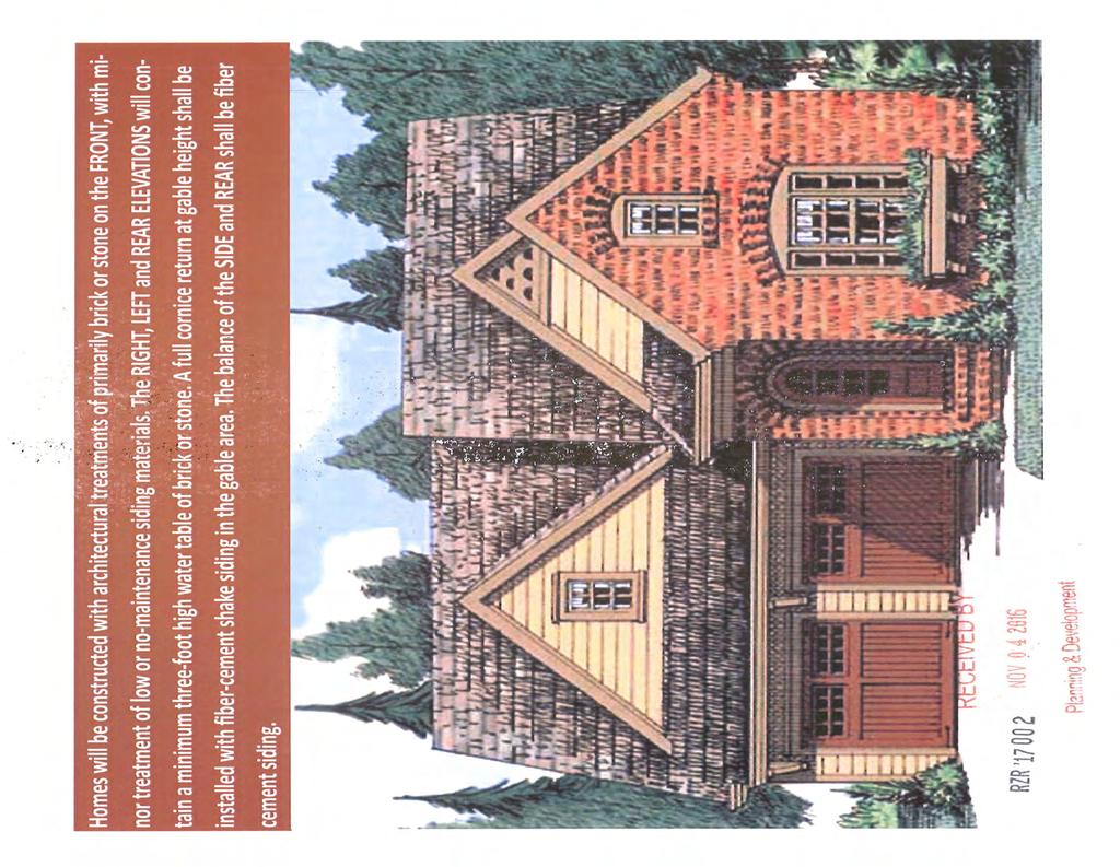
148

149 I I - E c: QJ 0.a.r:. u ro ~ -.r:. ~ V')... ~ "' z z.r:. 0 a:: 0 u..r:. QJ.~ ~ QJ > - QJ.r:. LLJ.a... _, ro 0 a::... QJ <C ro c: LLJ c: 0 ~... a:: :l -c... ~ c: QJ c: LLJ bd "' 0 ro ~ ~ 1- QJ u u. u -... "' ro... "' "' c:.:::: """ QJ E... ~... ro u ro E.:::: ' QJ 0.:::: LLJ c:.a _, ~ 0 > 1-' u -.:::: :I: ro c:j -:l. E a:: - '+- <C -~ QJ. ~.,, c..r:. QJ '+- 1- o. c: 0 QJ.a bd '+-... """ c: - 0 ro - -c QJ :l """ u;....a - u QJ ro QJ u...."!:::! c: ro """ QJ.r:. c:... u ro QJ """ ro... c: ~.r: ro.r:. bd ~ E.r:. - I -c 0... QJ c: ~ u '+- 0 I :l QJ... """ ~ QJ 0 "' c: -.r:. """ 0 '+-... u 0 E QJ... :l..c c: QJ E - E -... ro - QJ E "' QJ """ ro E... c: 0 """ 0 - :I: c:... ro ~ c: ~ QJ.a \1: QJ.a - ro.r:. "' a:: <C LLJ a:: -c c: ro LLJ c - V'). QJ QJ bd.r:.... ro '+- ~ 0 ro bd QJ u QJ c:.r:. ro... - QJ ro.a > 0 QJ.a.r:. ro 1-. c: ro 0 QJ.p """ ro c. 0 QJ -.a E ro 0 bd 0 QJ """.r:. :l... "' c: c: 0 -.a bd c:.r:. -c -... ~ u; QJ ~ "' QJ ro E.r: "'.r:. c: > ~ QJ 0 E... QJ u I "' QJ bd """ QJ c:.a \1: Vi..r:. bd... c: ~ - -c u; -c... QJ c: ro QJ... E QJ "' c: u z 0 z c -'- ~ >- (l) 0 w > -w u w cr. :..:::. 0 ::z z 0 c.. 0 ~ Q) 0 ~ 0) c: c: C\l Q_ C\J CJ t a:: N c::
150 :..~,.. Large canopy trees spaced randomly ---"""'~ Large evergreen trees spaced randomly Small ornamental trees spaced randomly Large Evergreen shrubs spaced 6' on center 20' - 25 ' T roes 10 - IS' Trees 5' - 6' S hrub~ 3' - 4' Shrubs I z ~~ Llf-l _l ~ 6-foot high Ornamental Picket Fence SmaJ I,..,..~rergreen shrubs... l J 1 spaced 4' on center I (J} c L IV r l ~ Groun<ietJ\1\El.r or Turf 6-foot high Ornamental Picket Fence _ '!.ope,j!x Line 15' Landscaped Buffe r R:=CE:V~~ ~ - j 0 ) ')"!If" l ~v. 'x &..U.a~ Plar.ning & Dov0lopment RZR '
151 5-56 NORTH RD PHARRS RD 5-73 SETH WAY HUTTON DR 5-89 LOU CT CONE CIR WINDBURN CT WORTHY CT PINELLA DR BE NNET T RDG 5-57 COLLINSWOOD DR LASHLEY CT BENT TRL HILLSWAY HIGHRIGGS LN WICKLIFFE ENGLEWOOD WAY LONG ST TOWN PL DRIFTWOOD PL PL DEERFIEL D RUN FABERSHAM DR 5-71 SNELLVILLE 5-72 LITTLE LISA LN ROSIE LN CAROLINA WIND CT PINEHAVEN DR PINEHAVEN CT RIDGEDALE DR PINELLA CT RIDGE FOREST LN PINEBARK CT 5-90 PINEHURST RD TIMBER LN CHANCELLOR CT PINEHURST LN ME ADOW DR WINDSOR LN MEADOW CREST TER WINDSOR DR WINDSOR CT 5-58 KIMBERLEY WAY RZR Printed: November 7, 2016 MEADOW HURST LN EASTGATE DR AMBER WOODS DR VALLEY CREEK CIR RIDGEWOOD WAY Feet R OX B ORO CHAPARRAL DR DR JUNES CT RADBURY LN AUTUMN DR 5-59 SYCAMORE DR THREE BARS DR TUFTSTOWN CT WINDRUSH WAY 5-70 TRILLIUM VIEW DR WINDRUSH GLENEDEN CT CT POTOMAC VIEW CT TERRY MILL LN GRAYSON PKWY N CRESTVIEW DR TURTLE SEA TURTLE LN TER FALCON RIDGE DR HAYNES CLU B CIR BROCKLIN DR 5-91 BROCKLIN LN FALCON LN
 E ~ n q 0 <U w \"\"' > 0 () > o. ~ UJ > C) 0 0 z. : t w c:- ~ ro CL I 0 ----1 ~~ ~~8~!")
152 ~S - ~ 03SOdO~d 1181HX3 3NOZ3~ '<19 'AlNnO:J illnnim':j ~a 31'<103901~ SLlC::: l:ji~lsio ONV'l HlS 'I L 101 ONV'l gg ~lii!lll /./ / / q c;, n _n _j _n _ U_ U i~! I 1 i t( : ~" ct'. ~ - ~ ~--- = : ~ -c: tl ~-:~ { >- ~ ub 0 ~ (l) E ~ n q 0 <U w ""' > 0 () > o. ~ UJ > C) 0 0 z. : t w c:- ~ ro CL I ~~ ~~8~!illii LITTLE USA LANE ----'1 "- ' "- "- "- "- "- "- "- "- I \ "- \ "-",: ~\
153 RIDGEDALE DR PINEHURST RD RZR Printed: November 7, Feet CAROLINA WIND CT
154 ROSIE LN 5-72 LITTLE LISA LN PINEHURST RD R100MOD 5-57 R100 RIDGEDALE DR 5-71 PINEHAVEN DR RS SNELLVILLE RS150 PINEHAVEN CT RZR CHAPARRAL DR TUFTSTOWN CT GLENEDEN CT Printed: November 7, Feet
155 GWINNETT COUNTY DEPARTMENT OF PLANNING AND DEVELOPMENT CHANGE IN CONDITIONS ANALYSIS CASE NUMBER :CIC ZONING :C-2 LOCATION :1500 BLOCK OF INDIAN TRAIL LILBURN ROAD MAP NUMBER :R ACREAGE :1.00 ACRE PROPOSAL :CHANGE IN CONDITIONS OF ZONING COMMISSION DISTRICT :(1) BROOKS FUTURE DEVELOPMENT MAP: REGIONAL MIXED-USE APPLICANT: WILWAT PROPERTIES, INC MONROE DRIVE NE ATLANTA, GA CONTACT: LEE FREEMAN PHONE: OWNER: GREATER ATLANTA CHRISTIAN SCHOOLS, INC INDIAN TRAIL LILBURN ROAD NORCROSS, GA DEPARTMENT RECOMMENDATION: APPROVAL WITH CONDITIONS CHANGE IN CONDITIONS SUMMARY: The applicant requests a Change-in-Conditions of a previous rezoning case, RZ-96-88, to amend the condition of zoning limiting the number of full access curb cuts along Indian Trial - Lilburn Road and Oakbrook Parkway extension. The 1.00-acre property is located along the northeast side of Indian Trail - Lilburn Road, just southeast of its intersection with Oakbrook Parkway. The site is located within the mixed-use commercial and office development known as Indian Brook Park. The subject property consists of a parking lot and it is the intention of the applicant to develop the site with a 2,200 square foot freestanding Starbuck s restaurant and drive-through. The request is to modify condition 2.B. of RZ-96-88, which reads as follows: 2.B. No more than three full access curb cuts on Indian Trial Road, including the Oakbrook Parkway extension. One shall be at the southerly end of the property, and one shall be aligned with the traffic signal for Greater Atlanta Christian School, subject to the approval of the Development Division and the Gwinnett County Department of Transportation. Two additional right-in/right-out only curb cuts may permitted, with the location subject to Development Division approval, that will provide internal access to the proposed development.
156 CIC (TH) This segment of the Indian Trail - Lilburn Road corridor consists of a multi-lane highway with a center turn lane. Access to the property is through an interparcel access easement, served by a shared driveway aligned with a traffic signal at the main entrance of the Greater Atlanta Christian School. The submitted site plan indicates that the proposed driveway would allow direct access onto Indian Trail - Lilburn Road. Additionally, the submitted plan proposes the removal and relocation of two curb cuts, to the rear of the site, along the interparcel access easement and replacing interparcel access to the subject property with one single point of access located to the rear of the site. The Gwinnett County 2030 Unified Plan Future Development Map indicates the property lies within a Regional Mixed-Use Character Area. Policies for this character area support certain freestanding retail establishments; therefore the proposed curb cut may ensure the success of the proposed restaurant and thus be in line with policy recommendations for the Regional- Mixed Use Character Area. The Indian Trail - Lilburn Road corridor is developed with a mix of commercial/retail and office-institutional uses, with residential developments located beyond the commercial corridor. Commercial activity in the area includes restaurants, retail centers, and office buildings, which all have multiple access points along Indian Trail Lilburn Road. The neighboring Greater Atlanta Christian School, in conjunction with the Gwinnett Village CID and other property owners in the area, have made substantial investments to improve the appearance and viability of the corridor. The proposed additional curb cut would be in line with these efforts as it could enhance future growth at this location. The proposed change in conditions could be consistent with policies of the Gwinnett County Unified Development Ordinance and local efforts to refine a longer-term vision of balance along the Indian Trail Lilburn Road corridor. Therefore, the Department of Planning and Development recommends APPROVAL WITH CONDITIONS. ZONING HISTORY: The property was zoned R-75 (Single Family Residence District) in In 1972, the property was rezoned to RA-200 (Agriculture-Residence District) as part of an area wide rezoning. The site was rezoned to C-2, pursuant to RZ-96-88, in GROUNDWATER RECHARGE AREA: The subject property is not located within an identified Significant Groundwater Recharge Area. 2
157 CIC (TH) WETLANDS INVENTORY: The subject property does not contain areas, streams, and/or bodies of water depicted as wetlands on the U.S. Department of Interior, Fish, and Wildlife Service National Wetlands Inventory map on file with the Gwinnett Department of Planning and Development. OPEN SPACE AND GREENWAY MASTER PLAN: No comment. DEVELOPMENT REVIEW SECTION COMMENTS: The Buffer, Landscape and Tree Protection Section of the Unified Development Ordinance (Chapter 620) requires a ten-foot wide landscape strip adjacent to all street rights-of-way for non-residential developments. The Buffer, Landscape and Tree Protection Section of the Unified Development Ordinance (Chapter 620) requires submittal and approval of a Tree Preservation and Replacement Plan prepared by a professional landscape architect prior to securing a Land Disturbance or Development permit. Parking lots and interior driveways shall be designed in accordance with Chapter 240 of the Unified Development Ordinance. Section of the Unified Development Ordinance requires a 200-foot deceleration lane with a 50-foot taper at each project entrance that proposes access to a Minor Collection Street or Major Thoroughfare. Right-of-way dedication to accommodate the deceleration lane and an 11-foot shoulder is also required. Reduction in length of a deceleration lane requires approval of a Modification by the Development Division; elimination of a deceleration lane requires approval of a Waiver by the Board of Commissioners. Section of the Unified Development Ordinance requires construction of five-foot wide sidewalks along all exterior roadways adjoining the project, and four-foot wide sidewalks adjacent to both sides of all interior public streets (excluding cul-de-sac turnarounds). Section of the Unified Development Ordinance requires submittal of a Specimen Tree Concept Plan and Tree Survey prior to submittal and acceptance of a Development Permit Application. The developer must submit detailed site development plans, including a landscape and tree preservation/replacement plan, for review and approval of the Development Division prior to any construction. 3
158 CIC (TH) Section of the Unified Development Ordinance requires submittal of a Stormwater Management Report for the project prior to obtaining a Land Disturbance or Development Permit. Section B of the Unified Development Ordinance requires that the lowest floor including the basement, of all non-residential building be constructed at an elevation of at least one foot above the 100-year floodplain. STORMWATER REVIEW SECTION COMMENTS: No comment. GWINNETT COUNTY DEPARTMENT OF TRANSPORTATION COMMENTS: Indian Trail is a Major Arterial and 50 feet of right-of-way is required from the centerline, with 60 feet required within 500 feet of a major intersection. Commercial entrances shall be provided to the site per current development regulations. Standard deceleration lane with appropriate taper and adequate right-of-way will be required. The developer shall be limited to one curb cut. There is a Gwinnett DOT (F /Georgia DOT (PI# ) project to install a multiuse path along Indian Trail Road. The Developer will be required to install the multiuse path along the frontage where this parcel intersects Indian Trail Road and will also be required to dedicate at no cost to the department the additional Right of Way needed for the improvements. Contact Gwinnett County Project Manager Tashaya Jackson at GWINNETT COUNTY ENVIRONMENTAL HEALTH COMMENTS: No comment. GWINNETT COUNTY DEPARTMENT OF WATER RESOURCES COMMENTS: The available utility records show that the subject development is currently in the vicinity of a 12-inch water main located on the northeast right-of-way of Indian Trail Lilburn Road. Due to the uncontrollable variables, the Department of Water Resources makes no guarantees as to the minimum pressures or volumes available at a specific point within its system. Demands imposed by the proposed development may require reinforcements or extensions of existing water mains. Any cost associated with such required reinforcements or 4
159 CIC (TH) extensions will be the responsibility of the development and will not be provided by this department. The available utility records show that the subject development is currently in the vicinity of an eight-inch sanitary sewer main located on parcel R The subject development is located within the Beaver Ruin service area. There are currently no connection restrictions within this service area. Treatment capacity within this area is presently available on a first come - first serve basis. Demands imposed by the proposed development may require reinforcements or extensions of existing sewer mains. Any cost associated with such required reinforcements or extensions will be the responsibility of the development and will not be provided by this department. Developer shall provide easements for future sewer connection to all locations designated by DWR during plan review. As-built information for this department is dependent upon outside entities to provide record drawings for the utilities. Therefore this department does not guarantee the accuracy of the information provided. Extensions of the water and/or sanitary sewer systems within the subject development must conform to this department s policies and Gwinnett County s ordinances. Proceeding design, construction, inspection, and final acceptance of the required utilities, service to these utilities would then become available under the applicable utility permit rate schedules. BUILDING CONSTRUCTION SECTION COMMENTS: Building Plan Review has no objections under the following conditions: 1. The applicant shall submit civil site drawings to Building Plan Review for review and approval. 2. The applicant shall submit architectural, structural, mechanical, electrical and plumbing drawings for each building for review and approval by Building Plan Review. 3. Each building shall comply with the height and area limitations of Table 503 and the fire resistive and horizontal separation requirements of Table 601 and 602 of the 2012 International Building Code with Georgia state amendments based on occupancy group classification, type of construction, and location of each building from property lines and other buildings. 4. Architectural design of the proposed building shall incorporate the requirements of the Gwinnett County Unified Development Ordinance, Architectural Design Standards, Category 1. 5
160 CIC (TH) 5. Upon completion of plan review approvals, the applicant shall obtain a building permit for each building and achieve satisfactory field inspections for issuance of a Certificate of Occupancy. For assistance, you may contact this office at Monday through Friday from the hours of 8:00 a.m. to 5:00 p.m. GWINNETT COUNTY FIRE SERVICES COMMENTS: No comment. 6
161 CIC (TH) PLANNING AND DEVELOPMENT DEPARTMENT RECOMMENDED CONDITIONS Approval as C-2 (Change-in-Conditions) subject to the following enumerated conditions: RZ Additions in bold Deletions in strikethrough 1. To restrict the use of the property as follows: A. For the property zoned O-I: Office, institutional, public and semi-public uses, which may include a retirement community or other special uses if approved for a Special Use Permit, and accessory uses at a maximum density of 15,000 square feet of gross floor area per acre zoned. B. A Special Use Permit is approved for the O-I zone property to permit a building height increase not to exceed six stories. C. For the property zoned C-2: Office, retail and service commercial and accessory uses at a maximum density of 10,000 square feet of total floor area per acre zoned. 2 To satisfy the following site development considerations: A. Provide a ten-foot wide landscape strip outside the new dedicated rights-of-way of Indian Trail Lilburn Road, Hillcrest Road and the Oakbrook Parkway extension ( except for approved access points). B. No more than three five full access curb cuts on Indian Trail Lilburn Road, including Oakbrook Parkway. One shall be a the southerly end of the property, and one shall be aligned the traffic signal for Greater Atlanta Christian School, subject to approval of the Development Division and the Gwinnett County Department of Transportation. Two additional right-in/right-out only curb cuts may be permitted, with the location subject to the Development Division that will provide internal access to the proposed development. C. No more than one exit/entrance on Hillcrest Road. D. Exits/entrances on the Oakbrook Parkway shall be in accordance with Gwinnett County Development Regulations, subject to the approval of the Development Division. E. Provide interparcel access to out parcels, location subject to the approval of the Director of Planning and Development. 7
162 CIC (TH) F. No billboards are permitted. G. Dumpsters shall be screened by a fence or wall. H. Buildings shall be finished with architectural treatments of glass and/or brick, stone, stucco or other masonry finish; or submit alternate architectural plans for approval of the Planning Commission prior to issuance of building permit. I. The 75-foot buffer on the C-2 zoned out parcels adjacent to Tract III (zoned RA- 200) may be reduced to a ten-foot wide landscape strip. 3 To abide by the following requirements, dedications and improvements: A. The Developer shall install a multiuse path along Indian Trail - Liburn Road and dedicate at no cost to the county all Right-of-Way needed for Gwinnett DOT project F and Georgia DOT project PI# Dedicate, at no cost to Gwinnett County, 60 feet of right-of-way from the centerline of Indian Trail Road. B. Dedicate, at no cost to Gwinnett County, 40 feet of right-of-way from the centerline of Hillcrest Road. C. Dedicate, at no cost to Gwinnett County, 120 feet of right-of-way for the Oakbrook Parkway within 500 feet of its intersection with Indian Trail Road and 100 feet of right-of-way through the remainder of the property. D. Improve Hillcrest Road along the entire property frontage a distance of 26 feet from centerline to back of curb prior to issuance of a certificate of occupancy for Tract II. E. Construct the Oakbrook Parkway extension, for a distance of approximately 815 feet, from Indian Trail Road with five lanes (two through lanes in each direction with a two-way left turn lane), plus left and right turn lanes at its intersection with Indian Trail Road. Construction of the road through the property to the northeasterly property line must be completed at the developer s expense prior to the issuance of any certificate of occupancy on Tract II. F. Widen, curb and gutter Indian Trail Road the width of one additional lane across the entire property frontage. G. Participate in the design and construction of the following improvements, at a cost not to exceed $175,860. Funds shall be cash escrowed with the Gwinnett Department of Transportation prior to issuance of a development permit. 8
163 CIC (TH) 1. Escrow $64,800 to participate in the cost of adding an eastbound lane on Indian Trail Road beginning 200 feet east of the easternmost project entrance and ending at the I-85 entrance ramp. 2. Escrow $92,260 to participate in the cost of adding a westbound land on Indian Trail Road from I-85 northbound exit ramp to Singleton Road. 3. Escrow $9,800 to participate in the cost of adding an additional right turn lane to I-85 northbound exit ramp. 4. Escrow $10,000 to participate in the cost of upgrading signalization on Indian Trail Road at the Oakbrook Parkway extension. 5. Funds escrowed may be used, at the option of the Gwinnett County Department of Transportation, to complete the construction of the Oakbrook Parkway extension from the northeasterly property line of Tract I to Hillcrest Road. 9
164 CIC (TH) PLANNING AND DEVELOPMENT DEPARTMENT RECOMMENDATIONS STANDARDS GOVERNING EXERCISE OF ZONING SUITABILITY OF USE The requested Change in Condition to allow an additional curb cut along Indian Trail-Lilburn Road may be suitable at this location in light of ongoing revitalization efforts to attract quality commercial developments in the area. ADVERSE IMPACTS With the current level of commercial activity along the Indian Trail-Lilburn Road corridor, the change in conditions and proposed use would not have adverse impacts on the surrounding commercial, institutional, and light industrial activities in the immediate area. REASONABLE ECONOMIC USE AS ZONED The property has a reasonable economic use as currently zoned. IMPACTS ON PUBLIC FACILITIES Additional impacts could be anticipated on public facilities in the form of traffic entering and exiting Indian Trail Lilburn Road. CONFORMITY WITH POLICIES The property is located along an established commercial corridor, surrounded by other commercial, institutional, and light industrial activities. The addition of a curb cut and freestanding commercial establishment at this location may be consistent with ongoing private and public efforts to improve the appearance and viability of the Indian Trail - Lilburn Road corridor. CONDITIONS AFFECTING ZONING A freestanding restaurant with drive-through is a permitted use under the current zoning of the property, and in the Department s opinion allowing an additional curb cut for such a development along Indian Trail-Lilburn Road would allow for a compatible use of the property with surrounding developments in the area. 10

165 Gwinnett County Planning Division Change in Conditions Application Last Updated 12/2015 CHANGE IN CONDITIONS APPLICANT'S RESPONSE STANDARDS GOVERNING THE EXERCISE OF THE ZONING POWER PURSUANT TO REQUIREMENTS OF THE UNIFIED DEVELOPMENT ORDINANCE, THE BOARD OF COMMISSIONERS FINDS THAT THE FOLLOWING STANDARDS ARE RELEVANT IN BALANCING THE INTEREST IN PROMOTING THE PUBLIC HEALTH, SAFETY, MORALITY OR GENERAL WELFARE AGAINST THE RIGHT TO THE UNRESTRICTED USE OF PROPERTY AND SHALL GOVERN THE EXERCISE OF THE ZONING POWER. PLEASE RESPOND TO THE FOLLOWING STANDARDS IN THE SPACE PROVIDED OR USE AN ATTACHMENT AS NECESSARY: (A) WHETHER A PROPOSED CHANGE IN CONDITIONS WILL PERMIT A USE THAT IS SUITABLE IN VIEW OF THE USE AND DEVELOPMENT OF ADJACENT AND NEARBY PROPERTY: The proposed Change in Conditions will permit a commercial use that is suitable as the current zoning is C-2 and adjacent zoning is C-2 and M-1. (B) WHETHER A PROPOSED CHANGE IN CONDITIONS WILL ADVERSELY AFFECT THE EXISTING USE OR USABILITY OF ADJACENT OR NEARBY PROPERTY: The proposed change positively affects the existing use allowing for better access to the property. (C) WHETHER THE PROPERTY TO BE AFFECTED BY A PROPOSED CHANGE IN CONDITIONS HAS REASONABLE ECONOMIC USE AS CURRENTLY ZONED: The Property currently has little economic use. The Change in Conditions will allow for direct access off Indian Trail Lilburn Road which will positively affect th e economic use. (D) WHETHER THE PROPOSED CHANGE IN CONDITIONS WILL RESULT IN A USE WHICH WILL OR COULD CAUSE AN EXCESSIVE OR BURDENSOME USE OF EXISTING STREETS, TRANSPORTATION FACILITIES, UTILITIES, OR SCHOOLS: The Proposed Change in Conditions will allow for easier access to the site, resulting in less burdensome use of existing streets. (E) WHETHER THE PROPOSED CHANGE IN CONDITIONS IS IN CONFORMITY WITH THE POLICY AND INTENT OF THE LAND USE PLAN: It is in conformity as the zoning and use will remain as it currently is zoned. (F) WHETHER THERE ARE OTHER EXISTING OR CHANGING CONDITIONS AFFECTING THE USE AND DEVELOPMENT OF THE PROPERTY WHICH GIVE SUPPORTING GROUNDS FOR EITHER APPROVAL OR DISAPPROVAL OF THE PROPOSED CHANGE IN CONDITIONS: N/A OCT CIC ' Plan ing ve\ pment
166 DOULGERAKIS CONSULTING ENGINEERS, INC. October 27, 2016 Change in Conditions Application Letter of Intent for 1528 Indian Trail Lilburn Road Parcel# Zoning Case RZ Doulgerakis Consulting Engineers, Inc. submits this Change in Conditions Application on behalf of Wilwat Properties, Inc. ("the Applicant") for property at 1528 Indian Trail Lilburn Rd. The property is owned by Greater Atlanta Christian Schools, Inc ("GAC"). The gross and net area of the property is 1.00 acre and it is currently zoned C-2 for general commercial retail use pursuant to zoning case RZ Said zoning case limits the number of curb cuts onto Indian Trail Rd. The applicant purposes a change in conditions to add one additional full access curb cut at 1528 Indian Trail Lilburn Rd. Currently the property is utilized as an excess parking lot with 77 spaces for the adjacent 1500 GAC Center office building at 1500 Indian Trail Lilburn Road. The Applicant proposes to redevelop a portion of the existing parking lot with a freestanding Starbucks restaurant and drive-thru. The gross building area and approximately 2,200 square feet, therefore the proposed density in terms of gross square footage per acre will be approximately 2,200 SF/acre. The building will be one story with an approximate height of25 ft. The proposed number of parking spaces is 44. The proposed change in condition is needed to increase the economic use of the property and allow for easier access to the proposed restaurant. The Applicant and his representatives welcome the opportunity to meet with the Gwinnett County Planning and Development Department staff to discuss the project and address any questions. Thank you for your consideration. Sincerely, ~ Emmanuel Doulgerakis, P.E. Representative of the Applicant CEIVED Y ICT tanning Devel pment CIC '17QO1 400 Abbey Court, Alpharetta, GA (770) Fax (770) Page 1 of 1
167 ... ' ~ '..,.,.,. BOARD OF COMMISSIONERS GWINNETT COUNTY LAWRENCEVILLE, GEORGIA RESOLUTION READING AND ADOPTION: At the regular meeting of the Gwinnett County Baaed of Commissioners held in the ~ustice and Administration Center Auditorium, 75 Langley Drive, Lawrenceville, Georgia. VOTE Lillian Webb, Chairman Ken Suffridge, District 1 Scott Ferguson, District 2 Mike Becg, District 3 Don Loggins, District 4 AYE ~IE'. AYE AYE AYE ,. ' On motion of Q~~~-~QQQl~~---- the following resolution was adopted: which carried -~=Q- A RESOLUTION TO AMEND THE OFFICIAL ZONING MAP WHEREAS, the Municipal-Gwinnett County Planning Comml.ssion has held a duly advertised public hearing and!1as ( i l_ r:; d a f o r m~a l r e c om m '2 n d a t i <,) n ~; i!.: h t h (~ G w i n n c t t Co u n t y n r:o a r d of- C(Jmmis:si.oners upon an /\ppli.cat i-: n to /\mend the Otfici.:\l. l.oni_n9 Map (:com l\a to ---~=~-~~Q_Q:~
168 ~'?Ii... ~ '...,~ :1(- for the proposed use of ~!~ Q=g~ _fq~~ gff~~lqii!f _Q Y ~Q~~ ~! '.. ~~ -~-!~f~gqfqq_g!~f~_f Q! g~-~- on a tract of land described by the attached legal description, which is incorporated herein and,.,.. made a part hereof by reference; and WHEREAS, notice to the public regarding said Amendment to the Official Zoning Map has been duly published in THE ~ GWINNETT DAILY NEWS, the Official News Organ of Gwinnett County; and WHEREAS, a publie hearing was h~ld by the Gwinnett County Board of Commissioners on -----~ggg~!_.?.l.r._12... and objections were --~Q! filed; NOW, THEREFORE, BE IT RESOLVED by the Gwinnett County Board of Commissioners this the _.?.lgq_ day of ----~gqg! 1988 that the aforesaid application to amend the Official Zoning Map from RA-200 is hereby APPROVED as C-2 for Tract I and O-I with a Specia1 use Permit 'for Tract II as shown on the Rezoning Plan for Indian Brook Park/Hendon Properties by Harris Engineering Corporation, dated and received by the Planning Division August 1, 1988, subject to the following enumerated conditions: 1.. To restri~ t the use of the property as follows: 7> A. For the property zoned 0-I: Office, institutional, public and semi-public uses, which may include a retirement community or otl1er special uses if approved for a Special Use Permit, and accessory uses Llt a maximum density of 15,000 square feet of gross floor area per acre zoned.
169 1ll B. A Special Use Permit is approved for the 0-I zoned property to permit a building height increase not to exceed six stories. C. For the property zoned C-2: Office, retail.a.1\d service commercial and accessory tises at a maximum density of 10,000 square feet of total floor area per acre zoned. 2. Ter' satisfy the following site development considerations: A. Provide a ten~foot wide landscape strip outside the new dedicated rights-of-way of Indian Tra~l Road, Hillcrest Road and the Oakbrook Parkway extension (except for approved access points). ~ B. No more than thlee ftill access curb cuts on'indian Trail Road, including the Oakbrook Parkway extension. One shall - be at the southerly end of the property, and one shall be aligned with the traffic signal for Great~~ Atlanta Christian School, stibject to.approval of the Development Division and the Gwinnett County Department of Transportation. Two additional right-in/right-out only curb cuts may be permitted, with the location subject to Development Division a~proval, that will provide internal access to the proposed development. C. No more than ~ne exit/entrance on Hillcrest Road. D. Exits/entrances on the Oakbrook Parkway extension shall be in accordance with the Gwinnett County Development Regulations, subject to the approval of the Development Division. E. Provide interparcel access to out parcels, location subject to the approval of the Director of Planning and Development. F. No billboards are permitted. G. Dumpsters shall be screened by a fence or wall. H. f) I. Buildings shall be finished with architectural treatments of glass and/or brick, stone, stucco or other masonry finish; or submit alternate architectural plans for approval of the Planning Commission prior to issuance of a building permit. The 75-foot buffer on the C-2 zoned out parcels adjacent to Tract III (zoned RA-200) may be reduced to a ten-foot wide landscape strip.
170 . ~.. ; )O ~ (. _,Ii,) 3. To ~bide by the followirig requirements, dedications and improvements: A. B.,.,.,. c. Dedicate, at no cost to Gwinnett County, 60 feet of rightof-way from the centerline of Indian Trail R'o';:,d. Dedicate, at no cost to Gwinnett County, 40 feet of rightof-way from the centerline of Hillcrest Road. Dedic te, at no cost to Gwinnett County, 120 feet of' right-of-way for the extension of Oakbrook Parkway within 500 feet of its intersection with Indian Trail Road and 100 feet of right-of-way through the remainder of the - property. D. Improve Hillcrest Road along the entire pro~e~ty frontage a distance of 26 feet from centerlin.e to back of curb prior to the is~uance of a cettificate of occupancy for Tract II. E. Construct the Oakbrook Parkway extension, for a distance of approximately 815 feet, from Indian Trail Road with five lanes (two through lanes in each direction with a two-way left turn lane), plus left and right turn lanes at its intersection with Indian Trail Road. Construction of the road through the property to the northeasterly property line must be completed at the developer's expense prior to the issuance of any certificate of occupancy on Tract II.. " F. Widen, curb and gutter Indian Trail Road the width of one additional lane across the entire prop~rty frontage.. "' G. Participate in the design and construction of the following improvements, at a cost not to exceed $175,860. Funds shall be cash escrowed with the Gwinnett Department of Transportation prior to issuance of a development permit. 1. Esctow $64,800 to participate in the cost of adding an eastbound lane on Indian Trail Road beginning 200 feet east of the easternmost project entrance and ending at the I-85 entrance ramp. 2. Escrow $92,260 to participate in the cost of adding a westbound lane on Indian Trail Road from t!1e I-85 northbound exit ramp to Singleton Road.
171 CASE NUMBER --~~:::2_.;: _,- 3. Escrow $9,800 to participate in the cost of adding an additional right turn lane to the I-85 northbound exit ramp. 4. Escrow $10,000 to participate in the cosf: of upgrading signalization on Indian Trail Ro d at the Oakbrook Parkway extension. / Funds escrowed may be used, at the option of the Gwinnett County Department of Transportation, to complete the construction of the Oakbrook Parkway extension from the northeasterly property line of Tract I to Hillcrest Road. GWINNETT COUNTY BOARD OF COMMISSIONERS By: ~~--id_)_~ Lillian Webb, Chairman RECORDED: ~~fl
172 NORCROSS GOSHEN SPRINGS RD I85S DAVID ST GOSHEN SPRINGS RD FIG ST ADAM ST BOAZ ST EZRA ST I85N MAIN CIR W MAIN ST COVE CREEK CIR WIL L OW OA K WILLOW TRAIL TRL PKWY INDIAN BROOK WAY HILLCREST RD JEURGENS CT OAKBROOK PKWY GEORGIA BELLE CT TREE TRAIL PKWY WOODBIN DR OAK LOCH TRCE ROBIN HILL DR ROMAN POINT DR SILVER LAK E DR KINGS RIDGE DR CIC Printed: November 7, 2016 ROBIN HILL CT REDDINGTON LN Feet COUNTRY TRCE COUNTRY DOWNS DR DOWNS LN DOWNS WAY HYDABURG LN SUGARWOOD LN HOY T AYLOR DR S ANTA ANNA DR TECH DR INDIAN TRAIL LILBURN RD SINGLETON RD STEVE REYNOLDS BLVD HILLCREST CT FARM WAY HUN TINGTON CH S WUTHERI NG W AY
173 \ ~ SITE DATA RE EIVE OCT ,o/.!;:,.I.:;:11 ",1lrEi.,. f7j.77' i ' I 1( 1 S'RFC / ~ ~ /' - ~t~:. -I. i 111 :,!l!i I il l II ~I ADDRESS: 1528 INOIAN1iRAIL lllburn RO ZONING : C2 (CASE.# RZ-96-88) GROSS AREA: 1.00 AC NET AREA: 1.00AC PROPOSED BUILDING AREA: SF EXISTING PARKING: n SPACES PROPOSED PARKING : 44 SPACES REQUIRED PARKING {1 /150 SF): 15 SPACES - NOPMrlDNOFTHESUBJECTPROPERTYUESWrTHINAflOOOZONE"Af"PER ARMWl.PNUM8ER1JIJSC0098f,!MPRfVISEDSEPTEMEER29,2006. THE ~~;;v~~fs~~:~~~~-e-x-which ISOESCRlBEDASAREALYlNG ~ OWNER: GREATER ATLANTA CHRISTI AN SCHOOLS. INC. I n0-2' DEVELOPER: WILWAT PROPERTI ES, INC. JI ~ \ c o ~ ro ~ : uf~ c:t: c w ~ W ;.. ~ B _g "' 0 ~ Q.) z w P-c CJ) 0 z F <> _J :::i ~ ~ 0 >--. (/) z E ~ ;... o ~ ci U ro _g cn 3 c ~ o < <t: w ~ s a:: 0 " _J Q.) ;... a P-c -ci i::::=::::; ::J ' o o c_ l u ~ - ~ ~,.. E-< Ql) - ~ ~ ~ H - Ql) - -0 ~ -'; H ~ ~ er> ~ ~ ~ Cti c...> ;::::::$ = -=...-. ~,.. - ~ cjj - ~ Planning & Development 16!Jl..iltilS1 1IDUl'rlf lllljtrmicjcu.lllcoolltl,f(.ij{i r;n]itog:cll'cdllll(l[(l!flr1;1f ITGl1!JJIIUill!OIAA10lUl1111litl ~ISID({ICl.D!llll~R.ttrn Q"'16.W.la?.ll1ia:m11.K~ CIC '17001 lproposedorivewavto \.GEORGIABELLf! CT '.t.-,,~ ', IND/AN TRAIL RO. - LILBURN RD. VARIABLE R/W SPEED LIMIT ~5 MPH '-_.; =;; == = =:: = ;--:: ::: = === ~ = ;;:; ::::-;;;::,' '. '",, 11 nl lq 11,, II lq,,..._:-; ::;= ::;:;;:;;_;;;;;;;:;;:;;;:;;:;::;;; ::;;;;;;;;;;; ;;;;;;; ;;;;;:.;;;;; ;:;:;;;;;;;;;;;;=::;;:~;:======~= "' I 1 " =20" 10-2& or 1 I g NOT foi CONITRUC!ION
174 INDIAN TRAIL LILBURN RD CIC Printed: November 7, Feet
175 8 RA200 C2 OAKBROOK PKWY C2 M1 Meadowcreek ES M INDIAN TRAIL LILBURN RD HILLCREST RD RA OBP C2 CIC Printed: November 7, Feet R75 RM C2 C3
176 GWINNETT COUNTY DEPARTMENT OF PLANNING AND DEVELOPMENT CHANGE IN CONDITIONS ANALYSIS CASE NUMBER ZONING LOCATION MAP NUMBER ACREAGE PROPOSAL COMMISSION DISTRICT :CIC :R-75 :2900 BLOCK OF DULUTH HIGHWAY :R A :8.55 ACRES :CHANGE IN CONDITIONS OF ZONING (BUFFER REDUCTION) :(1) BROOKS FUTURE DEVELOPMENT MAP: EXISTING/EMERGING SUBURBAN APPLICANT: ANGEL AMARO 2959 DULUTH HIGHWAY DULUTH, GA CONTACT: GEORGE AWUKU PHONE: OWNER: DULUTH SEVENTH-DAY ADVENTIST CHURCH 2959 DULUTH HIGHWAY DULUTH, GA DEPARTMENT RECOMMENDATION: APPROVAL WITH CONDITIONS CHANGE IN CONDITIONS SUMMARY: The applicant requests a Change-in-Conditions of a previous Special Use Permit case, SUP , to amend conditions of zoning relating to buffers and landscaping to facilitate the expansion of parking and facilities. The 8.55-acre property is located along the southwest side of Duluth Highway, just southeast of its intersection with Bugle Drive, near the city limits of Duluth. The Duluth Seventh-Day Adventist Church occupies the property, and the development consists of a church, school, parking lot, and accessory uses. The request is to amend condition 2.A. of SUP , which reads as follows: 2.A. Provide a 50-foot wide natural undisturbed buffer, adjacent to Elkwood Manor and Claiborne Manor subdivisions. For the remainder of the site, provide buffers adjacent to residential zoning as specified by the 1985 Zoning Resolution except for the encroachment of the parking lot and ball field as shown on the site plan submitted February 24, 1998 and for approved perpendicular access and utility crossings and replanting where sparsely vegetated. The applicant is proposing to encroach into the required buffer along the northern property line. The encroachment would include grading for the expansion to the existing parking and the addition of a fence. Additionally the applicant is proposing to encroach into the required buffer along the western property line common to B.B. Harris Elementary School. The encroachment would include grading for the proposed construction of a berm, parking, and the expansion of the existing gymnasium.
177 CIC (TH) The request is to amend condition 2.B. of SUP , which reads as follows: 2.B. Provide replanting as agreed upon by the adjacent property owners (Tommy and Nancy Knox) and the Seventh Day Adventist Church, per the terms of agreement entered as part of the rezoning and variance application (Z ). The applicant is proposing to encroach into the required buffer along the northern property line to expand parking, add additional landscaping, and construction of a fence. The 2030 Unified Plan Future Development Map indicates the property lies within an Existing/Emerging Suburban Character Area. Policies for this character area support neighborhood serving institutional facilities. Therefore, the continued use and expansion as a Place of Worship facilitated by requested change in condition change may be consistent with the policies of the Gwinnett County 2030 Unified Plan. The surrounding properties include B.B. Harris Elementary School which adjoins the subject property to the west. Surrounding the school are single-family developments zoned R-75, which includes Forest Manor, Elkwood Manor, and Claiborne Manor subdivisions. To the east, across Duluth Highway are more single-family dwellings located on large lots, and other institutional uses including a church and office buildings located within the city limits of Duluth. The Duluth Seventh-Day Adventist Church has operated from this location since 1962, with the school program being established in The two uses have expanded over the years and remain compatible with adjoining residential and institutional uses in the immediate area. With proper conditions to ensure compatibility, the proposed change in conditions could be consistent with other institutional uses along this portion of the Duluth Highway corridor. Therefore, the Department of Planning and Development recommends APPROVAL WITH CONDITIONS. ZONING HISTORY: The property has been zoned R-75 (Single-Family Residence District) since In 1992, a Special Use Permit allowing for the expansion of a private school, pursuant to SUP In 1998, a Special Use Permit allowing a buffer reduction for the expansion of a parking lot along the north (side) and west (rear) property lines. GROUNDWATER RECHARGE AREA: The subject property is not located within an identified Significant Groundwater Recharge Area. 2
178 CIC (TH) WETLANDS INVENTORY: The subject property does not contain areas, streams and/or bodies of water depicted as wetlands on the U.S. Department of Interior, Fish and Wildlife Service National Wetlands Inventory map on file with the Gwinnett Department of Planning and Development. OPEN SPACE AND GREENWAY MASTER PLAN: No comments. DEVELOPMENT REVIEW SECTION COMMENTS: The Buffer, Landscape and Tree Protection Section of the Unified Development Ordinance (Chapter 620) requires a ten-foot wide landscape strip adjacent to all street rights-of-way for non-residential developments. The Buffer, Landscape and Tree Protection Section of the Unified Development Ordinance (Chapter 620) requires submittal and approval of a Tree Preservation and Replacement Plan prepared by a professional landscape architect prior to securing a Land Disturbance or Development permit. Section of the Unified Development Ordinance requires screening of dumpsters and loading/unloading facilities. Parking lots and interior driveways shall be designed in accordance with Chapter 240 of the Unified Development Ordinance. Section of the Unified Development Ordinance requires a 200-foot deceleration lane with a 50-foot taper at each project entrance that proposes access to a Minor Collection Street or Major Thoroughfare. Right-of-way dedication to accommodate the deceleration lane and an 11- foot shoulder is also required. Reduction in length of a deceleration lane requires approval of a Modification by the Development Division; elimination of a deceleration lane requires approval of a Waiver by the Board of Commissioners. Section of the Unified Development Ordinance requires construction of five-foot wide sidewalks along all exterior roadways adjoining the project, and four-foot wide sidewalks adjacent to both sides of all interior public streets (excluding cul-de-sac turnarounds). The required rear setback of 30 feet appears to not be met. The applicant must either revise the site plan, or seek a Variance from the Zoning Board of Appeals. Provide a 20-foot natural, undisturbed buffer adjacent to residentially zoned properties. This buffer shall be increased to 50-feet in depth adjoining a detention pond and any church or 3
179 CIC (TH) recreation facilities. (Unified Development Ordinance Chapter 610, Table and Section ). Section B of the Unified Development Ordinance requires an additional five-foot setback for all structures (parking lots, driveways, detention ponds, retaining walls, etc.) adjacent to required buffers. Section of the Unified Development Ordinance requires submittal of a Specimen Tree Concept Plan and Tree Survey prior to submittal and acceptance of a Development Permit Application. The developer must submit detailed site development plans, including a landscape and tree preservation/replacement plan, for review and approval of the Development Division prior to any construction. Section of the Unified Development Ordinance requires submittal of a Stormwater Management Report for the project prior to obtaining a Land Disturbance or Development Permit. Section B of the Unified Development Ordinance requires that the lowest floor including the basement, of all non-residential building be constructed at an elevation of at least one foot above the 100-year floodplain. STORMWATER REVIEW SECTION COMMENTS: No comment. GWINNETT COUNTY DEPARTMENT OF TRANSPORTATION COMMENTS: Duluth Highway SR-120 is a State Route and Georgia D.O.T. right-of-way requirements govern. GWINNETT COUNTY ENVIRONMENTAL HEALTH COMMENTS: No comment. GWINNETT COUNTY DEPARTMENT OF WATER RESOURCES COMMENTS: The available utility records show that the subject development is currently in the vicinity of a six-inch water main located on the northeast right-of-way of Duluth Highway. The available utility records show that the subject development is currently in the vicinity of an eight-inch sanitary sewer main located on parcel R A. 4
180 CIC (TH) BUILDING CONSTRUCTION SECTION COMMENTS: Building Plan Review has no objections under the following conditions: 1. The applicant shall submit civil site drawings to Building Plan Review for review and approval. 2. The applicant shall submit architectural, structural, mechanical, electrical and plumbing drawings for each building for review and approval by Building Plan Review. 3. Each building shall comply with the height and area limitations of Table 503 and the fire resistive and horizontal separation requirements of Table 601 and 602 of the 2012 International Building Code with Georgia state amendments based on occupancy group classification, type of construction, and location of each building from property lines and other buildings. 4. Architectural design of the proposed building shall incorporate the requirements of the Gwinnett County Unified Development Ordinance, Architectural Design Standards, Category Upon completion of plan review approvals, the applicant shall obtain a building permit for each building and achieve satisfactory field inspections for issuance of a Certificate of Occupancy. For assistance, you may contact this office at Monday through Friday from the hours of 8:00 a.m. to 5:00 p.m. GWINNETT COUNTY FIRE SERVICES COMMENTS: No comment. 5
181 CIC (TH) PLANNING AND DEVELOPMENT DEPARTMENT RECOMMENDED CONDITIONS Approval as R-75 (Change-in-Conditions) subject to the following enumerated conditions: SUP Additions in bold Deletions in strikethrough 1. To restrict the use of the property as follows: A. A church and accessory uses which may include a school. 2. To satisfy the following site development considerations: A. Provide a 50-foot wide natural undisturbed buffer, adjacent to Elkwood Manor and Claiborne Manor subdivisions. For the remainder of the site, provide buffers adjacent to residential zoning as specified by the 1985 Zoning Resolution except for the encroachment of the parking lot and ball field as shown on the site plan submitted February 24, 1998 and for approved perpendicular access and utility crossings and replanting where sparsely vegetated. B. Provide replanting as agreed upon by the adjacent property owners (Tommy and Nancy Knox) and the Seventh Day Adventist Church, per the terms of agreement entered as part of the rezoning and variance application (Z ).The front facade of the sanctuary building shall be of a brick, stacked stone or wood shake finish. The balance of the building exterior may be these same finishes or fiber-cement siding. C. Parking shall be restricted to church use only. D. Provide a minimum ten-foot wide landscaped strip outside the dedicated right-of-way of Duluth Highway. E. In lieu of required 50-foot wide undisturbed buffer along portions of the northern and western property lines, provide a 20-foot wide undisturbed buffer, replanted where sparsely vegetated. Final landscape plan shall be subject to review and approval by the Director of Planning and Development. F. Provide a six-foot high opaque fence along the portions of the north property line now or formerly owned by Tommy and Nancy Knox. Landscape plan and fence materials shall be subject to the review and approval by the Director of Planning and Development. 6
182 CIC (TH) G. Natural vegetation shall remain on the property prior to the issuance of a development permit. H. Dumpsters shall be screened by a 100% opaque brick or stacked stone wall with an opaque metal gate enclosure. Hours of dumpster pick-up shall be limited to between 7:00 am and 7:00 pm. I. Outdoor lighting shall be contained in cut-off type luminaries and shall be directed in toward the property so as not to shine directly into adjacent residential properties or roadways. J. Outdoor recreation fields shall not be lighted. K. No tents, banners, streamers or roping decorated with flags, tinsel, or other similar material shall be displayed, hung, or strung on the site. No decorative balloons or hot-air balloons shall be displayed on the site. Yard and/or bandit signs, sign-walkers and sign-twirlers shall be prohibited. L. The property owner shall repaint or repair any graffiti or vandalism that occurs on the property within 72 hours. 7
183 CIC (TH) PLANNING AND DEVELOPMENT RECOMMENDATIONS STANDARDS GOVERNING EXERCISE OF ZONING SUITABILITY OF USE The requested Change in Conditions to reduce the required 50-foot wide undisturbed buffer may be suitable in light of expansion efforts of the church and its compatibility with surrounding institutional and residential uses. ADVERSE IMPACTS With the recommended conditions, no significant adverse impacts are anticipated on the surrounding area. REASONABLE ECONOMIC USE AS ZONED The property has a reasonable economic use as currently zoned. IMPACTS ON PUBLIC FACILITIES The requests would allow for expansion of the church which could be expected to result in an increase in traffic and utility demand. Creating additional paved areas and new buildings on the property could be expected to create additional impacts in the form of stormwater runoff. CONFORMITY WITH POLICIES With the recommended conditions, the request may be considered generally consistent with zoning actions taken by the Board on a portion of the property and in the vicinity, and could be compatible with policies of the 2030 Unified Plan recommending compatibility of residential uses in the area. CONDITIONS AFFECTING ZONING The current zoning conditions on the subject property were established through the public hearing process to ensure the compatibility of uses in the area. 8

184 Gwinnett County Planning Division Change in Conditions Application Last Updated 12/20 IS CHANGE IN CONDITIONS APPLICANT'S RESPONSE STANDARDS GOVERNING THE EXERCISE OF THE ZONING POWER PURSUANT TO REQUIREMENTS OF THE UNIFIED DEVELOPMENT ORDINANCE, THE BOARD OF COMMISSIONERS FINDS THAT THE FOLLOWING STANDARDS ARE RELEVANT IN BALANCING THE INTEREST IN PROMOTING THE PUBLIC HEALTH, SAFETY, MORALITY OR GENERAL WELFARE AGAINST THE RIGHT TO THE UN RESTRICTED USE OF PROPERTY AND SHALL GOVERN THE EXERCISE OF THE ZONING POWER. PLEASE RESPOND TO THE FOLLOWING STANDARDS IN THE SPACE PROVIDED OR USE AN ATTACHMENT AS NECESSARY: (A) WHETHER A PROPOSED CHANGE IN CONDITIONS WILL PERMIT A USE THAT IS SUITABLE IN VIEW OF THE USE AND DEVELOPMENT OF ADJACENT AND NEARBY PROPERTY: The use of the property will remain the same, the development is an expatiation of use permitted in previous SUP (B) (C) WHETHER A PROPOSED CHANGE IN CONDITIONS WILL ADVERSELY AFFECT THE EXISTING USE OR USABILITY OF ADJACENT OR NEARBY PROPERTY: We do not believe the change in conditions will adversely affect any neighboring propertys WHETHER THE PROPERTY TO BE AFFECTED BY A PROPOSED CHANGE IN CONDITIONS HAS REASONABLE ECONOMIC USE AS CURRENTLY ZONED: The property is a church and the change in conditions is to allow it to continue to grow as such (D) WHETHER THE PROPOSED CHANGE IN CONDITIONS WILL RESULT IN A USE WHICH WILL OR COULD CAUSE AN EXCESSIVE OR BURDENSOME USE OF EXISTING STREETS, TRANSPORTATION FACILITIES, UTILITIES, OR SCHOOLS: The change in conditions should have very little impact on the above (E) (F) WHETHER THE PROPOSED CHANGE IN CONDITIONS IS IN CONFORMITY WITH THE POLICY AND INTENT OF THE LAND USE PLAN: It is expanding on the current SUP of the property and in line with development standards WHETHER THERE ARE OTHER EXISTING OR CHANGING CONDITIONS AFFECTING THE USE AND DEVELOPMENT OF THE PROPERTY WHICH GIVE SUPPORTING GROUNDS FOR EITHER APPROVAL OR DISAPPROVAL OF THE PROPOSED CHANGE IN CONDITIONS: The property will be an expansion of intended use granted and operating under a current SUP CIC ' RECE,VED B I Planning & Development
185 E Suite 58, 5341 THOMPSON BRIDGE ROAD, MURRAYVILLE, GA TEL October 26, 2016 Board of Commissioners Gwinnett County 446 West Crogan Street Lawrenceville, Georgia Dear Board Members; Change in Conditions from SUP Parcel ID: A (2959 DULUTH HWY) Seventh-Day Adventist Church. The Applicant respectfully submits to the Board of Commissioners a request for a change in the conditions as approved under Special Use Permit (SUP) SUP provided for a reduction of buffers for the existing church expansion then. The church, since then, has seen additional growth and in anticipation of future growth prepared a master plan (as indicated on Concept Plan submitted). A change in conditions is required to allow for the modification of the site plan on record as the nature of the proposed improvement impacts stipulations agreed to in the SUP The following improvements are proposed:- Phase 1-new 2,300 SF administration building, Phase 2 - new 2, 160 SF cafeteria and storage facility addition to the existing gym building, Phase 3 - new 4,100 SF office/classrooms/locker rooms addition to the existing gym building, Phase 4-6,800 SF remolding the existing gym building, and Phase 5 -new 11,250 SF sanctuary building. The improvements also call for additional parking, improvements to the existing detention pond and new pond/playfield and landscape installation. RECEIVED B CIC ' NOV Planning & De 'elopment
186 Suite 58, 5341 THOMPSON BRIDGE ROAD, MURRAYVILLE, GA TEL Stipulation A of the approved SUP will be maintained in part. The 50-foot wide natural undisturbed buffer adjacent to Elkwood Manor and Clairbome Manor subdivisions will not be impacted. The approved 0-foot buffer along the western property line/b B Harris Elementary School will be impacted by the addition of a parking lot, using the ball field as a detention pond and an addition to the existing gym. Stipulation B of the approved SUP will be maintained. The agreed to planting per ZV will be enhanced by replanting sparsely vegetated areas and the installation of a 6- foot opaque fence. The proposed improvement will require extending the existing parking parallel and along that section of the reduced buffer. The Gwinnett County Board of Education (BOE) has been notified of the applicant's requested improvements to encroach into the rear setback line. At the time of preparing the application we are yet to hear back from them. Any information from the BOE regarding our application will be forwarded to Planning and Development Staff and Board Members. Thank you for your time and consideration of our request. The applicant is opened to working with Staff and Board Members to achieve the successful implementation of this project. Respectively Submitted, George Awuku, P.E. Design Engineer CJC ' RECEIVED 8 NO Planning & Development
187 CASE NUMBER ~S~U~P_--9~8~-~0~6~2~ READING AND ADOPTION:.. ~QM]) Q~ COMMl_SSI.ONER.8. _..... GWINNETT COUNTY LAWRENCEVILLE, GEORGIA RESOLUTION At the regular meeting of the Gwinnett County Board of Commissioners, held in the Justice and Administration Center Auditorium, 75 Langley Drive, Lawrenceville, Georgia. Present Wayne Hill, Chairman Tommy Hughes, District 1 Patti Muise, District 2 Judy Waters, District 3 Kevin Kenerly, District 4 VOTE AYE AYE AYE AYE AYE On motion of COMM. HUGHES, which carried 5-0, the following resolution was adopted: A RESOLUTION TO GRANT A SPECIAL USE PERMIT WHEREAS, the Municipal-Gwinnett County Planning Commission has held a duly advertised public hearing apd has filed a formal recommendation with the Gwinnett County Board of Commissioners upon an Application for a Special Use Permit by DULUTH SEVENTH-DAY ADVENTIST for the proposed use of CHURCH EXPANSION (REDUCTION IN BUFFERS) on a tract of land described by the attached legal description,.which is incorporated herein and made a part hereof by reference; and
188 CASE NUMBER ---=S~U~P_-~9~8_-~0~6~2~ _. WHEREAS, notj. G.~ to.. the P\iblic regc;n;ding.. s_a;id Spe.c_i_al _Us.e. Permit Application has been duly published in THE GWINNETT DAILY POST, the Official News Organ of Gwinnett County; and WHEREAS, a public hearing was held by the Gwinnett County Board of Commissioners on May and objections were not filed. NOW, THEREFORE, BE IT RESOLVED by ~he Gwinnett County Board of Commissioners this the 26th day of May 1998, that the aforesaid application for a Special Use Permit is hereby APPROVED subject to the following enumerated conditions: 1. To restrict the use of the property as follows: A. A church and accessory uses which may include a school. 2. To satisfy the following site development considerations: -A. - provide- a -50-foot wide natural undisturbed buffer, adjacent to Elkwood Manor and Claiborne Manor r subdivisions. For the remainder of the site, provide buffers adjacent to residential zoning as specified by the 1985 Zo~ing ~esolution - except - for - the - encroachment of the- parking lot and ballfield as shown on the site plan submitted February 24,1998 and for approved perpendicular access and utility crossings and replanting where sparsely vegetated.
189 CASE NUMBER SUP B Provide -replanting as ag-reed -upon -by- the -adjacent - property owners (Tommy and Nancy Knox) and the Seventh Day Adventist Church, per the terms of agreement entered as part of the rezoning and variance application (Z ). GWINNETT COUNTY BOARD OF COMMISSIONERS By: Date Signed: ~ P-f;!f'f_/ ATTEST: Dep~~C;I(~ -..
190 PEACHTREE RD HOW E LL BUFORD HWY SUNSET ST CIR SHARPTON DR HIDDEN LAKE DR PINEVIEW CIR HIGH LAND PINE WAY LORI LN WOODSTAR CT CROSS F JANNA LN IELD WAY PITTARD RD DAVE NPOR T RD ENNFIELD LN CROSSFIELD LN ENNFIELD WAY TRACE Y DR WINDSOR GATE RUN HIGHLAND PINE DR CREEK DR L ARC H CIC Printed: November 7, 2016 DULUTH PINES S ROUNDFIELD CIR DELMA CT ORONO DR PINE DR RED PINE CT HALL CIR FOX ST HERITAGE WALK LN DULUTH BROMLE Y RO W KNOTT ST MONTHEATH PASS ROLLINGB ROOK WAY Feet SUTTON PL HUXLEY CT NELSON DR STAR PINE CT MOCKINGBIRD CIR GOVERNORS CT MONTHEATH CT BLUE JAY DR CANARY LAKE DR GOVERNORS AVE SAINT ANDREWS DR DOVER CT WYESHAM CIR BRISTOL LN CARDINAL TRCE STARLING CIR ROBERTS RD DOVER DR BUGLE DR WINCHESTER CT CANARY TRL OXFORD WAY NORMAN CIR DULUTH HWY CLAIBORNE DR LONDON LN ROBIN LN LE E D CAR D INAL LA S WAY ORCHARD RIDGE CIR KENT CT MEADOW LARK DR BOB WHITE TRL K E CIR BARON ET CT BROOKSHIRE WAY SPARROW CIR HEATH LN DOGWOOD CREEK PKWY WINSTON WAY HARRIS MILL WAY SAXON DR WILLOWSTONE DR WREN AVE ORIOLE LN PREAKNESS LN W ILLOW BLUEBIRD CIR G REEN DR ASHLEY OAKS CT PADDOCK T RL S EAGUL L DR BUNTEN RD CARDINAL BOB WHITE DR GAVIN PL PARTRIDGE TRL LA KE DR DAVENTRY WALK RANKIN RUN EUDORA TRL TH URLESTON PHEASANT TRL AL N WICK DR MAJOR LN MCDANIEL RD R IDGE TRL WHIPPOORWILL CIR GREY M O SS PA S S SALEM OAK WAY 7-118
FI,ofl oprs GEORGIA CONFERENCE OF SEVENTH DAY ADVENTIST 2959 DULUTH HWY DULUTH, GA 30096 CONTACT: PASTOR AMARO TEL: 645 372 0329 ~ 5341 1HOt.4PSON BRIDGE RO SUITE 58 lr.")
191 \ Ql) / NfF \ ELKWOOD MANOR ~~ :io : ~~:=~; \ <!ll / ia PWNFR Jl)FI,ofl oprs GEORGIA CONFERENCE OF SEVENTH DAY ADVENTIST 2959 DULUTH HWY DULUTH, GA CONTACT: PASTOR AMARO TEL: ~ HOt.4PSON BRIDGE RO SUITE 58 lr.iurrayville, GA PH ' (-) CONTACT: GEORGE Av.\JKU,P.E. ! ELMINAENGINEEROGMAILCOM PARKING CALQJLATION' PLACE OF WORSHIP: 800 SEATS / ~~~N:oEt{Jg~~;;~ ~~ Jiu : ~~.;; MAX. AU.OWABLE PARKING = 800/2 = 400 SPACES MIN. AU.OWABLE PARKING = 800/S = 160 SPACES PROVIDED = 245 SPACES (WfTli 12 H/C SPACES) 33 SPACES COMPACT (13% TOTAL SPACES) ~8 ll1 ~ ~ ~ ~ ~ ~ ~ ~ ~ ~ ~ I~ u H fu~zi ~ en j tij 8 ~ IL ~ en SITE ANALYSIS 1. AREA ACRES 2. STREAM - 0 FT BUFFERS 3. WETlANDS - 0 ACRES. 4. FLOODPLAIN - 0 ACRES. ZONING DATA 1. CURRENTLY ZONED R75 2. BUIUNC SETBACK REQUIREMENTS ARE: FRONT- 50 FEET SIDES- 10 FEET REAR- 3. SUP SUP ZVR FEET SCHOOL AND GYM PHASE LEGEND' - PHASE 1 (2,500 S.F.) 1 STORY [===:::J PHASE 2 (2,160 S.F.) 1 STORY [===:::J PHASE 3 (4,150 S.F.) 2 STORY [===:::J PHASE 4 (EXISTING BUILDING) [===:::J PHASE 5 (11,250 S.F.) 1 STORY <ill \ (5) ~ NOV 2016 Planning 8.t Development \ GRAPHIC SCALE / ~.J;;J-J i T ~~~~)n. ~ ~ ~ ~ ~ EJ CIC '
192 DULUTH HWY CIC Printed: November 7, Feet CLAIBORNE DR
193 RM PRD OI OI NORMAN CIR OI LAKE VIEW DR BROOKSHIRE WAY ASHLEY OAKS CT BUNTEN RD ON R100 GOVERNORS CT GOVERNORS AVE DEVAUDEN CT PRD PRD NORMAN CIR HARRIS MILL WAY RM DELMA CT DULUTH SUTTON PL SAINT ANDREWS DR OI ON C2 PRD ORCHARD RIDGE CIR R100 PREAKNESS LN R140 PRD BROMLEY ROW HUXLEY CT MONTHEATH PASS SAINT ANDREWS WAY ROBERTS RD BUGLE DR DULUTH HWY R100 DOGWOOD CREEK PKWY WILLOWSTONE DR PADDOCK TRL ENNFIELD LN OI FAIRGREENE PL HUNTING WOOD WALK DOVER DR DOVER CT R BUNTEN RD RZT Harris ES R75MOD C2 NELSON DR CLAIBORNE DR R100 C1 BRISTOL LN LONDON LN HICKORY RUN CIR OI R75 OXFORD WAY LARCH PINE DR DAVENPORT RD STAR PINE CT R75CSO WINCHESTER CT KENT CT BOB WHITE TRL MEADOW LARK DR R100 C ROBIN LN RED PINE CT CIC MOCKINGBIRD CIR Printed: November 7, 2016 BLUE JAY DR CARDINAL TRCE Feet CARDINAL LAKE CIR BLUEBIRD CIR 7-119
194 CIC (TH) GWINNETT COUNTY DEPARTMENT OF PLANNING AND DEVELOPMENT CHANGE IN CONDITIONS ANALYSIS CASE NUMBER :CIC ZONING :M-1 LOCATION :600 BLOCK OF SATELLITE BOULEVARD MAP NUMBER :R ACREAGE :4.99 ACRES PROPOSAL :CHANGE IN CONDITIONS OF ZONING COMMISSION DISTRICT :(1) BROOKS FUTURE DEVELOPMENT MAP: PREFERRED OFFICE APPLICANT: LABEL TECHNOLOGIES INC. C/O MILL CREEK CONSULTING 4480 COMMERCE DRIVE, SUITE A BUFORD, GA CONTACT: MITCH PEEVY PHONE: OWNER: RES-GA WELLINGTON LAKE, LLC C/O MILL CREEK CONSULTING 4480 COMMERCE DRIVE, SUITE A BUFORD, GA DEPARTMENT RECOMMENDATION: APPROVAL WITH CONDITIONS CHANGE IN CONDITIONS SUMMARY: The applicant requests a Change-in-Conditions of previous Special Use Permits, SUP , and SUP , to amend the condition of zoning limiting the use of the property to a Nursing Home, Medical Center, Church, and related accessory uses. The 4.99-acre property is located along the southwest side of Satellite Boulevard, just southeast of its intersection with McGinnis Ferry Road. The site is located within the Shawnee Ridge business park, which consist of a mix of office, institutional and light industrial developments. The subject property consists of a parking lot and natural buffers to the north and west. The applicant, Label Technologies, Inc., intends to relocate their current operations and develop the site with a 22,600 square foot freestanding office/warehouse building. The Board of Commissioners approved two Special Use Permits in 2004 allowing St. Paul Coptic Orthodox Church to develop the site as nursing home, medical center, and church. In 2005, a commercial development permit (CDP ) was issued for the development of the site as originally proposed. However, the site was only partially developed, with the remainder of the project being abandoned.
195 CIC (TH) The request is to modify condition 1.A. of SUP and SUP , which reads as follows: 1.A. Nursing home, medical center, church, and accessory uses as shown on the submitted site plan dated September 3, Any daycare or private school shall require additional Special Use Permit approvals. The Gwinnett County 2030 Unified Plan Future Development Map indicates that the property lies within the Preferred Office character area. The proposed development within the Shawnee Ridge business park could be consistent with this character area, and considered compatible with the recommendations of the Gwinnett County 2030 Unified Plan. The immediate area consists of large office and light industrial uses along Satellite Boulevard. Immediately to the south is the Saint Paul Coptic Orthodox Church, the previous owner of the subject property. To the north, east and south of the subject property are office buildings zoned M-1 within the Shawnee Ridge Business Park. To the west, across Mill Creek is the R- 100 zoned Wildwoods at McGinnis Ferry single-family subdivision. The proposed building will be situated on its own parcel, with direct access to Satellite Boulevard, while being adequately separated from neighboring single-family properties with natural landscaping and buffers. The proposed use should not affect the usability of neighboring office and warehouse buildings. If properly conditioned, the proposed change in conditions to develop the site as an office/warehouse facility could be compatible with zoning and uses in the immediate area. The proposed change in conditions could be consistent with development in the immediate area, if the proposed facility is in conformity with the day-to-day operations of the neighboring use and compliant with Gwinnett County Unified Development Ordinance. Therefore, the Department of Planning and Development recommends APPROVAL WITH CONDITIONS. ZONING HISTORY: In 1970, the subject property was zoned R-100 (Single-Family Residence District). The property has been zoned M-1 (Light Industry District) since 1987, pursuant to RZ An application to rezone the property to RM-10 was denied in 1998 (RZ ). In 2004, two Special Use Permits were approved allowing a Nursing Home, Medical Center, Church, and accessory uses, pursuant to SUP and SUP , respectively. GROUNDWATER RECHARGE AREA: The subject property is not located within an identified Significant Groundwater Recharge Area. 2
196 CIC (TH) WETLANDS INVENTORY: The subject property contains areas, streams, and/or bodies of water depicted as wetlands on the U.S. Department of Interior, Fish, and Wildlife Service National Wetlands Inventory map on file with the Gwinnett Department of Planning and Development. The applicant/developer shall obtain all required approvals from the Gwinnett Department of Public Utilities and the U.S. Army Corps of Engineers for construction or land disturbance activities, which may impact floodplain or wetland areas. OPEN SPACE AND GREENWAY MASTER PLAN: No comment. DEVELOPMENT REVIEW SECTION COMMENTS: The Buffer, Landscape and Tree Protection Section of the Unified Development Ordinance (Chapter 620) requires a ten-foot wide landscape strip adjacent to all street rights-of-way for non-residential developments. The Buffer, Landscape and Tree Protection Section of the Unified Development Ordinance (Chapter 620) requires submittal and approval of a Tree Preservation and Replacement Plan prepared by a professional landscape architect prior to securing a Land Disturbance or Development permit. Section of the Unified Development Ordinance requires screening of dumpsters and loading/unloading facilities. Parking lots and interior driveways shall be designed in accordance with Chapter 240 of the Unified Development Ordinance. Section B of the Unified Development Ordinance requires an additional five-foot setback for all structures (parking lots, driveways, detention ponds, retaining walls, etc.) adjacent to required buffers. Section of the Unified Development Ordinance requires submittal of a Specimen Tree Concept Plan and Tree Survey prior to submittal and acceptance of a Development Permit Application. The developer must submit detailed site development plans, including a landscape and tree preservation/replacement plan, for review and approval of the Development Division prior to any construction. 3
197 CIC (TH) Section of the Unified Development Ordinance requires submittal of a Stormwater Management Report for the project prior to obtaining a Land Disturbance or Development Permit. Section B of the Unified Development Ordinance requires that the lowest floor including the basement, of all non-residential building be constructed at an elevation of at least one foot above the 100-year floodplain. STORMWATER REVIEW SECTION COMMENTS: No comment. GWINNETT COUNTY DEPARTMENT OF TRANSPORTATION COMMENTS: Satellite Boulevard is a Major Arterial and 50 feet of right-of-way is required from the centerline, with 60 feet required within 500 feet of a major intersection. Commercial entrances shall be provided to the site per current development regulations. Standard deceleration lane with appropriate taper and adequate right-of-way will be required. The developer shall be limited to one curb cut. GWINNETT COUNTY ENVIRONMENTAL HEALTH COMMENTS: No comment. GWINNETT COUNTY DEPARTMENT OF WATER RESOURCES COMMENTS: The available utility records show that the subject development is currently in the vicinity of a 16-inch water main located on the southwest right-of-way of Satellite Boulevard. Due to the uncontrollable variables, the Department of Water Resources makes no guarantees as to the minimum pressures or volumes available at a specific point within its system. Demands imposed by the proposed development may require reinforcements or extensions of existing water mains. Any cost associated with such required reinforcements or extensions will be the responsibility of the development and will not be provided by this department. The available utility records show that the subject development is currently in the vicinity of an eight-inch sanitary sewer main located on parcel R and a 12-inch sanitary sewer main located on parcel R
198 CIC (TH) The subject development is located within the Suwanee Creek service area. There are currently no connection restrictions within this service area. Treatment capacity within this area is presently available on a first come - first serve basis. Demands imposed by the proposed development may require reinforcements or extensions of existing sewer mains. Any cost associated with such required reinforcements or extensions will be the responsibility of the development and will not be provided by this department. Developer shall provide easements for future sewer connection to all locations designated by DWR during plan review. As-built information for this department is dependent upon outside entities to provide record drawings for the utilities. Therefore this department does not guarantee the accuracy of the information provided. Extensions of the water and/or sanitary sewer systems within the subject development must conform to this department s policies and Gwinnett County s ordinances. Proceeding design, construction, inspection, and final acceptance of the required utilities, service to these utilities would then become available under the applicable utility permit rate schedules. BUILDING CONSTRUCTION SECTION COMMENTS: Building Plan Review has no objections under the following conditions: 1. The applicant shall submit civil site drawings to Building Plan Review for review and approval. 2. The applicant shall submit architectural, structural, mechanical, electrical and plumbing drawings for each building for review and approval by Building Plan Review. 3. Each building shall comply with the height and area limitations of Table 503 and the fire resistive and horizontal separation requirements of Table 601 and 602 of the 2012 International Building Code with Georgia state amendments based on occupancy group classification, type of construction, and location of each building from property lines and other buildings. 4. Architectural design of the proposed building shall incorporate the requirements of the Gwinnett County Unified Development Ordinance, Architectural Design Standards, Category Upon completion of plan review approvals, the applicant shall obtain a building permit for each building and achieve satisfactory field inspections for issuance of a Certificate of Occupancy. For assistance, you may contact this office at Monday through Friday from the hours of 8:00 a.m. to 5:00 p.m. 5
199 CIC (TH) GWINNETT COUNTY FIRE SERVICES COMMENTS: No comment. 6
200 CIC (TH) PLANNING AND DEVELOPMENT DEPARTMENT RECOMMENDED CONDITIONS Approval as M-1 (Change-in-Conditions), allowing Light Industrial uses, subject to the following enumerated conditions: SUP & SUP Additions in bold Deletions in strikethrough 1. To restrict the use of the property as follows: A. Nursing home, medical center, church, and accessory uses as shown on the submitted site plan dated September 3, Any daycare or private school shall require additional Special Use Permit approvals. B. Buildings shall be finished with architectural treatments of brick, stacked stone, or stucco. Final building elevations shall be submitted for review by the Director of Planning and Development. 2. Satisfy the following site development considerations: A. Provide a 50-foot wide natural undisturbed buffer adjacent to residentially zoned property. B. Oversized signs shall be prohibited. C. Ground signs shall be limited to a single monument sign and shall be subject to review and approval by the Director of Planning & Development. The sign shall include with a minimum two-foot high brick base, complementing the building s architectural treatment. The masonry base shall extend at least the full width of the sign cabinet, and the sign cabinet shall be fully recessed and surrounded by the same materials. The ground sign shall not exceed six feet in height. D. Lighting shall be contained in cut-off type luminaries directed inward so as not to shine directly into residentially zoned property. Any outdoor recreation facilities shall not be lighted. E. Wall signage shall not exceed the requirements of the Gwinnett County Sign Ordinance, and shall only utilize neutral (non-white earth tone) background colors for the sign cabinet. 7
201 CIC (TH) F. Window signage (signs displayed on the interior or exterior of the business storefront windows) shall be prohibited, except for open/closed signs or signs required by county, state or federal law. Flashing or blinking signs and exposed neon or LED signs shall be prohibited. Exposed or visible lighting strips mounted on the building or around window frames shall be prohibited. G. Billboards or oversized signs shall be prohibited. H. No tents, canopies, temporary banners, streamers or roping decorated with flags, tinsel, or other similar material shall be displayed, hung, or strung on the site. No decorative balloons or hot-air balloons shall be displayed on the site. Yard and/or bandit signs, sign-walkers and signtwirlers shall be prohibited. I. Dumpsters shall be screened by a 100% opaque brick or stacked stone wall with an opaque metal gate enclosure. Hours of dumpster pick-up shall be limited to between 7:00 am and 7:00 pm. J. Lighting shall be contained in cut-off type luminaries and shall be directed in toward the property so as not to shine directly into adjacent properties or rights-of-way. K. Outdoor loudspeakers shall be prohibited. L. Peddlers and/or parking lot sales shall be prohibited. M. The property owner shall repaint or repair any graffiti or vandalism that occurs on the property within 72 hours. 3. Abide by the following requirements, dedications and improvements: A. Dedicate at no cost to Gwinnett County all necessary right-of-way and easements for the future construction of a greenway, path/trail through the property in accordance with the Gwinnett County Open Space and Greenway Master Plan. Right-ofway/easement width and location shall be subject to review and approval of the Gwinnett Department of Community Services. 8
202 CIC (TH) PLANNING AND DEVELOPMENT DEPARTMENT RECOMMENDATIONS STANDARDS GOVERNING THE EXERCISE OF ZONING SUITABILITY OF USE The proposed office and light manufacturing facility would be suitable in view of the surrounding Shawnee Ridge business park. ADVERSE IMPACTS The proposed change in conditions to allow a light industrial use is not expected to have significant adverse impacts on neighboring properties. REASONABLE ECONOMIC USE AS ZONED The subject property has a reasonable economic use as currently zoned. IMPACT ON PUBLIC FACILITIES Increased impacts on public facilities from stormwater run-off, utility demand, and traffic would be anticipated from the proposed development. CONFORMITY WITH POLICIES The request is compatible with the Gwinnett County 2030 Unified Plan, and consistent with numerous Board actions approving similar request throughout the county. CONDITIONS AFFECTING ZONING The natural buffer between the proposed development and the neighboring subdivision and property to the north gives further support for approval of this request. 9

203 STANDARDS GOVERNING EXERCISE OF THE ZONING POWER PURSUANT TO SECTION 1702 OF THE 1985 ZONING RESOLUTION, THE BOARD OF COMMISSIONERS FINDS THAT THE FOLLOWING STANDARDS ARE RELEVANT IN BALANCING THE INTEREST IN PROMOTING THE PUBLIC HEAL TH, SAFETY, MORALITY, OR GENERAL WELFARE AGAINST THE RIGHT TO THE UNRESTRICTED USE OF PROPERTY AND SHALL GOVERN THE EXERCISE OF THE ZONING POWER. PLEASE RESPOND TO THE FOLLOVVii\JG STANDARDS in THE SPACE PROViDED OR USE AN ATIACHMENT AS NECESSARY: (A) WHETHER A PROPOSED REZONING WILL PERMIT A USE THAT IS SU ITABLE IN VIEVV OF THE USE AND DEVELOPMENT OF ADJACENT AND NEARBY PROPERTY: THE APPLICANT BELIEVES THE PROPOSED USE IS SUITABLE. (B) WHETHER A PROPOSED REZONING WILL ADVERSELY AFFECT THE EXISTING USE OR USABILITY OF ADJACENT OR NEARBY PROPERTY: THE PROPOSED USE WILL NOT ADVERSELY AFFECT THE USE OF THE SURROUNDING PROPERTIES. (C) WHETHER THE PROPERTY TO BE AFFECTED BY A PROPOSED REZONING HAS A REASONABLE ECONOMIC USE AS CURRENTLY ZONED: THE APPLICANT BELIEVES THAT THE SUBdECT PROPERTY DOES NOT HA VE A REASONABLE ECONOMIC USE WITHOUT THE CHANGE IN CONDITIONS. (D) WHETHER THE PROPOSED REZONING WILL RESULT IN A USE WHICH WILL OR COULD CAUSE AN EXCESSIVE OR BURDENSOME USE OF EXISTING STREET, TRANSPORTATION FACILITIES, UTILITIES OR SCHOOLS: THE PROPOSED USE WILL NOT PRODUCE AN ADVERSE AFFECT ON THE EXISTING INFRASTRUCTURE. (E) WHETHER THE PROPOSED REZONING IS IN CONFORMITY WITH THE POLICY AND INTENT OF THE LAND USE PLAN: THE SUBJECT PROPERTY IS DESIGNATED AS PREFERED OFFICE. (F) WHETHER THERE ARE OTHER EXISTING OR CHANGING CONDITIONS AFFECTING THE USE AND DEVELOPMENT OF THE PROPERTY WHICH GIVE SUPPORTING GROUNDS FOR EITHER APPROVAL OR DISAPPROVAL OF THE PROPOSED REZONING: SEE LETTER OF INTENT. CIC ' RECE\VED BY OV f'\ann\ng & Oeve\opment
204 Kc 0NiNG AtJPLiCANT;S Lt: TTt:R Ut- INTt:N I The Applicant, Label technologies, Inc. (L Tl), requests a Change in Conditions from case SUP and 084 that restricts the use of the property at 645 Satellite Boulevard to a nursing home and a church. LTI currently leases production space in the immediate area and desires to build and own its own facility. The site is proposed to share an entrance with the church next door and with the different use times there should be very minimal traffic interaction with the 2 different uses. The applicant also proposes to provide the required 50 foot buffer adjacent to the residentially zoned property along the rear. L Tl is a specialty manufacturer of PTFE based venting products for automotive, consumer, industrial and medical devices. They currently have 16 employees and are excited to be able to find this property and be able to stay in the Gwinnett County, Suwanee area and grow their business. - CIC '17 QO 3 RECEIVED B NOV Planning & Development
205 CASE NUMBER SUP READING AND ADOPTION: BOARD OF COMMISSIONERS GWINNETT COUNTY LAWRENCEVILLE, GEORGIA RESOLUTION At the regular meeting of the Gwinnett County Board of Commissioners, held in the Justice and Administration Center Auditorium, 75 Langley Drive, Lawrenceville, Georgia. Present Wayne Hill, Chairman Marcia Neaton, District 1 Albert Nasuti, District 2 John Dunn, District 3 Kevin Kenerly, District 4 VOTE AYE AYE ABSENT AYE AYE On motion of COMM. NEATON the following resolution was adopted:, which carried ±_::_Q, A RESOLUTION TO GRANT A SPECIAL USE PERMIT WHEREAS, the Municipal-Gwinnett County Planning Commission has held a duly advertised public hearing and has filed a formal recommendation with the Gwinnett"County Board of Commissioners upon an Application for a Special Use Permit by VICTOR SAAD proposed use of NURSING HOME on a tract of land described by the attached legal description, which is incorporated herein and made a part hereof by reference; and
206 CASE NUMBER SUP WHEREAS, notice to the public regarding said Special Use Permit Application has been duly published in THE GWINNETT DAILY POST, the Official News Organ of Gwinnett County; and WHEREAS, a public hearing was held by the Gwinnett County Board of Commissioners on NOVEMBER 23 objections were not filed. NOW, THEREFORE, BE IT RESOLVED by the Gwinnett County Board ~~~~~~ of Commissioners this the 23RD day of NOVEMBER that the aforesaid application for a Special Use Permit is hereby APPROVED subject to the following enumerated conditions: 1. To restrict the use of the property as follows: A. Nursing home, medical center, church, and accessory uses as shown on the submitted site plan dated September 3, Any daycare or private school shall require additional Special Use Permit approvals. B. Buildings shall be finished with architectural treatments of brick, stacked stone, or stucco. 2. Satisfy the following site development considerations: A. Provide a 50-foot wide natural undisturbed buffer adjacent to residentially zoned property. B. Oversized signs shall be prohibited. C. Ground signs shall be limited to a single monument sign with a minimum 2-foot high brick base. D. Lighting shall be contained in cut-off type luminaries directed inward so as not to shine directly into residentially zoned property. Any outdoor recreation facilities shall not be lighted.
207 CASE NUMBER SUP Abide by the following requirements, dedications and improvements: A. Dedicate at no cost to Gwinnett County all necessary rightof-way and easements for the future construction of a greenway, path/trail through the property in accordance with the Gwinnett County Open Space and Greenway Master Plan. Right-of-way/easement width and location shall be subject to review and approval of the Gwinnett Department of Community Services. GWINNETT COUNTY BOARD OF COMMISSIONERS By: Date Signed: County Clerk
208 CASE NUMBER SUP READING AND ADOPTION: BOARD OF COMMISSIONERS GWINNETT COUNTY LAWRENCEVILLE, GEORGIA RESOLUTION At the regular meeting of the Gwinnett County Board of Commissioners, held in the Justice and Administration Center Auditorium, 75 Langley Drive, Lawrenceville, Georgia. Present Wayne Hill, Chairman Marcia Neaton, District 1 Albert Nasuti, District 2 John Dunn, District 3 Kevin Kenerly, District 4 VOTE AYE AYE ABSENT AYE AYE On motion of COMM. NEATON the following resolution was adopted:, which carried _!::_Q_, A RESOLUTION TO GRANT A SPECIAL USE PERMIT WHEREAS, the Municipal-Gwinnett County Planning Commission has held a duly advertised public hearing and has filed a formal recommendation with the Gwinnett,County Board of Commissioners upon an Application for a Special Use Permit by proposed use of CHURCH on a tract of land described by the attached legal description, which is incorporated herein and made a part hereof by reference; and
209 CASE NUMBER SUP WHEREAS, notice to the public regarding said Special Use Permit Application has been duly published in THE GWINNETT DAILY POST, the Official News Organ of Gwinnett County; and WHEREAS, a public hearing was held by the Gwinnett County Board of Commissioners on NOVEMBER 23, 2004 and ~~~~~~--'-~~~~~~~-'- objections were not filed. NOW, THEREFORE, BE IT RESOLVED by the Gwinnett County Board of Commissioners this the 23RD day of ~-N~O~V=E~M=B=E_R~-' 2004 that the aforesaid application for a Special Use Permit is hereby APPROVED subject ~o the following enumerated conditions: 1. To restrict the use of the property as follows: A. Nursing home, medical center, church, and accessory uses as shown on the submitted site plan dated September 3, Any daycare or private school shall require additional Special Use Permit approvals. B. Buildings shall be finished with architectural treatments of brick, stacked stone, or stucco. 2. Satisfy the following site development considerations: A. Provide a 50-foot wide natural undisturbed buffer adjacent to residentially zoned property. B. Oversized signs shall be prohibited. C. Ground signs shall be limited to a single monument sign with a minimum 2-foot high brick base. D. Lighting shall be contained in cut-off type luminaries directed inward so as not to shine directly into residentially zoned property. Any outdoor recreation facilities shall not be lighted.
210 CASE NUMBER SUP Abide by the following requirements, dedications and improvements: A. Dedicate at no cost to Gwinnett County all necessary rightof-way and easements for the future construction of a greenway, path/trail through the property in accordance with the Gwinnett County Open Space and Greenway Master Plan. Right-of-way/easement width and location shall be subject to review and approval of the Gwinnett Department of Community Services. GWINNETT COUNTY BOARD OF COMMISSIONERS ATTEST: ~~ County Clerk By: a'i~afrman Date signed: /:;;i_/f f /o cf
211 7-209 BURNETTE RD REDBRIDGE AVE NORTHOLT PKWY SUTTON GATE DR SUWANEE MILL C R EEK RU N WILDWOOD RD NORTHCLIFF DR SUWANEE CREEK RD BEND CREEK TRL S W AN MILL CT HIDDENBROOK LN HEATHCHASE DR HEATHCHASE LN SHAWNEE INDUSTRIAL WAY SUMMERBROOKE CT MCGINNIS FERRY RD AUTUMNBROOKE WAY BURNETTE RD CELEBRATION DR SAINT IVES CT FO RESTWOOD DR WOODWARD PAR K DR I85N I85S CIC Printed: November 7, Feet SHAWNEE RIDGE CT SATELLITE BLVD NORTHBROOK PKWY OLD PEACHTREE RD MANOR GLEN MANOR GLEN DR LN
212 4!" CHAINUNKFENCE ON TOP OF WALL I I \ ' = ----~~----~ r J f I I,, _~, / ~ /! / - -,_,,{ -- ',>(- ~---,, ~, --,,,',,, -/// ---,----- \ I I,-- 1 I I I,/,/ // WAREHOUSE FOOTPRINT - 22,(J()() S.F. S'WIDE61DEWAU< FORACCESSIBILITV INTOBUILCINO , I I I I I I I I I I I I I I :~ :~ I I I I I I I I I I I I I I I I I I I I "' : "' I I I -! --' I I I... I.i + I ~ I I I I ~ I I I ,.. I I I I I I -!>. "" I ~ I ~ I S''MOESlOEWAlK TO RUN LENGTH OF PROPEr. TY ~ I ~ \,. I Vi -!>. I r>\' I I I I I, ~ \,.... I z 0 THt'.SE ORJ\W lngs /\RE THE PROPER.n' OPON!ITECJVll. CROUP, Ll.CANOSHAL.l.NOT BE fl. PRODU CEO IN WHOLE OR IN PAR.T WITHol!r THE l!xpre..ss WRITTl!N PERMISSlON OP ON3t"ru CIVIL GROLIP, LLC Na DATB DE!K'R.IPT I O~ I -... BUILOINORETAJNINO W,\LL WATER PROOFBUILONOM.NECESS/llY R r ":> :::vl- -- v-- r- f" 1 -,-. ~ CIC '17i00 3 SITE PLAN cv 0 3 t'\.1
213 SATELLITE BLVD HEATHCHASE DR CIC Printed: November 7, Feet
214 WILDWOOD RD R OI C2 R100 RZT PMUD R SUWANEE MCGINNIS FERRY RD NORTHOLT PKWY R SHAWNEE INDUSTRIAL WAY SATELLITE BLVD SWAN MILL CT HEATHCHASE LN M1 HEATHCHASE DR HIDDENBROOK LN R FORESTWOOD DR CIC WOODWARD PARK WAY I85S I85N Printed: November 7, Feet 7-154
215 GWINNETT COUNTY DEPARTMENT OF PLANNING AND DEVELOPMENT SPECIAL USE PERMIT ANALYSIS CASE NUMBER :SUP ZONING :C-2 LOCATION :1000 BLOCK OF DULUTH HIGHWAY :2100 BLOCK OF RIVERSIDE PARKWAY : BLOCKS OF LAKES PARKWAY MAP NUMBER :R ACREAGE :22.97 ACRES SQUARE FEET :1,200 SQUARE FEET PROPOSED DEVELOPMENT :TRUCK RENTAL COMMISSION DISTRICT :(1) BROOKS FUTURE DEVELOPMENT MAP: RESEARCH & DEVELOPMENT CORRIDOR APPLICANT: LAWRENCEVILLE RENTALS, INC RIVERSIDE PARKWAY, SUITE 126 LAWRENCEVILLE, GA CONTACT: ROBERT JACKSON WILSON PHONE: OWNER: MONARCH RIVER EXCHANGE, LLC 4828 ASHFORD DUNWOODY ROAD, SUITE 300 ATLANTA, GA DEPARTMENT RECOMMENDATION: DENIAL PROJECT DATA: The applicant requests a Special Use Permit for one suite in an existing shopping center on a acre parcel, zoned C-2 (General Business District), to allow truck rental. The subject property is located on the southeast corner of the Riverside Parkway and Duluth Highway intersection. The site is developed as the River Exchange shopping center, with associated parking lots, and driveways. The truck rental business would be operated in conjunction with the automobile rental business (Hertz), which has been renting trucks for several months without the necessary Special Use Permit from the County. Staff notes that during a recent site visit several rental trucks were parked in the Shopping Center parking lot and were highly visible in front of the Hertz suite. The applicant s request is the result of a Code Enforcement Unit case (CEU ). Approval of this request would bring the property into compliance.
216 SUP (AM) ZONING HISTORY: In 1970, the subject property was zoned R-100. In 1987, the property was rezoned to C-2 and OBP pursuant to RZ and RZ In 1988, the property was rezoned to C-2, pursuant to RZ GROUNDWATER RECHARGE AREA: The subject property is not located within an identified Significant Groundwater Recharge Area. WETLANDS INVENTORY: The subject property does not contain areas, streams and/or bodies of water depicted as wetlands on the U.S. Department of Interior, Fish and Wildlife Service National Wetlands Inventory map on file with the Gwinnett Department of Planning and Development. OPEN SPACE AND GREENWAY MASTER PLAN: No comment. DEVELOPMENT REVIEW SECTION COMMENTS: Parking lots and interior driveways shall be designed in accordance with Chapter 240 of the Unified Development Ordinance. Section GG of the Unified Development Ordinance requires that vehicle storage, cleaning and maintenance must take place within a building or outside storage area that is screened from public view. Vehicle repair, painting, and body work may not be conducted on the premises. STORMWATER REVIEW SECTION COMMENTS: No comment. GWINNETT COUNTY DEPARTMENT OF TRANSPORTATION COMMENTS: Duluth Highway SR-120 is a State Route and Georgia D.O.T. right-of-way requirements govern. Riverside Parkway is a Major Arterial and 50 feet of right-of-way is required from the centerline, with 60 feet required within 500 feet of a major intersection. 2
217 SUP (AM) Lakes Parkway is a Minor Arterial and 40 feet of right-of-way is required from the centerline, with 50 feet required within 500 feet of a major intersection. GWINNETT COUNTY ENVIRONMENTAL HEALTH COMMENTS: No comment. GWINNETT COUNTY DEPARTMENT OF WATER RESOURCES COMMENTS: The available utility records show that the subject development is currently in the vicinity of a 16-inch water main located on the northwest right-of-way of Riverside Parkway and a 10-inch water main located on the southwest right-of-way of Lakes Parkway. The available utility records show that the subject development is currently in the vicinity of an eight-inch sanitary sewer main located on parcel R BUILDING CONSTRUCTION SECTION COMMENTS: No comment. GWINNETT COUNTY FIRE SERVICES COMMENTS: No comment. DEPARTMENT ANALYSIS: The applicant requests a Special Use Permit in a shopping center suite on a acre parcel, Suite 126, zoned C-2 (General Business District), to allow truck rental. The subject property is located on the southeast corner of the Riverside Parkway and Duluth Highway intersection. The site is developed as the River Exchange shopping center, with associated parking lots, and driveways. The 2030 Unified Plan Future Development Map indicates the property is located within the Research and Development Corridor extending along Highway 316. Policies of the 2030 Unified Plan for this character area recommend compatibility of design and intensity among land uses. The leasing of rental trucks from a shopping center parking lot where they may interfere with parking for other shopping center patrons, and could be visible from adjoining highways may not be compatible with the recommendations of the 2030 Unified Plan. The area surrounding the subject property is characterized by neighborhood serving commercial/retail uses and office uses located at the Riverside Parkway and Duluth Highway commercial node, with single-family and multi-family residential areas located beyond the node. The uses immediately around the subject property include a multi-tenant retail center, professional offices, small retail centers, restaurants and a major grocery store. The leasing of 3
218 SUP (AM) rental trucks on the site, which began without proper County approvals or licenses, could negatively impact other businesses in the shopping center which share the parking lot. All other auto related businesses in the area are for passenger vehicles. A truck rental business would be a more intense use and may not be compatible, or suitable in a multi-tenant shopping center setting. In conclusion, the truck rental business may not be consistent with policies of the 2030 Unified Plan and may not be suitable in light of the retail and less-intense automotive uses in the area. Therefore, the Department of Planning and Development recommends DENIAL of this request. 4
219 SUP (AM) PLANNING AND DEVELOPMENT DEPARTMENT RECOMMENDED CONDITIONS Note: The following conditions are provided should the Board of Commissioners choose to approve the petition. Approval of a Special Use Permit for truck rental subject to the following enumerated conditions: 1. Retail, service-commercial and accessory uses which may include truck rental as a Special Use. 2. Truck rental shall be limited to no more than three trucks. Rental trucks shall be no larger than 16-foot box trucks, and must be parked to the rear of the suite and in marked parking spaces. 3. Tow-behind rental trailers shall be prohibited. 4. No tents, canopies, temporary banners, streamers or roping decorated with flags, tinsel, or other similar material shall be displayed, hung, or strung on the site. No decorative balloons or hot-air balloons shall be displayed on the site. Yard and/or bandit signs, signwalkers and sign-twirlers shall be prohibited. 5. Peddlers and/or parking lot sales shall be prohibited. 6. The property owner shall repaint or repair any graffiti or vandalism that occurs on the property within 72 hours. 7. Abide by all applicable conditions of RZ
220 SUP (AM) PLANNING AND DEVELOPMENT DEPARTMENT RECOMMENDATIONS STANDARDS GOVERNING THE EXERCISE OF ZONING SUITABILITY OF USE The use of a truck rental business from a multi-tenant shopping center parking lot, where the large box trucks are visible from Duluth Highway and could congest the parking lot, may not be suitable at this location. ADVERSE IMPACTS Adverse impacts may be anticipated on nearby businesses in the form of clutter and visual blight associated from large trucks being parked in a retail shopping center. REASONABLE ECONOMIC USE AS ZONED The property has a reasonable economic use as currently zoned. IMPACTS ON PUBLIC FACILITIES An increase in truck traffic could be anticipated from the proposed use. CONFORMITY WITH POLICIES All other auto related business in the area are for passenger vehicles and a truck rental business would be a more intense use and may not be compatible, or suitable in a multi-tenant shopping center setting and may be inappropriate for this location. CONDITIONS AFFECTING ZONING The request is the result of a Code Enforcement investigation for operating the truck rental business without proper County approvals and licenses. 6

221 Gwinnett County Planning Division Special Use Permit Application Last Updated I 2/20 I 5 SPECIAL USE PERMIT APPLICANT'S RESPONSE STANDARDS GOVERNING THE EXERCISE OF THE ZONING POWER PURSUANT TO REQUIREMENT OF THE UNIFIED DEVELOPMENT ORDINANCE, THE BOARD OF COMMISSIONERS FINDS THAT THE FOLLOWING STANDARDS ARE RELEVANT IN BALANCING THE INTEREST IN PROMOTING THE PUBLIC HEALTH, SAFETY, MORALITY OR GENERAL WELFARE AGAINST THE RIGHT TO THE UNRESTRICTED USE OF PROPERTY AND SHALL GOVERN THE EXERCISE OF THE ZONING POWER. PLEASE RESPOND TO THE FOLLOWING STANDARDS IN THE SPACE PROVIDED OR USE AN ATTACHMENT AS NECESSARY: (A) WHETHER A PROPOSED SPECIAL USE PERMIT WILL PERMIT A USE THAT IS SUITABLE IN VIEW OF THE ~SE AND DEVELOPMENT OF ADJACENT AND NEARBY PROPERTY: Yes. The use is suitable in view of other intense commercial uses in the shopping center. (B) WHETHER A PROPOSED SPECIAL USE PERMIT WILL ADVERSELY AFFECT THE EXISTING USE OR USABILITY OF ADJACENT OR NEARBY PROPERTY: No. Neighboring tenants in the shopping center support this application. (C) WHETHER THE PROPERTY TO BE AFFECTED BY A PROPOSED SPECIAL USE PERMIT HAS REASONABLE ECONOMIC USE AS CURRENTLY ZONED: No. The property is vacant for several years with no tenant prior to the applicant's leasing the property. (D) WHETHER THE PROPOSED SPECIAL USE PERMIT WILL RESULT IN A USE WHICH WILL OR COULD CAUSE AN EXCESSIVE OR BURDENSOME USE OF EXISTING STREETS, TRANSPORTATION FACILITIES, UTILITIES, OR SCHOOLS: No. Approval would ease such burden by providing a necessary service in a convenient and accessible location. (E) WHETHER THE PROPOSED SPECIAL USE PERMIT IS IN CONFORMITY WITH THE POLICY AND INTENT OF THE LAND USE PLAN: Yes. (F) WHETHER THERE ARE OTHER EXISTING OR CHANGING CONDITIONS AFFECTING THE USE AND DEVELOPMENT OF THE PROPERTY WHICH GIVE SUPPORTING GROUNDS FOR EITHER APPROVAL OR DISAPPROVAL OF THE PROPOSED SPECIAL USE PERMIT: The commercial space was vacant for many months before the applicant signed the lease. The applicant misunderstood the requirements of the zoning ordinance. This special use permit will correct that error. SUP ' NOV Ian ing & Development
222 ROBERT JACI<SON WILSON, PC ATTO RNEY AT LAW 10 LUMPKIN STREET LAWRENCEVILLE, GA ROBERT J ACKSON WILSON jwilson@rjwpclaw.com October 25, 2016 Ms. Charlotte Nash, Chairman, and Members of the Board of Commissioners Gwinnett County Justice and Administration Center 75 Langley Drive Lawrenceville, GA Re: Lawrenceville Rentals, Inc Riverside Parkway, Suite 126, Lawrenceville, GA Dear Chairman Nash and Members of the Board: This firm represents the Applicant, Lawrenceville Rentals, Inc. The applicant operates a rental car facility in the River Exchange Shopping Center. That use is permitted as a matter of right. The Applicant also operates a Penske truck rental facility at the same location. When the applicant investigated leasing the subject property, it reviewed the County's ordinance in place at the time. The Applicant listed its business as "car and truck rental." The Applicant understood car and truck rental to include the rental of its Penske trucks. The Applicant signed a ten year lease in March 2016 with the understanding that the use was permitted in C-2. The County's business license staff granted a business license in the location based on the same understanding. The Applicant later learned that the term "car and truck rental" included only light duty trucks for rent and did not include typical box trucks for short-term rental. When the Code Enforcement staff notified the Applicant of this interpretation, the Applicant moved immediately to file this Application. The Applicant requests approval of the Special Use Permit to allow truck rental on the site. Most of the trucks are stored in the rear of the shopping center. This commercial space was vacant for a number of months prior to the Applicant's signing a lease for it. The shopping center's owner and neighboring tenants are in support of the Applicant's use. For all these reasons, the Applicant requests the Special Use Permit be approved for its leased space to allow a productive use of the space and a convenient, readily accessible location for this necessary service. If you have any questions or need any additional information, please do not hesitate to contact me. With best regards, I am RJW/bka SUP '17001 C IVE I 0 I -, 01 Jeve pme
223 CASE NUMBER RZ BOARD OF COMMISSIONERS GWINNETT COUNTY LAWRENCEVILLE, GEORGIA RESOLUTION READING AND ADOPTION: At the regular meeting of the Gwinnett County Board of Commissioners, held in the Justice pnd Administration Center Auditorium, 75 Langley Drive, Lawrenceville, Georgia. Present Wayne Hill, Chairman Tommy Hughes, District 1 Patti Muise, District 2 Judy Waters, District 3 Kevin Kenerly, District 4 VOTE AYE AYE ABSENT AYE AYE On motion of COMM. HUGHES, which carried 4-0, the following resolution was adopted: A RESOLUTION TO AMEND THE OFFICIAL ZONING MAP WHEREAS, the Municipal-Gwinnett County Planning Commission has held a duly advertised public hearing and has filed a formal recommendation with the Gwinnett County Board of Commissioners upon an Application to Amend the Official Zoning Map from C-2 (CHANGE IN CONDITIONS) by GWINNETT PRADO, L.P. for the proposed use of ALLOW AN ADDITIONAL OUTPARCEL on a tract of ~~~~~~~~~~~~~~~~~~~~~~~~land described by the attached legal description, which
224 CASE NUMBER RZ is incorporated herein and made a part hereof by reference; and WHEREAS, notice to the public regarding said Amendment to the Official Zoning Map has been duly published in THE GWINNETT DAILY POST, the Official News Organ of Gwinnett County; and WHEREAS, a public hearing was held by the Gwinnett County Board of Commissioners on NOVEMBER 28, 2000 and objectionswere not filed. NOW, THEREFORE, BE IT RESOLVED by the Gwinnett County Board of Commissioners this the _2_8_T_H day of _N'-'-"-OVE.o=Mc=-B~ER'-'----' 2000, that the aforesaid application to amend the Official Zoning Map from C-2 to C-2 (CHANGE IN CONDITIONS) is hereby APPROVED subject to the following enumerated conditions: 1. To restrict the use of the property as follows: A. Office, retail and service commercial -arid accessory uses at a maximum density of 8,700 gross square feet per acre, based on the acres rezoned pursuant to RZ , or 585,000 square feet of total floor area, whichever is less. B. Limit the number of single use, free-standing structures adjacent to Georgia Highway 120 to two, not including the site at the corner of Georgia Highway 120/Riverside Parkway. 2. To satisfy the following site development considerations: A. Provide a minimum ten-foot wide landscape strip outside the new dedicated rights-of-way of all dedicated roads and a minimum five-foot wide landscape strip adjacent to the proposed internal site road except for access points.
225 CASE NUMBER RZ B. Entrances/exists along Georgia Highway 120, Lakes Parkway and Riverside Parkway shall be in accordance with Gwinnett County Development Regulations and the state Department of Transportation. c. Free-standing uses or out parcels internally from the project site. cuts shall be permitted. shall be accessed No additional curb D. No billboards are permitted. E. Sign regulations as required by the 1985 Zoning Resolution shall be met as minimum standards for this development except for entryway signs designating the project. F. Dumpsters shall be screened by a fence or wall where visible by any public right-of-way. G. Buildings shall be finished with architectural treatments of glass and/or brick, stone, stucco or other masonry finish; or, submit alternate architectural plans for approval of the Planning Commission prior to approval of a building permit. H. submit a landscape plan for approval of the Development Division. 3, To abide by the following requirements, dedications and improvements. A. Provide acceleration/deceleration lanes at entrance driveways. GWINNETT COUNTY BOARD OF COMMISSIONERS By: ~~hairman Date Signed: IDa-e.. ({._ d._ 0 c\ (J I
226 OP HOME PLACE EVERS WALK SEVER RD DR SEVER W O ODS WOLF CREEK WAY MAPL E BEN D TRL STEVE CT AL C SISTERS CT DR YORKTOWN ANDREW CT IR APACHE TER TOWNSHIP DR 7-71 MARGO TRL EVERS PL DR HAROLD TWIN SHELTON WAY OMIE WAY WAY HOWARD WAY MOHAWK DR BRIDGE LN 7-46 LUTHER WAY LAVAL BLVD CHRISTIANA DR DULUTH HWY SEMINOLE PL CHRISTIANA CHEROKEE TRL RALEIGH WAY LAKES COURT DR XING WALNUT HILL CIR COLONY BELLAIRE CT CREEK COLONY BEND DR SAN DR LAC SAN MARCOS CV 7-33 INTO LN BAILING RD SHADY COVE LN BROWN DUCK TRL BA RIVERSIDE PKWY ILING DR OR CHARD BASS CT LAKES PKWY GLENSPR MCKENDREE CHURCH RD MILL LN SR316E HWY ING DR HOLLAND PL RIVER CENTER PL TRELLIS POND CT ST ATION VIEW RUN RIVER OVERLOOK DR JUSTINS PLACE LN GUERNSEY DR PARKSIDE WALK LN DAVIS BEND CT LEGACY PARK DR CHANDLER PARK CT LA N C AS T ER CLS ALLISON WOODS CT FAIRFAX PL PIPER PL HABERSHAM LN DARTMOUTH CT GREENVALE RD TWIN BRO O K WAY TWI N WALTHER BLVD LAWRENCEVILLE MARKET DR MEDICAL CENTER BLVD 7-31 BROOK CT 7-9 PROFESSIONAL DR MEDICAL CENTER BLVD 7-35 SR316W HWY RACO CT MARA THON SUP P KWY 7-5 Printed: November 8, 2016 CRUSE LN Feet 7-6 LAWRENCEVILLE RACO PL RACO DR LAWRENCEVILLE SUWANEE RD OLD NORCROSS RD
 1 ' ' ) ' I SUP '17001 NOV ~ 1?")
227 YA:;'~~ i Hot\ IU'.' 1mlm!1rJ!1ll!l1!.. 1,1... I ') 1 ' ' ) ' I SUP '17001 NOV ~ 1?.01G Plannino & Devolopment

228 ' '\ t k I!!!!., or'- _..-, Penske truck staging area I J I' t ~ fp:-4 Q" \..,....,,.... t.. - _... _ ~ _. J Suite 126
229 DULUTH HWY RIVERSIDE PKWY LAKES PKWY SUP Printed: November 8, Feet
230 7-46 BOTTOM LAND CT RIVER CENTER PL R100 RM13 COLONY BEND DR RZT COLONY CREEK DR 7-32 H WARREN MORROW RD OI OBP DULUTH HWY C RM13 R100 RM8 RIVERSIDE PKWY 7-34 LAKES PKWY RM M1 C3 OBP SUP Printed: November 8, Feet 7-6 HM SR316W HWY
231 GWINNETT COUNTY DEPARTMENT OF PLANNING AND DEVELOPMENT SPECIAL USE PERMIT ANALYSIS CASE NUMBER :SUP ZONING :RA-200 LOCATION :2000 BLOCK OF JONES PHILLIPS ROAD :1900 BLOCK OF HARBINS ROAD MAP NUMBER :R ACREAGE :9.55 ACRES SQUARE FEET :2,500 SQUARE FEET PROPOSED DEVELOPMENT :SPECIAL EVENTS/BANQUET FACILITY OR RENTAL HALL COMMISSION DISTRICT :(3) HUNTER FUTURE DEVELOPMENT MAP :RURAL/ESTATE CHARACTER AREA APPLICANT: DEAN WERTS C/O ANDERSEN, TATE & CARR, PC 1960 SATELLITE BOULEVARD, SUITE 4000 DULUTH, GA CONTACT: MARIAN C. ADEIMY PHONE: OWNER: DEAN WERTS 2032 JONES PHILLIPS ROAD DACULA, GA DEPARTMENT RECOMMENDATION: APPROVAL WITH CONDITIONS PROJECT DATA: The subject request for a Special Use Permit is the result of a Code Enforcement Unit notice of violation for a non-permitted use (special events facility) on the subject property (CEU ). The applicant now seeks a Special Use Permit for a Special Events/Banquet Facility or Rental Hall in order to conduct competitive dog events on the site. According to the letter of intent, the proposed events include dock diving competitions in an existing above-ground swimming pool, Frisbee competitions, agility training/competitions and training and dog trick lessons on Saturdays and periodically throughout the year. The subject property contains 9.55 acres and is located in the southeast quadrant of the Harbins Road/Jones Phillips Road intersection east of New Hope Road. It is currently zoned RA-200 (Residence-Agriculture District) and is developed with a single-family residence, a kennel/boarding/training facility and an above-ground pool for training and competitions. The existing driveway on Jones Phillips Road is the only proposed access point. The submitted site plan and letter of intent indicate two level grass areas on which the event area could be located; however, no parking areas are indicated on the site plan. According to correspondence with the applicant, 15-foot wide bleachers are brought onto the site for quarterly events and usually results in cars maximum, with an average of usually vehicles.
232 SUP (CC) ZONING HISTORY: The subject property has been zoned RA-200 since GROUNDWATER RECHARGE AREA: The subject property is not located within an identified Significant Groundwater Recharge Area. WETLANDS INVENTORY: The subject property contains areas, streams and/or bodies of water depicted as wetlands on the U.S. Department of Interior, Fish and Wildlife Service National Wetlands Inventory map on file with the Gwinnett Department of Planning and Development. The applicant/developer shall obtain all required approvals from the Gwinnett Department of Public Utilities and the U.S. Army Corps of Engineers for construction or land disturbance activities which may impact floodplain or wetland areas. OPEN SPACE AND GREENWAY MASTER PLAN: No comment. DEVELOPMENT REVIEW SECTION COMMENTS: Parking lots and interior driveways shall be designed in accordance with Chapter 240 of the Unified Development Ordinance. The developer must obtain a Land Disturbance or Development Permit from the Development Division prior to any construction. Section A of the Unified Development Ordinance requires that the lowest floor, including the basement, of all residential building be constructed at an elevation of at least three feet above the 100-year floodplain. STORMWATER REVIEW SECTION COMMENTS: No comment. GWINNETT COUNTY DEPARTMENT OF TRANSPORTATION COMMENTS: Harbins Road is a Minor Arterial and 40 feet of right-of-way is required from the centerline, with 50 feet required within 500 feet of a major intersection. 2
233 SUP (CC) Jones Phillips Road is a Local Residential Street and 25 feet of right-of-way is required from the centerline. GWINNETT COUNTY ENVIRONMENTAL HEALTH COMMENTS: No comment. GWINNETT COUNTY DEPARTMENT OF WATER RESOURCES COMMENTS: The available utility records show that the subject development is currently in the vicinity of an eight-inch water main located on the north right-of-way of Harbins Road and an eight-inch water main located on the southwest right-of-way of Jones Phillips Road. The available utility records show that the subject development is currently in the vicinity of an eight-inch sanitary sewer main located approximately 8,278 feet southeast of parcel R on parcel R and an eight-inch sanitary sewer main located approximately 6,465 feet northwest of parcel R on parcel R BUILDING CONSTRUCTION SECTION COMMENTS: Building Plan Review has no objections under the following conditions: 1. The applicant shall obtain a commercial building permit for each pool and structure and achieve satisfactory field inspections for issuance of a Certificate of Completion. For assistance, you may contact this office at Monday through Friday from the hours of 8:00 a.m. to 5:00 p.m. GWINNETT COUNTY FIRE SERVICES COMMENTS: No comment. DEPARTMENT ANALYSIS: The subject 9.55-acre property is located in the southeast quadrant of the Harbins Road/Jones Phillips Road intersection east of New Hope Road. It is currently zoned RA-200 (Residence- Agriculture District) and developed with a single-family residence, a kennel/boarding/training facility and an above-ground pool for training, which would also be used for events and competitions, if this request for a Special Use Permit is approved. The 2030 Unified Plan Future Development Map indicates the property lies within a Rural/Estate Character Area. Policies for this character area encourage acreage tract/estate lot residential uses. This character area also allows for limited crossroads type commercial activity that promotes and preserves a rural setting. The convergence of New Hope Road 3
234 SUP (CC) and Jones Phillip Road with Harbins Road currently includes two long-established country stores and a recently developed Dollar General store, providing limited retail activity in this area. The proposed Special Use Permit and quasi-commercial development of the subject site may be consistent with policies of the Unified Plan for allowing community-level commercial uses in the area. The subject property is adjacent to a small neighborhood commercial node on both sides of Harbins Road between Jones Phillips Road and New Hope Road. To the north across Harbins Road is a small retail store originally built as a service station many years ago, zoned C-1 pursuant to a 1975 areawide rezoning. The subject property is bounded on the east and south by several large tract, single-family residences zoned RA-200. To the west across Jones Phillips Road are a Dollar General store and a country feed store, both zoned C-1 in The outlying area is rural/residential with agricultural uses and single-family homes on acreage, zoned RA-200. The approval of a Special Use Permit for a Special Events Facility, with appropriate conditions for screening and limiting the hours of operation of the public address system, may not adversely affect the nearby low intensity nature of the existing residential and commercial developments. Staff recommends that the parking or special event areas not be located along Harbins Road and that the parking, event area, and swimming pool be sufficiently screened from Jones Phillips Road. If approved in accordance with the recommended conditions, staff believes this request would be compatible with the existing rural character of the surrounding area and with 2030 Unified Plan policies for limited commercial uses along Harbins Road. Therefore, the Department recommends APPROVAL WITH CONDITIONS of this request. 4
235 SUP (CC) PLANNING AND DEVELOPMENT DEPARTMENT RECOMMENDED CONDITIONS Approval of a Special Use Permit for a Special Events/Banquet Facility or Rental Hall, subject to the following enumerated conditions: 1. Limited to use as a single-family residence, a dog kennel and boarding facility, and a dog training/competition special event facility as a special use. 2. Obtain all necessary development and building permits, and bring the site and structure(s) up to all applicable zoning, development and building codes within 60 days of zoning approval. 3. No parking or special event area shall be allowed along Harbins Road. Said areas shall only be allowed along Jones Phillips Road and shall be screened from view with a minimum 25-foot wide replanted buffer. Parking spaces shall be provided on a paved surface or approved porous paving system only. Landscape plans shall be subject to the review and approval by the Director of Planning and Development and be submitted to the Department of Planning and Development within 60 days of approval of the Special Use Permit. 4. The swimming pool shall be enclosed by a fence made from 100% opaque material and painted in non-white (earthtone) colors within 60 days of approval of the Special Use Permit. Final fence design and colors shall be subject to the review and approval of the Director of Planning and Development. 5. Ground signage shall be limited to one monument-type sign, and shall be subject to review and approval by the Director of Planning & Development. The sign shall include a minimum two-foot high brick or stacked stone base. The masonry base shall extend at least the full width of the sign cabinet, and the sign cabinet shall be fully recessed and surrounded by the same materials. The ground sign shall not exceed six feet in height. 6. Lighting shall be contained in cut-off type luminaries and shall be directed in toward the property so as not to shine directly into adjacent properties or rights-of-way. All lighting shall be turned off at 9:00 p.m. 7. The use of an outdoor public address system shall be prohibited between 9:00 p.m. and 11:00 a.m. daily. 8. The applicant shall prepare and submit an animal waste management plan to the Department of Planning and Development for review by the appropriate agencies. 9. Outdoor storage shall be prohibited. 5
236 SUP (CC) 10. The Special Use Permit shall be valid for a two-year period, at which time the use shall cease or the Special Use Permit must be renewed. 6
237 SUP (CC) PLANNING AND DEVELOPMENT DEPARTMENT RECOMMENDATIONS STANDARDS GOVERNING THE EXCERSISE OF ZONING SUITABILTY OF USE The proposed use could be suitable in view of the rural/residential character of the area which includes some limited commercial uses along Harbins Road. ADVERSE IMPACTS With the recommended conditions, adverse impacts from the proposed special events use upon adjacent and nearby properties could be reduced. REASONABLE ECONOMIC USE AS ZONED The subject property has a reasonable economic use as zoned. IMPACT ON PUBLIC FACILITIES A minimal increase in impacts on public facilities in the form of traffic and utility demand could be expected from the proposed use. CONFORMITY WITH POLICIES The 2030 Unified Plan Future Development Map indicates that the property lies within a Rural/Estate Character Area. Policies for this character area could support the requested activity if developed with staff s recommended conditions for appropriate screening. CONDITIONS AFFECTING ZONING The rural/residential character of the area lends some supporting grounds for approval of this request. Several properties along Harbins Road are developed as neighborhood-level commercial uses. The proposed Special Use Permit for special events could offer a service to the community that is in keeping with the rural character of the surrounding area. 7

238 EXHIBIT "B" APPLICANT'S RESPONSE A) WHETHER A PROPOSED REZONING (OR SPECIAL USE PERMIT) WILL PERMIT A USE THAT IS SUITABLE IN VIEW OF THE USE AND DEVELOPMENT OF ADJACENT AND NEARBY PROPERTY: Yes. The proposed kennel and special dog events facility is consistent with the existing RA-200 zoning district and similar farm, animal and community space and event uses. B) WHETHER A PROPOSED REZONING (OR SPECIAL USE PERMIT) WILL ADVERSELY AFFECT THE EXISTING USE OR USEABILITY OF ADJACENT OR NEARBY PROPERTY: No, this rezoning request proposes a community-friendly use that is entirely compatible with the adjoining and nearby property, and, like the existing kennel and dog boarding uses, permitted by right, will not adversely affect those properties. C) WHETHER THE PROPERTY TO BE AFFECTED BY A PROPOSED REZONING (OR SPECIAL USE PERMIT) HAS A REASONABLE ECONOMIC USE AS CURRENTLY ZONED: No. The subject property does not have any reasonable economic use without the full dog training and boarding and events promoting that service to the community. D) WHETHER THE PROPOSED REZONING (OR SPECIAL USE PERMIT) WILL RESULT IN A USE WHICH WILL OR COULD CAUSE AN EXCESSIVE OR BURDENSOME USE OF EXISTING STREETS, TRANSPORTATION FACILITIES, UTILITIES, OR SCHOOLS: No. This property is permitted with existing utilities and has convenient access to major thoroughfares, including Highway 316. This rezoning is consistent with the existing dog boarding and kennel uses, and will have no impact whatsoever on the schools. E) WHETHER THE PROPOSED REZONING (OR SPECIAL USE PERMIT) IS IN CONFORMITY WITH THE POLICY AND INTENT OF THE LAND USE PLAN: Yes. The Gwinnett 2030 Unified Plan identifies property zoned RA-200 and located in this area as being appropriate for rural, animal-related and community event uses. RECEIVED BY SUP ' NOV 201 Planning & Development
239 F) WHETHER THERE ARE OTHER EXISTING OR CHANGING CONDITIONS AFFECTING THE USE AND DEVELOPMENT OF THE PROPERTY WHICH GIVE SUPPORTING GROUNDS FOR EITHER THE APPROVAL OR DISAPPROVAL OF THE PROPOSED REZONING (OR SPECIAL USE PERMIT). Yes, the Board of Commissioners' support of this request will provide a muchneeded service and community event opportunity for dog lovers, families and residents in the area. Planning & ovo\opment SUP '
240 ANDERSEN I TATE I CARR ANDERSEN, TATE & CARR, P. C. ONE SUGARLOAF CENTRE 1960 SATELLITE BOULEVARD, SUITE 4000 DULUTH, GEORGIA (770) FACSIMILE : (770) www. atclawfirm. com Marian C. Adeimy madeimy@atclawfirm.com LETTER OF INTENT FOR SPECIAL EVENTS SPECIAL USE PERM IT The Owner and Applicant, Dean Werts (hereinafter, "Applicant"), submits this request for a Special Use permit for a Special Events Facility on an approximately 9.3 acre tract of land (hereinafter, the "Property") located at 2032 Jones Phillips Rd., Dacula, GA The subject property covered by this Application is currently zoned RA-200. The subject property is 9.3 acres, recently purchased and combined by the Applicant for their kennel and proposed special dog events proposed. Both uses provide an important service to Gwinnett County pet and dog lovers, many of whom respect and work with the Applicant regularly. Kennels and pet boarding are permitted uses in the existing RA-200 zoning district and consistent with this request and important event opportunity for Gwinnett dog-lovers and families alike. Community centers and cultural facilities are also permitted, similar to the community events hosted by the Applicant. The requested special use permit under the existing zoning district would allow the Applicant to host special dog competition events on the property, subject to the proposed screening and additional conditions agreeable to the Applicant. Many of the events help raise money for charitable and petrescue organizations both locally and nationally. The Applicant and his wife strive to provide a "friendly and enjoyable place that is exciting and fun/safe place to play with your dog." Proposed event types include: Dock Diving competitions - involved with AKC and may host 3-5 a year. Dogs earn points towards title for the end of the year at the Eukanuba championship in FL. Frisbee - They host 5 events per year with different organizations. Agility- Mostly the field is used for training Training and dog trick lessons on Saturdays and periodically throughout the year The property, residence, kennel and pool would continue to appear as it does today. Because of the shape and location of the property, it contains at least two front yards in which the event area could be located, and where the Applicant constructed the event pool area. The remaining property contains the Applicant's personal home, kennel and boarding facilities, all of which were permitted by Gwinnett County. RECEIVED BY NOV 2 16 SUP ' 'Planning & Deve\opment
241 Letter of Intent Dean Werts SUP November 2, 2016 Page 2 The Applicant proposes privacy screening and planting of evergreen trees across the front of the pool and event area in order to screen it from the road, and as reflected in the photos and plan submitted herewith. The Applicant has marked off the area shown on the photos submitted herewith, and plan to screen the pool with Leland Cypress and Green Giant trees. They plan to purchase trees that are already 6-9' tall for immediate coverage and spacing at 12-15' apart. They have also constructed a 52" wood/chain-link fence around the pool now with two gates in order to meet code. The property has access to a public water supply, public sanitary sewer, and convenient access to collector streets, major thoroughfares and a limited access highway. The subject property is also located near public transportation routes and locations already existing and being considered in Gwinnett County. CONCLUSION The subject property is an appropriate location for the proposed special dog training events and, like the existing kennel, would have little to no impact on any surrounding properties or to the citizens in nearby or surrounding areas. Applicant and its representatives welcome the opportunity to meet with the staff of the Gwinnett County Department of Planning and Development to answer any questions or to address any concerns. Applicant respectfully requests your approval of this Application. This 3rd day of November, Respectfully submitted, ANDERSEN, TATE & CARR, P.C. Marian C. Adeimy Attorney for the Applicant Enclosures (Application Packet) _1.DOC R'=C~ vco BY' NOV 0 4: 2 16 Planning 8~ Development SUP '17 oo 4
242
243

244

245
246 T R A CK CT JONA TRL DROWNING CREEK RD WILL WAGES RD HARBINS MILL DR LITTLE FOX LN AR CH E R WAY CRYSTAL D R RIDGE CREST WAY C O UNTR Y FRANKLIN CIR CROWE RD ETHERIDGE CIR HARBINS RD NEW HOPE RD BROOKS RD BOLD SPRINGS RD GREESON RD TRACK WAY JONES PHILLIPS RD MAGGIE WOODS CT CAMMIE WAGES RD SUP Printed: November 8, Feet CAMMIE WAGES RD JAY OAK DR RUBYROSE DR BLA CKTHORNE LN
::.f-' \ -.-. \", '. I ~~r:i\j/ ~~. _;-- r:~... -. / - /.")
247 I I ~!':.;;,.:, { r, I İ ~r~'j f, / I u\. ----~..._"'......_ I ~.:...:;\ ~.- ;; j ~ J ~ ' ' ~~ 0'~'51 J,/ I./, /-:<' '' / ' /.',.., -,,/:' /1' / ~ \~,=.~ '.':' / / ~ '' ;lr' -._- / I. / /~"- t: /...,,"' / 'l:j~- ~ "' \,-_.,,;\ \.,,,I I -,',, ' / - \P:~i' ; -----;-----, - - './~- '.... :/' [\:i._,,jil :/'/ ('!- ( \:;y;,- _:--_~,,,)::.f-' \ -.-. ", '. I ~~r:i\j/ ~~. _;-- r:~ / - /.- //!-\'. '(-~,,-.. :.) !.. I 1 ~~ / ~ ;/.,._. -, /':: -_.-;r.;. J--, \:,nj\4:[. -- ~, ~"'-"' -.. r ~" ~ r /,/' la1 ~._~ :" (~, '. /;_:--~-~./ ;-~=.".- '{_,,_\PI- g '. ; :.,. I :'_. 11" I n~fiem /I / 11 ~ ''i -- ~.- ~~~ / / \. -~,::_:. r, _ '/ 1 l=if. 1 I. ::----..:,,. / I o ::~<'ti-11 ' /! I l... ~..., k 'I ~..,.,.<'.;' ~ ~ / ~ ;:~~ / I :/---;' ~0 /><: d :--, i ' 'I '..._ "/"/ / // ~.::...., _ EXISTING_ : _ Z. t:,. ""~.. 1 / \ I.. I /, Q; / 1 \'I\ r-, {k../.:y.... l~r I -. ~ J.r~.rt: & -::.. ~~- r / /. -, J. \ : ~ , I I,!?. l"'if' ~ /1 I / -1 1 \ "'-,"'... ' 'I ~-- "" ' I / j;,:~'l\, /I,,J/ J~ o>~,, : "::,..,~ 1 L._,.,_,ltJ,i1 1 / ; :11:-, P.r>-.l.._. / 1 I 1 /. ~ 'T' :.---l-,-~~--( ~'21~..,,. I, / J 12 I ~.;;.= 1 ;; _' \~- J~-~'*r...:-~~1~+:1n 1 1 / 8..:// "I I~ \,~-~. - ~0~~~.;;NG ~-"'... > >--:.u... / I ".../. ~~ut~~i, i- ( I.\;W,llill~~,~ I I M ~~ /; 0. l.f;{j;..! I ;.;. C>t."' - \ ;, \ ~ - -. R EXI STING ' - '.. ' ' , I ' :-., _.. _);...,._::= 7 -" \ ~~-~~ 1 I on I '!1<- / :;: I '\ \.', -'- c...-f'f>tio ~ - I.;_~1;- '" ', \ er,;:~il 1 /> /. / 1'!!: '.. \ I r--c ~----,<.!. :t"~:;,:,.;:~---k:sj:iak 1, j /.// \.: /~ -::.L.. 1 /jij., 1. -: EXISTJNG /d --,..._ :: _ 1 / 1.:~ ::.::_... I / - 1,r-!'&i?~ ---, -,...,:~-1/'ti I - " i ' 1 I'. 1 1 E XIST1NG {,_, -::~. ) ~.. -: GARAGE/ / --..._-...!_ J?5 I ~"';// ' ) f r ~H ~~ ~~.if ' /' 'I, 1 / / -, ': 1\ J ~ /i DECK., E~I S 'f i N_5' 'i > \ "'-,.;:, ~ TJUT '( SHE?.' <:;; ~ '';'--.":_-: f' // ~:.~~~/!J, lfln'f<:l:f, ~,'if ~ i,-.,-_... I', / /, t!,ouse,, i 1..._ -,; q 1 ( ;...; ~::~; /1.. w~.;,~4 I I (' =.:r. ' : I _-;' /_, I - ~~---. >'"-; ',.' \..r;::x-;. -.:.. / ~>...::: 7'.;r.ff,- j I it >S, stj,,"... ~ -! ', : ~ ) " \ / '' /\ 7l, ;_,, -, I F;;;s;F I ' ''!- 1 '' '.- \ I EXISTING \ \ //:> ()./... " """-: 1 ' /i. ' SEPTIC, '- / / /1 -..._ t. I f I I ' ~~y~ 'I \ ' I )( '' j- ;.. -- I - \ I TANK I I' I ~---.' -:: /' 0 0 ' '>'~ J 0 t ~,. ' / / 1 -.._ / : ~t~~. : f,_ l ' ' _,, -...~ \ I ' ' ' I / -- I I f ~~;t I l1! \ 1 '- < ~ ~ I ) ' / -> / ~~ ~ r I /If! ~~~ r I. ' I a:., ~~F-=:-..-- U.:.;...l_ \. _,: '/ -/ x-/ /!// I ~c;e;-~ ~-""" 11-'!f/ j ~jli I --'tti-+-=%~----; X/ \ / / - I,f,#.,/'~~~- I ( ~-- I - I ~-~/ / / ' "' / ~ ~ c, ~- /I ~~.~ f,r r - \)_' - - ~ J \ / / \. /..;:/ II_~~ TRAINING BI).\LDING (40'X 60'). I ~t'i!i-;' /1( 7--- \5 :] - --i--..., """'=' - _ 133o.e2 1 \ ' (\ \ ' - - '/~~"> e \ //,:f~.f.! ~:;:~ -, ' I 1 1 ~~ \ ~,... / ' "0...,..r, ~~..., I r "--s:..: 150 l / / \ //. / KENNELS & "HALF BATH. c"'~ A,.~,--11~- 1 ~~:~1. 1 I '-, -, 1 1 / / / 'k/ ~B SIZE 70 x 56 ".J. 1.firr.~~r... / 1 {.=-~~~ I. I / / / X - \ / r::; :.Y ~~~ 1,Et:' ;} \ t ~,j I ) I I.. I w ) ( / /// \ _/ ~ \ / q ';J-~~Q ~~_r~!t /-- ', \ ;... ~l.l~ l. i I ;----1-T--+--l- --- ///... <::: \ ~ ~-. 1\ /// / - ~4I~J~~ A/-f~:\ _\ L.!. ~.;;:.:~' 'I I ( I I '!I ///// ~ ~ \ LEV EL GRASS AREA // S.OS3 1"E.-~f~~~l'i //; :. '.:. ~, '. 12--,~ F::4~ \ ) I I / \.. ---\ )"".:~r.1:!:'1 1/,. _. ". o " e; i! ~[~~ ~ I I i DOCK DIVING /;~. \ / / :, f -~~~ uo.com ~'" 7 :X; ll1itf,:;' f / ff :.' / -o ' // ~ /. #~"".;.!f.f' 1 1 III'JiroAilTHATCIIUAWlOT, TIVIC1'0RPV.tn0JLAN1)SffUAlf,lYINiiMDftiNDINlJoPfDl0lJUOf / I. /., "1~H1'I;o ~ / I I <l,'i/ \ 0. \ / ~, ",,,~:~;?-- """"~"" '""'m"'"~ "'""'"o""... ' ""'"""'mruum"'~'~' ""-~~~ t ' I ~- co 1, / ~~~~.as'au.om I \ ' ~ ~... ~ do../ c:"f~:.;-s-?"' - "~...,.oo.. n...,...,...,."".,..,..,..,.,...,.._,,. '". o. '~'-.:. ru.m~~",k.::, "I~ I (- I I ~!J. ;: ~~~;~h ff I i ~, I, LEVE;R I 350 ' j ~ I // - ~ ~ \ ~,,.;_/ :'"~~~=!' /> :;;:;;,:"rn"'"'~'~'"'"'~' W"~'o'"''"m""""100"N<"' O -w "- 1 l I g.,=.~.~ ',: GR~SS EA I I./ / ~- \. --t ~''}...,'f ''l~j):_ki1~y 1/ Nuott~o~"'"'"'"'"'"'"'~' W"""""""""o O>ouNu7,...,.,. I""', I ~~-""/ ~z \.: 1/ ~ ~ - \,../'. / ~~ rt:;.,_ =-~ /',~~"0"' "'"""'"" './" 1,,. 1 ~ _, 7..., 7, '"'''". / r l ~~ ~; ~~ ~. \ I ' I --- \ ~.. ;t!li~~~=- -l / THWCITU~H"IGAHDW\,NGU.IOII.~T.(If-WAYU Nl,SOIJTW0.1'SI' IO"Wf'n', A IIlSlloNCtOf))ll. 5l' !0. \ _,. / t---- / '/ 1\.f/!:!:l t~>f~, /,/ toarout'f; e COLUMBIA!J ~ f ~ 1 ~--t--- ~---~- ~ ENGINEERING,TION FOR THIS SITE NOV ~~ - --~~ ~an~-- on-~~~ ~ ~ : -nning & o~vefopm e.nr:=~~:'~"""oow"'"'""""w'" " L.Om>ou on "" '"""".--. _./ ~ ~::~~~~::::::~:::::~:::::::::::: ::::::: ICES AND BEARINGS\ BY W. T. DUNAHOO \ DATED 8/5/2015. GRAPHIC SCALE \ fl.l[ncl TU"IIING...,.0 COtlTINUING AlONG SAID lliglh OfWAY\IfH, I'fCIIIDI CIS7S'Sl" VJ[Sf 4 OIST4~[( SUP ' Of!tU1'T04POINT: 'rn{hu TU"HING jl)j0 CCM'fi<IUIHO lllohg SIIIO ~IG/I T OJWA.'t\JH~. NOifTM CIJ ' " '~ LtST A OIHANct O,S4.,7'TOA.,OIHT:AN01t1.(.6l!!fLO.U l D~{I CIVIL ENGINEERS LAND PLANNERS LANDSCAPE ARCHITECTS SURVEYORS COLUMBIA ENGINEERING e 2862 BUFORD HIGHWAY SUITE200 DULUTH. GEORGIA (770) <( (C) g :::> 0 u ~ ~ 1: (C) ::::i 0 0 ~ ~ u. <.9 ~ a: 0 CIJ z u 1-0::: <i: z lj.j 0::: :::> s: 1- <.9 ~!z ~ 0 u <(!!! UJ 0 0 d 0 <( (C) 5 :::> u <( 0 ~ ~~~.. :~~~ I [J APPROVI!;OA)RCONSTRucnON.NOT.t.Pf>ROIIEDFOR CON3"'UCnOH SITE PLAN 11/24/15 S-1 ~2.00
MUNICIPAL-GWINNETT COUNTY PLANNING COMMISSION PUBLIC HEARING AGENDA GWINNETT JUSTICE AND ADMINISTRATION CENTER TUESDAY, JANUARY 7, 2014 AT 7:00 P.M.
 MUNICIPAL-GWINNETT COUNTY PLANNING COMMISSION PUBLIC HEARING AGENDA GWINNETT JUSTICE AND ADMINISTRATION CENTER TUESDAY, JANUARY 7, 2014 AT 7:00 P.M. AS SET FORTH IN THE AMERICANS WITH DISABILITIES ACT
O-I (Office-Institutional) and AG-1(Agricultural)
 and AG-1(Agricultural)") PROPERTY INFORMATION ADDRESS 3503 and 3505 Bethany Bend DISTRICT, LAND LOTS 2/1 973 and 974 OVERLAY DISTRICT State Route 9 PETITION NUMBERS EXISTING ZONING O-I (Office-Institutional) and AG-1(Agricultural)
PROPERTY INFORMATION ADDRESS 3503 and 3505 Bethany Bend DISTRICT, LAND LOTS 2/1 973 and 974 OVERLAY DISTRICT State Route 9 PETITION NUMBERS EXISTING ZONING O-I (Office-Institutional) and AG-1(Agricultural)
Recommend approval of the Variances identified and Rezone to Residential Multi-Family (RM) District with following conditions:
 District with following conditions:") City of Sugar Hill Planning Staff Report RZ 17-001 DATE: June 20, 2017: Updated 7/10/17 TO: Mayor and City Council FROM: Tim Schick, Administrative Staff SUBJECT: Rezoning RZ 17-001 Rezoning with Variances
City of Sugar Hill Planning Staff Report RZ 17-001 DATE: June 20, 2017: Updated 7/10/17 TO: Mayor and City Council FROM: Tim Schick, Administrative Staff SUBJECT: Rezoning RZ 17-001 Rezoning with Variances
MUNICIPAL-GWINNETT COUNTY PLANNING COMMISSION PUBLIC HEARING AGENDA GWINNETT JUSTICE AND ADMINISTRATION CENTER TUESDAY, FEBRUARY 7, 2017 AT 7:00 P.M.
 MUNICIPAL-GWINNETT COUNTY PLANNING COMMISSION PUBLIC HEARING AGENDA GWINNETT JUSTICE AND ADMINISTRATION CENTER TUESDAY, FEBRUARY 7, 2017 AT 7:00 P.M. AS SET FORTH IN THE AMERICANS WITH DISABILITIES ACT
Community Development
 Land Use Petition RZ-15-010 Concurrent Variance VC-15-010-01 Date of Staff Recommendation Preparation: August 14, 2015 Date of Planning Commission Recommendation: September 1, 2015 PROJECT LOCATION: DISTRICT/SECTION/LANDLOT(S):
Cobb County Community Development Agency Zoning Division 1150 Powder Springs St. Marietta, Georgia 30064
 Cobb County Community Development Agency Zoning Division 1150 Powder Springs St. Marietta, Georgia 30064 Case # Z-63 Public Hearing Dates: PC: 11-06-18 BOC: 11-20-18 SITE BACKGROUND Applicant: Loyd Development
MUNICIPAL-GWINNETT COUNTY PLANNING COMMISSION PUBLIC HEARING AGENDA
 MUNICIPAL-GWINNETT COUNTY PLANNING COMMISSION PUBLIC HEARING AGENDA GWINNETT JUSTICE AND ADMINISTRATION CENTER WEDNESDAY, DECEMBER 7, 2016 AT 7:00 P.M. AS SET FORTH IN THE AMERICANS WITH DISABILITIES ACT
Planning Department Oconee County, Georgia
 Planning Department Oconee County, Georgia STAFF REPORT REZONE CASE #: 6985 DATE: October 31, 2016 STAFF REPORT BY: Andrew C. Stern, Planner APPLICANT NAME: Williams & Associates, Land Planners PC PROPERTY
Community Development
 Land Use Petition RZ-16-002 Date of Staff Recommendation Preparation: April 15, 2016 (CEL) Date of Planning Commission Recommendation: May 3, 2016 PROJECT LOCATION: DISTRICT/SECTION/LANDLOT(S): ACREAGE
PLANNED UNIT DEVELOPMENT STAFF REPORT Date: October 19, 2017
 PLANNED UNIT DEVELOPMENT STAFF REPORT Date: October 19, 2017 DEVELOPMENT NAME LOCATION Custom Boat Storage 3975 Demetropolis Road (East side of Demetropolis Road, 0.2± miles South of Halls Mill Road.)
MUNICIPAL-GWINNETT COUNTY PLANNING COMMISSION PUBLIC HEARING AGENDA GWINNETT JUSTICE AND ADMINISTRATION CENTER TUESDAY, MAY 2, 2017 AT 7:00 P.M.
 MUNICIPAL-GWINNETT COUNTY PLANNING COMMISSION PUBLIC HEARING AGENDA GWINNETT JUSTICE AND ADMINISTRATION CENTER TUESDAY, MAY 2, 2017 AT 7:00 P.M. AS SET FORTH IN THE AMERICANS WITH DISABILITIES ACT OF 1992,
Gwinnett County Zoning Board of Appeals
 Gwinnett County Zoning Board of Appeals Tuesday, June 12, 2012 6:30 PM Public Hearing Agenda I. Call to Order, Pledge to Flag II. III. Opening Remarks by Chairman Approval of Agenda IV. Approval of Minutes
ZONING AMENDMENT & SUBDIVISION STAFF REPORT Date: November 3, 2016
 ZONING AMENDMENT & SUBDIVISION STAFF REPORT Date: November 3, 2016 APPLICANT NAME SUBDIVISION NAME David Shumer 5955 Airport Subdivision CITY COUNCIL DISTRICT District 6 5955 Airport Boulevard, 754 Linlen
1.94 acres. Gwinnett Prado, L.P. c/o Brogdon Consulting Duluth, GA Contact: Ted Sandler
 Land Use Petition RZ-15-006 Date of Staff Recommendation Preparation: April 21, 2015 Revised to Incorporate Planning Commission Recommendations: 5/6/15 PROJECT LOCATION: 10800 Block of State Bridge Road
DAUPHIN CREEK ESTATES SUBDIVISION
 # 12 SUB-000076-2017 DAUPHIN CREEK ESTATES SUBDIVISION Engineering Comments: FINAL PLAT COMMENTS (should be addressed prior to submitting the FINAL PLAT for review and/or signature by the City Engineer):
PLANNED UNIT DEVELOPMENT & SUBDIVISION STAFF REPORT Date: November 17, 2016
 PLANNED UNIT DEVELOPMENT & SUBDIVISION STAFF REPORT Date: November 17, 2016 DEVELOPMENT NAME SUBDIVISION NAME LOCATION Autonation Ford of Mobile Autonation Ford of Mobile Subdivision 901, 909, and 925
DEVELOPMENT DEPARTMENT STAFF REPORT THE PARK AT 5 TH
 DEVELOPMENT DEPARTMENT STAFF REPORT ARB Meeting Date: July 3, 2018 Item #: _PZ2018-293_ THE PARK AT 5 TH Request: Site Address: Project Name: Parcel Number: Applicant: Proposed Development: Current Zoning:
SUBDIVISION, PLANNED UNIT DEVELOPMENT, ZONING AMENDMENT, & SIDEWALK WAIVER STAFF REPORT Date: July 19, 2018
 SUBDIVISION, PLANNED UNIT DEVELOPMENT, ZONING AMENDMENT, & SIDEWALK WAIVER STAFF REPORT Date: July 19, 2018 NAME SUBDIVISION NAME LOCATION West Mobile Properties, LLC U.S. Machine Subdivision 556, 566,
EXHIBIT D. Planned Unit Development Written Description April 13, 2016 Rouen Cove Phase II PUD
 1 EXHIBIT D Planned Unit Development Written Description April 13, 2016 Rouen Cove Phase II PUD Development # 8986.001 Developer: Curtis L. Hart Hart Resources LLC 8051 Tara Lane Jacksonville, Florida
Conditional Use Permit case no. CU 14-06: Bristol Village Partners, LLC
 PLANNING AND ZONING COMMISSION STAFF REPORT August 7, 2014 Conditional Use Permit case no. CU 14-06: Bristol Village Partners, LLC CASE DESCRIPTION: LOCATION: LEGAL DESCRIPTION: EXISTING LAND USE: ZONING:
ARTICLE 5 GENERAL REQUIREMENTS
 5.1 SUITABILITY OF THE LAND ARTICLE 5 GENERAL REQUIREMENTS 5.1.1 Land subject to flooding, improper drainage or erosion, and land deemed to be unsuitable for development due to steep slope, unsuitable
ZONING AMENDMENT, PLANNED UNIT DEVELOPMENT & SUBDIVISION STAFF REPORT Date: August 8, 2013
 ZONING AMENDMENT, PLANNED UNIT DEVELOPMENT & SUBDIVISION STAFF REPORT Date: August 8, 2013 NAME SUBDIVISION NAME PV-Magnolia, LLC Twelve Trees Subdivision LOCATION 2860, 2862 and 2866 Pleasant Valley Road
THE CITY OF RAYMORE, MISSOURI Single-Family Residential Zoning Districts
 THE CITY OF RAYMORE, MISSOURI Single-Family Residential Zoning Districts REGULATIONS COMMON TO ALL DISTRICTS: Uses permitted in each district include detached single-family dwellings, manufactured homes
SUBDIVISION, PLANNING APPROVAL, & REZONING STAFF REPORT Date: June 4, 2015
 SUBDIVISION, PLANNING APPROVAL, & REZONING STAFF REPORT Date: June 4, 2015 APPLICANT NAME SUBDIVISION NAME DEVELOPMENT NAME LOCATION Board of Water & Sewer Commissioners of the City of Mobile MAWSS MLK
APPLICANT NAME SUBDIVISION NAME DEVELOPMENT NAME LOCATION. CITY COUNCIL DISTRICT Council District 4 PRESENT ZONING PROPOSED ZONING
 SUBDIVISION, PLANNED UNIT DEVELOPMENT, PLANNING APPROVAL, ZONING AMENDMENT, & SIDEWALK WAIVER REQUEST STAFF REPORT Date: February 17, 2010 APPLICANT NAME SUBDIVISION NAME DEVELOPMENT NAME LOCATION David
Planning Department Oconee County, Georgia STAFF REPORT
 Planning Department Oconee County, Georgia STAFF REPORT REZONE CASE #: 7332 DATE: November 28, 2017 STAFF REPORT BY: Gabriel Quintas, Planner APPLICANT NAME: Smith Planning Group PROPERTY OWNER: John Hadden
ZONING AMENDMENT & SUBDIVISION STAFF REPORT Date: July 9, 2015
 ZONING AMENDMENT & SUBDIVISION STAFF REPORT Date: July 9, 2015 APPLICANT NAME 2513 Dauphin Street, Inc. SUBDIVISION NAME Audubon Place Extension No. 3, Resubdivision of Lots 1-5 LOCATION 2513 Dauphin Street
PLANNED UNIT DEVELOPMENT & SUBDIVISION STAFF REPORT August 18, 2016
 PLANNED UNIT DEVELOPMENT & SUBDIVISION STAFF REPORT August 18, 2016 DEVELOPMENT NAME SUBDIVISION NAME Mullinax Ford Subdivision Mullinax Ford Subdivision LOCATION CITY COUNCIL DISTRICT District 6 Southeast
DEVELOPMENT DEPARTMENT STAFF REPORT STAFF REPORT MCDONALD S ZONING MAP AMENDMENT AND CONCURRENT VARIANCES
 DEVELOPMENT DEPARTMENT STAFF REPORT Meeting Date: October 12, 2017 Item #: _PZ2017-172_ STAFF REPORT MCDONALD S ZONING MAP AMENDMENT AND CONCURRENT VARIANCES Request: Rezone property from MU-BC to CC,
Gwinnett County Board of Commissioners
 Tuesday, November 22, 2005-7:00 PM I. Call To Order, Invocation, Pledge to Flag II. Opening Remarks by Chairman III. Approval of Agenda IV. Approval of Minutes: November 16, 2005 November 22, 2005 Executive
HERON LANDING SUBDIVISION
 HERON LANDING SUBDIVISION Engineering Comments: Per FEMA guidelines, any development greater than 5 acres in size or subdivision 50 lots in size, requires a flood study. Width of drainage easement to be
PLANNED UNIT DEVELOPMENT (East), PLANNED UNIT DEVELOPMENT (West) STAFF REPORT Date: September 18, 2014
, PLANNED UNIT DEVELOPMENT (West) STAFF REPORT Date: September 18, 2014") PLANNED UNIT DEVELOPMENT (East), PLANNED UNIT DEVELOPMENT (West) STAFF REPORT Date: September 18, 2014 DEVELOPMENT NAME LOCATION McGowin Park, LLC PLANNED UNIT DEVELOPMENT (East) 1401 Satchel Paige Drive
PLANNED UNIT DEVELOPMENT (East), PLANNED UNIT DEVELOPMENT (West) STAFF REPORT Date: September 18, 2014 DEVELOPMENT NAME LOCATION McGowin Park, LLC PLANNED UNIT DEVELOPMENT (East) 1401 Satchel Paige Drive
Town of Cary, North Carolina Rezoning Staff Report 14-REZ-31 Cary Park PDD Amendment (Waterford II) Town Council Meeting January 15, 2015
 Town Council Meeting January 15, 2015") Town of Cary, North Carolina Rezoning Staff Report 14-REZ-31 Cary Park PDD Amendment (Waterford II) Town Council Meeting January 15, 2015 REQUEST To amend the Town of Cary Official Zoning Map by amending
Town of Cary, North Carolina Rezoning Staff Report 14-REZ-31 Cary Park PDD Amendment (Waterford II) Town Council Meeting January 15, 2015 REQUEST To amend the Town of Cary Official Zoning Map by amending
SUBDIVISION, PLANNED UNIT DEVELOPMENT, PLANNING APPROVAL, ZONING AMENDMENT, & SIDEWALK WAIVER REQUEST STAFF REPORT Date: February 17, 2010
 SUBDIVISION, PLANNED UNIT DEVELOPMENT, PLANNING APPROVAL, ZONING AMENDMENT, & SIDEWALK WAIVER REQUEST STAFF REPORT Date: February 17, 2010 APPLICANT NAME SUBDIVISION NAME DEVELOPMENT NAME LOCATION David
ZONING AMENDMENT & SUBDIVISION STAFF REPORT Date: July 3, 2014
 ZONING AMENDMENT & SUBDIVISION STAFF REPORT Date: July 3, 2014 APPLICANT NAME SUBDIVISION NAME LOCATION Georgia Crown Distributing Subdivision Georgia Crown Distributing Subdivision Southwest corner of
ZONING AMENDMENT & SUBDIVISION STAFF REPORT Date: March 1, 2018
 #13 SUB-000406-2018 & ZON-000407-2018 ZONING AMENDMENT & SUBDIVISION STAFF REPORT Date: March 1, 2018 NAME SUBDIVISION NAME LOCATION Creekside @ Kooiman Dairy Creekside @ Kooiman Dairy Subdivision (South
ZONING AMENDMENT, PLANNED UNIT DEVELOPMENT & SUBDIVISION STAFF REPORT Date: March 5, 2009
 ZONING AMENDMENT, PLANNED UNIT DEVELOPMENT & SUBDIVISION STAFF REPORT Date: March 5, 2009 NAME SUBDIVISION NAME LOCATION Kentress Morrisette Booker T. Washington Highlands Subdivision, First Addition,
ARTICLE 24 SITE PLAN REVIEW
 ARTICLE 24 SITE PLAN REVIEW 24.1 PURPOSE: The intent of these Ordinance provisions is to provide for consultation and cooperation between the land developer and the Township Planning Commission in order
DEVELOPMENT DEPARTMENT STAFF REPORT DRESDEN HEIGHTS PHASE II DCI
 DEVELOPMENT DEPARTMENT Meeting Date: January 10, 2019 Item #: PZ2019-393 Project Name: Applicant and Owner: Proposed Development: Requests: STAFF REPORT DRESDEN HEIGHTS PHASE II DCI Dresden Heights Phase
ZONING AMENDMENT, SUBDIVISION & SIDEWALK WAIVER REQUEST STAFF REPORT Date: November 16, 2006
 ZONING AMENDMENT, SUBDIVISION & SIDEWALK WAIVER REQUEST STAFF REPORT Date: November 16, 2006 NAME SUBDIVISION NAME Terhaar & Cronley Investment Partnership P & E Subdivision LOCATION 4210 and 4218 Halls
PC Staff Report 11/18/2013 Z Item No. 1-1
 Z-13-00401 Item No. 1-1 PLANNING COMMISSION REPORT Regular Agenda - Public Hearing Item PC Staff Report 11/18/2013 ITEM NO. 1: Z-13-00401 IG (General Industrial) District TO CS (Strip Commercial) District;
PLANNED UNIT DEVELOPMENT & SUBDIVISION STAFF REPORT Date: July 20, 2017
 PLANNED UNIT DEVELOPMENT & SUBDIVISION STAFF REPORT Date: July 20, 2017 DEVELOPMENT NAME SUBDIVISION NAME LOCATION Rangeline Crossing III Subdivision Rangeline Crossing III Subdivision 5289 Halls Mill
REZONING APPLICATION AN APPLICATION TO AMEND THE OFFICIAL ZONING MAP OF GWINNETT COUNTY, GEORGIA. NAME: MK Professional Services 1
 ATTACHMENT 5A PAGE 1 REVISED 07/91 REZONING APPLICATION AN APPLICATION TO AMEND THE OFFICIAL ZONING MAP OF GWINNETT COUNTY, GEORGIA I APPLICANT INFORMATION II OWNER INFORMATION NAME: Parkland Communities
PLANNING COMMISSION REPORT Regular Agenda Public Hearing Item
 PC Staff Report 11/12/12 Item No. 2B- 1 PLANNING COMMISSION REPORT Regular Agenda Public Hearing Item ITEM NO. 2B: A TO GPI; 110 ACRES; E OF K-10 & N OF W 6 TH ST (MKM) : Consider a request to rezone approximately
RM18 RS9 RM12 RS9 !( S DOCKET #: W3120 PROPOSED ZONING: GB-L EXISTING ZONING: HB-S. PETITIONER: Bank of North Carolina for property owned by Same
 DELANE DR DOCKET #: W3120 RM18 BARRY ST PROPOSED ZONING: GB-L RS9 EXISTING ZONING: HB-S IP OLD GREENSBORO RD WALES ST DENVER ST GEORGE BIG REDD CT LOUISE WILSON LN RM12!(DS MOSES LUCAS CT 585' 627' HB-S
Staff Report & Recommendation Rezoning Case RZ Date of Report: June 6, 2014 Report by: Doug Stacks
 Staff Report & Recommendation Rezoning Case RZ-2014-02 Date of Report: June 6, 2014 Report by: Doug Stacks Hearing Dates: Planning Commission June 26, 2014 Mayor and Council July 14, 2014 GENERAL INFORMATION
M E M O R A N D U M. Meeting Date: October 23, Item No. F-1. Planning and Zoning Commission. Daniel Turner, Planner I
 M E M O R A N D U M Meeting Date: October 23, 2017 Item No. F-1 To: From: Subject: Planning and Zoning Commission Daniel Turner, Planner I PUBLIC HEARING: Consider a recommendation of a of Planned Development
McGowin Park, LLC. B-3, Community Business District
 # 10, 11, 12 SUB2014-00024 ZON2014-00500 ZON2014-00501 SUBDIVISION, PLANNED UNIT DEVELOPMENT (East), PLANNED UNIT DEVELOPMENT (West) STAFF REPORT Date: April 3, 2014 DEVELOPMENT NAME LOCATION McGowin Park,
Understanding the Conditional Use Process
 Understanding the Conditional Use Process The purpose of this document is to explain the process of applying for and obtaining a conditional use permit in the rural unincorporated towns of Dane County.
PLANNING COMMISSION REPORT Regular Agenda Public Hearing Item
 CUP-15-00474 Item No. 5-1 PC Staff Report 11/16/15 ITEM NO. 5 PLANNING COMMISSION REPORT Regular Agenda Public Hearing Item CONDITIONAL USE PERMIT FOR PUBLIC WHOLESALE WATER SUPPLY DISTRICT NO. 25; E 1300
the Comprehensive Plan and local land development regulations.
 RESOLUTION NO. R-90-522 RESOLUTION APPROVING ZONING PETITION NO. 87-103(B) SPECIAL EXCEPTION PETITION OF ADAMHILL FINANCIAL CORPORATION WHEREAS, the Board of County Commissioners, as the governing body,
Napa County Planning Commission Board Agenda Letter
 Agenda Date: 9/20/2017 Agenda Placement: 8C Napa County Planning Commission Board Agenda Letter TO: FROM: Napa County Planning Commission Charlene Gallina for David Morrison - Director Planning, Building
Courtyards at Kinnamon Park Sketch Plan
 Courtyards at Kinnamon Park Sketch Plan Courtyards at Kinnamon Park Sketch Plan Staff Analysis PART 1: PROJECT SUMMARY Applicant: EPCON Communities Property Owner: Johnsie M. Kinnamon Heirs, Douglas and
RE: 6. GILL/GREEN COMPREHENSIVE PLAN AMENDMENT, REZONING AND PRELIMINARY PLAT
 commission memo DATE: Thursday - August 9, 2018 TO: Marion Planning & Zoning Commission FROM: David N. Hockett, AICP Principal Planner RE: 6. GILL/GREEN COMPREHENSIVE PLAN AMENDMENT, REZONING AND PRELIMINARY
REPORT TO THE SHELBY COUNTY PLANNING COMMISSION From the Department of Development Services Planning Services. February 4, 2019
 REPORT TO THE SHELBY COUNTY PLANNING COMMISSION From the Department of Development Services Planning Services February 4, 2019 Case No. Request for Rezoning Approval From E-1 to E-2 SD This is a request
WESTMINSTER PARK SUBDIVISION
 WESTMINSTER PARK SUBDIVISION Engineering Comments: FINAL PLAT COMMENTS (should be addressed prior to submitting the FINAL PLAT for review and/or signature by the City Engineer): A. Provide all of the required
PALM BEACH COUNTY PLANNING, ZONING AND BUILDING DEPARTMENT ZONING DIVISION
 PALM BEACH COUNTY PLANNING, ZONING AND BUILDING DEPARTMENT ZONING DIVISION Application No.: CA-2012-00688 Control No.: 2011-00552 Applicant: Garry Bernardo Owners: Garry Bernardo Agent: Frogner Consulting,
PLANNING COMMISSION REPORT Regular Agenda - Public Hearing Item
 Z-15-00469 Item No. 6A- 1 PLANNING COMMISSION REPORT Regular Agenda - Public Hearing Item PC Staff Report 11/16/15 ITEM NO. 6A GPI, RM12, & RS40 TO RM12; 14.756 ACRES; 5200 & 5300 CLINTON PKWY (SLD) Z-15-00469:
9. REZONING NO Vicinity of the northwest corner of 143 rd Street and Metcalf Avenue
 9. REZONING NO. 2002-15 Vicinity of the northwest corner of 143 rd Street and Metcalf Avenue 1. APPLICANT: Andrew Schlagel is the applicant for this request. 2. REQUESTED ACTION: The applicant is requesting
CHAPTER 29 ARTICLE 8. 20,000 sf 30,000 sf 100,000 sf (with approval by Special Use Permit according to Sec
 CHAPTER 29 ARTICLE 8 (3) Zone Development Standards. The zone development standards for the NC Zone are set forth in Table 29.81(3) below: Table 29.81(3) Neighborhood Commercial (NC) Zone Development Standards
THE AREA PLAN COMMISSION OF ST. JOSEPH COUNTY, IN AGENDA
 THE AREA PLAN COMMISSION OF ST. JOSEPH COUNTY, IN AGENDA Tuesday, January 17, 2017 Fourth-Floor Council Chambers 3:30 p.m. County-City Building, South Bend, IN EXECUTIVE SESSION: A. Election of Officers
PLANNED UNIT DEVELOPMENT & ZONING AMENDMENT STAFF REPORT Date: December 21, 2017
 # 14 PUD-000324-2017 & ZON-000326-2017 PLANNED UNIT DEVELOPMENT & ZONING AMENDMENT STAFF REPORT Date: December 21, 2017 APPLICANT NAME DEVELOPMENT NAME LOCATION Dewberry/Preble-Rish Longleaf Gates Subdivision,
EDGERTON CITY HALL PLANNING COMMISSION MEETING REGULAR SESSION March 12, 2019
 EDGERTON CITY HALL PLANNING COMMISSION MEETING REGULAR SESSION The met in regular session with Chair John Daley calling the meeting to order at 7:00 p.m. All present participated in the Pledge of Allegiance.
ZONING AMENDMENT STAFF REPORT Date: September 15, 2016
 ZONING AMENDMENT STAFF REPORT Date: September 15, 2016 NAME LOCATION Clear Water, LLC 3490 Hurricane Bay Road (Northeast corner of Hurricane Bay Road and Hurricane Bay Lane) CITY COUNCIL DISTRICT District
Cover Letter with Narrative Statement
 Cover Letter with Narrative Statement March 31, 2017 rev July 27, 2017 RE: Rushton Pointe Residential Planned Unit Development Application for Public Hearing for RPUD Rezone PL2015 000 0306 Mr. Eric Johnson,
DEVELOPMENT DEPARTMENT STAFF REPORT STAFF REPORT DRESDEN DRIVE TOWNHOMES DCI
 DEVELOPMENT DEPARTMENT STAFF REPORT Meeting Date: September 13, 2018 Item #: PZ2018-319 STAFF REPORT DRESDEN DRIVE TOWNHOMES DCI Request: Project Name: Development of Community Compact (DCI) and six concurrent
COMMERCIAL SITE DEVELOPMENT GUIDE FOR UNINCORPORATED ST. CHARLES COUNTY
 COMMERCIAL SITE DEVELOPMENT GUIDE FOR UNINCORPORATED ST. CHARLES COUNTY GENERAL INFORMATION: This brochure is to be used as a guide and is not intended to amend or supersede the corresponding County ordinances
Exhibit D. Tallow Ridge PUD. Written Description. Date: January 5, E. City Development Number:
 Exhibit D Tallow Ridge PUD Written Description Date: January 5, 2016 I. SUMMARY DESCRIPTION OF THE PROPERTY A. Current Land Use Designation: RR B. Current Zoning District: PUD C. Requested Zoning District:
PLANNED DEVELOPMENT DISTRICT STANDARDS. Cadence Site
 PLANNED DEVELOPMENT DISTRICT STANDARDS Cadence Site A Planned Development District 1. Statement of General Facts, Conditions and Objectives Property Size: Approximately 57.51 Acres York County Tax Map
Tyrone Planning Commission Agenda May 24, :00 PM
 Tyrone Planning Commission Agenda May 24, 2018 7:00 PM Planning Commission I. Call to Order Jeff Duncan Chairman II. Approval of Agenda David Nebergall Vice-Chairman Carl Schouw Commissioner Dia Hunter
SUBJECT: CUP ; Conditional Use Permit - Telegraph Road Vehicle Sales / Storage
 2 Board of Supervisors Robert Bob Thomas, Jr., Chairman Laura A. Sellers, Vice Chairman Meg Bohmke Jack R. Cavalier Wendy E. Maurer Paul V. Milde, III Gary F. Snellings August 24, 2016 Anthony J. Romanello,
PLANNING COMMISSION STAFF REPORT
 COMMUNITY DEVELOPMENT DEPARTMENT Planning and Zoning Division 1725 Reynolds Street, Suite 200, Brunswick, GA 31520 Phone: 912-554-7428/Fax: 1-888-252-3726 PLANNING COMMISSION STAFF REPORT DATE: January
THE REDEVELOPMENT PLAN
 PAGE 37 THE REDEVELOPMENT PLAN FUTURE LAND USE The Silver Terrace Redevelopment Area is currently designated as Redevelopment Area #4 on the City of Delray Beach Future Land Use Map (FLUM). This designation
Action Recommendation: Budget Impact:
 City of Fayetteville Staff Review Form 2018-0477 Legistar File ID 9/18/2018 City Council Meeting Date - Agenda Item Only N/A for Non-Agenda Item Garner Stoll Submitted By 8/28/2018 Submitted Date Action
Town of Windham Land Use Ordinance Sec. 400 Zoning Districts SECTION 400 ZONING DISTRICTS
 Town of Windham Land Use Ordinance Sec. 400 Zoning Districts Sections SECTION 400 ZONING DISTRICTS SECTION 400 ZONING DISTRICTS 4-1 401 Districts Enumerated 4-2 402 Location of districts; Zoning Map 4-2
ARTICLE 14 PLANNED UNIT DEVELOPMENT (PUD) DISTRICT
 DISTRICT") ARTICLE 14 PLANNED UNIT DEVELOPMENT (PUD) DISTRICT Section 14.01 Intent. It is the intent of this Article to allow the use of the planned unit development (PUD) process, as authorized by the Michigan Zoning
ARTICLE 14 PLANNED UNIT DEVELOPMENT (PUD) DISTRICT Section 14.01 Intent. It is the intent of this Article to allow the use of the planned unit development (PUD) process, as authorized by the Michigan Zoning
AGENDA. a. Carol Crews Special Exception Hair Salon (Continued from February) b. James Barber Special Exception Horse
 b. James Barber Special Exception Horse") Baker County Land Planning Agency (LPA) Thursday, April 23, 2015 Baker County Administration Building 55 North Third Street Macclenny, FL 32063 (904) 259-3354 AGENDA 5:OO P.M. LDR Mining Workshop A. Draft
Baker County Land Planning Agency (LPA) Thursday, April 23, 2015 Baker County Administration Building 55 North Third Street Macclenny, FL 32063 (904) 259-3354 AGENDA 5:OO P.M. LDR Mining Workshop A. Draft
MTC ALABAMA SUBDIVISION
 # 2 SUB-000370-2017 MTC ALABAMA SUBDIVISION Engineering Comments: FINAL PLAT COMMENTS (should be addressed prior to submitting the FINAL PLAT for review and/or signature by the City Engineer): A. Provide
Community Development
 Land Use Petition RZ-15-008 Date of Staff Recommendation Preparation: 7/13/2015 Revised to Incorporate Planning Commission Recommendations: August 4, 2015 PROJECT LOCATION: DISTRICT/SECTION/LANDLOT(S):
REPORT TO PLANNING & ZONING COMMISSION - CITY OF MARYLAND HEIGHTS
 APPLICATION NUMBER APPLICATION (PROJECT) NAME APPLICANT NAME PROPERTY OWNER NAME CUP16-0003 CENTRAL POWER SYSTEMS & SERVICES, INC. Central Power Systems & Services, Inc. 900 Liberty Drive, Liberty, MO
Staff Recommendation Approval. Staff Planner Robert Davis
 Applicant Property Owner Reed Enterprises, Inc. Public Hearing November 8, 2017 City Council Election District Princess Anne Agenda Item D1 Request Conditional Use Permit (Bulk Storage Yard) Modification
Request Modification of Proffers Modification of Conditions (Bulk Storage Yard) Staff Recommendation Approval. Staff Planner Marchelle Coleman
 Staff Recommendation Approval. Staff Planner Marchelle Coleman") Applicant & Property Owner Public Hearing October 10, 2018 City Council Election District Princess Anne Agenda Item 6 Request Modification of Proffers Modification of Conditions (Bulk Storage Yard) Staff
Applicant & Property Owner Public Hearing October 10, 2018 City Council Election District Princess Anne Agenda Item 6 Request Modification of Proffers Modification of Conditions (Bulk Storage Yard) Staff
Rezoning Petition Pre-Hearing Staff Analysis April 15, 2019
 Rezoning Petition 2018-132 Pre-Hearing Staff Analysis April 15, 2019 REQUEST Current Zoning: R-3 (single family residential) Proposed Zoning: MUDD-O (mixed use development, optional) with five-year vested
PLANNED UNIT DEVELOPMENT & SUBDIVISION STAFF REPORT Date: March 15, 2007
 PLANNED UNIT DEVELOPMENT & SUBDIVISION STAFF REPORT Date: March 15, 2007 DEVELOPMENT NAME SUBDIVISION NAME LOCATION Motormax Subdivision Motormax Subdivision 2917 and 2929 Government Boulevard (South side
ACTION FORM BRYAN CITY COUNCIL
 ACTION FORM BRYAN CITY COUNCIL DATE OF COUNCIL MEETING: July 8, 2014 DATE SUBMITTED: June 17, 2014 DEPARTMENT OF ORIGIN: Development Services SUBMITTED BY: Maggie Dalton MEETING TYPE: CLASSIFICATION: ORDINANCE:
GWINNETT COUNTY CSO CONSERVATION SUBDIVISION OVERLAY DISTRICT REQUIREMENTS
 GWINNETT COUNTY CSO CONSERVATION SUBDIVISION OVERLAY DISTRICT REQUIREMENTS Section 1316. CSO Conservation Subdivision Overlay District. 1. Purposes. The purposes of this overlay district are as follows:
DEVELOPMENT DEPARTMENT STAFF REPORT STAFF REPORT EASTSIDE CHAMBLEE LINK DCI
 DEVELOPMENT DEPARTMENT STAFF REPORT Public Hearing Date: April 12, 2018 Item #: PZ-2018-248 STAFF REPORT EASTSIDE CHAMBLEE LINK DCI Request: Development of Community Compact (DCI), ten concurrent variances,
DEVELOPMENT DEPARTMENT STAFF REPORT STAFF REPORT PUD/DCI BAINBRIDGE MIXED-USE DEVELOPMENT
 DEVELOPMENT DEPARTMENT STAFF REPORT Meeting Date: October 12, 2017 Item #: _PZ-2017-170_ STAFF REPORT PUD/DCI BAINBRIDGE MIXED-USE DEVELOPMENT Request: Project Name: Planned Unit Development (PUD)/ Development
SUBDIVISION & PLANNING APPROVAL STAFF REPORT Date: December 1, 2016
 SUBDIVISION & PLANNING APPROVAL STAFF REPORT Date: December 1, 2016 APPLICANT NAME SUBDIVISION NAME DEVELOPMENT NAME LOCATION Board of Water and Sewer Commissioners of the City of Mobile Halls Mill Road
BOARD OF COMMISSIONERS GWINNETT COUNTY LAWRENCEVILLE, GEORGIA RESOLUTION
 BOARD OF COMMISSIONERS GWINNETT COUNTY LAWRENCEVILLE, GEORGIA RESOLUTION READING AND ADOPTION: At the regular meeting of the Gwinnett County Board of Commissioners, held in the Justice and Administration
ZONING AMENDMENT & PLANNED UNIT DEVELOPMENT STAFF REPORT Date: June 7, 2012
 ZONING AMENDMENT & PLANNED UNIT DEVELOPMENT STAFF REPORT Date: June 7, 2012 NAME DEVELOPMENT NAME LOCATION Mayo Blackmon Mayo Blackmon 1446 Navco Road & 2452 McLaughlin Drive. (North side of McLaughlin
the conditions contained in their respective Orders until January 1, 2025, at the discretion of the Director of Planning, Property and Development.
 Part 4: Use Regulations Temporary Uses and Structures Purpose the conditions contained in their respective Orders until January 1, 2025, at the discretion of the Director of Planning, Property and Development.
PROPOSED AMENDMENTS TO THE DERBY ZONING REGULATIONS AUGUST 12, 2008
 ARTICLE II Definitions and word usage 195-7. Definitions and word usage. Modify the following: HOUSING FOR THE ELDERLY OLDER PERSONS Housing in accordance with and as defined in the United States Fair
ARTICLE 15. RULES, REGULATIONS AND DEFINITIONS
 ARTICLE 15. RULES, REGULATIONS AND DEFINITIONS Section 1. Interpretation and Construction: The following rules and regulations regarding interpretation and construction of the Ulysses-Grant County, Kansas,
PLANNING AND DEVELOPMENT DEPARTMENT STAFF REPORT STAFF REPORT PREMIER AUTO SERVICES, INC. VARIANCES
 PLANNING AND DEVELOPMENT DEPARTMENT STAFF REPORT Meeting Date: February 14, 2019 Item #: PZ2019-402 STAFF REPORT PREMIER AUTO SERVICES, INC. VARIANCES Project Name: Premier Auto Services, Inc. Applicant:
ZONING AMENDMENT & SUBDIVISION STAFF REPORT Date: June 18, 2015
 ZONING AMENDMENT & SUBDIVISION STAFF REPORT Date: June 18, 2015 APPLICANT NAME SUBDIVISION NAME EAA LLC / Eryka Rogers Aaiden Place Subdivision LOCATION 2480 Government Boulevard (North side of Government
PLANNED UNIT DEVELOPMENT & SUBDIVISION STAFF REPORT Date: April 18, 2019
 PLANNED UNIT DEVELOPMENT & SUBDIVISION STAFF REPORT Date: April 18, 2019 DEVELOPMENT NAME SUBDIVISION NAME Springhill Village Subdivision Springhill Village Subdivision LOCATION 4350, 4354, 4356, 4358,
Staff Report: Date: Applicant: Property Identification: Acreage of Request: Current Zoning of Requested Area: Requested Action: Attached:
 Staff Report: Completed by Jeff Palmer Director of Planning & Zoning Date: November 7, 2018 Applicant: Greg Smith, Oberer Land Developer agent for Ronald Montgomery ET AL Property Identification: Frontage
 11/15/2017 taxcommissioner.dekalbcountyga.gov/taxcommissioner/tcdisplay.asp Print this page for your records Contact Us Online Payments are for 2017 Only For additional assistance, contact (404) 298-4000.
Parkland-Spanaway-Midland LUAC - Agenda
 1. 6:30 P.M. Parkland-Spanaway-Midland LUAC - Agenda Documents: 8 2 17 PSMAC Agenda.pdf 2. Parkland-Spanaway-Midland LUAC Initial Project Review Documents: Lincoln Court PP IPR PSMAC-RJ.pdf Department