Dane County Planning & Development Land Division Review
|
|
|
- Cora Austin
- 6 years ago
- Views:
Transcription
 Town of Black Earth, Section 28 & 29 (2 agricultural lots, 33.")
1 Dane County Planning & Development Land Division Review Date: July 17, 2012 To: Zoning & Land Regulation Committee From: Daniel Everson, Land Division Review Re: John Wilkinson Cropland (preliminary plat) Town of Black Earth, Section 28 & 29 (2 agricultural lots, 33.2 acres) Zoning Petition #10414, A-1EX to A-4 Review deadline September 24, 2012 The Dane County Board approved Zoning Petition #10414 on June 7, 2012 and the preliminary plat submittal is required due to the creation of five or more lots or parcels less than 35 acres and within a time frame of five years as per Ch (b). Staff recommends the following conditions that will be applicable in approving the preliminary plat. 1. Rezone Petition #10414 is to become effective and all conditions established are to be timely satisfied. Recording of a Deed Restriction with Dane County Register of Deeds Office with condition that the proposed lots shall be deed restricted to prohibit residential development. Recording of a Subdivision Plat Map with Dane County Register of Deeds Office. 2. Compliance with the Dane County Comprehensive Plan is to be established. See letter dated June 29, 2012 by Curt Kodl, Senior Planner. 3. Documentation is to be identified for the proper vacation and discontinuance of portions of John Wilkinson road. 4. Town of Black Earth approval is to be obtained. 5. Village of Mazomanie approval is to be obtained with respect to the extra-territorial jurisdictional review. 210 Martin Luther King Jr. Blvd. City-County Bldg, Room 116 Madison, WI Phone: Fax:

2 Dane County Planning & Development Room 116, City-County Building, Madison, WI Phone (608) Fax (608) MEMORANDUM TO: ZLR COMMITTEE FROM: CURT KODL, SENIOR PLANNER SUBJECT: REVIEW OF WILKINSON PLAT DATE: 06/29/2012 As requested by the ZLR, staff provides analysis of subdivision plats comparing them against the local and county comprehensive plans. In this case, the analysis is of the consistency between the Wilkinson plat located in the Town of Black Earth and the goals, objectives and policies of the Dane County Comprehensive Plan. This rezone is a 2 lot plat (A 4) just off Wilkinson Road, Section 28 & 29. ANALYSIS Below is a synopsis of the plat s conformance to various provisions of the Town of Black Earth, and Dane County comprehensive plans: TOWN OF BLACK EARTH PLAN The current Town Adopted Town of Black Earth Comprehensive Plan has this area designated as agricultural use. Current plat proposal is entirely agricultural. Dane County Comprehensive Plan Land Use Property is planned for Agricultural Preservation in the Dane County Comprehensive Plan, subject to the following policies: Agricultural Preservation Areas Within designated Agricultural Preservation Areas, as identified in the Dane County Farmland Preservation Plan and in town plans adopted by the county board (See Chapter 8: Intergovernmental Coordination): (1) Continue to maintain and support production agriculture, agricultural related businesses, forestry, open space, and compatible uses; (2) Limit residential densities according to policies established in town plans adopted by the county board; (3) Maintain eligibility for farmland preservation tax credits under Chapter 91, Wisconsin Statutes, and; (4) Continue to refer to town plans adopted by the county board for detailed land use policies within Agricultural Preservation Areas. Intergovernmental Cooperation A major focus of the Dane County Comprehensive Plan was intergovernmental cooperation and cooperative planning efforts. The Town of Black Earth has agreements with respect to school Districts and EMS Districts but no boundary agreements.
3 Water Quality Should be no increased impact, the lots are currently cropped and will continue to be cropped. Natural Resources No development, does not apply. Conclusion The proposal fits the surrounding neighborhood (agricultural) and the designated future agricultural land use. There are no conflicts with the Dane County Comprehensive Plan. If you have any questions, please do not hesitate to contact me by phone at (608) , or by at
4

5
6
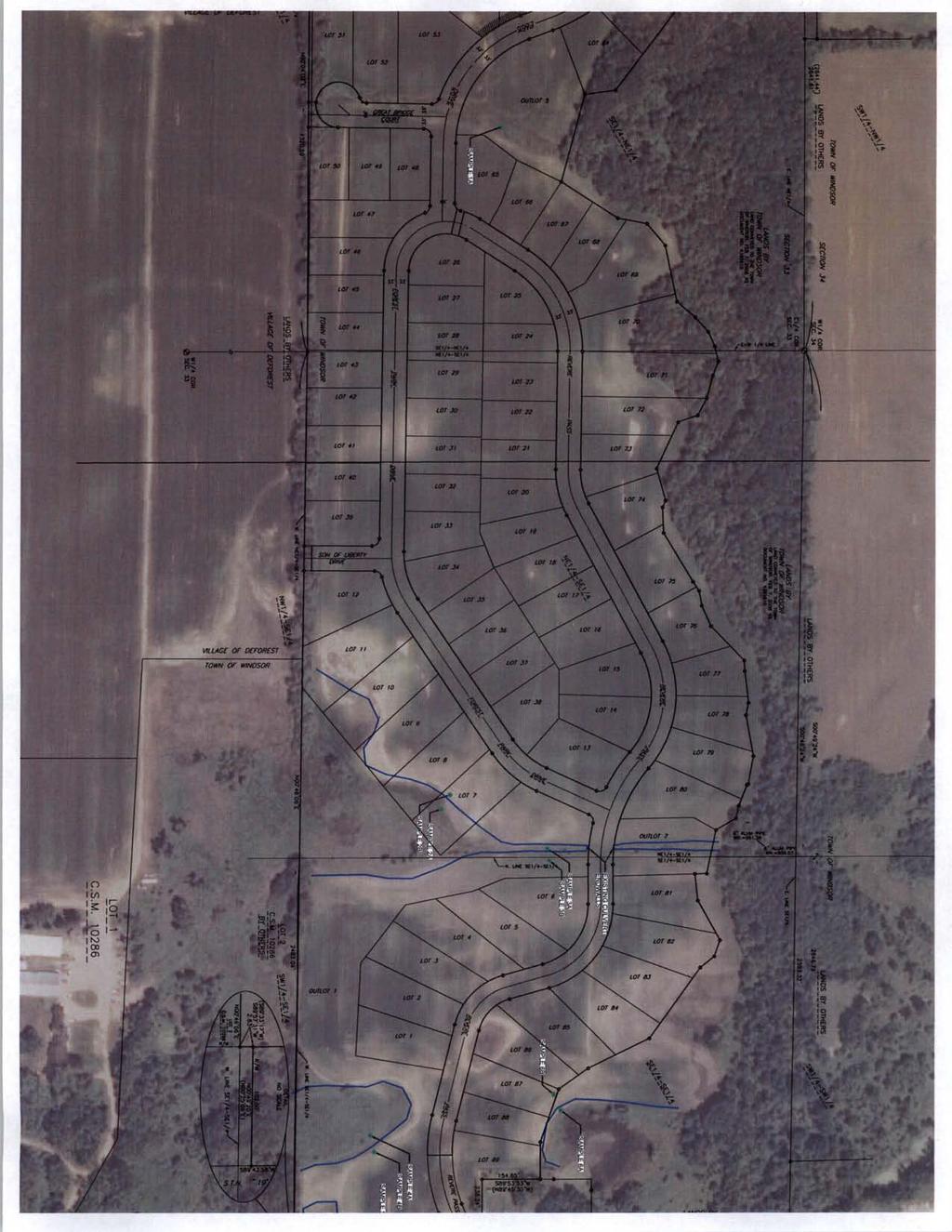
7 Dane County Planning & Development Land Division Review Date: July 17, 2012 To: Zoning & Land Regulation Committee From: Daniel Everson, Land Division Review Re: Revere Trails (preliminary plat) Town of Windsor, Section 33 & 34 (52 residential lots and 7 outlots, 73 acres) Review deadline August 19, 2012 Staff recommends the following conditions that will be applicable in approving the preliminary plat. Zoning 1. City of Sun Prairie Extraterritorial Zoning. Evidence of required zoning is to be established (publication in the official newspaper). Said publication is to include specific legal description. Dane County Comprehensive Plan 2. Compliance with the Dane County Comprehensive Plan is to be established. See Pam Andros, Senior Planner letter dated June 7, Before a subdivision plat may be recorded and filed for the same property, the condominium shall first be removed from the provisions of this chapter by recording a removal instrument. Currently, a recorded condominium, recorded as Document# , Dane County Registry. Platting of this land would violate S (1m)(b), Wisconsin Statutes. Dedication of Lands for public recreation within residential plats 4. The public park land appropriation requirement is to be satisfied (private park land does not satisfy this requirement). 5. All public land dedications are to be clearly designated dedicated to the public. 210 Martin Luther King Jr. Blvd. City-County Bldg, Room 116 Madison, WI Phone: Fax:
8 Land Suitability 6. Lots 24 thru 36 fall within the shoreland zone. (Lands, which are within 300 from the OHWM of the unnamed perennial stream. Shoreland erosion control permits will be required from Land Conservation. 7. A notation is to be included that states: Lands covered by this plat are within an area subject to height limitations owing to the operation of aircraft and equipment from a nearby airport. Owners of lands within the area covered by this plat are required by law to restrict the height of trees, other vegetation and man-made structures to less than the height limitations set forth in that certain map dated April 24, 2008, entitled Height Limitation Zoning Map, Dane County Regional Truax Field, Madison, Wisconsin, said map being on file in the Dane County Clerk's office. 8. A notation is to be included that states: Lands covered by this plat are located within an area subject to heightened noise levels emanating from the operation of aircraft and equipment from a nearby airport. Design Standards 9. Staff discussed making all lots conform to the Shoreland requirement of 100-foot frontage without the need of special setbacks. Lot 31 just falls below a 100 of lot width at the building setback. 10. Staff expressed concerns regarding the size of the lots at a meeting with the developer on April 16, The developer's agent had expressed the willingness to increase the size to approximately 30,000 square feet. Lots 1, 2, 6 to 10, 20 to 23, 26, 29, 33 to 36, 42 to 46, 48, 49, 51 and 52 are less than that number. 11. Outlot 6 does not meet the lot area requirements with respect to the shoreland-zoning district. Unsewered lots shall be not less than 100 feet in width at the building setback line and have an area of not less than 20,000 square feet. Land Division variance or redesign the outlot. 12. Rezone petition #10449 to rezone 0.02 acres of wetlands to non-wetland district shall be approved. Previous rezone petition #10315 was denied by the County Board on September 1, A strip of wetlands less than 5 acres was previously delineated shown intersecting through the proposed Revere Pass highway right-of-way. Since then, 2-concrete culvert pipes were installed for the purpose of an agricultural crossing. This area would have to be rezoned out of the shoreland- wetland district and permits from DNR and Army Corps of Engineers. 13. Lots 1, 2 and 3 will have a reduced building envelope due to the setbacks from the wetland and the public highway right-of-way. Staff recommends showing a building envelope on the plat. 210 Martin Luther King Jr. Blvd. City-County Bldg, Room 116 Madison, WI Phone: Fax:
9 14. Lots 25, 26 and 27 will have a reduced building envelope due to the setbacks from the OHWM of the perennial stream and the public highway right-of-way. Staff recommends showing a building envelope on the plat. 15. Outlot 4 does not meet the public road frontage requirements with respect to Ch (6)(b) and does not meet the lot area requirements with respect to the shoreland-zoning district. OL 4 is to be conveyed to the Town of Windsor prior to final plat approval/recording. 16. It was the general consensus in the April 16th meeting that the east-west stormwater corridor located in the center of the subdivision should be an outlot rather than shown as an easement. 17. Per DCO 75.19(h), Adjacent to OL 3, a minimum tangent length of 100 feet shall be used between reverse curves along FOREST PARK DRIVE and REVERE PASS. 18. A permanent or temporary cul-de-sac will be required at the west end of GREAT BRIDGE COURT and SON OF LIBERTY DRIVE, per DCO 75.19(q). 19. Street names with respect to Ch. 76 of the Dane County Code of Ordinances are to be assigned. Dane County Surveyor approval is to be obtained. 20. Utility easements are to be provided. 21. Village of DeForest corporate boundary lines are to be shown on the plat. Required Improvements 22. Grading and surfacing. All streets shall be graded and surfaced in accordance with plans, specifications and requirements of the Dane County Highway Commission and the Town of Windsor. 23. Compliance with Ch DCCO, Erosion Control Plans is to be established. 24. Compliance with Ch DCCO, Stormwater Control Permits is to be established. 25. Street lights and street signs shall be provided in accordance with applicable town specifications. 26. The improvements shall be installed and approval of a final plat shall be given only after the work has been completed or there shall have been filed with the appropriate governmental jurisdiction or with the committee, one of the following: Surety bond in an amount sufficient to complete the work. Certified check in an amount sufficient to complete the work. 210 Martin Luther King Jr. Blvd. City-County Bldg, Room 116 Madison, WI Phone: Fax:
10 Additional conditions 27. Town of Windsor approval is to be obtained. 28. Village of DeForest approval is to be obtained (extraterritorial jurisdiction). 29. State Highway 19 access approval shall be obtained and any comments or conditions from WisDOT are to be fulfilled. 210 Martin Luther King Jr. Blvd. City-County Bldg, Room 116 Madison, WI Phone: Fax:
266-4270, Rm. 362 Planning (608)266-4251, Rm. 116 Records & Support (608)266-4251, Rm.")


11 MEMORANDUM TO: FROM: Room 116, City-County Building, Madison, Wisconsin Fax (608) Zoning & Land Regulations (ZLR) Committee Pamela Andros, AICP, Senior Planner Housing & Economic Development (608) , Rm. 362 Planning (608) , Rm. 116 Records & Support (608) , Rm. 116 SUBJECT: Analysis of Revere Trails Preliminary Plat as it relates to Chapter 82 Subchapter II Dane County Comprehensive Planning, Town of Windsor, S33&34 Zoning (608) , Rm. 116 DATE: 06/7/2012 CC: Dan Everson, AZA & Plat Review Officer Roger Lane, Zoning Administrator Todd Violante, Director of Planning & Development Pam Dunphy, Public Works, Highways & Transportation Tina Butteris, Town of Windsor Clerk/Treasurer MHG Properties, LLC, Applicant As requested by the ZLR, staff provides analysis of subdivision plats comparing them against the local and county comprehensive plans. In this case, the analysis is of the consistency between the Revere Trails plat located in the Town of Windsor and the goals, objectives and policies of the Dane County Comprehensive Plan. The Dane County Comprehensive Plan describes broad policy directions for new development, but refers to component town and municipal plans for detailed land use, subdivision and public infrastructure recommendations relevant at the subdivision plat scale. This memo provides an update to the one provided last June. At that time the Revere Trails plat was a 62 (previously 83) residential lot subdivision with lots ranging from 20,000 to 30,000 square feet in size. Now the number of residential lots has been reduced to 54, and the range of lot sizes is now 25,000 to 40,000 square feet. During most recent meeting between the applicant, town and county staff, the county requested a minimum lot size of 30,000 square feet. The county-adopted Town of Windsor Comprehensive Plan: 2025 identifies the subject property in the Transition Residential land use district. The plan describes that future uses for this district include traditional single-family, detached neighborhoods including parks, schools and churches and on a limited basis, small-scale multi-family residential. The minimum lot size for this district is 12,000 square feet unless standards for Planned Residential Development (as outlined in the town subdivision code) are followed. It is also identified as being in Area 4 which is specified as Revere Trails. As part of the cooperative planning process with the Village of DeForest, the village agreed to amend their Future Land Use and Phasing Plans to coincide Dane County P&D, Revere Trails plat Page 1
12 with Town plans. The subject property is also shown, with general plat layout, in the Mixed Residential zoning district on the Sun Prairie-Windsor Joint Extraterritorial Zoning Map. The proposal is generally consistent with the component municipal plans, which both show the subject property in residential land use districts, but it should be noted that land suitability comes into play in all plans as they also contain natural resource protection elements. In addition to the analysis of component plans, other notable elements of the Dane County Comprehensive Plan include the Agricultural, Natural and Cultural Resources element (Chapter 5); the Land Use element (Chapter 8); and the Intergovernmental Cooperation element (Chapter 7). Under Water Resources, the comprehensive plan makes it clear that the county must continue to abide by the Dane County Water Quality Plan. The subject property is in close proximity to a wetland area associated with Pederson Spring that feeds into Token Creek. This tributary has been identified by the DNR as a spawning ground for brown trout. Protection of this resource is critical to achieve the wildlife resource goals of the Dane County Comprehensive plan. The applicant has removed all residential lots south of the strip of wetlands where hydric soils and wetlands are located. This is an improvement for addressing the above concerns. Another issue from previous submittals relates to nitrate levels. At that time, the applicant was asked to adequately demonstrate that proposed densities will not create nitrate groundwater pollution problems. Such information should show a comparison of nitrates associated with the current use to that of the proposed residential use. A key to this will be sanitary facilities and whether or not they will be adequate for the proposed configuration of lots. This concern goes back to the original proposal of over 80 lots, including lots located on land south of the strip of wetlands where hydric soils and wetlands are located. Removing those lots as well as decreasing the overall number of lots, thus decreasing overall density, alleviates concerns about nitrates to some degree. Regarding septic systems, the Public Health department states that the distribution component must be 50 from the ordinary high water mark. Everything else (tanks and pipes) can come within 10. The Dane County Comprehensive Plan uses Urban Service Areas (USA) as identified Smart Growth Areas. It should be noted that there is a recent Urban Service Area extension [Bear Tree] approved by DNR on 4/1/2011, located directly west of this property in the Village of DeForest. In order to meet intergovernmental cooperation goals, issues related to this proposal must be worked out between the town of Windsor and the Village of DeForest. Given the various joint planning efforts and agreements, it appears that intergovernmental issues are being addressed. I hope this information is helpful, and would be happy to answer any questions you may have. Please feel free to contact me at andros@countyofdane.com or if I can be of any further assistance. Dane County P&D, Revere Trails plat Page 2 of 2
13

14
15
16 DEFOREST AREA SCHOOL DISTRICT Revere Trails Town of Windsor, Section 33&34 Hydric Soils PC FARM HOLDINGS II LLC WINDSOR, TOWN OF STEVEN D PEDERSON LUKE A TITEL & ROBYN L TITEL st PEARL E KVALHEIM STEVEN D PEDERSON WINDSOR, TOWN OF DANE COUNTY WINDSOR, TOWN OF WILLIAM GRAFF Legend Hydric Inclusions All Hydric Æ 19 $
17
18
19
20
21
22
23
24
25
26 Town of Vermont Bergum Rd Destroyed Dwelling Town of Blue Mounds Feet Legend Wetlands > 2 acres 100-year floodplain Slopes > 12% Significant Soils Class Class 1 Petition Larson/Dillis Class 2
27 Dane County Zoning Division Recent Zoning Violations Vobren Trust (John Brereton); 7885 Brereton Road; Roxbury/Dane; junk/salvage yard; pending. Laura Wierzbicki (Greg Griswald); 3488 CTH J; Cross Plains; illegal use/junk; pending. KJK Enterprises LLP; 3738 County Highway P; Cross Plains; illegal use of existing building; pending. Allen Griffiths; 6127 Old Settlers Rd.; Berry; junk; pending. Michael Laufenberg; 3137 State Highway 78; Black Earth; junk; pending. Richard Bertrang Sr., (James); 9967 County Highway Y; storage of junk in front yard/outdoor sales; Mazomanie; pending. Guevara; 955 Burr Oak Ln; Madison; Keeping of livestock in R-3 district; Resolved; owner no longer keeps livestock Kippley; 3503 Whytecliff Way; Burke; Building a deck without a permit; Resolved, owner obtained permit Jones; 5935 Lien Rd; Burke; Illegal storage of junk vehicles; Resolved; owner removed unlicensed/inoperable vehicles Heil; 316 Powers Ave; Blooming Grove; Illegal Kennel Operation; Resolved; kennel no longer being run out of single family residence Brown; 5644 Lovick Rd; Vienna; Illegal auto repair in Ag district; Pending; Owner plans to submit a rezone application Zitlow; 4820 Windsor Prairie Rd; Vienna; Illegal storage of junk vehicles; Resolved; vehicles are now licensed Olejnik; 5420 Broken Bow Rd; Burke; Building without permit; Resolved; owner obtained permit Gehrke; 3449 CTH BB; Blooming Grove; Illegal storage of Junk; No violation found Leggett; 602 Powers Ave; Blooming Grove; Illegal outside storage; Resolved; on going yard sale ended and materials were moved in an enclosed building Wagner; 7166 CTH K; Springfield; Illegal storage of trash; Resolved; owner was informed of county ordinance and refuse was removed from the property McKenzie; 5372 Norse Ct; Burke; Illegal use of property; No violation found Nooyen;7622 USH 51; Windsor; Property not in compliance with town agreement Pending; Town will take action to rezone property Ray A. Peterson, 1128 Berlin Road, Medina, Outdoor storage of junk and junk items in C-1, Commercial District, referred to Corporation Counsel, 2/27/12, for injunctive relief. Violations found with inspection on 6/29/12. Andrew Johnson, 2272 US Highway 12 & 18, Cottage Grove, Commercial use in Rural Homes District and outdoor storage of junk and unlicensed vehicles, written complaint received 7/2/12 and 1/20/12. Gene Arndt, 1801 County Highway BB, Cottage Grove, Sales of new and used motor vehicles in A-1 Exclusive Agriculture District, major and minor repairs to motor vehicles, compliance deadline 7/15/12. Melvin Gratz, Jr., 6723 Prairie View Drive, Bristol, Outdoor storage of junk and junk items, compliance deadline, 7/25/12.
28 Kyle Vyse, 7613 County Highway N, Bristol, Major and minor repairs to motor vehicles in B-1, Business, compliance deadline 7/25/12. Jeffrey Kappel, 4685 Kennedy Road, Cottage Grove, Additions to existing storage shed without zoning permits, compliance deadline 7/25/12. Allen Seltzner, 7365 County Highway N, Bristol, Outdoor storage of junk and junk items in C-2 Commercial and A-B Agribusiness Districts, anonymous phone call to Town Clerk, awaiting written complaint, 6/6/12. Todd Flinkler, 1897 County Highway V, Bristol, Outdoor storage of junk and junk items, compliance deadline 7/16/12. Karen Weishan, 1525 Traut Road, Medina, 12 horses and boarding stable on RH-1, Rural Homes District, compliance deadline 7/16/12. Arlin Maag, 2095 County Highway BB, Cottage Grove, Addition to residence no zoning permit, compliance deadline 7/4/12. Rick Farnsworth, 3007 Midnight Sun Drive, Bristol, Location survey not submitted for new, single-family residence, compliance deadline, 7/2/12. Daniel Goff, 3023 County Highway BB, Cottage Grove, Residential use in C-2, Commercial District, awaiting Village of Cottage Grove Police report, compliance deadline 7/3/12. Charles Bronkhorst, 398 Sun Prairie Road, York, Limited family business in Rural Homes District, petition #10448, awaiting public hearing, 7/31/12. Ronald Reichers, 7033 Elder Lane, Bristol, Deed restriction violation, rock band practice in storage shed, reported by Dane County Sheriff, 2/5/12, band moved out 5/8/12. Jerry Ewers, 2883 Siggelkow Road, Cottage Grove, Lighting and trespass complaints, 1/19/12. Nathaniel Snyder, 2944 Hope Road, Cottage Grove, Structural alteration without zoning permit, filling and grading without shoreland erosion control permit, 5/21/12. Steven Pfeffer, 4545 Baxter Road, Cottage Grove, Rooster crowing in R-1, Residence District, closed 6/14/12. Eric Thomsen, 2226 Appaloosa Lane, Cottage Grove, Outdoor storage of junk items, awaiting written complaint, 7/5/12. Darrin Bachim, 5326 Betlach Road, Sun Prairie, Outdoor storage of junk items, items removed 3/26/12. Hackl Fields LLC, 2833 Larue Fields Lane, Sun Prairie, Lighting trespass, closed 3/5/12. Scott Freitag, 2989 Burke Road, Sun Prairie, Construction greater than 10% lot coverage, variance appeal granted 4/26/12, await zoning permit, deadline, 4/26/13. Craig Ball, 2362 Uphoff Road, Cottage Grove, Residential use in storage shed, closed 1/27/12. Anderson, 365 County Highway N, Dunkirk, junk in yard, pending. Buss, 1912 Barber Drive, Dunn, prohibited use of a boathouse, pending. Dintelman, 2417 County Highway AB, Dunn, Housing of chickens in a R-3 district, pending. Ewers, 4023 Tower Drive, Dunn, Junk, pending. Haugen, 3363 Petersen Road, Dunn, Storage of an RV in a cul-de-sac, pending.
29 Hutchins, 3993 Schneider Drive, Dunn, temporary sign, pending. Bert Davis, 2671 Circle Drive, Pleasant Springs, illegal use, pending. Warren, 2008 Spring Road, Pleasant Springs, Junk, pending. Boe, 2043 Skyline Drive, Pleasant Springs, illegal use of boathouse, pending. Andrew Graves; County Highway ID; Blue Mounds; New construction without prior approval; Pending (Referred to Corp. Counsel) Ryan Oelhof; 365 Tyvand Road; Perry; Illegal use of property, Motocross track built; Pending (Appeal denied by BOA) Maple Leaf Landscaping; 2416 Spring Rose Road; Verona; Illegal use of property. Landscaping business; Corrected (Citation was issued) equipment and vehicles was being parked on adjacent land that was zoned agricultural. Gail and Lawrence Rose; County Highway D; Oregon; Outdoor storage of inoperable vehicles; Corrected
Dane County Planning & Development Land Division Review
 Dane County Planning & Development Land Division Review Date: June 26, 2012 To: Zoning & Land Regulation Committee From: Daniel Everson, Land Division Review Re: Revere Trails (preliminary plat) Town of
ZONING & LAND REGULATION COMMITTEE Dane County Board of Supervisors MINUTES OF THE JANUARY 27, 2009 PUBLIC HEARING
 ZLR Committee Public Hearing Agenda Page 1 of 7 ZONING & LAND REGULATION COMMITTEE Dane County Board of Supervisors MINUTES OF THE JANUARY 27, 2009 PUBLIC HEARING MEMBERS PRESENT: Hendrick, Jensen, Miles,
ZONING & LAND REGULATION COMMITTEE Dane County Board Of Supervisors MINUTES OF THE MAY 9, 2006 WORK MEETING
 ZLR Committee Work Meeting Agenda Page 1 of 7 NOTE: These minutes reflect the notes of the recorder and are subject to correction and approval at a subsequent meeting of the Committee. ZONING & LAND REGULATION
Report to the Plan Commission December 19, 2011
 Report to the Plan Commission Legistar I.D. #24825, Extraterritorial Certified Survey Map Requested Action: Consideration of a two-lot Certified Survey Map (CSM) of the Keryluk-Wee property located at,,
Dane County Land Use Handbook
 Dane County Land Use Handbook Dane County Board of Supervisors Prepared by The Office of the County Board Last revision 4/6/98 Summary September 15, 1997 Dane County has land area of 1,202 square miles,
NOTE: These minutes reflect the notes of the recorder and are subject to correction and approval at a subsequent meeting of the Committee.
 July 27, 2006 Dane County Board of Adjustment Minutes Page 1 of 8 NOTE: These minutes reflect the notes of the recorder and are subject to correction and approval at a subsequent meeting of the Committee.
ZONING & LAND REGULATION COMMITTEE Dane County Board Of Supervisors MINUTES OF THE MAY 22, 2007 PUBLIC HEARING
 ZLR Committee Public Hearing Minutes Page 1 of 5 NOTE: These minutes reflect the notes of the recorder and are subject to correction and approval at a subsequent meeting of the Committee. ZONING & LAND
ARTICLE 3 DEFINITIONS
 Sections: 3-1 Rules of Construction 3-2 Definitions ARTICLE 3 DEFINITIONS SECTION 3-1 RULES OF CONSTRUCTION 3-101. a. The language set forth in these regulations shall be interpreted in accordance with
Staff Report: Date: Applicant: Property Identification: Acreage of Request: Current Zoning of Requested Area: Requested Action: Attached:
 Staff Report: Completed by Jeff Palmer Director of Planning & Zoning Date: November 7, 2018 Applicant: Greg Smith, Oberer Land Developer agent for Ronald Montgomery ET AL Property Identification: Frontage
Agenda ZNR Committee Page 1 DANE COUNTY BOARD OF SUPERVISORS
 Agenda ZNR Committee Page 1 DANE COUNTY BOARD OF SUPERVISORS ZONING & NATURAL RESOURCES Agenda Committee Date: APRIL 17 2001 Time: 7:30 P.M. Location: ROOM 2D CCB PLEASE NOTE: Persons requiring an interpreter,
Staff Report: Date: Applicant: Property Identification: Acreage of Request: Current Zoning of Requested Area: Requested Action: Attached:
 Staff Report: Completed by Jeff Palmer Director of Planning & Zoning Date: November 7, 2018, Updated November 20, 2018 Applicant: Greg Smith, Oberer Land Developer agent for Ronald Montgomery ET AL Property
Public Hearing: November 26, 2013 Petition: CUP 2250 Zoning Amendment: Acres:3.78 Survey Req. No Reason: Agriculture Entertainment Wedding barn
 Staff Report Zoning and Land Regulation Committee Public Hearing: November 26, 2013 Petition: CUP 2250 Zoning Amendment: Town/sect: A-1EX Exclusive Agriculture Blue Mounds District to A-1EX Exclusive Section
ZONING & LAND REGULATION COMMITTEE WORK MEETING AGENDA
 ZLR Committee Work Meeting Agenda Page 1 of 3 August 14, 2012 DANE COUNTY BOARD OF SUPERVISORS ZONING & LAND REGULATION COMMITTEE WORK MEETING AGENDA Date: Tuesday, August 14, 2012 Time: 7:30 P.M. Location:
Town of Prairie du Sac Sauk County, WI. Land Division Ordinance 07-3
 Town of Prairie du Sac Sauk County, WI Land Division Ordinance 07-3 1.01 DISCLAIMER (1) Multiple Jurisdictions. All persons reviewing the provisions of this Ordinance should be aware that the Town of Prairie
** If your lot does not meet the requirements above, please read Sec below
 Sec. 13-1-60 Zoning District Dimensional Requirements. For the Zoning Dept To Issue a Land Use Permit The Following Dimensions are Required. Minimum Side and Rear Yards s Lakes Classification Minimum Class
610 LAND DIVISIONS AND PROPERTY LINE ADJUSTMENTS OUTSIDE A UGB
 ARTICLE VI: LAND DIVISIONS AND PROPERTY LINE ADJUSTMENTS VI-21 610 LAND DIVISIONS AND PROPERTY LINE ADJUSTMENTS OUTSIDE A UGB 610-1 Property Line Adjustments (Property Line Relocation) A property line
PLANNING COMMISSION REPORT Regular Agenda Public Hearing Item
 PC Staff Report 11/12/12 Item No. 2B- 1 PLANNING COMMISSION REPORT Regular Agenda Public Hearing Item ITEM NO. 2B: A TO GPI; 110 ACRES; E OF K-10 & N OF W 6 TH ST (MKM) : Consider a request to rezone approximately
Certified Survey Map (CSM) Submittal Updated: 6/29/18
 Submittal Updated: 6/29/18") Certified Survey Map (CSM) Submittal Updated: 6/29/18 Town of Middleton 7555 W. Old Sauk Road Verona, WI 53593-9700 Phone: 608-833-5887 Fax: 608-833-8996 info@town.middleton.wi.us The Town of Middleton
Certified Survey Map (CSM) Submittal Updated: 6/29/18 Town of Middleton 7555 W. Old Sauk Road Verona, WI 53593-9700 Phone: 608-833-5887 Fax: 608-833-8996 info@town.middleton.wi.us The Town of Middleton
SECTION 4: PRELIMINARY PLAT
 SECTION 4: PRELIMINARY PLAT After the completion of the sketch plan process, if submitted, the owner or developer shall file with the City an application for preliminary plat. The preliminary plat stage
LETTER OF APPLICATION
 Description of Proposed Land Division: LETTER OF APPLICATION The proposed land division would split a 1.94 acres rectangular lot into two lots. The general configuration would have one lot in front of
ZONING & LAND USE APPLICATION
 City of Maple Plain 5050 Independence St P.O. Box 97 Maple Plain, MN 55359 Office: (763) 479-0515 Fax: (763) 479-0519 ZONING & LAND USE APPLICATION APPLICANT INFORMATION Applicant Name Company, if applicable
A.3. ARTICLE 7 PLAN REQUIREMENTS FOR MINOR SUBDIVISION AND/OR LAND DEVELOPMENT
 700. 701.A.3. ARTICLE 7 PLAN REQUIREMENTS FOR MINOR SUBDIVISION AND/OR LAND DEVELOPMENT SECTION 700 PURPOSE The purpose of this Article is to set forth a streamlined set of Plan Requirements for minor
1105 SUBDIVISIONS, PARTITIONS, REPLATS, CONDOMINIUM PLATS, AND VACATIONS OF RECORDED PLATS
 1105 SUBDIVISIONS, PARTITIONS, REPLATS, CONDOMINIUM PLATS, AND VACATIONS OF RECORDED PLATS 1105.01 PURPOSE AND APPLICABILITY Section 1105 is adopted to provide standards, criteria, and procedures under
Comprehensive Plan 2030
 Introduction The purpose of this chapter of the Comprehensive Plan is to accurately describe, in words and images, the goals and visions for the future of Clearfield, as determined by the people who live
APPLICATION FOR SUBDIVISION APPROVAL OF A SKETCH PLAN with checklist
 Prior to filing any application for SUBDIVISION approval, the applicant shall request in writing that the zoning administrator schedule a pre-submission conference. APPLICATION TO THE PLANNING BOARD TOWN
Chapter 8 INTRODUCTION.2. STATE SUBDIVISION REGULATIONS 2 State Review (Objecting Authorities) Local Review (Approving Authorities) Basis for Approval
 Local Review (Approving Authorities) Basis for Approval") INTRODUCTION.2 STATE SUBDIVISION REGULATIONS 2 State Review (Objecting Authorities) Local Review (Approving Authorities) Basis for Approval LOCAL LAND DIVISION REGULATIONS 6 General Organization of a Subdivision
INTRODUCTION.2 STATE SUBDIVISION REGULATIONS 2 State Review (Objecting Authorities) Local Review (Approving Authorities) Basis for Approval LOCAL LAND DIVISION REGULATIONS 6 General Organization of a Subdivision
Department of Planning & Development Planning Unit
 Department of Planning & Development Planning Unit Website: www.cityofmadison.com Madison Municipal Building 215 Martin Luther King, Jr. Boulevard P.O. Box 2985 Madison, Wisconsin 53701-2985 TDD 608 266-4747
CONDITIONAL USE PERMIT (CUP)
") CONDITIONAL USE PERMIT (CUP) LAND DEVELOPMENT APPLICATION FORM DEPARTMENT OF PLANNING 300 East Main Street, Sun Prairie, WI 53590-2227 (608)825-1107 FAX (608)825-1194 Applications will not be processed
CONDITIONAL USE PERMIT (CUP) LAND DEVELOPMENT APPLICATION FORM DEPARTMENT OF PLANNING 300 East Main Street, Sun Prairie, WI 53590-2227 (608)825-1107 FAX (608)825-1194 Applications will not be processed
A favorable recommendation to the City Council is requested.
 To: Sycamore Plan Commission From: Brian Gregory, City Manager Date: November 9, 2017 Re: November 13, 2017 Plan Commission Meeting The Plan Commission has one action item and three workshop items. I.
ARTICLE 23 CONDOMINIUM STANDARDS
 ARTICLE 23 CONDOMINIUM STANDARDS Section 23.01 Intent. The intent of this Article is to provide regulatory standards for condominiums and site condominiums similar to those required for projects developed
O-I (Office-Institutional) and AG-1(Agricultural)
 and AG-1(Agricultural)") PROPERTY INFORMATION ADDRESS 3503 and 3505 Bethany Bend DISTRICT, LAND LOTS 2/1 973 and 974 OVERLAY DISTRICT State Route 9 PETITION NUMBERS EXISTING ZONING O-I (Office-Institutional) and AG-1(Agricultural)
PROPERTY INFORMATION ADDRESS 3503 and 3505 Bethany Bend DISTRICT, LAND LOTS 2/1 973 and 974 OVERLAY DISTRICT State Route 9 PETITION NUMBERS EXISTING ZONING O-I (Office-Institutional) and AG-1(Agricultural)
Impact Fee Use in Dane County
 UNIVERSITY OF WISCONSIN MADISON/ETENSION Impact Fee Use in Dane County By Lara K. Rosen and Brian W. Ohm URPL Working Paper 11-03 10/1/2011 This research was funded through the University of Wisconsin-Etension
WESTON COUNTY FINAL PLAT APPLICATION
 WESTON COUNTY FINAL PLAT APPLICATION Property Owner: Mailing Address of owner: Telephone Number(s) of owner: Property Owner: Mailing Address of owner: Telephone Number(s) of owner: (If subdivider/applicant
Minutes of the ZNR Committee Page 1 MINUTES OF THE MEETING OF THE DANE COUNTY ZONING AND NATURAL RESOURCES COMMITTEE HELD ON APRIL 22, 2003
 Minutes of the ZNR Committee Page 1 MINUTES OF THE MEETING OF THE DANE COUNTY ZONING AND NATURAL RESOURCES COMMITTEE HELD ON APRIL 22, 2003 PRESENT: Anderson, Hendrick, Hitzemann, Pertzborn, Richmond,
4. facilitate the construction of streets, utilities and public services in a more economical and efficient manner;
 PVPC MODEL BYLAW BY-RIGHT CLUSTER ZONING BYLAW Prepared by Pioneer Valley Planning Commission Revised: October 2001 1.00 Development 1.01 Development Allowed By Right Development in accordance with this
For Office Use Only. Permit No. Fee: $ $ per proposed lot (AN ADDITIONAL 10% CODE COMPLIANCE FEE WILL BE CHARGED)
") For Office Use Only Permit No. Fee: $1600 + $560.00 per proposed lot (AN ADDITIONAL 10% CODE COMPLIANCE FEE WILL BE CHARGED) LAND PARTITION FOREST (Conditional Use) Crook County Planning Department 300
For Office Use Only Permit No. Fee: $1600 + $560.00 per proposed lot (AN ADDITIONAL 10% CODE COMPLIANCE FEE WILL BE CHARGED) LAND PARTITION FOREST (Conditional Use) Crook County Planning Department 300
Section 7.22: Multifamily Assisted Housing in AA-30 Residential Zone (MAHZ) [Note: an additional line will be added to the Table in Article 3, 3.1.
 [Note: an additional line will be added to the Table in Article 3, 3.1.") Section 7.22: Multifamily Assisted Housing in AA-30 Residential Zone (MAHZ) [Note: an additional line will be added to the Table in Article 3, 3.1.1A] 7.22.1 Purpose The purpose of this Special Regulation
Section 7.22: Multifamily Assisted Housing in AA-30 Residential Zone (MAHZ) [Note: an additional line will be added to the Table in Article 3, 3.1.1A] 7.22.1 Purpose The purpose of this Special Regulation
Understanding the Conditional Use Process
 Understanding the Conditional Use Process The purpose of this document is to explain the process of applying for and obtaining a conditional use permit in the rural unincorporated towns of Dane County.
NOTICE OF STATE MANDATED FEE! Approx. = $900 per Acre to Rezone A-1 Land
 NOTICE OF STATE MANDATED FEE! Approx. = $900 per Acre to Rezone A-1 Land STATE OF WISCONSIN MANDATED FARMLAND PRESERVATION ZONE DISTRICT REZONE CONVERSION FEE Beginning January 1, 2010, the State of Wisconsin
TOWN OF ROME 1156 ALPINE DR. NEKOOSA, WI (715)
") TOWN OF ROME 1156 ALPINE DR. NEKOOSA, WI 54457 (715) 325-8012 For obtaining a Permit for SHEDS AND DECKS the following must be done before the Inspector can issue the permit: 1. County Zoning Permit -
TOWN OF ROME 1156 ALPINE DR. NEKOOSA, WI 54457 (715) 325-8012 For obtaining a Permit for SHEDS AND DECKS the following must be done before the Inspector can issue the permit: 1. County Zoning Permit -
Rezoning Staff Report St. Croix County Community Development Committee Gerald & Joan Mellgren Hearing Date: July 16, 2015
 Rezoning Staff Report St. Croix County Community Development Committee Gerald & Joan Mellgren Hearing Date: Property Owners: Gerald & Joan Mellgren Agent: William Mellgren Site Address: 97 230 th Street
Preliminary Subdivision Application (Minor) (Three (3) lots or less)
 (Three (3) lots or less)") Gunnison City Offices www.gunnisoncity.org 38 West Center Gunnison, Utah 84634 (435) 528 7969 Date of Application: Preliminary Subdivision Application (Minor) (Three (3) lots or less) APPLICANT INFORMATION
Gunnison City Offices www.gunnisoncity.org 38 West Center Gunnison, Utah 84634 (435) 528 7969 Date of Application: Preliminary Subdivision Application (Minor) (Three (3) lots or less) APPLICANT INFORMATION
PENINSULA TOWNSHIP LAND DIVISION ORDINANCE TOWNSHIP OF PENINSULA COUNTY OF GRAND TRAVERSE, STATE OF MICHIGAN ORDINANCE NO OF 2012
 PENINSULA TOWNSHIP LAND DIVISION ORDINANCE TOWNSHIP OF PENINSULA COUNTY OF GRAND TRAVERSE, STATE OF MICHIGAN ORDINANCE NO OF 2012 AN ORDINANCE TO REGULATE THE DIVISION OF EXISTING PARCELS OF LAND PURSUANT
SUBDIVISION, PLANNING APPROVAL, & REZONING STAFF REPORT Date: June 4, 2015
 SUBDIVISION, PLANNING APPROVAL, & REZONING STAFF REPORT Date: June 4, 2015 APPLICANT NAME SUBDIVISION NAME DEVELOPMENT NAME LOCATION Board of Water & Sewer Commissioners of the City of Mobile MAWSS MLK
Zoning and Subdivision Regulations. Rebecca Roberts Center for Land Use Education UW Stevens Point/Extension
 Zoning and Subdivision Regulations Rebecca Roberts Center for Land Use Education UW Stevens Point/Extension Land Use Tools Comprehensive Plan describes the future vision of the community and how to achieve
CHAPTER 18 SUBDIVISION AND PLATTING ORDINANCE OF THE TOWN OF OSCEOLA CODE OF ORDINANCES
 TOWN OF OSCEOLA POLK COUNTY WISCONSIN ORDINANCE # 18-03-03 CHAPTER 18 SUBDIVISION AND PLATTING ORDINANCE OF THE TOWN OF OSCEOLA CODE OF ORDINANCES 18.01 Purpose Adopted 3/08/99, Amended 5/12/03, 7/9/07,
TOWN OF NORTHWOOD, NEW HAMPSHIRE
 TOWN OF NORTHWOOD, NEW HAMPSHIRE OFFICE OF THE PLANNING BOARD 818 First New Hampshire Turnpike, Northwood NH 03261 (603)942-5586 Extension 205 Facsimile: (603)942-9107 Major Subdivision Application Form
ELK RAPIDS TOWNSHIP ANTRIM COUNTY, MICHIGAN ORDINANCE NO
 ELK RAPIDS TOWNSHIP ANTRIM COUNTY, MICHIGAN ORDINANCE NO. 3-2011 AN ORDINANCE TO REPLACE THE SUBDIVISION CONTROL ORDINANCE WITH A NEW SUBDIVISION DEVELOPMENT ORDINANCE, IN ACCORD WITH THE LAND DIVISION
DRAFT MINUTES OF THE MEETING OF THE DANE COUNTY ZONING AND LAND REGULATION COMMITTEE HELD ON MAY 25,2004
 ZLR Committee Public Hearing Minutes May 25,2004 Page 1 of6 NOTE:These minutes reflect the notes ofthe recorder and are subject to correction and approval at a subsequent meeting ofthe Committee. DRAFT
RE: 6. GILL/GREEN COMPREHENSIVE PLAN AMENDMENT, REZONING AND PRELIMINARY PLAT
 commission memo DATE: Thursday - August 9, 2018 TO: Marion Planning & Zoning Commission FROM: David N. Hockett, AICP Principal Planner RE: 6. GILL/GREEN COMPREHENSIVE PLAN AMENDMENT, REZONING AND PRELIMINARY
APPLICATION for MINOR SUBDIVISION REVIEW for CONCEPT and FINAL PLAT within COALVILLE CITY. Project Name: Project Address or Area: Name of Owner:
 APPLICATION for MINOR SUBDIVISION REVIEW for CONCEPT and FINAL PLAT within COALVILLE CITY For Office Use Only: Application #: Application Date: PC Approval Date: CC Approval Date: Community Development
Department of Planning & Community & Economic Development Planning Division
 Department of Planning & Community & Economic Development Planning Division Travis Schreiber Vierbicher Associates 999 Fourier Drive #201 Madison, WI 53717 Website: www.cityofmadison.com Madison Municipal
LAND DIVISION AND SUBDIVISION CODE. Town of Springdale Dane County, Wisconsin
 1 2 3 4 5 6 7 8 9 10 11 12 13 14 15 16 17 18 19 20 21 22 23 24 25 26 27 28 29 30 31 32 33 34 35 36 37 38 39 40 41 42 43 44 45 46 Town of Springdale Dane County, Wisconsin Chapter 3. SUBCHAPTER 1 INTRODUCTION
Conservation Design Development Amendment to Zoning Ordinance as adopted by Town Council December 8, 2010
 Conservation Design Development Amendment to Zoning Ordinance as adopted by Town Council December 8, 2010 Definitions Add: Cluster- A site planning technique that concentrates buildings in specific areas
THE COUNTY BOARD OF SUPERVISORS OF THE COUNTY OF DOUGLAS DOES ORDAIN AS FOLLOWS:
 8.1 SUBDIVISION CONTROL ORDINANCE THE COUNTY BOARD OF SUPERVISORS OF THE COUNTY OF DOUGLAS DOES ORDAIN AS FOLLOWS: SECTION I. GENERAL INTERPRETATION This ordinance shall not repeal, impair or modify private
BYRON TOWNSHIP ZONING APPLICATION
 BYRON TOWNSHIP ZONING APPLICATION Phone: (616) 878-9104 * Fax: (616) 878-3980 * Website: www.byrontownship.org This application will not be accepted if incomplete. APPLICATION FOR & REQUIRED COPIES Private
Instructions to the Applicant
 CONDITIONAL USE PERMIT APPLICATION Lake of the Woods County Land and Water Planning Office 206 8 th Avenue Southeast, Suite #290 Baudette MN 56623-2867 www.co.lake-of-the-woods.mn.us Phone: (218) 634-1945
KLAMATH COUNTY PLANNING DEPARTMENT Government Center 305 Main St., Klamath Falls, Oregon Phone Option #4 Fax
 KLAMATH COUNTY PLANNING DEPARTMENT Government Center 305 Main St., Klamath Falls, Oregon 97601 Phone 541-883-5121 Option #4 Fax 541-885-3644 Land Partition Application Submittal Requirements (Please include
Planning Department Oconee County, Georgia
 Planning Department Oconee County, Georgia STAFF REPORT REZONE CASE #: 6985 DATE: October 31, 2016 STAFF REPORT BY: Andrew C. Stern, Planner APPLICANT NAME: Williams & Associates, Land Planners PC PROPERTY
DAUPHIN CREEK ESTATES SUBDIVISION
 # 12 SUB-000076-2017 DAUPHIN CREEK ESTATES SUBDIVISION Engineering Comments: FINAL PLAT COMMENTS (should be addressed prior to submitting the FINAL PLAT for review and/or signature by the City Engineer):
Township of Collier 2418 Hilltop Road Presto, PA 15142
 Township of Collier 2418 Hilltop Road Presto, PA 15142 Fees: Major: 2 checks $600 + $50 per lot & $1700 Escrow) APPLICATION FOR SUBDIVISION major FINAL only Plans must be folded Rolled plans will not be
Hello Plat Review, I have a question.
 Hello Plat Review, I have a question. January 24, 2018 2018 Surveyors' Institute 1 When do I have to do a subdivision plat? January 24, 2018 2018 Surveyors' Institute 2 236.02 (12) Definitions. Requires
To: Stillwater Town Board Reference: Horst Variance Request Stillwater Township, Minnesota Copies To: Town Board Kathy Schmoekel, Town Clerk
 MEMORANDUM To: Stillwater Town Board Reference: Horst Variance Request Copies To: Town Board Kathy Schmoekel, Town Clerk From: Soren Mattick, Attorney Daniel and Karla Horst, Applicants Ann Pung-Terwedo,
LETTER OF APPLICATION
 Description of Proposed Land Division: LETTER OF APPLICATION The proposed land division would split a 1.94 acres rectangular lot into two lots. The general configuration would have one lot in front of
TOWN OF WELLS, MAINE PLANNING BOARD
 1 0 1 0 1 TOWN OF WELLS, MAINE PLANNING BOARD Meeting Minutes Monday, June,, :00 P.M. Littlefield Meeting Room, Town Hall Sanford Road CALL TO ORDER AND DETERMINATION OF QUORUM Chairman Chuck Millian called
MAJOR SUBDIVISION PRELIMINARY PLAT CHECKLIST
 TOWNSHIP OF EGG HARBOR PLANNING BOARD/ZONING BOARD OF ADJUSTMENT 3515 BARGAINTOWN ROAD EGG HARBOR TOWNSHIP, NJ 08234 MAJOR SUBDIVISION PRELIMINARY PLAT CHECKLIST The following checklist is designed to
Deb Grube Walworth County Land Use and Resource Management
 Deb Grube dgrube@co.walworth.wi.us 262-741-7907 Walworth County Land Use and Resource Management www.co.walworth.wi.us County Zoning Contacts: Deb Grube (262) 741-7907 Board of Adjustment, Mobile Towers
TABLE OF CONTENTS CHAPTER 1 INTRODUCTORY PROVISIONS Section 1 Purposes. 6. Section 2 Statutory Authorization. 7.
 An Ordinance requiring permits for buildings, structures and the uses thereof; for land uses and for water supply and sewage treatment facilities; establishing minimum lot sizes, setbacks and side yards,
Initial Subdivision Applications Shall Include the Following:
 Initial Subdivision Applications Shall Include the Following: 1) Subdivision Application Form: completely filled out (12 copies) 2) Plat: The Plat must adhere to the requirements set forth in the Town
The City Engineering Division has reviewed the subject development and has the following comments.
 DATE: April 11, 2007 TO: FROM: SUBJECT: Plan Commission Larry D. Nelson, P.E., City Engineer 5756 Portage Road Certified Survey Map The City Engineering Division has reviewed the subject development and
APPENDIX B. SUBMISSION REQUIREMENTS
 Master Major Site Minor Site Landscape Section B.1 Table of /Plat Requirements Proposed or approved name of development, project, subdivision, and/or phase. Location, including township, county, and state.
Room 116, City-County Building, Madison, Wisconsin Fax (608)
") Room 116, City-County Building, Madison, Wisconsin 53703 Fax (608) 267-1540 TO: FROM: County Board Supervisors County Executive Joe Parisi Town of Windsor Supervisors Town of Windsor Planning Commission
Room 116, City-County Building, Madison, Wisconsin 53703 Fax (608) 267-1540 TO: FROM: County Board Supervisors County Executive Joe Parisi Town of Windsor Supervisors Town of Windsor Planning Commission
DRAFT FOR PUBLIC HEARING (rev. March, 2016)
") Chapter 200. ZONING Article VI. Conservation/Cluster Subdivisions 200-45. Intent and Purpose These provisions are intended to: A. Guide the future growth and development of the community consistent with
Chapter 200. ZONING Article VI. Conservation/Cluster Subdivisions 200-45. Intent and Purpose These provisions are intended to: A. Guide the future growth and development of the community consistent with
Chapter 100 Planned Unit Development in Corvallis Urban Fringe
 100.100 Scope and Purpose. Chapter 100 Planned Unit Development in Corvallis Urban Fringe (1) All applications for land divisions in the Urban Residential (UR) and Flood Plain Agriculture (FPA) zones within
TDR RULES AND PROCEDURES TRANSFER OF DEVELOPMENT RIGHTS (TDR) PROGRAM
 PROGRAM") TDR RULES AND PROCEDURES TRANSFER OF DEVELOPMENT RIGHTS (TDR) PROGRAM TOWN OF SPRINGFIELD, DANE COUNTY, WISCONSIN RECOMMENDED BY TOWN PLAN COMMISSION: 7/12/10 TDR RULES AND PROCEDURES, PLAN COMM. RECOMMENDED
TDR RULES AND PROCEDURES TRANSFER OF DEVELOPMENT RIGHTS (TDR) PROGRAM TOWN OF SPRINGFIELD, DANE COUNTY, WISCONSIN RECOMMENDED BY TOWN PLAN COMMISSION: 7/12/10 TDR RULES AND PROCEDURES, PLAN COMM. RECOMMENDED
Chapter 405 SUBDIVISION OF LAND. [HISTORY: Adopted by the Town Board of the Town of Middle Inlet Amendments noted where applicable.
 Chapter 405 SUBDIVISION OF LAND [HISTORY: Adopted by the Town Board of the Town of Middle Inlet 6-9-2005. Amendments noted where applicable.] Citations See Ch. 14. Planning Commission See Ch. 106. Driveways
ZONING AMENDMENT, PLANNED UNIT DEVELOPMENT & SUBDIVISION STAFF REPORT Date: August 8, 2013
 ZONING AMENDMENT, PLANNED UNIT DEVELOPMENT & SUBDIVISION STAFF REPORT Date: August 8, 2013 NAME SUBDIVISION NAME PV-Magnolia, LLC Twelve Trees Subdivision LOCATION 2860, 2862 and 2866 Pleasant Valley Road
Preliminary Subdivision Application (Major) (Four (4) lots or more)
 (Four (4) lots or more)") Gunnison City Offices www.gunnisoncity.org 38 West Center Gunnison, Utah 84634 (435) 528 7969 Date of Application: Preliminary Subdivision Application (Major) (Four (4) lots or more) APPLICANT INFORMATION
Gunnison City Offices www.gunnisoncity.org 38 West Center Gunnison, Utah 84634 (435) 528 7969 Date of Application: Preliminary Subdivision Application (Major) (Four (4) lots or more) APPLICANT INFORMATION
ARTICLE 5 GENERAL REQUIREMENTS
 5.1 SUITABILITY OF THE LAND ARTICLE 5 GENERAL REQUIREMENTS 5.1.1 Land subject to flooding, improper drainage or erosion, and land deemed to be unsuitable for development due to steep slope, unsuitable
CHARLOTTE PLANNING COMMISSION FINDINGS OF FACT AND DECISION IN RE APPLICATION OF
 Background CHARLOTTE PLANNING COMMISSION FINDINGS OF FACT AND DECISION IN RE APPLICATION OF Henrietta Ober 2296 Greenbush Road and Stephen and Margaret Foster 1259 Lime Kiln Road Final Plan Review For
Page 75-1 rev
 75.01 75.05 TITLE 14 PLANNING AND DEVELOPMENT Chapter 75 Land Division and Subdivision Regulations Chapter 76 Naming Roads and Numbering Buildings Chapter 78 Special Regulation of Structures and Trees
Umatilla County Department of Land Use Planning
 Umatilla County Department of Land Use Planning 216 SE 4 th ST, Pendleton, OR 97801, (541) 278-6252 PROCESSING TYPE I & III APPLICATIONS Land Division, Type I - IV Supplemental Application & Information
To provide for the review of the final engineering plans, the subdivision improvement agreement, public dedications, and other legal agreements.
 ARTICLE 5 FINAL PLAT 501 Intent DOUGLAS COUNTY SUBDIVISION RESOLUTION To provide for the review of the final engineering plans, the subdivision improvement agreement, public dedications, and other legal
ARTICLE Encourage well planned, efficient development.
 ARTICLE 14.00 PD PLANNED SECTIONS: 14.01 Intent 14.02 Procedure 14.03 Initial Development Plan 14.04 Final Development Plan 14.05 Amendments 14.06 Planned Development Districts PD-1 Willow Run PD PD-2
CHAPTER 14: DRIVEWAYS, TOWN HIGHWAYS, AND PRIVATE ROADS
 CHAPTER 14: DRIVEWAYS, TOWN HIGHWAYS, AND PRIVATE ROADS TABLE OF CONTENTS CHAPTER 14: PRIVATE DRIVEWAYS, TOWN HIGHWAYS AND PRIVATE ROADS 14-1 14.0100 AUTHORITY... 14-1 14.0200 TITLE... 14-1 14.0300 REGULATION
MINUTE ORDER BONNER COUNTY COMMISSIONERS PUBLIC HEARING MINUTES AUGUST 6, 2015
 MINUTE ORDER BONNER COUNTY COMMISSIONERS PUBLIC HEARING MINUTES AUGUST 6, 2015 CALL TO ORDER: Chair Cary Kelly called the Bonner County Commissioners hearing to order at 1:00 p.m. in the 3rd floor meeting
Title 17. Subdivisions
 Title 17 Subdivisions Chapters: 17.05 Introductory Provisions 17.10 Ordinance Compliance 17.15 Preliminary Review 17.20 Subdivision Plat Approval Procedure 17.25 Information on Tentative Plat for Proposed
STAFF REPORT. Arthur and Kathleen Quiggle 4(b)
") STAFF REPORT Application: Requests related to the construction of a 28' x 41' dwelling and 6' wrap-around open deck to replace an existing 24' x 32' cabin and wrap-around open deck and the installation
STAFF REPORT Application: Requests related to the construction of a 28' x 41' dwelling and 6' wrap-around open deck to replace an existing 24' x 32' cabin and wrap-around open deck and the installation
LABEL PLEASE NOTE: ALL APPLICATIONS AND SITE PLANS MUST BE COMPLETED IN BLACK OR BLUE INK ONLY Intake by:
 STAFF USE ONLY Thurston County Resource Stewardship 2000 Lakeridge Dr. S.W. Olympia, WA 98502 (360)786-5490 / (360)754-2939 (Fax) TDD Line (360) 754-2933 Email: permit@co.thurston.wa.us Supplemental Application
ARTICLE 7. SPECIFIC USE STANDARDS
 ARTICLE 7. SPECIFIC USE STANDARDS Section 7.1 Applicability The following standards apply to specified uses in all zoning districts in which such uses are allowed. Section 7.2 Accessory Apartments (A)
A. Preserve natural resources as identified in the Comprehensive Plan.
 1370.08 Conservation Residential Overlay District. Subd. 1 Findings. The City finds that the lands and resources within the Conservation Residential Overlay District are a unique and valuable resource
Major Subdivision Application Packet. Revised June 2018
 Major Subdivision Application Packet Revised June 2018 Caroline County Department of Planning and Community Development 233 West Broaddus Avenue Bowling Green, VA 22427 www.co.caroline.va.us Phone: 804-633-4303
City of Prior Lake APPLICATION FOR COMBINED PRELIMINARY AND FINAL PLAT
 Case File No. Property Identification No. City of Prior Lake APPLICATION FOR COMBINED PRELIMINARY AND FINAL PLAT Requested Action Brief description of proposed project (Please describe the proposed amendment,
DANE COUNTY BOARD OF SUPERVISORS
 ZLR Committee Work Meeting Agenda Page 1 of 3 April 12, 2011 DANE COUNTY BOARD OF SUPERVISORS ZONING & LAND REGULATION COMMITTEE WORK MEETING AGENDA Date: Tuesday, April 12, 2011 Time: 7:30 P.M. Location:
Legal Description Part of the Western Half of the Eastern Half of the Northwest Quarter of Section 30, Le Ray Township
 Owner and Applicant s 20448 State Highway 83 Mankato, MN 56001 Request and Location Request for review and approval of a Conditional Use Permit to allow an Elder Care Residential Unit to be constructed
TO: Glynn County Mainland Planning Commission. Eric Lee Johnson, Planning Division Manager. PP2944 McKenzie Gardens. DATE: November 20, 2014
 MEMO COMMUNITY DEVELOPMENT DEPARTMENT Planning and Zoning Division 1725 Reynolds Street, Suite 200, Brunswick, GA 31520 Phone: 912-554-7428/Fax: 1-888-252-3726 TO: Glynn County Mainland Planning Commission
ARTICLE 6 PRELIMINARY PLAT
 ARTICLE 6 PRELIMINARY PLAT SECTION: 30-06-01: Preliminary Plat 30-06-02: Information Required for Preliminary Plat 30-06-03: Determination of Requirement for Environmental Review Documents 30-06-04: Additional
PLANNING & DEVELOPMENT SERVICES 1800 Continental Place Mount Vernon, WA Inspections Office Fax 360.
 PLANNING & DEVELOPMENT SERVICES 1800 Continental Place Mount Vernon, WA 98273 Inspections 360.416.1330 Office 360.416-1320 Fax 360.416-1340 Date Received: Administrative Setback Reduction Checklist Pursuant
UPPER MOUNT BETHEL TOWNSHIP NORTHAMPTON COUNTY, PENNSYLVANIA
 UPPER MOUNT BETHEL TOWNSHIP NORTHAMPTON COUNTY, PENNSYLVANIA JOINDER DEED / LOT CONSOLIDATION TOWNSHIP REVIEW PROCESS When accepting proposed Joinder Deeds / Lot Consolidations, review the Joinder Deed
TOWN OF CLAYTON. Town Plan Commission. Meeting Minutes. 7:00 P.M. 8:12 P.M. on Wednesday, July 10 th, 2013
 TOWN OF CLAYTON Approved 08/14/13 Town Plan Commission Meeting Minutes 7:00 P.M. 8:12 P.M. on Wednesday, July 10 th, 2013 Town Office Meeting Room, 8348 County Road T, Larsen, WI 54947 I. Call to Order: