LETTER OF APPLICATION
|
|
|
- Darlene Goodwin
- 5 years ago
- Views:
Transcription
1
2

3
4 Description of Proposed Land Division: LETTER OF APPLICATION The proposed land division would split a 1.94 acres rectangular lot into two lots. The general configuration would have one lot in front of the other with a strip of land connecting the rear lot to the Airport Road. Lot Use Statement: Both lots created would be for single family residential use. Proposed Zoning Changes: There are no proposed zoning changes. The land is currently zoned A-1. Concept Plan for Adjacent Land with Same Owner: There is no other adjoining land owned by the applicant. Record of Recent Land Divisions: South of Airport Road there was a subdivision plat recorded in There was a C.S.M. recorded in 2001 that adjoins the subject property to the north and east and is currently City and Town of Middleton park land. The subject property and the parcel to the west were created by a C.S.M. recorded in Street Plans and Profiles: 104A WEST MAIN STREET, WAUNAKEE, WI NOA T. PRIEVE and CHRIS W. ADAMS PHONE: WEB: WILLIAMSONSURVEYING.COM No changes to public streets or right of ways are proposed.
5 104A WEST MAIN STREET, WAUNAKEE, WI NOA T. PRIEVE and CHRIS W. ADAMS PHONE: WEB: WILLIAMSONSURVEYING.COM July 25, 2014 Request for Variance. Tom Goff would like to request a variance from the Town in order to create a 2 lot certified survey map from one existing parcel totaling 1.94 acres. The variances requested are 1) Lot size as neither of these lots meet the 60,00 square foot minimum in a transition area, 2) Lot 2 does not meet the 40,000 square foot minimum for a variance and 3) Tom does not own the required 40 acres needed to create a lot under 5 acres. Tom plans to develop the site and would like to maximize the usable space in a mostly developed area. He wishes to create 2 parcels which would be residential home sites. The proposed Lot 1 and 2 will be 1.17 acres and 0.77 acres. Per the Town s conditions set forth in Section these lots would meet all criteria for a variance and would be considered infill in an area that is almost fully subdivided. Tom Goff met with the Town s Plan Commission in May where the Commission agreed with the concept of dividing this lot into two. We believe this request fits well with the rest of the Town as even the smaller of these two lots is substantially larger than the minimum lot size required in a clustered subdivision plat and is adjacent to open space on two sides. While the area could have been divided more evenly between the two lots to provide the required 40,000 square feet to each lot, we believe the proposed layout works and looks better than what would have resulted had we strictly followed the requirements. - Public Safety:. We are proposing that these two lots be served by one joint driveway with vehicular access being limited to Lot 1. This would thereby not add any additional access points other than the one anticipated for the existing lot. In addition, the access point has been placed towards the West to separate from the driveway to the parking lot. The two new residential homes should not increase the flow of traffic in this area by much. The minimal amount of additional traffic therefore will not create any new traffic hazards. Public infrastructure: This parcel and the proposed parcel configuration would fit the current and proposed plans for this area. Adequacy of access to parcel: As previously stated, a joint driveway will provide access to all parcels. Adequacy of access to adjoining parcels: No access is necessary to adjoining parcels through this parcel. Potential future development of adjacent parcels: All lands adjacent to this property are already developed as residential lots or public park land, all through certified survey maps. Building setbacks: This proposed certified survey map will meet all Town, City and County building requirements. After meeting the building setbacks for these parcels, the remaining building envelopes are large enough for a variety of sizes and layout of homes.. Land use: The proposed two-lot certified survey map will continue with the current residential use and conforms to all approved plans. Aesthetics: The proposed certified survey map lots will be spaced similarly to the adjoining parcels.
6
7
8


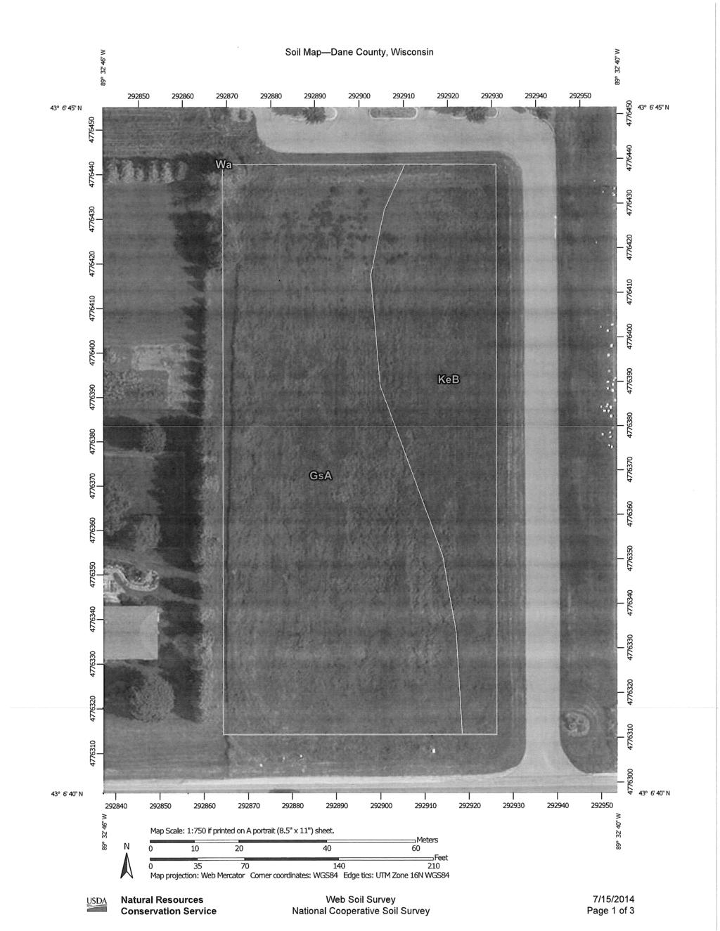
9 999 Fourier Drive, Suite 201 Madison, Wisconsin (608) phone (608) FAX July 25, 2014 Chairperson and Members of the Town Plan Commission Town of Middleton 7555 W. Old Sauk Road Verona, WI Re: Goff Certified Survey Map (CSM) Airport Road Town of Middleton Dear Ms. Schmidt and Plan Commission Members: The above-referenced CSM and other supporting documents were received in our office on July 21, 2014 and July 25, The CSM proposes creating two lots from one existing 84,600 square foot lot. The existing lot was created in 1981 as part of a 3 lot CSM. We have the following comments on the CSM: 1. Town Ordinances do not allow for the creation of lots by CSM below 5 acres unless the Applicant owns 40 acres adjacent to the proposed lots, in which case they can create two lots below 5 acres. Thus a variance for the proposed lots is required from this section of the ordinance. Ordinance Section (a)(3)D. outlines the requirements for granting a variance from this requirement. In addition, the proposed lots are Traditional Lots (no open space) which are required to have 65,000 square feet minimum. The proposed lots are 33,497 square feet and 51,103 square feet and thus require a second variance from this section of the ordinances. Ordinance Section (a)(3)B. outlines the requirements for granting a variance from minimum lot sizes in Traditional Subdivisions. The proposed lot sizes do not meet the conditions of items 3 and 7 of this section. And since the proposed Lot 1 is less than 85% of the lot area for the adjacent lot to the west, the lot to the west needs to agree to the proposed lot size. Requirement 3 of this section requires a maximum density for the land division to be one lot per 75,000 square feet (1 lot per 42,300 square feet is proposed). Item 7 requires that no lot is less than 40,000 square feet (proposed lot 1 has an area of 31,497 square feet). As required the Applicant has provided detail for their variance request. The Town has a Transition Zone adjacent to the City of Madison south of Old Sauk Road. Although no formal Transition Zone exists near the City of Middleton, a transition from large residential lots in the Town to a park in the City, with higher density, smaller lots as proposed, warrants consideration. The Town should determine if the variance proposed provides a reasonable approach for development of a lot that has remained vacant for a considerable time period. 2. The proposed CSM is in compliance with the Town Comprehensive Plan s future land use map, which designates the CSM area as future residential. vision to reality R e e d s b u r g ( ) M a d i s o n ( ) P r a i r i e d u C h i e n ( )
10 July 25, 2014 Page 2 3. The Town is aware of concerns for drainage onto and from the proposed CSM. The Applicant shall provide a topographic map that would demonstrate that drainage from homes built on the two proposed lots will be adequate for the new homes and that the drainage from the two homes will not adversely affect the neighboring lots. If the topographic survey does not demonstrate this by itself, proposed building and site grades may be necessary to make certain approval of these lots as building sites will not negatively affect neighboring properties with new drainage issues. 4. Given the reported poor drainage, minimum low openings for any structure built on the lots should be provided. Typically, the minimum elevation is 2 higher than the elevation of the runoff from a 100-year rainfall event. 5. The Town typically limits driveway access to Airport Road which is classified as a minor Arterial. A joint driveway should be considered for the two lots. If required by the Town, the joint driveway access location must be shown on the CSM. In addition, a joint driveway agreement outlining the rights and responsibilities of the lot owners shall be recorded. 6. A vision corner shall be placed on the CSM at any new driveway locations. Direct vehicular access to Airport Road from any other portion of the proposed lots shall be shown as restricted on the CSM. 7. Landscape easements and buffers are required on Major Land Divisions. A CSM is not a Major Subdivision per Town Ordinances, and thus the requirements do not apply. The Town may still want to request some sort of landscape buffer from the applicant. 8. The CSM lies with very close proximity of the Middleton Airport. As such, the following note shall be placed on the CSM: These lots lie within 1 mile of the Middleton Airport In addition it is recommended that the Applicant confirm Airport height restrictions will not impact structures placed on the proposed lots. 9. The existing street improvements on Airport Road shall be indicated on the CSM as required by Ordinance. This information will help determine if any additional right of way needs to be dedicated. 10. The existing utilities in the Airport Road right of way and the existing park driveway and parking lot shall be shown on the CSM. 11. The proposed front yard building setback for the proposed Lot 1 flag lot shall be shown on the CSM. 12. Section monuments are to be labeled with measured Wisconsin County Coordinates, and the map shall reference this system. 13. Underlying Lot 3 of CSM 3617 shall be labeled as the CSM. 14. Current zoning shall be noted on face of CSM. 15. The total right-of-way width of Airport Road should be noted on the CSM. 16. It is recommended that the note on sheet 3 regarding the building site information contained in the Dane County Soil Survey be placed on sheet 1 of the CSM. 17. The dimension from the Southwest corner of proposed Lot 1 to the section line should be noted on the CSM. 18. The final CSM shall be fully compliant with Chapter , Wis. Stats., Dane County Subdivision Ordinances, and Town of Middleton Subdivision Ordinances.
11 July 25, 2014 Page Due to the level of uncertainty with the proper dedication of Airport Road, this CSM should be revised to dedicate that part of Airport Road as previously referenced in CSM 3617 or show prior written evidence of the road dedication. 20. If the right-of-way dedication is required and if a mortgage exists on the property, a Consent of Mortgage Certificate shall be added. The owner s certificate shall also include a note acknowledging the dedication. 21. A title report was included in the CSM application. The Town Attorney shall confirm the adequacy of the information submitted. 22. The Title Commitment references a few easements in Schedule B Part 2 which will need to be placed on the CSM if they are applicable, specifically Document Numbers and This CSM lies within the City of Middleton extraterritorial zoning jurisdiction. The word Village shall be changed to City in the City s section of the signature page. 24. The following note shall be added to the CSM: Further Land Divisions by Certified Survey may be restricted for a period of up to five (5) years under the provisions of Section of the Town of Middleton Land Davison and Subdivision Ordinance. 25. Assuming parkland dedication is not required by the Town (Park Commission should confirm this), under Town ordinances, the payment of park fees ($2,255 per lot) in lieu of parkland dedication for the creation of one additional new lot is required. Park fees should be paid prior to the Town signing the CSM. 26. The prepared lot lies within the Airport Road impact fee area. The fee for the additional lot is $1,155 which shall be paid before the Town signs the CSM. Sincerely, Rod Zubella, PE President RZ/alh cc: Town of Middleton Board Town of Middleton Parks Commission David Shaw, Administrator, Town of Middleton Tom Voss, Town Attorney, Erbach & Voss, SC Tom Goff, 2412 Amherst Road, Middleton, WI Noa Prieve, PLS, Williamson Surveying and Associates, LLC Mike Ziehr, PLS, Vierbicher M:\Middleton, Town of\140005_2014 Engineering Review\Task 5 Goff Airport Road CSM\Plan Commission Ltr re Goff CSM.doc
12
13
14
15
16
17
LETTER OF APPLICATION
 Description of Proposed Land Division: LETTER OF APPLICATION The proposed land division would split a 1.94 acres rectangular lot into two lots. The general configuration would have one lot in front of
Certified Survey Map (CSM) Submittal Updated: 6/29/18
 Submittal Updated: 6/29/18") Certified Survey Map (CSM) Submittal Updated: 6/29/18 Town of Middleton 7555 W. Old Sauk Road Verona, WI 53593-9700 Phone: 608-833-5887 Fax: 608-833-8996 info@town.middleton.wi.us The Town of Middleton
Certified Survey Map (CSM) Submittal Updated: 6/29/18 Town of Middleton 7555 W. Old Sauk Road Verona, WI 53593-9700 Phone: 608-833-5887 Fax: 608-833-8996 info@town.middleton.wi.us The Town of Middleton
RE: File No. LD 1516 Certified Survey Map Tradewinds Parkway (B-R Enterprises of Madison, LLC)
") Department of Planning & Community & Economic Development Planning Division Katherine Cornwell, Director Madison Municipal Building, Suite LL-100 215 Martin Luther King, Jr. Boulevard P.O. Box 2985 Madison,
Department of Planning & Community & Economic Development Planning Division Katherine Cornwell, Director Madison Municipal Building, Suite LL-100 215 Martin Luther King, Jr. Boulevard P.O. Box 2985 Madison,
Cover Letter with Narrative Statement
 Cover Letter with Narrative Statement March 31, 2017 rev July 27, 2017 RE: Rushton Pointe Residential Planned Unit Development Application for Public Hearing for RPUD Rezone PL2015 000 0306 Mr. Eric Johnson,
3.1. OBJECTIVES FOR RESIDENTIAL LAND USE DESIGNATIONS GENERAL OBJECTIVES FOR ALL RESIDENTIAL DESIGNATIONS
 3. RESIDENTIAL LAND USE DESIGNATIONS INTRODUCTION The Residential land use designations provide for housing and other land uses that are integral to, and supportive of, a residential environment. Housing
Final Plats for Major Residential and Commercial Subdivisions Checklist
 Project Name: : This form is a checklist of Zoning Ordinance requirements for major residential and commercial subdivision plats to assist the applicant in their submittal. It is not intended to be a comprehensive
Guide to Minor Developments
 Guide to Minor Developments Introduction The Douglas County (DCD) is committed to providing open, transparent application processes to the public. This Guide is provided to assist anyone interested in
PLANNING COMMISSION REPORT REGULAR AGENDA
 PP-4-4-11 Item No. 9-1 PLANNING COMMISSION REPORT REGULAR AGENDA PC Staff Report 06/22/11 ITEM NO 9: PRELIMINARY PLAT; KASOLD WATER TOWER ADDITION; SE OF TAM O SHANTER & KASOLD DR (MKM) PP-4-4-11: Consider
TOWN OF LERAY PLANNING BOARD Minor Subdivision Application Packet
 This Packet is designed to assist applicants in providing the forms needed for submission of a 1 to 4 lot subdivision to the Planning Board for approval. The following should be filled out to ensure the
I. Requirements for All Applications. C D W
 108-16.1. Application checklists. Checklist for Required Submissions to the Planning Board or Zoning Board of Adjustment of Monroe Township All required submissions are to be made to the Administrative
Group Sewer Only** 80 Ft Frontage* 20,000 Sq. Ft. (.46 acre) Minimum** 120 Ft Frontage* 20,000 Sq. Ft. (.46acre) Minimum** 150 Ft Frontage*
 Minimum** 120 Ft Frontage* 20,000 Sq. Ft. (.46acre) Minimum** 150 Ft Frontage*") Residential Lots Minimum Chart The minimum lot size of any minor subdivision where there is no public sewers shall be as shown below or as required by township zoning and/or the Tuscarawas General Health
Residential Lots Minimum Chart The minimum lot size of any minor subdivision where there is no public sewers shall be as shown below or as required by township zoning and/or the Tuscarawas General Health
FREQUENTLY USED PLANNING & ZONING TERMS
 City Of Mustang FREQUENTLY USED PLANNING & ZONING TERMS Abut: Having property lines, street lines, or zoning district lines in common. Accessory Structure: A structure of secondary importance or function
CITY OF NAPLES STAFF REPORT
 Meeting of 11/9/16 Subdivision/Replat Petition 16-SD3 CITY OF NAPLES STAFF REPORT To: Planning Advisory Board From: Planning Department Subject: Subdivison/Replat Petition 16-SD3 Petitioner: Matthew Grabinski,
Appendix J - Planned Unit Development (PUD)
") Appendix J - Planned Unit Development (PUD) Intent and Purpose The purpose of the PUD is: 1. To provide development that is consistent with the Comprehensive Land Use Plan and promote the goals and objectives
Appendix J - Planned Unit Development (PUD) Intent and Purpose The purpose of the PUD is: 1. To provide development that is consistent with the Comprehensive Land Use Plan and promote the goals and objectives
REPORT TO THE SHELBY COUNTY PLANNING COMMISSION From the Department of Development Services Planning Services. February 4, 2019
 REPORT TO THE SHELBY COUNTY PLANNING COMMISSION From the Department of Development Services Planning Services February 4, 2019 Case No. Request for Rezoning Approval From E-1 to E-2 SD This is a request
MS MINOR SUBDIVISION TREVITHICK
 MS-02-015 341.12 MINOR SUBDIVISION TREVITHICK A request by Danny Trevithick for a one-lot Minor Subdivision on five acres. The property is zoned A-35 (Agricultural) District and is located ¼ mile south
RP-2, RP-3, RP-4, AND RP-5 PLANNED RESIDENTIAL DISTRICTS
 6.10 - RP-2, RP-3, RP-4, AND RP-5 PLANNED RESIDENTIAL DISTRICTS 6.10.1 GENERAL DESCRIPTION: 6.10.1.1 The regulations established in this Section are intended to provide optional methods of land development
UPPER MOUNT BETHEL TOWNSHIP NORTHAMPTON COUNTY, PENNSYLVANIA
 UPPER MOUNT BETHEL TOWNSHIP NORTHAMPTON COUNTY, PENNSYLVANIA JOINDER DEED / LOT CONSOLIDATION TOWNSHIP REVIEW PROCESS When accepting proposed Joinder Deeds / Lot Consolidations, review the Joinder Deed
DRAFT FOR PUBLIC HEARING (rev. March, 2016)
") Chapter 200. ZONING Article VI. Conservation/Cluster Subdivisions 200-45. Intent and Purpose These provisions are intended to: A. Guide the future growth and development of the community consistent with
Chapter 200. ZONING Article VI. Conservation/Cluster Subdivisions 200-45. Intent and Purpose These provisions are intended to: A. Guide the future growth and development of the community consistent with
Guide to Preliminary Plans
 Guide to Preliminary Plans Introduction The Douglas County is committed to providing open, transparent application processes to the public. This Guide is provided to assist anyone interested in the procedures
PLANNED UNIT DEVELOPMENTS (Ordinance No.: 3036, 12/3/07; Repealed & Replaced by Ordinance No.: 4166, 10/15/12)
") 159.62 PLANNED UNIT DEVELOPMENTS (Ordinance No.: 3036, 12/3/07; Repealed & Replaced by Ordinance No.: 4166, 10/15/12) A. PURPOSE 1. General. The Planned Unit Development (PUD) approach provides the flexibility
159.62 PLANNED UNIT DEVELOPMENTS (Ordinance No.: 3036, 12/3/07; Repealed & Replaced by Ordinance No.: 4166, 10/15/12) A. PURPOSE 1. General. The Planned Unit Development (PUD) approach provides the flexibility
AN ORDINANCE AMENDING THE CITY ZONING ORDINANCE AND THE OFFICIAL CODE OF THE CITY OF CLARKSVILLE RELATIVE TO CLUSTER OPTION DEVELOPMENTS
 ORDINANCE 74-2012-13 AN ORDINANCE AMENDING THE CITY ZONING ORDINANCE AND THE OFFICIAL CODE OF THE CITY OF CLARKSVILLE RELATIVE TO CLUSTER OPTION DEVELOPMENTS BE IT ORDAINED BY THE CITY COUNCIL OF THE CITY
Plat Checklist PLAT TYPES AND DESCRIPTIONS
 Master Plan / Revision to Master Plan (For Platting Purposes Only) Preliminary/Final Plat Preliminary Plat Final Plat Minor Plat Replat Amended Plat Plat Checklist So that we may efficiently review your
MINOR LAND DIVISIONS APPLICATION
 APACHE COUNTY Planning and Zoning Department P.O. Box 238 St. Johns, AZ 85936 Phone: (928) 337-7527 Fax: (928) 337-7633 MINOR LAND DIVISIONS APPLICATION APPLICANT Name Mailing Address Contact Person Phone
Organized with a "core" curriculum (the first five modules) and "electives" (the remaining modules in the program.
 and electives (the remaining modules in the program.") Introduction Sponsored by The North Carolina Chapter - American Planning Association These materials are the result of an effort by volunteer members of the North Carolina Chapter of the American Planning
Introduction Sponsored by The North Carolina Chapter - American Planning Association These materials are the result of an effort by volunteer members of the North Carolina Chapter of the American Planning
Community Development Department 333 Broadalbin Street SW, P.O. Box 490 Albany, OR 97321
 SUMMARY Community Development Department 333 Broadalbin Street SW, P.O. Box 490 Albany, OR 97321 STAFF REPORT Application for Tentative Partition Plat Review Planning File PA-06-17 Phone: 541-917-7550
FINAL PLAN CHECKLIST
 FINAL PLAN CHECKLIST Subdivision Name: Subdivision Number: Project Number: REVIEW CRITERIA Plans: A final plan shall be on a 24 x 36 sheet at a scale that is no smaller than 1 = 40 and shall contain all
Department of Planning & Development Services
 Department of Planning & Development Services S T A F F R E P O R T February 9, 2015 CASE NO: PROJECT: EXECUTIVE SUMMARY: ZA14-154 Plat Revision for Lots 25R-1A, 25R-1B and 25R-1C, Block 1, Woodland Heights
ZONING AMENDMENT & SUBDIVISION STAFF REPORT Date: November 3, 2016
 ZONING AMENDMENT & SUBDIVISION STAFF REPORT Date: November 3, 2016 APPLICANT NAME SUBDIVISION NAME David Shumer 5955 Airport Subdivision CITY COUNCIL DISTRICT District 6 5955 Airport Boulevard, 754 Linlen
Staff Report: Date: Applicant: Property Identification: Acreage of Request: Current Zoning of Requested Area: Requested Action: Attached:
 Staff Report: Completed by Jeff Palmer Director of Planning & Zoning Date: November 7, 2018, Updated November 20, 2018 Applicant: Greg Smith, Oberer Land Developer agent for Ronald Montgomery ET AL Property
THE CITY OF MOBILE, ALABAMA
 THE CITY OF MOBILE, ALABAMA LETTER OF DECISION Dominion Senior Living of West Mobile, LLC 1200 Corporate Dr., St. 225 Birmingham, AL 35242 Re: 6924 Somerbv Lane (North terminus of Somerby Lane). Council
Planning Justification Report - Update Castlegrove Subdivision, Gananoque Draft Plan of Subdivision and Class III Development Permit
 Planning Justification Report - Update Castlegrove Subdivision, Gananoque Draft Plan of Subdivision and Class III Development Permit by IBI Group Table of Contents Executive Summary... 1 1 Introduction...
Department of Planning & Community & Economic Development Planning Division
 Department of Planning & Community & Economic Development Planning Division Travis Schreiber Vierbicher Associates 999 Fourier Drive #201 Madison, WI 53717 Website: www.cityofmadison.com Madison Municipal
STAFF REPORT FOR MAJOR SUBDIVISION
 STAFF REPORT FOR MAJOR SUBDIVISION FINAL PLAT CASE NO. FA-14-001 HEARING DATE: January 6, 2016 CASE NAME: Solterra Subdivision Filing No. 16 PROCEDURE: Planning Commission ADDRESS OF MAJOR SUBDIVISION
Development Variance Permit
 City of Surrey PLANNING & DEVELOPMENT REPORT 7906-0382-00 Development Variance Permit Proposal: Development Variance Permit to vary the minimum lot depth and the minimum front yard and rear yard setbacks
STAFF REPORT FOR MAJOR SUBDIVISION
 STAFF REPORT FOR MAJOR SUBDIVISION FINAL PLAT CASE NO. FA-13-001 HEARING DATE: November 6, 2013 CASE NAME: Solterra Subdivision Filing No. 14 PROCEDURE: Planning Commission ADDRESS OF MAJOR SUBDIVISION
Midwest City, Oklahoma Zoning Ordinance
 2010 Midwest City, Oklahoma Zoning Ordinance 9/2/2010 Table of Contents Section 1. General Provisions... 5 1.1. Citation... 5 1.2. Authority... 5 1.3. Purpose... 5 1.4. Nature and Application... 5 1.5.
CERTIFICATION OF THE APPROVAL OF WATER AND SEWERAGE SYSTEMS
 ARTICLE 9 FORMS AND CHECK LISTS 9.100 On preliminary layout & final subdivision plat CERTIFICATION OF THE APPROVAL OF WATER AND SEWERAGE SYSTEMS I hereby certify that the (...type: private or pubic...)
PLANNING COMMISSION REPORT Regular Agenda -Public Hearing Item
 PDP-13-00518 Item No. 3B- 1 PLANNING COMMISSION REPORT Regular Agenda -Public Hearing Item PC Staff Report 2/24/14 ITEM NO. 3B PRELIMINARY DEVELOPMENT PLAN FOR HERE @ KANSAS; 1101 INDIANA ST (SLD) PDP-13-00518:
Initial Subdivision Applications Shall Include the Following:
 Initial Subdivision Applications Shall Include the Following: 1) Subdivision Application Form: completely filled out (12 copies) 2) Plat: The Plat must adhere to the requirements set forth in the Town
BOARD OF ZONING APPEALS CASE SUMMARY FOR VARIANCE REQUEST. 325 Veterans Road
 BOARD OF ZONING APPEALS CASE SUMMARY FOR VARIANCE REQUEST 325 Veterans Road April 11, 2017 at 10:00 A.M. City Council Chambers, 1737 Main Street, 3 rd Floor Columbia, South Carolina Case Number: 2017-0031-V
Staff Report: Date: Applicant: Property Identification: Acreage of Request: Current Zoning of Requested Area: Requested Action: Attached:
 Staff Report: Completed by Jeff Palmer Director of Planning & Zoning Date: November 7, 2018 Applicant: Greg Smith, Oberer Land Developer agent for Ronald Montgomery ET AL Property Identification: Frontage
CHAPTER 45 SUBDIVISION ORDINANCE CHAPTER 45 LAND DIVISION AND SUBDIVISION REGULATIONS
 CHAPTER 45 LAND DIVISION AND SUBDIVISION REGULATIONS 45.01 TITLE 45.02 INTENT AND PURPOSE 45.03 GENERAL REQUIREMENTS (1) Conformance with Policies (2) Land Suitability (3) Determination of Adequacy of
DEVELOPMENT DEPARTMENT STAFF REPORT
 DEVELOPMENT DEPARTMENT STAFF REPORT Meeting Date: January 11, 2018 Item #: PZ2017-151 STAFF REPORT VARIANCES RESTAURANT WITH DRIVE-THROUGH Request: Multiple Variances for a new restaurant with drive-through
Plat Alteration request of Barkley North LLC re 3400 Sussex Drive (aka Village on the Green Division #5 Tract B) 08/26/2015
 08/26/2015") Hearing Examiner Summary and Decision Hearing Examiner No. Planning No. Incident No. Filing Date City Contact Hearing Date Description Decision Date Decision Summary HE-15-PL-022 SUB2015-00019 06/22/2015
Hearing Examiner Summary and Decision Hearing Examiner No. Planning No. Incident No. Filing Date City Contact Hearing Date Description Decision Date Decision Summary HE-15-PL-022 SUB2015-00019 06/22/2015
Town of Prairie du Sac Sauk County, WI. Land Division Ordinance 07-3
 Town of Prairie du Sac Sauk County, WI Land Division Ordinance 07-3 1.01 DISCLAIMER (1) Multiple Jurisdictions. All persons reviewing the provisions of this Ordinance should be aware that the Town of Prairie
STAFF REPORT FOR MAJOR SUBDIVISION
 STAFF REPORT FOR MAJOR SUBDIVISION FINAL PLAT CASE NO. FA-12-003 HEARING DATE: November 6, 2013 CASE NAME: Solterra Subdivision Filing No. 13 PROCEDURE: Planning Commission ADDRESS OF MAJOR SUBDIVISION
Condominium Unit Requirements.
 ARTICLE 19 CONDOMINIUM REGULATIONS Section 19.01 Purpose. The purpose of this Article is to regulate projects that divide real property under a contractual arrangement known as a condominium. New and conversion
ARTICLE 13 CONDOMINIUM REGULATIONS
 ARTICLE 13 CONDOMINIUM REGULATIONS Section 13.01 Purpose. The purpose of this Article is to regulate projects that divide real property under a contractual arrangement known as a condominium. New and conversion
City of Harrisburg Variance and Special Exception Application
 City of Harrisburg Variance and Special Exception Application Note: The Planning Bureau will review all applications for completeness; incomplete applications may cause a delay in processing. Contact Ben
MAJOR SUBDIVISION PRELIMINARY PLAT CHECKLIST
 TOWNSHIP OF EGG HARBOR PLANNING BOARD/ZONING BOARD OF ADJUSTMENT 3515 BARGAINTOWN ROAD EGG HARBOR TOWNSHIP, NJ 08234 MAJOR SUBDIVISION PRELIMINARY PLAT CHECKLIST The following checklist is designed to
CHAPTER 18 SUBDIVISION AND PLATTING ORDINANCE OF THE TOWN OF OSCEOLA CODE OF ORDINANCES
 TOWN OF OSCEOLA POLK COUNTY WISCONSIN ORDINANCE # 18-03-03 CHAPTER 18 SUBDIVISION AND PLATTING ORDINANCE OF THE TOWN OF OSCEOLA CODE OF ORDINANCES 18.01 Purpose Adopted 3/08/99, Amended 5/12/03, 7/9/07,
VARIANCE PROCEDURE The City Council will consider the request and either grant or deny the variance.
 VARIANCE PROCEDURE 1 The Minnetrista City Code was established to protect both current and future residents from the negative impacts of improper development and to ensure a positive future for the city.
DENTON Developer's Handbook
 DENTON Developer's Handbook A guide for land development in the City of Denton Department of Development Services 2017 2 Table of Contents 1. City of Denton Development Process...5 Role of the Development
ARTICLE 15 - PLANNED UNIT DEVELOPMENT
 Section 15.1 - Intent. ARTICLE 15 - PLANNED UNIT DEVELOPMENT A PUD, or Planned Unit Development, is not a District per se, but rather a set of standards that may be applied to a development type. The Planned
CHAPTER 3 PRELIMINARY PLAT
 10-3-1 10-3-3 SECTION: CHAPTER 3 PRELIMINARY PLAT 10-3-1: Consultation 10-3-2: Filing 10-3-3: Requirements 10-3-4: Approval 10-3-5: Time Limitation 10-3-6: Grading Limitation 10-3-1: CONSULTATION: Each
-MENDOCINO COUNTY PLANNING AND BUILDING SERVICES- DIVISION OF LAND REGULATIONS TITLE 17
 ARTICLE VI -- GENERAL REGULATIONS AND PROVISIONS Sec. 17-50. Sec. 17-51 General Plan. Sec. 17-52 Lot and Block Design and Configuration. Sec. 17-53 Lot Access. Sec. 17-54 Private Roads. Sec. 17-55 Water
CITY OF SARALAND PRELIMINARY SUBDIVISION PLAT REVIEW
 PRELIMINARY SUBDIVISION PLAT REVIEW Application Number: Date Plat Submitted: Name of Subdivision: Name of Owner: Owner Address: (Street or P.O. Box) Telephone #: (City) (State) (Zip) E-mail: Name of Authorized
(a) Commercial uses on Laurel Avenue, abutting the TRO District to the
 Commercial uses on Laurel Avenue, abutting the TRO District to the") 32X Zoning Code 150.36 TRANSITIONAL RESIDENTIAL OVERLAY DISTRICT. (A) Intent and purpose. (1) It is the intent of the Transitional Residential Overlay District (hereinafter referred to as the "TRO District")
32X Zoning Code 150.36 TRANSITIONAL RESIDENTIAL OVERLAY DISTRICT. (A) Intent and purpose. (1) It is the intent of the Transitional Residential Overlay District (hereinafter referred to as the "TRO District")
Chapter 100 Planned Unit Development in Corvallis Urban Fringe
 100.100 Scope and Purpose. Chapter 100 Planned Unit Development in Corvallis Urban Fringe (1) All applications for land divisions in the Urban Residential (UR) and Flood Plain Agriculture (FPA) zones within
SUBDIVISION REGULATIONS OF THE CITY OF DERBY, KANSAS
 SUBDIVISION REGULATIONS OF THE CITY OF DERBY, KANSAS ARTICLE 1. TITLE, PURPOSE, AUTHORITY, JURISDICTION, APPLICABILITY AND EXEMPTIONS 100 TITLE. These regulations shall be known and may be cited as the
CONDOMINIUM REGULATIONS
 ARTICLE 37 CONDOMINIUM REGULATIONS SECTION 37.01. Purpose The purpose of this Article is to regulate projects that divide real property under a contractual arrangement known as a condominium. New and conversion
Township of Little Egg Harbor Planning Board 665 Radio Road Little Egg Harbor, New Jersey Phone: ext. 221 Fax:
 BLOCK(S) LOT(S) Township of Little Egg Harbor Planning Board 665 Radio Road Little Egg Harbor, New Jersey 08087 Phone: 609-296-7241 ext. 221 Fax: 609-294-3040 Development Application Amended Development
Applicable Regulations & Standards: The subdivision process is outlined in Section 16.23(5)(b) of the Subdivision Regulations.
(b) of the Subdivision Regulations.") PLANNING DIVISION STAFF REPORT PREPARED FOR THE PLAN COMMISSION Project Address: Application Type: Final Plat Legistar File ID # 33674 Prepared By: Summary Timothy M. Parks, Planning Division Report includes
PLANNING DIVISION STAFF REPORT PREPARED FOR THE PLAN COMMISSION Project Address: Application Type: Final Plat Legistar File ID # 33674 Prepared By: Summary Timothy M. Parks, Planning Division Report includes
Sterling Meadow Subdivision
 Sterling Meadow Subdivision Proposal: A pre-application conference was held on November 7, 2017, with the applicant and City staff to discuss the development. The applicant took staff s recommendations
PLYMOUTH PLANNING BOARD APPLICATION FOR A MINOR SUBDIVISION OR MAJOR SUBDIVISION
 CASE # PLYMOUTH PLANNING BOARD APPLICATION FOR A MINOR SUBDIVISION OR MAJOR SUBDIVISION The undersigned Applicant hereby submits to the Plymouth Planning Board a completed application for a proposed minor
APPLICATION FOR PRELIMINARY PLAT CERRO GORDO COUNTY, IOWA
 APPLICATION FOR PRELIMINARY PLAT CERRO GORDO COUNTY, IOWA Before subdividing any tract of land and previous to the filing of an Application for conditional approval of the Preliminary Plat, the subdivider
Guide to Combined Preliminary and Final Plats
 Guide to Combined Preliminary and Final Plats Introduction The Douglas County is committed to providing open, transparent application processes to the public. This Guide is provided to assist anyone interested
WASCO COUNTY PRELIMINARY SUBDIVISION APPLICATION
 WASCO COUNTY PRELIMINARY SUBDIVISION APPLICATION DETAILED SPECIFIC WRITTEN REQUEST File Number: SDV- Number of Proposed Lots & their Dimensions: PRELIMINARY SUBDIVISION PLAN REQUIREMENTS The approval of
Conditional Use Permit case no. CU 14-06: Bristol Village Partners, LLC
 PLANNING AND ZONING COMMISSION STAFF REPORT August 7, 2014 Conditional Use Permit case no. CU 14-06: Bristol Village Partners, LLC CASE DESCRIPTION: LOCATION: LEGAL DESCRIPTION: EXISTING LAND USE: ZONING:
Financial Impact Statement There are no immediate financial impacts associated with the adoption of this report.
 STAFF REPORT Planning and Development Department Subject: Application by RYC Property to rezone a portion of lands on John Murray Dr. and Megan Lynn Dr. from R2 to R3 and to enter into a Development Agreement
Guide to Replats. Step 1. Step 2. Step 3. Step 4. Step 5. Step 6. Step 7. Step 8. Step 9. Step 10
 Guide to Replats Introduction Douglas County is committed to providing open, transparent application processes to the public. This Guide is provided to assist anyone interested in the procedures and expectations
ORDINANCE NO. Be it ordained by the City Council of the City of Abilene, Texas:
 ORDINANCE NO. An ordinance repealing Chapter 23, Subpart B of the Code of the City of Abilene, Texas, entitled Mobile Homes and Vacation Travel Trailers; stating the authority; setting forth the scope
PUBLIC NOTICE 11/13/ /3/ /3/ /1/2014. Date of Notification: Application Received: Application Complete:
 City of Tacoma Planning and Development Services Department 747 Market St, Room 345 Tacoma, WA 98402 PUBLIC NOTICE Date of Notification: Application Received: Application Complete: 11/13/2014 11/3/2014
PLANNING RATIONALE REPORT
 PLANNING RATIONALE REPORT Zoning By-law Amendment Application 2920 Danbury Way Prepared for: Bravar Custom Builders Inc. and Village View Estates Ltd. by: 6393 Roslyn Street Ottawa (Orleans), Ontario K1C
DEVELOPMENT PLAN ORDINANCE
 DEVELOPMENT PLAN ORDINANCE CITY OF GLASGOW Ordinance No. 2026 SECTION A. Section 1. INTENT AND PURPOSE The purpose of this Ordinance is to establish and define development plans, which may be utilized
ZONING AMENDMENT & SUBDIVISION STAFF REPORT Date: July 9, 2015
 ZONING AMENDMENT & SUBDIVISION STAFF REPORT Date: July 9, 2015 APPLICANT NAME 2513 Dauphin Street, Inc. SUBDIVISION NAME Audubon Place Extension No. 3, Resubdivision of Lots 1-5 LOCATION 2513 Dauphin Street
Report to the Plan Commission December 19, 2011
 Report to the Plan Commission Legistar I.D. #24825, Extraterritorial Certified Survey Map Requested Action: Consideration of a two-lot Certified Survey Map (CSM) of the Keryluk-Wee property located at,,
PRELIMINARY PLATS. The following documents are provided as required by the City of Conroe for use in the above titled platting submittals:
 Public Works Engineering Division CITY OF CONROE PRELIMINARY PLATS The following documents are provided as required by the City of Conroe for use in the above titled platting submittals: Submittal Questionnaire
DISTRICT I: TWIN HOMES. District I Locations. Final Plat Lot Numbers: 119, 120, 158
 VERIDIAN HOMES, INC. Cardinal Glenn DISTRICT I: TWIN HOMES Final Plat Lot Numbers: 119, 120, 158 Description This two-family residential district features alley loaded units, reduced setbacks, pedestrian
Watertown City Council
 City of Watertown Watertown City Council 2/14/2017 Agenda Item: Riverpointe Subdivision 2 nd Replat Request for Action: Sketch Plan Department: Planning Request for Action Request: Paxmar, LLC (Applicant)
Understanding the Conditional Use Process
 Understanding the Conditional Use Process The purpose of this document is to explain the process of applying for and obtaining a conditional use permit in the rural unincorporated towns of Dane County.
A. Preserve natural resources as identified in the Comprehensive Plan.
 1370.08 Conservation Residential Overlay District. Subd. 1 Findings. The City finds that the lands and resources within the Conservation Residential Overlay District are a unique and valuable resource
SECTION 10.7 R-PUD (RESIDENTIAL PLANNED UNIT DEVELOPMENT) ZONE
 ZONE") Article X Zones 10-20 SECTION 10.7 R-PUD (RESIDENTIAL PLANNED UNIT DEVELOPMENT) ZONE A. PURPOSE AND INTENT: The R-PUD Residential PUD Zone is intended to provide alternative, voluntary zoning procedures
Article X Zones 10-20 SECTION 10.7 R-PUD (RESIDENTIAL PLANNED UNIT DEVELOPMENT) ZONE A. PURPOSE AND INTENT: The R-PUD Residential PUD Zone is intended to provide alternative, voluntary zoning procedures
CHARLOTTE PLANNING COMMISSION FINDINGS OF FACT AND DECISION IN RE APPLICATION OF
 Background CHARLOTTE PLANNING COMMISSION FINDINGS OF FACT AND DECISION IN RE APPLICATION OF Henrietta Ober 2296 Greenbush Road and Stephen and Margaret Foster 1259 Lime Kiln Road Final Plan Review For
MINOR SUBDIVISION PLAT CHECKLIST
 MINOR SUBDIVISION PLAT CHECKLIST Project Name: Tax ID #: Project Number: Date: _ Reviewed By: Telephone: NOTES: All lots on septic systems must comply with the Fulton County Health Department requirements
CITY OF OAK HARBOR Development Services Department
 CITY OF OAK HARBOR Development Services Department Shortt Subdiiviisiions Shorrtt Pllatt Reviiew Prrocess IIII What is a Short Plat, and when is it necessary? A short plat is a map that represents a short
CHARLOTTE PLANNING COMMISSION FINDINGS OF FACT AND DECISION IN RE APPLICATION OF. George R. Aube 1450 Dorset Street
 CHARLOTTE PLANNING COMMISSION FINDINGS OF FACT AND DECISION IN RE APPLICATION OF George R. Aube 1450 Dorset Street Final Plan Review For A Two-Lot Subdivision Application # PC-13-19 Background The Planning
ARTICLE IV: DEVELOPMENT STANDARDS
 ARTICLE IV: DEVELOPMENT STANDARDS IV-53 409 PRIVATE STREETS A private street means any way that provides ingress to, or egress from, property by means of vehicles or other means, or that provides travel
PLANNED UNIT DEVELOPMENT & SUBDIVISION STAFF REPORT Date: September 15, 2016
 # 10 SUB2016-00089 PLANNED UNIT DEVELOPMENT & SUBDIVISION STAFF REPORT Date: September 15, 2016 NAME SUBDIVISION NAME LOCATION Lot 12 Laughlin Industrial Park Subdivision Lot 12 Laughlin Industrial Park
Town of Gorham Development Transfer Fee Program SECTION XVIII DEVELOPMENT TRANSFER OVERLAY DISTRICT
 Town of Gorham Development Transfer Fee Program SECTION XVIII DEVELOPMENT TRANSFER OVERLAY DISTRICT [Note: The Development Transfer Overlay District (a Development Transfer Fee program) is included as
SUBDIVISION, PLANNED UNIT DEVELOPMENT, & PLANNING APPROVAL STAFF REPORT Date: February 1, 2007
 SUBDIVISION, PLANNED UNIT DEVELOPMENT, & PLANNING APPROVAL STAFF REPORT Date: February 1, 2007 DEVELOPMENT NAME SUBDIVISION NAME Pala Verde Mobile Home Park Subdivision Pala Verde Mobile Home Park Subdivision
Policy and Standards for Public Local Residential Streets And Private Streets
 Appendix A City of Toronto Development Infrastructure Policy & Standards Policy and Standards for Public Local Residential Streets And Private Streets November 2005 Policy and Standards For Public Local
ARTICLE IX - SIDEWALK REGULATIONS
 ARTICLE IX - SIDEWALK REGULATIONS 9.1 - PURPOSE The purpose of this Article is to provide a comprehensive system of sidewalk regulation that will implement the policies of the city of Johnson City as identified
Planned Residence District (PR) To review a plan to construct 11 single family homes on approximately 4.01 acres.
 To review a plan to construct 11 single family homes on approximately 4.01 acres.") STAFF REPORT PLANNING & ZONING COMMISSION Village Green Municipal Building, Council Chambers 47 Hall Street Wednesday, March 13, 2019 7:00 P.M. 1. FINAL DEVELOPMENT PLAN REVIEW Applicant: Romanelli and
STAFF REPORT PLANNING & ZONING COMMISSION Village Green Municipal Building, Council Chambers 47 Hall Street Wednesday, March 13, 2019 7:00 P.M. 1. FINAL DEVELOPMENT PLAN REVIEW Applicant: Romanelli and
Committee of Adjustment Public Hearing Wednesday, April 22, 2015 Council Chambers, City Hall - 5:00 p.m. Agenda
 Committee of Adjustment Public Hearing Wednesday, April 22, 2015 Council Chambers, City Hall - 5:00 p.m. Agenda 1. Chair to call the Hearing to Order 2. Amendments/Additions to the Agenda 3. Declarations
FIRST AMENDMENT TO DEVELOPMENT AGREEMENT FOR PLAT OF BEAR TREE FARMS LOCATED IN THE VILLAGE OF WINDSOR, DANE COUNTY, WISCONSIN
 FIRST AMENDMENT TO DEVELOPMENT AGREEMENT FOR PLAT OF BEAR TREE FARMS LOCATED IN THE VILLAGE OF WINDSOR, DANE COUNTY, WISCONSIN THIS FIRST AMENDMENT TO DEVELOPMENT AGREEMENT is executed by and between Bear
PLANNED DEVELOPMENT DISTRICT STANDARDS. Cadence Site
 PLANNED DEVELOPMENT DISTRICT STANDARDS Cadence Site A Planned Development District 1. Statement of General Facts, Conditions and Objectives Property Size: Approximately 57.51 Acres York County Tax Map
Department of Planning & Community & Economic Development Planning Division
 Department of Planning & Community & Economic Development Planning Division Website: www.cityofmadison.com Madison Municipal Building 215 Martin Luther King, Jr. Boulevard P.O. Box 2985 Madison, Wisconsin
PLANNED UNIT DEVELOPMENT & SUBDIVISION STAFF REPORT Date: April 18, 2019
 PLANNED UNIT DEVELOPMENT & SUBDIVISION STAFF REPORT Date: April 18, 2019 DEVELOPMENT NAME SUBDIVISION NAME Springhill Village Subdivision Springhill Village Subdivision LOCATION 4350, 4354, 4356, 4358,