October 19, :00PM 2 George St, Charleston, SC. CITY OF CHARLESTON Planning Commission Agenda Package FOR THE MEETING OF :
|
|
|
- Luke Joseph
- 6 years ago
- Views:
Transcription


1 CITY OF CHARLESTON Planning Commission Agenda Package FOR THE MEETING OF : 5:00PM 2 George St, Charleston, SC CITY OF CHARLESTON DEPARTMENT OF PLANNING, PRESERVATION AND SUSTAINABILITY
2 C I T Y O F C H A R L E S T O N P L A N N I N G C O M M I S S I O N M E E T I N G O F O C T O B E R 19, 2016 A meeting of the City of Charleston Planning Commission will be held at 5:00 p.m., on Wednesday, in the Public Meeting Room, 1 st Floor, 2 George St. The following applications will be considered: R E Z O N I N G S 1. Coburg Rd (West Ashley) TMS# ac. Request rezoning from General Business (GB) to Planned Unit Development (PUD). Owner: St. Andrews Parish LLC Applicant: Seamon, Whiteside & Assoc. Inc & th Ave (West Ashley) TMS# & ac. Request rezoning from Single- Family Residential (SR-2) and Diverse Residential-Mobile Home Park (DR-3) to Single-Family Residential (SR-1). Owner: Thomas C. Campbell, III; Campbell Knuppel Trailer Park LLC Applicant: Seamon, Whiteside & Assoc. Inc Raoul Wallenberg Blvd (West Ashley) TMS# (a portion) approx ac. Request rezoning of property from Diverse deferred Residential Elderly Housing (DR-4) to Single-Family Residential (SR-1). Owner: ZS Associates LLC Applicant: Sitecast 4. Nabors Dr and Affirmation Blvd (James Island) TMS# (a portion), 046, 047, 048 & 052 approx ac. Request rezoning from General Business (GB) and Single-Family Residential (SR-1) to Diverse Residential (DR-9). Owner: Anne Doscher Read & James Island Plantation Services Inc Applicant: ADC Engineering Playground Rd (West Ashley) TMS# ac. Request rezoning from Limited Business (LB) to General Business (GB). Owner: Dr. Helen Ross Spring St & 194 Cannon St (Peninsula) TMS# & 013 approx ac. Request rezoning from General Business (GB) to Planned Unit Development (PUD). Owner: Jem Management Co; Calfran Properties Applicant: Jonathan L. Yates - Hellman Yates & Tisdale S U B D I V I S I O N 1. Farr St Right-of-Way Extension (Peninsula) TMS# ac. 3 lots. Request subdivision concept plan approval. Zoned Daniel Island Residential (DI-R). Owner: Greystar GP II LLC Applicant: Seamon, Whiteside & Assoc. Inc PLANNING COMMISSION MEETING OF OCTOBER 19, 2016 AGENDA PAGE 1
3 Z O N I N G S Shadowmoss Pkwy (West Ashley) TMS# ac. Request zoning of Single-Family Residential (SR-1). Zoned Single-Family Residential (R-4) in Charleston County. Owner: Paula & Chris Iannuccilli 2. 7 Arcadian Park (West Ashley) TMS# ac. Request zoning of Single-Family Residential (SR-1). Zoned Single-Family Residential (R-4) in Charleston County. Owner: Kathleen & Josh Bell Woodland Shores Dr (James Island) TMS# ac. Request zoning of Single-Family Residential (SR-1). Zoned Single-Family Residential (R-4) in Charleston County. Owner: Rolina Homes LLC Folly Rd (James Island) TMS# ac. Request zoning of General Business (GB). Zoned Folly Road Corridor Overlay District (OD-FRC) in Charleston County. Owner: 336 Folly Rd LLC A P P R O V A L O F M I N U T E S Approval of minutes from previous meetings. R E P O R T O F T H E T E C H N I C A L R E V I E W C O M M I T T E E Over the past month, the following subdivision projects were submitted to the TRC for review and approval. The findings of the TRC shall be presented to the Planning Commission. Items approved by the TRC comply with all applicable regulations and standards of the City of Charleston. Preliminary & Final Plats 1. Parcel Q-5-2 (Daniel Island) TMS# ac. 2 lots. DI-TC. Preliminary subdivision plat approved; final subdivision plat pending approval. 2. Grand Oaks Barons Drive (West Ashley) TMS# ac. R/W. PUD. Preliminary subdivision plat approved. 3. Maybank Village, Tract D (Johns Island) TMS# ac. 2 lots. GB. Preliminary subdivision plat pending approval; final subdivision plat pending approval. 4. Old Towne Road (West Ashley) TMS# ac. 2 lots. SR-1. Preliminary subdivision plat pending approval. 5. Harmony (West Ashley) TMS# ac. 215 lots. PUD. Preliminary subdivision plat pending approval. 6. Church Creek Landing (West Ashley) TMS# , ac. 43 lots. PUD. Final subdivision plat pending approval. 7. Hollyberry Road (James Island) TMS# ac. 2 lots. SR-1. Preliminary subdivision plat approved; final subdivision plat pending approval. 8. Lawton Park, Phase 2 (James Island) TMS# ac. 10 lots. SR-1. Final subdivision plat recorded. 9. Whitney Lake, Phase 2B (Johns Island) TMS# ac. 51 lots. DR-6(ND). Final subdivision plat recorded Strawberry Lane (Peninsula) TMS# ac. 2 lots. DR-2F. Preliminary subdivision plat approved; final subdivision plat pending approval. 11. Hopewell Drive (Cainhoy) TMS# ac. R/W. PUD. Preliminary subdivision plat pending approval. 12. The Marshes at Cooper River (Cainhoy) TMS# , 005, 010, , ac. 128 lots. PUD. Preliminary subdivision plat approved. PLANNING COMMISSION MEETING OF OCTOBER 19, 2016 AGENDA PAGE 2
4 13. Fenwick Hills, Phase 3 (Johns Island) TMS# ac. 49 lots. SR-1. Preliminary subdivision plat approved; final subdivision plat pending approval. 14. Carolina Bay, Phase 21A (West Ashley) TMS# ac. 39 lots. SR-6. Final subdivision plat pending approval Huger Street (Peninsula) TMS# ac. 2 lots. MU-2/WH. Preliminary subdivision plat pending approval. 16. Stefan Dive Townhomes (James Island) TMS# ac. 8 lots. DR-12. Preliminary subdivision plat under review. 17. Maybank Village, Phase 2B (Johns Island) TMS# , ac. 101 lots. SR-6. Final subdivision plat pending approval. 18. Parcel FF, Phase 1 (Daniel Island) TMS# ac. 47 lots. DI-RI. Preliminary subdivision plat approved. 19. Shade Tree, Phase 1 (Johns Island) TMS# ac. 86 lots. PUD. Preliminary subdivision plat approved. 20. Shade Tree, Phase 4 (Johns Island) TMS# ac. 59 lots. PUD. Preliminary subdivision plat approved. 21. Grand Oaks, Phases 7A, 7B, 9A (West Ashley) TMS# ac. 144 lots. PUD. Preliminary subdivision plat approved. 22. Whitney Lake, Phase 4 (Johns Island) TMS# ac. 53 lots. DR-6(ND). Preliminary subdivision plat approved. Road Construction Plans 1. Grand Oaks Barons Drive (West Ashley) TMS# ac. R/W. PUD. Road construction plans pending approval. 2. Hopewell Drive (Cainhoy) TMS# ac. R/W. PUD. Road construction plans under review. 3. The Marshes at Cooper River (Cainhoy) TMS# , 005, 010, , ac. 128 lots. PUD. Road construction plans pending approval. Individuals with questions concerning the above items should contact the Department of Planning, Preservation and Sustainability at (843) Files containing information pertinent to the above applications are available for public review at the City of Charleston Zoning Office, 2 George St, Third Floor, during regular working hours, 8:30 a.m. to 5:00 p.m., daily except Saturdays, Sundays, and holidays. Additional information on these cases may also be obtained by visiting In accordance with the Americans with Disabilities Act, people who need alternative formats, ASL (American Sign Language) Interpretation or other accommodation please contact Janet Schumacher at (843) or to schumacherj@charleston-sc.gov three business days prior to the meeting. PLANNING COMMISSION MEETING OF OCTOBER 19, 2016 AGENDA PAGE 3
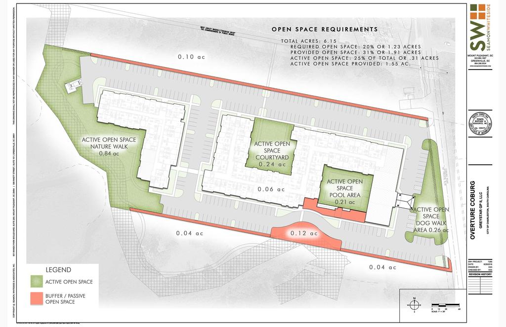
5 C I T Y O F C H A R L E S T O N P L A N N I N G C O M M I S S I O N Rezoning 1 : Coburg Rd (West Ashley) BACKGROUND The applicant is requesting a rezoning from General Business (GB) to Planned Unit Development (PUD). The subject property, located on the west side of Coburg Road just south of the West Ashley Greenway, is surrounded by General Business (GB) to the north, and Single-Family Residential (SR-1 & SR-2) zoning on all other sides. The subject property does not immediately abut any existing single-family uses but there are singlefamily homes across Coburg Road and across the marsh to the west of the subject property. The property to the south is undeveloped land. To the north of the subject property (beyond the Greenway) is an SCE&G electrical substation and a large shopping center. The subject property is currently undeveloped. The proposed Planned Unit Development (PUD) is on approximately 6.15 acres and primarily consists of senior housing units with a small amount of commercial space. The housing aspect is proposed to offer residential units for leaseholders 55 years and older and limited to a maximum of 198 total units (32.2 units per acre). Five percent of the units will be offered as income-qualified, affordable units. The proposed commercial space (maximum 5,000 sq ft) is proposed to be located along Coburg Road and hours of operation will be limited from 8:00am to 7:00pm. The property will contain 20% open space. The existing General Business (GB) zoning on the subject property allows many intense commercial uses with few restrictions on hours of operation. The maximum residential density currently allowed on this site is 26.4 units per acre (about 162 total units). CENTURY V CITY PLAN RECOMMENDATIONS The Century V Plan recommends maintaining the character of established areas in the City when considering the zoning of property. The subject property is designated in the Century V Plan as Suburban Edge which is characterized by predominantly residential uses at lower densities. Because the existing zoning allows a wide variety of commercial and multi-family uses, the proposed PUD zoning effectively reduces the potential impacts of future development by restricting uses and hours of operation on the site thereby bringing the property closer to the Century Plan s land use plan. The plan also encourages the inclusion of affordable housing in appropriate areas especially in close proximity to parks, bicycle/pedestrian facilities, public transit, schools and services. STAFF RECOMMENDATION APPROVAL WITH CONDITIONS TO BE DISCUSSED AT THE MEETING
 to Planned Unit Development (PUD). Owner: St.")

6 COBURG RD TIMMERMAN DR City of Charleston Planning Commission Area Rezoning 1 Coburg Rd (West Ashley) TMS# ac. Request rezoning from General Business (GB) to Planned Unit Development (PUD). Owner: St. Andrews Parish LLC Applicant: Seamon, Whiteside & Assoc. Inc Location ST LB SAVANNAH HWY ALYCIA ALY CRAVEN AVE SOTHEL AVE CA VALIER AVE HUGUENOT AVE LUDWELL ST GA RDENS CORNER CT COLLETON DR Departm ent of Planning, Preservation & Sustainability 2 George St, Charleston, SC

7
8
9 C I T Y O F C H A R L E S T O N P L A N N I N G C O M M I S S I O N Rezoning 2 : 1040 & th Ave (West Ashley) BACKGROUND The applicant is requesting a rezoning on two properties from Single-Family Residential (SR-2) and Diverse Residential-Mobile Home Park (DR-3) to Single-Family Residential (SR- 1). The subject properties, located on the north side of 5 th Avenue about a block from Saint Andrews Boulevard, consist of about 10.5 total acres. Surrounding zonings include Single-Family Residential (SR-1 & SR-2) in the City and Single-Family Residential (R4) and Saint Andrews Overlay District (OD-STA) in Charleston County. Surrounding uses include single-family development to the west, marsh/water areas and a City Park to the north and east and commercial uses across 5 th Avenue to the south. The subject property located at th Avenue (zoned SR-2) is occupied by a large single-family home on a 7.3 acre lot. The subject property located at th Avenue (zoned DR-3 Mobile Home Park) is occupied by a mobile home park. The existing SR-2 zoning district allows single-family development with a maximum density of 7.3 units per acre. The existing DR-3 zoning district allows a mobile home park on a minimum 2 acre lot but if the lot is not developed as a mobile home park, residential units with a density up to 9 units per acre may be placed on the site. The requested SR-1 zoning allows single-family homes (no mobile homes) at a density of 4.8 units per acre. CENTURY V CITY PLAN RECOMMENDATIONS The Century V Plan recommends maintaining the character of established areas in the City when considering the zoning of property. The subject properties are designated in the Century V Plan as Suburban which is characterized by mostly residential uses (density between 4 and 8 units per acre) and a few compatible commercial uses. Given the existing pattern of development in the surrounding neighborhood and the reduction in overall density allowed by the requested zoning district, the SR-1 zoning is appropriate for these properties. STAFF RECOMMENDATION APPROVAL
 and Diverse Residential-Mobile Home Park (DR-3) to Single-Family Residential (SR-1). Owner: Thomas C.")

10 City of Charleston Planning Commission Area Location Rezoning & th Ave (West Ashley) TMS# & ac. Request rezoning from Single-Family Residential (SR-2) and Diverse Residential-Mobile Home Park (DR-3) to Single-Family Residential (SR-1). Owner: Thomas C. Campbell, III; Campbell Knuppel Trailer Park LLC Applicant: Seamon, Whiteside & Assoc. Inc ST C ST DR-1F N HILLSIDE DR SAN JUAN AVE HILLSIDE DR ST DR-3 FORBES AVE GUNN AVE MA ZYCK ST SAINT ANDREWS BLVD FIALL ST MA MIE ST EAST ST 5TH AVE Departm ent of Planning, Preservation & Sustainability 2 George St, Charleston, SC
11 C I T Y O F C H A R L E S T O N P L A N N I N G C O M M I S S I O N Rezoning 4 : Nabors Dr and Affirmation Blvd (James Island) BACKGROUND The applicant is requesting rezoning from General Business (GB) and Single-Family Residential (SR-1) to Diverse Residential (DR-9). The properties are located between Nabors Drive and Affirmation Boulevard directly behind the shopping center on Harbor View Road. Four of the properties front on Nabors Drive and the larger property is located behind them. Only a portion of the highland acreage of the larger lot is proposed to be rezoned from GB to DR-9. Surrounding zonings include GB, DR-9, DR-1F, SR-1 and Planned Units Development (PUD) in the City and Single-Family Residential in the Town of James Island. Surrounding uses include the shopping center to the north, multi-family residential units to the south and west and single-family homes to the southwest on Nabors Drive. The properties are currently vacant except for a communications tower located in the northeast corner of the largest lot (on Affirmation Boulevard). The existing General Business (GB) zoning on the subject property allows many intense commercial uses with few restrictions on hours of operation and residential units with a density of up to 26.4 units per acre. The existing SR-1 zoning district allows single-family development with a maximum density of 4.8 units per acre. The requested DR-9 allows residential development in any format with a maximum density of 9 units per acre. CENTURY V CITY PLAN RECOMMENDATIONS The Century V Plan recommends keeping the character of established areas in the City when considering the rezoning of property. The Century V Plan map indicates the subject property is within an area designated as Neighborhood Center. Areas designated as such typically include a wide variety of uses, building types and residential densities ranging between 8 and 20 units per acre. Given the plan map designation and the existing mixed-use character of the area, the LB zoning is appropriate for this area. STAFF RECOMMENDATION APPROVAL


12 City of Charleston Planning Commission Area Location Rezoning 4 Nabors Dr and Affirmation Blvd (James Island) TMS# (a portion), 046, 047, 048 & 052 approx ac. Request rezoning from General Business (GB) and Single-Family Residential (SR-1) to Diverse Residential (DR-9). Owner: Anne Doscher Read & James Island Plantation Services Inc Applicant: ADC Engineering ST DR-9 ST SR-6 ST DR-1F NABORS DR AFFIRMATION BLVD ST PUD Departm ent of Planning, Preservation & Sustainability 2 George St, Charleston, SC
13 C I T Y O F C H A R L E S T O N P L A N N I N G C O M M I S S I O N Rezoning 5 : 1099 Playground Rd (West Ashley) BACKGROUND The applicant is requesting rezoning from Limited Business (LB) to General Business (GB). The subject property, located on the southwest corner of Ashley River Road and Playground Road, is surrounded by Limited Business (LB) zoning to the west and north, General Office (GO) zoning to the northwest across Ashley Road and Single-Family Residential (SR-2) zoning to the south in the City and Community Commercial (CC) zoning across Playground Road in Charleston County. Surrounding uses include the Saint Andrews Parks and Playgrounds park to the south, office, retail and restaurant immediately to the west, offices to the north and a shuttered car wash to the east. The existing use of the property is a daycare/preschool. CENTURY V CITY PLAN RECOMMENDATIONS The Century V Plan recommends keeping the character of established areas in the City when considering the rezoning of property. The Century V Plan map indicates the subject property is within an area designated as Highway District. Areas designated as such are more automotive intensive commercial uses although office and residential uses in a more urban format would be appropriate as well. Despite there being a wide variety of uses all along Ashley River Road, the block on the subject property sits on is made up of zonings that have less intensive commercial uses and restricted hours of operation. The same is true of the properties across Ashley River Road which back up to a single-family neighborhood. Because the requested General Business (GB) zonings could introduce more intense uses and potentially catalyze further extension of these uses along the entire block, the GB is not an appropriate fit for this area. STAFF RECOMMENDATION DISAPPROVAL
 to General Business (GB). Owner: Dr.")

14 City of Charleston Planning Commission Area Rezoning Playground Rd (West Ashley) TMS# ac. Request rezoning from Limited Business (LB) to General Business (GB). Owner: Dr. Helen Ross Location ST LB ST RO BROOKWOOD CIR HEATHWOOD DR ST LB ST LB ST GO ST LB ST LB ST RO WINSTON ST ASHLEY RIVER RD ST GO ST LB ST DR-1 PLAYGROUND RD Departm ent of Planning, Preservation & Sustainability 2 George St, Charleston, SC
15 C I T Y O F C H A R L E S T O N P L A N N I N G C O M M I S S I O N Rezoning 6 : 221 Spring St & 194 Cannon St (Peninsula) BACKGROUND The applicant is requesting a rezoning on two properties from General Business (GB) to Planned Unit Development (PUD). The subject properties, located between Spring and Cannon Streets near Courtenay Drive, are surrounded by General Business (GB) and Mixed-Use/Workforce Housing (MU-2/WH) zoning and Accommodations (A) overlay zoning. The subject properties are surrounded by hotels, retail, restaurants, offices, MUSC facilities, parking garages and ramps for the Ashley River Bridges (US Hwy 17). The property located at 194 Cannon Street is occupied by a former Wendy s restaurant building while the property located at 221 Spring Street is occupied by an existing Bruegger s Bagels restaurant. The proposed Planned Unit Development (PUD) is a result of plans generated from a partnership between the subject property owners, MUSC, WestEdge and the City and is a key redevelopment project in a rapidly changing part of the Charleston peninsula. Situated between MUSC and WestEdge, the subject properties are vital to new transportation connections and needed redevelopment of an area long considered to be an island of suburban format in a sea of urban context. One of the main goals of the proposed PUD is to allow for an extension of a key street connection from Hagood Avenue across Spring Street through the subject properties to Cannon Street. The proposed PUD includes accommodations uses with as many as 200 rooms, office, multi-family, retail and a parking garage. The PUD document contains design guidelines that ensure appropriate height scale and massing for this area of the City. The PUD proposes heights similar to the City s 85/125 Old City Height District and in-line with building heights in the adjacent WestEdge and MUSC areas. CENTURY V CITY PLAN RECOMMENDATIONS The Century V Plan recommends maintaining the character of established areas in the City when considering the zoning of property. The subject property is designated in the Century V Plan as Urban Core which is characterized by the densest and most mixeduse portions of the City. The proposed PUD meets the goals of the City plan in putting appropriate mixed-use developments in key infill areas of the City; especially downtown. STAFF RECOMMENDATION APPROVAL WITH CONDITIONS TO BE DISCUSSED AT THE MEETING
 to Planned Unit Development (PUD).")

16 City of Charleston Planning Commission Area Rezoning Spring St & 194 Cannon St (Peninsula) TMS# & 013 approx ac. Request rezoning from General Business (GB) to Planned Unit Development (PUD). Owner: Jem Management Co; Calfran Properties Applicant: Jonathan L. Yates - Hellman Yates & Tisdale Location ST DR-2F HAGOOD AVE STMU-2/WH SPRING ST VAUGHAN ST US1 7 COURTEN AY DR CA NNON ST RAMP CA NNON ST CH ERRY ST US1 7 BEE ST ST LB Departm ent of Planning, Preservation & Sustainability 2 George St, Charleston, SC
17 Approximate location of proposed ROW Hagood Extension Location of PUD to WestEdge development 22
18 Building Envelope: Maximum Building Envelope Plan Diagram (with proposed ROW & Bldg Setback 85/125) Maximum Building Envelope Massing Diagram (with proposed ROW) 23
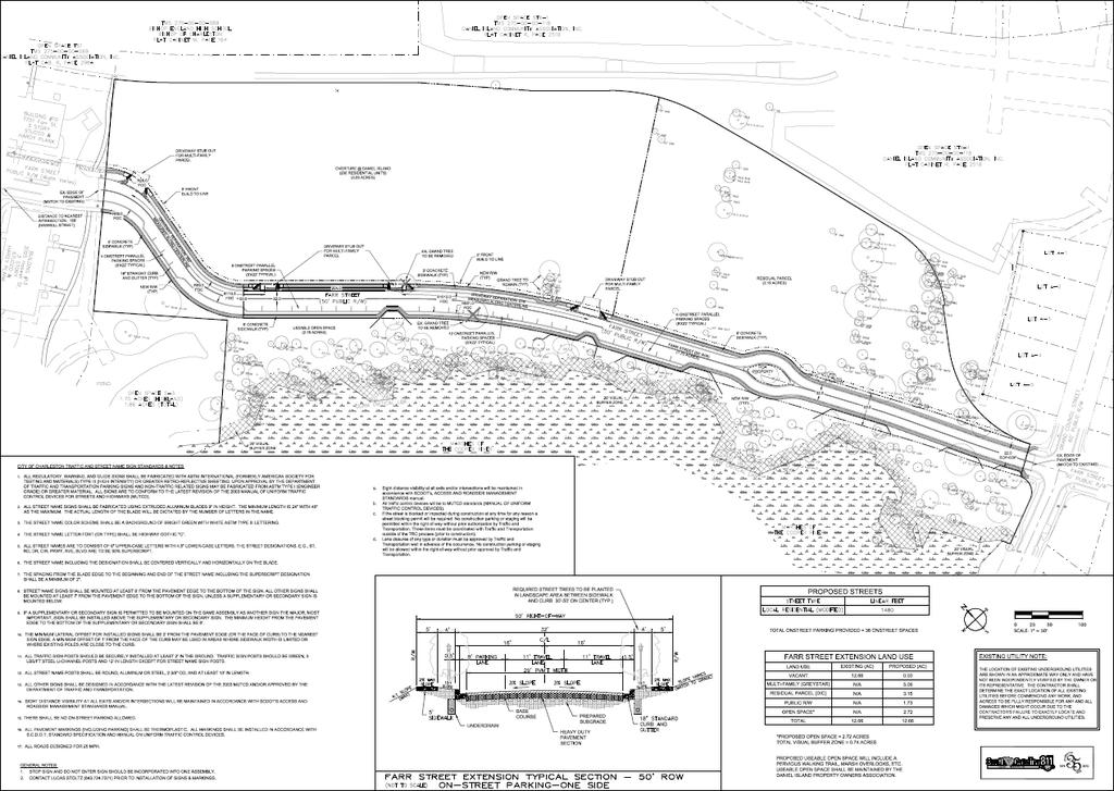
19 C I T Y O F C H A R L E S T O N P L A N N I N G C O M M I S S I O N Subdivision 1: Farr Street (Daniel Island) BACKGROUND The applicant is requesting subdivision concept plan approval for acres at Farr Street on Daniel Island. This project consists of the extension of the existing Farr Street rights-of-way to connect as a through street and the creation of two parcels for future residential development and one open space parcel. There is OCRM Critical Area adjacent to the site and there are grand trees on the site. The applicant will make a submittal to the Board of Zoning Appeals Site Design to resolve any tree conflicts. The City s Technical Review Committee (TRC) has reviewed the conceptual subdivision for compliance with City standards. The property is zoned Daniel Island Residential and the surrounding existing uses include primarily single-family and multi-family residential uses. STAFF RECOMMENDATION APPROVAL WITH CONDITIONS
. Owner: Greystar GP II LLC Applicant: Seamon, Whiteside & Assoc.")

20 City of Charleston Planning Commission Area Subdivision 1 Farr St Right-of-Way Extension (Peninsula) TMS# ac. 3 lots. Request subdivision concept plan approval. Zoned Daniel Island Residential (DI-R). Owner: Greystar GP II LLC Applicant: Seamon, Whiteside & Assoc. Inc Location ST LI TALISON AVE SEVEN FARMS DR ST DI-BP FARR ST CO CHRAN S T ST DI-GO BLAKEWAY ST ST DI-R ST DI-C ST DI-R GRAND COUNCIL ST ST LI ST DI-LI PCS TOWER RD IRVIN E LN FARR ST GIBBON ST Departm ent of Planning, Preservation & Sustainability 2 George St, Charleston, SC
21
22 C I T Y O F C H A R L E S T O N P L A N N I N G C O M M I S S I O N Zonings 1 through 3 : Recently Annexed Properties in West Ashley & James Island BACKGROUND The following zoning items are located in the West Ashley and James Island areas of the City and were recently annexed or the annexation is pending. The zoning districts recommended in the City closely match the zonings assigned to the properties in Charleston County or they are compatible with the context of the existing development or lot sizes in the surrounding neighborhoods. Zoning Item Property Address Acres Land Use Previous Zoning Recommended Zoning West Ashley Shadowmoss Pkwy 0.36 Single-Family Residential R-4 SR Arcadian Park 0.25 Single-Family Residential R-4 SR-1 James Island Woodland Shores Dr 0.30 Vacant Single-Family Resid. R-4 SR-1 CENTURY V CITY PLAN RECOMMENDATIONS The Century V Plan recommends maintaining the character of established areas in the City when considering the zoning of property. The subject properties are designated in the Century V Plan as Suburban or Suburban Edge which are predominately residential with varying, but lower densities. Given the existing pattern of development in the surrounding area the proposed zonings are appropriate for these sites. STAFF RECOMMENDATION APPROVAL ON ITEMS 1 THROUGH 3
.")

23 City of Charleston Planning Commission Area Zoning 1 14 Shadowmoss Pkwy (West Ashley) TMS# ac. Request zoning of Single-Family Residential (SR-1). Zoned Single-Family Residential (R-4) in Charleston County. Owner: Paula & Chris Iannuccilli Location SHADOWMOSS PKWY HUNTERS FOREST DR WA TERS EDGE CT Departm ent of Planning, Preservation & Sustainability 2 George St, Charleston, SC
. Zoned Single-Family Residential (R-4) in Charleston County.")

24 City of Charleston Planning Commission Area Zoning 2 7 Arcadian Park (West Ashley) TMS# ac. Request zoning of Single-Family Residential (SR-1). Zoned Single-Family Residential (R-4) in Charleston County. Owner: Kathleen & Josh Bell Location PENN AVE ARCADIAN PARK SAINT ANDREWS BLVD ARCADIAN WAY PEEKS PIKE OA KDALE P L Departm ent of Planning, Preservation & Sustainability 2 George St, Charleston, SC
.")

25 City of Charleston Planning Commission Area Zoning Woodland Shores Dr (James Island) TMS# ac. Request zoning of Single-Family Residential (SR-1). Zoned Single-Family Residential (R-4) in Charleston County. Owner: Rolina Homes LLC Location JEDEDIAH CT ST C ST DR-6 ST SR-4 STEFAN DR WOODLAND SH ORES RD Departm ent of Planning, Preservation & Sustainability 2 George St, Charleston, SC
26 C I T Y O F C H A R L E S T O N P L A N N I N G C O M M I S S I O N Zoning 4 : 336 Folly Rd (James Island) BACKGROUND The subject property, located near the corner of Folly Road and Tatum Street on James Island, was annexed into the City of Charleston on October 11, The property owner is requesting General Business (GB) zoning in the City. The property is Zoned Folly Road Corridor Overlay District (OD-FRC) in Charleston County. The zonings surrounding the subject property include SR-1, GB and General Office (GO) in the City and OD-FRC and R4 in Charleston County. Surrounding uses include an automotive repair and gas station, a small brewery, offices and fast food. The property is currently occupied by a dry cleaning business. CENTURY V CITY PLAN RECOMMENDATIONS The Century V Plan recommends keeping the character of established areas in the City when considering the zoning of property. The Century V Plan map indicates the subject property is within an area designated as Highway District. Areas designated as such are more automotive intensive commercial uses although office and residential uses in a more urban format would be appropriate as well. Given the existing use and the surrounding uses of higher of similar commercial intensity, the requested GB zoning is appropriate for this site. STAFF RECOMMENDATION APPROVAL
. Zoned Folly Road Corridor Overlay District (OD-FRC) in Charleston County.")

27 City of Charleston Planning Commission Area Zoning Folly Road (James Island) TMS# approx ac. Request zoning of General Business (GB). Zoned Folly Road Corridor Overlay District (OD-FRC) in Charleston County. Owner: George Smythe and David Smythe Location TATUM ST CROSSCREEK DR MA RTELLO DR FOLLY RD ST GO ST LB ST LB Departm ent of Planning, Preservation & Sustainability 2 George St, Charleston, SC MEANS ST
January 16, George St, Charleston, SC 5:00PM - Regular Meeting. CITY OF CHARLESTON Planning Commission Agenda Package FOR THE MEETING OF :
 CITY OF CHARLESTON Planning Commission Agenda Package FOR THE MEETING OF : 2 George St, Charleston, SC 5:00PM - Regular Meeting CITY OF CHARLESTON DEPARTMENT OF PLANNING, PRESERVATION AND SUSTAINABILITY
September 20, George St, Charleston, SC 5:00PM - Regular Meeting. CITY OF CHARLESTON Planning Commission Agenda Package FOR THE MEETING OF :
 CITY OF CHARLESTON Planning Commission Agenda Package FOR THE MEETING OF : September 20, 2017 2 George St, Charleston, SC 5:00PM - Regular Meeting CITY OF CHARLESTON DEPARTMENT OF PLANNING, PRESERVATION
CITY COUNCIL. a. Appointment of Jerome Heyward to the Charleston County Aviation Authority
 AMENDED City Hall 80 Broad Street October 9, 2018 5:00 p.m. CITY COUNCIL A. Roll Call B. Invocation Councilmember Shahid C. Pledge of Allegiance D. Presentations and Recognitions E. Public Hearings F.
2.2.2 The Land Use Setting
 2-6 Planning Area pearance varies dramatically from season to season. The absence of significant topographic or man-made features within the District contributes to a very open visual character that allows
PLANNING COMMISSION REPORT Regular Agenda Public Hearing Item
 PC Staff Report 6/20/16 Item No. 4-1 PLANNING COMMISSION REPORT Regular Agenda Public Hearing Item PC Staff Report 06/20/16 ITEM NO. 4: IG to CS 1.56 ACRES; 706 E 23 RD STREET (MKM) : Consider a request
Item # 9 September 13, 2006
 Item # 9 September 13, 2006 Planning and Development Department Land Use Planning Division To: From: Planning Commission Allan Gatzke Principal Planner Memorandum Date: September 13, 2006 Subject: Housing
Chapter 5: Testing the Vision. Where is residential growth most likely to occur in the District? Chapter 5: Testing the Vision
 Chapter 5: Testing the Vision The East Anchorage Vision, and the subsequent strategies and actions set forth by the Plan are not merely conceptual. They are based on critical analyses that considered how
Staff Report Dunes West (Wood Park Drive & Highway 41) For reference, the Zoning Code and Land Development Regulations are available online.
 For reference, the Zoning Code and Land Development Regulations are available online.") AGENDA ITEM Staff Report Dunes West (Wood Park Drive & Highway 41) For reference, the Zoning Code and Land Development Regulations are available online. PLANNED DEVELOPMENT AMENDMENT REQUEST PUBLIC HEARING:
AGENDA ITEM Staff Report Dunes West (Wood Park Drive & Highway 41) For reference, the Zoning Code and Land Development Regulations are available online. PLANNED DEVELOPMENT AMENDMENT REQUEST PUBLIC HEARING:
STAFF REPORT 1311/1321 Chuck Dawley Boulevard
 AGENDA ITEM STAFF REPORT 1311/1321 Chuck Dawley Boulevard For reference, the Zoning Code and Land Development Regulations are available online. REZONING REQUEST PUBLIC HEARING: Request to rezone from R-1,
Appendix A: Guide to Zoning Categories Prince George's County, Maryland
 Appendix A: Guide to Zoning Categories Prince George's County, Maryland RESIDENTIAL ZONES 1 Updated November 2010 R-O-S: Reserved Open Space - Provides for permanent maintenance of certain areas of land
APPENDIX B RESIDENTIAL DENSITY
 APPENDIX B RESIDENTIAL DENSITY RESIDENTIAL DENSITY - SPECIFIC AREAS OF THE CITY Policy Issue Examine specific areas of the City to determine appropriate residential densities. Public comments have expressed
PLANNING COMMISSION STAFF REPORT
 PLANNING COMMISSION STAFF REPORT REZONING CASE: RZ-16-001 REPORT DATE: March 8, 2016 CASE NAME: Trailbreak Partners Rezoning PLANNING COMMISSION DATE: March 16, 2016 ADDRESSES OF REZONING PROPOSAL: 5501
GENERAL PLAN UPDATE SPECIFIC AREAS OF THE CITY
 GENERAL PLAN UPDATE SPECIFIC AREAS OF THE CITY Background There are a total of 14 specific areas that are being reviewed as part of the update of the General Plan. Requests to review these areas came from
ARTICLE 3: Zone Districts
 ARTICLE 3: Zone Districts... 3-1 17.3.1: General...3-1 17.3.1.1: Purpose and Intent... 3-1 17.3.2: Districts and Maps...3-1 17.3.2.1: Applicability... 3-1 17.3.2.2: Creation of Districts... 3-1 17.3.2.3:
SUBJECT PARCEL(S) Property Owner(s) TMS Number Approximate Acreage Carolina Park Development, LLC
 Property Owner(s) TMS Number Approximate Acreage Carolina Park Development, LLC") Staff Report Special Planning Commission Meeting November 19, 2014 For reference, the Zoning Code and Land Development Regulations are available online. AGENDA ITEM 5c. SKETCH PLAN APPROVAL REQUEST: Request
Staff Report Special Planning Commission Meeting November 19, 2014 For reference, the Zoning Code and Land Development Regulations are available online. AGENDA ITEM 5c. SKETCH PLAN APPROVAL REQUEST: Request
PLANNING COMMISSION ANNEXATION, COMPREHENSIVE PLAN MAP AMENDMENT, AND ZONING MAP AMENDMENT CASE SUMMARY
 Subject Property: Applicant: PLANNING COMMISSION ANNEXATION, COMPREHENSIVE PLAN MAP AMENDMENT, AND ZONING MAP AMENDMENT CASE SUMMARY 385 SPEARS CREEK CHURCH ROAD ANNEX, ASSIGN LAND USE CLASSIFICATION UEMF
PRIMUS TRACT MOUNT PLEASANT, SOUTH CAROLINA
 DEVELOPMENT GUIDELINES FOR PRIMUS TRACT MOUNT PLEASANT, SOUTH CAROLINA Date February 18, 2015 PLANNING COMMISSION SUBMITTAL Owner/Developer: American Star Development SC, LLC P.O. Box 211 Sullivans Island,
Memorandum City of Lawrence Planning Department
 Memorandum City of Lawrence Planning Department TO: FROM: CC: Lawrence Douglas County Planning Commission Sandra Day, AICP, Planning Staff Applicant Date: January 14, 2013 RE: Item No. 3: Langston Heights
Faribault Place 3 rd Addition Preliminary Plat, Final Plat, & PUD
 Faribault Small Town Pride Big City Opportunities! December 5, 2016 Planning Commission Public Hearing Faribault Place 3 rd Addition Preliminary Plat, Final Plat, & PUD Location Maps Faribault 2 Requests
DEPARTMENT OF PLANNING
 : : DEPARTMENT OF PLANNING Jefferson Parish, Louisiana ZONING/LAND USE REPORT ADVERTISING DATES: 3-3-16 3-30-16 4-6-16 : - Paul D. Johnston AT LARGE: A - Chris Roberts B - Cynthia Lee-Sheng PAB PUBLIC
Council Public Meeting
 Agenda 3.1 a Council Public Meeting Department: Division: Subject: Planning and Regulatory Services Development Planning Request for Comments Zoning By-law Amendment and Draft Plan of Subdivision Applications
Marion County Board of County Commissioners
 Marion County Board of County Commissioners Date: 12/29/2015 P&Z: 12/28/2015 BCC: 1/12/2016 Item Number 160113Z Type of Application Rezoning Request From: A-1 (General Agriculture) To: PUD (Planned Unit
A. Land Use Relationships
 Chapter 9 Land Use Plan A. Land Use Relationships Development patterns in Colleyville have evolved from basic agricultural and residential land uses, predominate during the early stages of Colleyville
Planning Department Oconee County, Georgia
 Planning Department Oconee County, Georgia STAFF REPORT REZONE CASE #: 6985 DATE: October 31, 2016 STAFF REPORT BY: Andrew C. Stern, Planner APPLICANT NAME: Williams & Associates, Land Planners PC PROPERTY
Northwest Quadrant. Aerial Photographs. I th Ave Atlantic Ave 1 st St. SW 10 th /Atlantic SW 8 th /Atlantic
 Northwest Quadrant Aerial Photographs 12 th Ave Atlantic Ave 1 st St SW 10 th /Atlantic SW 8 th /Atlantic 12 th Ave 10 th Ave SW 10 th Ave SW 8 th Ave 2 nd St 3 rd St 36 Northwest Quadrant Neighborhood
ACTION FORM BRYAN CITY COUNCIL
 ACTION FORM BRYAN CITY COUNCIL DATE OF COUNCIL MEETING: July 8, 2014 DATE SUBMITTED: June 17, 2014 DEPARTMENT OF ORIGIN: Development Services SUBMITTED BY: Maggie Dalton MEETING TYPE: CLASSIFICATION: ORDINANCE:
PC Staff Report 11/18/2013 Z Item No. 1-1
 Z-13-00401 Item No. 1-1 PLANNING COMMISSION REPORT Regular Agenda - Public Hearing Item PC Staff Report 11/18/2013 ITEM NO. 1: Z-13-00401 IG (General Industrial) District TO CS (Strip Commercial) District;
MARION COUNTY GROWTH SERVICES
 MARION COUNTY GROWTH SERVICES Date: 6/5/27 P&Z: 5/31/27 BCC: 6/20/27 Item Number 270606Z Type of Application: Rezoning Request: FROM: A-1 (General Agriculture) TO: PUD (Planned Unit Development) for SFR
PUBLIC HEARING. ZMOD ASHBURN RESTAURANT PARK SIGN PLAN (Zoning Ordinance Modification)
") PUBLIC HEARING The LOUDOUN COUNTY PLANNING COMMISSION will hold a public hearing in the Board of Supervisors Meeting Room on the first floor of the County Government Center, 1 Harrison Street, S.E., Leesburg,
PUBLIC HEARING The LOUDOUN COUNTY PLANNING COMMISSION will hold a public hearing in the Board of Supervisors Meeting Room on the first floor of the County Government Center, 1 Harrison Street, S.E., Leesburg,
PLANNING COMMISSION REPORT Regular Agenda - Public Hearing Item
 Z-15-00469 Item No. 6A- 1 PLANNING COMMISSION REPORT Regular Agenda - Public Hearing Item PC Staff Report 11/16/15 ITEM NO. 6A GPI, RM12, & RS40 TO RM12; 14.756 ACRES; 5200 & 5300 CLINTON PKWY (SLD) Z-15-00469:
5/24/2018 RZ Page 1 of 3
 City of Sugar Hill Planning Staff Report RZ 18-004 DATE: May 24, 2018; Updated 6/5/2018 TO: Mayor and City Council FROM: Planning Director SUBJECT: Rezoning RZ 18-004 Ansley Hillcrest LLC, Hillcrest Drive
TOWN OF MOUNT PLEASANT, SOUTH CAROLINA PLANNING & DEVELOPMENT COMMITTEE OCTOBER 31, 2016 MINUTES. Municipal Complex, Building A, Public Meeting Room 1
 TOWN OF MOUNT PLEASANT, SOUTH CAROLINA PLANNING & DEVELOPMENT COMMITTEE OCTOBER 31, 2016 MINUTES Municipal Complex, Building A, Public Meeting Room 1 Members Present: Staff Present: Bob Brimmer, Joe Bustos,
United States Post Office and Multi-Family Residential; and, Single- Family Residence with an Apartment
 Planning Commission File No.: AME2013 0009 January 9, 2014 Page 2 of 9 Existing Land Use: United States Post Office and Multi-Family Residential; and, Single- Family Residence with an Apartment Surrounding
TOWN OF ORO VALLEY PLANNING & ZONING COMMISSION MEETING DATE: December 6, 2011
 PLANNING & ZONING COMMISSION MEETING DATE: December 6, 2011 TO: FROM: SUBJECT: PLANNING & ZONING COMMISSION Matt Michels, Senior Planner mmichels@orovalleyaz.gov; tel. 229-4822 Public Hearing: Rancho de
Plan Area and Current Facilities
 Plan Area and Current Facilities The Plan Area is bounded by South Delaware Street to the east and Concar Drive to the south (Figure 2.01). Parallel to Concar Drive on the south, SR 92 rises above grade
PLANNING ANALYSIS ZONING CASE 18-TOD-Z-026 NAK S CROSSING PUD AMENDMENT. GC-3-A (General Commercial) GC-3-A (General Commercial)
 GC-3-A (General Commercial)") PLANNING ANALYSIS ZONING CASE 18-TOD-Z-026 NAK S CROSSING PUD AMENDMENT GENERAL INFORMATION Applicant/Owner: Current Zoning: Bruce Nakfoor PUD/TOD (Planned Unit Development/Transit Oriented Development
PLANNING ANALYSIS ZONING CASE 18-TOD-Z-026 NAK S CROSSING PUD AMENDMENT GENERAL INFORMATION Applicant/Owner: Current Zoning: Bruce Nakfoor PUD/TOD (Planned Unit Development/Transit Oriented Development
Town of Frisco 2015 Land Use Profile
 Town of Frisco 2015 Land Use Profile I. Introduction The 2015 Land Use Profile correlates closely with several of the quality of life direction statements from the 2011 Frisco Community Plan. This study
8Land Use. The Land Use Plan consists of the following elements:
 8Land Use 1. Introduction The Land Use Plan consists of the following elements: 1. Introduction 2. Existing Conditions 3. Opportunities for Redevelopment 4. Land Use Projections 5. Future Land Use Policies
MSK HIGHWAYS 46 & 170
 HIGHWAYS & PARCEL SIZE: ±25.68 acres available either in whole or as 6 individual parcels ranging in size from 1.4 to 15.9 acres.. RETAIL LAND PARCELS Beaufort ZONING: Commercial under the jurisdiction
RM18 RS9 RM12 RS9 !( S DOCKET #: W3120 PROPOSED ZONING: GB-L EXISTING ZONING: HB-S. PETITIONER: Bank of North Carolina for property owned by Same
 DELANE DR DOCKET #: W3120 RM18 BARRY ST PROPOSED ZONING: GB-L RS9 EXISTING ZONING: HB-S IP OLD GREENSBORO RD WALES ST DENVER ST GEORGE BIG REDD CT LOUISE WILSON LN RM12!(DS MOSES LUCAS CT 585' 627' HB-S
PLANNING COMMISSION MEETING November 6, :00 P.M. COMMISSION ROOM/CITY HALL AGENDA
 City of Auburndale Auburndale, Florida 33823 #1 Bobby Green Plaza P. O. Box 186 Community Development Department Phone (863) 965-5530 Fax (863) 965-5507 PLANNING COMMISSION MEETING 4:00 P.M. COMMISSION
PARISH OF ASCENSION OFFICE OF PLANNING AND DEVELOPMENT PLANNING DEPARTMENT. Zoning Meeting
 PARISH OF ASCENSION OFFICE OF PLANNING AND DEVELOPMENT PLANNING DEPARTMENT 1. Meeting Called to Order by Chairman 2. Roll Call of Members 3. Minutes (A) Zoning Meeting February 13, 2019 Courthouse Annex
PLANNING COMMISSION REPORT Regular Agenda Public Hearing Item PRD TO RM15; ACRES; 2101 EXCHANGE CT (KES)
") PC Staff Report 7/22/15 Z-14-00515 Item No. 3-1 PLANNING COMMISSION REPORT Regular Agenda Public Hearing Item PC Staff Report 7/22/15 ITEM NO. 3 PRD TO RM15; 9.818 ACRES; 2101 EXCHANGE CT (KES) Z-14-00515:
PC Staff Report 7/22/15 Z-14-00515 Item No. 3-1 PLANNING COMMISSION REPORT Regular Agenda Public Hearing Item PC Staff Report 7/22/15 ITEM NO. 3 PRD TO RM15; 9.818 ACRES; 2101 EXCHANGE CT (KES) Z-14-00515:
PLANNING COMMISSION REPORT Regular Agenda Public Hearing Item
 PC Staff Report 11/12/12 Item No. 2B- 1 PLANNING COMMISSION REPORT Regular Agenda Public Hearing Item ITEM NO. 2B: A TO GPI; 110 ACRES; E OF K-10 & N OF W 6 TH ST (MKM) : Consider a request to rezone approximately
Planning and Zoning Commission STAFF REPORT REQUEST. DSA : Zone Change from R-3 (Multi-Family Residential) to B-4 (Community Services).
 to B-4 (Community Services).") Planning and Zoning Commission STAFF REPORT AGENDA # TO: FROM: PLANNING AND ZONING COMMISSION Joseph Horn, City Planner MEETING DATES: August 4, 2016 SUBJECT: Gino Tarantini zone change requests REQUEST
Planning and Zoning Commission STAFF REPORT AGENDA # TO: FROM: PLANNING AND ZONING COMMISSION Joseph Horn, City Planner MEETING DATES: August 4, 2016 SUBJECT: Gino Tarantini zone change requests REQUEST
PLANNING COMMISSION REPORT Regular Agenda - Public Hearing Item
 Z-12-29, 30, 32, 33, 34, 35, 36-11 to Item No. 5A 5G- 1 PLANNING COMMISSION REPORT Regular Agenda - Public Hearing Item PC Staff Report 02/27/2012 ITEM NO. 5A-5G Z-12-29, 30, 32, 33, 34, 35, 36-11 from
CITY OF ELK GROVE CITY COUNCIL STAFF REPORT
 AGENDA ITEM NO. 9.2 CITY OF ELK GROVE CITY COUNCIL STAFF REPORT AGENDA TITLE: A public hearing to consider a Specific Plan Amendment to the Laguna Ridge Specific Plan and a Rezone of approximately 4.14
INDIAN RIVER COUNTY, FLORIDA. The Honorable Members of the Planning and Zoning Commission DEPARTMENT HEAD CONCURRENCE
 Public Hearing Legislative INDIAN RIVER COUNTY, FLORIDA M E M O R A N D U M TO: The Honorable Members of the Planning and Zoning Commission DEPARTMENT HEAD CONCURRENCE Robert M. Keating, AICP; Community
RAE EXCLUSIVE RESIDENTIAL ZONE A residential district exclusively for low density single family housing and accessory uses.
 KNOX COUNTY ZONING ORDINANCE DISTRICT SUMMARY REQUIREMENTS 2/11/2009 RAE EXCLUSIVE RESIDENTIAL ZONE A residential district exclusively for low density single family housing and accessory uses. 10,000 sq.
CITY OF MURFREESBORO BOARD OF ZONING APPEALS
 CITY OF MURFREESBORO BOARD OF ZONING APPEALS Regular Meeting, September 26, 2012, at 1:00 p.m. City Hall, 111 West Vine Street, Council Chambers, 1 st Floor 1. Call to order A G E N D A 2. Consideration
STAFF REPORT. Community Development Director PO Box 4755 Beaverton, OR 97076
 STAFF REPORT HEARING DATE: July 7, 2010 TO: Planning Commission STAFF: Jana Fox, Assistant Planner PROPOSAL: Southeast Beaverton Office Commercial Zoning Map Amendment (ZMA2010-0006) LOCATION: The subject
General Plan. Page 44
 VIII. RESIDENTIAL DEVELOPMENT IN NON-RESIDENTIAL LAND USE AREAS POLICY ISSUE Review the City s existing regulations and policies that allow residential land use in non-residential zoning districts. BACKGROUND
PLANNING COMMISSION REPORT Regular Agenda - Public Hearing Item
 Z-11-25-09; Z-11-26-09; Z-11-28-09 Item No. 2-1 PC Staff Report 3/28/11 PLANNING COMMISSION REPORT Regular Agenda - Public Hearing Item ITEM NO. 2A RM32 TO MU;.19 ACRES; 1340 TENNESSEE ST (MJL) Z-1-1-11:
DEPARTMENT OF PLANNING
 DEPARTMENT OF PLANNING Jefferson Parish, Louisiana ZONING/LAND USE REPORT : : (S) Cynthia Lee-Sheng AT LARGE: A Chris Roberts B Elton M. Lagasse ADVERTISING DATES: 0/06/1 0/13/1 0/20/1 PAB PUBLIC HEARING:
Highland Green Estates Neighbourhood Area Structure Plan
 Highland Green Estates Neighbourhood Area Structure Plan Original Outline Plan approved by Council: March 10, 1997 Outline Plan amended by Council: March 24, 1997 Converted to a Neighbourhood Area Structure
EXHIBIT D. WRITTEN DESCRIPTION For. TOWNSEND VILLAGE PUD December 23, 2015 (Revised)
") I. PROJECT DESCRIPTION EXHIBIT D WRITTEN DESCRIPTION For TOWNSEND VILLAGE PUD December 23, 2015 (Revised) A. This 7.2 acre single-family residential project is located on the East side of Townsend Boulevard,
I. PROJECT DESCRIPTION EXHIBIT D WRITTEN DESCRIPTION For TOWNSEND VILLAGE PUD December 23, 2015 (Revised) A. This 7.2 acre single-family residential project is located on the East side of Townsend Boulevard,
PLANNING COMMISSION WILLIAMSBURG, VIRGINIA WORK SESSION AGENDA Wednesday, May 23, 2012
 PLANNING COMMISSION WILLIAMSBURG, VIRGINIA WORK SESSION AGENDA Wednesday, May 23, 2012 The meeting will be called to order in the third floor Conference Room (Room 310), Williamsburg Municipal Building,
PLANNING BOARD AGENDA
 PLANNING BOARD AGENDA Public Hearing and Administrative Meeting Wednesday,, 1:30 P.M. Omaha/Douglas Civic Center 1819 Farnam Street Legislative Chamber DISPOSITION AGENDA This document states the disposition
CITY OF TARPON SPRINGS Staff Report May 16, 2017
 CITY OF TARPON SPRINGS Staff Report May 16, 2017 TO: FROM: HEARING DATES: SUBJECT: MAYOR & BOARD OF COMMISSIONERS PLANNING & ZONING DEPARTMENT MAY 15, 2017 (PLANNING & ZONING BOARD) JUNE 6, 2017 (BOC 1
Demographics Review Multi-family Housing Data & Characteristics. Triplexes, quadplexes, and apartments. Development Potential Future Considerations
 Horizon Discussion: Arlington 2012 Multi-Family Housing Profile City Council Meeting September 17, 2013 6 Overview Demographics Review Multi-family Housing Data & Characteristics Triplexes, quadplexes,
NOTICE OF MEETING AND AGENDA FOR THE PLANNING COMMISSION OF SPRINGVILLE, UTAH... JANUARY 23, 2018
 NOTICE OF MEETING AND AGENDA FOR THE PLANNING COMMISSION OF SPRINGVILLE, UTAH............................ JANUARY 23, 2018 Notice is hereby given that the Planning Commission will hold a public meeting
Department of Planning & Development Services
 Department of Planning & Development Services S T A F F R E P O R T August 29, 2014 CASE NO: PROJECT: EXECUTIVE SUMMARY: DETAILS: ZA14-102 Zoning Change and Development Plan for the Carillon Corporate
DEPARTMENT OF PLANNING AND COMMUNITY DEVELOPMENT STAFF REPORT
 DEPARTMENT OF PLANNING AND COMMUNITY DEVELOPMENT STAFF REPORT PLANNING COMMISSION AGENDA ITEM # 5: Project Name: Star Dance Zoning Map Amendment, ZMA-13-02 Prepared By: Toby Stauffer, AICP City Planner
ZONING CLASSIFICATION SUMMARY SHEET
 Growth and Resource Management Planning and Development Services 123 West Indiana Avenue Room 202 DeLand, Florida 32720-4253 Telephone (386) 943-7059 Fax (386) 626-6570 www.volusia.org ZONING CLASSIFICATION
Action Recommendation: Budget Impact:
 City of Fayetteville Staff Review Form 2017-0451 Legistar File ID 9/5/2017 City Council Meeting Date - Agenda Item Only N/A for Non-Agenda Item Andrew Garner Submitted By 8/18/2017 Submitted Date Action
PLANNING AND DEVELOPMENT SERVICES STAFF REPORT. For Planning Commission Meeting of May 6, 2014
 PLANNING AND DEVELOPMENT SERVICES STAFF REPORT For Planning Commission Meeting of May 6, 2014 SUBJECT: Amendments to Chapter 55 ( Ordinance) regarding Building and Requirements in the Main Street Character
WHEREAS, the Planning and Zoning Commission, at its meeting on July 9, 2018, recommended the approval of the zoning request by the City Council; and
 BILL NO. ORDINANCE NO. AN ORDINANCE ESTABLISHING A LI: LIGHT INDUSTRIAL DISTRICT FOR PROPERTY RECENTLY ANNEXED INTO THE CITY OF WARRENSBURG, MISSOURI, LOCATED AT THE NORTHEAST CORNER OF THE INTERSECTION
MINUTES OF THE TOWN OF LADY LAKE REGULAR PLANNING AND ZONING BOARD MEETING LADY LAKE, FLORIDA. May 8, :30 p.m.
 MINUTES OF THE TOWN OF LADY LAKE REGULAR PLANNING AND ZONING BOARD MEETING LADY LAKE, FLORIDA May 8, 2017 5:30 p.m. The Planning and Zoning Board Meeting was held in the Town Hall Commission Chambers at
Cozy by Design Communities for the 21 st Century
 Cozy by Design Communities for the 21 st Century Rome 5,150/sq mi London 11,000/sq mi Paris 64,000/sq mi Phoenix 2,700/ sq mi Kowloon 154,000/sq mi Amsterdam 11,200/sq mi Athens 26,500/ sq mi Coziness
City of Greer - Planning and Zoning Division Minutes PLANNING COMMISSION MEETING March 20, 2017
 City of Greer - Planning and Zoning Division Minutes PLANNING COMMISSION MEETING Members Present: Mr. Foster, Ms. Jones, Mr. Hopper, Mr. Montgomery, Ms. Traenkle, Mr. Martin and Chairman Tumblin Member(s)
Implementation. Approved Master Plan and SMA for Henson Creek-South Potomac 103
 Implementation Approved Master Plan and SMA for Henson Creek-South Potomac 103 104 Approved Master Plan and SMA for Henson Creek-South Potomac Sectional Map Amendment The land use recommendations in the
City Recorder s Office
 City Recorder s Office PUBLIC NOTICE Notice is Hereby Given that the Tooele City Council & Tooele City Redevelopment Agency will meet in a Work Session, on Wednesday, September 19, 2018 at the hour of
Town of Cary, North Carolina Rezoning Staff Report 12-REZ-27 Morris Branch Town Council Public Hearing January 24, 2013
 Town of Cary, North Carolina Rezoning Staff Report 12-REZ-27 Morris Branch Town Council Public Hearing January 24, 2013 REQUEST To amend the Town of Cary Official Zoning Map to rezone approximately 9.0
LAND USE ASSUMPTIONS REPORT POTENTIAL FUTURE DEVELOPMENT WEST WHITELAND TOWNSHIP, CHESTER COUNTY, PA
 LAND USE ASSUMPTIONS REPORT POTENTIAL FUTURE DEVELOPMENT WEST WHITELAND TOWNSHIP, CHESTER COUNTY, PA Adopted June 17, 2015 by Township Resolution No. 2015-30 Prepared by Theurkauf Design & Planning, LLC
REPORT TO THE SHELBY COUNTY PLANNING COMMISSION From the Department of Development Services Planning Services. February 4, 2019
 REPORT TO THE SHELBY COUNTY PLANNING COMMISSION From the Department of Development Services Planning Services February 4, 2019 Case No. Request for Rezoning Approval From E-1 to E-2 SD This is a request
Rural Living (RL) Rural Living
 Rural Living") Place Types Rural Living (RL) Rural Living Rural living areas are characterized by very large lots, abundant open space, pastoral views, and a highdegree of separation between buildings. The lots are typically
Place Types Rural Living (RL) Rural Living Rural living areas are characterized by very large lots, abundant open space, pastoral views, and a highdegree of separation between buildings. The lots are typically
CITY COUNCIL STUDY SESSION MEMORANDUM
 City and County of Broomfield, Colorado To: From: Prepared by: Owner Applicant Property Size Property Location: CITY COUNCIL STUDY SESSION MEMORANDUM Mayor and City Council Charles Ozaki, City and County
M E M O. September 14, 2017 Agenda Item #4. Planning Commission. David Goodison, Planning Director
 September 14, 2017 Agenda Item #4 M E M O To: From: Planning Commission David Goodison, Planning Director Re: Preliminary review of an application for a mixed-use development proposed for 870 Broadway
January 7, Sarah Smith Community Development Director City of Mound 5341 Maywood Road Mound, MN Dear Ms. Smith,
 January 7, 2019 Sarah Smith Community Development Director City of Mound 5341 Maywood Road Mound, MN 55364 Dear Ms. Smith, We are pleased to present the enclosed concept plan and requisite attachments
CITY PLANNING COMMISSION AGENDA
 Page 60 CITY PLANNING COMMISSION AGENDA ITEM NO: C STAFF: MICHAEL SCHULTZ FILE NO: CPC UV 14-00023 QUASI-JUDICIAL PROJECT: APPLICANT: OWNER: 1534 & 1536 W. CHEYENNE ROAD JOHN DWORAK ESTATES OF ELAINE DWORAK
CITY OF PORT ORCHARD
 CITY OF PORT ORCHARD ZONING DESIGNATIONS (Adapted from POMC Chapter 20.34 Zoning Districts, as adopted 6/13/2017) 20.34.110 Greenbelt zone (Gb). (1) Purpose. It is the purpose of the greenbelt zone to
Agenda Numbers: PC15-14 MEETING DATE: July 7, 2015 REPORT TO THE PLANNING COMMISSION
 Agenda Numbers: PC15-14 MEETING DATE: July 7, 2015 REPORT TO THE PLANNING COMMISSION SUBJECT: Patton Computers, 264 Market Boulevard (The Market on Poplar, Lot #1) - Request approval of a Conditional Use
TOWN OF KIAWAH ISLAND. TOWN COUNCIL PUBLIC HEARING Kiawah Island Municipal Center Council Chambers AGENDA. CalitoOrder: II.
 Ordinance Ordinance TOWN OF KIAWAH ISLAND 21 BEACH WALKER DRIVE KIAWAH ISLAND. Sc 29455 (843) 768-9166 FAX (843) 768-4764 Mayor Craig E. Weaver TOWN COUNCIL PUBLIC HEARING Kiawah Island Municipal Center
TREASURE COAST REGIONAL PLANNING COUNCIL M E M O R A N D U M
 TREASURE COAST REGIONAL PLANNING COUNCIL M E M O R A N D U M To: Council Members AGENDA ITEM 6A From: Date: Subject: Staff May 20, 2011 Council Meeting Local Government Comprehensive Plan Review Draft
Marion County Board of County Commissioners
 Marion County Board of County Commissioners Date: 12/2/25 P&Z: 11/30/25 BCC: 12/16/25 Amendment No: (20)151209Z Type of Application Rezoning Request P-MH (Mobile Home Park) to B-2 (Community Business)
Columbia Development Tracker
 Columbia Development Tracker October 1, 2018 The Columbia Development Tracker incorporates projects or development proposals going through their entitlement and/or planning review process. The tracker
STAFF SUMMARY OF Z17-10 CONDITIONAL ZONING DISTRICT APPLICATION
 STAFF SUMMARY OF Z17-10 CONDITIONAL ZONING DISTRICT APPLICATION APPLICATION SUMMARY Case Number: Z17-10 Request: Conditional B-2 Zoning District in order to expand an existing retail and warehousing business
Action Recommendation: Budget Impact:
 City of Fayetteville Staff Review Form 2018-0477 Legistar File ID 9/18/2018 City Council Meeting Date - Agenda Item Only N/A for Non-Agenda Item Garner Stoll Submitted By 8/28/2018 Submitted Date Action
ARLINGTON COUNTY, VIRGINIA
 ARLINGTON COUNTY, VIRGINIA County Board Agenda Item Meeting of December 8, 2012 DATE: November 29, 2012 SUBJECT: PDSP #346 SITE PLAN AMENDMENT to convert approximately 1,458 square feet of GFA below-grade
THE AREA PLAN COMMISSION OF ST. JOSEPH COUNTY, IN AGENDA
 THE AREA PLAN COMMISSION OF ST. JOSEPH COUNTY, IN AGENDA Tuesday, January 17, 2017 Fourth-Floor Council Chambers 3:30 p.m. County-City Building, South Bend, IN EXECUTIVE SESSION: A. Election of Officers
TREASURE COAST REGIONAL PLANNING COUNCIL M E M O R A N D U M. To: Council Members AGENDA ITEM 10A
 TREASURE COAST REGIONAL PLANNING COUNCIL M E M O R A N D U M To: Council Members AGENDA ITEM 10A From: Date: Subject: Staff April 20, 2007 Council Meeting Local Government Comprehensive Plan Review Draft
Marion County Board of County Commissioners
 Marion County Board of County Commissioners Date: 12/2/2015 P&Z: 11/30/2015 BCC: 12/16/2015 Item Number 151210SU Type of Application Special Use Permit Request To establish a Clay Electric Co-Operative
NEC K-7 & Shawnee Mission Parkway
 FIRST TIME OFFERING 68+/- Acres of Prime Development Land For Sale: NEC K-7 & Shawnee Mission Parkway Shawnee, Johnson County, KS Supporting Land Use Information & Data INTRODUCTION CONTEXT Location: The
Pentagon Centre (SP#297) PDSP & Phase I Site Plan Amendments SPRC #1
 PDSP & Phase I Site Plan Amendments SPRC #1") Pentagon Centre (SP#297) PDSP & Phase I Site Plan Amendments SPRC #1 CPHD February 23, 2015 Meeting Agenda Background on relevant planning context, guidance, and County policy Brief update on original
Pentagon Centre (SP#297) PDSP & Phase I Site Plan Amendments SPRC #1 CPHD February 23, 2015 Meeting Agenda Background on relevant planning context, guidance, and County policy Brief update on original
3. Proof of Publication and Waive the Reading of the Legal Advertisement.
 AGENDA ESCAMBIA COUNTY PLANNING BOARD QUASI-JUDICIAL HEARING April 1, 2013 8:30 a.m. Escambia County Central Office Complex 3363 West Park Place, Room 104 1. Call to Order. 2. Invocation/Pledge of Allegiance
Zoning Administrator Agenda Report Meeting Date 6/12/2018
 Zoning Administrator Agenda Report Meeting Date 6/12/2018 DATE: May 30, 2018 TO: ZONING ADMINISTRATOR File: UP 18-03 FROM: Kimber Gutierrez, Associate Planner, 530-879-6810, kimber.gutierrez@chicoca.gov
PAPRlamird4-Lairds Corner
 PAPRlamird4-Lairds Corner Lamird Report This report provides the written record of local circumstances that explains how the Lairds Corner LAMIRD ( this lamird ) fits within the rural element goals of
July 18, 2017 Planning & Zoning Meeting 6:30 p.m.
 July 18, 2017 Planning & Zoning Meeting 6:30 p.m. Date: July 18, 2017 PLANNING AND ZONING MEETING ATTENDANCE LIST Commissioners Position Present Absent R.G. Reeder Bill Bonham Greg Smith Leslie Boudwin
SHEPHERD COMMUNITY ZONING STUDY SPECIAL STUDY. September 21, Regional Planning Agency
 SPECIAL STUDY SHEPHERD COMMUNITY ZONING STUDY September 21, 2007 Regional Planning Agency Chattanooga-Hamilton County Regional Planning Agency Development Resource Center 1250 Market Street Chattanooga,
5. Housing. Other Relevant Policies & Bylaws. Several City-wide policies guide our priorities for housing diversity at the neighbourhood level: Goals
 5. Housing Other Relevant Policies & Bylaws Several City-wide policies guide our priorities for housing diversity at the neighbourhood level: Goals 1. Encourage more housing diversity while maintaining