University District Specific Plan
|
|
|
- Myrtle Hall
- 5 years ago
- Views:
Transcription

1 University District Specific Plan City of Rohnert Park City Council April 8, 2014

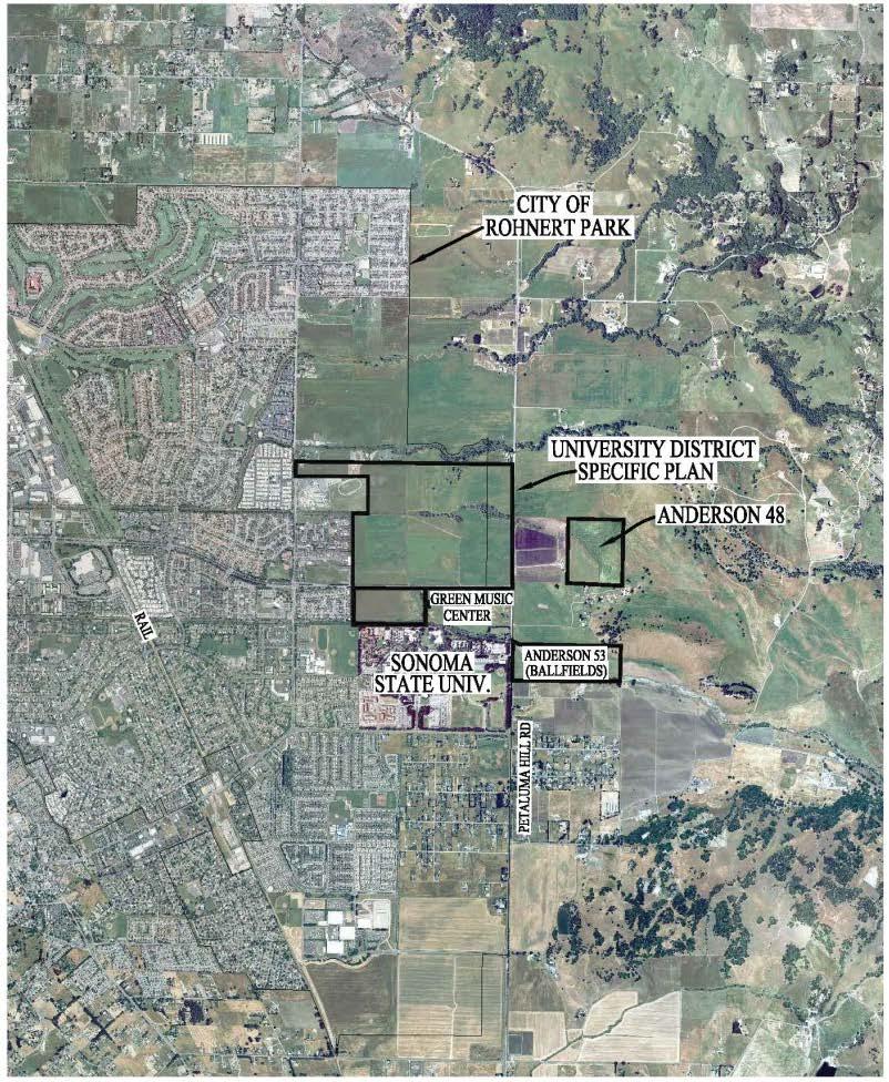
2 Project Vicinity Map
3 Aerial Photograph
4 Requested Entitlements Rescission of Tentative Maps and Development Area Plans approved in 2006 EIR Addendum General Plan Amendment Revised Specific Plan Tentative Map (Vast Oak property) Tentative Parcel Map (UDLLC property) Amended and Restated Development Agreement
5 Planning Commission Action Hearing held March 13, 2014 Commissioners unanimously voted to approve resolutions recommending City Council approval of requested entitlements
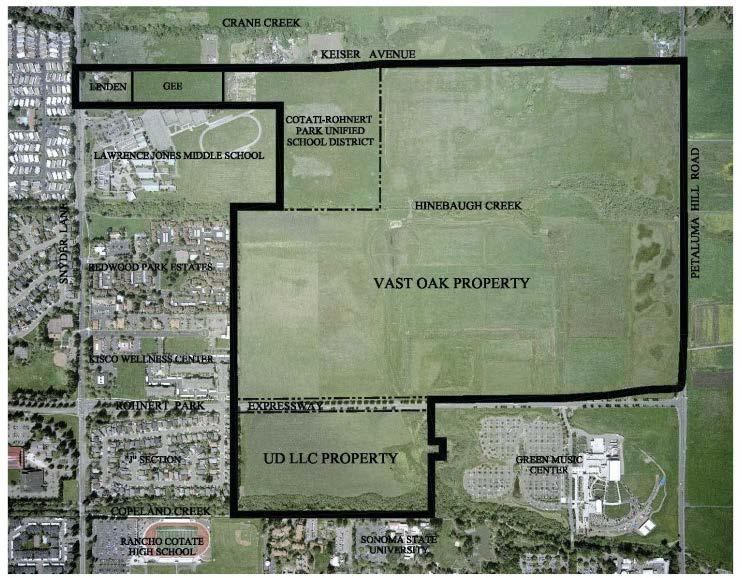
6 Existing Approved Project University District Specific Plan (UDSP) Background: One of five specific plan areas designated in GP 300 acres of land, five property owners Specific Plan approved and EIR adopted in ,645 residential units plus 126 second units 175,000 sf commercial building area 5 park areas U.D. LLC property: less than 1.0 acre total park land Vast Oak property: approx acres total park land (3 parks and plaza) CRPUSD property: approx. 2.0 acres total park land

7 Existing Land Use Plan
8 Proposed Project Specific Plan Revisions: Same total residential unit count (1,645) with revised number of units per land use designation Modified gross acreages and configurations for land uses Reduction of commercial building area Increased total park acreage Larger and more useful parks that will be more efficient to maintain
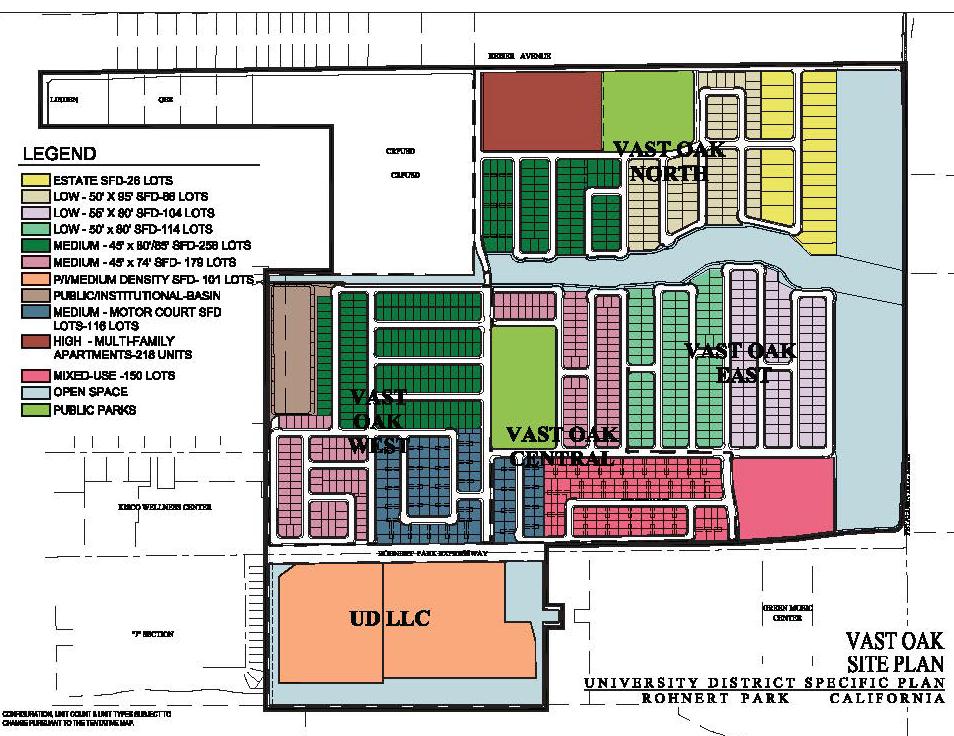
9 Site Plan
10 Rescission of 2006 Resolutions : Tentative Map (UDLLC) : Tentative Map (Vast Oak) : Development Area Plan (UDLLC) : Development Area Plan (Vast Oak)
11 General Plan Amendments GP Table (2014 project amendments shown in yellow) Land Use Designation 2006 Gross Acreage 2014 Gross Acreage 2006 Housing Units 2014 Housing Units 2006 Building Area (1,000sf) 2014 Building Area (1,000sf) Rural Estate Residential Low Density Residential Medium Density Residential High Density Residential Public/Institutional Mixed Use Max. of Parks Plaza Linear Park Open Space & Buffers Copeland Creek Crane Creek Hinebaugh Creek Petaluma Hill Rd Buffer Totals ,415-1,645 1,400-1,645 Max. of


12 General Plan Amendments GP Text and Figure Amendments Amendments to UDSP Area on GP Land Diagram (Figure 2.2-1)
13 General Plan Amendments List of GP Text Amendments: Amend High Density Residential text on page 2-20 to clarify that specific plans may modify the range of housing types permitted within the designation. Amend text on page 2-21 and 2-22 for clarification of Public/Institutional/Medium Density Residential and Commercial-R/High Density land use designations. Amend Table to reflect revised acreage totals. Amend Policy LU-15 to include amended principles. Amend Table 2.4-1, Land Use Program: University Specific Plan Area, to reflect the Project, as proposed. Amend Policy CD-2 to change linear park to linear parkway and change public plaza to private plaza. Amend Figure to reflect the proposed land use configuration. Amend Policy CD-31 to delete references to Figure and Figure
14 General Plan Amendments Amend Policy CD-32 to change public plaza to private plaza. Amend Policy CD-33 to change linear park to linear parkway and delete reference to Figure Delete Figures 3.2-7, 3.2-8, and Amend Policy CD-35 to revise open space and parks description. Amend Policy CD-36 to add Low Density Residential and Mixed Use. Amend Policy CD-38 to change two way spine road to linear parkway. Amend Figures 4.1-1, 4.1-2, and Figure to reflect the proposed land use configuration. Delete Policy TR-8, a policy which requires a north-south spine road through the UDSP area. Amend Figures 5.1-1, 5.1-2, 5.2-1, and to reflect the proposed land use configuration. Amend Policy OS-2 to correct reference to Policy CD-34 and revise the minimum acreage for the UDSP open space buffer.
15 General Plan Amendments Amend Table 5.2-2, New Parks under the General Plan, to reflect amended park acreage for the University District. Amend Figures 6.2-2, 7.1-1, 7.1-2, 7.2-1, 7.2-2, and to reflect the proposed land use configuration. Amend Housing Element, Table to reflect amended total housing units. Amend Housing Element, University District Specific Plan Area (page 9-62) to reflect amended acreages and unit counts. Amend Housing Element, Table to reflect revised unit counts. Amend Housing Element, Appendix A, Policy HO-2 to reflect information related to the revised Specific Plan. Amend Housing Element, Appendix A, Policy HO-27 to reflect revised unit counts. Amend Housing Element Appendix C: Rohnert Park Housing Sites Figure to reflect revised unit counts.
16 Revised Specific Plan Residential Land Uses Acreages and Units Rural Estate - Total acreage/units consistent with 2006 Plan 2006: acres, 26 units 2014: acres, 26 units Low Density Slight increase in acreage/units 2006: acres, 320 units 2014: 66.88, 382 units Medium Density Increase in acreage/units 2006: acres, 537 units 2014: acres, 666 units Public / Institutional / Medium Density New designation (UDLLC property) 2014: acres, 203 units High Density Decrease in acreage/units 2006: acres, 612 units 2014: 9.12 acres, 218 units Mixed Use/Commercial No change in total units 2006: 150 units 2014: 150 units
17 Revised Specific Plan Commercial Land Uses Total Acreage consistent with 2006 Plan 2006: acres 2014: acres Decrease in total commercial building area 2006: 175,000 sf 2014: 100,000 sf Public Plaza 2006: public plaza 2014: private plaza
18 Revised Specific Plan Open Space/Wetlands/Basin Locations and total acreages same as 2006 Plan Open space/wetland preservation areas Same as included in the 2006 Plan Wetlands and preserve area completed along Petaluma Hill Road
19 Revised Specific Plan Parks and Open Space Total Acreage 2006: acres 2014: acres Parks Concept 2006: Linear Park trail concept 2014: Altered Linear Parkway concept based on shift of MU/Commercial Center. Larger active park to serve as focal point of community. Class I Bike Trails Both sides of Hinebaugh Creek Connect to existing City trails Vehicular/pedestrian/bike trail bridge Trails to be owned by City, maintained by VO/UDLLC Homeowner s Association

20 Twin Creeks Park

21 Oak Grove Park

22 Bicycle and Pedestrian Circulation Plan

23 Revised Specific Plan Comparison of land use locations LDR HDR P LDR P/I MDR MDR HDR HDR MU P LDR MDR HDR MU P MDR LDR RE LDR OS OS P/I MDR P/I MDR OS MDR P LDR LDR MU RE OS MDR HDR P P/I/MDR OS High Density: Shifted north adjacent to Keiser Avenue, west of park Mixed Use: Shifted to eastern edge of the development area across from the GMU Public/Institutional/Medium Density: New land use designation for area south of RPX Parks: Two larger parks on Vast Oak property with greater total acreage.


24 Revised Specific Plan Development Phasing Phasing Plan Phase I (VO West)
25 Design Guidelines Appendix B of Revised Specific Plan Planning and design fundamentals for pedestrian friendly neighborhoods with defined architecture and landscaping Guidelines and standards provided for: Site and architecture for residential and mixed use areas; Residential architectural styles; and Landscaping, park and open space concepts
26 Tentative Map (Vast Oak) acres south of Keiser Avenue and north of Rohnert Park Expressway 1,033 single family residential lots 2 parcels for future neighborhood parks 1 parcel for water quality detention basin 4 parcels for open space 1 parcel for high density residential 1 parcel for mixed use/commercial Phased infrastructure Twin Creeks Park and Oak Grove Park Class I Bike Trails, bridge across Hinebaugh Creek Linear Parkway

27 Tentative Map (Vast Oak)
28 Tentative Parcel Map (UDLLC) acre UDLLC Property Three-lot tentative parcel map Parcel A (8.91 acres) - open space/buffer Parcel B (10.88 acres) - medium density residential and/or a temporary water quality and detention basin Parcel C (14.55 acres) - medium density residential

29 Tentative Parcel Map (UDLLC)
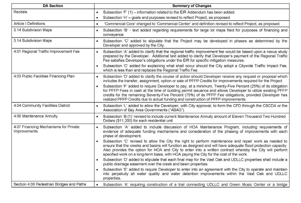
30 Development Agreement Original DA entered into in Amended and Restated DA for development of Vast Oak and UDLLC properties Roadway Improvements and Regional Traffic Fees Public Facilities Finance Plan (PFFP) Fees Growth Management Program Maintenance of City Services and Facilities Affordable Housing Plan
 Permanent UDLLC Basin UDSP Plan Area Anderson 53")
31 Development Agreement Detention Basins Temporary UDLLC Basin Regional Detention Basin (Anderson 53 Property) Permanent UDLLC Basin UDSP Plan Area Anderson 53 Property
32 Environmental Review CEQA Compliance NOP December 2003 Scoping meeting held December 11, 2003 Draft EIR July 2005 Recirculated Draft EIR November 2005 Revised Section 3.11 (Traffic) and Chapter 4 (Cumulative Impacts and Significant and Unavoidable Impacts) Final EIR adopted in 2006
33 Environmental Review Addendum to Final EIR Analyze revised 2014 Project relative to 2006 UDSP EIR Updated traffic, noise, and air quality technical studies prepared Reviewed in light of 2006 WSA Concluded that Project would not result in new or substantially more severe or significant effects than disclosed in the 2006 EIR Public circulation not required Mitigation Monitoring & Reporting Program
34 Project Analysis Parks GP Consistency Specific Plan Development Agreement Affordable Housing
35 Recommended Actions Recommend Action: Adopt Resolution No (Rescission) Adopt Resolution No (EIR) Adopt Resolution No (General Plan Amendments) Adopt Resolution No (Specific Plan) Adopt Resolution No (Tentative Map) Adopt Resolution No (Tentative Parcel Map) Introduce Ordinance No. 878 (Development Agreement)
36 DA Comparison Table
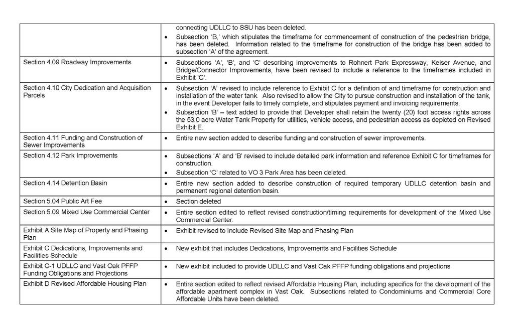
37 DA Comparison table
38 DA Exhibit C

39 DA Exhibit C

40 DA Exhibit C

41 DA Exhibit C-1
CITY OF ROHNERT PARK CITY COUNCIL AGENDA REPORT
 Mission Statement We Care for Our Residents by Working Together to Build a Better Community for Today and Tomorrow. CITY OF ROHNERT PARK CITY COUNCIL AGENDA REPORT ITEM NO. 8 Meeting Date: April 8, 2014
CITY OF ROHNERT PARK CITY COUNCIL AGENDA REPORT
 Mission Statement We Care for Our Residents by Working Together to Build a Better Community for Today and Tomorrow. CITY OF ROHNERT PARK CITY COUNCIL AGENDA REPORT ITEM NO. 12 Meeting Date: February 14,
Butte County General Plan 2030 General Plan Amendment and Draft Zoning Ordinance
 Butte County General Plan 2030 General Plan Amendment and Draft Zoning Ordinance Notice of Preparation Public Scoping Meeting Supplemental Environmental Impact Report (State Clearinghouse # 2012022059)
SUBJECT: CONSIDERATION OF CENTRAL PARK VILLAGE BREA ENTITLEMENT DOCUMENTS FOR A PROPOSED MIXED USE PROJECT AT W.
 City of Brea Agenda Item: 18 COUNCIL COMMUNICATION Date: July 17, 2012 TO: FROM: Honorable Mayor and City Council City Manager SUBJECT: CONSIDERATION OF CENTRAL PARK VILLAGE BREA ENTITLEMENT DOCUMENTS
CITY OF ELK GROVE CITY COUNCIL STAFF REPORT
 CITY OF ELK GROVE CITY COUNCIL STAFF REPORT AGENDA ITEM NO. 9.1 AGENDA TITLE: A public hearing to consider a Large Lot Tentative Subdivision Map, Small Lot Tentative Subdivision Map, Design Review for
Planning Commission Staff Report July 6, 2017
 Planning Commission Staff Report July 6, 2017 PROJECT: Bruceville Meadows FILE: EG-15-029 REQUEST: Community Plan Amendment, Special Planning Area Amendment, Large Lot Tentative Subdivision Map, Small
After taking public testimony, staff recommends the City Council take the following course of action:
 City Council Agenda May 5, 2015 Public Hearings Agenda Item No. B.04 Reviewed by City Mgr s office: /KLM Memo to: From: Manteca City Council Erika E. Durrer, Senior Planner Date: April 22, 2015 Subject:
Agenda Item No. 6B May 9, Honorable Mayor and City Council Attention: Jeremy Craig, Interim City Manager
 Agenda Item No. 6B May 9, 2017 TO: FROM: SUBJECT: Honorable Mayor and City Council Attention: Jeremy Craig, Interim City Manager Barton Brierley, AICP, Community Development Director (Staff Contact: Barton
NOTICE OF PREPARATION of a Draft Program Environmental Impact Report for the Fresno County General Plan Review and Zoning Ordinance Update
 NOTICE OF PREPARATION of a Draft Program Environmental Impact Report for the Fresno County General Plan Review and Zoning Ordinance Update Date: March 21, 2018 To: State Clearinghouse, Responsible Agencies,
CITY OF ROHNERT PARK CITY COUNCIL AGENDA REPORT
 Mission Statement We Care for Our Residents by Working Together to Build a Better Community for Today and Tomorrow. CITY OF ROHNERT PARK CITY COUNCIL AGENDA REPORT ITEM NO. 5.B.6 Meeting Date: March 26,
Butte County Board of Supervisors
 Butte County Board of Supervisors PUBLIC HEARING January 12, 2016 Amendments to the General Plan and Zoning Ordinance AG-P5.3 (Agricultural Buffer) and Interim Agricultural Uses Butte County Department
Town of Cary, North Carolina Rezoning Staff Report 14-REZ-31 Cary Park PDD Amendment (Waterford II) Town Council Meeting January 15, 2015
 Town Council Meeting January 15, 2015") Town of Cary, North Carolina Rezoning Staff Report 14-REZ-31 Cary Park PDD Amendment (Waterford II) Town Council Meeting January 15, 2015 REQUEST To amend the Town of Cary Official Zoning Map by amending
Town of Cary, North Carolina Rezoning Staff Report 14-REZ-31 Cary Park PDD Amendment (Waterford II) Town Council Meeting January 15, 2015 REQUEST To amend the Town of Cary Official Zoning Map by amending
RESOLUTION NO
 RESOLUTION NO. 2014- A RESOLUTION OF THE BOARD OF SUPERVISORS OF THE COUNTY OF NAPA, STATE OF CALIFORNIA, ADOPTING CEQA FINDINGS FOR ADOPTION OF THE DEVELOPMENT PLAN, DESIGN GUIDELINES, DEVELOPMENT AGREEMENT
Planning Commission Staff Report October 6, 2011
 Planning Commission Staff Report October 6, 2011 Project: Laguna Ridge Phase 3 Subdivision Projects McGeary Ranch, Arbor Ranch, Zgraggen Ranch & Tuscan Ridge Files: EG-10-059 (McGeary Ranch), EG-10-060
Planning Commission Staff Report July 16, 2015
 Staff Recommendation Planning Commission Staff Report July 16, 2015 Project: File: Request: PROPERTY OWNER: Souza Dairy Limited Partnership P.O. Box 637 Elk Grove CA 95759 Souza Dairy EG-13-030 Development
TOWN OF ORO VALLEY PLANNING & ZONING COMMISSION MEETING DATE: December 6, 2011
 PLANNING & ZONING COMMISSION MEETING DATE: December 6, 2011 TO: FROM: SUBJECT: PLANNING & ZONING COMMISSION Matt Michels, Senior Planner mmichels@orovalleyaz.gov; tel. 229-4822 Public Hearing: Rancho de
PLANNING COMMISSION AGENDA REPORT ADDENDUM AUGUST 14, Members of the Planning Commission
 PLANNING COMMISSION AGENDA REPORT ADDENDUM AUGUST 14, 2008 TO: FROM: Members of the Planning Commission Maureen Tamuri, Community Development Director Tom Bartlett, AICP, City Planner Glenn Michitsch,
Appendix J - Planned Unit Development (PUD)
") Appendix J - Planned Unit Development (PUD) Intent and Purpose The purpose of the PUD is: 1. To provide development that is consistent with the Comprehensive Land Use Plan and promote the goals and objectives
Appendix J - Planned Unit Development (PUD) Intent and Purpose The purpose of the PUD is: 1. To provide development that is consistent with the Comprehensive Land Use Plan and promote the goals and objectives
COUNTY OF ALBEMARLE PLANNING STAFF REPORT SUMMARY
 COUNTY OF ALBEMARLE PLANNING STAFF REPORT SUMMARY Project Name: ZMA 2010-00015, Cedar Hill Planning Commission Worksession: February 15, 2011 Public Hearing: Not scheduled Staff: Judith C. Wiegand, AICP
The following is a summary of the proposed policies and maps considered for analysis or amendments to the General Plan:
 NOTICE OF PREPARATION OF A DRAFT PROGRAM ENVIRONMENTAL IMPACT REPORT (EIR) AND NOTICE OF PUBLIC SCOPING MEETING FOR THE EL DORADO COUNTY TARGETED GENERAL PLAN AMENDMENT AND ZONING ORDINANCE UPDATE Location:
FULL TEXT OF MEASURE I CITY OF YORBA LINDA
 FULL TEXT OF MEASURE I CITY OF YORBA LINDA ORDINANCE NO. 2011-962 AN ORDINANCE OF THE CITY COUNCIL OF THE CITY OF YORBA LINDA ADOPTING THE YORBA LINDA TOWN CENTER SPECIFIC PLAN AND AN AMENDMENT TO THE
EMERYVILLE PLANNING COMMISSION. Report Date: June 18, 2015 Meeting Date: June 25, 2015
 EMERYVILLE PLANNING COMMISSION STAFF REPORT Report Date: June 18, 2015 Meeting Date: June 25, 2015 TO: Emeryville Planning Commission FROM: SUBJECT: LOCATION: APPLICANT: Michael Biddle, City Attorney City
MUNICIPALITY OF ANCHORAGE PLANNING AND ZONING COMMISSION RESOLUTION NO
 MUNICIPALITY OF ANCHORAGE PLANNING AND ZONING COMMISSION RESOLUTION NO. 0-07 A RESOLUTION SUPPORTING THE APPROVAL AND ADOPTION OF THE ANCHORAGE WETLANDS MANAGEMENT PLAN. (Case 0-09) WHEREAS, the Anchorage
PLANNING & ZONING COMMISSION RESOLUTION A RESOLUTION OF THE PLANNING COMMISSION OF THE CITY OF ALBANY, COUNTY
 PLANNING & ZONING COMMISSION RESOLUTION 0-0 A RESOLUTION OF THE PLANNING COMMISSION OF THE CITY OF ALBANY, COUNTY OF ALAMEDA, STATE OF CALIFORNIA, APPROVING A TENTATIVE PARCEL MAP TO CREATE A PARCEL AT
REPORT Elections Code 9212 Report on Proposed Initiative
 REPORT Elections Code 9212 Report on Proposed Initiative Initiative adopting the Vallco Town Center Specific Plan to (1) provide that the Vallco Shopping District Special Area ("Area") contains a mixture
CITY OF SANTA ROSA COMMUNITY DEVELOPMENT DEPARTMENT STAFF REPORT FOR PLANNING COMMISSION SEPTEMBER 10, 2015 APPLICANT FILE NUMBER MJP
 ITEM NO. 9 CITY OF SANTA ROSA COMMUNITY DEVELOPMENT DEPARTMENT STAFF REPORT FOR PLANNING COMMISSION SEPTEMBER 10, 2015 PROJECT TITLE Yogurt Time Center ADDRESS/LOCATION 3093 Marlow Road ASSESSOR S PARCEL
CITY OF ELK GROVE CITY COUNCIL STAFF REPORT
 AGENDA ITEM NO. 9.2 CITY OF ELK GROVE CITY COUNCIL STAFF REPORT AGENDA TITLE: A public hearing to consider a Specific Plan Amendment to the Laguna Ridge Specific Plan and a Rezone of approximately 4.14
REPORT TO THE CITY COUNCIL
 REPORT TO THE CITY COUNCIL DATE: Regular Meeting of January 13, 2015 TO: SUBMITTED BY: Mayor and Members of the City Council Holly Smyth, Planning Director SUBJECT: SYCAMORE CROSSING consisting of CEQA
Town of Cary, North Carolina Rezoning Staff Report 14-REZ-24 Indian Wells Road Properties Town Council Meeting November 20, 2014
 Town of Cary, North Carolina Rezoning Staff Report 14-REZ-24 Indian Wells Road Properties Town Council Meeting November 20, 2014 REQUEST To amend the Town of Cary Official Zoning Map by revising a condition
October 10, All Interested Parties
 TO: RE: All Interested Parties Addendum to the Final and Supplemental Environmental Impact Statements for the Pierce County Development Regulations. Amendments are proposed in Title 2 Administration, Construction
SAN JOSE CAPITAL OF SILICON VALLEY
 CITY OF C YA SAN JOSE CAPITAL OF SILICON VALLEY TO: HONORABLE MAYOR AND CITY COUNCIL SUBJECT: SEE BELOW COUNCIL AGENDA: 04/19/16 ITEM: il.tcb') Memorandum FROM: Planning Commission DATE: March 28, 2016
CITY OF RIO VISTA PLANNING COMMISSION STAFF REPORT
 MEETING DATE: January10, 2018 CITY OF RIO VISTA PLANNING COMMISSION STAFF REPORT AGENDA ITEM #4.2 PREPARED BY: Lamont Thompson, Planning Manager SUBJECT: Vesting Tentative Tract No. 2017-001: To consider
Honorable Mayor and Members of the City Council. Submitted by: Dan Marks, Director, Planning and Development
 Office of the City Manager WORKSESSION June 14, 2011 To: From: Honorable Mayor and Members of the City Council Phil Kamlarz, City Manager Submitted by: Dan Marks, Director, Planning and Development Subject:
Chair Brittingham, Vice-Chair Barron, Commissioner Hurt, Commissioner Keith, Commissioner LaRock
 City of Calimesa SPECIAL MEETING OF THE PLANNING COMMISSION AGENDA Monday, March 27, 2017 6:00 P.M. Norton Younglove Multi-Purpose Senior Center 908 Park Avenue, Calimesa, CA 92320 In compliance with the
CITY OF ELK GROVE PLANNING COMMISSION NOTICE OF CONTINUED PUBLIC HEARING
 Development Services - Planning 8401 Laguna Palms Way Elk Grove, California 95758 Tel: 916.478.2265 Fax: 916.691.3175 www.elkgrovecity.org CITY OF ELK GROVE PLANNING COMMISSION NOTICE OF CONTINUED PUBLIC
PART 1: PROJECT SUMMARY
 PART 1: PROJECT SUMMARY R18-04: Walden Major Revision Staff Analysis Petition R18-04 Walden Conditional District Rezoning Revision to revise Phases 3, 6, & 8 and add 6.16-acres of land (new Phase 9). Applicant:
4.2 LAND USE INTRODUCTION
 4.2 LAND USE INTRODUCTION This section of the EIR addresses potential impacts from the Fresno County General Plan Update on land use in two general areas: land use compatibility and plan consistency. Under
PRIMUS TRACT MOUNT PLEASANT, SOUTH CAROLINA
 DEVELOPMENT GUIDELINES FOR PRIMUS TRACT MOUNT PLEASANT, SOUTH CAROLINA Date February 18, 2015 PLANNING COMMISSION SUBMITTAL Owner/Developer: American Star Development SC, LLC P.O. Box 211 Sullivans Island,
Planning Commission Staff Report
 Planning Commission Staff Report January 5, 2017 PROJECT: Fieldstone North Tentative Subdivision Map Extension FILE: EG-13-004B REQUEST: Tentative Subdivision Map Extension LOCATION: Grantline Road at
COUNTY OF EL DORADO DEVELOPMENT SERVICES PLANNING COMMISSION STAFF REPORT TENTATIVE MAP
 COUNTY OF EL DORADO DEVELOPMENT SERVICES PLANNING COMMISSION STAFF REPORT Agenda of: June 27, 2013 Item No.: 9.a Staff: Mel Pabalinas TENTATIVE MAP FILE NUMBER: APPLICANT: REQUEST: LOCATION: TM10-1501/West
Watertown City Council
 City of Watertown Watertown City Council 2/14/2017 Agenda Item: Riverpointe Subdivision 2 nd Replat Request for Action: Sketch Plan Department: Planning Request for Action Request: Paxmar, LLC (Applicant)
REPORT OF THE PLANNING AND DEVELOPMENT DEPARTMENT FOR APPLICATION FOR REZONING ORDINANCE TO PLANNED UNIT DEVELOPMENT APRIL 21, 2016
 BEL REPORT OF THE PLANNING AND DEVELOPMENT DEPARTMENT FOR APPLICATION FOR REZONING ORDINANCE TO PLANNED UNIT DEVELOPMENT APRIL 21, 2016 The Planning and Development Department hereby forwards to the Planning
Rosslyn Sector Plan Implementation GLUP, MTP & Zoning Amendments. Park and Recreation Commission June 28, 2016
 Rosslyn Sector Plan Implementation GLUP, MTP & Zoning Amendments Park and Recreation Commission June 28, 2016 Agenda Background GLUP Amendments MTP Amendments Zoning Ordinance Amendments to the C-O Rosslyn
ARLINGTON COUNTY, VIRGINIA
 ARLINGTON COUNTY, VIRGINIA County Board Agenda Item Meeting December 9, 2006 DATE: November 20, 2006 SUBJECT: GP-302-05-2 Adoption of General Land Use Plan Amendments for the Clarendon Metro Station Area:
PLANNING COMMISSION STAFF REPORT June 18, 2015
 Community Development Department Planning Division 1600 First Street + P.O. Box 660 Napa, CA 94559-0660 (707) 257-9530 PLANNING COMMISSION STAFF REPORT June 18, 2015 AGENDA ITEM 7.B. PL15-0052 PM, GASSER
Town of Cary, North Carolina Rezoning Staff Report 12-REZ-27 Morris Branch Town Council Public Hearing January 24, 2013
 Town of Cary, North Carolina Rezoning Staff Report 12-REZ-27 Morris Branch Town Council Public Hearing January 24, 2013 REQUEST To amend the Town of Cary Official Zoning Map to rezone approximately 9.0
EXHIBIT D. WRITTEN DESCRIPTION For. TOWNSEND VILLAGE PUD December 23, 2015 (Revised)
") I. PROJECT DESCRIPTION EXHIBIT D WRITTEN DESCRIPTION For TOWNSEND VILLAGE PUD December 23, 2015 (Revised) A. This 7.2 acre single-family residential project is located on the East side of Townsend Boulevard,
I. PROJECT DESCRIPTION EXHIBIT D WRITTEN DESCRIPTION For TOWNSEND VILLAGE PUD December 23, 2015 (Revised) A. This 7.2 acre single-family residential project is located on the East side of Townsend Boulevard,
ADMINISTRATIVE STAFF REPORT 5.1
 ADMINISTRATIVE STAFF REPORT 5.1 DATE: January 24, 2017 ITEM: RECOMMENDATION: NOTIFICATION: PROPOSAL: DEV16-0014 - Danville Office Partners, LLC Approve Final Development Plan request DEV16-0014 subject
Contra Costa County Department of Conservation & Development
 Contra Costa County Department of Conservation & Development PANTAGES BAYS COUNTY FILES: GP#99-0008, RZ#04-3146, SD#06-9010, DP#04-3062 BOARD OF SUPERVISORS PUBLIC HEARING DECEMBER 3, 2013 1 SITE LOCATION
Jefferson County. Case RZ. Presenter: Alan Tiefenbach. Planning and Zoning Division
 Green Gables Official Development Plan Case 11-119319RZ Presenter: Alan Tiefenbach Proposal Rezone from Agricultural-Two (A-2) to Planned Development (PD) 225,000 square feet of commercial uses, including
STAFF REPORT. Permit Number: Unlimited. Kitsap County Board of Commissioners; Kitsap County Planning Commission
 STAFF REPORT Permit Number: 15 00550 Unlimited DATE: March 2, 2016 TO: FROM: Kitsap County Board of Commissioners; Kitsap County Planning Commission Katrina Knutson, AICP, Senior Planner, DCD and Jeff
Planning Commission Application Summary
 Planning Commission Application Summary Project Name: Creekside Estates Zone Change and Land Use Amendment Address: 571 West 11400 South Current Zoning: RA1 Hearing Date: July 14, 2016 Summary of Request
AN ORDINANCE OF THE NAPA COUNTY BOARD OF SUPERVISORS, APPROVING THE DEVELOPMENT AGREEMENT BETWEEN NAPA COUNTY AND NAPA REDEVELOPMENT PARTNERS, LLC
 ORDINANCE NO. AN ORDINANCE OF THE NAPA COUNTY BOARD OF SUPERVISORS, APPROVING THE DEVELOPMENT AGREEMENT BETWEEN NAPA COUNTY AND NAPA REDEVELOPMENT PARTNERS, LLC WHEREAS, to strengthen the public planning
REZONING STAFF REPORT Case: Jay Sikes, Mgr. of Planning Services Phone: (910) Fax: (910)
 Fax: (910)") REZONING Case: 15-67 Jay Sikes, Mgr. of Planning Services jsikes@harnett.org Phone: (910) 893-7525 Fax: (910) 814-8278 Planning Board: April 6, 2015 County Commissioners: April 20, 2015 Requesting a Rezoning
REZONING Case: 15-67 Jay Sikes, Mgr. of Planning Services jsikes@harnett.org Phone: (910) 893-7525 Fax: (910) 814-8278 Planning Board: April 6, 2015 County Commissioners: April 20, 2015 Requesting a Rezoning
2018 RESIDENTIAL CAPACITY AND VACANT LAND ANALYSIS. Martin County Board of County Commissioners
 2018 RESIDENTIAL CAPACITY AND VACANT LAND ANALYSIS Martin County Board of County Commissioners Approved February 13, 2018 INTRODUCTION Objective 4.1D of the Martin County Comprehensive Growth Management
Prepared by: Casey Kempenaar, Senior Planner
 CITY OF CITRUS HEIGHTS PLANNING DIVISION STAFF REPORT PLANNING COMMISSION MEETING September 13, 2017 Prepared by: Casey Kempenaar, Senior Planner REQUEST The applicant requests approval of a Tentative
Z O N I N G A DJUSTMENTS B O A R D
 Z O N I N G A DJUSTMENTS B O A R D S t a f f R e p o r t FOR BOARD ACTION NOVEMBER 8, 2018 59 The Plaza Drive Use Permit #ZP2018-0164 to alter an existing three-story, 6,520 square-foot, single-family
LEMOORE PLANNING COMMISSION Regular Meeting AGENDA Lemoore Council Chamber 429 C Street. May 14, :00 p.m.
 LEMOORE PLANNING COMMISSION Regular Meeting AGENDA Lemoore Council Chamber 429 C Street May 14, 2018 7:00 p.m. 1. Pledge of Allegiance 2. Call to Order and Roll Call 3. Public Comment This time is reserved
1.0 INTRODUCTION 1.1 OVERVIEW
 .0 INTRODUCTION 0 0 0. OVERVIEW The County of Santa Barbara prepared a Draft Environmental Impact Report (EIR) for the Paradiso del Mare Ocean Estates and Inland Estates Project and circulated the Draft
ORDINANCE NO. XXXX. WHEREAS, the proposed Rezone has been processed pursuant to Section , Title 9 of the Municipal Code; and
 ORDINANCE NO. XXXX AN ORDINANCE OF THE CITY COUNCIL OF THE CITY OF SAN JUAN CAPISTRANO, CALIFORNIA, ADOPTING AN ADDENDUM TO THE MITIGATED NEGATIVE DECLARATION ADOPTED FOR THE 2014-2021 GENERAL PLAN HOUSING
CITY OF ELK GROVE CITY COUNCIL STAFF REPORT
 CITY OF ELK GROVE CITY COUNCIL STAFF REPORT AGENDA ITEM NO. 9.3 AGENDA TITLE: A public hearing to consider a General Plan Amendment, Specific Plan Amendment, Rezone, Tentative Subdivision Map, Abandonment
PLANNING AND ZONING COMMISSION AGENDA MEMORANDUM
 City and County of Broomfield, Colorado PLANNING AND ZONING COMMISSION AGENDA MEMORANDUM To: Planning and Zoning Commission From: John Hilgers, Planning Director Anna Bertanzetti, Principal Planner Meeting
Comment: the Plan endeavors to conserve resources that can nurture additional development. What kind of resources, environmental, capital, or etc.?
 Memorandum TO: Peggy Fiandaca and Curt Dunham, Partners for Strategic Action Inc. FROM: Jessica Sarkissian, CMX DATE: September 4, 2008 SUBJECT: Proposed 2008 Draft Comprehensive Plan Comments This memo
PLANNING COMMISSION OCTOBER 19, 2017 PUBLIC HEARING
 PLANNING COMMISSION OCTOBER 19, 2017 PUBLIC HEARING SUBJECT: ZONE TEXT AMENDMENT AND ZONE MAP AMENDMENT IMPLEMENTING R3C-C ZONING DISTRICT IDENTIFIED IN THE WEST HOLLYWOOD GENERAL PLAN 2035 AND ANALYSIS
ORDINANCE NO. THE CITY COUNCIL OF THE CITY OF SANTA CLARITA, CALIFORNIA, DOES HEREBY ORDAIN AS FOLLOWS:
 ORDINANCE NO. AN ORDINANCE OF THE CITY COUNCIL OF THE CITY OF SANTA CLARITA, CALIFORNIA, CHANGING THE ZONING DESIGNATION OF THE HENRY MAYO NEWHALL HOSPITAL CAMPUS FROM PUBLIC/INSTITUTIONAL TO SPECIFIC
Section 1: US 19 Overlay District
 Section 1: US 19 Overlay District Section 1.1 Intent and Purpose The purpose of the US Highway 19 Overlay District is to manage access to land development along US Highway 19 in a manner that preserves
CHAPTER IV IMPLEMENTATION
 CHAPTER IV IMPLEMENTATION Chapter Outline IV. Implementation Page A. Public Works Projects/Public Infrastructure IV-1 1. Facilities Master Plan Overview IV-1 2. Facilities Master Plan Service Standards
CITY OF ELK GROVE CITY COUNCIL STAFF REPORT
 CITY OF ELK GROVE CITY COUNCIL STAFF REPORT AGENDA ITEM NO. 8.6 AGENDA TITLE: Adopt resolution authorizing the City Manager to execute an Agreement for Acquisition of Fee Interest, Pedestrian and Utility
CASE SUMMARY Conditional District Zoning Modification Planning Commission January 9, 2013 CD M1212
 CASE SUMMARY Conditional District Zoning Modification Planning Commission January 9, 2013 CD-3-109-M1212 Jim Diepenbrock, Associate Planner jim.diepenbrock@wilmingtonnc.gov 910-341-3257 Staff recommendation
Sacramento Railyards P December 11, 2007
 Sacramento Railyards P05-097 December 11, 2007 Richards Boulevard Area Plan and Facility Element to address the 5 th and 7 th Street Operations 22) a City Resolution approving Business Terms for Sacramento
City of Cupertino AB 1600 Mitigation Fee Act Annual & Five Year Report for the fiscal years ending June 30, 2014 & 2015
 City of Cupertino AB 1600 Mitigation Fee Act Annual & Five Report for the fiscal years ending June 30, 2014 & 2015 Dept.: Community Development : Below Market Rate (BMR) Housing Mitigation Fee Local Authority:
Agenda Report TO: CITY COUNCIL DATE: NOVEMBER 20,2006
 Agenda Report TO: CITY COUNCIL DATE: NOVEMBER 20,2006 FROM: CITY MANAGER SUBJECT: FULLER THEOLOGICAL SEMINARY MASTER DEVELOPMENT PLAN, FINAL ENVIRONMENTAL IMPACT REPORT, AND DEVELOPMENT AGREEMENT RECOMMENDATION
3.0 Project Description
 3.0 Project Description City of Long Beach Shoreline Gateway Project Environmental Impact Report 3.0 PROJECT DESCRIPTION 3.1 PROJECT LOCATION AND SETTING PROJECT LOCATION The proposed Shoreline Gateway
FORA Board Consistency Determinations Summary
 FORA Board Consistency Determinations Summary BOARD ACTION SUMMARIES Occurance (mm/dd/yy) Summary 1997 Approved Consistency of Marina Municipal Airport Redevelopment Plan: 2nd Finding of Consistency with
Claudia Stuart, Williamson Act Program Manager and Nick Hernandez, Planning Intern
 Land Conservation (Williamson) Act Advisory Committee STAFF REPORT September 15, 2014 Prepared by: Claudia Stuart, Williamson Act Program Manager and Nick Hernandez, Planning Intern Subject: Discussion:
4.1 Overview. 4.2 Land Use Plan
 4.1 Overview The Sierra Vista Specific Plan provides for a mix of land uses to achieve the desired community form and Plan Area objectives. These land use designations include low-, medium-, and high-density
PLANNING COMMISSION STAFF REPORT February 19, 2015
 Community Development Department Planning Division 1600 First Street + P.O. Box 660 Napa, CA 94559-0660 (707) 257-9530 PLANNING COMMISSION STAFF REPORT February 19, 2015 AGENDA ITEM #7A PL13-0091 GENERAL
Town of Falmouth s Four Step Design Process for Subdivisions in the Resource Conservation Zoning Overlay District
 Town of Falmouth s Four Step Design Process for Subdivisions in the Resource Conservation Zoning Overlay District All subdivisions shall be designed in accordance with the following four-step process.
PLANNING COMMISSION MAY 3, 2018 PUBLIC HEARING
 PLANNING COMMISSION MAY 3, 2018 PUBLIC HEARING SUBJECT: REQUEST TO DEMOLISH TWO SINGLE-FAMILY DWELLINGS ON TWO ADJOINING LOTS AND CONSTRUCT TEN RESIDENTIAL CONDOMINIUM UNITS AT 947 GENESEE AVENUE AND 944
Public Hearing. Item # 16. Meeting Date: June 3, 2014
 Item # 16 Meeting Date: June 3, 2014 Public Hearing Ordinance No. 2014-18: An Ordinance Amending the Town s Zone District Map by Approving the Plum Creek Ridge Planned Development Plan Amendment No. 1
Planning Commission Staff Report August 4, 2016
 Planning Commission Staff Report PROJECT: Ermandarold Estates TSM Extension FILE: EG-07-128A REQUEST: Tentative Subdivision Map Extension LOCATION: 8577 Bader Road APN: 122-0230-001, 003, 004, 005, 006
1999 Town Center West Proposal
 Crescent Square June 10, 2014 Page 2 1999 Town Center West Proposal Food-4- Less Retail Not a Part On June 10, 2004, the City Council and Planning Commission conducted a joint workshop to review conceptual
STAFF REPORT. To: Planning Commission Meeting date: February 8, 2017 Item: ZN Prepared by: Johanna Murphy
 # 7 ) ZN-04-17 VILLAGES AT TULE SPRINGS, VILLAGE 3 PCD, PLANNED COMMUNITY DISTRICT TO R-CL / PCD; MEDIUM DENSITY RESIDENTIAL / PLANNED COMMUNITY DISTRICT PUBLIC HEARING STAFF REPORT To: Planning Commission
Town of Cary, North Carolina Rezoning Staff Report 14-REZ-02 Cary Oaks Subdivision Town Council Meeting June 12, 2014
 Town of Cary, North Carolina Rezoning Staff Report 14-REZ-02 Cary Oaks Subdivision Town Council Meeting June 12, 2014 REQUEST To Amend the Town of Cary Official Zoning Map to apply initial Cary zoning
LINCOLN COUNTY PLANNING & INSPECTIONS DEPARTMENT
 To: Board of Commissioners From: Randy Hawkins, Zoning Administrator Date: August 4, 2015 Re: Planning Board recommendations (08/03/15) UDO Proposed Amendments #2015-3 Lincoln County Planning and Inspections
Approval of Takoma Amended Joint Development Agreement and Compact Public Hearing
 Planning, Program Development and Real Estate Committee Item IV - B March 13, 2014 Approval of Takoma Amended Joint Development Agreement and Compact Public Hearing Washington Metropolitan Area Transit
Coastal Apartment Homes 2250 E. Pleasant Valley Rd
 Coastal Apartment Homes 2250 E. Pleasant Valley Rd PZ No. 14-540-01 Special Use Permit (SUP) for a Planned Development (PD) PZ No. 14-535-01 Density Bonus (DB) PZ No. 14-570-02 Zone Change (ZC) MND No.
LAND USE ELEMENT CITY OF HAWTHORNE GENERAL PLAN
 LAND USE ELEMENT CITY OF HAWTHORNE GENERAL PLAN Adopted April, 1990 Last amended March, 2016 Prepared by: Cotton/Beland/Associates, Inc. 1028 North Lake Avenue, Suite 107 Pasadena, California 91104 TABLE
DRAFT Subject to Modifications
 TREASURE COAST REGIONAL PLANNING COUNCIL M E M O R A N D U M DRAFT Subject to Modifications To: Council Members AGENDA ITEM 5L From: Date: Subject: Staff September 17, 2010 Council Meeting Local Government
Central Lathrop Specific Plan
 Addendum to the Draft Environmental Impact Report for the Central Lathrop Specific Plan SCH# 2003072132 Prepared for City of Lathrop Prepared by December 2005 Addendum to the Draft Environmental Impact
Planning & Zoning Commission
 Planning & Zoning Commission Planning & Development Department August 14, 01 Zoning Map Amendment MAP-1-0001 (Bay View Section 4) Request Rezone approximately 1.19 acres from OS (Open Space) to RSF- (Residential
Planning Commission Staff Report October 2, 2014
 Commission Staff Report October 2, 2014 Project: Stathos Cove Request: Rezone and Tentative Subdivision Map File: EG-14-001 Location: North side of Elk Grove Boulevard, approximately 1,800 feet west of
CITY OF ELK GROVE CITY COUNCIL STAFF REPORT
 CITY OF ELK GROVE CITY COUNCIL STAFF REPORT AGENDA ITEM NO. 10.1 AGENDA TITLE: Consider adoption of a resolution finding no further review is required under the California Environmental Quality Act (CEQA)
County Council Of Howard County, Maryland
 County Council Of Howard County, Maryland 010 Legislative Session Legislative Day No. 7 Resolution No. 91-010 Introduced by: The Chairperson at the request of the County Executive A RESOLUTION pursuant
POLK COUNTY DEVELOPMENT REVIEW COMMITTEE CASE OVERVIEW
 POLK COUNTY DEVELOPMENT REVIEW COMMITTEE CASE OVERVIEW DRC Date: January 10, 2019 Level of Review: 4 PC Date: March 6, 2019 Type: Text Amendments BoCC Date: May 7, 2019 July 2, 2019 Case Numbers: Case
Town of Cary, North Carolina Rezoning Staff Report 13-REZ-31 Weston PDD Amendment at Centregreen Park Town Council Meeting March 13, 2014
 Town of Cary, North Carolina Rezoning Staff Report 13-REZ-31 Weston PDD Amendment at Centregreen Park Town Council Meeting March 13, 2014 REQUEST This proposed amendment to the Town of Cary Official Zoning
Memorandum TO: HONORABLE MAYOR AND CITY COUNCIL. FROM: Planning Commission. DATE: September 28, 2015 SUBJECT: SEE BELOW COUNCIL DISTRICT: 3
 CITY OF 0% B: *2 SAN TOSE CAPITAL OF SILICON VALLEY TO: HONORABLE MAYOR AND CITY COUNCIL SUBJECT: SEE BELOW COUNCIL AGENDA: 10/20/15 ITEM: 11. I (a) Memorandum FROM: Planning Commission DATE: September
Technology Park Planned Unit Development Technology Park PUD-IP
 Technology Park Planned Unit Development Technology Park PUD-IP Rob Anderson Community Development Director Planned Unit Development Background 2 Planned Unit Development (PUD) means a mixed use redevelopment
ITEM 7-C. CITY OF ALAMEDA Memorandum. Honorable President and Members of the Planning Board. From: Andrew Thomas City Planner
 CITY OF ALAMEDA Memorandum ITEM 7-C To: Honorable President and Members of the Planning Board From: Andrew Thomas City Planner Jennifer Ott Chief Operating Officer Alameda Point Date: Re: Public Hearing
APPLICATIONS FOR OFFICIAL PLAN AMENDMENT AND ZONE CHANGE
 COMMUNITY AND STRATEGIC PLANNING P. O. Box 1614, Court House, Woodstock Ontario N4S 7Y3 Phone: 519-539-9800 Fax: 519-537-5513 Web Site: www.county.oxford.on.ca Our Files: OP 11-153 & ZON 3-07-18 APPLICATIONS