Planning Commission Staff Report July 6, 2017
|
|
|
- Philip Henry
- 5 years ago
- Views:
Transcription

1 Planning Commission Staff Report July 6, 2017 PROJECT: Bruceville Meadows FILE: EG REQUEST: Community Plan Amendment, Special Planning Area Amendment, Large Lot Tentative Subdivision Map, Small Lot Tentative Subdivision Map, Design Review for Subdivision Layout and Abandonment LOCATION: Northeast corner of Bruceville Rd. and Kammerer Rd. APN: , -007, -008, -009, -011, -013, and -046 STAFF: Darcy Goulart PROPERTY OWNERS: George W. & Ruth E. Seames Bruceville Road Elk Grove, CA Loren Kammerer, Kammerer Trust & Ruthie Cohen, Cohen Trust PO Box 727 Elk Grove, CA APPLICANT: Hackberry II, LLC Steve Gidaro 401 Watt Ave., Suite 4 Sacramento, CA Mike Simas, Simas Trust & Robert W. Kammerer Trust Murieta South Parkway Rancho Murieta, CA Tracy K. Ashorn 7710 Bilby Road Elk Grove, CA AGENT: Gillum Consulting Jim Gillum 1135 Amalgam way, No 9 Gold River, CA Staff Recommendation Staff recommends that the Planning Commission adopt a Resolution making a recommendation that the City Council: 1. Find the Project exempt from the California Environmental Quality Act (CEQA) pursuant to State CEQA Guidelines Section (Projects Consistent with a Community Plan, General Plan, or Zoning) and (Subsequent EIRs and Negative Declarations); and 2. Adopt a Resolution approving a Community Plan Amendment, Large Lot Tentative Subdivision Map, Small Lot Tentative Subdivision Map, Design Review for Subdivision Layout, and Abandonment subject to findings and conditions of approval; and. 3. Adopt an Ordinance approving a Special Planning Area Amendment to Section B.7 Southeast Policy Area SPA (Ordinance No ) for the Bruceville Meadows Project (EG ). Project Description The Bruceville Meadows Project includes: Community Plan and Special Planning Area Amendment for the Southeast Policy Area (SEPA) to reconfigure the boundaries and acreages of the existing land use designations to include an increase to the estate residential, increase the low density residential, and eliminate the medium density residential. The amendment also reflects a change to Chapter 4, Physical Street Forms: Streets, Page 4-5 of the SEPA document to change the

2 Elk Grove Planning Commission Bruceville Meadows EG July 6, 2017 Page 2 south to west collector street on the Project site from a collector to a primary residential street and the most current design work for the Shed C Channel and design for the S7 drainage basin. Large Lot Tentative Subdivision Map to create a total of 17 large area lots and provide for future phasing of the Project. Small Lot Tentative Subdivision Map, consisting of 332 residential lots at varying densities and 1 lot for future high-density residential, pocket park lots; and various drainage and detention basins, landscape, and parkway lots, collectively on approximately acres. Design Review for Subdivision Layout Abandonment of easements and/or rights-of-way as shown on the maps. Background On July 9, 2014, the City Council adopted the SEPA Strategic Plan, which included the certification of an Environmental Impact Report (EIR) and adoption of the SEPA Community Plan, SEPA Special Planning Area (SPA), and the various master plans for water, sewer, drainage, and traffic required for SEPA. SEPA is approximately 1,200 acres located in the southern portion of the City (Figure 1) and includes the entirety of the City s Southeast Policy Area, as designated in the General Plan. SEPA is generally bounded by Poppy Ridge Road, Kammerer Road, a future extension of Big Horn Boulevard, and another future major roadway to the east (Lotz Parkway), with a panhandle section that extends to the west along Kammerer Road (sometimes referred to as the west end ). The west end of SEPA is bounded by Kammerer Road to the south, Bruceville Road to the west, and Bilby Road to the north. SEPA has historically been used for agricultural purposes and is primarily undeveloped with some scattered residences, ornamental landscaping, and outbuildings. An irrigation channel, flowing in an east to-west direction, bisects the SEPA area. Figure 1: Southeast Policy Area Southeast Policy Area The SEPA land plan (Figure 2) establishes the overall land plan for subsequent developments within the SPA by establishing a range of land use designations, which function like mini-zoning

3 Elk Grove Planning Commission Bruceville Meadows EG July 6, 2017 Page 3 districts, subordinate to the larger SPA zoning. The SEPA land plan is not meant to be overlaid with existing parcel lines and does not indicate specific acreage requirements for specific land use types. The layout is inherently flexible and is meant to guide the final configuration of land uses through the approval of subsequent tentative maps. Figure 2: Southeast Policy Area Community Land Plan Bruceville Meadows Project The City is moving forward on some early implementation steps for SEPA. These include the following: Construction of the sewer lift station and force main to serve the area; Constructing the extension of Big Horn Boulevard from Whitelock Parkway to Bilby Road and Bilby Road from Bruceville Road to Big Horn Boulevard, which includes the inside two lanes and accompanying trunk infrastructure (e.g., water, sewer, electrical, natural gas, etc.) to serve the area; Pursuing environmental permitting for the Shed C Drainage Channel improvements; and Preparing fee programs covering drainage, parks, and trails. Analysis SEPA Community Plan and Special Planning Area Amendment The Applicant is requesting Community Plan and Special Planning Area Amendments to reconfigure the land use designations for the Project site. Figure 3 depicts the existing and proposed land use boundaries for the Project. Table 1 provides a comparison of the existing and proposed land use designations. As shown, there is a significant increase in estate residential housing, the elimination of medium-density residential acreage, and a slight increase in low density residential. The Applicant is proposing these changes to provide greater opportunities for an under-served segment of the housing market. Additionally, there have been previous indications from policy makers for a desire to see more estate residential housing opportunities.

4 Elk Grove Planning Commission Bruceville Meadows EG July 6, 2017 Page 4 In the early stages of drafting the SEPA document, the land plan contemplated a higher ratio of estate residential on the Project site. However, a previous land optionee had requested a lower ratio and the plan was adopted reflecting that request. The proposed changes are more in keeping with the original intent of the SEPA plan prior to the previous optionee s requested changes. Figure 3: Existing 1 and Proposed Land Use Boundaries Existing Proposed HDR MDR LDR ER DC Parkway PUOS/R DC Table 1: Land Use Summary Land Use Existing Acreage 1 Proposed Acreage Difference Estate Residential (ER) Low Density Residential (LDR) Medium Density Residential (MD) High Density Residential (HDR) Public Open Space/Recreation (PUOS/R) Parkway (Greenways) Drainage Channel (DC) Total AC AC 0.0 Notes: 1. Existing acreage information is approximate and in keeping with the land plan and development capacity information presented in the SEPA SPA (Chapter 2). 2. Includes detention basins. The SPA amendment also includes a change to Chapter 4 Physical Street Forms: Streets, Page 4-5 of the SEPA document to change the south to west collector street on the Project site from a collector to a primary residential street. Figure 4 depicts the existing and proposed street layout.

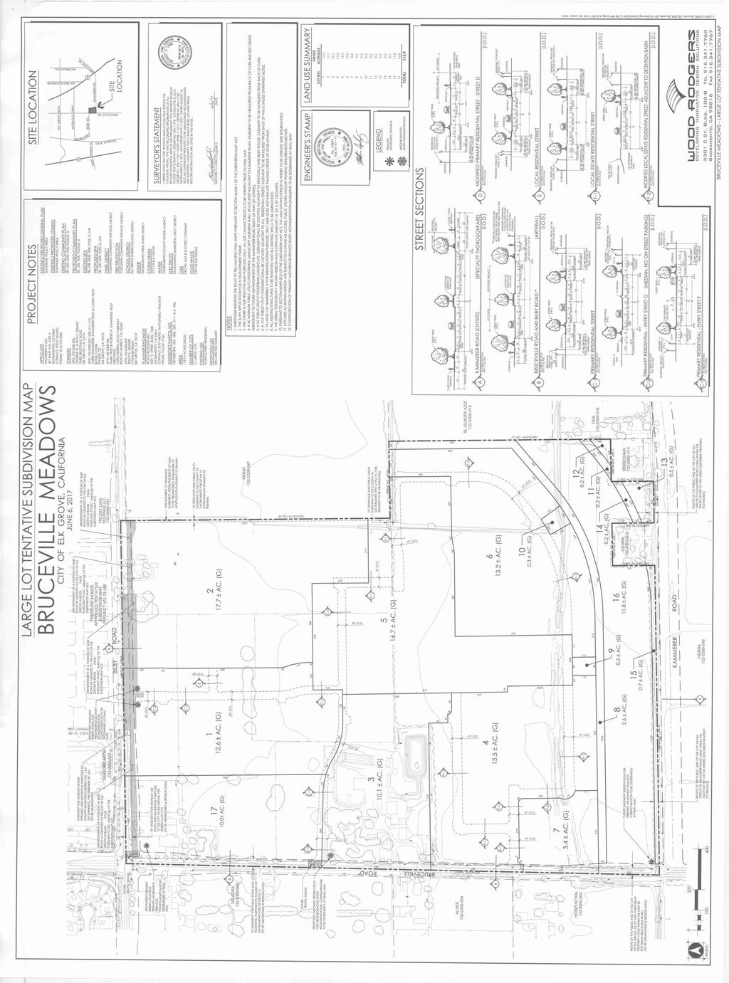
5 Elk Grove Planning Commission Bruceville Meadows EG July 6, 2017 Page 5 Figure 4: Physical Street Form Amendment Existing Proposed Tentative Subdivision Maps (Large and Small) and Design Review for Subdivision Layout The proposed Project includes both Large Lot and Small Lot Tentative Subdivision Maps. These proposed maps are consistent with the Elk Grove General Plan, the SEPA Community Plan and Special Planning Area (reflective of the amendments described above), and all applicable Municipal Code requirements and subdivision regulations as described in this report. The proposed Large Lot Tentative Subdivision Map (Figure 5) will create 17 large lots for phasing and financing.
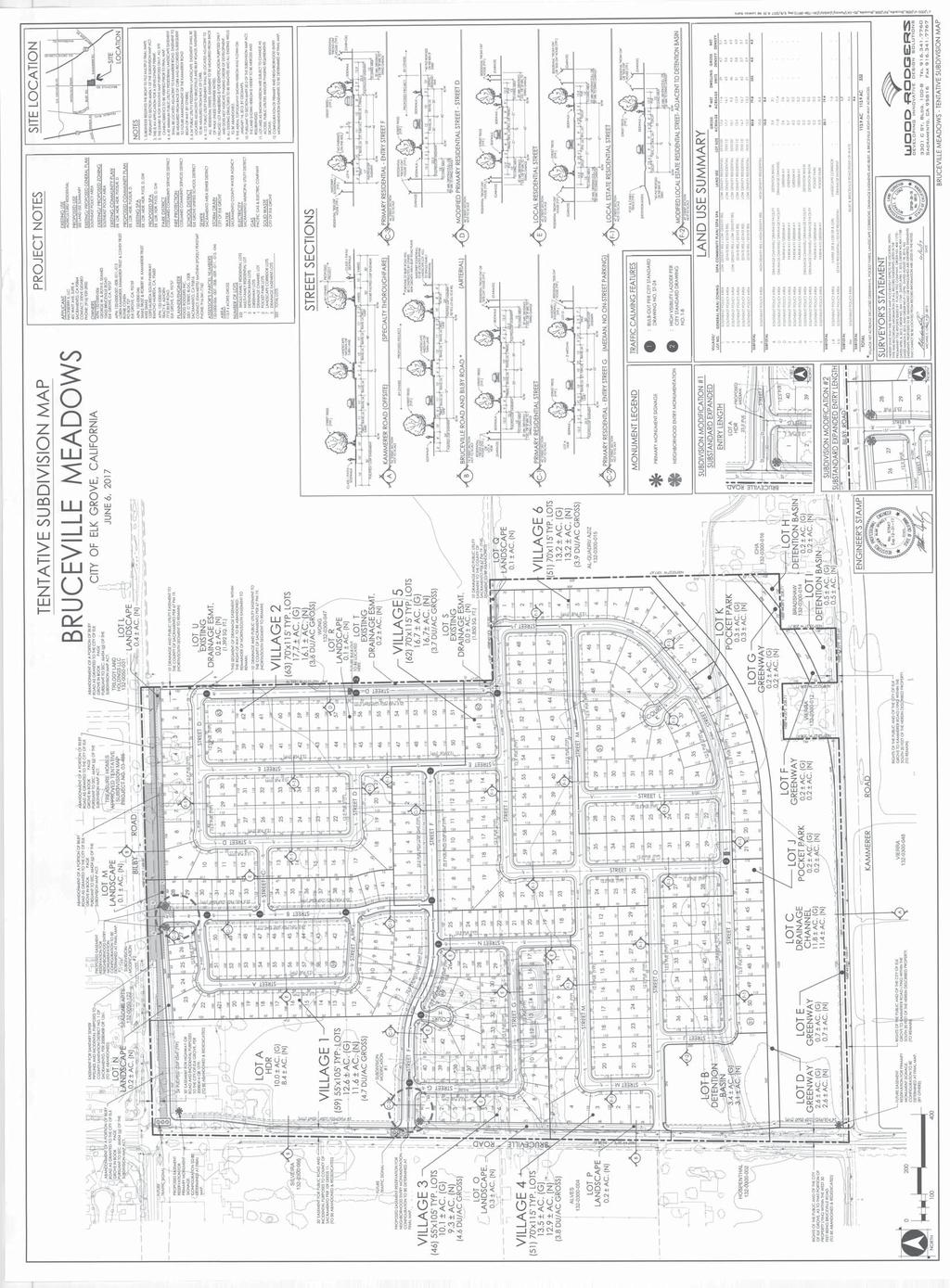
6 Elk Grove Planning Commission Bruceville Meadows EG July 6, 2017 Page 6 Figure 5: Large Lot Tentative Subdivision Map The Small Lot Tentative Subdivision Map, presented in Figure 6, will create the following: 332 Single Family Residential Lots within six (6) villages 1 High Density Residential Lot 2 Pocket Park Lots 4 Greenway Lots 7 Landscape Lots 4 Drainage Channel/Facility Lots
.")
7 Elk Grove Planning Commission Bruceville Meadows EG July 6, 2017 Page 7 Figure6: Small Lot Tentative Subdivision Map Access and Layout The Project site is bound by three roadways; Bilby Road to the north, Bruceville Road to the west and Kammerer Road to the south. The proposed Project layout and circulation is consistent with the design protocols of the SEPA SPA (Chapter 5, Section A). According to the SEPA SPA, the layout and circulation for new development shall be based upon a modified grid pattern. The layout of streets may include a mixture of grid, cul-de-sacs, or curvilinear alignments as long as the pattern is logical and comprehensible, minimizing circuitous routes. The SPA also requires connections and linkages to
8 Elk Grove Planning Commission Bruceville Meadows EG July 6, 2017 Page 8 the greenway system wherever possible. The street system has been laid out to provide connections to the greenways either through a paseo or pocket parks. Once completed, vehicular access through the residential areas of the site will be provided through three locations along major arterial roadways, including one entry on Bilby Road and two entries from Bruceville Road. The Bilby Road entrance will be limited to right-in/right-out movements. Of the two Bruceville Road entries, the northerly entrance (Street F) will be a signalized intersection. The southerly entrance (Street O) will allow right-in/right-out and left-in movements only. Street F will serve as the primary residential street for the Project, traversing the Project site in an east-west direction consistent with the SPA s Street Layout Map (SPA Chapter 4, Physical Form: Streets), providing access to the future high density residential lot as well as the low density and estate residential lots. Internal streets have been planned to achieve access throughout the various neighborhoods, making it possible to circulate through the Project without having to exit onto a major arterial. The street pattern design lends itself to lower travel speeds and discourages cut through traffic. This was a major issue for the Applicant and staff worked with them to ensure that the layout was consistent with the SPA while still meeting their objectives. To that end, consistent with the SPA, the Project provides for future connection to the east towards the future park and school sites on the adjoining Wong and Mendes properties. This connection will occur along Street D, located between proposed Lots 54 and 59. Abandonment The property owner previously dedicated right-of-way to the City to facilitate construction of infrastructure along Bilby Road, including extension of water, sewer, electrical, gas, and roadway. This will allow the City to construct interim and permanent improvements concurrently with development. Portions of this previously dedicated right-of-way are proposed to be abandoned (as shown on the map) and rededicated in the ultimate configuration. The interim, widerright-of-way area was necessary to support interim construction conditions, which the Applicant will address with their ultimate frontage improvements. The Project also proposes to abandon portions of the existing north-south 10 drainage easement adjacent to Street D and the sanitary sewer easement located within Bilby Road right-of-way as shown on the maps. Residential Land Uses The Project includes six (6) residential villages comprised of 332 residential lots (Table 1). The proposed lot sizes and densities are consistent with the requirements of the SEPA SPA. Of the 322 residential lots, 227 lots are designated as estate residential and 105 lots are low density residential. The estate residential lots average in size of about 8,050 sq. ft. The low density residential lots have an average size of 5,775 sq. ft. The Applicant provided a Land Use Exhibit which details the Residential Villages consistency with the SEPA Land Use Plan and includes applicable building forms for each Village (Table 2). Please note that subsequent building design will be reviewed and approved by the City through the subsequent master home plan design review process. The Project includes one large lot for future high-density residential (Large Lot 17). HDR Lot 14 is located in the northwest corner of the Project site and would be accessed from Bruceville Road and F Street. Future design review approval will be required for development on this site.
9 Elk Grove Planning Commission Bruceville Meadows EG July 6, 2017 Page 9 Village/ Lot Land Use Density Table 2: Single Family Residential Lot Type Lot Count Gross Acres Gross Density Applicable Building Forms (SEPA SPA Chapter 4) 1 LDR x105 typ I, J 2 ER x115 typ G 3 LDR x105 typ I, J 4 ER x115 typ G 5 ER x115 typ G 6 ER x115 typ G A HDR n/a S, T TOTAL Notes: 1. Required minimum density pursuant to the Housing Element of the General Plan. Trails/Greenways/Parks The Project includes 2.6 acres of greenways, which provides off-street access and connectivity to the pocket parks and Shed C Channel. The greenways are specifically located along the north and south side of the Shed C Channel, consistent with the SPA. Along Kammerer Road, the greenway also serves as the landscape corridor for the roadway, as shown in Street Section A. The Project includes two pocket park sites located in the southern area of the Project site. These sites and sizes are specifically identified in the SEPA SPA land plan. Larger park facilities, pursuant to the SPA, will occur off-site on the Wong and Mendes properties, which identify Local and Community Park sites, respectively. As described below, the pocket parks will link to the future off-site parks through trails/greenways. A paseo is provided between Lots 44/57 and 45/56 as mid-block access from the subdivision to the eastern property line. This connection will promote pedestrian activity from the subdivision to the future parks and school sites to the east. Drainage The Shed C Channel is located along the southern edge of the Project site, just north of Kammerer Road. The Shed C Channel is the conveyance facility for stormwater drainage through the SEPA area and other properties to the east. It will take flows from the various detention basins and convey them to the west to the Stone Lakes Wildlife Refuge. The Project includes one Project-serving basin (Lot B), as well as additional acreage for the basin serving the West Business Park (to the southeast of the Project site, Lots H and I). The Applicant is conditioned to build the basins and the Channel improvements to support the Project. Letters from Commenting Agencies The Project was routed to various City, County, and State agencies. Comments received were incorporated into Project design and the (Attachment 1, Exhibits C and D).
10 Elk Grove Planning Commission Bruceville Meadows EG July 6, 2017 Page 10 Environmental Analysis The California Environmental Quality Act (CEQA) requires analysis of agency approvals of discretionary Projects. A Project, under CEQA, is defined as the whole of an action, which has a potential for resulting in either a direct physical change in the environment, or a reasonably foreseeable indirect physical change in the environment. The proposed Project is a project under CEQA. The Project is exempt from the California Environmental Quality Act (CEQA) pursuant to Title 14 of the California Code of Regulations, (State CEQA Guidelines) Section (Projects Consistent with a Community Plan, General Plan, or Zoning). State CEQA Guidelines Section (Public Resources Code ), provides that projects that are consistent with a Community Plan, General Plan or Zoning for which an EIR has been certified shall not require additional environmental review, except as might be necessary to examine whether there are project-specific significant effects which are peculiar to the project or its site. On July 9, 2014, the City Council certified an EIR for the Southeast Policy Area Strategic Plan (State Clearinghouse No ). The SEPA EIR analyzed full buildout of SEPA based upon the land plan, development standards, and policies contained in the Community Plan and Special Planning Area, as well as the improvements identified in the accompanying infrastructure master plans. The Bruceville Meadows Project proposes changes to the Community Plan and Special Planning Area which reconfigures the boundaries and acreages of the existing land use designations to include an increase to the estate residential and low density residential, slight decrease of high density residential and elimination of the medium density residential. The changes also reflect the most current design work for the Shed C Channel and design for the S7 drainage basin. Although there is an increase in two residential land use categories, the elimination of 20.1 acres of medium density residential and slight decrease of the high density residential reduces the potential lot count for the Project site (calculated at the highest density). The Project as proposed would be build out at less of a density than what was anticipated in the SEPA EIR. No special circumstances exist and no changes in the Project have occurred that would necessitate the preparation of subsequent environmental review. No additional environmental impacts have been identified for the Project other than those previously disclosed and analyzed in the EIR for the Southeast Policy Area Strategic Plan. The Project is subject to the Southeast Policy Area Mitigation Monitoring and Reporting Program. Consequently, pursuant to CEQA Guidelines Section 15183, no further environmental review is required for this project. Additionally, State CEQA Guidelines Section (Subsequent EIRs and Negative Declarations) requires that when an EIR has been certified for an adopted project, no subsequent EIR shall be prepared for that project unless the lead agency determines, on the basis of substantial evidence in light of the whole record, that one or more of the following exists: 1. Substantial changes are proposed in the project which will require major revisions of the previous EIR due to the involvement of new significant environmental effects or a substantial increase in the severity of previously identified significant effects; 2. Substantial changes occur with respect to the circumstances under which the project is undertaken which will require major revisions of the previous EIR due to the involvement of new significant environmental effects or a substantial increase in the severity of previously identified significant effects; or
11 Elk Grove Planning Commission Bruceville Meadows EG July 6, 2017 Page New information of substantial importance, which was not known and could not have been known with exercise of reasonable diligence at the time of the previous EIR was certified as complete shows any of the following: a. The project will have one or more significant on discussed in the previous EIR; b. Significant effects previously examined will be substantially more severe than shown in the previous EIR; c. Mitigation measures or alternatives previously found not to be feasible would in fact be feasible and would substantially reduce one or more significant effects of the project, but the project proponents decline to adopt the mitigation measure or alternative; or d. Mitigation measures or alternatives which are considerably different from those analyzed in the previous EIR would substantially reduce one or more significant effects on the environment, but the project proponents decline to adopt the mitigation measures or alternative. Staff has reviewed the Project and analyzed it based upon the above provisions in Section of the State CEQA Guidelines. The Project is being undertaken pursuant to and in conformity with the approved Southeast Policy Area Community Plan and Special Planning Area. There are no substantial changes in the Project from that analyzed in the 2014 EIR and no new significant environmental effects, or substantial increase in the severity of previously identified significant effects. No new information of substantial importance has been identified. Further, since no changes to the EIR are necessary to support the Project, the City is not required to prepare an Addendum to the EIR as required by State CEQA Guidelines Section Therefore, the prior EIR is sufficient to support the proposed action and no further environmental review is required. Recommended Motion Should the Planning Commission agree with staff s recommendation, the following motion is suggested: I move that the Planning Commission adopt a resolution recommending that the City Council find Project exempt from the California Environmental Quality Act (CEQA) pursuant to State CEQA Guidelines Section (Projects Consistent with a Community Plan, General Plan, or Zoning) and (Subsequent EIRs and Negative Declarations); amend the Southeast Policy Special Planning Area Land Use Plan and approve a Community Plan Amendment, Large Lot Tentative Subdivision Map, Small Lot Tentative Subdivision Map, Design Review for Subdivision Layout, and Abandonment for the Bruceville Meadows Project (EG ) subject to the findings and conditions of approval provided in the draft Resolution. Attachments 1. Resolution Recommending approval to City Council Exhibit A - Project Description Exhibit B - Project Plans Exhibit C - Draft Large Lot Exhibit D - Draft Small Lot
12 RESOLUTION NO XX JULY 6, 2017 A RESOLUTION OF THE CITY OF ELK GROVE PLANNING COMMISSION RECOMMENDING THAT THE ELK GROVE CITY COUNCIL FIND THE PROJECT EXEMPT FROM CEQA UNDER SECTION AND; AMEND THE SOUTHEAST POLICY AREA SPECIAL PLANNING AREA LAND USE PLAN, AND APPROVE A COMMUNITY PLAN AMENDMENT, LARGE LOT TENTATIVE SUBDIVISION MAP, SMALL LOT TENTATIVE SUBDIVISION MAP, DESIGN REVIEW FOR SUBDIVISION LAYOUT AND ABANDONMENT FOR THE BRUCEVILLE MEADOWS PROJECT NO. EG NORTHEAST CORNER OF KAMMERER ROAD AND BRUCEVILLE ROAD, APNS: , -007, -008, 009, 011, -013, AND 046, WHEREAS, the Development Services Department of the City of Elk Grove received an application on August 27, 2015 from Hackberry II, LLC (the Applicant) requesting approval of a Community Plan and Special Planning Area Amendment, Large Lot Tentative Subdivision Map, Small Lot Tentative Subdivision Map, Design Review for Subdivision Layout and Abandonment (the Project); and WHEREAS, the proposed Project is located on real property in the incorporated portions of the City of Elk Grove more particularly described as APN , -007, -008, -009, -011, and 046; and WHEREAS, the Project qualifies as a project under the California Environmental Quality Act (CEQA), Public Resource Code et seq.; and WHEREAS, Section (Projects Consistent with a Community Plan, General Plan, or Zoning) of Title 14 of the California Code of Regulations (State CEQA Guidelines) provides an exemption from CEQA for projects that are consistent with the applicable General Plan and Zoning for which an Environmental Impact Report (EIR) was certified; and WHEREAS, the City has reviewed the Project and analyzed it based upon the provisions in Sections and of the State CEQA Guidelines; and WHEREAS, an EIR was certified by the City Council for the adoption of the Southeast Policy Area Strategic Plan (State Clearinghouse No ); and WHEREAS, the proposed Project is consistent with the projects described in the previously certified EIR; and WHEREAS, based on staff s review of the Project, no special circumstances exist that would create a reasonable possibility that the Project will have a significant effect on the environment beyond what was previously analyzed and disclosed; and WHEREAS, the Development Services Department considered the Project request pursuant to the Elk Grove General Plan, the Elk Grove Municipal Code Title 23 (Zoning), the Southeast Policy Area Special Planning Area, and all other applicable State and local regulations; and Page 1 of 49
13 WHEREAS, the Planning Commission held a duly noticed public hearing on July 6, 2017, as required by law to consider all of the information presented by staff, information presented by the Applicant, and public testimony presented in writing and at the meeting. NOW, THEREFORE, BE IT RESOLVED, that the Planning Commission of the City of Elk Grove finds that no further environmental review is required under the California Environmental Quality Act for the Project pursuant to State CEQA Guidelines Sections and based upon the following finding: California Environmental Quality Act (CEQA) Finding: No further environmental review is required under the California Environmental Quality Act pursuant to State CEQA Guidelines Section (Subsequent EIRs and Negative Declarations). Evidence: The California Environmental Quality Act (CEQA) requires analysis of agency approvals of discretionary Projects. A Project, under CEQA, is defined as the whole of an action, which has a potential for resulting in either a direct physical change in the environment, or a reasonably foreseeable indirect physical change in the environment. The proposed Project is a project under CEQA. The Project is exempt from the California Environmental Quality Act (CEQA) pursuant to Title 14 of the California Code of Regulations, Chapter 3, Division 6 (State CEQA Guidelines) Sections (Projects Consistent with a Community Plan, General Plan, or Zoning). State CEQA Guidelines Section (Public Resources Code ), provides that projects that are consistent with a Community Plan, General Plan or Zoning for which an EIR has been certified shall not require additional environmental review, except as might be necessary to examine whether there are project-specific significant effects which are peculiar to the project or its site. On July 9, 2014, the City Council certified an EIR for the Southeast Policy Area Strategic Plan (State Clearinghouse No ). The SEPA EIR analyzed full buildout of SEPA based upon the land plan, development standards, and policies contained in the Community Plan and Special Planning Area, as well as the improvements identified in the accompanying infrastructure master plans. The Project proposes changes to the Community Plan and Special Planning Area which reconfigures the boundaries and acreages of the existing land use designations to include an increase to the estate residential and low density residential, slight decrease of high density residential and elimination of the medium density residential. The changes also reflect the most current design work for the Shed C Channel and design for the S7 drainage basin. Although there is an increase in two residential land use categories, the elimination of 20.1 acres of medium density residential and slight decrease of the high density residential reduces the potential lot count for the Project site (calculated at the highest density). The Project as proposed would be build out at less of a density than what was anticipated in the SEPA EIR. No special circumstances exist and no changes in the project have occurred that would necessitate the preparation of subsequent environmental review. No additional environmental impacts have been identified for the Project other than those previously disclosed and analyzed in the EIR for the Southeast Policy Area Strategic Plan. The Project is subject to the Southeast Policy Area Mitigation Monitoring and Reporting Program. Consequently, pursuant to CEQA Guidelines Section 15183, no further environmental review is required for this project. Page 2 of 49
14 Additionally, State CEQA Guidelines Section (Subsequent EIRs and Negative Declarations) requires that when an EIR has been certified for an adopted project, no subsequent EIR shall be prepared for that project unless the lead agency determines, on the basis of substantial evidence in light of the whole record, that one or more of the following exists: 1. Substantial changes are proposed in the project which will require major revisions of the previous EIR due to the involvement of new significant environmental effects or a substantial increase in the severity of previously identified significant effects; 2. Substantial changes occur with respect to the circumstances under which the project is undertaken which will require major revisions of the previous EIR due to the involvement of new significant environmental effects or a substantial increase in the severity of previously identified significant effects; or 3. New information of substantial importance, which was not known and could not have been known with exercise of reasonable diligence at the time of the previous EIR was certified as complete shows any of the following: a. The project will have one or more significant on discussed in the previous EIR; b. Significant effects previously examined will be substantially more severe than shown in the previous EIR; c. Mitigation measures or alternatives previously found not to be feasible would in fact be feasible and would substantially reduce one or more significant effects of the project, but the project proponents decline to adopt the mitigation measure or alternative; or d. Mitigation measures or alternatives which are considerably different from those analyzed in the previous EIR would substantially reduce one or more significant effects on the environment, but the project proponents decline to adopt the mitigation measures or alternative. Staff has reviewed the Project and analyzed it based upon the above provisions in Section of the State CEQA Guidelines. The Project is being undertaken pursuant to and in conformity with the approved Southeast Policy Area Community Plan and Special Planning Area. There are no substantial changes in the Project from that analyzed in the 2014 EIR and no new significant environmental effects, or substantial increase in the severity of previously identified significant effects. No new information of substantial importance has been identified. Further, since no changes to the EIR are necessary to support the Project, the City is not required to prepare an Addendum to the EIR as required by State CEQA Guidelines Section Therefore, the prior EIR is sufficient to support the proposed action and no further environmental review is required. AND BE IT FURTHER RESOLVED that the Planning Commission of the City of Elk Grove hereby recommends that the City Council of the City of Elk Grove: 1. Approves a Community Plan Amendment, Large Lot Tentative Subdivision Map, Small Lot Tentative Subdivision Map, Design Review for Subdivision Layout, and Abandonment for the Project as described in Exhibit A and illustrated in Exhibit B, subject to the conditions of approval in Exhibit C and D (all incorporated herein by this reference), based upon the findings; and. Page 3 of 49
15 2. Adopt an Ordinance approving a Special Planning Area Amendment to Section B.7 Southeast Policy Area SPA (Ordinance No ) for the Bruceville Meadows Project (EG ). Special Planning Area and Community Plan Amendment Finding: The proposed Special Planning Area is consistent with the goals, policies, and objectives of the General Plan. Evidence: As modified, the amendment would reconfigure the land use designations for the Project site. There is a significant increase in estate residential housing, the elimination of medium-density residential acreage, and a slight increase in low density residential. The changes are being proposed to provide greater opportunities for an under-served segment of the housing market. The changes also include changing Street F from a collector to a primary residential street. The proposed amendments do not increase what was previously contemplated as part of the overall build out of the SEPA. The proposed changes are more in keeping with the original intent of the SEPA plan to provide more executive and work force type housing. Tentative Subdivision Map, Large and Small Finding: None of the findings (a) through (g) below in Section of the California Government Code that require a City to deny approval of a tentative map apply to this project. a. That the proposed map is not consistent with applicable general and specific plans as specified in Section b. That the design or improvement of the proposed subdivision is not consistent with applicable general and specific plans. c. That the site is not physically suitable for the type of development. d. That the site is not physically suitable for the proposed density of development. e. That the design of the subdivision or the proposed improvements is likely to cause substantial environmental damage or substantially and avoidably injure fish or wildlife or their habitat. f. That the design of the subdivision or type of improvements is likely to cause serious public health problems. g. That the design of the subdivision or type of improvements will conflict with easements acquired by the public at large, for access through or use of, property within the proposed subdivision. Evidence: (a) As described in the Project staff report, the proposed Project is consistent with the Southeast Policy Area Community Plan. The proposed map is consistent with the proposed land use designation and policies in the Southeast Policy Area Land Use Map, which has designated this site as Low Density Residential, Medium Density Residential, Estate Residential, High Density Residential, and Public Parks/Open Page 4 of 49
16 Space. The proposed Large Lot and Small Lot Tentative Subdivision Map will allow for development consistent with the Community Plan. (b) As described in the Project staff report, the proposed Project, the proposed subdivision design, lot sizes, lot configurations, and proposed infrastructure improvements are consistent with the Southeast Policy Area Special Planning Area development standards and land use designations for the proposed site. (c) The site is physically suitable for the proposed development. The Southeast Policy Area Community Plan land use map has anticipated the Project site for development. Access to the site will be provided or is available. Necessary services and facilities can be provided. Therefore, the site is physically suitable for the development proposed. (d) As described in the Project staff report, all residential lots proposed by the Project are consistent with the allowed densities as provided under the General Plan. Services and facilities to serve the projects, including water, sewer, electricity, and other utilities, will be provided or are available. Therefore, the sites are appropriate for the proposed density of development. (e) The Project site is physically suitable for the proposed type of development based upon the analysis presented in the Southeast Policy Area Strategic Plan EIR. (f) The design of the subdivision will not cause serious public health problems based upon the analysis presented in the Southeast Policy Area Strategic Plan EIR. (g) The design of the subdivision will not conflict with easements acquired by the public at large as demonstrated by review of the Project. Design Review Finding #1: The proposed project is consistent with the objectives of the General Plan, complies with applicable zoning regulations, Specific Plan provisions, Special Planning Area provisions, and Citywide Design Guidelines adopted by the City. Evidence: The site layout has been reviewed against the Southeast Policy Area Special Planning Area development standards and Citywide Design Guidelines for residential subdivisions and meets all applicable design requirements. The proposed subdivision map and related plans provide all the design elements required by the Southeast Policy Area Special Planning Area development standards, including interconnected street system, pedestrian connectivity, and sufficient open space and landscaping. The conditions of approval and subsequent design review of future residential development will ensure consistency with all standard requirements. Finding #2: The proposed project will not create conflicts with vehicular, bicycle, or pedestrian modes of transportation. Evidence: The proposed Project provides internal off-street public trails/greenways linking all public parks together and to future park facilities on adjacent parcels. These sites and sizes are specifically identified in the SEPA SPA land plan. Finding #3: The residential subdivision is well integrated with the City s street network, creates unique neighborhood environments and establishes a pedestrian friendly environment. Evidence: The Project includes an interconnected street system as well as sufficient open space and landscaping. The proposed Project provides internal off-street public trails/greenways linking all public parks together and to future park facilities on adjacent Page 5 of 49
17 parcels. Pedestrians will be able to utilize the greenways/trails to connect to larger off-site parks within the SEPA. The foregoing Resolution of the City of Elk Grove was passed and adopted by the Planning Commission on the 6 th day of July 2017, by the following vote: AYES: NOES ABSENT: ABSTAIN: ATTEST: Sandy Kyles, SECRETARY Kevin Spease, CHAIR of the PLANNING COMMISSION Page 6 of 49
18 Exhibit A Bruceville Meadows (EG ) Project Description The Project includes a Large Lot Subdivision Tentative Map to create a total of 17 large area lots. The Project also includes a Small Lot Tentative Subdivision Map, which will create a total of 332 residential lots at varying density, 1 High Density Residential lot, 2 Pocket Park lots and various drainage and detention basins, landscape, and greenway lots on /- acres. The Project also includes a Design Review for Subdivision Layout. The Project proposes an Abandonment of easements and/or right-of-way as shown on the maps. The Project also includes a Community Plan and Special Planning Area Amendment to reconfigure the boundaries and acreages of the existing land use designations to include an increase to the estate residential, increase the low density residential, and eliminate the medium density residential. The amendment also reflects a change to Chapter 4, Physical Street Forms: Streets, Page 4-5 of the SEPA document to change the south to west collector street on the Project site from a collector to a primary residential street and the most current design work for the Shed C Channel and design for the S7 drainage basin Page 7 of 49
19

20
21
22

23
24 Exhibit C - Large Lot Tentative Subdivision Map On Going 1. Development and operation of the proposed Project shall be consistent with the Project Description and Project Plans as provided in Exhibits A and B, incorporated herein by this reference. Deviations from the approved plans shall be reviewed by the City for substantial compliance and may require amendment by the appropriate hearing body. On-Going Enforcement / Monitoring Planning 2. This action does not relieve the Applicant of the obligation to comply with all codes, statutes, regulations, and procedures. 3. The Large Lot Tentative Subdivision Map approval is valid for three (3) years from the date of City Council approval, unless an extension of time is subsequently approved or extended by Legislation including any current or future California State legislative extensions available and as may be applicable from the initial tentative map approval date by which this resolution was adopted. On-Going Three years, from date of approval Planning Planning If the Small Lot Map also approved by this Resolution is recorded prior to the recordation of this Large Lot Map (in whole or in phases), the Applicant s rights to the applicable Large Lot Map (whole or corresponding phase area) shall be considered rescinded. 4. The Applicant/Owner or Successors in Interest (hereby referred to as the Applicant ) shall indemnify, protect, defend, and hold harmless the City, its officers, officials, agents, employees, and volunteers from and against any and all claims, damages, demands, liability, costs, losses or expenses including without limitation court costs, reasonable attorney s fees and expert witness fees arising out of this Project including challenging the validity of this application/permit or any environmental or other documentation related to approval of this Application. On-Going Planning Page 13 of 49
25 Exhibit C - Large Lot Tentative Subdivision Map 5. As to any fee, dedication, reservation or exaction established by these conditions of approval that are subject to the Mitigation Fee Act, notice is hereby given pursuant to California Government Code section 66020(d) that the 90-day period in which you may protest the fees set forth herein has begun to run as of the date of approval of this Project. Other limitations periods may apply. The City reserves all rights. On-Going Enforcement / Monitoring Finance 6. Except as otherwise specified or provided in the Project plans or in these conditions, the Project shall conform to the applicable development standards and design requirements adopted by the City of Elk Grove, specifically including but not limited to the following: On Going Planning Public Works Building Southeast Policy Area Community Plan The Elk Grove Zoning Code (Title 23 of the EGMC), including the Southeast Policy Area Special Planning Area (SEPA SPA) The Southeast Policy Area Landscape Planning Prototype Manual, prepared in accordance with Chapter 5 (Design Protocol) of the SEPA SPA The Southeast Policy Area Architectural Style Manual, prepared in accordance with Chapter 5 (Design Protocol) of the SEPA SPA EGMC Chapter (Tree Preservation and Protection) EGMC Chapter (Water Efficient Landscape Requirements or the State Model Water Efficient Landscape Ordinance, whichever is more restrictive) EGMC Title 16 (Building and Construction) 7. The Applicant shall design and construct all improvements in accordance with the City Improvement Standards, as further conditioned herein, and to the satisfaction of the City. On Going Public Works SCWA SASD SMUD PG&E Page 14 of 49
26 Exhibit C - Large Lot Tentative Subdivision Map 8. The Applicant shall pay all plan check fees, impact fees, or other costs as required by the City, the Cosumnes Community Services District (CCSD), or other agencies or services providers as established by law. To the extent available and applicable, the Applicant shall purchase water and sewer impact credits from the City to mitigate Project impacts. The Applicant will be eligible to utilize up to 50% of the credits generated by construction and shall purchase no less than 50% of City credits until such credits are exhausted. The City credits will be made available at the face value of the credits without mark-up. The Applicant will remit payment for credits when the fees are due to the applicable agency. On-Going Enforcement / Monitoring Planning Public Works Building CCSD SCWA SASD 9. Approval of this Project does not relieve the Applicant from the requirements of subsequent permits and approvals, including but not limited to the following, as appropriate: Grading Permit and Improvement Plan Design Review and any other subsequent planning entitlements Building Permit and Certificate of Occupancy Section 404, 401, 1602, or other State or Federal environmental permit (if required) Requirements of the Sacramento Metropolitan Air Quality Management District Fire permit 10. The mitigation measures adopted as part of the Southeast Policy Area Strategic Plan are hereby incorporated herein by reference, and the Applicant shall implement and comply with all such applicable mitigation measures. On-Going On-Going Planning Public Works Building CCSD SCWA SASD Planning Page 15 of 49
27 Exhibit C - Large Lot Tentative Subdivision Map Prior To or In Conjunction With Improvement and/or Grading Plan Submittal or Approval 11. Any septic tanks for the existing structures shall be destroyed under a permit from the Sacramento County Environmental Management Department (EMD). Improvement Plans/Grading Plans 12. The Applicant shall comply with, record, and pay the initial deposit for the Mitigation Monitoring and Reporting Program (MMRP) associated with the Project. Until the MMRP has been recorded and the estimated MMRP deposit of $10,000 has been paid, no final subdivision map for the subject property shall be approved and no grading, building, sewer connection, water connection, or occupancy permit from the City or County will be approved. Improvement Plans, Grading Plans, or Final Map, whichever occurs first Enforcement / Monitoring EMD Planning 13. The Planning Division shall be notified immediately if any prehistoric, archaeologic, or paleontologic artifact is uncovered during construction. All construction must stop and an archaeologist that meets the Secretary of the Interior s Professional Qualifications Standards in prehistoric or historical archaeology shall be retained to evaluate the finds and recommend appropriate action. A note stating the above shall be placed on the Improvement Plans. 14. All construction must stop if any human remains are uncovered, and the County Coroner must be notified according to Section of California s Health and Safety Code. If the remains are determined to be Native American, the procedures outlined in CEQA Section (d) and (e) shall be followed. A note stating the above shall be placed on the Improvement Plans. Improvement Plans or Grading Permit whichever occurs first Improvement Plans or Grading Permit whichever occurs first Planning Planning Page 16 of 49
28 Exhibit C - Large Lot Tentative Subdivision Map 15. An abandoned well survey shall be performed by Sacramento County Environmental Management Department (EMD) prior to any grading of the property. The results of the survey will determine if additional requirements are needed pursuant to EMD policies, procedures, and regulations. Prior to Grading Enforcement / Monitoring EMD Planning EMD will conduct the survey at no cost to the Applicant once permission is granted by the landowner. Prior to abandoning any existing agricultural wells, Applicant shall use water from agricultural wells for grading and construction. 16. The Applicant shall prepare and submit a drainage study to the satisfaction of the City and in accordance with City of Elk Grove s Storm Drainage Master Plan, Improvement Standards, General Plan, SEPA Drainage Master Plan, and any applicable specific plan and/or master plan. The study shall also include an evaluation of any proposed interim drainage improvements, which may include widening of the Shed C Channel or the interim use of Basin S8 and S6 as necessary and available. Improvement Plan or Grading Permit, whichever occurs first Public Works The Applicant shall design and install all storm drain improvements in accordance with the SEPA Drainage Master Plan and to the satisfaction of the City. Any changes to the approved tentative map required as a result of the drainage study shall be reviewed by the City for substantial compliance and may require amendment by the appropriate hearing body. 17. The Applicant shall prepare and submit a Post-Construction Stormwater Quality Control Plan in accordance with the City of Elk Grove Improvement Standards and most recent version of the Stormwater Quality Design Manual for the Sacramento Region. The Applicant shall also submit a separate maintenance manual describing proper maintenance practices for the specific treatment controls to be constructed. Improvement Plan or Grading Permit, whichever occurs first Public Works Page 17 of 49
29 Exhibit C - Large Lot Tentative Subdivision Map Prior to or In Conjunction with Submittal or Approval 18. All on-site and off-site backbone infrastructure improvements, public facilities, and utilities including but not limited to the following shall be dedicated, designed, and constructed in accordance with the City s and/or appropriate agency Standards, SEPA SPA, adopted Master Plans, permits, and studies: Enforcement / Monitoring Planning CCSD SCWA SASD Roadway Drainage Water Sewer Parks & Greenways (Trails) Soundwalls The Applicant shall provide an infrastructure phasing plan for approval by the City and appropriate utility agencies prior to approval of. The infrastructure phasing plan shall include on- and off-site improvements, technical studies, and dedication/acquisition of property rights that shall be required with each proposed map phase as necessary to serve the parcel(s) created to the satisfaction of the City and/or appropriate agency. Applicable improvements shall be secured prior to approval. Security shall be based on an engineer s estimate approved by the City. To the extent that a City fee program is in place at the time of dedications required by this condition which would provide for reimbursement to Applicant by way of cash and/or fee credits, the Applicant reserves all rights to seek such reimbursement from the City. Page 18 of 49
Planning Commission Staff Report August 6, 2015
 Commission Staff Report August 6, 2015 Project: Capital Reserve Map File: EG-14-008A Request: Tentative Parcel Map Location: 8423 Elk Grove Blvd. APN: 116-0070-014 Staff: Christopher Jordan, AICP Sarah
CITY OF ELK GROVE CITY COUNCIL STAFF REPORT
 CITY OF ELK GROVE CITY COUNCIL STAFF REPORT AGENDA ITEM NO. 9.3 AGENDA TITLE: A public hearing to consider a General Plan Amendment, Specific Plan Amendment, Rezone, Tentative Subdivision Map, Abandonment
Planning Commission Staff Report July 16, 2015
 Staff Recommendation Planning Commission Staff Report July 16, 2015 Project: File: Request: PROPERTY OWNER: Souza Dairy Limited Partnership P.O. Box 637 Elk Grove CA 95759 Souza Dairy EG-13-030 Development
Planning Commission Staff Report October 2, 2014
 Commission Staff Report October 2, 2014 Project: Stathos Cove Request: Rezone and Tentative Subdivision Map File: EG-14-001 Location: North side of Elk Grove Boulevard, approximately 1,800 feet west of
CITY OF ELK GROVE CITY COUNCIL STAFF REPORT
 CITY OF ELK GROVE CITY COUNCIL STAFF REPORT AGENDA ITEM NO. 9.1 AGENDA TITLE: A public hearing to consider a Large Lot Tentative Subdivision Map, Small Lot Tentative Subdivision Map, Design Review for
CITY OF ELK GROVE CITY COUNCIL STAFF REPORT
 CITY OF ELK GROVE CITY COUNCIL STAFF REPORT AGENDA ITEM NO. 8.6 AGENDA TITLE: Adopt resolution authorizing the City Manager to execute an Agreement for Acquisition of Fee Interest, Pedestrian and Utility
Planning Commission Staff Report October 6, 2011
 Planning Commission Staff Report October 6, 2011 Project: Laguna Ridge Phase 3 Subdivision Projects McGeary Ranch, Arbor Ranch, Zgraggen Ranch & Tuscan Ridge Files: EG-10-059 (McGeary Ranch), EG-10-060
Planning Commission Staff Report
 Planning Commission Staff Report January 5, 2017 PROJECT: Fieldstone North Tentative Subdivision Map Extension FILE: EG-13-004B REQUEST: Tentative Subdivision Map Extension LOCATION: Grantline Road at
Planning Commission Staff Report
 Planning Commission Staff Report Project: Summary Vacation of a Drainage Easement for a Drainage Canal or Ditch over the Apple Computer Inc. Campus Property Finding of Consistency with the General Plan
CITY OF ELK GROVE CITY COUNCIL STAFF REPORT
 AGENDA ITEM NO. 9.1 CITY OF ELK GROVE CITY COUNCIL STAFF REPORT AGENDA TITLE: MEETING DATE: January 14, 2015 A public hearing to consider a Rezone, Tentative Subdivision Map, Design Review for subdivision
Planning Commission Staff Report June 18, 2015
 AGENDA ITEM NO. 5.1 Commission Staff Report June 18, 2015 Project: File: Request: Location: Park Meadows Unit 3A EG-14-031 Tentative Subdivision Map and Design Review for Subdivision Layout Located north
CITY OF ELK GROVE CITY COUNCIL STAFF REPORT
 AGENDA ITEM NO. 9.2 CITY OF ELK GROVE CITY COUNCIL STAFF REPORT AGENDA TITLE: A public hearing to consider a Specific Plan Amendment to the Laguna Ridge Specific Plan and a Rezone of approximately 4.14
PLANNING & ZONING COMMISSION RESOLUTION A RESOLUTION OF THE PLANNING COMMISSION OF THE CITY OF ALBANY, COUNTY
 PLANNING & ZONING COMMISSION RESOLUTION 0-0 A RESOLUTION OF THE PLANNING COMMISSION OF THE CITY OF ALBANY, COUNTY OF ALAMEDA, STATE OF CALIFORNIA, APPROVING A TENTATIVE PARCEL MAP TO CREATE A PARCEL AT
Planning Commission Staff Report July 7, 2016
 Commission Staff Report July 7, 2016 PROJECT: FILE: REQUEST: LOCATION: Lent Ranch Marketplace Lots I and J EG-16-008 Conditional Use Permit, Tentative Parcel Maps Southwest and southeast corners of Kammerer
Planning Commission Staff Report August 4, 2016
 Planning Commission Staff Report PROJECT: Ermandarold Estates TSM Extension FILE: EG-07-128A REQUEST: Tentative Subdivision Map Extension LOCATION: 8577 Bader Road APN: 122-0230-001, 003, 004, 005, 006
CITY OF ELK GROVE CITY COUNCIL STAFF REPORT
 CITY OF ELK GROVE CITY COUNCIL STAFF REPORT AGENDA ITEM NO. 9.2 AGENDA TITLE: A public hearing to consider a resolution finding no further CEQA review is necessary for the Tuscan Ridge West Revised Map
Planning Commission Staff Report
 Commission Staff Report May 7, 2015 Project: File: Request: Location: Elk Grove Landing EG-14-023 Tentative Subdivision Map and Design Review for Subdivision Layout Located near the intersection of Elk
CITY OF RIO VISTA PLANNING COMMISSION STAFF REPORT
 MEETING DATE: January10, 2018 CITY OF RIO VISTA PLANNING COMMISSION STAFF REPORT AGENDA ITEM #4.2 PREPARED BY: Lamont Thompson, Planning Manager SUBJECT: Vesting Tentative Tract No. 2017-001: To consider
CITY OF ELK GROVE CITY COUNCIL STAFF REPORT
 CITY OF ELK GROVE CITY COUNCIL STAFF REPORT AGENDA ITEM NO. 10.1 AGENDA TITLE: Consider adoption of a resolution finding no further review is required under the California Environmental Quality Act (CEQA)
Affordable Housing Plan
 Affordable Housing Plan CORDOVA HILLS SPECIAL PLANNING AREA 1 Proposed Project Conwy LLC is the master developer ( Master Developer ) of that certain real property in the County of Sacramento ( County
Planning Commission Staff Report September 17, 2015
 Planning Commission Staff Report September 17, 2015 Project: File: Request: Emerald Park Estates EG-15-005 Tentative Subdivision Map and Design Review for Subdivision Layout 9815 Emerald Park Drive Location:
CITY OF ELK GROVE CITY COUNCIL STAFF REPORT
 CITY OF ELK GROVE CITY COUNCIL STAFF REPORT AGENDA ITEM NO. 8.22 AGENDA TITLE: Adopt resolution granting the Sacramento Area Sewer District (SASD) an easement for sewer and incidental purposes over City-owned
RESOLUTION NO xx
 Attachment 10 RESOLUTION NO. 2015-xx A RESOLUTION OF THE CITY COUNCIL OF THE CITY OF MORENO VALLEY, CALIFORNIA, APPROVING TENTATIVE PARCEL MAP 35679 (PA07-0084) FOR DEVELOPMENT OF THE 1,529,498 SQUARE
CITY OF ELK GROVE CITY COUNCIL STAFF REPORT
 CITY OF ELK GROVE CITY COUNCIL STAFF REPORT AGENDA ITEM NO. 10.1 AGENDA TITLE: Consider resolution approving Subdivision No. 03-481.01 Madeira East Village 1 Final Map and authorizing the City Manager
RESOLUTION NUMBER 4238
 RESOLUTION NUMBER 4238 A RESOLUTION OF THE CITY COUNCIL OF THE CITY OF PERRIS, COUNTY OF RIVERSIDE, STATE OF CALIFORNIA, APPROVING: (1) TENTATIVE MAP AND STREET VACATION 05-0112 (COUNTY MAP NO. 33587)
MEMORANDUM. TERESA McCLISH, COMMUNITY DEVELOPMENT DIRECTOR
 MEMORANDUM TO: FROM: BY: PLANNING COMMISSION TERESA McCLISH, COMMUNITY DEVELOPMENT DIRECTOR MATTHEW DOWNING, ASSISTANT PLANNER SUBJECT: CONSIDERATION OF TENTATIVE PARCEL MAP CASE NO. 14-002; SUBDIVISION
RESOLUTION NO
 RESOLUTION NO. 2014- A RESOLUTION OF THE BOARD OF SUPERVISORS OF THE COUNTY OF NAPA, STATE OF CALIFORNIA, ADOPTING CEQA FINDINGS FOR ADOPTION OF THE DEVELOPMENT PLAN, DESIGN GUIDELINES, DEVELOPMENT AGREEMENT
COUNTY OF EL DORADO DEVELOPMENT SERVICES PLANNING COMMISSION STAFF REPORT TENTATIVE MAP
 COUNTY OF EL DORADO DEVELOPMENT SERVICES PLANNING COMMISSION STAFF REPORT Agenda of: June 27, 2013 Item No.: 9.a Staff: Mel Pabalinas TENTATIVE MAP FILE NUMBER: APPLICANT: REQUEST: LOCATION: TM10-1501/West
RESOLUTION OF THE BOARD OF SUPERVISORS OF ORANGE COUNTY, CALIFORNIA APPROVING VESTING TENTATIVE TRACT MAP December 13, 2016
 RESOLUTION OF THE BOARD OF SUPERVISORS OF ORANGE COUNTY, CALIFORNIA APPROVING VESTING TENTATIVE TRACT MAP 17522 December 13, 2016 WHEREAS, Yorba Linda Estates, LLC, OC 33, LLC and the Nicholas/Long Family
CITY OF ELK GROVE PLANNING COMMISSION NOTICE OF CONTINUED PUBLIC HEARING
 Development Services - Planning 8401 Laguna Palms Way Elk Grove, California 95758 Tel: 916.478.2265 Fax: 916.691.3175 www.elkgrovecity.org CITY OF ELK GROVE PLANNING COMMISSION NOTICE OF CONTINUED PUBLIC
PLANNING COMMISSION STAFF REPORT June 18, 2015
 Community Development Department Planning Division 1600 First Street + P.O. Box 660 Napa, CA 94559-0660 (707) 257-9530 PLANNING COMMISSION STAFF REPORT June 18, 2015 AGENDA ITEM 7.B. PL15-0052 PM, GASSER
REPORT TO PLANNING AND DESIGN COMMISSION City of Sacramento
 REPORT TO PLANNING AND DESIGN COMMISSION City of Sacramento 915 I Street, Sacramento, CA 95814-2671 www.cityofsacramento.org 9 PUBLIC HEARING December 10, 2015 To: Members of the Planning and Design Commission
Planning Department 168 North Edwards Street Post Office Drawer L Independence, California 93526
 Planning Department 168 North Edwards Street Post Office Drawer L Independence, California 93526 Phone: (760) 878-0263 FAX: (760) 8782-2712 E-Mail: inyoplanning@inyocounty.us AGENDA ITEM NO.: 4 (Action
RESOLUTION TO FORM THE REDSTONE PARKWAY BENEFIT DISTRICT
 Agenda Item No. 8A November 10, 2015 TO: FROM: SUBJECT: Honorable Mayor and City Council Attention: Laura C. Kuhn, City Manager Steven L. Hartwig, Director of Public Works/City Engineer RESOLUTION TO FORM
Draft Model Access Management Overlay Ordinance
 Draft Model Access Management Overlay Ordinance This model was developed using the City of Hutchinson and the Trunk Highway 7 corridor. The basic provisions of this model may be adopted by any jurisdiction
RESOLUTION NO. FILE NO. PT14-047
 RESOLUTION NO. A RESOLUTION OF THE COUNCIL OF THE CITY OF SAN JOSE APPROVING A VESTING TENTATIVE MAP TO SUBDIVIDE ONE (1) LOT INTO NINE (9) LOTS FOR RESIDENTIAL USES, AND ONE (1) LOT FOR COMMON USES ON
CHAPTER IV IMPLEMENTATION
 CHAPTER IV IMPLEMENTATION Chapter Outline IV. Implementation Page A. Public Works Projects/Public Infrastructure IV-1 1. Facilities Master Plan Overview IV-1 2. Facilities Master Plan Service Standards
Central Lathrop Specific Plan
 Addendum to the Draft Environmental Impact Report for the Central Lathrop Specific Plan SCH# 2003072132 Prepared for City of Lathrop Prepared by December 2005 Addendum to the Draft Environmental Impact
Public Facilities and Finance Element
 This Element of the General Plan addresses the following public facilities issues: Water Service, including both potable (drinkable) and non-potable water delivery. Sewer Service, and Financing and construction
Community Development Department Planning Division 1600 First Street + P.O. Box 660 Napa, CA (707)
") Community Development Department Planning Division 1600 First Street + P.O. Box 660 Napa, CA 94559-0660 (707) 257-9530 PLANNING COMMISSION STAFF REPORT AUGUST 6, 2015 AGENDA ITEM 6.A. 15-0109-UP; QVMC
Community Development Department Planning Division 1600 First Street + P.O. Box 660 Napa, CA 94559-0660 (707) 257-9530 PLANNING COMMISSION STAFF REPORT AUGUST 6, 2015 AGENDA ITEM 6.A. 15-0109-UP; QVMC
EMERYVILLE PLANNING COMMISSION. Report Date: June 18, 2015 Meeting Date: June 25, 2015
 EMERYVILLE PLANNING COMMISSION STAFF REPORT Report Date: June 18, 2015 Meeting Date: June 25, 2015 TO: Emeryville Planning Commission FROM: SUBJECT: LOCATION: APPLICANT: Michael Biddle, City Attorney City
University District Specific Plan
 University District Specific Plan City of Rohnert Park City Council April 8, 2014 Project Vicinity Map Aerial Photograph Requested Entitlements Rescission of Tentative Maps and Development Area Plans approved
LAFCO APPLICATION NO LINDE CHANGE OF ORGANIZATION TO KEYES COMMUNITY SERVICES DISTRICT
 EXECUTIVE OFFICER S AGENDA REPORT MARCH 27, 2019 TO: FROM: SUBJECT: LAFCO Commissioners Javier Camarena, Assistant Executive Officer LAFCO APPLICATION NO. 2019-01 LINDE CHANGE OF ORGANIZATION TO KEYES
TENTATIVE PARCEL MAP TIME EXTENSION
 EL DORADO COUNTY DEVELOPMENT SERVICES ZONING ADMINISTRATOR STAFF REPORT Agenda of: October 15, 2008 Item No.: Staff: 4.a. Mel Pabalinas TENTATIVE PARCEL MAP TIME EXTENSION APPLICATION FILE NO.: APPLICANT:
CONTRA COSTA LOCAL AGENCY FORMATION COMMISSION EXECUTIVE OFFICER'S REPORT August 12, 2015 (Agenda)
") CONTRA COSTA LOCAL AGENCY FORMATION COMMISSION EXECUTIVE OFFICER'S REPORT PROPONENTS ACREAGE & LOCATION Laurel Place/Pleasant View Annexation to the City of Concord Curt Blomstrand, Lenox Homes landowner/petitioner
CONTRA COSTA LOCAL AGENCY FORMATION COMMISSION EXECUTIVE OFFICER'S REPORT PROPONENTS ACREAGE & LOCATION Laurel Place/Pleasant View Annexation to the City of Concord Curt Blomstrand, Lenox Homes landowner/petitioner
BUTTE LOCAL AGENCY FORMATION COMMISSION (LAFCO) EXECUTIVE OFFICER S REPORT. LAFCo File City of Chico Extension of Services 716 Oak Lawn Avenue
 EXECUTIVE OFFICER S REPORT. LAFCo File City of Chico Extension of Services 716 Oak Lawn Avenue") Agenda Item 4.4 BUTTE LOCAL AGENCY FORMATION COMMISSION (LAFCO) EXECUTIVE OFFICER S REPORT TO: FROM: SUBJECT: Local Agency Formation Commission Stephen Betts, Deputy Executive Officer LAFCo File 15-21
Agenda Item 4.4 BUTTE LOCAL AGENCY FORMATION COMMISSION (LAFCO) EXECUTIVE OFFICER S REPORT TO: FROM: SUBJECT: Local Agency Formation Commission Stephen Betts, Deputy Executive Officer LAFCo File 15-21
Community Development Department Planning Division 1600 First Street + P.O. Box 660 Napa, CA Napa (707)
") Community Development Department Planning Division 1600 First Street + P.O. Box 660 Napa, CA 94559-0660 Napa (707) 257-9530 PLANNING COMMISSION STAFF REPORT JUNE 16, 2016 AGENDA ITEM # 6.B. 16-0056-EXT;
Community Development Department Planning Division 1600 First Street + P.O. Box 660 Napa, CA 94559-0660 Napa (707) 257-9530 PLANNING COMMISSION STAFF REPORT JUNE 16, 2016 AGENDA ITEM # 6.B. 16-0056-EXT;
3. Twelve additional letters of support submitted by the Applicant.
 M E M O TO: CHAIR TRZESNIEWSKI, MEMBERS OF THE PLANNING COMMISSION FROM: KEN MACNAB, PLANNING MANAGER DATE: MAY 5, 2016 SUBJECT: ITEM 7.D. DJ s GROWING PLACE Please find enclosed the following documents:
STAFF REPORT FOR REZONE #R JANUARY 15, 2015 PAGE PC-1 CVH INVESTMENTS LLC 455 E. GOBBI ST UKIAH, CA 95482
 STAFF REPORT FOR REZONE #R 4-2014 JANUARY 15, 2015 PAGE PC-1 OWNERS: JACK L. COX TTEE ET AL PO BOX 1389 UKIAH, CA 95482 CVH INVESTMENTS LLC 455 E. GOBBI ST UKIAH, CA 95482 APPLICANT: SUBJECT: PROPOSAL:
BUTTE LOCAL AGENCY FORMATION COMMISSION (LAFCO) EXECUTIVE OFFICER S REPORT. LAFCo File City of Chico Extension of Services 624 Oak Lawn Avenue
 EXECUTIVE OFFICER S REPORT. LAFCo File City of Chico Extension of Services 624 Oak Lawn Avenue") Agenda Item 5.2 BUTTE LOCAL AGENCY FORMATION COMMISSION (LAFCO) EXECUTIVE OFFICER S REPORT TO: FROM: SUBJECT: Local Agency Formation Commission Stephen Betts, Deputy Executive Officer LAFCo File 18-12
Agenda Item 5.2 BUTTE LOCAL AGENCY FORMATION COMMISSION (LAFCO) EXECUTIVE OFFICER S REPORT TO: FROM: SUBJECT: Local Agency Formation Commission Stephen Betts, Deputy Executive Officer LAFCo File 18-12
CITY COUNCIL STAFF REPORT
 CITY COUNCIL STAFF REPORT TO: Honorable Mayor and City Council DATE: May 7, 2018 FROM: PREPARED BY: SUBJECT: Matthew Bronson, City Manager A. Rafael Castillo, AICP, Senior Planner Cassandra Mesa, Building
Prepared by: Casey Kempenaar, Senior Planner
 CITY OF CITRUS HEIGHTS PLANNING DIVISION STAFF REPORT PLANNING COMMISSION MEETING January 27, 2016 Prepared by: Casey Kempenaar, Senior Planner REQUEST The applicant requests approval of a Tentative Parcel
ARTICLE 23 CONDOMINIUM STANDARDS
 ARTICLE 23 CONDOMINIUM STANDARDS Section 23.01 Intent. The intent of this Article is to provide regulatory standards for condominiums and site condominiums similar to those required for projects developed
NOTICE OF A REGULAR MEETING
 NOTICE OF A REGULAR MEETING Pursuant to Section 54954.2 of the Government Code of the State of California, a Regular meeting of the City of Tracy Planning Commission is hereby called for: Date/Time: Wednesday,
RESOLUTION NO. FILE NO. T15-058
 RESOLUTION NO. A RESOLUTION OF THE COUNCIL OF THE CITY OF SAN JOSE APPROVING A VESTING TENTATIVE MAP, SUBJECT TO CONDITIONS, TO MERGE FOUR PARCELS INTO ONE PARCEL AND RESUBDIVIDE THE ONE PARCEL INTO NO
Prepared by: Casey Kempenaar, Senior Planner
 CITY OF CITRUS HEIGHTS PLANNING DIVISION STAFF REPORT PLANNING COMMISSION MEETING September 13, 2017 Prepared by: Casey Kempenaar, Senior Planner REQUEST The applicant requests approval of a Tentative
292 West Beamer Street Woodland, CA (530) FAX (530)
 FAX (530)") - County of Yolo PLANNING AND PUBLIC WORKS DEPARTMENT John Bencomo DIRECTOR 292 West Beamer Street Woodland, CA 95695-2598 (530) 666-8775 FAX (530) 666-8728 www.yolocounty.org PLANNING COMMISSION STAFF
- County of Yolo PLANNING AND PUBLIC WORKS DEPARTMENT John Bencomo DIRECTOR 292 West Beamer Street Woodland, CA 95695-2598 (530) 666-8775 FAX (530) 666-8728 www.yolocounty.org PLANNING COMMISSION STAFF
RESOLUTION NO. B. The proposed amendment would not be detrimental to the public interest, health, safety, convenience, or welfare of the City; and
 RESOLUTION NO. RESOLUTION OF THE PLANNING COMMISSION OF THE CITY OF SANTA ROSA RECOMMENDING TO CITY COUNCIL REZONING TO MODIFY THE EXISTING POLICY STATEMENT AND ADOPT THE BAY VILLAGE HOMES DEVELOPMENT
Maureen T. Carson, Community Development Director
 TO: FROM: Honorable Mayor and City Council Attention: Laura C. Kuhn, City Manager Maureen T. Carson, Community Development Director Agenda Item No. 6A March 12, 2013 SUBJECT: ORDINANCE AMENDING THE MUNICIPAL
City of San Juan Capistrano Agenda Report
 City of San Juan Capistrano Agenda Report TO: FROM: DATE: Planning Commission Development Services Department Submitted and Reviewed by,s~r9j9 Klotz, AICP, Assistant Development Services Director ~ Prepared
CONTRA COSTA LOCAL AGENCY FORMATION COMMISSION EXECUTIVE OFFICER'S REPORT. May 12, 2010 (Agenda)
") CONTRA COSTA LOCAL AGENCY FORMATION COMMISSION EXECUTIVE OFFICER'S REPORT LAFCO 10-01: Annexation 174 to Central Contra Costa Sanitary District (CCCSD) PROPONENT: CCCSD by Resolution No. 2009-027 adopted
CONTRA COSTA LOCAL AGENCY FORMATION COMMISSION EXECUTIVE OFFICER'S REPORT LAFCO 10-01: Annexation 174 to Central Contra Costa Sanitary District (CCCSD) PROPONENT: CCCSD by Resolution No. 2009-027 adopted
CONTRA COSTA LOCAL AGENCY FORMATION COMMISSION EXECUTIVE OFFICER'S REPORT. January 8, 2014 (Agenda)
") CONTRA COSTA LOCAL AGENCY FORMATION COMMISSION EXECUTIVE OFFICER'S REPORT : Rodeo Marina Annexation to Rodeo Sanitary District (RSD) PROPONENT: RSD by Resolution No. 2011-01 adopted April 12, 2011 ACREAGE
CONTRA COSTA LOCAL AGENCY FORMATION COMMISSION EXECUTIVE OFFICER'S REPORT : Rodeo Marina Annexation to Rodeo Sanitary District (RSD) PROPONENT: RSD by Resolution No. 2011-01 adopted April 12, 2011 ACREAGE
Section 4 Master Plan Framework
 Section 4 Master Plan Framework 4.1 PURPOSE The Master Plan, as an implementation tool of the SPC District, establishes the primary framework for the overall development of the Property. Detailed site
Item 10C 1 of 69
 MEETING DATE: August 17, 2016 PREPARED BY: Diane S. Langager, Principal Planner ACTING DEPT. DIRECTOR: Manjeet Ranu, AICP DEPARTMENT: Planning & Building CITY MANAGER: Karen P. Brust SUBJECT: Public Hearing
COMMUNITY DEVELOPMENT AND RESOURCES COMMISSION OF THE CITY OF ATWATER
 COMMUNITY DEVELOPMENT AND RESOURCES COMMISSION OF THE CITY OF ATWATER RESOLUTION NO. 033-17 A RESOLUTION OF THE COMMUNITY DEVELOPMENT AND RESOURCES COMMISSION OF THE CITY OF ATWATER RECOMMENDING APPROVAL
1. The reason provided for the opposing votes was that the two commissioners wanted something else to be developed on their parcel.
 Agenda Item #6.2 SUBJECT: PUBLIC HEARING - APPEAL OF PLANNING COMMISSION DECISION DENYING THE APPROVAL OF THE TENTATIVE PARCEL MAP, CONDITIONAL USE PERMIT, AND SITE AND ARCHITECTURAL REVIEW FOR THE CONSTRUCTION
5. That the Owner shall agree that all development Blocks shown within the Draft Plan will be connected to full municipal services.
 Conditions Relating to Draft Plan of Subdivision Approval East Fonthill 26T 01014 (Draft Plan dated December 1, 2013, and revised August 28, 2014), the Town of Pelham 1. This approval applies to the Draft
TOTTENHAM SECONDARY PLAN
 TOTTENHAM SECONDARY PLAN AMENDMENT NO. 11 TO THE OFFICIAL PLAN OF THE TOWN OF NEW TECUMSETH The following text and schedules to the Official Plan of the Town of New Tecumseth constitute Amendment No. 11
TERESA McCLISH, COMMUNITY DEVELOPMENT DIRECTOR
 gmc MEMORANDUM TO: FROM: BY: PLANNING COMMISSION TERESA McCLISH, COMMUNITY DEVELOPMENT DIRECTOR SAM ANDERSON, PLANNING TECHNICIAN SUBJECT: CONSIDERATION OF LOT LINE ADJUSTMENT 17-002; LOCATION 570 LEMON
M-43 CORRIDOR OVERLAY ZONE
 ARTICLE 26.00 M-43 CORRIDOR OVERLAY ZONE Section 26.01 Findings A primary function of the M-43 state highway is to move traffic through the Township and to points beyond. As the primary east-west arterial
CITY COUNCIL SUMMARY REPORT. Agenda No. (,.J Key Words: Southwest Dixon, General Plan, Specific Plan Rezone Meeting Date: May 18, 2016
 SUMMARY REPORT Agenda No. (,.J Key Words: Southwest Dixon, General Plan, Specific Plan Rezone Meeting Date: May 18, 2016 CITY COUNCIL PREPARED BY: Kristen Maze, Community Development Director.fU"._,./.JA
CITY OF LARKSPUR Staff Report
 DATE: August 29, 2011 CITY OF LARKSPUR Staff Report September 7, 2011 City Council Meeting TO: FROM: SUBJECT: Larkspur City Council Hamid Shamsapour, Director of Public Works A Resolution of the City Council
Community Development Department Planning Division 1600 First Street + P.O. Box 660 Napa, CA (707)
") Community Development Department Planning Division 1600 First Street + P.O. Box 660 Napa, CA 94559-0660 (707) 257-9530 PLANNING COMMISSION STAFF REPORT MARCH 3, 2016 AGENDA ITEM # 7.B. File No. 15-0158
Community Development Department Planning Division 1600 First Street + P.O. Box 660 Napa, CA 94559-0660 (707) 257-9530 PLANNING COMMISSION STAFF REPORT MARCH 3, 2016 AGENDA ITEM # 7.B. File No. 15-0158
LEMOORE PLANNING COMMISSION Regular Meeting AGENDA Lemoore Council Chamber 429 C Street. May 14, :00 p.m.
 LEMOORE PLANNING COMMISSION Regular Meeting AGENDA Lemoore Council Chamber 429 C Street May 14, 2018 7:00 p.m. 1. Pledge of Allegiance 2. Call to Order and Roll Call 3. Public Comment This time is reserved
MEMORANDUM CITY COUNCIL TERESA MCCLISH, COMMUNITY DEVELOPMENT DIRECTOR ROBIN DICKERSON, CITY ENGINEER
 MEMORANDUM TO: FROM: BY: CITY COUNCIL TERESA MCCLISH, COMMUNITY DEVELOPMENT DIRECTOR ROBIN DICKERSON, CITY ENGINEER SUBJECT: CONSIDERATION TO ADOPT RESOLUTIONS ACCEPTING EASEMENTS AND PUBLIC IMPROVEMENTS;
City of San Juan Capistrano Agenda Report
 ITEM F2 City of San Juan Capistrano Agenda Report TO: FROM: Planning Commission Prepared & Submitted by: David Contreras~ting Assistant Development Services Director c;:::e._,~.y.. Reviewed by: Sergio
City of Edwardsville, Kansas Special Benefit District Policy
 City of Edwardsville, Kansas Special Benefit District Policy Date Adopted: September 12, 2011 Section 1. Objective The objective is to establish a policy to finance public streets, sanitary sewers, water
City of Grande Prairie Development Services Department
 City of Grande Prairie Development Services Department COUNTRYSIDE SOUTH OUTLINE PLAN Prepared by: GPEC Consulting Ltd. #202, 10712-100th Street Grande Prairie, AB Council Resolution of August 20, 2001
Community Development Department Planning Division 1600 First Street + P.O. Box 660 Napa, CA (707)
") Community Development Department Planning Division 1600 First Street + P.O. Box 660 Napa, CA 94559-0660 (707) 257-9530 PLANNING COMMISSION STAFF REPORT May 7, 2015 AGENDA ITEM# 6.A. PL15-0041 UNIVERSAL
Community Development Department Planning Division 1600 First Street + P.O. Box 660 Napa, CA 94559-0660 (707) 257-9530 PLANNING COMMISSION STAFF REPORT May 7, 2015 AGENDA ITEM# 6.A. PL15-0041 UNIVERSAL
BUTTE LOCAL AGENCY FORMATION COMMISSION (LAFCO) EXECUTIVE OFFICER S REPORT. LAFCo File City of Chico Extension of Services 16 Mayfair Drive
 EXECUTIVE OFFICER S REPORT. LAFCo File City of Chico Extension of Services 16 Mayfair Drive") Agenda Item 4.2 BUTTE LOCAL AGENCY FORMATION COMMISSION (LAFCO) EXECUTIVE OFFICER S REPORT TO: FROM: SUBJECT: Local Agency Formation Commission Stephen Lucas, Executive Officer LAFCo File 19-03 DATE: December
Agenda Item 4.2 BUTTE LOCAL AGENCY FORMATION COMMISSION (LAFCO) EXECUTIVE OFFICER S REPORT TO: FROM: SUBJECT: Local Agency Formation Commission Stephen Lucas, Executive Officer LAFCo File 19-03 DATE: December
MOUNTAIN HOUSE COMMUNITY SERVICES DISTRICT To provide responsive service to our growing community that exceeds expectations at a fair value
 MOUNTAIN HOUSE COMMUNITY SERVICES DISTRICT To provide responsive service to our growing community that exceeds expectations at a fair value STAFF REPORT AGENDA TITLE: Approval of Shea Homes Annexation
BUTTE LOCAL AGENCY FORMATION COMMISSION (LAFCO) EXECUTIVE OFFICER S REPORT. LAFCo File City of Chico Extension of Services 1212 Glenwood Avenue
 EXECUTIVE OFFICER S REPORT. LAFCo File City of Chico Extension of Services 1212 Glenwood Avenue") Agenda Item 4.3 BUTTE LOCAL AGENCY FORMATION COMMISSION (LAFCO) EXECUTIVE OFFICER S REPORT TO: FROM: SUBJECT: Local Agency Formation Commission Stephen Lucas, Executive Officer LAFCo File 19-05 City of
Agenda Item 4.3 BUTTE LOCAL AGENCY FORMATION COMMISSION (LAFCO) EXECUTIVE OFFICER S REPORT TO: FROM: SUBJECT: Local Agency Formation Commission Stephen Lucas, Executive Officer LAFCo File 19-05 City of
9. REZONING NO Vicinity of the northwest corner of 143 rd Street and Metcalf Avenue
 9. REZONING NO. 2002-15 Vicinity of the northwest corner of 143 rd Street and Metcalf Avenue 1. APPLICANT: Andrew Schlagel is the applicant for this request. 2. REQUESTED ACTION: The applicant is requesting
CITY OF SANTA ANA ZONING ADMINISTRATOR AGENDA JANUARY 16, :30 A.M.
 CITY OF SANTA ANA ZONING ADMINISTRATOR AGENDA JANUARY 16, 2019 10:30 A.M. CITY HALL ROSS ANNEX Conference Room 1600 20 Civic Center Plaza, Santa Ana, California Lisa Storck Legal Counsel Verny Carvajal
1069 regarding Accessory Dwelling Units (ADUs) were signed into law; and
 were signed into law; and") AN ORDINANCE OF THE CITY COUNCIL OF THE CITY OF ARROYO GRANDE AMENDING TITLE 16 OF THE ARROYO GRANDE MUNICIPAL CODE REGARDING ACCESSORY DWELLING UNITS FOR COMPLIANCE WITH STATE LAW AND ADDITIONALLY ROOFTOP
AN ORDINANCE OF THE CITY COUNCIL OF THE CITY OF ARROYO GRANDE AMENDING TITLE 16 OF THE ARROYO GRANDE MUNICIPAL CODE REGARDING ACCESSORY DWELLING UNITS FOR COMPLIANCE WITH STATE LAW AND ADDITIONALLY ROOFTOP
ZONING ORDINANCE: OPEN SPACE COMMUNITY. Hamburg Township, MI
 ZONING ORDINANCE: OPEN SPACE COMMUNITY Hamburg Township, MI ARTICLE 14.00 OPEN SPACE COMMUNITY (Adopted 1/16/92) Section 14.1. Intent It is the intent of this Article to offer an alternative to traditional
PALM BEACH COUNTY ENGINEERING DEPARTMENT. ZONING COMMISSION SUBDIVISION VARIANCE STAFF REPORT October 1, 2015
 PALM BEACH COUNTY ENGINEERING DEPARTMENT ZONING COMMISSION SUBDIVISION VARIANCE STAFF REPORT October 1, 2015 APPLICATION NO. CODE REQUIRED PROPOSED VARIANCE SECTION SD-147 11.E.9.B.2 When lots are platted
CITY OF ROHNERT PARK CITY COUNCIL AGENDA REPORT
 Mission Statement We Care for Our Residents by Working Together to Build a Better Community for Today and Tomorrow. CITY OF ROHNERT PARK CITY COUNCIL AGENDA REPORT ITEM NO. 12 Meeting Date: February 14,
Community Development Department Planning Division 1600 First Street + P.O. Box 660 Napa, CA (707)
") Community Development Department Planning Division 1600 First Street + P.O. Box 660 Napa, CA 94559-0660 (707) 257-9530 PLANNING COMMISSION STAFF REPORT APRIL 5, 2018 AGENDA ITEM 7.A File No. PL18-0009
Community Development Department Planning Division 1600 First Street + P.O. Box 660 Napa, CA 94559-0660 (707) 257-9530 PLANNING COMMISSION STAFF REPORT APRIL 5, 2018 AGENDA ITEM 7.A File No. PL18-0009
PLANNING COMMISSION STAFF REPORT
 PLANNING COMMISSION STAFF REPORT TO: Planning Commission DATE: November 9, 2016 FROM: PREPARED BY: SUBJECT: Bruce Buckingham, Community Development Director Bruce Buckingham, Community Development Director
ORDINANCE NO
 ORDINANCE NO. 2014-160 AN ORDINANCE OF THE CITY COUNCIL OF THE CITY OF MENIFEE, CALIFORNIA, REPEALING SECTION 10.35 OF RIVERSIDE COUNTY LAND USE ORDINANCE NO. 460.152 AS ADOPTED BY THE CITY OF MENIFEE
APPROVED CITY OF CITRUS HEIGHTS PLANNING COMMISSION MEETING MINUTES OCTOBER 25, 2017
 CITY OF CITRUS HEIGHTS PLANNING COMMISSION MEETING MINUTES OCTOBER 25, 2017 1. CALL MEETING TO ORDER Chair Blair called the meeting to order at 7:00 PM. 2. ROLL CALL Commission Present: Blair, Cox, Lagomarsino,
Chair Brittingham, Vice-Chair Barron, Commissioner Hurt, Commissioner Keith, Commissioner LaRock
 City of Calimesa SPECIAL MEETING OF THE PLANNING COMMISSION AGENDA Monday, March 27, 2017 6:00 P.M. Norton Younglove Multi-Purpose Senior Center 908 Park Avenue, Calimesa, CA 92320 In compliance with the
COUNTY OF SACRAMENTO CALIFORNIA ZONING ADMINISTRATOR REPORT
 COUNTY OF SACRAMENTO CALIFORNIA ZONING ADMINISTRATOR REPORT Control No.: PLNP2011-00104 Type: UPZ TO: FROM: ZONING ADMINISTRATOR COMMUNITY DEVELOPMENT DEPARTMENT CONTACT: Carol Gregory, Planner III, (916)
PLANNING COMMISSION RESOLUTION NO
 Exhibit A PLANNING COMMISSION RESOLUTION NO. 2014-566 A RESOLUTION OF THE PLANNING COMMISSION OF THE CITY OF CALABASAS RECOMMENDING TO THE CITY COUNCIL APPROVAL OF FILE NO. 140000288, GENERAL PLAN AMENDMENTS
WIREGRASS RANCH DRI/MPUD MASTER ROADWAY PLAN CONDITIONS OF APPROVAL PDD DRC
 WIREGRASS RANCH DRI/MPUD MASTER ROADWAY PLAN CONDITIONS OF APPROVAL DRC 1. This Master Roadway Plan (the MRP) replaces and supersedes the Roadway Alignment and Construction Phasing Plan (File No. GM06-737)
CITY OF ELK GROVE CITY COUNCIL STAFF REPORT
 CITY OF ELK GROVE CITY COUNCIL STAFF REPORT AGENDA ITEM NO. 8.19 AGENDA TITLE: Adopt resolution authorizing the City Manager to execute a second amendment to land lease #C-13-262 with Freeport Ventures
TENTATIVE PARCEL MAP APPLICATION GUIDE TENTATIVE PARCEL MAP APPLICATION REQUIREMENTS
 TENTATIVE PARCEL MAP APPLICATION GUIDE SISKIYOU COUNTY PLANNING DIVISION 806 South Main Street, Yreka CA 96097 Phone: (530) 841-2100 / Fax: (530) 841-4076 TENTATIVE PARCEL MAP APPLICATION REQUIREMENTS
- CITY OF CLOVIS - REPORT TO THE PLANNING COMMISSION
 AGENDA ITEM NO: X-A - CITY OF CLOVIS - REPORT TO THE PLANNING COMMISSION TO: FROM: Clovis Planning Commission Planning and Development Services DATE: March 22, 2018 SUBJECT: Consider Approval Res. 18-,
COUNTY OF SACRAMENTO CALIFORNIA ZONING ADMINISTRATOR REPORT
 COUNTY OF SACRAMENTO CALIFORNIA ZONING ADMINISTRATOR REPORT For the Agenda of: May 4, 2016 To: From: Subject: Supervisorial District(s): Zoning Administrator Department of Community Development PLNP2015-00222.