Public Hearing. Item # 16. Meeting Date: June 3, 2014
|
|
|
- Roger Thomas
- 5 years ago
- Views:
Transcription
1 Item # 16 Meeting Date: June 3, 2014 Public Hearing Ordinance No : An Ordinance Amending the Town s Zone District Map by Approving the Plum Creek Ridge Planned Development Plan Amendment No. 1 and the Plum Creek Ridge Planned Development Zoning Regulations Amendment No. 1 Ordinance Resolution The Town Council will now consider a request for the approval of an amendment to the Plum Creek Ridge Planned Development Plan, Planned Development Zoning Regulation and Annexation and Development Agreement on 1 st Reading. In order to afford all parties due process under law, the Town Council members must be fair and impartial in deciding whether this application should be approved, approved with conditions, or denied. In making that determination, each Councilmember must consider the record, which includes the planning commission recommendation, the staff recommendation, the applicant presentation, public comment presented during the hearing, and other written public comments offered before or during the hearing. Under law, Town Council must evaluate this proposal based solely upon the record and the criteria established under the Municipal Code, which are highlighted in the staff report. It is important that each Councilmember remain objective and capable of considering information offered into the record during this hearing. 1. Does any Councilmember believe that he or she is incapable of evaluating and voting on the application consistent with these due process requirements? If so, please describe the situation and recuse yourself from further participation on this agenda item. 2. Does any Councilmember have a conflict of interest or any other matter he or she would like to disclose prior to proceeding on this item? The Council will hear from the applicant, the public and staff. Time for this public hearing is allotted as follows: Staff Report: Applicant Presentation: Public Comment: Applicant Response Council Questions: Follow-up Questions: 5 minutes 10 minutes as needed as needed as needed as needed
2 Madame Clerk, has this public hearing been properly noticed under the applicable regulations for this type of land use hearing? (Clerk to refer to certification from Development Services, describing the notice). Mr. Detweiler, the staff introduction please. (Public hearing is conducted, applicant presentation, public comment, questions from Council) Do any Council members have any final questions of staff or the applicant before I close the public hearing and refer this to the Council for action? I now close the public hearing and refer this to Council for discussion and action.
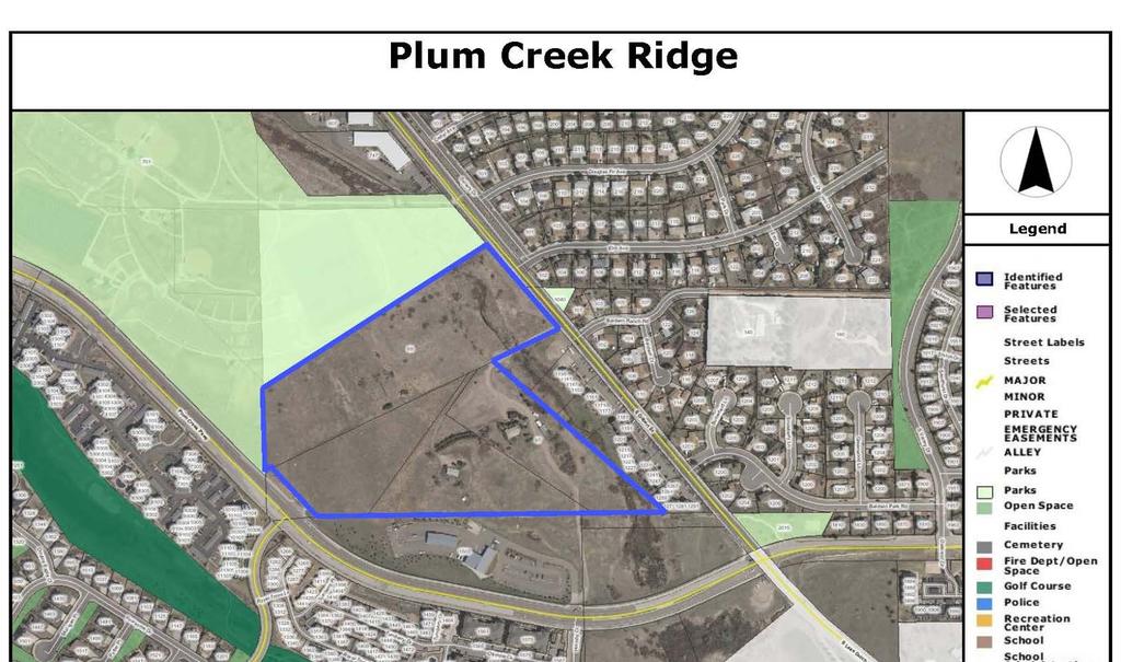
3 Item # 16 Meeting Date: June 3, 2014 AGENDA MEMORANDUM To: From: Title: Honorable Mayor and Members of Town Council Sandy Vossler, Planner II, Development Services Department Ordinance No : An Ordinance Amending the Town s Zone District Map by Approving the Plum Creek Ridge Planned Development Plan Amendment No. 1 and the Plum Creek Ridge Planned Development Zoning Regulations Amendment No. 1 (PDP ) Discussion Item Plum Creek Ridge Development Agreement (AGR ) Executive Summary The purpose and intent of this report is to seek Town Council approval of the proposed amendment to the Plum Creek Ridge Planned Development Plan (PDP) and the Plum Creek Ridge Planned Development (PD) Zoning Regulations on 1 st reading (Attachment B). In addition, the draft Plum Creek Ridge Development Agreement (DA) is being provided to Council as an informational item (Attachment C). The DA outlines the obligations of the Town and developer relative to the development of Plum Creek Ridge. A Resolution for approval of the DA will be presented to Town Council for action at the 2 nd reading of the Plum Creek Ridge PDP and PD Zoning Regulations. This acre PD is located northwest of the intersection of South Gilbert Street and Plum Creek Parkway (Attachment A). The proposed PDP and PD Zoning amendment would: Decrease the maximum density from 330 to 162 dwelling units; Increase total dedicated open space to 20% of the site; Reduce the minimum lot size, setbacks and building separation; and Eliminate the 40% maximum lot coverage. The proposed amendment meets the objectives of the Town s guiding documents and the review and approval criteria of the Municipal Code. Planning Commission held a public hearing on April 10, 2014 and voted 6-0 to recommend to Town Council approval of the proposed Plum Creek Ridge Planned Development Plan and PD Zoning Regulations (Attachment D). Staff recommends approval. 1
4 Notification and Outreach Efforts The proposed zoning amendment was noticed in accordance with the Town of Castle Rock Municipal Code. The applicant posted signs on the property and mailed letters to property owners and Homeowner Associations within 300 feet of the site at least 15 days prior to the public hearing. Town staff published notice on the Town s website and featured the proposal on the In Your Backyard map. Neighborhood Meetings The applicant held a neighborhood meeting on January 23 rd. Approximately eight people attended the meeting. After the applicant presented a summary of the proposed amendment, neighbors asked questions about traffic impacts, signalization, and cut through traffic. Overall, neighbors were happy with the reduction in density and extension of the pedestrian trail along Sellars Creek. External Referrals External referrals were sent to the various utility service providers, Douglas County School District, Colorado Department of Transportation and Douglas County Government. No objections to the rezoning were registered by the responding agencies. History of Past Town Council, Boards & Commissions, or Other Discussions Planning Commission On April 10 th, Planning Commission held a public hearing to consider the Plum Creek Ridge PDP and PD Zoning Regulations. The Commission asked questions about the water bank and lot sizes. Four members of the public addressed the Commission. Two spoke in favor of the reduced density, one person asked for limited access from the development to S. Gilbert Street and one person raised concerns about the developer s maintenance of existing fill material on the site. The Commission expressed support for the proposed density reduction and reduced water demands and voted 6-0 to recommend approval to Town Council. Discussion Current Zoning Plum Creek Ridge was annexed to the Town of Castle Rock and zoned Planned Development in The zoning created two use areas; Multi-family residential (R- MF) and Dedicated Use Area (DUA). Permitted residential uses include multi-family units and single-family attached and detached units. Public uses include trails, parks and utility facilities. The maximum gross density allows 330 total units. 2
5 Property Description The acre Plum Creek Ridge PD is located west of South Gilbert Street and north of Plum Creek Parkway. The property slopes from the southwest to the northeast toward Sellars Gulch and Creek which is located just east of the property and traverses the northeast portion of the property. The existing vegetation on the site is characterized by native grasses and shrubs. A portion of the property adjacent to Sellars Creek is located within the 100 year floodplain (Attachment B, Exhibit 3). The Preble s Meadow Jumping Mouse (Preble s Mouse) is a federally-protected species with habitat on this property. Most of the designated floodplain and Preble s Mouse habitat is included within the dedicated open space use area. The Plum Creek Ridge PD is surrounding by a variety of uses (Attachment E). The site directly abuts the Douglas County Fairgrounds and soccer fields to the north and west. To the east, the property is adjacent to The Sellers Landing multi-family condominium development. To the south the site borders the Centurylink Corporation facilities and undeveloped single-family and multi-family residential zoning within the Stanbro PD. Single-family detached residential neighborhoods are located east of South Gilbert Street and multi-family development is located south of Plum Creek Parkway. Proposed Planned Development Plan and PD Zoning Amendment The Plum Creek Ridge PD was annexed and zoned in 2005; however the acre site has remained undeveloped. Plum Creek Associates, LLC, represented by Eric Helwig, is requesting a rezoning of the property in order to reduce allowed densities and modify development standards for the site. Under the current zoning, the maximum number of dwelling units allowed is 330, resulting in a maximum number of units per acre of The proposed amendment would reduce the maximum number of units permitted to 162, which equates to 6.28 units per acre. The permitted uses would remain single-family attached and detached and multi-family along with public uses such as trails, parks, schools, outdoor recreation. Home occupations and places of religious assembly are also carried over from the original zoning to the amended PD. The amended PD proposes to increase the total open space dedication from 2.64 acres to a minimum of 5.16 acres (20% of the site). A 25 foot dedicated easement along the east boundary of the site will be used for extension of the Sellars Creek pedestrian trail and other passive recreational uses. Due to the size of the PD, public land dedication (PLD) is not being required, but rather a cash-in-lieu of PLD will be addressed in the Development Agreement. 3
6 A primary access to the site is planned at the existing Emerald Drive/Plum Creek Parkway intersection. A secondary access point is proposed at South Gilbert Street opposite the existing Elm Avenue. That secondary access may be limited to emergency vehicle access only with the Site Development Plan (SDP). The internal neighborhood streets will be configured with the future SDP, as well. The Traffic Impact Analysis (TIA) prepared for this amendment considered both a single and dual access alternative and the road network can support either option. The reduction in density correlates to a reduction in the vehicle trips per day generated by the project. Under the current zoning, 1,800 vehicle trips per day are anticipated, compared to 1,100 vehicle trips per day under the proposed rezoning and reduced density. The development standards for the PD are proposed to be amended to reduce the minimum area for single-family detached lots from 6,000 square feet (SF) to 5,000 SF. In addition, the single-family rear lot setback would be reduced from 30 feet or 20% of the lot depth to a straight 20 feet. Changes to multi-family development standards would include a reduced front setback from 20 feet to 10 feet. Where the site is adjacent to non-residential uses such as the Douglas County Fairgrounds to the north and west, and to the CenturyLink Corporation facilities to the south the site design will be subject to the Residential/Non-residential Interface Regulations, therefore setbacks for exterior property lines adjacent to public or private lands are being eliminated. Front and rear building separation for multi-family buildings are being simplified from 1 times the building height, to 35 feet. Finally, the maximum building lot coverage of 40% for multi-family would be eliminated. All other standards and height requirements remain unchanged. At the time of annexation and zoning, all groundwater rights associated with the property were dedicated to the Town and the Plum Creek Ridge Water Bank was created. Since the property has remained undeveloped, no debits have been made to the water bank and 120 single family equivalents remain in the bank. The Plum Creek Ridge Annexation and Development Agreement (DA) required the developer to provide additional water resources or pay cash-in-lieu of water rights if the water bank was exhausted prior to full build out of the property. Since the proposed amendment is a downzoning, this provision will remain a condition of the DA. Plum Creek Ridge Development Agreement (Informational Only) The Plum Creek Ridge Development Agreement is being introduced for information only (Attachment C). Town Council will be asked to consider and take action on a Resolution to approve the Development Agreement at the 2 nd reading of the Plum Creek Ridge PDP and PD Zoning Regulations. The Development Agreement outlines the obligations of the Town of Castle Rock and Plum Creek Associates, LLC (Owner) relative to the development of the property. The Plum Creek Ridge DA is intended to supersede previous Development Agreement 4
7 obligations associated with the development of the property. The proposed provisions of the Plum Creek Ridge DA include: Provision of Municipal Services; Development of infrastructure and facilities; Confirmation of conveyed Water Rights; Acceptance of additional water resources or cash-in-lieu of water rights if the Water Bank is exhausted prior to full development of the Property; Transportation improvements obligations; Intersection control improvements obligations; Cash-in-lieu of Public Land Dedications; and Trail construction obligations. The following analysis pertains to the proposed Plum Creek Ridge PDP and PD Zoning Regulations. Review Criteria and Analysis Vision 2020 Cornerstones The Vision 2020 is the Town s collective concept of what it wants to become in the future. Staff finds that the proposed amendment is consistent with the Vision 2020 Cornerstones as analyzed below: Town Identity: Preserve Castle Rock s character as a distinct and physically separate community that is the center of Douglas County. Preserve open space areas in and surrounding Castle Rock to protect the Town s natural beauty, ridgelines, and scenic views, and maintain a physical separation from surrounding communities. The proposed amendment increases the private open space dedication and extends the Sellars Gulch pedestrian trail which is an amenity for the community. Community Planning: Ensure the Town is carefully planned to accommodate the needs of existing and future residents, while preserving and protecting Castle Rock s Town identity and quality of life. Provide an adequate Town water supply through careful planning and financial investment. Encourage a broad range of housing types to provide for all household types, ages and income ranges within the community. Plan and provide for high-quality open space areas to accommodate community events, active and passive recreation, trail linkages, natural buffers, and environmental preservation. 5
8 The proposed amendment allows for new development of single-family and multi-family units, but at a reduced density. The reduction in density will require less water to serve the development. The 20% open space dedication provides a natural buffer between this development and the residential developments to the east. The open space also allows for trail linkages and protection of the sensitive flood plain and Preble s Mouse habitat Comprehensive Master Plan The 2020 Comprehensive Master Plan (Master Plan) is based on the concepts found in the Vision 2020 and establishes principles and policies intended to further guide the Town s growth and development. Staff finds that the proposed amendment supports the goals of the 2020 Comprehensive Master Plan as analyzed below: Land Use Plan Map and Matrix The Land Use Plan Map and Matrix (Plan Map) found in the Master Plan illustrates general categories of preferred land use intensities. The Plan Map identifies Plum Creek Ridge PD as an area of future residential uses which include single-family attached and detached and multi-family uses, as well as the recreational and public uses allowed by the Plum Creek Ridge PD Zoning Regulations. Cohesive residential areas that are safe, attractive and desirable places to live. LU-1.1 Create cohesive residential communities that include a school, a park or other recreation facilities, open space, community centers or neighborhood shopping. LU-1.2 Provide pedestrian and bicycle trails that link neighborhood amenities to allow safe and convenient access for all residents. LU-1.4 New development shall provide appropriate buffers or other mitigation measures between residential areas and other land use activities to minimize noise, traffic, or other conditions that may pose a nuisance or danger to residents. LU-1.6 Protect existing neighborhoods from traffic generated from outlying developments. The proposed amendment provides for increased open space, appropriate natural buffers and trail extensions. Infill development shall demonstrate compatibility with, and sensitivity to, existing neighborhood characteristics that promote harmonious transitions between neighborhoods. LU-3.1 Preserve the scale and character of existing neighborhoods. 6
9 The single-family and multi-family uses and building height maximums are not being amended and remain consistent with surrounding residential uses. The gross density would be significantly reduced; and therefore, is more compatible with the character of existing neighborhoods. Where the site is directly adjacent to developed residential, the dedicated open space provides a harmonious transition. Residential development preserves natural features and visual assets. U-4.1 Promote a development pattern that respects topographic features and preserves open space. LU-4.2 Encourage clustering of development in order to avoid site constraints or preserve site amenities, such as steep or unstable slopes, rock outcroppings, ridgelines, floodplains, or stands of trees. The proposed amendment creates use areas that avoid site constraints such as the floodplain and Preble s Mouse habitat. As noted the rezoning also proposes to almost double the dedicated private open space within the PD. Planned Development Plan Review and Approval Criteria Staff finds that the proposed amendment complies with the review and approval criteria as established in Section and as analyzed below. Community Vision/Land Use Entitlements 1. Complies with the most recent version of the Douglas County/Castle Rock Land Use Intergovernmental Agreement (IGA). This property was annexed to the Town in The site is within the Town s Urban Service Area, and as such, is anticipated by the IGA to develop at urban levels. 2. Conforms to the most recent versions of the Town's Vision, Comprehensive Master Plan and long range or master plans. As discussed previously in this report, the proposed rezoning supports the goals of the Town s Vision 2020 and 2020 Comprehensive Master Plan. 3. Complies with design principles found in Chapter Land Development General Design Principles. Plum Creek Ridge PD is an infill development that is substantially surrounded by improved and developed property. Water, sanitary sewer and storm sewer facilities are available in the area to serve this development. The proposed reduction in density promotes compatible and harmonious development of the 7
10 site in relation to surrounding uses. Adjacency to non-residential uses is indicated on the proposed PDP and buffering and mitigation will be required with the Site Development Plan. Two points of access to the site are proposed on the PDP, with the primary connection from Plum Creek Parkway at the Emerald Drive intersection. A secondary access point or emergency vehicle access point is proposed to connect with South Gilbert Street. The classification of the secondary access point will be determined with the SDP. Sidewalks and a trail extension will provide pedestrian connections through the development. The reduction in permitted units from 330 to 162 will reduce the water demand for the project. The 4.31 acres of dedicated open space will protect Preble s Mouse habitat, respect flood plain boundaries and provide a natural environment for extension of the Sellars Gulch trail. Relationship to Surrounding Area 1. Provides appropriate relationships between use areas, both internal and surrounding, with adequate buffer areas provided, if warranted. The open space corridor along the east boundary acts as a buffer from the abutting multi-family neighborhood. 2. Provides innovative and creative plan design and layout. The detailed site design will be accomplished with the future Site Development Plan. 3. Provides a variety of housing types, densities and open space. No changes to the permitted uses are proposed with the amendment; therefore the Plum Creek Ridge PD will continue to allow for the development of multifamily and single-family attached and detached housing products. 4. Identifies areas as mixed use and/or depicts areas that are buffer areas to comply with the residential/nonresidential interface regulations. This PD is adjacent to non-residential uses on the north, west and south boundaries, and with the design of the SDP, appropriate buffers between use areas will be created. 8
11 Circulation and Connectivity 1. Provides an adequate circulation system in terms of capacity and connectivity, which is designed for the type of traffic generated, safety, and separation from living areas, convenience, accessibility, noise, and exhaust control. The decrease in density will reduce the vehicle trips per day associated with the site and the impacts to surrounding roadways. The project is expected to generate 1,100 vehicle trips per day, a reduction of 39% over vehicle trips per day associated with the current zoning. Staff has reviewed the TIA and is satisfied that South Gilbert Street and Plum Creek Parkway have the capacity to accommodate the additional traffic related to this project. With the SDP, the internal street system and number points of access to the site will be finalized and again evaluated by staff. 2. Provides for emergency vehicle access. The primary access point to the site is proposed to be at the intersection of Plum Creek Parkway and Emerald Drive. The secondary access point onto South Gilbert Street will be either a full access or restricted to emergency vehicles only (EVA). That determination will be made with the future Site Development Plan. 3. Accommodates an adequate, functional and safe street system for vehicular traffic generated by the development and passing through the development. The intersection of Plum Creek Parkway and Emerald Drive is currently operating at a level of service D. Regardless of whether the project develops with a secondary full access point or an emergency vehicle access on South Gilbert Street, the level of service at Plum Creek Parkway and Emerald Drive will drop to E. The Town Public Works department will closely monitor that intersection to determine the warrants for a traffic signal. The developer of Plum Creek Ridge is required to contribute funds for that signal with the first plat of the project. 4. Provides for pedestrian and bicycle traffic in a safe and convenient manner, separation from vehicular traffic, and access to points of destination and recreation. The internal street system will be required to meet the Town s public works standards providing for pedestrian sidewalks. The Sellars Creek trail will be constructed by the developer and will further accommodate pedestrian and bike traffic. Services, Phasing and Off-Site Impacts 1. Addresses fiscal impact of the project. 9
12 The proposed PD Plan will generate review and impact fees, along with use taxes. The ongoing costs to serve the development in terms of public infrastructure and amenities, as well as police and fire, will be comparable to other residential developments within the Town. 2. Provides an appropriate phasing plan which minimizes unnecessary utility extensions and adequately addresses other fiscal concerns of the Town. The infrastructure is expected to be developed in a single phase; therefore, no phasing plan has been submitted. 3. Adequate water resources have been conveyed or purchased. Existing or proposed water and wastewater systems can support the proposed development pattern, uses and density. The groundwater rights associated with the property were conveyed to the Town at the time of annexation. The Plum Creek Ridge water bank contains 120 single family equivalents. The original DA allowed the developer to pay cash-in-lieu or attain additional water resources to serve the site with a density of 330 units. The reduction in density minimizes the shortfall between the water credits and the proposed development. 4. Existing or proposed stormwater systems can support the development and will comply with applicable regulations. Provides phased improvements in a logical and efficient manner. Stormwater impacts will be evaluated in more detail at the Site Development Plan stage. The Town found the applicant s stormwater evaluation sufficient for the PD Plan proposal. 5. Provides adequate consideration to the future extension of streets and utilities to adjacent properties. Since this is an infill property, infrastructure is in place surrounding this site to serve the development. The developer will be responsible for extending water and sewer mains to serve the site and for providing stormwater facilities. 6. Identifies and appropriately mitigates all traffic impacts, on- and off-site. As previously noted, the developer will be required to contribute to off-site signalization. Open Space, Public Lands and Recreation Amenities 1. Provides adequate trails, parks, recreation and open space. 10
13 The proposed amendment increases the open space to a minimum of 20% of the site. 2. Provides an adequate trail system in terms of internal circulation and appropriate external connections. A 10-foot wide paved trail within a 25 foot easement is planned within the open space corridor. This trail extension is part of the Town s trail network along the Gilbert Street corridor. 3. Provides functional open space for recreation, views, density relief, convenience, function, and preservation of natural features, including significant tree stands, ridges, and stormwater areas. Open space reservations and public land dedications are of an appropriate configuration and location within the site and comply with any applicable requirements of Chapter 16.08, CRMC and this Title. The most significant natural vegetation on the site is adjacent to Sellars Creek and will be preserved as part of the Preble s Mouse habitat. Preservation of Natural Features 1. Demonstrates sensitivity and limits disturbance to the site in terms of plan design and density to the site's major environmental characteristics including drainage ways, topography, view sheds and vegetation. The dedicated open space includes and maintains the Preble s Mouse habitat and floodplain. 2. The proposed PD Plan and zoning accommodate the Skyline/Ridgeline Protection Regulations in Chapter and reasonably mitigates visual impacts upon off-site areas. The site is not within the Skyline/Ridgeline Protection area. The north, west and south boundaries of the site are within the Residential/Non-Residential Interface area, which requires that appropriate mitigation and buffer elements be incorporated into the future Site Development Plan. 3. Consideration shall be given to wildlife impacts in the layout of open space areas. Where designated threatened or endangered species are present, the development must conform to all applicable state and federal restrictions and permitting requirements. Sellars Creek and Gulch are preserved by open space thereby avoiding impacts to wildlife, in particular the threatened Preble s Mouse, in this riparian area. 11
14 Based on this review and analysis, staff suggests that this PD amendment benefits the Town of Castle Rock and Town residents by: Increasing the open space dedication; Preserving the natural and environmentally sensitive area; Protecting Preble s Mouse habitat; Reducing the overall water demand of the project; Extending the Sellars Gulch trail; and Reducing traffic impact on surrounding roadways and intersections. Budget Impact The proposed PD Plan will generate review and impact fees, along with use taxes. Other ongoing costs to serve the Plum Creek Ridge neighborhood in terms of public infrastructure and amenities, as well as police and fire, will be comparable to other residential developments in Castle Rock. Planning Commission Recommendation Planning Commission and staff recommend approval of the amendment to the Plum Creek Ridge Planned Development Plan and Planned Development Zoning Regulations based on the following findings. The proposed amendment and zoning regulations: Meet the goals of the Vision 2020; Meet the policies and principles of the 2020 Comprehensive Master Plan; and Meet the review and approval criteria of the Municipal Code. Proposed Motion I move to approve Ordinance No , as introduced by title. Attachments Attachment A: Vicinity Map Attachment B: Ordinance Attachment C: Draft Plum Creek Ridge Development Agreement Attachment D: Planning Commission Minutes Attachment E: Surrounding Zoning and Uses 12
15
16
17
18
19
20

21
22 ATTACHMENT B DRAFT ORDINANCE NO AN ORDINANCE AMENDING THE TOWN'S ZONE DISTRICT MAP BY APPROVING THE PLUM CREEK RIDGE PLANNED DEVELOPMENT PLAN AMENDMENT NO. 1 AND THE PLUM CREEK RIDGE PLANNED DEVELOPMENT ZONING REGULATIONS AMENDMENT NO. 1 WHEREAS, Plum Creek Associates, LLC, (Owner) has requested an amendment to the PD Planned Development zoning of the property described in Exhibit 1 (Property); and WHEREAS, Owner has requested approval of the Plum Creek Ridge Planned Development Zoning Regulations Amendment No. 1 (Zoning Regulations) attached as Exhibit 2, as the same affect the Property; and WHEREAS, Owner has requested approval of the Plum Creek Ridge Planned Development Plan Amendment No. 1 (PD Plan) attached as Exhibit 3; WHEREAS, the PD Plan and Zoning Regulations are consistent with the Town s Vision 2020 and the Comprehensive Master Plan; and WHEREAS, public hearings on the PD Plan and Zoning Regulations have been held before the Planning Commission and Town Council in accordance with the applicable provisions of the Castle Rock Municipal Code; NOW, THEREFORE, IT IS ORDAINED BY THE TOWN COUNCIL OF THE TOWN OF CASTLE ROCK, COLORADO AS FOLLOWS: Section 1. Zoning Approval. The Plum Creek Ridge Planned Development Plan Amendment No. 1 and PD Zoning Regulations Amendment No. 1 are hereby approved. The Town s Zoning District Map pertaining to the Property is amended accordingly. Section 2. Severability. If any clause, sentence, paragraph, or part of this ordinance or the application thereof to any person or circumstances shall for any reason be adjudged by a court of competent jurisdiction invalid, such judgment shall not affect the remaining provisions of this ordinance. Section 3. Safety Clause. The Town Council finds and declares that this ordinance is promulgated and adopted for the public health, safety and welfare and this ordinance bears a rational relation to the legislative object sought to be obtained. APPROVED ON FIRST READING this 3rd day of June, 2014 by the Town Council of the Town of Castle Rock, Colorado by a vote of for and against, after publication in compliance with Section C of the Castle Rock Municipal Code; and
23 PASSED, APPROVED AND ADOPTED this day of, 2014, by the Town Council of the Town of Castle Rock by a vote of for and against. ATTEST: TOWN OF CASTLE ROCK Sally A. Misare, Town Clerk Approved as to form: Paul Donahue, Mayor Approved as to content: Robert J. Slentz, Town Attorney Bill Detweiler, Director of Development Services
24 LEGAL DESCRIPTION Portions of: A TRACT OF LAND SITUATED IN THE NORTH ½ OF THE NORTH ½ OF SECTION 13, TOWNSHIP 8 SOUTH, RANGE 67 WEST OF THE 6TH PRINCIPAL MERIDIAN, DOUGLAS COUNTY, COLORADO, MORE PARTICULARLY DESCRIBED AS FOLLOWS: COMMENCING AT THE SOUTHWEST CORNER OF THE NORTHWEST ¼ OF THE NORTHWEST ¼ OF SAID SECTION 13 AND CONSIDERING THE SOUTH LINE OF SAID NORTHWEST ¼ OF THE NORTHWEST ¼ TO BEAR NORTH 89 48'56" EAST WITH ALL BEARINGS CONTAINED HEREIN RELATIVE THERETO; THENCE NORTH 89 48'56" EAST ALONG SAID SOUTH LINE A DISTANCE OF FEET TO THE POINT OF BEGINNING; THENCE NORTH 89 48'56" EAST ALONG SAID SOUTH LINE A DISTANCE OF FEET TO THE SOUTHWEST CORNER OF SELLERS LANDING, RECEPTION NO ; THENCE NORTH 47 41'20" WEST A DISTANCE OF FEET TO THE NORTHWEST CORNER OF SELLERS LANDING; THENCE NORTH 64 33'11" EAST A DISTANCE OF FEET TO THE NORTHWEST CORNER OF SELLERS LANDING AND TO THE WESTERLY RIGHT OF WAY LINE OF LAKE GULCH ROAD; THENCE NORTH 38 47'04" WEST ALONG SAID WESTERLY RIGHT OF WAY LINE A DISTANCE OF FEET; THENCE SOUTH 57 05'37" WEST A DISTANCE OF FEET TO THE WEST LINE OF THE NORTHWEST ¼ OF THE NORTHWEST ¼ OF SAID SECTION 13; THENCE SOUTH 01 08'39" EAST ALONG SAID WEST LINE A DISTANCE OF FEET TO THE NORTHERLY RIGHT OF WAY LINE OF PLUM CREEK PARKWAY, FILING NO. 1, RECEPTION NO ; THENCE ALONG SAID NORTHERLY RIGHT OF WAY LINE FOR THE NEXT THREE (3) COURSES: 1. THENCE NORTH 64 33'52" EAST A DISTANCE OF FEET; 2. THENCE SOUTH 43 59'46" EAST A DISTANCE OF FEET TO A POINT OF CURVE; 3. THENCE ALONG A CURVE TO THE LEFT A DISTANCE OF FEET, SAID CURVE HAS A RADIUS OF FEET AND A CENTRAL ANGLE OF 02 35'11" TO THE POINT OF BEGINNING.
25 PLUM CREEK RIDGE Planned Development Plan Amendment No. 1 THE TOWN OF CASTLE ROCK, COLORADO ZONING REGULATIONS Prepared For: First Western Companies East Bethany Drive #200 Aurora, CO (303) Prepared By: Consilium Design, Inc South Alton Way, Suite 135 Centennial, CO (303) February 18, 2014
26 ZONING REGULATIONS FOR PLUM CREEK RIDGE Planned Development Plan Amendment No. 1 TABLE OF CONTENTS Page SECTION 1. General Provisions... 1 SECTION 2. Definitions... 1 SECTION 3. Land Use... 1 SECTION 4. Accessory Uses... 3 SECTION 5. Temporary Uses... 3 SECTION 6. Development Standards... 4 SECTION 7. Control Provisions... 5 SECTION 8. Site Development Plans & Plats... 5 SECTION 9. Transitional Uses... 5 SECTION 10. Severability of Provisions... 6
27 SECTION 1: GENERAL PROVISIONS ZONING REGULATIONS FOR PLUM CREEK RIDGE Planned Development Plan Amendment No Adoption/Authorization. The Town Council has adopted the Plum Creek Ridge Planned Development Plan #1 and Zoning Regulations pursuant to Section of Title 17 (Zoning) of the Castle Rock Municipal Code after appropriate public notice and hearing. 1.2 Applicability. The Plum Creek Ridge Planned Development Plan #1 and Zoning Regulations shall run with the and bind all landowners of record, their successors, heirs, or assigns of the land as approved by the Castle Rock Town Council. 1.3 Maximum Level of Development. The total number of dwelling units approved for development within the established Use Areas is the maximum allowed for platting and development. The actual number of dwelling units will be determined at the Plat and Site Development Plan stage of review based upon environmental constraints, utility and street capacity, compatibility with surrounding land uses, and other relevant factors. Any reduction in dwelling units of greater than 50 % shall require approval of Town Council. 1.4 Relationship to Town Regulations. The provisions of this Planned Development Plan #1 and Zoning Regulations shall prevail and govern the development of the Plum Creek Ridge PD, provided, however that where the provisions of this Planned Development Plan #1 and Zoning Regulations do not address a particular subject, the relevant provisions of the Town of Castle Rock Zoning Ordinance, as amended, or any other applicable provisions of the Town Municipal Code shall be applicable. 1.5 Phasing. The phasing order shall be indicated on the Site Development Plan. However no construction shall occur until the sanitary sewer easements are in place and U.S. Fish & Wildlife has approved the sewer location. 1.6 Development Agreement. In addition to these regulations, certain provisions of the development of this PD property are controlled by an agreement between the Town of Castle Rock and the PD property owners. This agreement, entitled, was adopted by the Town on the day of, 200, by Ordinance No.. SECTION 2: DEFINITIONS 2.1 In addition to the standard definitions found in the Town of Castle Rock Zoning Ordinance (Title 17), the following definitions of terms shall apply to this Planned Development: SECTION 3: LAND USE A. Building Ground Coverage. That portion of the ground on any building site which is covered by structures having a floor, walls and fully enclosed roof. Building ground coverage shall not include surface parking areas, roadways, bike paths or pedestrian ways or such other uses not meeting the above definition. B. Building Height. The vertical distance from the grade to the uppermost point of the roof structure. 3.1 Residential Use Areas. (PA-1, PA-2) A. Description: M/R Mixed Residential B. Principal Permitted Uses: 1
28 1. Residence-principal - Multi-family dwelling units; single family attached dwelling units; and single family detached dwelling units 2. Trails 3. Park / Playground / Outdoor Recreation (i.e., pool, court facilities) 4. School - Public or Private 5. Transportation R.O.W. 6. Home Occupations (including small in-home day care) - per section of the Town of Castle Rock Municipal Code 7. Churches, synagogues, and other religious institutions 8. Public utilities and related facilities 9. Public and quasi-public facilities C. Uses by Special Review: 1. Higher Education Facility 2. Private Indoor Recreation Facility 3.2 Open Space Use Areas, OSD, and OSP. A. Description: 1. OSD (Dedicated Open Space) - Land proposed to meet portions of the PD open space requirement of 20% for the entire parcel. OSD is to be dedicated to the Town, and maintained by the Town, or other public entity. 2. OSP (Private Open Space) - Land proposed to meet the PD open space requirement of 20% for the entire parcel. OSP is owned and maintained by private Owner s Association, or other private ownership. In addition, play facilities (acceptable to the Town s Park & Recreation Department) shall be allowed within OSP. B. Permitted Uses: 1. OSD: Passive recreation activities, preservation of land for public purposes, access roadways, landscaped areas, trails, and including such structures and other improvements not inconsistent with the Open Space land dedication and the Planned Development District ordinances. 2. OSP: Common areas located within Planning Areas 1 and 2, which may include, but not limited to, landscaped areas, swimming pools, cabanas, clubhouses, tennis courts, play areas, walkways and bikeways, but excluding driving and parking areas. C. The boundaries and/or location of use areas depicted on the plan may be changed or adjusted when finally designated at the time of the Site Development Plan, and shall not be considered a minor amendment to the Planned Development Plan #1, as long as the vital open space corridor and linkages are not eliminated and there is no reduction in the amount of total OSD or OSP area. D. Two OSD areas are indicated on the PD Plan. In addition to this OSD, the M/R use areas must provide the balance of the 20 percent of the gross site area as OSD or OSP at the time of Site Development Plan. 2
29 SECTION 4: ACCESSORY USES 4.1 Permitted In All Use Areas. A. Uses: 1. Underground utility and communications distribution lines 2. Roadways, bike paths, pedestrian trails 3. Parking areas 4. Open spaces and storm water drainage detention areas 5. Well sites 6. All Town owned and operated utilities and drainage areas 7. Other public and/or private utilities as authorized on a Plat and Site Development Plan SECTION 5: TEMPORARY USES 5.1 Permitted In All Use Areas. A. Uses: 1. Home/Builder sales and information offices/facilities and/or trailer provided that: a. Such temporary structure is located within a platted subdivision. b. Sales are limited to those units within the Plum Creek Ridge PD area. c. Adequate access, parking, sanitary facilities, and landscaping are provided. 2. Construction office and/or trailer. 3. Dwelling units to be used as models and/or sales and information offices; provided the unit so utilized is a permitted use in the use area where it is located. 3
30 SECTION 6: DEVELOPMENT STANDARDS 6.1 Overall Project Standards. The standard zoning requirements of the Town of Castle Rock Zoning Ordinance including off-street parking, landscaping, site development, accessory and temporary uses, uses by special review and variance processes shall apply to this PD, except as modified by the following: A. M/R Standards: 1. Maximum Level of Development Dwelling Units 2. Minimum Lot Area (for single family detached use) S.F. Min. 3. Multi-Family Minimum Setbacks For Principal And Accessory Structures From: a). Front Property Line - 10 feet b). OSD and OSP - 15 feet c). Internal access drives/parking areas - To be determined at Site Development Plan, based on architectural characteristics 4. Single Family Minimum Setbacks: a). Front Setback to Garage - 20 feet b). Front Setback to Side Load Garage: - 10 feet c). Side Yard (interior lot line): - 5 feet d) Side Yard (corner lot line): - 15 feet e). Rear Yard: - 20 feet e). Accessory Structure: - 5 feet side & rear 5. Multi-Family Minimum Principal Building Separation a). Front and Rear Building Separation: - 35 feet b). Side to Rear Building Separation: - 25 feet c). Side to Side Building Separation - 2 story bldg.: - 10 feet - 3 story bldg.: - 15 feet 6. Maximum Building Height a). Two Story Building: b). Three Story Building - Flat Roof: c). Three Story Building - Pitched Roof: - 35 feet - 40 feet - 50 feet 7. No structures shall be constructed within the 100-year flood plain. 6.2 Exterior Lighting. Exterior lighting shall conform with Town of Castle Rock outdoor illumination standards. 6.3 Utilities. All public utility distribution lines must be placed underground. 6.4 Trails. The trail system as shown on the Planned Development Plan Amendment No. 1 is conceptual, showing general trail locations only. The exact location of each trail and the construction materials shall be determined during the Site Development Plan submittal process. 6.5 Architecture. Building and site design shall comply with the Town of Castle Rock Design Guidelines and Residential / Non-Residential Interface Regulations. 4
31 SECTION 7: CONTROL PROVISIONS 7.1 Use Area Boundaries. There shall be some limited flexibility in determining the exact location of Use Area boundaries due to the scale of the drawing and the somewhat diagrammatic depiction of Use Areas (rounded corners, separation from other areas, etc.) However, changes or adjustments to boundaries may only be made through the PD Amendment procedure as provided in the Town of Castle Rock Municipal Code Chapter Road Alignments. The Planned Development Plan Amendment No. 1 is intended to depict general locations of roadways, and access points. Recognizing that final road alignments are subject to engineering studies, access road realignments are expected, and can be accomplished by the developer through the platting process, without any amendment to this ordinance or to the Plan itself. SECTION 8: SITE DEVELOPMENT PLANS AND PLATS 8.1 Submission of Site Development Plans and Plats and Additional Information. Following approval of the Planned Development Plan, the property owners shall submit a Site development Plan (SDP) for all or any portion or portions of the general use areas as are then ready for development. No building permit will be issued until a SDP and plat have been approved for the property by the Town and duly recorded. SECTION 9: TRANSITIONAL USE 9.1 Transitional Use. After approval of the Planned Development Plan Amendment No. 1 incorporated as part of this amendment to the Town of Castle Rock Zoning District Map, any portion of the Plum Creek Ridge PD which does not have an approved Site Development Plan may be used for agricultural purposes and all pre-existing residential uses. These uses may continue until a Site Development Plan for such property is approved, or until such a time that the Town Council determines that the proximity of these uses to developed areas provides a negative impact to the health, safety or welfare of residents / owners of such developed areas. Permitted agricultural uses include farming, ranching, gardening, and the buildings accessory to these uses. In no event shall commercial feed yards, poultry or hog farms be permitted. The two pre-existing residences located within the property and all pre-existing accessory buildings and uses shall be permitted transitional uses. Transitional use areas shall be closed to vehicular traffic and off-road recreational motor biking excepting agricultural vehicles and implements, emergency vehicles, vehicles associated with the pre-existing uses, vehicles engaged in utility and maintenance work, and designees of the development and /or Town. Any activity permitted by this section shall be considered to be valid pre-existing non-conforming use within the area described above until a Site Development Plan for such area or areas has been approved; Provided however, that the Town Council reserves the right to prohibit such agricultural uses in areas for which no Site Development Plan has been submitted if the Council determines that due to the proximity of such uses to developed areas a danger exists to the health, safety or welfare of the residents of such developed area(s). 5
32 SECTION 10: SEVERABILITY OF PROVISIONS 10.1 Severability Of Provisions. In the event that any provision hereof shall be determined to be illegal or void by the final order of any court of competent jurisdiction, the remaining provisions shall remain in full force and effect. Passed and adopted this day of, 200, by a vote of the Town Council of Castle Rock, Colorado, For, and Against. ATTEST: TOWN CLERK MAYOR, TOWN OF CASTLE ROCK 6
33 Plum Creek Ridge Planned Development Plan Amendment No. 1 (Formerly Preliminary PD Site Plan) FIRST WESTERN COMPANIES E Bethany Drive #200 Aurora, CO Tel: South Alton Way, Suite 135 Centennial, CO Tel: Fax: Pinon Place Erie, CO Tel: Fax:
34 Plum Creek Ridge Planned Development Plan Amendment No. 1 (Formerly Preliminary PD Site Plan) Plum Creek Ridge PA-2 M/R 1.36 AC 0 to 8.82 DU/AC 0 to 12 UNITS PA-3 OSD (DEDICATED OPEN SPACE) 4.31 AC PA-1 M/R AC 4.98 to 7.46 DU/AC 100 to 150 UNITS
35 Plum Creek Ridge CALL 2 BUSINESS DAYS IN ADVANCE BEFORE YOU DIG, GRADE, OR EXCAVATE FOR THE MARKING OF UNDERGROUND MEMBER UTILITIES. LEGEND Planned Development Plan Amendment No. 1 (Formerly Preliminary PD Site Plan) NORTH PLUM CREEK RIDGE UTILITY PLAN PREPARED FOR 2063 Pinon Place Erie, CO
36 Plum Creek Ridge LEGEND Planned Development Plan Amendment No. 1 (Formerly Preliminary PD Site Plan) NORTH 2063 Pinon Place Erie, CO PREPARED FOR RETAINING WALL TYPICAL SECTION PLUM CREEK RIDGE GRADING PLAN CALL 2 BUSINESS DAYS IN ADVANCE BEFORE YOU DIG, GRADE, OR EXCAVATE FOR THE MARKING OF UNDERGROUND MEMBER UTILITIES. 4 4
37 DRAFT 5/16/4/21/14 AMENDED AND RESTATED PLUM CREEK RIDGE DEVELOPMENT AGREEMENT DATE:, PARTIES: TOWN OF CASTLE ROCK, a home rule municipal corporation, 100 N. Wilcox, Castle Rock, Colorado (Town). RECITALS: PLUM CREEK ASSOCIATES, LLC, a Colorado limited liability company, E. Bethany Drive, Suite 200, Aurora, Colorado (Owner). A. The parties have determined that it is in their mutual interest to make certain changes to the Plum Creek Ridge Annexation and Development Agreement in conjunction with the concurrent approval of the Plum Creek Ridge Planned Development Plan Amendment No. 1 ( PDP ) and rezoning of the Property described in the attached Exhibit 1 ( Property ). B. In order to preserve the original intent and partial performance of the parties to date, certain terms and provisions are restated in this Agreement, even though such terms or provisions may have already been performed or satisfied by the parties. C. The parties acknowledge that this agreement contains reasonable conditions and requirements to be imposed upon the development of the Property, and that these restrictions are imposed to protect and enhance the public health, safety and welfare of current and future residents of the Town. COVENANTS: THEREFORE, in consideration of these mutual promises, the parties agree and covenant as follows: ARTICLE I DEFINITIONS 1.01 Defined Terms. Unless the context expressly indicates to the contrary, the following words when capitalized in the text shall have the meanings indicated:
38 DRAFT 05/23/14/2/27/14 Agreement: this Amended and Restated Plum Creek Ridge Development Agreement and any amendments to this Agreement. Charter: the Home Rule Charter of the Town, as amended. Code: the Castle Rock Municipal Code, as amended. Development Exactions: the fees and charges imposed by Town under the Town Regulations on development, including the System Development Fees. Development Plan: the Plum Creek Ridge PD Zoning Regulations, Planned Development Plan Amendment No. 1, and the associated preliminary utility, drainage and transportation plans. Facilities: the infrastructure prescribed by Town Regulations necessary to furnish Municipal Services and Public Utilities to the Property, including the infrastructure required to extend or connect the Facilities to complimentary infrastructure off-site of the Property. Municipal Services: police and fire protection, water and wastewater, stormwater drainage and detention, transportation and street maintenance, general administrative services including code enforcement and any other service provided by Town within the municipality under its police powers. Owner: the person(s) in title to any portion of the Property, according to the records of the Douglas County Clerk and Recorder. The use of the singular "Owner" shall refer to all Owners of the Property, unless the context of the Agreement otherwise limits the reference. As of the date of execution of this Agreement the Owner of the Property is Plum Creek Associates, LLC, a Colorado limited liability company. Plans: the plans, documents, drawings and specifications prepared by or for Owner for the construction, installation or acquisition of the Facilities, as approved by the Town. Plat: a subdivision plat of a portion of the Property. Planned Development Plan or PDP: the Plum Creek Ridge Planned Development Plan, Amendment No. 1 recorded at Reception No. of the public records of Douglas County, Colorado. Property: the real property described in the attached Exhibit 1. Public Utilities: the infrastructure necessary to extend services (other than Municipal Services) to the Property, which are provided by a public or quasi-public utilities.
39 DRAFT 05/23/14/2/27/14 Site Development Plan: the zoning document prescribed under Title 17 of the Code. SIA: a Subdivision Improvements Agreement entered into between the Town and the subdivider of a Plat, as required under the Code. System Development Fees: the capital recovery charges for water and wastewater plant imposed under of the Code. Town Regulations: the Charter, ordinances, resolutions, rules and regulations of the Town, including the Code, and the provisions of all zoning, subdivision and building codes, as the same may be amended from time to time and applied uniformly throughout the Town. Water Rights: the right and interest to all Denver basin ground water underlying the Property, adjudicated in Case No. 04CW042. Certain other terms are defined in the text of the Agreement and shall have the meaning indicated Cross-reference. Any reference to a section or article number, without further description, shall mean such section or article in this Agreement. ARTICLE II APPLICATION AND EFFECT 2.01 Binding Effect. The Agreement shall apply to the Property and its covenants shall be binding upon the successors and assigns of the parties in the same manner and to the same effect as if such successors were signatories to the Agreement. The parties acknowledge that the Property is both benefited and burdened by the mutual covenants of this Agreement, and such covenants shall constitute real covenants binding upon successors in interest to the Property, including any mortgagees or lienholders, irrespective of whether specific reference to this Agreement or its covenants is made in any instrument affecting title to the Property Owner Responsibility. The Owner of the Property upon which development approval is requested shall have the ultimate responsibility for performance of the covenants and obligations assumed by Owner under this Agreement, irrespective of whether development activity on the Property is undertaken by the Owner, a third party on behalf of
40 DRAFT 05/23/14/2/27/14 and/or with the authorization of the Owner. Town shall accept performance of the covenants of the Agreement from a developer on behalf of Owner, unless such performance requires the conveyance, encumbrance or security of the Owner's interest in the Property, in which event the express consent or joinder of the Owner shall be required Town Regulations. Unless otherwise provided in this Agreement, Town Regulations shall apply to the Property in the same manner and effect as within other areas of the municipality. Unless expressly stated to the contrary in this Agreement, the Agreement shall not in any manner restrict or impair the lawful exercise by the governing body of the Town of its legislative, quasi-legislative or other police powers as applied to the Property, including specifically, the amendment, modification or addition to the Town Regulations, subsequent to the execution of this Agreement. When this Agreement calls for compliance with the Town Regulations, the operative Town Regulations in effect at the time such compliance is required shall govern, unless the provisions of this Agreement expressly provide to the contrary. ARTICLE III GENERAL OBLIGATIONS 3.01 Municipal Services. Subject to the further provisions Article VII, Town shall provide the Property with Municipal Services. Town reserves the right to contract with other governmental or private entities for delivery of Municipal Services to the Property, provided such service level is comparable to that provided by the Town in its proprietary capacity, and services are provided on the same terms and conditions as provided in other portions of the Town. The respective obligations of the parties for development of the infrastructure necessary for provision of the Municipal Services to the Property is addressed in Article V Permitted Development. Owner shall develop the Property in accordance with this Agreement and Town Regulations, and applicable state and federal law and regulations. Town shall allow and permit the development of the Property in accordance with the Development Plan and the Town Regulations, upon payment of fees, exactions and charges imposed by the Town Regulations, including Development Exactions, and compliance with conditions precedent to permitting imposed by this Agreement or Town Regulations. Town
41 DRAFT 05/23/14/2/27/14 shall coordinate with Owner in any filings or applications before other governmental jurisdictions necessary for Owner to fulfill its obligations under this Agreement or to allow development of the Property, in accordance with this Agreement. Town shall not unreasonably withhold consent to or approval of a development request or application. ARTICLE IV WATER RIGHTS 4.01 Requirement. It is the obligation of Owner to convey to Town the Water Rights (together with additional water resources, if needed in accordance with this Agreement), to support Town's obligation to provide a municipal water supply to the Property in accordance with this Agreement. Town shall have no obligation to issue land use approvals for additional development on the Property unless Owner is in compliance with the provisions of this Article IV Conveyance. Owner has conveyed to Town by special warranty deed, free and clear of all liens and encumbrances, marketable title to Water Rights. Post-conveyance, Owner shall execute such further reasonable and additional instruments of conveyance and other documents which Town reasonably determines necessary to grant to the Town the exclusive ownership, management and control of the Water Rights. However, should it be determined that marketable title to any portion of the Water Rights did not vest in the Town with the conveyance of same, the Water Credit established in 4.03 shall be reduced accordingly Water Credit. With conveyance of the Water Rights, a credit of 7 SFE was established against the Town s water dedication requirements for the benefit of the Property (Water Credit). In order to address the disparity between the Water Credit realized from conveyance of the Water Rights and the estimated water supply required for development of the Property in accordance with the Development Plan, Owner has concurrently transferred 113 SFE from the Oaks of Castle Rock Water Bank, established under the Oaks Development Agreement, resulting in a total Water Credit of 120 SFE. This initial Water Credit of 120 SFE shall not be affected by changes in the conversion rate of Water Rights into SFE
42 DRAFT 05/23/14/2/27/14 that the Town may implement through modifications to the Town Regulations after the date of this Agreement. In the event Owner receives the appropriate governmental approvals for development of the portion of the Property located in the area designated as flood plain, Owner shall transfer additional SFE from the Oaks of Castle Rock Water Bank to meet the water supply demand for such additional development (Phase 2 Transfer). The Phase 2 Transfer shall not be affected by changes in the conversion rate of Water Rights into SFE that the Town may implement through modifications to the Town Regulations after the date of this Agreement. The Water Credit is expressed as a single-family equivalent. An SFE is the measure of average annual wholesale water production that must be developed to meet the imputed demand from a single-family residence under the Town Regulations. Consequently, 1 SFE of Water Credit represents that the holder has satisfied the Town s water dedication requirement for one single-family residence Application of Water Credit. The Water Credit established under 4.03 shall be reduced (i.e. applied): (a) at the time of Plat approval by the total SFE assigned to all approved development (private and public) to the extent the water demand for such use can be determined at Plat approval; and (b) at the time of Site Development Plan approval or at building/irrigation permit issuance for those uses not accounted for at the time of Plat approval Water Bank. In order to properly account for the Water Credit, Town shall administratively maintain an account designated the Plum Creek Ridge Water Bank. The Plum Creek Ridge Water Bank shall periodically be debited or credited in accordance with this Article IV. The Water Bank shall be formatted as follows:
43 DRAFT 05/23/14/2/27/14 PLUM CREEK RIDGE WATER BANK Entry Date Recorded Recording Info SFE Demand SFE Supply Deeds to Water Rights 7 7 Net Transfer from Oaks Water Bank Phase 2 XX 120+XX Transfer Final Plat YY 120+XX-YY With any entry made by the Town, the Owner of the Water Bank (see 4.06) shall receive notification in writing, and any objection not resolved to the satisfaction of the Owner at the administrative level shall be referred to a mutually acceptable independent water engineer whose determination made in accordance with this Agreement shall be final and binding Ownership and Transfer of Water Credit. The Water Credit shall be applied in accordance with this Agreement on a "first-come, first-served" basis to approved development within the Property on a per unit basis, unless the Owner(s) direct the Town in writing to allocate a certain portion of the Water Credit for use on a specific portion of the Property (Allocated Water Credit). In the event of such allocation, the Allocated Water Credit may be used exclusively for the designated portion of the Property. The Allocated Water Credit may be transferred only after it is determined that the Allocated Water Credit exceeds the demand for the designated portion of the Property, in which event the Owner may reallocate the surplus for use on portions of the Property. Owner may grant a security interest in the Water Credit to a creditor, provided that such creditor s use of the Water Credit upon foreclosure of the security interest shall be subject to all rights, conditions and restrictions contained in Article IV. The Water Credit may not be assigned or transferred for use on properties other
44 DRAFT 05/23/14/2/27/14 than the Property, provided that after Town and Owner have agreed that full development has occurred, the total water demand for the Property has been determined, the Water Credit has been applied or allocated to meet such demand, and a surplus remains in the Water Bank, any unused portion of the Water Credit remaining shall revert to the Town Required Water Sources. If the Water Bank is exhausted prior to full development of the Property, the Owner shall be required to provide additional water resources or pay to Town cash-in-lieu of water rights in accordance with Town Regulations then in effect. Absent provision of such additional water resources, Town shall not be obligated to approve further development approvals for the Property. ARTICLE V FACILITIES DEVELOPMENT 5.01 General Responsibility. Except for the Town Facilities as defined in 5.03, development of the Facilities shall be the exclusive obligation of Owner, and Owner shall bear the cost of planning, design, construction and financing of the Facilities and all other related and incidental activities. The Facilities shall be developed in strict accordance with Town Regulations, the Development Plan, this Agreement and the applicable SIA and Plat. Except as otherwise expressly provided in this Agreement, Town shall have no obligation to develop Facilities Cooperation in Facilities Development. Town and Owner shall cooperate in obtaining necessary permits and approvals required by other governmental agencies in order to develop Facilities. Town shall apply for any such permits or approvals in its name or in the joint names of the Town and Owner, if so required by the governmental agencies Town Facilities. Town shall have the exclusive obligation to undertake those Facilities for which the System Development Fees are imposed, including water supply, treatment and storage, and wastewater collection and treatment (Town Facilities). Water and wastewater mains which are the responsibility of the Owner under the Town Regulations are not Town Facilities 5.04 Facilities Control. Upon dedication of Facilities by Owner and acceptance by Town, Town shall have the exclusive management control of the Facilities and all capacities
45 DRAFT 05/23/14/2/27/14 therein. Town may use or allow others to use the capacities in Facilities, provided that the capacities developed by Owner at Owner's cost shall be reserved for the benefit of the Property, or if used by Town to serve other properties, Town shall provide replacement or alternative capacities in such a manner as to not impede development on the Property. Town s failure to do so constitutes an event of default under Article VII. In the event Owner is required to construct Facilities that are sized to serve areas within the Town other than the Property, Town shall make best efforts to recoup Owner s costs on a pro rata basis, of oversizing the Facilities from those properties that benefit from the oversized Facilities Subdivision Improvements Agreement. The Town Regulations require that a subdivider enter into a SIA at the time of approval of a Plat. The SIA addresses with greater specificity the Facilities to be constructed to serve the Plat and the financial guarantees to assure construction of the Facilities. Unless modified in the SIA, the provisions of this Article V will apply to the development of such Facilities, irrespective of whether or not reference to this Article V is made in the SIA Off-site Facilities. Owner shall be obligated to acquire the necessary easement or fee interest (as required by Town) from adjacent properties necessary to develop all off-site Facilities. In the event Owner is unable to acquire such property interests, Town shall make best efforts to exercise its powers of eminent domain to condemn the necessary property, provided Owner has furnished Town with appropriate assurances and financial guarantees to cover the costs of such acquisitions Transportation Improvements. Owner shall be required to construct all turn lane improvements as recommended in the traffic impact study for the access point onto Gilbert Street, as needed. Concurrently with and as a condition to recordation of the first Plat on the Property, Owner shall pay to Town $71,770 as its proportionate share of the improvements constructed by Town to Plum Creek Parkway access at Emerald Drive Intersection Control Improvements. Owner shall pay to Town its proportionate share of the following intersection control improvements concurrently with and as a condition to recordation of the first Plat on the Property: (a) $8,300 for the Plum Creek Parkway/Gilbert Street intersection; and
46 DRAFT 05/23/14/2/27/14 (b) $20,749 for the Plum Creek Parkway/Emerald Drive intersection. Town will construct the improvements when an engineering study has been completed and it is determined intersection control warrants are met Sidewalk Improvements. Concurrently with and as a condition to recordation of the first Plat on the Property, Owner shall pay to Town $11,520 as its proportionate share of the 5-foot sidewalk constructed by the Town adjacent to its Property boundary along Gilbert Street No Credit. The Property shall not be entitled to any credit or offset against any Development Exaction as a result of the payments made under this Article V. ARTICLE VI PUBLIC LAND DEDICATION 6.01 Public Land Dedication. Concurrently with and as a condition to recordation of the each Plat on the Property, Owner shall pay to the Town cash in lieu of public land dedication for that portion of the for the entire Property being platted. The cash-in-lieu amount shall be in an amount calculated at the rate in effect at the time of Plat approval. of $1656 per dwelling unit for dwelling units approved with Plat and/or Site Development Plan, together with interest on such sum at the rate of 5% per annum, from the date of recordation of this Agreement. Should additional dwelling units be approved by amended Plat or Site Development Plan, cash-in-lieu for such units at $1656 per dwelling unit plus interest shall be due Trail Construction. Owner shall install a 10' concrete trail through the project and dedicate a 25' easement as shown on the PD site plan. ARTICLE VII DEFAULT AND REMEDIES 7.01 Event of Default. Failure of Town or Owner to perform any covenant, agreement, obligation or provision of this Agreement, constitutes an event of default under this Agreement Remedies. In addition to specific remedies provided elsewhere in the Agreement upon default, the non defaulting party shall have the right to take whatever action
47 DRAFT 05/23/14/2/27/14 at law or in equity appears necessary or desirable to enforce performance and observation of any obligation, agreement or covenant of the defaulting party under the Agreement, or to collect the monies then due and thereafter to become due subject to any express limitations on remedies provided elsewhere in this Agreement. In any such legal action, the prevailing party shall be entitled to recover its reasonable attorney's fees and litigation costs from the other party Default Notice. In the event either party alleges that the other is in default, the non-defaulting party shall first notify the defaulting party in writing of such default, and specify the exact nature of the default in such notice. The defaulting party shall have thirty (30) business days from receipt of such notice within which to cure such default before the nondefaulting party may exercise any of its remedies hereunder; provided that (i) such default is capable of being cured, (ii) the defaulting party has commenced such cure within said 30-day period, (iii) the defaulting party diligently prosecutes such cure to completion. If such default is not of a nature that can be cured in such thirty (30) day period, corrective action must be commenced within such period by the defaulting party and thereafter diligently pursued. ARTICLE VIII GENERAL PROVISIONS 8.01 Amendment. Any and all changes to this Agreement, in order to be mutually effective and binding upon the parties and their successors, must be in writing and duly executed by the signatories or their respective representative, heirs, successors or assigns Interpretation. In this Agreement unless the context otherwise requires: (a) All definitions, terms, and words shall include both the singular and the plural; (b) Words of the masculine gender include correlative words of the feminine and neuter genders, and words importing the singular number include the plural number and vice versa; and (c) The captions or headings of this Agreement are for convenience only and in no way define, limit or describe the scope or intent of any provision, article, or section of this Agreement Notice. The addresses of the parties to this Agreement are as listed below. Any
48 DRAFT 05/23/14/2/27/14 and all notices allowed or required to be given in accordance with this Agreement are deemed to have been given when delivered to the other parties or five (5) days following the date the same is deposited in the United States mail, registered or certified mail, postage prepaid, return receipt requested addressed to the other parties at the addresses noted, or such address as is subsequently endorsed in writing, or in the event of transfer of the Property to the address of such grantee as indicated in the recorded instrument whereby such grantee acquired an interest in the Property. TOWN: OWNER: Town Attorney Town of Castle Rock 100 Wilcox Street Castle Rock, CO Plum Creek Associates, LLC E. Bethany Drive, Suite 200 Aurora, CO Severability. It is understood and agreed by the parties hereto that if any part, term, or provision of this Agreement is by the Courts held to be illegal or in conflict with any law of the State of Colorado, the validity of the remaining portions or provisions shall not be affected, and the rights and obligations of the parties shall be construed and enforced as if the Agreement did not contain the particular part, term, or provision held to be invalid Verification. The Town and the Owner shall provide the other written verification regarding the status, performance or completion of any action required of the Town or the Owner under the Agreement or by the terms of any other agreement Entire Agreement. This instrument embodies the whole agreement of the parties. There are no promises, terms, conditions, or obligations other than those contained herein; and this Agreement shall supersede all previous communications, representations, or agreements, either verbal or written TABOR Escrow. Whenever this Agreement calls for a payment from Owner to Town, Town may direct that such payment be made into an established escrow, from which the Town may disburse such funds directly to third party contractors, suppliers, vendors, consultants to accomplish the project for which such funds were paid according to
49 DRAFT 05/23/14/2/27/14 the terms of this Agreement Conflicts. If the terms and provisions of this Agreement are in conflict with the Town Regulations, the terms and provisions of this Agreement, as it may be amended from time to time shall control.
50 DRAFT 05/23/14/2/27/14 ATTEST: TOWN OF CASTLE ROCK Sally A. Misare, Town Clerk Paul Donahue, Mayor Approved as to form: Robert J. Slentz, Town Attorney STATE OF COLORADO ) ) ss. COUNTY OF ) The foregoing instrument was acknowledged before me this day of, 2014, by Sally A. Misare as Town Clerk and Paul Donahue as Mayor for the Town of Castle Rock, Colorado. Witness my official hand and seal. My commission expires:. ( S E A L ) Notary Public
51 DRAFT 05/23/14/2/27/14 PLUM CREEK ASSOCIATES, LLC, a Colorado limited liability company By: Its: STATE OF COLORADO ) ) ss. COUNTY OF ) The foregoing instrument was acknowledged before me this day of, 2014, by as for Plum Creek Associates, LLC, a Colorado limited liability company. Witness my official hand and seal. My commission expires:. ( S E A L ) Notary Public
52
53
54

55 Planning Commission Regular Meeting April 10, 2014 Minutes Chair Fronczak called the meeting to order at 6:07 p.m. Roll Call: Commission Members Present: Commissioners Michael Fronczak (Chair), Chris Horton (Vice-Chair), Leslie Lee, William Placke, Donald Eby, and Mark Luongo Commission Members Absent: None (there is one vacancy on the Commission Town Council Liaison: Joseph Procopio Staff Members Present: Bill Detweiler, Development Services Director Heather Lamboy, Development Services Assistant Director Sandy Vossler, Planner II Andrea Trujillo, Recording Secretary in Training Melinda Pastore, Recording Secretary Certification of Meeting: Staff confirmed that notice of this meeting and the agenda had been posted and witnessed in accordance with the requirements of the Open Meetings Law. Resolution of Appreciation Barbara Dash: Chair Fronczak presented former Planning Commissioner, Barbara Dash, with a Resolution of Appreciation, which was approved at the February 27th meeting. Three former Planning Commissioners were present and they, along with the current Commissioners, thanked Mrs. Dash for her work as a Planning Commissioner and for her many contributions to Castle Rock. Resolution of Appreciation Chris Horton: Chair Fronczak read a Resolution of Appreciation, Resolution No. PC , honoring the service of Chris Horton as a Planning Commissioner. Passed: The Commission expressed their appreciation to Commissioner Horton and Council Member Procopio, as this was their last meeting. In addition, Chair Fronczak congratulated Town Manager Mark Stevens, as he was recently awarded the Castle Rock Advocate Award by the Castle Rock Chamber of Commerce. Approval of Minutes March 27, 2014 Regular Meeting: Commissioner Lee moved to approve the minutes as written. The motion was seconded by Commissioner Luongo. Passed: Public Hearing Item: An Ordinance Amending the Town s Zone District Map by Approving the Plum Creek Ridge Planned Development Plan Amendment No. 1 and the Plum Creek Ridge Amendment No. 1 Planned Development Zoning Regulations: (6:33 p.m.)
56 The staff report and PowerPoint presentation were entered into the public record. Ms. Sandy Vossler presented the proposed amendment, which would reduce densities in the Plum Creek Ridge Planned Development (PD), which is located south of the Douglas County Fairgrounds between S. Gilbert Street and Plum Creek Parkway. The proposed density reduction would be from 330 units to 162 units, while adjusting some of the setbacks and single-family lot size requirements. Staff recommended approval, finding the proposal in compliance with Town review criteria and noting that the proposal would increase open space and provide an extension of the Sellars Gulch trail through the property. Staff explained that water bank demands would be lower with reduced density. Applicant Presentation: (6:45 p.m.) Mr. Eric Helwig, from Plum Creek Associates, LLC, presented. The applicant described their desire to pull lots back from the flood plain and Preble s Mouse habitat, which the smaller setbacks helped them accomplish. They would likely develop a mixture of townhomes and single-family residences. Neighborhood meetings were held and in general the proposal was viewed favorably. The only significant neighborhood concerns involved the streets. There was concern over increased traffic onto Gilbert Street, so the applicant is considering having the connection onto Gilbert Street serve as emergency access only. Concern was also expressed regarding traffic at the intersection of Emerald and Plum Creek Parkway. The applicant said they are required to contribute to traffic signal costs at this intersection, which should solve the issue if the Town decides to install a signal at this location. Public Comment: (7:00 p.m.) Two members of the public spoke in favor of reducing density. One had concerns about the developer s maintenance of the fill material, which recently blew onto cars and windows at the Sellers Landing Apartments. The other requested that access onto Gilbert Street be limited. Motion: (7:15 p.m.) Based on the findings of fact presented by the staff report, Vice Chair Horton moved to recommend to Town Council approval of the Plum Creek Ridge Planned Development Plan Amendment No. 1 and the Plum Creek Ridge Amendment No. 1 Planned Development Zoning Regulations. The motion was seconded by Commissioner Lee. Passed: 6-0 Commissioner Items: A. Quorum for Regular Meeting April 24, 2014: This meeting was cancelled; however, the Planning Commission will participate in an I-25 Community Team meeting the evening of April 24 th. All Commissioners, except Commissioner Luongo, indicated they would attend this meeting. B. Quorum for Regular Meeting May 8, 2014: Commissioner Lee will be absent; however, it appears there will be a quorum. C. Quorum for Regular Meeting May 22, 2014: It appears there will be a quorum. 2
57 D. Committee Reports: Commissioner Luongo presented an update on the April 9 th Design Review Board meeting. The board approved development of the Water Tower Building at Sixth and Perry Streets. Town Council Update: (7:28 p.m.) Council Member Procopio updated the Commission regarding the April 1st election results, the process of appointment of the Mayor and the status of the open carry issue. Director s Report: (7:39 p.m.) Ms. Pastore introduced Ms. Andrea Trujillo, who is training to be recording secretary for Development Services supported boards and commissions. Mr. Reynolds discussed a proposed new staff report format with the Commission. The new format includes more images and moved detailed analysis to the attachments. The Commission supported the new format and suggested including major issues such as water, traffic and parks/open space as subheadings in the reports. Adjourn: (7:54 p.m.) Minutes approved by the Planning Commission on May 22, 2014 by a vote of in favor, opposed, with abstention(s). Planning Commission Minutes April 10, 2014 Planning Commission 3
58

59 Surrounding Zoning and Uses Attachment D
AGENDA MEMORANDUM. An Ordinance Amending the Town s Zone District Map by Approving the Calvary Chapel Castle Rock Planned Development Plan (PD)
") Meeting Date: April 27, 2017 AGENDA MEMORANDUM To: From: Title: Planning Commission Kathy Marx, Senior Planner, Development Services An Ordinance Amending the Town s Zone District Map by Approving the
Meeting Date: April 27, 2017 AGENDA MEMORANDUM To: From: Title: Planning Commission Kathy Marx, Senior Planner, Development Services An Ordinance Amending the Town s Zone District Map by Approving the
PINE CANYON PD ZONING REGULATIONS
 Review Notes: Green highlight = blanks to be completed before recording. 1. DEFINITIONS For purposes of the PD Plan and these Zoning Regulations: (1) capitalized terms used but not defined in the PD Plan
The following regulations shall apply in the R-E District:
 "R-E" RESIDENTIAL ESTATE DISTRICT (8/06) The following regulations shall apply in the R-E District: 1. Uses Permitted: The following uses are permitted. A Zoning Certificate may be required as provided
ARTICLE 14 PLANNED UNIT DEVELOPMENT (PUD) DISTRICT
 DISTRICT") ARTICLE 14 PLANNED UNIT DEVELOPMENT (PUD) DISTRICT Section 14.01 Intent. It is the intent of this Article to allow the use of the planned unit development (PUD) process, as authorized by the Michigan Zoning
ARTICLE 14 PLANNED UNIT DEVELOPMENT (PUD) DISTRICT Section 14.01 Intent. It is the intent of this Article to allow the use of the planned unit development (PUD) process, as authorized by the Michigan Zoning
Guide to Combined Preliminary and Final Plats
 Guide to Combined Preliminary and Final Plats Introduction The Douglas County is committed to providing open, transparent application processes to the public. This Guide is provided to assist anyone interested
Chapter Planned Residential Development Overlay
 Chapter 19.29 Planned Residential Development Overlay Sections 010 Purpose 020 Scope 030 Definitions 030 Minimum Size 040 Allowable Uses 050 Minimum Development Standards 060 Density Bonus 070 Open Space
Appendix J - Planned Unit Development (PUD)
") Appendix J - Planned Unit Development (PUD) Intent and Purpose The purpose of the PUD is: 1. To provide development that is consistent with the Comprehensive Land Use Plan and promote the goals and objectives
Appendix J - Planned Unit Development (PUD) Intent and Purpose The purpose of the PUD is: 1. To provide development that is consistent with the Comprehensive Land Use Plan and promote the goals and objectives
GWINNETT COUNTY CSO CONSERVATION SUBDIVISION OVERLAY DISTRICT REQUIREMENTS
 GWINNETT COUNTY CSO CONSERVATION SUBDIVISION OVERLAY DISTRICT REQUIREMENTS Section 1316. CSO Conservation Subdivision Overlay District. 1. Purposes. The purposes of this overlay district are as follows:
CHAPTER 10 Planned Unit Development Zoning Districts
 CHAPTER 10 Planned Unit Development Zoning Districts Section 10.1 Intent and Purpose The Planned Unit Development (PUD) districts are intended to offer design flexibility for projects that further the
Town of Cary, North Carolina Rezoning Staff Report 14-REZ-31 Cary Park PDD Amendment (Waterford II) Town Council Meeting January 15, 2015
 Town Council Meeting January 15, 2015") Town of Cary, North Carolina Rezoning Staff Report 14-REZ-31 Cary Park PDD Amendment (Waterford II) Town Council Meeting January 15, 2015 REQUEST To amend the Town of Cary Official Zoning Map by amending
Town of Cary, North Carolina Rezoning Staff Report 14-REZ-31 Cary Park PDD Amendment (Waterford II) Town Council Meeting January 15, 2015 REQUEST To amend the Town of Cary Official Zoning Map by amending
Castle Rock, Colorado. PD Zoning Regulations July 19, 2000 Revised November 20, 2002 Revised June 10, 2013
 Lanterns Property Castle Rock, Colorado PD Zoning Regulations July 19, 2000 Revised November 20, 2002 Revised June 10, 2013 Prepared for: Prepared by: Castle Lantern, LLC NORRIS DESIGN 12460 1st St. 1101
Amendment to the Zoning and Subdivision Ordinances; Consider Repeal Cluster Development Standards
 2 Board of Supervisors Meg Bohmke, Chairman Gary F. Snellings, Vice Chairman Jack R. Cavalier Thomas C. Coen L. Mark Dudenhefer Wendy E. Maurer Cindy C. Shelton February 28, 2018 Thomas C. Foley County
Public Hearing. Item # 9. Meeting Date: May 6, 2014
 Item # 9 Meeting Date: May 6, 2014 Public Hearing Ordinance No. 2014-09: An Ordinance Amending the Town s Zone District Map by Approving the Hazen/Moore Planned Development Plan No. 1, an Amendment to
Ridge Estates Castle Rock, CO
 Castle Rock, CO PD ZONING REGULATIONS May 11, 2016 Prepared for: Crystal Valley Ranch Development Company 1175 Crystal Valley Parkway Castle Rock, CO 80104 303-663-1990 Planner/Landscape Architect: Henry
PLANNING AND ZONING DEPARTMENT
 Town of Minturn Development Review Process: Guide To Planned Unit Developments (Concept Plan) This guide describes the Planned Unit Development Process. This guide should be utilized in conjunction with
STAFF REPORT FOR MAJOR SUBDIVISION
 STAFF REPORT FOR MAJOR SUBDIVISION FINAL PLAT CASE NO. FA-13-001 HEARING DATE: November 6, 2013 CASE NAME: Solterra Subdivision Filing No. 14 PROCEDURE: Planning Commission ADDRESS OF MAJOR SUBDIVISION
UPPER MOUNT BETHEL TOWNSHIP NORTHAMPTON COUNTY, PENNSYLVANIA
 UPPER MOUNT BETHEL TOWNSHIP NORTHAMPTON COUNTY, PENNSYLVANIA JOINDER DEED / LOT CONSOLIDATION TOWNSHIP REVIEW PROCESS When accepting proposed Joinder Deeds / Lot Consolidations, review the Joinder Deed
PLANNED DEVELOPMENT DISTRICT STANDARDS. Cadence Site
 PLANNED DEVELOPMENT DISTRICT STANDARDS Cadence Site A Planned Development District 1. Statement of General Facts, Conditions and Objectives Property Size: Approximately 57.51 Acres York County Tax Map
COUNCIL COMMUNICATION
 Meeting Date: October 24, 2017 COUNCIL COMMUNICATION Agenda Item: Agenda Location: Public Hearings Work Plan # Legal Review: X 1 st Reading 2 nd Reading Subject: A public hearing regarding Zoning and a
Guide to Replats. Step 1. Step 2. Step 3. Step 4. Step 5. Step 6. Step 7. Step 8. Step 9. Step 10
 Guide to Replats Introduction Douglas County is committed to providing open, transparent application processes to the public. This Guide is provided to assist anyone interested in the procedures and expectations
ARTICLE FIVE FINAL DRAFT
 ARTICLE FIVE 021218 FINAL DRAFT Sec. 503.6 Open Space Preservation Option Open Space Preservation Option Open Space Preservation developments may be approved in the AR, R-1, R-2 and R-3 zoning districts,
Draft Zoning Changes for the 2nd Planning Board Public Hearing, January 22, 2018.
 Draft Zoning Changes for the 2nd Planning Board Public Hearing, January 22, 2018. No changes were made at the 1st Public Hearing. Proposed wording for the 1 st Public Hearing in red, eliminated text in
TOTTENHAM SECONDARY PLAN
 TOTTENHAM SECONDARY PLAN AMENDMENT NO. 11 TO THE OFFICIAL PLAN OF THE TOWN OF NEW TECUMSETH The following text and schedules to the Official Plan of the Town of New Tecumseth constitute Amendment No. 11
Chapter SPECIAL USE ZONING DISTRICTS
 Chapter 20.20 Sections: 20.20.010 Urban Transition (U-T) Zoning District 20.20.020 Planned Development (P-D) Zoning Districts 20.20.010 Urban Transition (U-T) Zoning District A. Purpose. The purpose of
ARTICLE 15 - PLANNED UNIT DEVELOPMENT
 Section 15.1 - Intent. ARTICLE 15 - PLANNED UNIT DEVELOPMENT A PUD, or Planned Unit Development, is not a District per se, but rather a set of standards that may be applied to a development type. The Planned
TOOELE COUNTY LAND USE ORDINANCE CHAPTER 31 Page 1
 CHAPTER 31 PLANNED COMMUNITY ZONE (P-C) Section 31-1 Definitions. 31-2 Purpose. 31-3 Land use districts. 31-4 P-C zone area minimum requirements. 31-5 Permitted uses. 31-6 Conditional uses. 31-7 Planning
CITY OF TYLER CITY COUNCIL COMMUNICATION
 CITY OF TYLER CITY COUNCIL COMMUNICATION Agenda Number: Z-2 Date: January 23, 2019 Subject: PD18-035 FAIR NANCY WOOD (2801 AND 2835 SOUTH BROADWAY AVENUE) Request that the City Council consider approving
REPLACEMENT EXHIBIT 2 SECOND AMENDMENT TO THE COMPREHENSIVE DEVELOPMENT PLAN
 REPLACEMENT EXHIBIT 2 SECOND AMENDMENT TO THE COMPREHENSIVE DEVELOPMENT PLAN User s Guide for the Douglas County Town of Parker Intergovernmental Agreement (IGA) Please be advised that approved amendments
TOWN OF ORO VALLEY PLANNING & ZONING COMMISSION MEETING DATE: December 6, 2011
 PLANNING & ZONING COMMISSION MEETING DATE: December 6, 2011 TO: FROM: SUBJECT: PLANNING & ZONING COMMISSION Matt Michels, Senior Planner mmichels@orovalleyaz.gov; tel. 229-4822 Public Hearing: Rancho de
PLANNED UNIT DEVELOPMENT (PUD)
") SECTION 38.01. ARTICLE 38 PLANNED UNIT DEVELOPMENT (PUD) Purpose The purpose of this Article is to implement the provisions of the Michigan Zoning Enabling Act, Public Act 110 of 2006, as amended, authorizing
SECTION 38.01. ARTICLE 38 PLANNED UNIT DEVELOPMENT (PUD) Purpose The purpose of this Article is to implement the provisions of the Michigan Zoning Enabling Act, Public Act 110 of 2006, as amended, authorizing
Planned Unit Development (PUD). Sections:
. Sections:") Chapter 19.07. Planned Unit Development (PUD). Sections: 19.07.01. Purpose. 19.07.02. PUD Definition and Design Compatibility. 19.07.03. General PUD Standards. 19.07.04. Underlying Zones. 19.07.05. Permitted
Chapter 19.07. Planned Unit Development (PUD). Sections: 19.07.01. Purpose. 19.07.02. PUD Definition and Design Compatibility. 19.07.03. General PUD Standards. 19.07.04. Underlying Zones. 19.07.05. Permitted
FINAL DRAFT 12/1/16, Rev. to 7/18/17
 FINAL DRAFT 12/1/16, Rev. to 7/18/17 (As Adopted 8/8/17 Effective 9/1/17) SHELTON PLANNING AND ZONING COMMISSION Proposed Amendments to Zoning Regulations I. Amend Section 23 PERMITTED USES by inserting
Salem Township Zoning Ordinance Page 50-1 ARTICLE 50.0: PUD PLANNED UNIT DEVELOPMENT
 Salem Township Zoning Ordinance Page 50-1 ARTICLE 50.0 PLANNED UNIT DEVELOPMENT Section 50.01 Purpose The provisions of this Article provide enabling authority and standards for the submission, review,
Exhibit "A" have applied for a re-zoning and re-classification of that property from OPEN RURAL (OR) to that of a PLANNED UNIT DEVELOPMENT (PUD); and
 to that of a PLANNED UNIT DEVELOPMENT (PUD); and") I NSTR # 200632845 OR BK 61439 PGS 0728-0750 RECORDED 06/24/2066 12:25:50 PR JOHN Q. CRAWFOKD CLERK OF CIRCUIT COURT NASSAU COUNTY, FLORIDA RECORDING FEES 1.37.80 ORDINANCE NO. 2006-65 AN ORDINANCE AMENDING
I NSTR # 200632845 OR BK 61439 PGS 0728-0750 RECORDED 06/24/2066 12:25:50 PR JOHN Q. CRAWFOKD CLERK OF CIRCUIT COURT NASSAU COUNTY, FLORIDA RECORDING FEES 1.37.80 ORDINANCE NO. 2006-65 AN ORDINANCE AMENDING
Article 7: Residential Land Use and Development Requirements
 Article 7: Residential Land Use and Section 701: Statement of Intent (A) (B) (C) The intent of Article 7 is to develop certain land use and development requirements for the residential uses within Cumru
PLANNED UNIT DEVELOPMENTS (Ordinance No.: 3036, 12/3/07; Repealed & Replaced by Ordinance No.: 4166, 10/15/12)
") 159.62 PLANNED UNIT DEVELOPMENTS (Ordinance No.: 3036, 12/3/07; Repealed & Replaced by Ordinance No.: 4166, 10/15/12) A. PURPOSE 1. General. The Planned Unit Development (PUD) approach provides the flexibility
159.62 PLANNED UNIT DEVELOPMENTS (Ordinance No.: 3036, 12/3/07; Repealed & Replaced by Ordinance No.: 4166, 10/15/12) A. PURPOSE 1. General. The Planned Unit Development (PUD) approach provides the flexibility
A. Preserve natural resources as identified in the Comprehensive Plan.
 1370.08 Conservation Residential Overlay District. Subd. 1 Findings. The City finds that the lands and resources within the Conservation Residential Overlay District are a unique and valuable resource
PLANNING AND ZONING COMMISSION AGENDA MEMORANDUM
 City and County of Broomfield, Colorado PLANNING AND ZONING COMMISSION AGENDA MEMORANDUM To: Planning and Zoning Commission From: John Hilgers, Planning Director Anna Bertanzetti, Principal Planner Meeting
Guide to Preliminary Plans
 Guide to Preliminary Plans Introduction The Douglas County is committed to providing open, transparent application processes to the public. This Guide is provided to assist anyone interested in the procedures
Special Use Permit - Planned Unit Development Checklist. Property Address:
 Special Use Permit - Planned Unit Development Checklist Special Use Permit Number. Parcel Code/s #28-11- - - Property Address: Applicant: ARTICLE VIII Ordinance Reference - Section 8.1.2 Permit Procedures:
PLANNING COMMISSION REPORT Regular Agenda -Public Hearing Item
 PDP-13-00518 Item No. 3B- 1 PLANNING COMMISSION REPORT Regular Agenda -Public Hearing Item PC Staff Report 2/24/14 ITEM NO. 3B PRELIMINARY DEVELOPMENT PLAN FOR HERE @ KANSAS; 1101 INDIANA ST (SLD) PDP-13-00518:
Charter Township of Plymouth Zoning Ordinance No. 99 Page 208 Article 21: Residential Unit Developments Amendments: ARTICLE XXI
 Charter Township of Plymouth Zoning Ordinance No. 99 Page 208 ARTICLE XXI RESIDENTIAL UNIT DEVELOPMENTS PURPOSE The purpose of the Residential Unit Development (RUD) is to permit two (2) optional methods
PLANNED UNIT DEVELOPMENT & SUBDIVISION STAFF REPORT Date: April 18, 2019
 PLANNED UNIT DEVELOPMENT & SUBDIVISION STAFF REPORT Date: April 18, 2019 DEVELOPMENT NAME SUBDIVISION NAME Springhill Village Subdivision Springhill Village Subdivision LOCATION 4350, 4354, 4356, 4358,
Condominium Unit Requirements.
 ARTICLE 19 CONDOMINIUM REGULATIONS Section 19.01 Purpose. The purpose of this Article is to regulate projects that divide real property under a contractual arrangement known as a condominium. New and conversion
CHAPTER XVIII SITE PLAN REVIEW
 CHAPTER XVIII SITE PLAN REVIEW Section 18.1 Section 18.2 Description and Purpose. The purpose of this chapter is to provide standards and procedures under which applicants would submit, and the Township
MIDWAY CITY Municipal Code
 MIDWAY CITY Municipal Code TITLE 9 ANNEXATION CHAPTER 9.01 PURPOSE CHAPTER 9.02 GENERAL REQUIREMENTS CHAPTER 9.03 PROPERTY OWNER INITIATION OF ANNEXATION CHAPTER 9.04 PROCEDURES FOR CONSIDERATION OF PETITION
Staff Report: Date: Applicant: Property Identification: Acreage of Request: Current Zoning of Requested Area: Requested Action: Attached:
 Staff Report: Completed by Jeff Palmer Director of Planning & Zoning Date: November 7, 2018, Updated November 20, 2018 Applicant: Greg Smith, Oberer Land Developer agent for Ronald Montgomery ET AL Property
PUD 42 - Warner Ranch PUD - Amend. 2 Item No. 4B ZONING ZON
 PUD 42 - Warner Ranch PUD - Amend. 2 Item No. 4B ZONING ZON1210-001 CASE PLANNER: Steve Hopkins REQUEST: Approval of PUD 42 - Warner Ranch PUD - Amend. 2 ZONING AT TIME OF APPLICATION: PUD 42 CURRENT USE
2030 General Plan. December 6, 7 pm
 2030 General Plan GPAC Meeting #9 GPAC Meeting #9 December 6, 7 pm City Council Input on Working Draft Land Use Map Council discussed GPAC & PC versions of the working draft land use map 11/28 Council
Cover Letter with Narrative Statement
 Cover Letter with Narrative Statement March 31, 2017 rev July 27, 2017 RE: Rushton Pointe Residential Planned Unit Development Application for Public Hearing for RPUD Rezone PL2015 000 0306 Mr. Eric Johnson,
Medical Marijuana Special Exception Use Information
 Medical Marijuana Special Exception Use Information The Special Exception Use information below is a modified version of the Unified Development Code. It clarifies the current section 5:104 Special Exceptions
CHAPTER 14 PLANNED UNIT DEVELOPMENTS
 9-14-1 9-14-1 CHAPTER 14 PLANNED UNIT DEVELOPMENTS SECTION: 9-14-1: Purpose 9-14-2: Governing Provisions 9-14-3: Minimum Area 9-14-4: Uses Permitted 9-14-5: Common Open Space 9-14-6: Utility Requirements
ORDINANCE NO LOCATED AT ROAD AND PROPERPT SOUTH TO 1-70 BETWEEN 23 ROAD AND BOOKCLIFF RANCHES SUBDIVISION
 RECEPTIONS 2859566 10/29/18 1:52:59 PM,1 of 11 Recording: $63.00, Sheila Reiner, Mesa County, CO. CITY OF GRAND JUNCTION, COLORADO CUERKAND RECORDER ORDINANCE NO. 4822 AN ORDINANCE AMENDING THE COMPREHENSIVE
Initial Project Review
 Pierce County Department of Planning and Land Services, 2401 South 35th Street, Tacoma, WA (253) 798-7037 Initial Project Review Major Amendment to Preliminary Plat: Hawks Ridge Division 1 Application
SECTION 16. "PUD" PLANNED UNIT DEVELOPMENT OVERLAY DISTRICT
 SECTION 6. "PUD" PLANNED UNIT DEVELOPMENT OVERLAY DISTRICT Subsection. Purpose. This district is established to achieve the coordinated integration of land parcels and large commercial and retail establishments
CONDOMINIUM REGULATIONS
 ARTICLE 37 CONDOMINIUM REGULATIONS SECTION 37.01. Purpose The purpose of this Article is to regulate projects that divide real property under a contractual arrangement known as a condominium. New and conversion
CHAPTER34 PRUD - PLANNED RESIDENTIAL UNIT DEVELOPMENT
 CHAPTER34 PRUD - PLANNED RESIDENTIAL UNIT DEVELOPMENT 17-34-1 17-34-2 17-34-3 17-34-4 17-34-5 17-34-6 17-34-7 17-34-8 17-34-9 Purpose Planned Residential Unit Development Defined Planned Residential Unit
Chapter 100 Planned Unit Development in Corvallis Urban Fringe
 100.100 Scope and Purpose. Chapter 100 Planned Unit Development in Corvallis Urban Fringe (1) All applications for land divisions in the Urban Residential (UR) and Flood Plain Agriculture (FPA) zones within
SUBDIVISION REGULATIONS
 CHAPTER 14 SUBDIVISION REGULATIONS 14-100 Provisions 14-200 Preliminary Plat 14-300 Final Plat 14-400 Replat 14-500 Minor Subdivision 14-600 Administrative Replat 14-700 Vacation of Roadways, Public Easements,
Letter of Intent May 2017 (Revised November 2017)
") THE BEACH AT WOODMOOR LETTER OF INTENT MAY 2017 (REVISED NOVEMBER 2017) OWNER/APPLICANT: CONSULTANT: Lake Woodmoor Holdings LLC N.E.S. Inc. 1755 Telstar Drive, Suite 211 619 North Cascade Avenue Colorado
THE BEACH AT WOODMOOR LETTER OF INTENT MAY 2017 (REVISED NOVEMBER 2017) OWNER/APPLICANT: CONSULTANT: Lake Woodmoor Holdings LLC N.E.S. Inc. 1755 Telstar Drive, Suite 211 619 North Cascade Avenue Colorado
DRAFT FOR PUBLIC HEARING (rev. March, 2016)
") Chapter 200. ZONING Article VI. Conservation/Cluster Subdivisions 200-45. Intent and Purpose These provisions are intended to: A. Guide the future growth and development of the community consistent with
Chapter 200. ZONING Article VI. Conservation/Cluster Subdivisions 200-45. Intent and Purpose These provisions are intended to: A. Guide the future growth and development of the community consistent with
City and County of Broomfield, Colorado
 City and County of Broomfield, Colorado CITY COUNCIL AGENDA MEMORANDUM To: From: Mayor and City Council George Di Ciero, City and County Manager Teri Malies, Principal Planner Terrance Ware, Planning Director
Chapter 22 PLANNED UNIT DEVELOPMENT.
 Chapter 22 PLANNED UNIT DEVELOPMENT. Sec. 22.1 INTENT. The use of land and the construction and use of buildings and other structures as Planned Unit Developments in Georgetown Township may be established
SPECIAL ZONING DISTRICTS
 SPECIAL ZONING DISTRICTS 5.01 5.99 RESERVED 5.100 PLANNED DEVELOPMENTS: Purpose: This district is intended to accommodate unified design of residential, commercial, office, professional services, retail
Guide to Minor Developments
 Guide to Minor Developments Introduction The Douglas County (DCD) is committed to providing open, transparent application processes to the public. This Guide is provided to assist anyone interested in
ORDINANCE WHEREAS, the adoption of this Ordinance shall not be construed as an admission that the aforesaid claim has merit or is correct; and
 ORDINANCE 12-24 AN ORDINANCE OF THE CITY OF WINTER GARDEN, FLORIDA, REPEALING ORDINANCE 12-02 AND REPLACING IT WITH THE AMENDMENTS TO ARTICLE V OF CHAPTER 118 OF THE WINTER GARDEN CODE OF ORDINANCES CONTAINED
PLANNED UNIT DEVELOPMENTS
 PLANNED UNIT DEVELOPMENTS SECTION 9.01 DESCRIPTION AND PURPOSE. A. The purpose of a planned unit development (PUD) is to permit greater flexibility in development than is generally possible under standard
DOUGLAS COUNTY SUBDIVISION RESOLUTION Article 4 Preliminary Plan 10/13/2015
 ARTICLE 4 PRELIMINARY PLAN 401 Intent An in-depth analysis of the proposed subdivision, including a review of the design considering the ability to obtain water and sanitation, identified geologic hazards,
AN ORDINANCE AMENDING AND SUPPLEMENTING THE REVISED GENERAL ORDINANCES OF THE CITY OF BAYONNE THE, CHAPTER 33 PLANNING AND DEVELOPMENT REGULATIONS
 AN ORDINANCE AMENDING AND SUPPLEMENTING THE REVISED GENERAL ORDINANCES OF THE CITY OF BAYONNE THE, CHAPTER 33 PLANNING AND DEVELOPMENT REGULATIONS WHEREAS, pursuant to N.J.S.A. 40:48-2, the Legislature
PUD Ordinance - Cascade Lakes Plat #10 of 1995
 PUD Ordinance - Cascade Lakes Plat #10 of 1995 CASCADE CHARTER TOWNSHIP Ordinance #10 of 1995 AN ORDINANCE TO AMEND THE CASCADE CHARTER TOWNSHIP ZONING ORDINANCE AND ZONING MAP TO ESTABLISH THE CASCADE
RE: 6. GILL/GREEN COMPREHENSIVE PLAN AMENDMENT, REZONING AND PRELIMINARY PLAT
 commission memo DATE: Thursday - August 9, 2018 TO: Marion Planning & Zoning Commission FROM: David N. Hockett, AICP Principal Planner RE: 6. GILL/GREEN COMPREHENSIVE PLAN AMENDMENT, REZONING AND PRELIMINARY
BY BOARD OF COUNTY COMMISSIONERS AN ACT TO BE ENTITLED
 BY BOARD OF COUNTY COMMISSIONERS ORDINANCE NO. AN ACT TO BE ENTITLED AN ORDINANCE AMENDING THE PASCO COUNTY LAND DEVELOPMENT CODE, ARTICLE 700, BY REPEALING EXISTING SECTION 702, ENVIRONMENTALLY SENSITIVE
EXCERPT Planned Residential Development (PRD)
") LAND DEVELOPMENT CODE ESTABLISHING ZONING DISTRICTS AND REGULATIONS FOR LAND DEVELOPMENT AND SUBDIVISION IN THE CITY OF HATTIESBURG, MISSISSIPPI ORDINANCE NO. 2330 ADOPTED DECEMBER 05, 1989 EXCERPT Planned
LAND DEVELOPMENT CODE ESTABLISHING ZONING DISTRICTS AND REGULATIONS FOR LAND DEVELOPMENT AND SUBDIVISION IN THE CITY OF HATTIESBURG, MISSISSIPPI ORDINANCE NO. 2330 ADOPTED DECEMBER 05, 1989 EXCERPT Planned
OPEN SPACE RESIDENTIAL DEVELOPMENT (OSRD) MODEL SITE PLAN BYLAW
 MODEL SITE PLAN BYLAW") OPEN SPACE RESIDENTIAL DEVELOPMENT (OSRD) MODEL SITE PLAN BYLAW 1) PURPOSE AND INTENT a) The Primary Purposes for OSRD are the following: i) To allow for greater flexibility and creativity in the design
OPEN SPACE RESIDENTIAL DEVELOPMENT (OSRD) MODEL SITE PLAN BYLAW 1) PURPOSE AND INTENT a) The Primary Purposes for OSRD are the following: i) To allow for greater flexibility and creativity in the design
PLANNING COMMISSION REPORT Regular Agenda Public Hearing Item
 PC Staff Report 11/12/12 Item No. 2B- 1 PLANNING COMMISSION REPORT Regular Agenda Public Hearing Item ITEM NO. 2B: A TO GPI; 110 ACRES; E OF K-10 & N OF W 6 TH ST (MKM) : Consider a request to rezone approximately
PENINSULA TOWNSHIP DONATION of DEVELOPMENT RIGHTS ORDINANCE (DDR, No. 45)
") PENINSULA TOWNSHIP DONATION of DEVELOPMENT RIGHTS ORDINANCE (DDR, No. 45) THE TOWNSHIP OF PENINSULA, GRAND TRAVERSE COUNTY, MICHIGAN ORDAINS: Section 101 General Provisions A. Title: This Ordinance shall
PENINSULA TOWNSHIP DONATION of DEVELOPMENT RIGHTS ORDINANCE (DDR, No. 45) THE TOWNSHIP OF PENINSULA, GRAND TRAVERSE COUNTY, MICHIGAN ORDAINS: Section 101 General Provisions A. Title: This Ordinance shall
Section 4 Master Plan Framework
 Section 4 Master Plan Framework 4.1 PURPOSE The Master Plan, as an implementation tool of the SPC District, establishes the primary framework for the overall development of the Property. Detailed site
5.03 Type III (Quasi-Judicial) Decisions
 Decisions") 5.03 Type III (Quasi-Judicial) Decisions 5.03 General Requirements A. The purpose of this Section is to identify what types of actions are considered Type III decisions. Type III decisions involve significant
5.03 Type III (Quasi-Judicial) Decisions 5.03 General Requirements A. The purpose of this Section is to identify what types of actions are considered Type III decisions. Type III decisions involve significant
STAFF REPORT FOR MAJOR SUBDIVISION
 STAFF REPORT FOR MAJOR SUBDIVISION FINAL PLAT CASE NO. FA-12-002 HEARING DATE: September 5, 2012 CASE NAME: Solterra Subdivision Filing No. 12 PROCEDURE: Planning Commission ADDRESS OF MAJOR SUBDIVISION
ARTICLE 13 CONDOMINIUM REGULATIONS
 ARTICLE 13 CONDOMINIUM REGULATIONS Section 13.01 Purpose. The purpose of this Article is to regulate projects that divide real property under a contractual arrangement known as a condominium. New and conversion
ORDINANCE NO
 ORDINANCE NO. 2014-160 AN ORDINANCE OF THE CITY COUNCIL OF THE CITY OF MENIFEE, CALIFORNIA, REPEALING SECTION 10.35 OF RIVERSIDE COUNTY LAND USE ORDINANCE NO. 460.152 AS ADOPTED BY THE CITY OF MENIFEE
STAFF REPORT FOR MAJOR SUBDIVISION
 STAFF REPORT FOR MAJOR SUBDIVISION FINAL PLAT CASE NO. FA-12-003 HEARING DATE: November 6, 2013 CASE NAME: Solterra Subdivision Filing No. 13 PROCEDURE: Planning Commission ADDRESS OF MAJOR SUBDIVISION
1069 regarding Accessory Dwelling Units (ADUs) were signed into law; and
 were signed into law; and") AN ORDINANCE OF THE CITY COUNCIL OF THE CITY OF ARROYO GRANDE AMENDING TITLE 16 OF THE ARROYO GRANDE MUNICIPAL CODE REGARDING ACCESSORY DWELLING UNITS FOR COMPLIANCE WITH STATE LAW AND ADDITIONALLY ROOFTOP
AN ORDINANCE OF THE CITY COUNCIL OF THE CITY OF ARROYO GRANDE AMENDING TITLE 16 OF THE ARROYO GRANDE MUNICIPAL CODE REGARDING ACCESSORY DWELLING UNITS FOR COMPLIANCE WITH STATE LAW AND ADDITIONALLY ROOFTOP
Staff Report: Date: Applicant: Property Identification: Acreage of Request: Current Zoning of Requested Area: Requested Action: Attached:
 Staff Report: Completed by Jeff Palmer Director of Planning & Zoning Date: November 7, 2018 Applicant: Greg Smith, Oberer Land Developer agent for Ronald Montgomery ET AL Property Identification: Frontage
PLANNED RESIDENTIAL DEVELOPMENT (PRD)
") PLANNED RESIDENTIAL DEVELOPMENT SECTION 10. PLANNED RESIDENTIAL DEVELOPMENT (PRD) 10.1 Purpose Planned Residential Development allows by special permit from the Board an alternative pattern of residential
PLANNED RESIDENTIAL DEVELOPMENT SECTION 10. PLANNED RESIDENTIAL DEVELOPMENT (PRD) 10.1 Purpose Planned Residential Development allows by special permit from the Board an alternative pattern of residential
ARTICLE 8C SITE CONDOMINIUM DEVELOPMENT ORDINANCE
 ARTICLE 8C SITE CONDOMINIUM DEVELOPMENT ORDINANCE SECTION 8C.01 PURPOSE It is the purpose of this Ordinance to insure that plans for development within Oceola Township proposed under the provisions of
AN ORDINANCE TO AMEND SECTION OF THE RAPID CITY MUNICIPAL CODE TO ALLOW FOR ADMINISTRATIVE DISSOLUTION OF PLANNED DEVELOPMENTS
 Ordinance No. 6231 AN ORDINANCE TO AMEND SECTION 17.50.050 OF THE RAPID CITY MUNICIPAL CODE TO ALLOW FOR ADMINISTRATIVE DISSOLUTION OF PLANNED DEVELOPMENTS WHEREAS, the City of Rapid City has adopted a
Conditional Use Permit case no. CU 14-06: Bristol Village Partners, LLC
 PLANNING AND ZONING COMMISSION STAFF REPORT August 7, 2014 Conditional Use Permit case no. CU 14-06: Bristol Village Partners, LLC CASE DESCRIPTION: LOCATION: LEGAL DESCRIPTION: EXISTING LAND USE: ZONING:
Planning Department Oconee County, Georgia
 Planning Department Oconee County, Georgia STAFF REPORT REZONE CASE #: 6985 DATE: October 31, 2016 STAFF REPORT BY: Andrew C. Stern, Planner APPLICANT NAME: Williams & Associates, Land Planners PC PROPERTY
PIN , Part 1, Plan SR-713 in Lot 2, Concession 5, Township of McKim (1096 Dublin Street, Sudbury)
") STAFF REPORT Applicant: Dalron Construction Limited Location: PIN 02124-0103, Part 1, Plan SR-713 in Lot 2, Concession 5, Township of McKim (1096 Dublin Street, Sudbury) Official Plan and Zoning By-law:
STAFF REPORT Applicant: Dalron Construction Limited Location: PIN 02124-0103, Part 1, Plan SR-713 in Lot 2, Concession 5, Township of McKim (1096 Dublin Street, Sudbury) Official Plan and Zoning By-law:
ARTICLE XI CONDITIONAL USE PERMITS
 ARTICLE XI CONDITIONAL USE PERMITS 11.1 Purpose. The City of Hailey recognizes that certain uses possess unique and special characteristics with respect to their location, design, size, method of operation,
ORDINANCE NO
 ORDINANCE NO. 2015-07 AN ORDINANCE OF THE TOWN COUNCIL OF THE TOWN OF MOUNTAIN VILLAGE, COLORADO APPROVING MAJOR PUD AMENDMENT TO ETEND THE LENGTH OF V ALIDITY AND VESTED PROPERTY RIGHTS FOR A SITE SPECIFIC
ORANGE BLOSSOM GARDENS PLANNED UNIT DEVELOPMENT PREPARED BY: COASTAL ENGINEERING CONSULTANTS, INC.
 ORANGE BLOSSOM GARDENS A PLANNED UNIT DEVELOPMENT PREPARED BY: COASTAL ENGINEERING CONSULTANTS, INC. REVISED OCTOBER 19, 1992 BY THE COLLIER COUNTY LONG RANGE PLANNING DEPARTMENT REVISED DECEMBER, 2008
ARTICLE V PRELIMINARY PLAN SUBMISSION
 ARTICLE V PRELIMINARY PLAN SUBMISSION 501. Plan Requirements a. On or before the 25 th day of the month prior to a regularly scheduled meeting of the Planning Commission, the applicant shall submit two
CITY OF BONITA SPRINGS ZONING ORDINANCE NO
 CITY OF BONITA SPRINGS ZONING ORDINANCE NO. 07-17 A ZONING ORDINANCE OF THE CITY OF BONITA SPRINGS, FLORIDA; APPROVING A REQUEST BY MR. JAMES INK IN REFERENCE TO DORSET HARBOR TO REZONE FROM AGRICULTURAL
BY AUTHORITY A BILL FOR AN ORDINANCE MAKING REVISIONS TO CHAPTERS 2 THROUGH 5 OF TITLE XI OF THE WESTMINSTER MUNICIPAL CODE
 BY AUTHORITY ORDINANCE NO. 3919 COUNCILLOR' S BILL NO. 6 SERIES OF 2018 INTRODUCED BY COUNCILLORS Seitz, De Cambra A BILL FOR AN ORDINANCE MAKING REVISIONS TO CHAPTERS 2 THROUGH 5 OF TITLE XI OF THE WESTMINSTER
TOWNSHIP OF ALGOMA. County, Michigan, held in the Algoma Township Hall, Algoma Avenue, N.E., within
 TOWNSHIP OF ALGOMA COUNTY OF KENT, MICHIGAN At a special meeting of the Township Board of the Township of Algoma, Kent County, Michigan, held in the Algoma Township Hall, 10531 Algoma Avenue, N.E., within
AGENDA STATEMENT NO BUSINESS OF THE PLANNING COMMISSION City of Victoria, Minnesota STAFF REPORT. Casco Ventures (Developer)
") AGENDA STATEMENT NO. 17-1 BUSINESS OF THE PLANNING COMMISSION City of Victoria, Minnesota STAFF REPORT TO: Planning Commission PREPARED BY: Erin Smith, Senior Planner RE: Waterford Landing Project Rezoning
AGENDA STATEMENT NO. 17-1 BUSINESS OF THE PLANNING COMMISSION City of Victoria, Minnesota STAFF REPORT TO: Planning Commission PREPARED BY: Erin Smith, Senior Planner RE: Waterford Landing Project Rezoning
3.1. OBJECTIVES FOR RESIDENTIAL LAND USE DESIGNATIONS GENERAL OBJECTIVES FOR ALL RESIDENTIAL DESIGNATIONS
 3. RESIDENTIAL LAND USE DESIGNATIONS INTRODUCTION The Residential land use designations provide for housing and other land uses that are integral to, and supportive of, a residential environment. Housing
Canyons South. Annexation Impact Report. September 1, 2015
 Canyons South Annexation Impact Report September 1, 2015 1 Introduction This Annexation Impact Report has been prepared to meet the statutory requirements set forth in Colorado Revised Statutes 31 12 108.5