MINUTES OF A MEETING OF THE BOARD OF DIRECTORS OF TARRANT REGIONAL WATER DISTRICT HELD ON THE 16 DAY OF AUGUST 2011 AT 9:30 A.M.
|
|
|
- Jean Jenkins
- 5 years ago
- Views:
Transcription
1 MINUTES OF A MEETING OF THE BOARD OF DIRECTORS OF TARRANT REGIONAL WATER DISTRICT HELD ON THE 16 DAY OF AUGUST 2011 AT 9:30 A.M. The call of the roll disclosed the presence of the Directors as follows: Present Victor W. Henderson Hal S. Sparks III Jack R. Stevens Marty V. Leonard Absent Jim Lane Also present were Jim Oliver, Alan Thomas, Stacy Beeson, Kathy Berek, Shanna Cate, Steve Christian, Linda Christie, Wesley Cleveland, Woody Frossard, J. D. Granger, Brice Komatsu, Dean Kuhn, Chad Lorance, David Marshall, Jennifer Mitchell, Rachel Navejar, Sandy Newby, Matt Oliver, Mark Olson, Wayne Owen, Tina Ptak, Paula Stewart, Carol Tackel, Kirk Thomas, Louis Verreault, Ed Weaver, and Mike Witthaus. Also in attendance were George Christie, General Counsel for Tarrant Regional Water District (Water District); Lee Christie, Hal Ray, and Ethel Steele of Pope, Hardwicke, Christie, Schell, Kelly, & Ray LLP; Dick Fish of Save Eagle Mountain Lake; Randy Romack of Black & Veatch; Don Funderlic of CDM; Gary Savanyu of Gunter/Beta; Erin Atkinson and Lynn Lovell of Halff Associates; Peter Brettell, Brian Adams and Michael Perez of Jacobs; Mark Thomas and Bob Brown of Parsons Brinkerhoff; Blake Bolin of Prime Source Construction; Paul Blanchard of NWP Co.; Charley Mock and Christine Jacoby of Shaw; Saji Alummuttil, Rhonda Paige, Clayton Church, Todd Smith, Paul Komoruske, Rob Giacomozzi, and Jason Vazquez of the U.S. Army Corps of Engineers; Craig Pedersen of URS; Aman Batheja of the Fort
2 Worth Star Telegram; Judd Pritchard of TRC-JV; Jennifer Day, Ben Savage and Earl Alexander. President Henderson convened the meeting with the assurance from management that all requirements of the "open meetings" laws had been met. 1. All present were given the opportunity to join in reciting the Pledge of Allegiance. 2. On a motion made by Director Sparks and seconded by Director Leonard, the Directors unanimously voted to approve the minutes from the meetings held July 12, July 18, and July 19, It was accordingly ordered that these minutes be placed in the permanent files of Tarrant Regional Water District. 3. During public comment, Blake Balin with Prime Source Construction urged the Board of Directors to reconsider their bid in response to ITB Prime Source Construction was low bidder but not the company recommended by the Construction and Operations Committee. 4. Todd Smith of the the U.S. Army Corps of Engineers gave a presentation regarding the periodic floodway inspection to the Board. 5. With the recommendation of management and the committee as noted, Director Stevens moved to approve the operations and maintenance expenditures as noted below.
3 Project Installation of Thermoplastic Polyolefin Mechanically Fastened Roof Concrete Trail Placement at Marine Creek Lake Sign Installation at Various District Locations Vendor King of Texas Roofing Retzlaff Construction Wingfield Signs and Graphics Approved Amount Funding Source Committee Recommending Approval $89,913 General Construction and Operations $278,179 General Construction and Operations $126,810 General Construction and Operations Director Sparks seconded the motion and the vote in favor was unanimous. 6. With the recommendation of management, Director Leonard moved to place a proposal to adopt a 2011 tax rate of $.02/$100 on the agenda of the September 20, 2011 Board of Directors meeting and to establish the date for a public hearing to be held September 13, 2011 at 9:00 AM on the proposed 2011 tax rate, a date which is no less than three and no more than fourteen days prior to the September 20, 2011 Board of Directors Meeting. Director Stevens seconded the motion and the vote in favor was unanimous. 7. With the recommendation of management and the Construction and Operations Committee, Director Stevens moved to amend the water sales contract with the City of Fairfield to allow the Water District to waive the take-or-pay requirement for the fiscal year 2012, extend its right to terminate to September 30, 2012 and in the event of termination prior to September 30, 2012, allow its previously paid buy-in premium to be
4 credited towards a future system equity buy-in. The motion was seconded by Director Leonard and the vote in favor was unanimous. 8. With the recommendation of management, Director Leonard moved to approve an Interlocal Agreement with the City of Westworth Village regarding the Water District's construction of Airfield and Burton Hill Trailheads and trail access on City of Westworth Village owned property. Director Sparks seconded the motion and the vote in favor was unanimous. 9. With the recommendation of management and the Construction and Operations Committee, Director Stevens moved to approve the contract with Freese and Nichols, Inc. for structural and civil design of the Airfield Trailhead for a fee not to exceed $89,991. Funding for this contract is included in the FY 2011 General Fund. Director Sparks seconded the motion and the vote in favor was unanimous. 10. With the recommendation of management and the Construction and Operations Committee, Director Stevens moved to release retainage for the contract with Retzlaff Construction for concrete finish at Marine Creek Lake in the amount of $16, Funding for this payment is included in the FY 2011 General Fund. Director Sparks seconded the motion and the vote in favor was unanimous. 11. With the recommendation of management and the Construction and Operations Committee, Director Leonard moved to approve a contract with Dake Construction for
5 the Benbrook Lake Pump Station Variable Frequency Drive Project installation of 2- each owner furnished variable frequency drives with synchronous transfer switches along with associated equipment, controls, and work as specified in the amount of $972,700. Funding for this contract is included in the Bond Fund. Director Stevens seconded the motion and the vote in favor was unanimous. 12. With the recommendation of management and the Construction and Operations Committee, Director Stevens moved to approve close-out of the Isolation Valves Replacement at Cedar Creek Booster Pump Stations Contract with J. R. Sheldon Co., Inc. and payment of the final pay request including release of retainage for a total of $49, Funding for this payment is included in the Bond Fund. Director Sparks seconded the motion and the vote in favor was unanimous. 13. With the recommendation of management and the Construction and Operations Committee, Director Sparks moved to approve a contract with Parsons-Brinckerhoff to conduct a comprehensive evaluation of the Richland-Chambers spillway seepage and risk analysis for an amount not to exceed $249,361. Funding for this contract is included in the FY 2011 Revenue Fund. Director Leonard seconded the motion and the vote in favor was unanimous. 14. With the recommendation of management and the Construction and Operations Committee, Director Leonard moved to accept the proposal of Malcolm Pirnie for professional engineering services related to the medium voltage electrical system
6 current and voltage issues at Richland-Chambers Lake Pump Station (RC1) Harmonic Mitigation Project - Part 2 for an amount not to exceed $87,013. Funding for this service is included in the FY 2011 Revenue Fund. Director Sparks seconded the motion and the vote in favor was unanimous. 15. With the recommendation of management and the Environmental Committee, Director Leonard moved to approve the Interlocal Agreement among the City of Dallas, the City of Houston, the North Texas Municipal Water District, the Tarrant Regional Water District, and the Trinity River Authority of Texas to establish the scope and the District's funding portion of the proposed North Texas River Basin Zebra Mussel Infestation Study in the amount of $40,000. Funding for this agreement is included in the FY 2011 Revenue Fund. Director Stevens seconded the motion and the vote in favor was unanimous. 16. With the recommendation of management and the Environmental Committee, Director Sparks moved to approve Addendum No. 1 to Standard Agreement for Engineering Services between the Water District and Camp Dresser & McKee, Inc. for Fort Worth Central City HTRW, demolition and general program support for an amount not to exceed $3,489,281. Funding for this agreement is included in the FY 2011 General Fund - Trinity River Vision. Director Leonard seconded the motion and the vote in favor was unanimous.
7 17. With the recommendation of management and the Environmental Committee, Director Sparks moved to award Cytec/Former American Cyanamid Response Action Plan Implementation Contract to Progressive Environmental Services, Inc. dba Eagle- SWS in the amount of $1,548, Funding for this contract is included in the FY 2011 General Fund. Director Stevens seconded the motion and the vote in favor was unanimous. 18. With the recommendation of management and the Environmental Committee, Director Stevens moved to authorize the General Manager or his designee to enter into an agreement with Cytec Industries, Inc. providing for the release of deed restrictions encumbering the former Cytec/American Cyanamid property purchased from BLG Northside Development, L.P. upon completion of the environmental remediation of this property. Director Sparks seconded the motion and the vote in favor was unanimous. 19. With the recommendation of management and the Environmental Committee, Director Leonard moved to approve a contract with AR Consultants, Inc. for an archaeological investigation of two graves uncovered at Richland-Chambers Reservoir in the amount of $63,225. Funding for this contract is included in the FY 2011 Revenue Fund. Director Sparks seconded the motion and the vote in favor was unanimous. 20. STAFF UPDATES Report on the drought
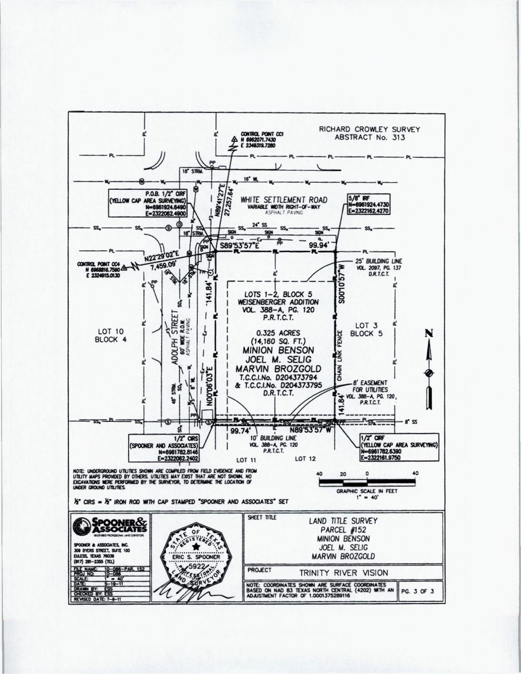
8 21. The Board of Directors recessed for a break from 11:46 a.m. to 12 noon. 22. The presiding officer next called an executive session at 12 noon under V.T.C.A., Government Code, Section to consult with legal counsel on a matter in which the duty of counsel under the Texas Disciplinary Rules of Professional Conduct clearly conflicts with Chapter 551, Texas Government Code; to conduct a private consultation with attorneys regarding pending or contemplated litigation; and under Section to deliberate the purchase, exchange, lease or value of real property. the meeting. 23. Upon completion of the executive session at 12:13 p.m., the President reopened 24. With the recommendation of management, Director Sparks moved to approve the purchase of the following described land necessary for the public purpose and use of construction of the Trinity River Vision - Central City Project, including for use as a staging area during construction, from Minion Benson, Joel M. Selig and Marvin Brozgold for the negotiated purchase price of $217, Funding for this purchase is included in the FY 2011 General Fund. Fee simple to the surface estate only of approximately acres of land, including improvements, being Lots 1 and 2, Block 5, Weisenberger Addition to the City of Fort Worth, Tarrant County, Texas; according to plat recorded in Volume 388-A, Page 120, Deed Records of Tarrant County, Texas; owned by Minion Benson, Joel M. Selig and Marvin Brozgold, said tract being more particularly described by metes and bounds on the survey plat attached hereto as Exhibit "A".

9 Page: 1 of 3 LEGAL DESCRIPTION PARCEL 152 BKING a trad of land situated in the Richard Crowley Survey. Abstract No. 313, City of Fort Worth, Tarrant County. Texas and being all of that certain tract of land conveyed to MINION BENSON, JOEL M. SELIG and MARVIN BROZGOLD by deeds as recorded in Tarrant County Clerk's Instrument Numbers (T.C.C.I.No.) D and D , Deed Records. Tarrant County. Texas (D.R.T.C.T.). said tract being all of Lots I -2. Block 5. Weisenbcrger Addition, being an addition to the City of Fort Worth. Tarrant County. Texas according to the plat thereof recorded in Volume 388-A, Page 120, Plat Records. Tarrant County. Texas (P.R.T.C.T.). said tract being herein more particularly described by metes and bounds as follows: BEGINNING at a '/i" iron rod with yellow cap stamped "AREA SURVF.Y1NG" found at the northwest property corner of the said Block 5, said beginning point being at the intersection of the east right-of-way line of Adolph Street Street, being a 60' wide right-of-way. with the south right-of-way line of White Settlement Road, being a variable width right-of-way; THENCE South 89'53'57" East, along the north property line of the said Block 5 and along the said south right-of-way line of White Settlement Road, feet to a 5/8" iron rod found at the northeast property corner of the said Lot 2. same being the northwest property corner of Lot 3. Block 5 of the said Weiscnberger Addition; THENCE South 00 IO*57" West, along the east property line of the said Lot 2 and along the west property line of the said Lot feet to a W iron rod with yellow cap stamped "AREA SURVEYING" found at the southeast property corner of the said Lot 2. same being the northeast property corner of Lot 12. Block 5 of the said Weisenbcrger Addition; THENCE North 89 53'57" West, along the south property lines of the said Lots I -2 and along the north property lines of Lots 11-12, Block 5 of the said Weiscnberger Addition feet to a '/J" iron rod with cap stamped "SPOONKR AND ASSOCIATES" set (1/2" CIRS) at the southwest property corner of the said Lol 1. same being on the said cast right-of-way line of Adolph Street; THENCE North 00"06'03" East, along the west property line of the said Lot I and along the said east right-of-way line of Adolph Street feet to the POINT OK BEGINNING; The tract being herein described contains 0325 acres (14,160 square feet) of land. Note: Survey sketch to accompany this legal description. Note: Basis of Bearing = NAD 83 Texas North Central Zone (4202) Note: Coordinates shown are surface coordinates based on NAD 83 Texas North Central Zone (4202) with an adjustment factor of I do certify on this I9' h day of May that a survey was made on the ground as per the field notes shown on this survey and is true and correct according to the standards of the Texas Society of Professional Surveyors Standards and Specifications for a Category 1 A, Condition II Survey, and accurate as to the boundaries and areas of the subject property and the size, location and type of
10 Page: 2 of 3 buildings and improvement! located within five (5) feet of said boundaries, if any, and shows the location of all visible casements and rights-of-way and the rights-of-way. casements and other matters of record as listed in Schedule B of the Commitment for Title issued by Alliant National Title Insurance Company. Dated May with an effective date of May 5, GF* affecting the subject property. Except as shown on the survey: (i) there are no visible encroachments upon the subject property by visible improvements on adjacent property. (ii) there are no visible encroachments on adjacent property, streets or alleys by any visible improvements on the subject property, and (iii) there arc no visible conflicts or discrepancies The property adjoins Adolph Street, a 60 feet wide right-of-way and While Settlement Road, a variable width right-of-way. both of which provide apparent access to and from the subject property. This survey substantially complies with the current Texas Society of Professional Surveyors Standards and Specifications for a Category I A. Condition II Survey. By: Spooner and Associates. Inc. or S/-' f*-^ fc % ERIC S. SPOONER Surveyors Nome: Eric S. Spooner RegisteredTrofcssional Land Surveyor. Texas No Date of Survey: II Revised Owners Name: \ % 5922 / s vrm< ^^8*
11
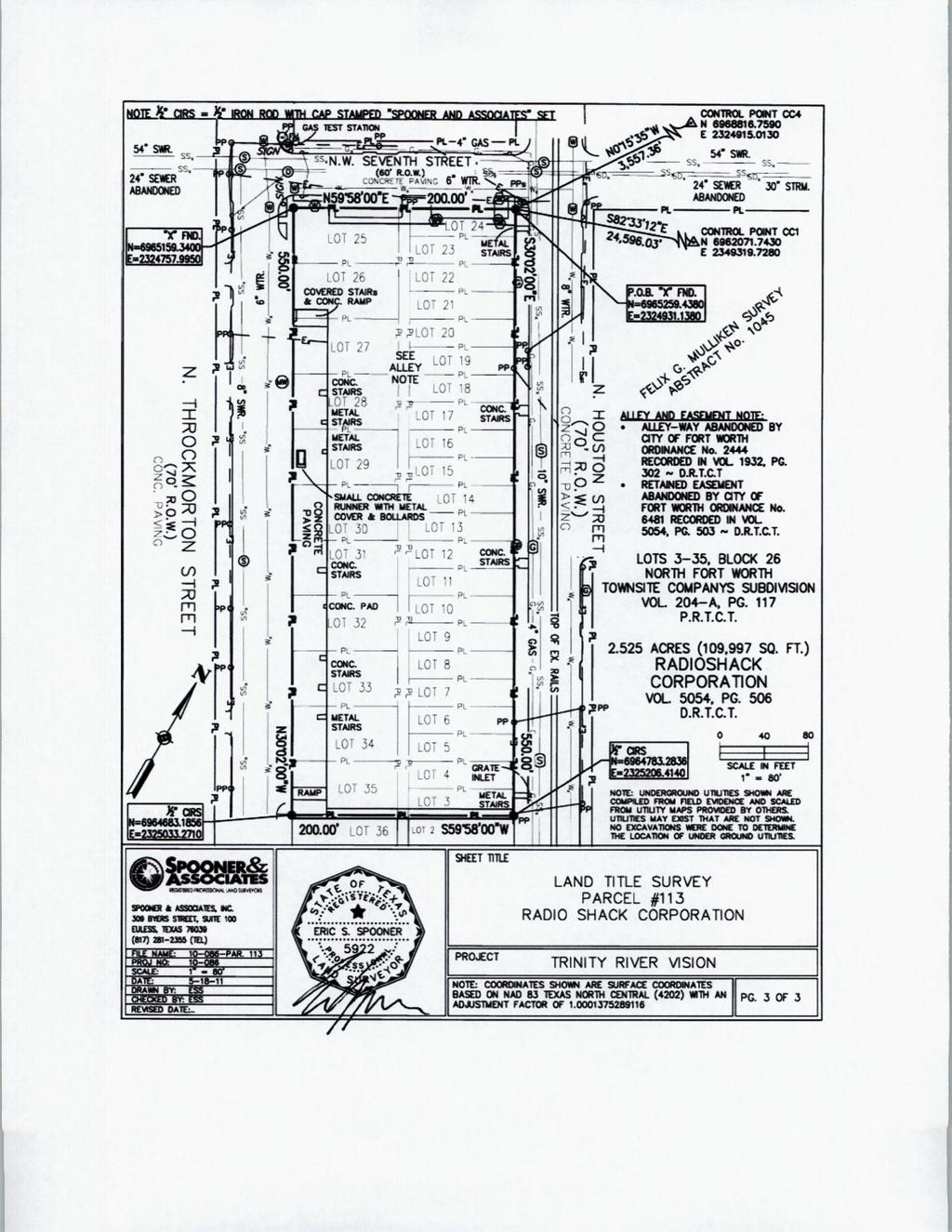
12 In addition, R. Steve Christian is granted authority to execute all documents necessary to complete this transaction and to pay all reasonable and necessary closing and related costs incurred with this acquisition. Director Stevens seconded the motion and the vote in favor was unanimous. 25. With the recommendation of management and the Board of Directors of Trinity River Vision Authority at its meeting on June 1, 2011, Director Stevens moved to approve the acquisition of the following described real property for the public purpose and use of construction of the Trinity River Vision - Central City Project, including portions needed for use as a staging area during construction, whether by eminent domain or by purchase. Funding for this acquisition is included in the FY 2011 General Fund. Fee simple title to the surface estate only, including improvements located thereon, of approximately acres of land, including improvements, being Lots 3-35, Block 26, North Fort Worth Townsite Companys Subdivision, an Addition to the City of Fort Worth, Tarrant County, Texas; according to plat recorded in Volume 204-A, Page 117, Deed Records of Tarrant County, Texas; TOGETHER WITH the alley adjacent to said Lots 3 through 35 abandoned by City of Fort Worth Ordinance Nos and 6481, certified copies of said ordinances being filed for record in Volume 1932, Page 302, and in Volume 5054, Page 503, Deed Records of Tarrant County, Texas, owned by RadioShack Corporation said tract being more particularly described by metes and bounds on the survey plat attached hereto as Exhibit "A".
13 Page: I of 3 LEGAL DESCRIPTION PARCEL 113 BEING a iraei of land situated in the Felix G. Mulliken Survey. Abstract No. I()45, City of Fort Worth. Tarrant County. Texas and being all of that certain tract of land conveyed to RADIOSHACK CORPORATION by deed as recorded in Volume Page 506, Deed Records, Tarrant County. Texas (D.R.T.C.T.). said tract being all of Lots Block 26. North Fort Worth Townsitc Companys Subdivision, being an addition to the City of Fort Worth. Tarrant County. Texas according to the plat thereof recorded in Volume 204-A. Page 117. Plat Records. Tarrant County. Texas (P.R.T.C.T.). and together w ith the alley adjacent to said Lots 3-35 abandoned by City of Fort Worth Ordinance Numbers 2444 and certified copies of said ordinances being filed for record in Volume Page 302 and in Volume Page 503, D.R.T.C.T.. said tract being herein more particularly described by metes and bounds as follows: BEGINNING at a "X" cut in concrete found at the north property comer of the said Block 26. said beginning point being at the intersection of the southwest right-of-way line of North Houston Street, being a 70* wide right-of-way at this point, with the southeast right-of-way line of North West Seventh Street, being a 60' wide right-of-way at this point; THENCE South 30 02'00" Hast, along the northeast property line of the said Block 26 and along the said southwest right-of-way line of North Houston Street feet to a W iron rod with cap stamped "SPOONER AND ASSOCIATES" set (1/2" CIRS) at the east property corner of the said Lot 3. Block 26, same being the north property comer of Lot 2. Block 26 of the said North Fort Worth Townsitc Companys Subdiv ision; THENCE South 59*58*00" West, along the southeast property line of the said Lots 3 and 35. Block 26. along the northwest property line of the said Lot 2 and along the northwest property line of Lot 36. Block 26 of the said North Fort Worth Townsile Companys Subdivision feet to a W CIRS at the south property comer of the said Lot 35. same being the west property comer of the said IXH 36. said W CIRS being on the northeast right-of-way line of North Throckmorton Street, being a 70' wide right-of-way al this point; THENCE North 30 02'00" West, along the southwest property line of the said Block 26 and along the said northeast righl-of-way line of North Throckmorton Street feet 10 a "X" found in concrete at the west properly corner of the said Block 26. same being on the said southeast right-of-way line of North West Seventh Street; THENCE North 59'58*00" East, along the northwest property line of the said Block 26 and along the said southeast righl-of-way line of North West Seventh Street feet to the POINT OF BEGINNING; The tract being herein described contains 2^25 acres (109,997 square feet) of land. Note: Survey sketch to accompany this legal description Note: Basis of Bearing = NAD 83 Texas North Central Zone (4202)
14 Page: 2 of 3 Noie: Coordinates shown aa* surface coordinates based on NAD 83 Texas Nonh Central Zone (4202 > with an adjustment factor of I.OOOI I do certify on this I8 lh day of May that a survey was made on the ground as per the field notes shown on this survey and is true and correct according to the standards of the Texas Society of Professional Surveyors Standards and Specifications for a Category I A. Condition II Survey, and accurate as to the boundaries and areas of the subject property and the size, location and type of buildings and improvements located within five (5) feel of said boundaries, if any. and shows the location of all visible casements and rights-of-way and the rights-of-way. easements and other matters of record as listed in Schedule B of the Commitment for Title issued by Allium National Title Insurance Company. Dated May with an effective date of May , GF# affecting the subject property. Except as shown on the survey: (i) there are no visible encroachments upon the subject property by visible improvements on adjacent property, (ii) there are no visible encroachments on adjacent property, streets or alleys by any visible improvements on the subject property, and (iii) there are no visible conflicts or discrepancies. The property adjoins North West Seventh Street, a 70 feet wide right-of-way. North Houston Street, a 70' right-of-way and North Throckmorton Street, a 70 feet w ide right-of-way. all of which provide apparent access to and from the subject property. This survey substantially complies with the current Texas Society of Professional Surveyors Standards and Specifications lor a Category I A. Condition II Survey. By: Spooncr ajjdrasspciatcs. Inc. 7 t * ;-, Surveyors Nsofe: Eric S. Sp<x>ner < ^ ERIC S. SP00NER ^ > / Registered Professional I.and Surveyor. L<^ r t S5 *o** 0<*y Texas No sur^v* Date of Survey:
15
16 In addition, R. Steve Christian, Real Property Director, and the staff of the Water District are hereby authorized to commence eminent domain proceedings to acquire the property; and authorized to take all steps which are reasonably necessary to facilitate the acquisition of the above-described property, whether by eminent domain or by purchase, and in connection therewith to pay all reasonable and necessary costs incurred with such acquisition. Director Sparks seconded the motion and the vote in favor was unanimous. 26. With the recommendation of management and the Board of Directors of Trinity River Vision Authority at its meeting on June 1, 2011, Director Leonard moved to approve the acquisition of the following described real property for the public purpose and use of construction of the Trinity River Vision - Central City Project, including portions needed for use as a staging area during construction, whether by eminent domain or by purchase. Funding for this acquisition is included in the FY 2011 General Fund. Fee simple title to the surface estate only, including improvements located thereon, of acres of land located in the J. BAUGH SURVEY, Abstract No. 115, the R. CROWLEY SURVEY, Abstract No. 313, the A. GOUHENANT SURVEY, Abstract No. 582, and the F.G. MULLIKEN SURVEY, Abstract No. 1045, Tarrant County, Texas, and being all of the tract of land designated as Second Parcel in the deed to MMM Group, LLC, recorded in Volume 14389, Page 63 of the Deed Records of Tarrant County, Texas, and a portion of the tract of land designated as First Parcel in such deed, and further described on the survey plat attached hereto as Exhibit "A-1". Fee simple title to the surface estate only, including improvements located thereon, of acres of land located in the A. GOUHENANT SURVEY, Abstract No. 582, Fort Worth, Tarrant County, Texas, and being a portion of the tract of land designated as First Parcel in the deed to MMM Group, LLC, by the deed recorded in Volume 14389,
17 Page 63 of the Deed Records of Tarrant County, Texas said tract being more particularly described in the accompanying resolution and in the survey plat for Parcel #166 attached thereto as Exhibit "A- 2". Fee simple title to the surface estate only, including improvements located thereon, of acres of land located in the J. BAUGH SURVEY, Abstract No. 115, Fort Worth, Tarrant County, Texas, and being a portion of the tract of land designated as First Parcel in the deed to MMM Group, LLC, by the deed recorded in Volume 14389, Page 63 of the Deed Records of Tarrant County, Texas said tract being more particularly described in the accompanying resolution and in the survey plat for Parcel #170 attached thereto as Exhibit "A- 3". Said Property as represented on Exhibits A-1 through A-3 being all of the land conveyed to MMM Group, LLC, by instrument recorded in Volume 14389, Page 63 of the Deed Records of Tarrant County, Texas.
18 Page: I of 8 PARCELS #111,165,166 & 170 LEGAL DESCRIPTION BEING acres of land located in the J. BAUGH SURVEY, Abstract No. 115, the R. CROWLEY SURVEY, Abstract No 313, the A. GOUHENANT SURVEY, Abstract No. 582, the F.G. MULLIKEN SURVEY, Abstract No of Tarrant County, Texas, and being all of the tract of land designated as Second Parcel in the deed to MMM Group, LLC, recorded in Volume 14389, Page 63 of the Deed Records of Tarrant County, Texas (D.R.T.C.T.), and a portion of the tract of land designated as First Parcel in the aforesaid deed to MMM Group, LLC. Said acres of land being more particularly described by metes and bounds, as follows: BEGINNING at a 2" iron pipe found, in the common line between the aforesaid J. BAUGH SURVEY, and the R. CROWLEY SURVEY, and lying feet, Westerly from the Southeast comer of the aforesaid J. BAUGH SURVEY; THENCE N 45' 18' 57* W feet, along the Northeast boundary line of the Tarrant County Water Control and Improvement Distnct No. 1 Tract, recorded in Volume Page 509 of the D.R.T.C.T., to a 1/2" iron rod stamped "Brittain & Crawford" set in the Southeast right-of-way line of the Fort Worth & Western Railroad right-of-way; THENCE along the Southeast right-of-way line of said Fort Worth & Western Railroad right-of-way, as follows: THENCE 1. N 22' 17' 38" E feet, to a 1/2* iron rod stamped "Brittain & Crawford" set, at the beginning of a curve to the left; 2. NORTHEASTERLY feet, along said curve to the left having a radius of feet, a central angle of 18' 12' 49", and a chord bearing N 13' 11' 13" E feet, to a 1/2" iron rod stamped "Brittain & Crawford" set at the end of said curve; 3. N 04' 04' 48" E feet, to a 5/8" iron rod stamped "TranSystems" found, at the intersection of said Southeast right-of-way line of said Fort Worth & Western Railroad right-of-way, and the Northwest nghtof-way line of Ihe St Louis, Arkansas & Texas Railway Company right-of-way recorded in Volume 56, Page 533, D.R.T.C.T.; along the Northwest right-of-way line of said St. Louis, Arkansas & Texas Railway Company right-of-way, as follows: 1. SOUTHEASTERLY feet, along a curve to the left having a radius of feet, a central angle of 49* 40' 51". and a chord bearing S 20' 45' 37" E feet, to a 5/8" iron rod stamped "TranSystems" found, at the end of said curve; 2. S 45" 36' 03" E feet, to a found railroad rail for a corner. Said point lying in the North line of a Tract conveyed to St. Louis, Arkansas & Texas Railway Company by the deed recorded in Volume 48, Page 127 of the D.R.T.C.T.; THENCE S 44' 35' 47" W feet, along the North line of said St. Louis, Arkansas & Texas Railway Company Trad, to a "PK" nail found, in the East boundary line of the Tract of land conveyed to Tarrant County Water and Improvement District No. 1 by the deed recorded in Volume 2313, Page 509 of the D.R.T.C.T.; <j FWMtOianQ PV«< II -III-IM-I6»-ITO««
19 Paye 2 of8 THENCE THENCE N 58" 45' 57" W feet, along the Northeast boundary line of said Tarrant County Water and Improvement District No. 1 Tract, to a 1/2" iron rod stamped "Brittain & Crawford' set; N 45 18' 57" W continuing along the Northeast line of said Tarrant County Water Control and Improvement District No. 1 Tract, at feet, passing a 1/2" iron rod marked "Brittain & Crawford" set, in all feet, to THE PLACE OF BEGINNING, containing acres or (299,490 square feet) of land. Note: Survey sketch to accompany this legal description. Note: Basis of bearing = NAD 83 Texas North Central Zone (4202). Note: Coordinates shown are surface coordinates based on NAD 83 Texas North Central Zone (4202) with an adjustment factor of I do hereby certify on this 11th day of September, 2009, that a survey was made on the ground as per the field notes shown on this survey and is true and correct according to the standards of the Texas Society of Professional Surveyors Standards and Specifications for a Category 1A, Condition II Survey, and accurate as to the boundaries and areas of the subject property and the size, location and type of buildings and improvements located within five (5) feet of said boundaries, if any, and shows the location of all visible easements and rights-of-way and the rights-of-way, easements, and other matters of record as listed in Schedule B of the Commitment for Title issued by Lawyers Title Insurance Company, Dated July 30, 2009, GF# TPWB affecting the subject property, and the location of all curb cuts and driveways, if any Except as shown on the survey: (i) there are no visible encroachments upon the subject property by visible improvements on adjacent property, (ii) there are no visible encroachments on adjacent property, streets or alleys by any visible improvements on the subject property, and (iii) there are no visible conflicts or discrepancies. The subject property does not abut any public right-of-way, and has no apparent public access to or from the subject property. This survey substantially complies with the current Texas Society of Professional Surveyors Standards and Specifications for a Category 1A, Condition II Survey. By: Brittain & Crawford Land Surveying & Topographic Mapping AtWLto (^jqclteta^j^ James L. Brittain Registered Professional I.and Surveyor No Brut i/w \% 1674~ r Dated: , f.i... -:.\ - I I ' 11 l,.j!',(.,1>;
20 CRAPHiC SCALE IN FEET BRITTAIN * CRAWFORD LAND SCmtYINC» Twoaupwe MAPPING SHEET TITLE PROJEC" LANO TITLE SURVET MM C30UP PARCELS Milt 165, 166 & 170 PKU HO: P?«Q» mm m jtmgwt:: b-- <#im a*: «.p.i. tlyisfo: UPKIHR QW< «. 70O9 TRINITY RIVFR VISION NOIC: COWOlHAlfS SMOM MC Suef»Cf COOBOIHAUS
21
22
23
24
25
26 Page: 1 of 3 PARCEL #166 LEGAL DESCRIPTION BEING acres of land located in the A. GOUHENANT SURVEY, ABSTRACT NO. 582, Fort Worth, Tarrant County, Texas, and being a portion of the tract of land designated as First Parcel in the deed to MMM Group.. LLC, by the deed recorded in Volume 14389, Page 63 of the Deed Records of Tarrant County, Texas. Said acres of land being more particularly described by metes and bounds as follows: BEGINNING at a 1" iron pipe found in the West boundary line of said First Parcel, being the West boundary line of said GOUHENANT SURVEY, and the East boundary line of the R. CROWLEY SURVEY, ABSTRACT NO and said POINT OF BEGINNING being located feet South of the Northwest comer of said GOUHENANT SURVEY, and said POINT OF BEGINNING also lying at the Northwest corner of the Right-of-Way tract designated as 3 rd Tract in the deed to Fort Worth Improvement District No. 1 of Tarrant County, Texas, recorded in Volume 383, Page 22 of the Deed Records of Tarrant County, Texas, THENCE along the Northeast boundary line of said 3 rd Tract (Right-of-Way), as follows: 1. S 45 18' 57" E feet, to a Vf iron rod marked "Brittain & Crawford; set; THENCE 2. S 58 45' 57" E feet, to a P.K. Nail found at the East comer of said 3 rd Tract, lying in the Northwest boundary line of the tract of land conveyed to St. Louis Southwestern Railroad Company by the deed recorded in Volume 48, Page 127 of the Deed Records of Tarrant County, Texas; S 44 30' 03" W feet, along the Southeast boundary line of said 3* Tract (Right-of-Way), and the Northwest boundary line of said St. Louis Southwestern Railroad Company Tract, to a point in the Northeast low top bank of the West Fork of the Trinity River, being the South corner of said 3 rd Tract (Right-of-Way); THENCE along the Southwest boundary line of said 3 rd Tract (Right-of-Way), and the Northeast low top bank of the Trinity River, as follows: 1. N 55 47' 33" W feet, to a point; 2. N 48 23'57" W feet, to a point; 3. N 39 31' 52* W feet, to a point; 4. N 35 17' 52' W feet, to a point; 5. N 33 15'09* W feet, to a point; 6. N 36 30' 18" W feet, to a point in the West boundary line of aforesaid A. GOUHENANT SURVEY, and the Southwest comer of said 3 rd Tract (Right-of-Way); THENCE N 0 00' 21" W feet, along the West boundary line of said GOUHENANT SURVEY, the West boundary line of aforesaid First Parcel to MMM Group, LLC, and the West boundary line of said 3 rd Tract (Right-of-Way), to the POINT OF BEGINNING containing acres or (207,820 Sq. Ft.) of land. (. lulliiomharo M M T1M.OK
27 Page: 2 of 3 Note: Survey sketch to accompany this legal description Note: Basis of bearing = NAD 83 Texas North Central Zone (4202). Note: Coordinates shown are surface coordinates based on NAD 83 Texas North Central Zone (4202) with an adjustment factor of I do hereby certify on this 3rd day of August that a survey was made on the ground April 28, 2008 as per the field notes shown on this survey and is true and correct according to the standards of the Texas Society of Professional Surveyors Standards and Specifications for a Category 1A, Condition II Survey and accurate as to the boundaries and areas of the subject property and the size, location and type of buildings and improvements located within five (5) feet of said boundaries, if any, and shows the location of all visible easements and rights-of-way and the rights-of-way. easements, and other matters of record as listed in Schedule B of the Commitment for Title issued by Lawyers Title Insurance Company, Dated July 30, 2009, GF# TPWB affecting the subject property, and the location of all curb cuts and driveways, if any. Except as shown on the survey: (i) there are no visible encroachments upon the subject property by visible improvements on adjacent property, (ii) there are no visible encroachments on adjacent property, streets or alleys by any visible improvements on the subject property, and (iii) there are no visible conflicts or discrepancies. The subject property does not abut any public right-of-way, and has no apparent public access to or from the subject property. This survey substantially complies with the current Texas Society of Professional Surveyors Standards and Specifications for a Category 1A, Condition II Survey. By: Brittain & Crawford Land Surveying & Topographic Mapping /jattuol $*U<ZZs<JL^ L^James L. Brittain Registered Professional Land Surveyor No Xy^rC'--* < U f r ^. S f M v U H I I lt*»«
28 C*CR 0 BT: K.D.E. --I.f NAVF: P'W.V-WOOCI NOTE: CMHOINAIES SH0»N WE SURFACE C00R0INA1ES BASED ON NAD Si TtJAS NORTH CEN1RAL ZONE «?<«) VITN AN AOJUSlMfN! FACTOR OF mlU PC. 1 Of 3
29 Page: 1 of 3 PARCEL #170 LEGAL DESCRIPTION BEING acre of land located In the J. BAUGH SURVEY, ABSTRACT NO. 115, Fort Worth, Tarrant County, Texas, and being a portion of the tract of land designated as First Parcel in the deed to MMM Group, LLC, by the deed recorded in Volume Page 63 of the Deed Records of Tarrant County, Texas. Said acres of land being more particularly described by metes and bounds as follows: BEGINNING at a 1' iron pipe found in the most Northerly South boundary line of said First Parcel, being the South boundary line of said J. BAUGH SURVEY, and said POINT OF BEGINNING being located feet West of the Southeast comer of said J. BAUGH SURVEY, and said POINT OF BEGINNING also being the East comer of the Right-of-Way Tract of land designated as 4* Tract in the deed to Fort Worth Improvement District No. 1 of Tarrant County, Texas, recorded in Volume 383, Page 22 of the Deed Records of Tarrant County. Texas; THENCE THENCE THENCE N 89 24' 11" W feet, along the most Northerly South boundary line of said First Parcel, and the South boundary line of said 4* Tract (Right-of-Way), to a Vf capped iron rod set stamped Brittain & Crawford at the Southwest corner of said 4* Tract (Right-of-way), and the most Westerly Southwest corner of said First Parcel, lying in the Southeast right-of-way line of the St. Louis San Francisco & Texas Rail Road Co.; N 22 17' 38" E feet, along the Southeast right-of-way line of said railroad, and the Northwest boundary line of said First Parcel, and the Northwest boundary line of said 4 lh Tract (Right-of-Way), to a W iron rod found at the North corner of said 4* Tract (Right-of-Way); S 45 18' 57" E feet, along the Northeast boundary line of said 4* Tract (Right-of-Way). to the POINT OF BEGINNING containing aae or (13,269 Sq. Ft.) of land. Note: Survey sketch to accompany this legal description. Note: Basis of bearing = NAD 83 Texas North Central Zone (4202). Note: Coordinates shown are surface coordinates based on NAD 83 Texas North Central Zone (4202) with an adjustment factor of li ihra l?m <unrt V\I< H. I-IKIK
30 Page: 2 of 3 I do hereby certify on this 3rd day of August that a survey was made on the ground April as per the field notes shown on this survey and is true and correct according to the standards of the Texas Society of Professional Surveyors Standards and Specifications for a Category 1A Condition II Survey, and accurate as to the boundaries and areas of the subject property and the size, location and type of buildings and improvements located within five (5) feet of said boundaries, if any, and shows the location of all visible easements and rights-of-way and the rights-of-way, easements, and other matters of record as listed in Schedule B of the Commitment for Title issued by Lawyers Title Insurance Company. Dated July 30, 2009, GF# TPWB affecting the subject property, and the location of all curb cuts and driveways, if any. Except as shown on the survey: (i) there are no visible encroachments upon the subject properly by visible improvements on adjacent property, (ii) there are no visible encroachments on adjacent property, streets or alleys by any visible improvements on the subject property, and (iii) there are no visible conflicts or discrepancies. The subject property does not abut any public right-of-way, and has no apparent public access to or from the subject property This survey substantially complies with the current Texas Society of Professional Surveyors Standards and Specifications for a Category 1A, Condition II Survey By: Brittain & Crawford Land Surveying & Topographic Mapping L SAZ&ZU^ James L. Brittain Registered Professional I.and Surveyor No V&tZSAt&JI <. win > MKUVHMN
31 cnt*»j'= ' ; > MM: PI?:.-P5CO-.- NOTE: COOROIMTES SMO»K *<* SlMMCE COWCIMUS 84SE0 ON NAD 8} TfMS NORTH CENTRAL K M (4?0?) (ITM»N»0Jlrt?l*Nl f ACTOR Of ?5?$9I16 PC. 3 O* 3
32 In addition, R. Steve Christian, Real Property Director, and the staff of the Water District are hereby authorized to commence eminent domain proceedings to acquire the property; and authorized to take all steps which are reasonably necessary to facilitate the acquisition of the above-described property, whether by eminent domain or by purchase, and in connection therewith to pay all reasonable and necessary costs incurred with such acquisition. Director Stevens seconded the motion and the vote in favor was unanimous. 27. With the recommendation of management and General Counsel, Director Sparks moved to approve a Settlement Agreement of the claims of Seley Johnson Fuller and Sam Byron Hulsey, individually and as trustee of the trust created pursuant to the Last Will and Testament of Linda Johnson Hulsey, Deceased (the distributee and heir of the distributee of the Luther Johnson Testamentary Trust) in the amount of $20,000 and Charles Irvine in the amount of $30,000 in the Montgomery Lawsuit. Funding for this settlement is included in the Bond Fund. Director Leonard seconded the motion and the vote in favor was unanimous. 28. There being no further business before the Board of Directors, the meeting was adjourned. y-^dicr President C^^rlJjL-v ^LLX^L
MINUTES OF A MEETING OF THE BOARD OF DIRECTORS OF TARRANT REGIONAL WATER DISTRICT HELD ON THE 20 DAY OF JULY 2004 AT 9:30 A.M.
 MINUTES OF A MEETING OF THE BOARD OF DIRECTORS OF TARRANT REGIONAL WATER DISTRICT HELD ON THE 20 DAY OF JULY 2004 AT 9:30 A.M. The call of the roll disclosed the presence of the Directors as follows: Present
This Agenda is posted pursuant to Chapter 551, Texas Government Code
 This Agenda is posted pursuant to Chapter 551, Texas Government Code MATTERS TO COME BEFORE A MEETING OF THE BOARD OF DIRECTORS OF TARRANT REGIONAL WATER DISTRICT TO BE HELD THE 21ST DAY OF JANUARY 2014
Present Jack Stevens Marty Leonard Jim Lane Leah King James Hill
 MINUTES OF A MEETING OF THE BOARD OF DIRECTORS OF TARRANT REGIONAL WATER DISTRICT HELD ON THE 15th DAY OF FEBRUARY 2018 AT 9:00 A.M. The call of the roll disclosed the presence of the Directors as follows:
This Agenda is posted pursuant to Chapter 551, Texas Government Code
 This Agenda is posted pursuant to Chapter 551, Texas Government Code Matters to Come Before a Meeting of the Board of Directors of Tarrant Regional Water District To Be Held the 15th Day of March 2016
This Agenda is posted pursuant to Chapter 551, Texas Government Code
 This Agenda is posted pursuant to Chapter 551, Texas Government Code Matters to Come Before a Meeting of the Board of Directors of Tarrant Regional Water District To Be Held the 15th Day of December 2015
Perkins; Laura Alexander of Hilltop Securities; Molly
 MINUTES OF A MEETING OF THE BOARD OF DIRECTORS OF TARRANT REGIONAL WATER DISTRICT HELD ON THE 16th DAY OF JANUARY 2018 AT 9:00 A.M. The call of the roll disclosed the presence of the Directors as follows:
MINUTES OF A MEETING OF THE BOARD OF DIRECTORS OF TARRANT REGIONAL WATER DISTRICT HELD ON THE 2Qth DAY OF MARCH 2018 AT 9:00 A.M.
 MINUTES OF A MEETING OF THE BOARD OF DIRECTORS OF TARRANT REGIONAL WATER DISTRICT HELD ON THE 2Qth DAY OF MARCH 2018 AT 9:00 A.M. The call of the roll disclosed the presence of the Directors as follows:
This Agenda is posted pursuant to Chapter 551, Texas Government Code
 This Agenda is posted pursuant to Chapter 551, Texas Government Code Matters to Come Before a Meeting of the Board of Directors of Tarrant Regional Water District To Be Held the 16th Day of February 2016
The City Council of the City of Sulphur, Louisiana, met in special session at its
 July 12, 2018 The City Council of the City of Sulphur, Louisiana, met in special session at its regular meeting place in the Council Chambers, Sulphur, Louisiana, on July 12, 2018 at 5:00 p.m., after full
$5,462 ($3,762, plus closing costs not to exceed
 4: Q i Jtwié9,21O A RESOLUTION DETERMINING UPON THE NECESSITY OF ACQUIRING REAL PROPERTY AND AUTHORIZING ITS APPROPRIATION AND/OR CONDEMNATION FOR A MUNICIPAL PURPOSE AND PUBLIC USE. DEFINITIONS: shall
Avg. HH Income th Avenue Fort Worth, TX
 Site Available Southwest Corner of Old Decatur Road & W.J. Boaz Road PROPERTY SPECIFICATIONS: LOCATION: LAND SIZE: Southwest corner of Old Decatur Road & W.J. Boaz Road Approximately 1.46 Acres SITE ZONED:
A portion of the land (surplus land), described in Exhibit A, is no longer needed for a state highway purpose.
, described in Exhibit A, is no longer needed for a state highway purpose.") TEXAS TRANSPORTATION COMMISSION DENTON County MINUTE ORDER Page 1 of 2 DALLAS District In the city of Northlake, DENTON COUNTY, on INTERSTATE 35W, the State of Texas (state) acquired certain land for a
TEXAS TRANSPORTATION COMMISSION DENTON County MINUTE ORDER Page 1 of 2 DALLAS District In the city of Northlake, DENTON COUNTY, on INTERSTATE 35W, the State of Texas (state) acquired certain land for a
Honorable Mayor Bill Agan and members of the Richland Hills City Council. Final Plat Richland Hills, Lots 1 & 2, Block 1 Brumlow Addition
 2B - 1 Memorandum To: From: Date: Subject: Honorable Mayor Bill Agan and members of the Richland Hills City Council Jason Moore, Assistant City Manager January 17, 2017 Final Plat Richland Hills, Lots
WATERFORD LANDING COMMUNITY DEVELOPMENT DISTRICT REGULAR MEETING AGENDA
 WATERFORD LANDING COMMUNITY DEVELOPMENT DISTRICT REGULAR MEETING AGENDA January 31, 2019 Waterford Landing Community Development District OFFICE OF THE DISTRICT MANAGER 2300 Glades Road, Suite 410W Boca
Department of Development Services Engineering; Survey Plat Review Group SPRG
 Department of Development Services Engineering; Survey Plat Review Group SPRG CITY OF DALLAS LEGAL DESCRIPTION PREPARATION GUIDELINE AND CHECKLIST The following guideline and checklist are provided to
SUPPLEMENTAL TITLE REPORT
 70 SW Third Ave., Ontario, OR 97914 PHONE (541)889-6451 FAX (541)889-4161 October 4, 2017 File Number: 199652AM Report No.: 2 Title Officer: Mike Malmberg SUPPLEMENTAL TITLE REPORT Property Address: 255
QUITCLAIM DEED CR 202 THE STATE OF TEXAS KNOW ALL MEN BY THESE PRESENTS: COUNTY OF WILLIAMSON
 QUITCLAIM DEED CR 202 THE STATE OF TEXAS KNOW ALL MEN BY THESE PRESENTS: COUNTY OF WILLIAMSON That WILLIAMSON COUNTY, TEXAS, hereinafter referred to as Grantor, whether one or more, for and in consideration
NOTICE OF FORECLOSURE SALE
 NOTICE OF FORECLOSURE SALE FILED TARRANT COUNTY TEXAS 2018 SEP 11 PH 3: ~9 Notice is hereby given of a public nonjudicial foreclosure sale. M R Lr l~ L ARCIA COUNTY Cl.ERK 1. Property To Be Sold. The property
For the purposes of this resolution, the following definitions of terms
 COUNCIL CHAMBER February 23, 2011 A RESOLUTION DETERMINING UPON THE NECESSITY OF ACQUIRING REAL PROPERTY AND AUTHORIZING ITS APPROPRIATION ANDIOR CONDEMNATION FOR A MUNICIPAL PURPOSE AND PUBLIC USE. DEFINITIONS:
Synergy Park Addition (Companion to item 3)
") Synergy Park Addition (Companion to item 3) Attachments: 1. Locator 2. Replat staff report 3. Replat W P G r es rg eo e s Bu hh wy Lot 6A 4.02-acres Lot 4C 13.02-acres Fran k Lots 4C and 6A, Block A Synergy
Synergy Park Addition (Companion to item 3) Attachments: 1. Locator 2. Replat staff report 3. Replat W P G r es rg eo e s Bu hh wy Lot 6A 4.02-acres Lot 4C 13.02-acres Fran k Lots 4C and 6A, Block A Synergy
COUNCIL AGENDA MEMO ITEM NO. III - #1
 COUNCIL AGENDA MEMO ITEM NO. III - #1 FROM: Anton Jelinek, Director of Utilities MEETING: October 24, 2017 SUBJECT: PRESENTER: Permanent Utility and Right-of-Way Easement Anton Jelinek Discussion: At the
DALLAS WATER UTILITIES WATER/WASTEWATER COVENANT
 DALLAS WATER UTILITIES WATER/WASTEWATER COVENANT Procedure for obtaining a water and wastewater covenant, water covenant, or wastewater covenant; Required for initial submittal: 1. One letter from the
WASTEWATER BACKFLOW RELEASE PROCEDURES
 WASTEWATER BACKFLOW RELEASE PROCEDURES PROCEDURE FOR OBTAINING A WASTEWATER RELEASE FOR PRIVATE DEVELOPMENT PROJECTS: PLEASE NOTE THAT THE WASTEWATER BACKFLOW RELEASE DOCUMENT MUST FOLLOW THE CITY S PROCEDURES.
Sketch & Legal Description of Mitigation Bank and Ingress/Egress Access Easements
 Appendix H: Sketch & Legal Description of Mitigation Bank and Ingress/Egress Access Easements Tippen Bay Wetland Mitigation Bank DeSoto County, Florida Prepared by: September, 2017 Original file
GeoPoint 1403 E. 5th Avenue Tampa, Florida
 AIRPORT ROAD PINELAND P.R.D. SUBDIVISION - PHASE 1 DEDICATION: CERTIFICATE OF REVIEW BY SURVEYOR, CITY OF ORMOND BEACH DEDICATION: THIS IS TO CERTIFY THAT FORESTAR (USA) REAL ESTATE GROUP INC., A DELAWARE
CITY OF OCALA CITY COUNCIL REPORT Council Meeting Date: 06/06/17
 CITY OF OCALA CITY COUNCIL REPORT Council Meeting Date: 06/06/17 Subject: Large Scale Land Use Map Amendment Submitted By: David Boston Department: Growth Management STAFF RECOMMENDATION (Motion Ready):
PLANNED DEVELOPMENT DISTRICT A ACRE TRACT KNOWN AS GEAN ESTATES CITY OF KELLER, TARRANT COUNTY TEXAS
 PLANNED DEVELOPMENT DISTRICT A 105.026 ACRE TRACT KNOWN AS GEAN ESTATES CITY OF KELLER, TARRANT COUNTY TEXAS A. Exhibit A Development Regulations B. Exhibit B Legal Description C. Exhibit C Conceptual
2. Policy (or Policies) to be issued: POLICY AMOUNT. a. ALTA Loan Policy (6/17/06) TBD
 to be issued: POLICY AMOUNT. a. ALTA Loan Policy (6/17/06) TBD") Schedule A 1. Commitment Date: February 24, 2015 at 08:00 AM 2. Policy (or Policies) to be issued: POLICY AMOUNT a. ALTA Loan Policy (6/17/06) TBD Proposed Insured: TO BE DETERMINED, its successors and/or
Schedule A 1. Commitment Date: February 24, 2015 at 08:00 AM 2. Policy (or Policies) to be issued: POLICY AMOUNT a. ALTA Loan Policy (6/17/06) TBD Proposed Insured: TO BE DETERMINED, its successors and/or
CERTIFIED SURVEY MAP
 SCONSIN STATE PLANE N:389676.12 E:2130390.15 Center of Section 23 CERTIFIED SURVEY MAP 734.06' THE (PRITCHETTE) ORIGINAL PLAT OF ALL IN THE NW 1 4 OF THE SE 1 4 OF FRACTIONAL SECTION 23, T7N, R9E, IN THE
-REQUESTED: Approve the Resolution of Necessity for the acquisition and condemnation of parcels required for the Matlacha Park Expansion Project.
 -REQUESTED: Approve the Resolution of Necessity for the acquisition and condemnation of parcels required for the Matlacha Park Expansion Project. WHY ACTION IS NECESSARY: The Board must formally approve
DEED AND DEDICATION FOR PUBLIC RIGHT OF WAY
 TO : BOARD OF DIRECTORS FROM : GARY PLATT, EXEC. DIRECTOR BUSINESS AND OPERATIONS SUBJECT : CITY OF STANWOOD CONSTRUCTION EASEMENT AND RIGHT-OF-WAY DEDICATION DATE : MARCH 17, 2009 TYPE : ACTION NEEDED
WHEREAS, the Petition was filed by PATRICK AND KIMBERLY SHULER for the vacation of plat on property described herein; and
 VP 15-0003 RESOLUTION 2-16 A RESOLUTION PROVIDING FOR THE VACATION OF PLAT FOR A PUBLIC UTILITY AND DRAINAGE EASEMENT UNDERLYING A PREVIOUSLY VACATED RIGHT-OF-WAY BEING A PART OF SW 28 PLACE ADJACENT TO
ORDINANCE N0.18-ll6. WHEREAS, City has prepared a Service Plan for said tract which is attached as Exhibit "A" to this ordinance; &
 c: 0 ORDINANCE N0.18-ll6 AN ORDINANCE ANNEXING THE HEREINAFTER DESCRIBED TERRITORY TO THE CITY OF FORT STOCKTON, PECOS COUNTY, TEXAS, AND EXTENDING THE BOUNDARY LIMITS OF SAID CITY SO AS TO INCLUDE SAID
CITY OF ALBERT LEA PLANNING COMMISSION ADVISORY BOARD
 CITY OF ALBERT LEA PLANNING COMMISSION ADVISORY BOARD 9/1/2015, 5:30 p.m. City Council Chambers AGENDA A. CALL TO ORDER AND ROLL CALL B. APPROVAL OF THE AGENDA C. APPROVAL OF MINUTES 1. PC Minutes from
ORDINANCE NO. CID-3087
 ORDINANCE NO. CID-3087 AN ORDINANCE MAKING FINDINGS AS TO THE NATURE AND ADVISABILITY OF CREATING A COMMUNITY IMPROVEMENT DISTRICT AT THE NORTHEAST CORNER OF 91 ST STREET AND METCALF AVENUE; CREATING SAID
AGENDA UPDATE ECONOMIC DEVELOPMENT & FINANCE STANDING COMMITTEE MEETING MONDAY, AUGUST 10, 2015 III. COMMITTEE AGENDA
 AGENDA UPDATE ECONOMIC DEVELOPMENT & FINANCE STANDING COMMITTEE MEETING MONDAY, AUGUST 10, 2015 III. COMMITTEE AGENDA REVISED ITEM NO. 4 150217.ORDINANCE: VACATION VILLAGE AREAS 1 AND 2A Synopsis: A revised
Village of Mantua, Ohio ORDINANCE
 AN ORDINANCE AUTHORIZING THE MAYOR TO EXECUTE A LEASE / OPTION TO PURCHASE AGREEMENT WITH THE PORTAGE PARK DISTRICT FOR THE HEADWATERS TRAIL WEST OF STATE ROUTE 44, AND DECLARING AN EMERGENCY. WHEREAS,
INVITATION FOR PROPOSALS SALE OF REAL PROPERTY INSTRUCTIONS, TERMS AND CONDITIONS
 INVITATION FOR PROPOSALS SALE OF REAL PROPERTY INSTRUCTIONS, TERMS AND CONDITIONS The City Council of the City of Covington invites members of the general public to submit sealed bid proposals to purchase
Present Jack Stevens Marty Leonard Leah King James Hill. Absent Jim Lane
 MINUTES OF A MEETING OF THE BOARD OF DIRECTORS OF TARRANT REGIONAL WATER DISTRICT HELD ON THE 15th DAY OF MAY 2018 AT 9:00 A.M. The call of the roll disclosed the presence of the Directors as follows:
PRELIMINARY TITLE SEARCH REPORT
 PRELIMINARY TITLE SEARCH REPORT Prepared By: Security 1 st Title 727 N. Waco, Suite 300 Wichita, KS 67203 Phone: (316) 267-8371 Fax: (316) 267-8115 Contact: David Herd Email: dherd@security1st.com Prepared
CONSENT ACTION BY THE BOARD OF DIRECTORS OF VENETO IN MIRAMAR CONDOMINIUM ASSOCIATION, INC.
 CONSENT ACTION BY THE BOARD OF DIRECTORS OF VENETO IN MIRAMAR CONDOMINIUM ASSOCIATION, INC. The undersigned, being all of the members of the Board of Directors of Veneto in Miramar Condominium Association,
David L. Brown, Construction Services Manager
 Memorandum Date: 2/02/2013 Order Date: 2/27/2013 TO: DEPARTMENT: PRESENTED BY: AGENDA ITEM TITLE: Board of County s Public Works David L. Brown, Construction Services Manager In the Matter of Authorizing
PLANNED DEVELOPMENT DISTRICT A ACRE TRACT KNOWN AS GEAN ESTATES CITY OF KELLER, TARRANT COUNTY TEXAS
 PLANNED DEVELOPMENT DISTRICT A 123.359 ACRE TRACT KNOWN AS GEAN ESTATES CITY OF KELLER, TARRANT COUNTY TEXAS A. Exhibit A Development Regulations B. Exhibit B Legal Description C. Exhibit C Conceptual
CONDITIONS OF SALE. The conditions of the present public sale are as follows:
 Prepare in duplicate. Post copy during sale and then give it to Purchaser. The conditions of the present public sale are as follows: CONDITIONS OF SALE 1. The property to be sold is a tract of improved
MEMORANDUM. Mayor and City Council. Warren Hutmacher, City Manager. Date: February 11, 2013
 MEMORANDUM To: From: Mayor and City Council Warren Hutmacher, City Manager Date: February 11, 2013 Subject: Approval of an Intergovernmental agreement by and between the City of Dunwoody and DeKalb County
to St. Louis County by deed recorded in Book 7954, Page 235 in the St. Louis County, Missouri
 Recommendation of Planning Commission BILL NO. 4032 ORDINANCE NO. 2015-3971 AN ORDINANCE ENACTING A CONDITIONAL USE PERMIT FOR AN ELECTRICAL SUBSTATION AT 11520 DORSETT ROAD Petition of Ameren Missouri)
LOCATION MAP SHEET 1 OF 10
 OWNER: ADDRESS: LOCATION MAP CENTURY LAND HOLDINGS II, LLC 6500 RIVER PLACE BLVD. BUILDING 2, SUITE 200 AUSTIN, TX 78730 OWNER: CITY OF LEANDER ADDRESS: P.O. BOX 319 LEANDER, TX 78646 ACREAGE: LOTS ACREAGE:
MEMORANDUM. Michael Smith, Director of Public Works. Discussion of Temporary Aerial Easement for KDC
 MEMORANDUM To: From: Mayor and City Council Michael Smith, Director of Public Works Date: August 11, 2014 Subject: Discussion of Temporary Aerial Easement for KDC ITEM DESCRIPTION Discussion of an aerial
ADDENDUM CITY COUNCIL MEETING AUGUST 22, 2001 CITY OF DALLAS 1500 MARILLA COUNCIL CHAMBERS, CITY HALL DALLAS, TEXAS :00 A.M.
 CITY OF DALLAS 1500 MARILLA COUNCIL CHAMBERS, CITY HALL DALLAS, TEXAS 75201 9:00 A.M. ADDITIONS: ITEMS FOR INDIVIDUAL CONSIDERATION 1. Authorize settlement of a claim filed by Wayne Love, Claim No. 95007750
[SPACE ABOVE THIS LINE FOR RECORDING INFORMATION]
![[SPACE ABOVE THIS LINE FOR RECORDING INFORMATION]](/thumbs/74/69889180.jpg "[SPACE ABOVE THIS LINE FOR RECORDING INFORMATION]") INSTRUMENT#: 2010398579, BK: 20216 PG: 1321 PGS: 1321-1326 11/23/2010 at 04:03:44 PM, DEPUTY CLERK:LPERTUIS Pat Frank,Clerk of the Circuit Court Hillsborough County ~l=~ntff~e' ~ F ~ E [] (~ 0 ~)) Y Donald
INSTRUMENT#: 2010398579, BK: 20216 PG: 1321 PGS: 1321-1326 11/23/2010 at 04:03:44 PM, DEPUTY CLERK:LPERTUIS Pat Frank,Clerk of the Circuit Court Hillsborough County ~l=~ntff~e' ~ F ~ E [] (~ 0 ~)) Y Donald
SOUND TRANSIT RESOLUTION NO. R99-11
 SOUND TRANSIT RESOLUTION NO. R99-11 A RESOLUTION of the Board of the Central Puget Sound Regional Transit Authority authorizing the Executive Director to acquire, dispose, or lease certain real property
GeoPoint 213 Hobbs Street Tampa, Florida
 AIRPORT ROAD PINELAND P.R.D. SUBDIVISION - PHASES 2 & 3 DESCRIPTION: A parcel of land lying in Sections 13 and 24, Township 14 South, Range 31 East, Volusia County, Florida, and being more particularly
Old Republic National Title Insurance Company
 Old Republic National Title Insurance Company COMMITMENT FOR TITLE INSURANCE SCHEDULE A File No: 59425 Upper River Area Parcels Supplemental No. 2 1. Effective Date: June 02, 2013, 7:00 a.m. Issue Date:
Grade: Curative Items: Non Curative Items:
 Order Details Property Address:461 Henry Avenue, Wewahitchka, FL 32465 Title Company Information Bay National Title Company 13577 Feather Sound Drive, Suite 250 Clearwater, FL 33762 Phone: (727)449-8733
Auqust 27, For the purposes of this resolution, the following definitions of terms. shall apply: CITY : The City of Dallas
 COUNCIL CHAMBER Auqust 27, 2014 A RESOLUTION DETERMINING UPON THE NECESSITY OF ACQUIRING REAL PROPERTY AND AUTHORIZING ITS APPROPRIATION ANDOR CONDEMNATION FOR PUBLIC USE. DEFINITIONS: shall apply: For
CONVEYANCE - COMMONWEALTH PROPERTY IN THE BOROUGH OF EAST STROUDSBURG, MONROE COUNTY Act of Jul. 1, 2016, P.L., No. 65 Cl.
 CONVEYANCE - COMMONWEALTH PROPERTY IN THE BOROUGH OF EAST STROUDSBURG, MONROE COUNTY Act of Jul. 1, 2016, P.L., No. 65 Cl. 85 An Act Authorizing the Department of General Services, with the approval of
ORDINANCE NO
 ORDINANCE NO. 3 0 3 1 1 170133 An ordinance providing for the abandonment and relinquishment of portion of a sanitary sewer easement, located in City Block 245 in the City of Dallas and County of Dallas,
VICINITY MAP SCALE 1'' = 2000'
 CITY CREEK ANNEXATION TO THE CITY OF THORNTON LOCATED IN THE SOUTHWEST QUARTER OF SECTION 11 AND THE WEST HALF OF SECTION 14, TOWNSHIP 1 SOUTH, RANGE 68 WEST OF THE 6TH PRINCIPAL MERIDIAN, COUNTY OF ADAMS,
An ordinance changing the zoning classification on the following properties:
 ORDINANCE NO. Page 9-27-16 An ordinance changing the zoning classification on the following properties: BEING Lots 1 through 5 in City Block C/7085 located at the southwest corner of Akron Street and McPherson
ORDINANCE WHEREAS, the Planning and Zoning Board of the City of Belleview has been designated as the Local Planning Agency; and
 Page 1 of 9 ORDINANCE 2019-03 AN ORDINANCE OF THE CITY OF BELLEVIEW, FLORIDA RELATING TO AN AMENDMENT OF 8.87 +/- ACRES OF LAND TO THE CITY OF BELLEVIEW COMPREHENSIVE PLAN; AMENDING THE FUTURE LAND USE
Present Victor W. Henderson Jack R. Stevens Marty V. Leonard Jim Lane Mary Kelleher. Ray LLP; Don McDaniel of TMG Imaging; Josh
 MINUTES OF A MEETING OF THE BOARD OF DIRECTORS OF TARRANT REGIONAL WATER DISTRICT HELD ON THE 20th DAY OF JANUARY 2015 AT 9:30 A.M. The call of the roll disclosed the presence of the Directors as follows:
As Introduced. 131st General Assembly Regular Session H. B. No
 131st General Assembly Regular Session H. B. No. 239 2015-2016 Representative Sears A B I L L To amend section 5120.092 and to enact section 5120.80 of the Revised Code to allow the Director of Budget
City Council Agenda Item #13_ Meeting of March 6, 2017
 City Council Agenda Item #13_ Meeting of March 6, 2017 Description Recommendation Resolution vacating a sump easement and drainage and utility easements located at 1555 Linner Road. Hold the public hearing
AGENDA COLLETON COUNTY COUNCIL REGULAR MEETING TUESDAY, FEBRUARY 5, :00 P.M. COUNTY COUNCIL CHAMBERS, OLD JAIL BUILDING
 AGENDA COLLETON COUNTY COUNCIL REGULAR MEETING TUESDAY, FEBRUARY 5, 2013 6:00 P.M. COUNTY COUNCIL CHAMBERS, OLD JAIL BUILDING 1. Call to Order 2. Invocation 3. Present Colors and Lead Pledge of Allegiance-
THE GENERAL ASSEMBLY OF PENNSYLVANIA SENATE BILL AN ACT
 PRINTER'S NO. THE GENERAL ASSEMBLY OF PENNSYLVANIA SENATE BILL No. INTRODUCED BY VANCE, APRIL, 00 REFERRED TO STATE GOVERNMENT, APRIL, 00 Session of 00 AN ACT 0 0 Authorizing the Department of General
ORDINANCE NO An ordinance changing the zoning classification on the following property:
 8-27-14 ORDINANCE NO. 2 9 4 3 1 An ordinance changing the zoning classification on the following property: BEING a tract of land in City Block 1/7675; fronting approximately 125 feet on the west line of
Map Filing Law. 46: Effective date This act shall take effect January first, one thousand nine hundred and fiftyfour.
 46:23-9.8. Effective date This act shall take effect January first, one thousand nine hundred and fiftyfour. L.1953, c. 358, p. 1941, s. 8. 46:23-9.9. Short title This act shall be known and may be cited
In Rem Foreclosure of Tax Liens By Lafayette County For Tax Years
 In Rem Foreclosure of Tax Liens By Lafayette County For Tax Years 2007-2011 Properties owned by Lafayette County, WI Sealed Bid Auction Date: November 13, 2015 Sealed Bid Auction Time: 11:00 a.m. Sealed
NOTICE OF A REGULAR MEETING OF THE ENID-GARFIELD COUNTY METROPOLITAN AREA PLANNING COMMISSION
 NOTICE OF A REGULAR MEETING OF THE ENID-GARFIELD COUNTY METROPOLITAN AREA PLANNING COMMISSION Notice is hereby given that the Enid-Garfield County Metropolitan Area Planning Commission will meet in regular
Oakland County Michigan Register of Deeds Plat Engineering, GIS, & Remonumentation Dept. Ph: (248) Fax (248)
 Fax (248)") Oakland County Michigan Register of Deeds Plat Engineering, GIS, & Remonumentation Dept. Ph: (248)-858-1447 Fax (248)-858-7466 Requirements Needed for Final Plat Approval No. General Requirements. 1 Routing
Oakland County Michigan Register of Deeds Plat Engineering, GIS, & Remonumentation Dept. Ph: (248)-858-1447 Fax (248)-858-7466 Requirements Needed for Final Plat Approval No. General Requirements. 1 Routing
Rule 21 STANDARDS OF PRACTICE FOR SURVEYING
 Rule 21 STANDARDS OF PRACTICE FOR SURVEYING 21.1 Whenever a survey is performed, it shall comply with Section 73-13-71 (4) and Section 73-13- 73 and the Standards of Practice for Surveying in Mississippi
BE IT ORDAINED BY THE CITY COUNCIL OF THE CITY OF DALLAS:
 103073 An ordinance providing for the abandonment, closure, and vacation of a portion of an alley located adjacent to City Blocks A17097 and C/7100 in the and County of Dallas, Texas; providing for the
LOCATION MAP: AERIAL PHOTOGRAPH, 2015:
 LOCATION MAP: AERIAL PHOTOGRAPH, 2015: ORDINANCE NO. AN ORDINANCE OF THE CITY OF BRYAN, TEXAS, AMENDING CHAPTER 130, ZONING, OF THE CITY OF BRYAN CODE OF ORDINANCES, BY CHANGING THE ZONING CLASSIFICATION
ORDINANCE NO An ordinance providing for the abandonment and relinquishment of a portion of a utility
 easement, located in City Block KJ5453 in the City of Dallas and County of Dallas, An ordinance providing for the abandonment and relinquishment of a portion of a utility ORDINANCE NO. 2775 8 CH/3466 1
New Jersey Administrative Code Title 13, Chapter 40 State Board of Professional Engineers and Land Surveyors
 New Jersey Administrative Code Title 13, Chapter 40 State Board of Professional Engineers and Land Surveyors SUBCHAPTER 1. TITLE BLOCKS AND SEALS FOR PROFESSIONAL ENGINEERS AND LAND SURVEYORS 13:40-1.1
LIST OF TAX FORFEITED LAND # FOR SALE TO PUBLIC
 LIST OF TAX FORFEITED LAND #218-1 FOR SALE TO PUBLIC Residential Properties RADON WARNING STATEMENT The Minnesota Department of Health strongly recommends that ALL homebuyers have an indoor radon test
RELEASE OF EASEMENT AGREEMENT AGENDA ITEM AND RESOLUTION
 RELEASE OF EASEMENT AGREEMENT AGENDA ITEM AND RESOLUTION AGENDA ITEM Consider approval of a Release of Easement by the Board of Trustees of College Station Independent School District, releasing an easement
Memorandum September 13, 2018
 Memorandum September 13, 2018 TO: FROM: Planning and Zoning Commission Julie Couch, Town Manager Israel Roberts, AICP Planning Manager SUBJECT: FINAL PLAT FOR THE EBERSOHL ADDITION BACKGROUND: This is
COUNTY OF CHISAGO, STATE OF MINNESOTA
 OFFICE OF COUNTY AUDITOR-TREASURER COUNTY OF CHISAGO, STATE OF MINNESOTA NOTICE OF EXPIRATION OF REDEMPTION To all persons interested in the lands hereinafter described: You are hereby notified that the
CHAPTER FINAL AND PARCEL MAPS
 CHAPTER 19.48 FINAL AND PARCEL MAPS Section Page 19.48.010 General... IV-25 19.48.020 Phasing... IV-25 19.48.030 Survey Required... IV-26 19.49.040 Form... IV-26 19.48.050 Contents... IV-27 19.48.060 Preliminary
ALTA COMMITMENT FOR TITLE INSURANCE SCHEDULE A ISSUED BY FIRST AMERICAN TITLE INSURANCE COMPANY
 SCHEDULE A Transaction Identification Data for reference only: Issuing Agent: Best Homes Title Agency, LLC Issuing Office: 4949 Plainfield Avenue NE, Grand Rapids, Michigan 49525 Telephone: (616) 885-9027
DIL04ROD CATEGORY OF RECORD: EASEMENT (AGREEMENT) NAME OF CONTRACTOR: DILLON COMPANIES, INC.
 NAME OF CONTRACTOR: DILLON COMPANIES, INC.") DIL04ROD TYPE OF RECORD: PERMANENT CATEGORY OF RECORD: EASEMENT (AGREEMENT NAME OF CONTRACTOR: DILLON COMPANIES, INC. SUBJECT/PROJECT: NON-EXCLUSIVE EASEMENT FOR THE USE AND BENEFIT OF THE PERSIGO 2 01
DIL04ROD TYPE OF RECORD: PERMANENT CATEGORY OF RECORD: EASEMENT (AGREEMENT NAME OF CONTRACTOR: DILLON COMPANIES, INC. SUBJECT/PROJECT: NON-EXCLUSIVE EASEMENT FOR THE USE AND BENEFIT OF THE PERSIGO 2 01
FIFTH AMENDMENT OF DECLARATION OF DEED RESTRICTIONS AND DEDICATIONS FOR PINEHURST ESTATES (A Clatsop County, Oregon Subdivision)
") After Recording Return To: W. Louis Larson 990 Astor Street Astoria, OR 97103 FIFTH AMENDMENT OF DECLARATION OF DEED RESTRICTIONS AND DEDICATIONS FOR PINEHURST ESTATES (A Clatsop County, Oregon Subdivision)
After Recording Return To: W. Louis Larson 990 Astor Street Astoria, OR 97103 FIFTH AMENDMENT OF DECLARATION OF DEED RESTRICTIONS AND DEDICATIONS FOR PINEHURST ESTATES (A Clatsop County, Oregon Subdivision)
MINOR SUBDIVISION PLAT CHECKLIST
 MINOR SUBDIVISION PLAT CHECKLIST Project Name: Tax ID #: Project Number: Date: _ Reviewed By: Telephone: NOTES: All lots on septic systems must comply with the Fulton County Health Department requirements
NOTICE OF TAX FORECLOSURE SALE Opening Bid $2, entered in the action entitled "COUNTY OF IREDELL vs. DORMAN DURANT LITTLE and spouse,
 Opening Bid $5,740.33 entered in the action entitled "COUNTY OF IREDELL vs. DORMAN DURANT LITTLE and spouse, JOY G. LITTLE, and all possible heirs and assignees of DORMAN DURANT LITTLE and spouse, JOY
CITY OF LAKE WORTH PLANNING AND ZONING COMMISSION AGENDA 3805 ADAM GRUBB LAKE WORTH, TEXAS TUESDAY, SEPTEMBER 18, 2018
 CITY OF LAKE WORTH PLANNING AND ZONING COMMISSION AGENDA 3805 ADAM GRUBB LAKE WORTH, TEXAS 76135 TUESDAY, SEPTEMBER 18, 2018 REGULAR MEETING: 6:30 PM Held in the City Council Chambers A. CALL TO ORDER
There is no fiscal impact associated with this Individual Development Approval.
 CRP-06-01 R2/13-97500005 Citibank Temporary Drive-Through 700-998 South Federal Highway The Via Mizner property is approximately 6.8 acres in area and is situated on the north side of Camino Real, east
BILL NO (Emergency Measure) ORDINANCE NO. 5072
 ORDINANCE NO. 5072") BILL NO. 5210 (Emergency Measure) ORDINANCE NO. 5072 AN ORDINANCE AUTHORIZING THE MAYOR TO EXECUTE WITH MICHELSON-HADLEY HEIGHTS DEVELOPMENT, LLC, A CONTRACT AND QUIT CLAIM DEED CONVEYING CERTAIN PROPERTIES
BILL NO. 5210 (Emergency Measure) ORDINANCE NO. 5072 AN ORDINANCE AUTHORIZING THE MAYOR TO EXECUTE WITH MICHELSON-HADLEY HEIGHTS DEVELOPMENT, LLC, A CONTRACT AND QUIT CLAIM DEED CONVEYING CERTAIN PROPERTIES
Conditional Use Petition No
 Conditional Use Petition No. 18-06 (2027 Stacy Street) Staff Report Bren Daiss Director Planning, Development & Codes City Commission Public Hearing September 5, 2018 Table of Contents Requested Conditional
OFFICIAL SUMMARY OF AN ORDINANCE TO CONVEY CERTAIN RAMSEY COUNTY PARK AND OPEN SPACE LANDS TO THE CITY OF MAPLEWOOD.
 OFFICIAL SUMMARY OF AN ORDINANCE TO CONVEY CERTAIN RAMSEY COUNTY PARK AND OPEN SPACE LANDS TO THE CITY OF MAPLEWOOD. This ordinance authorizes the conveyance of park and open space land owned by Ramsey
CITY OF PAPILLION MAYOR AND CITY COUNCIL REPORT MAY 16, 2018 AGENDA
 CITY OF PAPILLION MAYOR AND CITY COUNCIL REPORT MAY 16, 2018 AGENDA Subject: Type: Submitted By: A request to vacate the Final Plat for Prairie Queen First Subdivision, a subdivision legally described
MINOR SUBDIVISION PLAT
 MINOR SUBDIVISION PLAT Community Development Department 8101 Ralston Road Arvada, Colorado 80002 MINOR SUBDIVISION PLAT Subdivisions consisting of five (5) or fewer lots are eligible for the minor subdivision
ARTICLES OF INCORPORATION
 Cherry Creek Vista Homeowners Association June, 2009 The following pages were retyped from copies of the original documents. The original documents are available through the Arapahoe County, Colorado,
FINAL PLAT. Community Development Department 8101 Ralston Road Arvada, Colorado 80002
 FINAL PLAT Community Development Department 8101 Ralston Road Arvada, Colorado 80002 September 2015 FINAL SUBDIVISION PLAT Final Subdivision Plat Review Applications for a Final Plat shall be submitted
MEETING OF THE TEMPLE CITY COUNCIL
 MEETING OF THE TEMPLE CITY COUNCIL MUNICIPAL BUILDING 2 NORTH MAIN STREET 3 rd FLOOR CONFERENCE ROOM THURSDAY, OCTOBER 18, 2018 3:00 P.M. AGENDA 1. Discuss, as may be needed, Regular Meeting agenda items
1~1~ 1i i11mmi ~m
 1~1~ 1i1111111111i11mmi111111111~m 20180521-0006702 5/ 21/ 2018 Pages: 10 F : $0. 00 2 : 11 PM Register of Deeds T20180026529 COVER SHEET TITLE OF DOCUMENT: Ordinance No. 18-17 (Creation of The Olathe
MINOR SUBDIVISION PLAT
 MINOR SUBDIVISION PLAT Community Development Department 8101 Ralston Road Arvada, Colorado 80002 September 2015 MINOR SUBDIVISION PLAT Subdivisions consisting of five (5) or fewer lots are eligible for
RESOLUTION NO. R
 RESOLUTION NO. R-2016-1832 RESOLUTION APPROVING ZONING APPLICATION ZV/DOAlR-2016-00660 (CONTROL NO. 1998-00089) a Requested Use APPLICATION OF 2860 Ranch House Road LLC, Scotts Gas LLC, Ranch House Prop
MUNICIPAL QUITCLAIM DEED
 DRAFT MUNICIPAL QUITCLAIM DEED The INHABITANTS OF THE TOWN OF WARREN, a body corporate and politic, located at Warren, Knox County, Maine, for consideration paid, Release to, whose mailing address is,
Case JMC-7A Doc 1133 Filed 01/31/17 EOD 01/31/17 13:25:18 Pg 1 of 10 SO ORDERED: January 31, 2017.
 Case 16-07207-JMC-7A Doc 1133 Filed 01/31/17 EOD 01/31/17 13:25:18 Pg 1 of 10 SO ORDERED: January 31, 2017. James M. Carr United States Bankruptcy Judge UNITED STATES BANKRUPTCY COURT SOUTHERN DISTRICT