NOTE: It is possible a quorum of Oak Point Council Members could be present, but the City Council will not take action on any issues.
|
|
|
- Whitney Barnett
- 5 years ago
- Views:
Transcription
 4.")
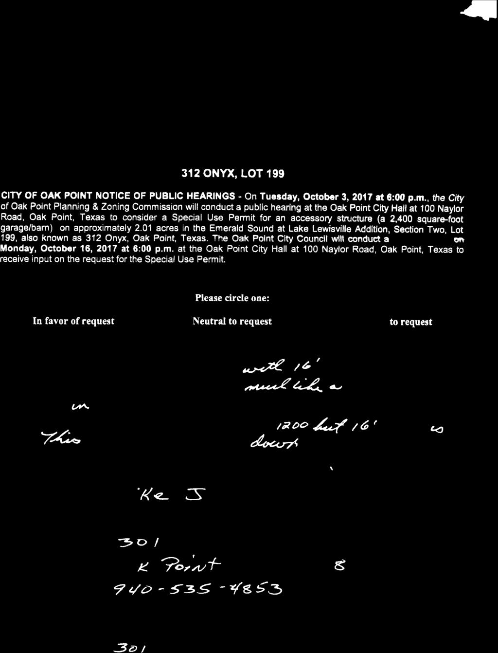
1 1. Call to Order, Roll Call, and Announce a Quorum is Present. (Collins) 2. Pledge of Allegiance. (Collins) 3. Consider and act upon minutes from the June 6, 2017 meeting of the Planning & Zoning Commission. (Bockes) 4. Conduct a public hearing, discuss and act upon a request for a Special Use Permit for an accessory structure (a 2,400 square-foot garage/storage building) on approximately 2.01 acres in the Emerald Sound at Lake Lewisville Addition, Section Two, Lot 199, also known as 312 Onyx Drive, Oak Point, Texas. (Coker) 5. Conduct a public hearing, discuss and act upon an amendment to the 2006 Comprehensive Plan for a tract of land consisting of approximately acres located on the west side of Yacht Club Road, 1,150 feet +/- south of Martingale Road, from Ranch Residential to Estate Residential. (Coker) 6. Conduct a public hearing, discuss and act upon a request to rezone approximately acres, located on the west side of Yacht Club Road, 1,150 feet +/- south of Martingale Road from RE-3 to Planned Development (PD) minimum one (1) acres lots. (Coker) 7. Consider and act upon topics to be scheduled for a future Planning & Zoning Commission meeting. The Planning & Zoning Commission is not permitted to take action on or engage in any discussion regarding an item not listed on the agenda. However, this agenda item provides an opportunity for any member of the Planning & Zoning Commission to propose that a topic be scheduled for a future meeting. Upon an item being proposed for discussion, the Planning & Zoning Commission will vote to determine its collective desire to schedule the item for discussion and/or action at a future meeting. A majority vote of the Planning & Zoning Commission is required to schedule an item for discussion and/or action at a future meeting. 8. Adjourn. The Planning & Zoning Commission of the City of Oak Point, Texas, reserves the right to meet in a closed session on any item listed on this Agenda should the need arise, pursuant to authorization by Texas Government Code, Sections (consultation with attorney), (deliberations about real property), (deliberations about gifts and donations), (personnel matters), (deliberations about security devices), (economic development), (homeland security). This facility is wheelchair accessible and accessible parking spaces are available. Requests for accommodations or interpretive services must be made 48 hours prior to the meeting. Please contact City Hall at or FAX for further information. NOTE: It is possible a quorum of Oak Point Council Members could be present, but the City Council will not take action on any issues. CERTIFICATION: Meeting Agenda Regular Meeting of the Oak Point Planning & Zoning Commission Oak Point City Hall 100 Naylor Road Oak Point, Texas Tuesday, October 3, :00 P.M. I do hereby certify that the above notice of this public meeting was posted on the designated bulletin boards at a.m. / p.m. on the 27th day of September, This notice was removed at a.m./p.m on the day of October, 2017 Amy Bockes, City Secretary Amy Bockes, City Secretary Regular Meeting of the Oak Point Planning & Zoning Commission Tuesday, October 3, 2017 Page 1 of 1
2 1. Call to Order, Roll Call, and Announce a Quorum is Present. (Collins) Chairperson Collins called the meeting to order at 6:01 p.m. with the following roll call: Neil Collins Chairperson Present Mark Boler Commissioner Present Helen Buttermark Commissioner Arrived at 6:04 p.m. Dena Meek Commissioner Present Jeff Stafford Commissioner Present Nancy Tremblay Commissioner Present Robert Burke Commissioner Absent City staff present: Meeting Minutes Regular Meeting of the Oak Point Planning & Zoning Commission Oak Point City Hall 100 Naylor Road Oak Point, Texas Tuesday, June 6, :00 P.M. Luke Olson Amy Bockes City Manager City Secretary And with a quorum present the following items were addressed: 2. Pledge of Allegiance. (Collins) Chairperson Collins led the Pledge of Allegiance. 3. Consider and act upon minutes from the May 2, 2017 meeting of the Planning & Zoning Commission. (Bockes) Commissioner Stafford motioned to approve the minutes from the May 2, 2017 Planning & Zoning Commission meeting as presented; motion seconded by Commissioner Tremblay. Motion passed with a vote of Consider and act upon a final plat of Wildridge Phase 3C consisting of 34 single-family residential lots and 1 HOA lot located on approximately acres in the E.A. Shahan Survey, Abstract No and William McNeil Survey, No. 814, Oak Point City limits and ETJ, Denton County, Texas. (Olson) Regular Meeting of the Oak Point Planning & Zoning Commission Tuesday, June 6, 2017 Page 1 of 2
3 City staff presented the final plat for Wildridge Phase 3C which contains 10 homes and 1 HOA lot within City limits and the other 23 homes located in the City s ETJ. The plat meets all the minimum requirements set forth in the development agreement. Staff recommended approval. Commissioner Stafford motioned that the Planning & Zoning Commission vote to recommend that the City Council approve a final plat for Wildridge Phase 3 C consisting of 34 single-family residential lots and 1 HOA lot located on approximately acres in the E.A. Shahan Survey, Abstract No and William McNeil Survey, No. 814, Oak Point City limits and ETJ, Denton County, Texas; motion seconded by Commissioner Buttermark. Motion passed with a vote of Consider and act upon a final of Wildridge Phase 3D consisting of 83 single-family residential lots and 1 HOA lot located on approximately acres in the William McNeil Survey, No. 814, City of Oak Point, Denton County, Texas. (Olson) City staff presented the final plat of Wildridge Phase 3D with all new residential lots being located within the City limits. The plat meets all of the minimum requirements set forth in the development agreement. Staff recommended approval. Commissioner Meek motioned that the Planning & Zoning Commission vote to recommend that the City Council approve a final plat of Wildridge Phase 3D consisting of 83 single-family residential lots and 1 HOA lot located on approximately acres in the William McNeil Survey, No. 814, City of Oak Point, Denton County, Texas; motion seconded by Commissioner Buttermark. Motion passed with a vote of Review and discuss the monthly Zoning & Development Activity report for May (Olson) City staff presented a brief overview of the monthly Zoning & Development Activity report and upcoming PD applications and process. 7. Consider and act upon topics to be scheduled for a future Planning & Zoning Commission meeting. (Collins) SUP for electric substation PD for 120+ acre tract 8. Adjourn. (Collins) Commissioner Stafford motioned to adjourn; motion seconded by Commissioner Tremblay. Motion passed with a vote of 6-0. The meeting adjourned at 6:25 p.m. Neil Collins, Chairperson ATTEST: Amy Bockes, City Secretary Regular Meeting of the Oak Point Planning & Zoning Commission Tuesday, June 6, 2017 Page 2 of 2
4 To: From: Re: Planning & Zoning Commission Michael Coker, City Planner SUP for an Accessory Structure located at 312 Onyx Date: October 3, 2017 Agenda Item: Conduct a public hearing, discuss and act upon a request for a Special Use Permit for an accessory structure (a 2,400 square-foot garage/storage building) on approximately 2.01 acres in the Emerald Sound Addition, Section Two, Lot 199, also known as 312 Onyx Drive, Oak Point, Texas. Accessory Building Requirements Section VIII(A)(3) of the Oak Point Zoning Ordinance states that a single accessory structure shall not exceed the following sizes unless otherwise approved by a Special Use Permit (SUP): Lot Size Less than one (1) acre One (1) acre and greater Maximum Size of Accessory Building Maximum of 600 s.f. under roof without a SUP Maximum of 1,200 s.f. under roof without a SUP Because the property is greater than one acre and the size of the proposed garage/storage building exceeds 1,200 square feet, the owners are requesting a Special Use Permit to allow the construction of the 2,400 square foot garage/storage building. The Zoning Ordinance also states that accessory structures are not allowed on a property without the primary use structure being in place. The applicant is aware of the requirements for a main structure and the accessory structure will not be constructed until the main structure is approximately 75% complete. Zoning The Emerald Sound Addition is zoned Planned Development-2 (PD-2) and allows for not more than one each detached garage, workshop, and barn may be constructed so long as they are of good construction, kept in good repair, and are not used for residential purposes. The properties in Emerald Sound are 1-acre or greater, each property owner is allowed two (2) accessory structures up to 1,200 square feet each. Accessory structures include, but not limited to: garages, hobby shops, barns, storage buildings, storm shelters, carport covers, well houses, gazebos, pergolas, cabanas and pools. Page 1 of 8
5 Special Use Permit Criteria In considering a Special Use Permit, the Planning & Zoning Commission and City Council are to evaluate the request using the following criteria. Following each of the criteria, City staff has indicated how the criteria may apply to the property and the request. 1. Is the requested structure and proposed construction compatible and harmonious with surrounding existing or proposed structures? Accessory buildings such as garages, garage/storage buildings, storage sheds, and workshops are common in residential areas in Oak Point. Section VIII(D)(4) of the Zoning Ordinance does require all accessory structures to be issued a building permit and must be constructed of a metal, masonry, or other weather durable material that is complimentary and compatible in design and construction to that of the main structure. As required by the Zoning Ordinance, the application for the Special Use Permit was accompanied by the attached site plan showing the proposed location of the accessory building in relation to the proposed main structure on the property and property lines. Prior to the permit being issued, approval from the Emerald Sound architectural committee will be required and include the construction materials, roofing and colors for the structure. 2. Has any impact on the surrounding area been mitigated? Upon approval of a Special Use Permit, some structures permitted may require mitigation such as screening, enhanced architectural design, or additional landscaping. However, most accessory buildings in residential areas are compatible and harmonious with other surrounding structures. 3. Will the proposed structures be appropriate in relation to the general area and the City as a whole? As noted above, accessory buildings such as garages, garage/storage buildings, storage sheds, and workshops are typical in residential areas in Oak Point. City staff believes that the proposed garage/storage building is appropriate in relation to the general area and the City as a whole. 4. Will the proposed structures meet the intent of the current Comprehensive Plan in place at the time of submission? The current zoning of the subject property is Planned Development-2 (PD-2), which is a 1- acre minimum tract developed as detached single family dwellings. The Future Land Use Plan designates the property as Estate Residential and the current zoning of the property is consistent with the Future Land Use Plan. As noted above, accessory buildings are typical in residential areas and the zoning allows for not more than one each detached garage, workshop, and barn may be constructed so long as they are of good construction, kept in good repair, and are not used for residential purposes. 5. Are there any other factors which will substantially affect the health, safety, morals, or general welfare of the citizens of the City of Oak Point? The proposed structure does not involve any factors which will substantially impact the health, safety, morals, or general welfare of the citizens of the City of Oak Point. Page 2 of 8
6 Budget Impact: The value of the accessory structure will result in additional tax dollars to the City. Legal Obligations and Review: A notice of the public hearing was published in the Little Elm Journal on Friday, September 8, Notices of the public hearing and reply forms were mailed to property owners within 200 feet of the subject property on September 8, A zoning sign was also placed on the property. As of Tuesday, September 26, 2017, City Staff received one (1) reply in favor of the request, and six (6) reply opposing the request. Reply forms are attached. Unlike the ministerial process associated with plats and site plans, zoning decisions are discretionary. While the request does appear to meet the criteria that are necessary for approval of a Special Use Permit, the Planning & Zoning Commission and City Council are not obligated to approve the request should they feel that the request does not adhere to the criteria. Attached Documents: Location Map/Zoning Map Aerial Map Site Plan Building Elevations Proposed Uses Reply Forms Board, Committee and/or Staff Recommendation: City staff recommends that the Planning & Zoning Commission recommend that the City Council approve a request for a Special Use Permit for an accessory structure (a 2,400 squarefoot garage/storage building) on approximately 2.01 acres in the Emerald Sound Addition, Section Two, Lot 199, also known as 312 Onyx Drive, Oak Point, Texas subject to: 1) The accessory structure comply with the construction and design requirements of the Zoning Ordinance; and 2) Approval from the property owner s association prior to the permit being issued. Page 3 of 8
7 Alternatives: If the Planning & Zoning Commission chooses not to approve the request for the Special Use Permit as recommended, the Planning & Zoning Commission can vote to: 1. Table the request to a specific meeting date. (Tabling is recommended only if the P&Z Commission provides specific direction to City staff and/or the applicant AND the applicant expresses some willingness to modify the zoning request.) 2. Recommend approval of the request with conditions. 3. Recommend denial of the request. Page 4 of 8

8 Location/Zoning Map Subject Property Page 5 of 8

9 Approximate Location of Main Structure Aerial Map Approx. Location of Accessory Structure Page 6 of 8
10 Site Plan PROPOSED LOCATION OF GARAGE 312 ONYX Page 7 of 8

11 Building Elevation Width: 40 Length: 60 Eave Height: 16 Roof Pitch: 3:12 Page 8 of 8

12


13
14

15

16

17
18
19
20 To: From: Planning & Zoning Commission Michael Coker, City Planner Re: Planning & Zoning Commission Meeting October 3, 2017 Date: September 27, 2017 Agenda Item: Conduct a public hearing, discuss, and act upon a request to amend the City of Oak Point s Comprehensive Plan, specifically the future land use element of the plan. The request is to amend a acre tract of land west of Yacht Club Road and South of Martingale Road from Ranch Residential to Estate Residential Description of Agenda Item: History Tom Lilly currently owns approximately acres located west of Yacht Club Road, approximately 1,150 +/- south of Martingale. All acres is located within the City of Oak Point limits and is currently zoned Ranch Residential 3 (RE-3) for a minimum 3 acre lots. The applicant has requested to amend the City s comprehensive plan from Ranch Residential to Estate Residential. The Comprehensive Plan is intended to serve as a guide for policy decisions relating to the physical, social, and economic growth of the community. The Plan establishes the vision and direction of the community. A comprehensive plan is to a community what a business plan is to a business. While Oak Point s Comprehensive Plan should be flexible enough to respond to changing needs, the community should remain steadfast in its vision and support for the core goals and objectives contained in the Plan. The City of Oak Point s Comprehensive Plan is organized into eight individual plan elements or chapters. Each chapter of the Plan is developed to specifically address the current and anticipated needs of the community by including a summary of existing conditions, discussion of issues, followed by goals, objectives, and actions. The chapters that are generally applicable to zoning requests include Land Use, Transportation, Economic Development, Community Facilities and Services, and Water, Wastewater and Drainage. Agenda Item No. 5 Page 1 of 7
21 The Future Land Use Plan (FLUP) reflects the desired pattern of growth in the City and ETJ. The FLUP provides City staff and City officials with a guide for day-to-day land use decisions to ensure that development occurs in an orderly and efficient manner. While the FLUP is intended to guide public and private decision making for future land use and development within the community, it is important to realize that the FLUP is a conceptual plan. The Land Use Chapter of the Comprehensive Plan states that it is generally agreed that the predominant land use for Oak Point should be large lot (one acre or larger), single-family homes in a rural setting. However, five classifications of residential land use are depicted on the FLUP to provide for a range of housing sizes, types, and densities to meet the future needs of Oak Point. Each residential classification is defined by density. The term density is used to illustrate the maximum number of housing units per acre allowed. Density is defined as the maximum number of dwelling units per acre determined by dividing the total number of proposed units in a tract of land by the total number of acres, excluding common open space, rights-of-way, parks, drainage ways, flood ways and community facilities. The residential designations depicted on the FLUP include: Residential Designation Ranch Residential Estate Residential Country Residential High Density Residential Manufactured Home Density Maximum of 0.3 units per acre Maximum of 1.0 unit per acre Lot size greater than 1.0 unit per acre Maximum of 3.8 units per acre Maximum of 2.0 units per acre Current Comprehensive Plan: (Future Land Use) The current Comprehensive Plan designates the future land use for the subject property as Ranch Residential. Ranch Residential prescribes as residential density of 0.3 residential units per acre or roughly on residential unit for each three acres of land. The requested change to the land plan is Estate Residential. The Future Land Use Plan states that the purpose of this land use category is to provide medium acre single-family detached residences with generous amounts of open space per lot. This land use category provides for residential development of single-family detached dwellings at a density not greater than 1.0 unit per acre. The City Council has a long-standing policy that higher density development should be located on the east side of FM 720 and that lower density residential developments should be maintained on the west side of FM 720. In this regard, the requested amendment to the plan conforms to the City Council policy. Implementation: The Future Land Use Plan is a very general plan for future land use development. It bridges the gap between existing and future development. In using land use principles and policies it is Agenda Item No. 5 Page 2 of 7
22 available to guide new projects so that they may better blend into the community. The Plan is not to be considered etched in stone of viewed as zoning. The areas shown on the map are considered to be the best use of the property at the time the map was developed. The map does not attempt to predetermine the use of each individual tract, but seeks to establish a logical framework for future land use and development decisions. The Future Land Use map was originally created in Amendments to the Future Land Use Plan: It is recognized that circumstances will change in the future and the Comprehensive Plan will require modifications and refinements to be kept up-to-date and current. Needed adjustments and changes to the Future Land Use Plan and other components of the Land Use element should be carefully considered as part of the annual Plan updates and five-ear major Plan revisions. Amendments to the Future Land Use Plan should be subject to the same scrutiny and considered through the same public processes and procedures reqruie in any ordinance change. Legal Obligations and Review: In preparation for the public hearings scheduled for the Planning & Zoning Commission meeting on Tuesday, October 3, 2017 and the City Council meeting on Monday, October 16, 2017, a notice of the public hearing was published in the Little Elm Journal on Friday, September 8, 2017 and on the City s website. There were no mailing requirements associated with this amendment. Attached Documents: Exhibit 1 - Zoning Map Exhibit 2 Future Land Use Plan Exhibit 3 Thoroughfare Plan Board, Committee and/or Staff Recommendation: The request to amend the Comprehensive Plan regarding the Future Land Use Plan for approximately acre tract of land located west of Yacht Club Road and South of Martingale Road from Ranch Residential to Estate Residential appears to be consistent with City Council policy and Comprehensive Plan guideline. Alternatives: If the Planning & Zoning Commission does not concur with City staff s recommendation, other options are available to the Planning & Zoning Commission. The Planning & Zoning Commission can vote to: 1. Recommend that the City Council approve the request with conditional changes. Agenda Item No. 5 Page 3 of 7
23 2. Table the request to a date specific meeting. (Tabling is recommended only if the Planning & Zoning Commission clearly states the reason for tabling and provides specific direction to City staff and/or the applicant.) 3. Recommend that the City Council deny the request. Agenda Item No. 5 Page 4 of 7

24 EXHIBIT-ZONING MAP Subject Property Agenda Item No. 5 Page 5 of 7

25 Exhibit Future Land Use Plan Agenda Item No. 5 Page 6 of 7
26 Thoroughfare Plan Agenda Item No. 5 Page 7 of 7
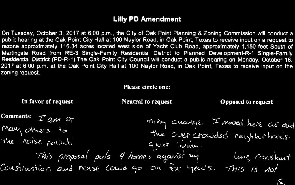
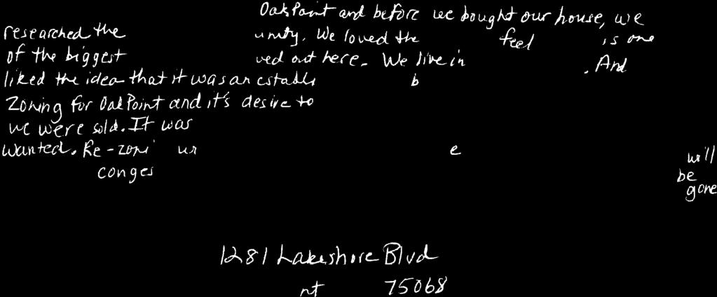
27 To: From: Planning & Zoning Commission Michael Coker, City Planner Re: Planning & Zoning Commission Meeting October 3, 2017 Date: September 27, 2017 Agenda Item: Conduct a public hearing, discuss, and act upon a request to rezone approximately acres located on the west side of Yacht Club Road, approximately 1,150 feet south of Martingale from RE-3 Single-Family Residential District to Planned Development-PD-17-R1 Single-Family Residential District (PD-17-R1). Description of Agenda Item: History Tom Lilly currently owns approximately acres located west of Yacht Club Road, approximately 1,150 +/- south of Martingale Road. All acres is located within the City of Oak Point limits and is currently zoned Ranch Residential 3 (RE-3) for a minimum one unit per 3 acre lots. The applicant has requested a rezoning of the property to create a Planned Development with minimum one (1) acre lots. Current Zoning The current zoning of the subject property is RE-3 Ranch Residential". The RE-3 District is a residential district intended for the development of detached single-family dwelling units on minimum three (3) acre tracts or lots. Zoning, Use, and Designations of Surrounding Properties The zoning, existing use, and Future Land Use Plan (FLUP) designation of properties surrounding the acres are as follows: Zoning Existing Land Use FLUP Designation North R-4X Crescent Oaks Beach Estates (Minimum 10,000 square foot lots) Rural Residential East PD-3 PD-9 RE-5 Hunters Ridge (5 acre minimum) Prestonwood Polo (2.5 gross/1 net acre) Undeveloped (Default Zoning) Planned Development Planned Development Ranch Residential South PD-1 Eagles Landing (min. 1 acre lots) Planned Development Agenda Item No. 6 Page 1 of 27
28 West R-3X (Minimum 1 acre lots) Crescent Oaks Beach Estates (Minimum 15,000 square foot lots) Rural Residential Requested Zoning The applicant is requesting to rezone the property to Planned Development-17-R1 Single-Family Residential District (PD-17-R1) with one acre minimum lot sizes. Planned development zoning provides an opportunity for flexibility in defining zoning regulations for the development of a specific property as determined by an amending ordinance for each development, while ensuring the intent of this ordinance (the Zoning Ordinance), existing land-use plans and the Comprehensive Plan are met. Planned Development (PD) zoning should generally be used as a tool to modify zoning standards to accommodate unique projects rather than simply using PD zoning as a mechanism to reduce development standards. PD-17-R1 would allow for the development of a maximum of 89 single-family residential units on the acre property. Any development standards that are not addressed by the PD will default to the R1 Single-Family Residential District. Permitted Uses The requested zoning is intended primarily for the development of detached single-family dwelling units. However, other uses that are accessory to residential uses such as parks, other recreational uses, home occupations, and accessory structures are also permitted. Lot Size and Density The development standards (see Exhibit 8) for PD-17 are structured to allow lots with minimum areas of 43,560 square feet. The following chart compares the development standards for PD- 17 to the standards of the R1 District and surrounding R4X Zoning. PD-17 PD-1 R4X Minimum Lot Area 43,560 square feet 43,560 square feet 10,000 square feet Minimum Dwelling Area 2,500 square feet 2,500 square feet 1,250 square feet Minimum Lot Width 130 feet 130 feet 60 feet Minimum Lot Depth 150 feet None specified 100 feet Maximum Height 40 feet 50 feet 35 feet Minimum Front Yard 45 feet 50 feet 25 feet Minimum Side Yard 20 feet 20 feet 10 feet Minimum Rear Yard 40 feet 20 feet 30 feet Maximum Lot Coverage 30% None specified 30% Minimum Dwelling Area As shown above, the minimum dwelling areas required for homes within PD-17 are 2,500 square feet. In comparison, the minimum dwelling areas required of homes in other areas of Oak Point are: Agenda Item No. 6 Page 2 of 27
29 Subdivision Zoning Minimum Dwelling Area Crescent Oaks R4X and R3X 1,250 s.f. and 1,500 s.f. Eagles Landing PD-1 1,800 s.f. (2,500 s.f. after Feb 2000) Emerald Sound PD-2 2,000 s.f (2,500 s.f. for Lots ) Gates of Waters Edge PD-8 2,500 s.f. Hunters Ridge Addition PD-3 2,000 s.f. Hunters Ridge Estates PD-5 2,500 s.f. Rudman property PD-7 1,100 s.f. Shore Acres/Cedar Pine Lane R4X and R3X 1,250 s.f. and 1,500 s.f. Woodridge Estates PD-6 1,400 s.f. 1,500 s.f., and 1,800 s.f. Yacht Club Estates R3X 1,500 s.f Open Space and Landscaping The development standards for PD-17 do not designate open space located within the proposed development. The development standards for PD-17 also require that at least two trees of three (3) caliper inches or greater be provided on each single-family lot. Existing healthy trees of any variety, with a minimum of three (3) caliper inches, may count towards meeting these requirements. Comprehensive Plan The Comprehensive Plan is intended to serve as a guide for policy decisions relating to the physical, social, and economic growth of the community. The Plan establishes the vision and direction of the community. A comprehensive plan is to a community what a business plan is to a business. While Oak Point s Comprehensive Plan should be flexible enough to respond to changing needs, the community should remain steadfast in its vision and support for the core goals and objectives contained in the Plan. The City of Oak Point s Comprehensive Plan is organized into eight individual plan elements or chapters. Each chapter of the Plan is developed to specifically address the current and anticipated needs of the community by including a summary of existing conditions, discussion of issues, followed by goals, objectives, and actions. The chapters that are generally applicable to zoning requests include Land Use, Transportation, Economic Development, Community Facilities and Services, and Water, Wastewater and Drainage. Land Use The Future Land Use Plan (FLUP) reflects the desired pattern of growth in the City and ETJ. The FLUP provides City staff and City officials with a guide for day-to-day land use decisions to ensure that development occurs in an orderly and efficient manner. While the FLUP is intended to guide public and private decision making for future land use and development within the community, it is important to realize that the FLUP is a conceptual plan. The Land Use Chapter of the Comprehensive Plan states that it is generally agreed that the predominant land use for Oak Point should be large lot (one acre or larger), single-family homes in a rural setting. However, five classifications of residential land use are depicted on the FLUP Agenda Item No. 6 Page 3 of 27
30 to provide for a range of housing sizes, types, and densities to meet the future needs of Oak Point. Each residential classification is defined by density. The term density is used to illustrate the maximum number of housing units per acre allowed. Density is defined as the maximum number of dwelling units per acre determined by dividing the total number of proposed units in a tract of land by the total number of acres, excluding common open space, rights-of-way, parks, drainage ways, flood ways and community facilities. The residential designations depicted on the FLUP include: Residential Designation Ranch Residential Estate Residential Country Residential High Density Residential Manufactured Home Density Maximum of 0.3 units per acre Maximum of 1.0 unit per acre Lot size greater than 1.0 unit per acre Maximum of 3.8 units per acre Maximum of 2.0 units per acre The FLUP designates Ranch Residential uses for the acre property. The purpose of the Ranch Residential land use category is to accommodate single-family detached residences on medium acre lots with generous amounts of open space per lot. This land use category provides for residential development of single-family detached dwellings at a density not greater than 0.3 unit per acre. Land Use Policies The Land Use Chapter of the Comprehensive Plan contains a number of policies that serve as guides for decision-making. The Plan states that the policies should be a continual reference for City officials and City staff to assure that goals, objectives and actions are addressed when reviewing zoning classification changes or amendments to the Future Land Use Plan. The policies are: 1. Residential development densities should reflect the desires of the community to maintain its rural character. Lot sizes of at least one house per acre net are recommended. With a proposed density of less than one house per acre net, the requested zoning is not consistent with the one house per acre net recommendation. 2. Residential lots should be discouraged from backing to arterial or major streets. The design of the concept plan does not depict any lots backing directly to arterial or major streets. 3. Residential areas should be buffered from incompatible uses and where adjacent to thoroughfares through the use of landscaping features, distance separation and/or screening walls. Agenda Item No. 6 Page 4 of 27
31 The concept plan shows four lots adjacent to Yacht Club Road the PD requires landscape buffers along Yacht Club Road between the four lots and the roadway. No driveway access will be allowed onto Yacht Club Road. 4. Natural features should be preserved. Greenbelts and trails should take advantage of the natural environment to link different residential areas to each other, and to City and community facilities. The property does contain several trees and ponds. The PD requires preservation of numerous trees and all ponds located on the property. No greenbelts or trails are required. 5. New local residential streets should be encouraged to be rural in character. Lots will not face Yacht Club Road and driveway connections to Yacht Club Road will not be permitted. There will be no improvements done to Yacht Club Road and landscape buffers are noted in previous paragraphs. 6. Local streets should also be curvilinear and provide green space either in the median or parkway to ensure a rural neighborhood atmosphere. Street patterns generally depicted in the concept plan shall be considered curvilinear for the purpose of satisfying requirements in the City Ordinances. 7. Collector streets should be tree-lined and maintain the rural character of the community. The subject property runs parallel to Yacht Club Road and will have landscape buffers including existing trees along the property line. 8. Community facilities should be centrally located together in easily accessible areas within the community, adjacent to major streets to accommodate traffic and should be accessible by trails and sidewalks. No municipal facilities are proposed to be located on the subject property. There are no proposed amenity centers in the development and side-walks are not required. 9. Adequate park dedication for all new residential subdivisions should be evenly dispersed throughout the city and there should be linkages between parks, schools and residential areas. Natural features, such as creeks and floodplains, should be preserved in parks and open space areas. The City s Parks and Trails Plan does not show any parks or trails on the subject property. Because the Parks and Trails Plan does not show a park on the subject property, the planned development standards state that City park fees will be paid in lieu of park dedication. Park fees are used by the City to purchase or make improvements to City parks. Agenda Item No. 6 Page 5 of 27
32 10. Commercial uses within the City should be concentrated within the 720 Corridor Overlay District, should be large enough to accommodate intended uses with adequate parking and suitable landscaping, and should be developed in accordance with the provisions of the 720 Corridor Overlay District. Commercial uses should include a variety of neighborhood stores and freestanding commercial sites. Where possible, commercial uses should be located adjacent to City facilities and arranged in a town square concept. This policy is not applicable to this zoning request. 11. Transportation access and circulation should be provided from existing and future residential neighborhoods to future commercial areas, but should not infringe upon neighborhoods. All access to future commercial areas along F.M. 720 will be provided via McCormick Road and Martingale Road. 12. Development along FM 720 should be consistent in design and reflect the development standards for all future development adjacent to FM 720 through the use of architectural standards for buildings, landscape buffers, lighting and signage as established in the 720 Corridor Overlay District. This policy is not applicable to this zoning request. In addition to the above listed policies, the Land Use Chapter of the Plan contains a number of goals, objectives, and actions which serve as a foundation for guiding future land use within the City. These goals, objectives, and actions include: Land Use Goal: Maintain Oak Point s unique country atmosphere with an appropriate variety of land uses for both residential and commercial development. Objective 3.1: Assure that new developments are compatible with existing City neighborhoods. Action 3.1.1: Require new developments adhere to development standards and design guidelines. If the requested zoning is approved, any development on the property will be required to adhere to the development standards contained within PD-17 and any applicable requirements of the City s Zoning and Subdivision Ordinances. Action 3.1.2: Locate appropriate commercial uses along FM 720 in the 720 Corridor Overlay District ensuring that architectural standards, landscape buffering, lighting and signage adhere to development standards established for the 720 Corridor Overlay District. This action policy is not applicable to this zoning request. Action 3.1.3: Review all new development to ensure conformity with the Future Land Use Plan. Agenda Item No. 6 Page 6 of 27
33 As noted above, the FLUP designates Ranch Residential uses for the property. Because the proposed density exceeds the density recommendations of the Ranch Residential designation, the request does not conform to the FLUP. Objective 3.2: Protect the natural landscapes. Action 3.2.1: Require all new residential development preserve existing trees and natural features. While the property does contain several trees and ponds, the subject property contains no other significant natural features. PD-17 requires the preservation of trees for landscape requirements and ponds will remain in their natural state. Action 3.2.2: Place natural areas in parks and greenbelt areas. The subject property contains significant natural areas and ponds. The concept plan for the project was designed so that the areas of the project that have ponds and larger trees are preserved to protect natural areas. Action 3.2.3: Require additional setbacks in zoning to allow rural streetscapes along major collectors and arterial streets. The setback adjacent to Yacht Club Road is proposed to be 20 and any preserved trees along Yacht Club Road would satisfy all roadway screening and buffering requirements. Action 3.2.4: Require all new developments to incorporate adequate open space. The request does not propose open space and therefore does not conform to this policy. Action 3.2.5: Link new and existing neighborhoods with a system of trails. Transportation The City s Parks and Trails Plan does not show any parks or trails on the subject property. The City s Thoroughfare Plan shows the general alignment and size of collector sized streets and greater. No streets depicted on the Thoroughfare Plan are planned to extend through or adjacent to the subject property. Each lot within a proposed subdivision should have two means of access to and from the property for emergency response and traffic distribution purposes. Access to the subject property will be derived through two entrances off of Yacht Club Road. There are no additional collector roads required or planned. Agenda Item No. 6 Page 7 of 27
34 Economic Development The guiding principles, goals, and objectives contained in the Economic Development chapter of the Comprehensive Plan are not applicable to this zoning request, because the guiding principles, goals, and objectives are directed towards retail and commercial development as opposed to residential development. While the development of the property may not tie directly to the principles, goals, and objectives contained in the Economic Development chapter of the Comprehensive Plan, it should be noted that the development of the subject property could result in the construction of approximately 89 additional homes in Oak Point s retail trade area. Besides increasing the number of rooftops in Oak Point s retail trade area which will likely result in the development of some sales tax generating retail businesses at the intersection of FM 720 and Shahan Prairie Road/McCormick Road, sales tax will be generated by utilities and home businesses associated with these homes. It should also be noted that retail development is typically driven more by surrounding rooftops (population density) than by drive-by traffic. In order for Oak Point to attract retail businesses, the number of homes in the Oak Point area must increase. A greater number of rooftops equates to a greater demand for retail which equates to a greater amount of sales tax collected by the City. Community Facilities and Services Parks The City s Parks and Trails Plan does not show a park or trails on the subject property. Because the subject property is not designated for a park, City park fees will be paid in lieu of park dedication when homes are constructed. Schools The subject property is located within the Little Elm Independent School District (LEISD). City staff recently forwarded information regarding development activity in Oak Point to a demographer employed by the DISD and the Little Elm Independent School District. Municipal Facilities The City does not currently have a need for any type of municipal facility in the immediate vicinity of the property. Water, Wastewater and Drainage Water The property is located within Mustang Special Utility District s service area. Representatives of the development have communicated their plans to Mustang SUD. Wastewater This property will require individual septic systems (OSSF). Agenda Item No. 6 Page 8 of 27
35 Other Factors to Consider When Evaluating a Zoning Request When reviewing zoning requests or amendments to the FLUP, the FLUP and the policies contained within the Comprehensive Plan should be referenced by City officials and City staff to assure that the goals, objectives and actions of the Plan are addressed. In addition, the City s Zoning Ordinance states that the Planning and Zoning Commission shall also consider several factors when making a recommendation on a zoning change to the City Council. These factors include: 1. Whether the uses permitted by the proposed change will be appropriate in the immediate area of concern and their relationship to the general area and the City as a whole. In addition to consulting the FLUP when evaluating zoning requests, the current land use and current zoning of adjacent properties should be considered to determine the appropriateness of the proposed change. Although the property is designated for Ranch Residential use by the FLUP, the property is bordered to the north by R-4X Rural Residential, south by Planned Development-1 (Estate Residential), east by Planned Development-3 Ranch Residential and Planned Development-9 (minimum 2.5 acres lots), and the west by, R-3X Rural Residential). Lot sizes are noted above in a table of surrounding zoning. 2. Whether the proposed change is in accordance with any existing or proposed plans for providing public schools, streets, water supply, sanitary sewers, and other utilities to the area, and shall note the findings. As noted above, there are no existing or proposed plans for municipal facilities or schools on the property. 3. The amount of vacant land currently classified for similar development in the vicinity and elsewhere in the City, and any special circumstances which may make a substantial part of such vacant land unavailable for development. The only areas currently zoned for similar development as the request are Eagles Landing and Emerald Sound with minimum one acre lots. Other surrounding vacant areas are zoned the same as the current zoning of the property for the rezoning request. 4. The recent rate at which land is being developed in the same zoning classification as the request, particularly in the vicinity of the proposed change. There has been rapid development throughout the City, with most of the development being located on the West side of FM 720 zoned for high density. Areas with similar zoning as the proposed change have seen steady building permits for vacant lots left within the areas, but still have open lots not yet developed. Budget Impact: Approval of the requested zoning could lead to the development of up to 89 additional homes in the City of Oak Point requiring the City to provide services to the future homeowners. Agenda Item No. 6 Page 9 of 27
36 Mustang Special Utility District is the water provider for the property. As it does today, the City will be required to provide police and fire protection services to the property Legal Obligations and Review: In preparation for the public hearings scheduled for the Planning & Zoning Commission meeting on Tuesday, October 3, 2017 and the City Council meeting on Monday, October 16, 2017, a notice of the public hearing was published in the Little Elm Journal on Friday, September 8, 2017 and notices of the public hearing were mailed to property owners within 200 feet of the subject property on Friday, September 8, Zoning signs were also placed on the property. Each of the notices that were mailed to the property owners included reply forms that owners may use to submit their position on the requested zoning. As of Wednesday, September 27, 2017, Fourteen (14) reply forms had been submitted to City Hall all in opposition of the request. Unlike the ministerial process associated with plats and site plans, zoning decisions are discretionary. The Planning & Zoning Commission and City Council are under no obligation to approve or deny the zoning request. Attached Documents: Exhibit 1 Location Map Exhibit 2 Aerial Map Exhibit 3 - Zoning Map Exhibit 4 Future Land Use Plan Exhibit 5 Thoroughfare Plan Exhibit 6 National Wetlands Map Exhibit 7 Zoning Exhibits/Concept Plans Exhibit 8 PD Standards and Exhibits Reply Form(s) s (responses outside the 200 foot area) Board, Committee and/or Staff Comments/Concerns: If the Planning & Zoning Commission failed to approve the requested amendment to Future Land Use Plan to allow for one acre lots on the subject property, then the recommendation is for denial since the request would be inconsistent with the current Comprehensive Plan. Below are the comments/concerns presented by the City planner in regards to the request: The concept plan shows utility easements bifurcating lots limiting the developable area of the lots. These utility easements significantly reduce the buildable area of some of the lots once the required setbacks are provided. The concept plan shows many of the lots having a large portion of the lot located in ponds or water impoundments. These lots having substantial portions of the lots Agenda Item No. 6 Page 10 of 27
37 located within the water surface areas of existing pons and water impoundments reduces the developable area of those lots. Each lot should have a minimum lot size of 43,560 square feet exclusive of the 50-foot electric easement and the 20-foot Mustang Special Utility District water line easement and all existing impounded water surfaces and drainage areas. Corner lots should have the same required front yard setback on both the street frontages in order to maintain setback consistency along all the road frontages. Any gated streets within the proposed planned development should require approval by the Planning & Zoning Commission and City Council. Garage doors should not face an adjacent street. The proposed Planned Development should not provide for elements that are inconsistent with the City s Subdivision Regulations. At the time of platting, sufficient right-of-way for half of the required 60 foot right-ofway shall be required from the subject property. The required right-of-way shall be measured from the center line of the existing right-of-way and shall provide at least 30 feet of right-of-way from the west side of Yacht Club Road. Necessary improvements to Yacht Club Road adjacent to the subject property shall be required as part of the platting and public improvement coincident with the development of the subject property. Any revisions or modification to the conceptual plan prior to approval of the preliminary or final plat for any phase of the development shall require review and approval by the Planning & Zoning Commission and City Council. Any preliminary plat or final plat for any phase of the development shall comply with the approved conceptual plan. The request does not include and public or open space within the boundaries of the proposed planned development, except for a landscape buffer area adjacent to Yacht Club Road. A home owners association should be required to maintain the common areas, ponds and drainage areas within the boundaries of the Planned Development District. Proposed HOA requirements and restriction should be provided for Planning & Zoning Commission and City Council review prior to adoption of any ordinance approving this change in zoning. Agenda Item No. 6 Page 11 of 27
38 Board and Commission Options: The Planning & Zoning Commission can vote to: 1. Recommend that the City Council approve the request with conditional changes. 2. Table the request to a date specific meeting. (Tabling is recommended only if the Planning & Zoning Commission clearly states the reason for tabling and provides specific direction to City staff and/or the applicant.) 3. Recommend that the City Council deny the request. Agenda Item No. 6 Page 12 of 27

39 Exhibit 1 Location Map Agenda Item No. 6 Page 13 of 27

40 Exhibit 2 Aerial Map Agenda Item No. 6 Page 14 of 27

41 Exhibit 3 Zoning Map Subject Property Agenda Item No. 6 Page 15 of 27

42 Exhibit 4 Future Land Use Plan Subject Property Agenda Item No. 6 Page 16 of 27

43 Exhibit 5 Thoroughfare Plan Agenda Item No. 6 Page 17 of 27

44 Exhibit 6 National Wetlands Map Agenda Item No. 6 Page 18 of 27

45 Exhibit 7 Zoning Exhibit/Concept Plans Agenda Item No. 6 Page 19 of 27
46 Exhibit 8 Submitted Planned Development Standards All zoning regulations, standards, uses, requirements, and processes for the R4X District of the City of Oak Point Zoning Ordinance (Ord. No ), as it exists or may be amended, shall apply to the Planned Development except as follows: 1. The maximum number of single-family residential units permitted shall be The following single-family residential lot development standards shall apply: a. The minimum lot area shall be 43,560 sq. ft. b. The minimum lot area net of normal water surface shall be 21,780 sq. ft., said area being described by metes and bounds on the final plat. c. The minimum dwelling area (air-conditioned) shall be 2,500 sq. ft. d. The minimum lot width shall be 130 ft. measured along the platted front yard building line. e. The minimum lot depth shall be 150 ft., measured at the midpoints of the front and rear lot lines, or as otherwise approved by the city staff in unusual geometric situations. f. The maximum lot coverage shall be 30%, including main structures and accessory structures. g. The maximum structure height shall be two and one-half (2 ½) stories measured at the highest point of the structure, not to exceed forty feet (40 ). h. The minimum front yard shall be 45 ft. i. The minimum side yard shall be 20 ft. j. The minimum side yard adjacent to a street shall be 20 ft., unless the lot is a corner lot that backs to the side of an adjacent lot, then the minimum side yard adjacent to the street shall be 30 ft. k. The minimum rear yard shall be 40 ft. 3. Construction and Architectural Standards a. The main structure for residential uses shall be constructed of a minimum of 80% total masonry for all facades, exclusive of doors, windows, porches, chimneys, and walls provided in conjunction with an architectural element above the roof line (example: walls for dormers). No single façade shall have less than 75% masonry. Façade shall mean: Any separate face of a structure, including parapet walls and omitted wall line, or any part of a structure which encloses or covers usable space. Where separate faces are oriented in the same direction, or in directions within 45 degrees of one another, they are to be considered part of a single façade. Masonry shall consist of brick, stone, or similar masonry unit type materials, or a minimum of one (1 ) inch thick stucco construction. Agenda Item No. 6 Page 20 of 27
47 b. Roof slopes for the main structure of residential uses shall be a minimum of 8:12 and roof construction shall include opposing roof elements on the front facade and at least one other facade, unless otherwise approved by the Planning & Zoning Commission and/or City Council. c. All ground level mechanical, heating, ventilation, and air conditioning equipment shall be screened from view from a street with fence or landscaping that is at least six feet tall. d. All single family residential units shall be required to provide at least three of the following architectural elements: i. 100 percent of each wall is finished with a masonry material exclusive of doors, windows, porches, chimneys, and walls provided in conjunction with an architectural element above the roof line (example: walls for dormers); ii. The front façade contains two types of complementary masonry finishing materials, with each of the materials being used on at least 25 percent of the front façade; iii. A minimum of 10 percent of the unit s front façade features patterned brick work, excluding soldier or sailor brickwork provided in association with a door or window; iv. The unit only features garage doors that have a carriage style design; v. A minimum of three offsets in the front façade measuring at least one feet deep are provided or a minimum of one offset in the front façade measuring at least three feet is provided; vi. The unit features an articulated front entrance through the use of lintels, pediments, keystones, pilasters, arches, columns, or other similar architectural elements; vii. A covered front porch which is at least 100 square feet in area is provided; viii. At least one dormer is provided for each roof plane over 500 square feet in area that faces a street. The dormer must be appropriately scaled for the roof plane and shall not be wider than the windows on the building elevation below; or ix. Roof pitch at 10:12 side to side is incorporated into the front of the house; x. At least 50% of the windows facing a street feature shutters which must be in scale with the corresponding window; or xi. Other innovative designs as may be requested by an applicant and approved by staff, or in staff s discretion or denial forwarded to the Planning and Zoning Commission for consideration, and if denied by the Planning and Zoning Commission, then appealed to the City Council. Such designs shall not have an adverse impact on current or future development, shall be in keeping with the spirit of the purpose of this section, shall not reduce the quality of the development, and shall not have an adverse impact on the public health, safety, and general welfare. Such applications and approvals shall not constitute an amendment of the Planned Development. 4. General Conditions and Restrictions a. Lots shall not front on to Yacht Club Road. b. Driveway connections to Yacht Club Road are not permitted. Agenda Item No. 6 Page 21 of 27
48 c. Gated private streets shall be allowed, but not required. d. Applicable City park fees will be required in lieu of park land dedication requirements. e. The street pattern generally depicted on the concept plan (Exhibit A and D) shall be considered curvilinear for the purposes of satisfying any such requirements in the City of Oak Point ordinances. f. Maximum block length shall be 1,200. Block length shall be defined as the distance along a street centerline between one or more intersecting streets (between a T intersection, or a 4-way intersection). A deflection in the centerline alignment of the street that is greater than 20 degrees, i.e., and elbow or eyebrow, or a roundabout, shall also terminate a block length for the purposes of this paragraph. g. A cul-de-sac roadway crossing the existing tributary between the two points in the northwest portion of the planned development may be longer than 600, but not greater than 1,400 (measured along the centerline of the street), provided an area of pavement at least as large as a standard cul-de-sac (area and dimensions) is located along the street at intervals not greater than 850 (measured along the centerline of the street) for vehicular turn-around movements. h. Sidewalks are not required. i. The land plan and site data depicted on Exhibit D is conceptual and subject to change. Revisions to the plan shall not constitute an amendment of the PD, or require the submittal and approval of a revised plan prior to submittal of a preliminary plat, provided all restrictions of the PD are adhered to, and provided the revised plan is in accordance with the subdivision rules and regulations unless superseded by the PD or waived by the City staff, Planning & Zoning Commission, and/or City Council. j. Phasing of the development may occur, provided the subdivision rules and regulations are adhered to unless superseded by the PD or waived by the City Staff, Planning & Zoning Commission, and/or City Council, as applicable. k. The minimum width of landscaped open space adjacent to Yacht Club Road shall be 20 ft. At a minimum, landscaping shall include irrigation and 3-inch caliper trees selected from the Large/Shade Tree List, as defined by the City of Oak Point Zoning Ordinance Appendix C Approved Landscape Materials, and crepe myrtles. At a minimum, one Large/Shade Tree and a combination of two ornamental trees or 500 square feet of ornamental planting at a 3-gallon average shall be required for every thirty (30) linear feet of landscaped open space adjacent to Yacht Club Road. An existing, healthy tree greater than 3-inch caliper that is preserved, regardless of species or type, shall satisfy the planting requirements for one required tree. The requirements of this section shall satisfy all roadway screening and buffering requirements for Yacht Club Road. Agenda Item No. 6 Page 22 of 27
49 l. Right-of-way dedication for Yacht Club Road required at the time of platting shall include sufficient width to achieve 60 of total right-of-way measured from the east line of the then existing right-of-way, but not to exceed 30 of dedication unless the land along the east side is currently platted. m. Improvements to Yacht Club Road are not required. o. At least two (2) trees with a minimum of three (3) caliper inches selected from the Large/Shade Tree List, as defined by the City of Oak Point Zoning Ordinance Appendix C Approved Landscape Materials, shall be provided within the front yard of each singlefamily residential lot. Each existing healthy tree of any variety, with a minimum of three (3) caliper inches, that is preserved within the front yard of a lot shall satisfy the requirement for one required front yard tree on that lot. All required tress shall be planted within thirty (30) days of home occupancy for each lot. 5. Removal of trees (any species, size, or type) within proposed and existing right-of-way and easements, and on the portion of lots within 150 of street right-of-way, shall not reqruie mitigation (monetary or replacement). Furthermore, the total caliper inches of all trees six (6) inch caliper or greater that are preserved on a lot within 150 of street right-of-way (any species or type) shall apply to the mitigation requirements for trees removed elsewhere on the same lot and otherwise protected in accordance with applicable mitigation requirements or preservation ordinances that may exist at the time of development. Clearing of tress less than six (6) caliper inches, pruning, understory, clearing, removal of deadfill, and other maintenance may occur anywhere within the planned development without mitigation. 6. Lot lines shall not bisect water bodies that cause dry portions of a lot to be noncontiguous and inaccessible from other dry portions of the same lot. 7. A common home owner s association (HOA) will be formed to enforce private deed restrictions, and manage maintenance of the Yacht Club Road landscape buffer and community entry identification. The HOA will also have the right to perform major maintenance on ponds shared by multiple lots, if required to preserve the existence of ponds, and to assess the lot owners that share the ponds for the cost of such repairs. Deed restrictions and HOA responsibility and authority related to common areas and common facilities, and the shared ownership of points, will be included in deed restrictions which shall be provided to the City prior to recording a final plat. Agenda Item No. 6 Page 23 of 27
50 EXHIBIT A ZONING LEGAL DESCRIPTION LILLY TRACT BEING a tract of land situated in the B. Evans Survey, Abstract Number 388, Denton County, Texas and being all or portion of those tracts of land conveyed to Tom Lilly, according to the documents file of record in Document Number , Cabinet I, Page 265, Volume 3429, Page 38, Document Number , Cabinet C, Page 96, Cabinet K, Page 71 and Document Number , Deed and Plat Record ~ of Denton County, Texas, said tract being more particularly described as follows: BEGINNING at a point in the approximate center of Yacht Club Road for the southeast corner of that tract of land record in the above mentioned Document Number , same being the southeast corner of this tract; THENCE North 88 35'01" West, passing at a distance of feet the northeast corner of Lot 120, Section One, Eagle Landing, according to the plat field of record in Cabinet I, Page 216, Plat Records Denton County, Texas, continuing with a north line of said Eagle Landing for a total distance of feet to a point of intersection in said north line, same being the southeast corner of Lot 113, Section Two, Eagle Landing, according to the plat field of record in Cabinet I, Page 265, Plat Records Denton County Texas and for a corner of this tract; THENCE N01th 01 24'23" East, with the east line of said Lot 113, a distance of feet to a point for the no1theast corner of said Lot and an interior corner of this tract; THENCE North '55" West, with the n01th line of said Lot 113 and the north line of Lot 86 of said Section Two, a distance of feet to a point for an "ell" corner of said Section Two, a comer of the above mentioned Lilly tracts and a comer of this tract; THENCE North 1 10'55" West, with the east line of said Section Two, same being common with the west line of the said Lilly tracts, a distance of feet to a point of intersection in said common line for a comer; THENCE North 46 49'47" West, continuing with said common line, a distance of feet to a point for the south comer of Crescent Oaks Beach Estates 2, according to the plat filed of record in Volume 2, Page 229, Plat Records Denton County, Texas, same being a common corner of said Lilly tract; THENCE with the common lines of said Crescent Oak Beach Estates 2 and Lilly Tract recorded in Document Number , the following six (6) courses and distance as follows: North 43 00'51" East, a distance of feet to a point for corner; North 46 56'06" West, a distance of feet to a point for corner; North 43 05'06" East, a distance of feet to a point for corner; North 30 32'00" West, a distance of feet to a point for corner; North 42 26'41" East, a distance of75.07 feet to a point for comer; Agenda Item No. 6 Page 24 of 27
51 North 56 53'36" East, a distance of feet to a point for a west corner of Lot 1-B of the Amended Plat of Trailwood Subdivision, according to the plat field of record in Cabinet K, Page 292, Plat Records Denton County, Texas, same being a common corner of the above mentioned Lilly tract recorded in Document Number ; THENCE South 33 27'03" East, with the southwest line of said Lot 1-B, same being common with the north line of said Lilly tract, a distance of feet to a point for corner; THENCE North 85 42' l 7" East, continuing with the south line of said Lot 1-B, and the south line of Lot 2-AR of the replat of Lot 1-A, Trail wood Subdivision, according to the plat field of record in Cabinet W, Page 109, Plat Records Denton County, Texas, same being common with the north line of said Lilly tract a distance of feet to a point for corner; THENCE North 0 47'15" East, with a portion of the east line of said Lot 2-AR, being co111111on with a line running north and south of said Lilly tract, a distance of feet to the southwest comer of Lot 2, Trail wood Subdivision, according to the plat field of record in Cabinet K, Page 71, Plat Records Denton County, Texas, a corner of said Lilly tract and a point for comer of this tract; THENCE South 89 37'39" East, with the south line of Lot 2 and a portion of Lot 3 of said Trail wood Subdivision, same being a north line of said Lilly tract, a distance of feet to a point for the northwest corner of Lot 7 of said subdivision, same being common with the most northerly northeast corner of said Lilly Tract; THENCE South 20 55'27" East, with the west line of said Lot 7, same being common with an easterly line of said Lilly tract, a distance of feet to the northwest comer of Lot 8, of said subdivision, for a co111111on corner of this tract; THENCE South 89 36'26" East, with the north line of said Lot 8, a distance of feet, returning to the approximate center of Yacht Club Road for the northeast corner of this tract; THENCE South 0 30'1 O" East, generally with said road, a distance of feet to the northeast corner of that tract of land conveyed to Tom Lilly, recorded in the above mentioned Document Number ] , and being a corner of this tract; THENCE South East, continuing generally with said road and the cast line of said Lilly tract, a distance of feet to the POINT OF BEGINNING and containing acres or 5,067,549 square feet of land, more or less. This document was prepared under 22 TAC , does not reflect the results of an on the ground survey, and is not to be used to convey or establish interests in real property except those rights and interests implied or established by the creation or reconfiguration of the boundary of the political subdivision for which it was prepared. Agenda Item No. 6 Page 25 of 27
52 Exhibit B Statement of Intent and Purpose Lilly Tract Planned Development The intent and purpose of the proposed Lilly Tract planned development is to provide a sound, marketable, and sustainable community that will complement neighboring properties and developments, as well as be a standard for the City of Oak Point. The proposed plan development will embrace and incorporate natural features such as trees, woodlands, and ponds to create a truly unique and quality community. The proposed planned development will generally be more consistent with surrounding communities, zoning, and land use than the existing RE-3 zoning. Agenda Item No. 6 Page 26 of 27
53 Exhibit E Development Schedule Lilly Tract Planned Development Phase 1 construction of the development is anticipated to commence in 2018 and be completed in Phase 2 construction, if the development is phased, is anticipated to commence in 2020 and be completed in The development schedule is speculative and provided for information purposes only. The schedule is dependent on many factors that are not in the control of the owner or developer. Adjustments to the phasing and schedule shall not constitute a violation of the planned development ordinance, and shall not require an amendment to the PD. Agenda Item No. 6 Page 27 of 27

54
55
56
57

58
59

60

61

62

63
64
65

66
67
68
69


70


71
72

73
74

75
76

77

78
79

80
81

82
83

84
85
86
87


88

89
90

91

92
93

94

95

96

97
98
99
NOTE: It is possible a quorum of Oak Point Council Members could be present, but the City Council will not take action on any issues.
 1. Call to Order, Roll Call, and Announce a Quorum is Present. (Almond) 2. Pledge of Allegiance. (Almond) 3. Consider and act upon minutes from the June 7, 2016 meeting of the Planning & Zoning Commission.
M E M O R A N D U M. Meeting Date: October 23, Item No. F-1. Planning and Zoning Commission. Daniel Turner, Planner I
 M E M O R A N D U M Meeting Date: October 23, 2017 Item No. F-1 To: From: Subject: Planning and Zoning Commission Daniel Turner, Planner I PUBLIC HEARING: Consider a recommendation of a of Planned Development
3. Consider and act upon minutes from the September 2, 2014 meeting of the Planning & Zoning Commission. (Bockes)
") Meeting Agenda Regular Meeting of the Oak Point Planning & Zoning Commission Oak Point City Hall 100 Naylor Road Oak Point, Texas 75068 Tuesday, October 7, 2014 6:00 P.M. 1. Call to Order, Roll Call, and
Meeting Agenda Regular Meeting of the Oak Point Planning & Zoning Commission Oak Point City Hall 100 Naylor Road Oak Point, Texas 75068 Tuesday, October 7, 2014 6:00 P.M. 1. Call to Order, Roll Call, and
ACTION FORM BRYAN CITY COUNCIL
 ACTION FORM BRYAN CITY COUNCIL DATE OF COUNCIL MEETING: July 8, 2014 DATE SUBMITTED: June 17, 2014 DEPARTMENT OF ORIGIN: Development Services SUBMITTED BY: Maggie Dalton MEETING TYPE: CLASSIFICATION: ORDINANCE:
Staff Report: Date: Applicant: Property Identification: Acreage of Request: Current Zoning of Requested Area: Requested Action: Attached:
 Staff Report: Completed by Jeff Palmer Director of Planning & Zoning Date: November 7, 2018, Updated November 20, 2018 Applicant: Greg Smith, Oberer Land Developer agent for Ronald Montgomery ET AL Property
SPECIAL ZONING DISTRICTS
 SPECIAL ZONING DISTRICTS 5.01 5.99 RESERVED 5.100 PLANNED DEVELOPMENTS: Purpose: This district is intended to accommodate unified design of residential, commercial, office, professional services, retail
CONCEPT PLAN SUBMISSION REQUIREMENTS:
 STAFF STRONGLY RECOMMENDS A PRE-DEVELOPMENT MEETING BEFORE THE SUBMITTAL OF ANY APPLICATION FOR ZONING, REZONING, CONDITIONAL USE PERMIT (CUP), OR FOR A TEXT AMENDMENT TO A PROVISION(S) OF THE ZONING ORDINANCE.
AGENDA BURLESON PLANNING AND ZONING COMMISSION February 10, 2015 BURLESON CITY HALL 141 W. RENFRO BURLESON, TX 76028
 AGENDA BURLESON PLANNING AND ZONING COMMISSION BURLESON CITY HALL 141 W. RENFRO BURLESON, TX 76028 REGULAR SESSION 6:00 p.m. Call to Order Invocation Pledge of Allegiance 1. Consent Agenda All items listed
City of Peachtree City. Annexation Review Process
 City of Peachtree City Annexation Review Process Page 1 Annexation Review Process Step One: Initial annexation information The following information is to be completed by the property owner and/ or their
PLANNING AND ZONING COMMISSION FEBRUARY 20, :30 P.M. PLANNING AND ZONING MEMBERS PRESENT MEMBERS ABSENT: STAFF PRESENT:
 PLANNING AND ZONING COMMISSION FEBRUARY 20, 2018 5:30 P.M. PLANNING AND ZONING MEMBERS PRESENT Chair Lester Fettig Omar Crisp Paulino Castillo Lydia Alaniz Bryant Ward Jessica Walker Jeremy Langley MEMBERS
PLAINFIELD CHARTER TOWNSHIP COMMUNITY DEVELOPMENT DEPARTMENT PLANNING, ZONING & BUILDING SERVICES MEMORANDUM
 PLAINFIELD CHARTER TOWNSHIP COMMUNITY DEVELOPMENT DEPARTMENT PLANNING, ZONING & BUILDING SERVICES 6161 BELMONT AVENUE N.E. BELMONT, MI 49306 PHONE 616-364-1190 FAX: 616-364-1170 www.plainfieldchartertwp.org
9. REZONING NO Vicinity of the northwest corner of 143 rd Street and Metcalf Avenue
 9. REZONING NO. 2002-15 Vicinity of the northwest corner of 143 rd Street and Metcalf Avenue 1. APPLICANT: Andrew Schlagel is the applicant for this request. 2. REQUESTED ACTION: The applicant is requesting
M E M O R A N D U M. Planning and Zoning Commission. Daniel Turner, Planner I
 M E M O R A N D U M Meeting Date: April 27, 2015 Item No. E-1 To: From: Planning and Zoning Commission Daniel Turner, Planner I Subject: Consider approval of a Final Plat for Gean Estates, Phase I, a proposed
SECTION 3.1 ZONING DISTRICTS ESTABLISHED
 ARTICLE 3. ZONING DISTRICTS SECTION 3.1 ZONING DISTRICTS ESTABLISHED The City of Cedar Hill, Texas is hereby divided into the following zoning districts. The use, height and area regulations as set out
525 Yacht Club Road Oak Point, Texas p f
 ZONING VCM Prestonwood Polo Development, Ltd has re-zoned the 97.08 acre Prestonwood Polo Club property into 22 exclusive home sites overlooking lush 3 green polo fields. Careful attention has been paid
Staff Report: Date: Applicant: Property Identification: Acreage of Request: Current Zoning of Requested Area: Requested Action: Attached:
 Staff Report: Completed by Jeff Palmer Director of Planning & Zoning Date: November 7, 2018 Applicant: Greg Smith, Oberer Land Developer agent for Ronald Montgomery ET AL Property Identification: Frontage
NOTICE OF THE REGULAR MEETING OF THE PLANNING & ZONING COMMISSION Tuesday, April 4, 2017 REGULAR MEETING AGENDA 6:30 PM
 NOTICE OF THE REGULAR MEETING OF THE PLANNING & ZONING COMMISSION Tuesday, April 4, 2017 Notice is hereby given of the Regular Meeting of the Planning & Zoning Commission beginning at 6:30 p.m. Tuesday,
3. Consider and act upon the minutes of the August 6, 2018 Board of Adjustment meeting.
 Meeting Agenda Oak Point Board of Adjustment Meeting Oak Point City Hall 100 Naylor Road Oak Point, Texas 75068 1. Call to order and announce a quorum is present Monday, November 5, 2018 6:00 P.M. 2. Pledge
Planning Commission Application Summary
 Planning Commission Application Summary Project Name: Ballard Property Rezone Address: 12773 & 12775 South 300 East, 415 East Pheasant View Dr. Current Zoning: RA1 (Residential 40,000 sq. ft. minimum)
RECOMMENDATION Following the public hearing, consider Zoning Case PD14-16, with a Development Plan.
 Staff Report Zoning Case PD14-16 (Helzer Tract) Planning and Zoning Meeting Date: 12-17-14 Document Being Considered: Ordinance RECOMMENDATION Following the public hearing, consider Zoning Case PD14-16,
M E M O R A N D U M. Meeting Date: April 9, Item No. F-1. Planning and Zoning Commission. Scott Bradburn, Planner I
 M E M O R A N D U M Meeting Date: April 9, 2018 Item No. F-1 To: From: Subject: Planning and Zoning Commission Scott Bradburn, Planner I PUBLIC HEARING: Consider a recommendation for a Specific Use Permit
(a) Commercial uses on Laurel Avenue, abutting the TRO District to the
 Commercial uses on Laurel Avenue, abutting the TRO District to the") 32X Zoning Code 150.36 TRANSITIONAL RESIDENTIAL OVERLAY DISTRICT. (A) Intent and purpose. (1) It is the intent of the Transitional Residential Overlay District (hereinafter referred to as the "TRO District")
32X Zoning Code 150.36 TRANSITIONAL RESIDENTIAL OVERLAY DISTRICT. (A) Intent and purpose. (1) It is the intent of the Transitional Residential Overlay District (hereinafter referred to as the "TRO District")
Development Plan DP13-3 (Arlington Lofts) Planning and Zoning Meeting Date: Document Being Considered: Ordinance
 Planning and Zoning Meeting Date: Document Being Considered: Ordinance") Staff Report Development Plan DP13-3 (Arlington Lofts) Planning and Zoning Meeting Date: 6-19-13 Document Being Considered: Ordinance RECOMMENDATION Following the public hearing, consider Development Plan
Staff Report Development Plan DP13-3 (Arlington Lofts) Planning and Zoning Meeting Date: 6-19-13 Document Being Considered: Ordinance RECOMMENDATION Following the public hearing, consider Development Plan
M E M O R A N D U M. Meeting Date: May 1, Item No. H-4. Steve Polasek, Interim City Manager. David Hawkins, Senior Planner
 M E M O R A N D U M Meeting Date: May 1, 2012 Item No. H-4 To: From: Subject: Steve Polasek, Interim City Manager David Hawkins, Senior Planner PUBLIC HEARING: Consider an ordinance approving a planned
Planning Department Oconee County, Georgia STAFF REPORT
 Planning Department Oconee County, Georgia STAFF REPORT REZONE CASE #: 7332 DATE: November 28, 2017 STAFF REPORT BY: Gabriel Quintas, Planner APPLICANT NAME: Smith Planning Group PROPERTY OWNER: John Hadden
CHAPTER 14 PLANNED UNIT DEVELOPMENTS
 9-14-1 9-14-1 CHAPTER 14 PLANNED UNIT DEVELOPMENTS SECTION: 9-14-1: Purpose 9-14-2: Governing Provisions 9-14-3: Minimum Area 9-14-4: Uses Permitted 9-14-5: Common Open Space 9-14-6: Utility Requirements
PLANNED DEVELOPMENT DISTRICT STANDARDS. Cadence Site
 PLANNED DEVELOPMENT DISTRICT STANDARDS Cadence Site A Planned Development District 1. Statement of General Facts, Conditions and Objectives Property Size: Approximately 57.51 Acres York County Tax Map
Town of Cary, North Carolina Rezoning Staff Report 14-REZ-31 Cary Park PDD Amendment (Waterford II) Town Council Meeting January 15, 2015
 Town Council Meeting January 15, 2015") Town of Cary, North Carolina Rezoning Staff Report 14-REZ-31 Cary Park PDD Amendment (Waterford II) Town Council Meeting January 15, 2015 REQUEST To amend the Town of Cary Official Zoning Map by amending
Town of Cary, North Carolina Rezoning Staff Report 14-REZ-31 Cary Park PDD Amendment (Waterford II) Town Council Meeting January 15, 2015 REQUEST To amend the Town of Cary Official Zoning Map by amending
ARTICLE 14 PLANNED UNIT DEVELOPMENT (PUD) DISTRICT
 DISTRICT") ARTICLE 14 PLANNED UNIT DEVELOPMENT (PUD) DISTRICT Section 14.01 Intent. It is the intent of this Article to allow the use of the planned unit development (PUD) process, as authorized by the Michigan Zoning
ARTICLE 14 PLANNED UNIT DEVELOPMENT (PUD) DISTRICT Section 14.01 Intent. It is the intent of this Article to allow the use of the planned unit development (PUD) process, as authorized by the Michigan Zoning
Planning Department Oconee County, Georgia
 Planning Department Oconee County, Georgia STAFF REPORT REZONE CASE #: 6985 DATE: October 31, 2016 STAFF REPORT BY: Andrew C. Stern, Planner APPLICANT NAME: Williams & Associates, Land Planners PC PROPERTY
Lincoln County Board of Commissioner s Agenda Item Cover Sheet
 Lincoln County Board of Commissioner s Agenda Item Cover Sheet Board Meeting Date: Agenda Item Type: Consent Agenda: Public Hearing: Regular Agenda: Presentation Time (est): Submitting Person: Phone Number/Ext:
MINUTES OF THE WORK STUDY MEETING OF THE QUEEN CREEK PLANNING AND ZONING COMMISSION AGENDA
 November 14, 2012, Page 1 of 5 MINUTES OF THE WORK STUDY MEETING OF THE QUEEN CREEK PLANNING AND ZONING COMMISSION WHEN: WEDNESDAY, NOVEMBER 14, 2012 WHERE: TOWN HALL COUNCIL CHAMBERS TIME: 6:00 p.m. Pursuant
Community Development Department 333 Broadalbin Street SW, P.O. Box 490 Albany, OR 97321
 SUMMARY Community Development Department 333 Broadalbin Street SW, P.O. Box 490 Albany, OR 97321 STAFF REPORT Application for Tentative Partition Plat Review Planning File PA-06-17 Phone: 541-917-7550
MEMORANDUM. DATE: November 9, 2016 PC Agenda Item 3.C
 MEMORANDUM DATE: November 9, 2016 PC Agenda Item 3.C TO: FROM: SUBJECT: Planning Commission Eric Zweber, AICP, Interim City Planner Planning Case #16-029 Public Hearing Required Applicant: Bremer Bank,
4.2 RESIDENTIAL ZONING DISTRICTS
 4.2 RESIDENTIAL ZONING DISTRICTS A. Purpose: To define regulations and standards for each residential zoning district in the City. The following sections identify uses, regulations, and performance standards
Cobb County Community Development Agency Zoning Division 1150 Powder Springs St. Marietta, Georgia 30064
 Cobb County Community Development Agency Zoning Division 1150 Powder Springs St. Marietta, Georgia 30064 Case # Z-63 Public Hearing Dates: PC: 11-06-18 BOC: 11-20-18 SITE BACKGROUND Applicant: Loyd Development
INDIAN RIVER COUNTY, FLORIDA. The Honorable Members of the Planning and Zoning Commission DEPARTMENT HEAD CONCURRENCE
 Public Hearing Legislative INDIAN RIVER COUNTY, FLORIDA M E M O R A N D U M TO: The Honorable Members of the Planning and Zoning Commission DEPARTMENT HEAD CONCURRENCE Robert M. Keating, AICP; Community
TOOELE COUNTY LAND USE ORDINANCE CHAPTER 31 Page 1
 CHAPTER 31 PLANNED COMMUNITY ZONE (P-C) Section 31-1 Definitions. 31-2 Purpose. 31-3 Land use districts. 31-4 P-C zone area minimum requirements. 31-5 Permitted uses. 31-6 Conditional uses. 31-7 Planning
LOCATION MAP: AERIAL PHOTOGRAPH, 2015:
 LOCATION MAP: AERIAL PHOTOGRAPH, 2015: ORDINANCE NO. AN ORDINANCE OF THE CITY OF BRYAN, TEXAS, AMENDING CHAPTER 130, ZONING, OF THE CITY OF BRYAN CODE OF ORDINANCES, BY CHANGING THE ZONING CLASSIFICATION
M E M O R A N D U M. Planning and Zoning Commission. Daniel Turner, Planner I
 M E M O R A N D U M Meeting Date: Monday, April 10, 2017 Item No. F-4 To: From: Planning and Zoning Commission Daniel Turner, Planner I Subject: Consider a recommendation of a Preliminary Site Evaluation
Exhibit A-1. Piney Creek Bend Planned Development
 Exhibit A-1 Piney Creek Bend Planned Development A. Purpose and Intent The Piney Creek Bend PD is composed of approximately 90.91 acres, as described in Exhibit D (Field Notes). The development of this
PLANNING AND ZONING COMMISSION Town of Little Elm. Work Session and Regular Meeting Thursday, March 03, 2011 Town Hall - Council Chamber
 PLANNING AND ZONING COMMISSION Town of Little Elm Work Session and Regular Meeting Thursday, March 03, 2011 Town Hall - Council Chamber To address the Commission for any public hearing item please sign
VILLAGE OF DOWNERS GROVE PLAN COMMISSION VILLAGE HALL COUNCIL CHAMBERS 801 BURLINGTON AVENUE. June 2, :00 p.m. AGENDA
 VILLAGE OF DOWNERS GROVE PLAN COMMISSION VILLAGE HALL COUNCIL CHAMBERS 801 BURLINGTON AVENUE June 2, 2014 7:00 p.m. AGENDA 1. Call to Order 2. Roll Call a. Pledge of Allegiance 3. Approval of Minutes April
PUD 42 - Warner Ranch PUD - Amend. 2 Item No. 4B ZONING ZON
 PUD 42 - Warner Ranch PUD - Amend. 2 Item No. 4B ZONING ZON1210-001 CASE PLANNER: Steve Hopkins REQUEST: Approval of PUD 42 - Warner Ranch PUD - Amend. 2 ZONING AT TIME OF APPLICATION: PUD 42 CURRENT USE
AGENDA BURLESON PLANNING AND ZONING COMMISSION January 22, 2015 BURLESON CITY HALL 141 W. RENFRO BURLESON, TX 76028
 AGENDA BURLESON PLANNING AND ZONING COMMISSION BURLESON CITY HALL 141 W. RENFRO BURLESON, TX 76028 REGULAR SESSION 6:00 p.m. Call to Order Invocation Pledge of Allegiance 1. Consent Agenda All items listed
For Vintages of Four Mile Creek Town of Niagara on the Lake, Ontario
 Planning Impact Analysis For Vintages of Four Mile Creek Town of Niagara on the Lake, Ontario Prepared by: Upper Canada Consultants 261 Martindale Road Unit #1 St. Catharines, Ontario L2W 1A1 Prepared
LINCOLN COUNTY PLANNING & INSPECTIONS DEPARTMENT
 LINCOLN COUNTY PLANNING & INSPECTIONS DEPARTMENT 302 NORTH ACADEMY STREET, SUITE A, LINCOLNTON, NORTH CAROLINA 28092 704-736-8440 OFFICE 704-736-8434 INSPECTION REQUEST LINE 704-732-9010 FAX To: Board
Washington County, Minnesota Ordinances
 Washington County, Minnesota Ordinances Ordinance No. 153 Text Amendment to the Washington County Development Code - Chapter One, Section 2 and Chapter Two, Part 1, Part 2, Part 3, of the Development Code
NOTICE OF MEETING AND AGENDA FOR THE PLANNING COMMISSION OF SPRINGVILLE, UTAH... JANUARY 23, 2018
 NOTICE OF MEETING AND AGENDA FOR THE PLANNING COMMISSION OF SPRINGVILLE, UTAH............................ JANUARY 23, 2018 Notice is hereby given that the Planning Commission will hold a public meeting
RE: 6. GILL/GREEN COMPREHENSIVE PLAN AMENDMENT, REZONING AND PRELIMINARY PLAT
 commission memo DATE: Thursday - August 9, 2018 TO: Marion Planning & Zoning Commission FROM: David N. Hockett, AICP Principal Planner RE: 6. GILL/GREEN COMPREHENSIVE PLAN AMENDMENT, REZONING AND PRELIMINARY
1. APPLICANT: The City of Overland Park is the applicant for this request.
 8. UNIFIED DEVELOPMENT ORDINANCE AMENDMENT - ZRR 2590 - Residential Neighborhood District 1. APPLICANT: The City of Overland Park is the applicant for this request. 2. REQUESTED ACTION: The applicant is
The following regulations shall apply in the R-E District:
 "R-E" RESIDENTIAL ESTATE DISTRICT (8/06) The following regulations shall apply in the R-E District: 1. Uses Permitted: The following uses are permitted. A Zoning Certificate may be required as provided
CITY OF TYLER CITY COUNCIL COMMUNICATION
 CITY OF TYLER CITY COUNCIL COMMUNICATION Agenda Number: Z-2 Date: January 23, 2019 Subject: PD18-035 FAIR NANCY WOOD (2801 AND 2835 SOUTH BROADWAY AVENUE) Request that the City Council consider approving
In order to permit maximum applicability of the PUD District, PUD-1 and PUD-2 Districts are hereby created.
 ARTICLE III. PUD ned Unit Development Overlay District 205-128. Purpose. The PUD ned Unit Development Overlay District is intended to provide flexibility in the design of planned projects; to encourage
CITY OF ALBERT LEA PLANNING COMMISSION ADVISORY BOARD
 CITY OF ALBERT LEA PLANNING COMMISSION ADVISORY BOARD 9/1/2015, 5:30 p.m. City Council Chambers AGENDA A. CALL TO ORDER AND ROLL CALL B. APPROVAL OF THE AGENDA C. APPROVAL OF MINUTES 1. PC Minutes from
Draft Model Access Management Overlay Ordinance
 Draft Model Access Management Overlay Ordinance This model was developed using the City of Hutchinson and the Trunk Highway 7 corridor. The basic provisions of this model may be adopted by any jurisdiction
1. Roll Call. 2. Minutes a. September 24, 2018 Special Joint Meeting with Clay County Planning Commission. 3. Adoption of the Agenda
 1. Roll Call City of Vermillion Planning Commission Agenda 5:30 p.m. Regular Meeting Tuesday, October 9, 2018 City Council Chambers 2 nd Floor City Hall 25 Center Street Vermillion, SD 57069 2. Minutes
NOTICE OF THE REGULAR MEETING OF THE PLANNING & ZONING COMMISSION Tuesday, August 4, 2015 REGULAR MEETING AGENDA 6:30 PM
 NOTICE OF THE REGULAR MEETING OF THE PLANNING & ZONING COMMISSION Tuesday, August 4, 2015 Notice is hereby given of the Regular Meeting of the Planning & Zoning Commission beginning at 6:30 p.m. Tuesday,
Also present were Bill Mann, Senior Planner and Senior Secretary Amber Lehman.
 held Monday, August 26, 2013, at 7:00 P.M. in the Council Chambers, 11 North 3 rd Street, Jacksonville Beach, Florida Call to Order The meeting was called to order by Chairman Greg Sutton. Roll Call Greg
City of Colleyville City Council Agenda Briefing
 City of Colleyville City Council Agenda Briefing City Hall 100 Main Street Colleyville, Texas 76034 www.colleyville.com Agenda Number 5a Agenda Date 01/06/2015 Number Ordinance O-14-1942 Type Ordinance
PLANNED UNIT DEVELOPMENT & SUBDIVISION STAFF REPORT Date: April 18, 2019
 PLANNED UNIT DEVELOPMENT & SUBDIVISION STAFF REPORT Date: April 18, 2019 DEVELOPMENT NAME SUBDIVISION NAME Springhill Village Subdivision Springhill Village Subdivision LOCATION 4350, 4354, 4356, 4358,
PLANNED DEVELOPMENT DISTRICT A ACRE TRACT KNOWN AS GEAN ESTATES CITY OF KELLER, TARRANT COUNTY TEXAS
 PLANNED DEVELOPMENT DISTRICT A 123.359 ACRE TRACT KNOWN AS GEAN ESTATES CITY OF KELLER, TARRANT COUNTY TEXAS A. Exhibit A Development Regulations B. Exhibit B Legal Description C. Exhibit C Conceptual
Salem Township Zoning Ordinance Page 50-1 ARTICLE 50.0: PUD PLANNED UNIT DEVELOPMENT
 Salem Township Zoning Ordinance Page 50-1 ARTICLE 50.0 PLANNED UNIT DEVELOPMENT Section 50.01 Purpose The provisions of this Article provide enabling authority and standards for the submission, review,
CITY OF FATE, TEXAS UNIFIED DEVELOPMENT ORDINANCE. Article III Zoning Districts
 CITY OF FATE, TEXAS UNIFIED DEVELOPMENT ORDINANCE Article III Zoning Districts 3.1. General to all Zoning Districts and Zoning Map 3.1.1. Zoning Districts Established This article establishes the zoning
MINUTES JOINT MEETING LINCOLN COUNTY and SIOUX FALLS PLANNING COMMISSIONS 7:00 pm August 10, 2011
 MINUTES JOINT MEETING LINCOLN COUNTY and SIOUX FALLS PLANNING COMMISSIONS 7:00 pm August 10, 2011 Commissioners Room - Lincoln County Court House A joint meeting of the Lincoln County and Sioux Falls Planning
31, Township 29 South, Range 25 East, Polk County, Florida, as depicted by the Land Use Plan attached
 ORDINANCE NO. 2013-04 AN ORDINANCE AMENDING THE ZONING MAP OF THE CITY OF BARTOW, FLORIDA, REZONING APPROXIMATELY 2. 2 ACRES OF LAND OWNED BY BALA3I OF POLK COUNTY, LLC AND LOCATED IN SECTION 31, TOWNSHIP
SUBDIVISION DESIGN PRINCIPLES AND STANDARDS
 SECTION 15-200 SUBDIVISION DESIGN PRINCIPLES AND STANDARDS 15-201 STREET DESIGN PRINCIPLES 15-201.01 Streets shall generally conform to the collector and major street plan adopted by the Planning Commission
TOWN OF ORO VALLEY PLANNING & ZONING COMMISSION MEETING DATE: December 6, 2011
 PLANNING & ZONING COMMISSION MEETING DATE: December 6, 2011 TO: FROM: SUBJECT: PLANNING & ZONING COMMISSION Matt Michels, Senior Planner mmichels@orovalleyaz.gov; tel. 229-4822 Public Hearing: Rancho de
Town of Cary, North Carolina Rezoning Staff Report 13-REZ-13 An Zou Property Town Council Meeting November 21, 2013
 Town of Cary, North Carolina Rezoning Staff Report 13-REZ-13 An Zou Property Town Council Meeting November 21, 2013 REQUEST To amend the Town of Cary Official Zoning Map by rezoning 0.63 acres located
DEVELOPMENT DEPARTMENT STAFF REPORT THE PARK AT 5 TH
 DEVELOPMENT DEPARTMENT STAFF REPORT ARB Meeting Date: July 3, 2018 Item #: _PZ2018-293_ THE PARK AT 5 TH Request: Site Address: Project Name: Parcel Number: Applicant: Proposed Development: Current Zoning:
3 NOVEMBER 9, 2011 Public Hearing APPLICANT:
 REQUEST: Conditional Change of Zoning (B-2 & I-1 to Conditional A-18) 3 NOVEMBER 9, 2011 Public Hearing APPLICANT: S.L. NUSBAUM REALTY COMPANY PROPERTY OWNER: USF PROPCO II, LLC STAFF PLANNER: Leslie Bonilla
DRAFT -- PROPOSED EXPANSION AND REVISIONS TO DIVISION 24. SPECIAL DISTRICT--COLLEGE AND UNIVERSITY NEIGHBORHOODS DISTRICT
 DRAFT -- PROPOSED EXPANSION AND REVISIONS TO DIVISION 24. SPECIAL DISTRICT--COLLEGE AND UNIVERSITY NEIGHBORHOODS DISTRICT Sec. 28-831. Purpose. The college and university neighborhoods district purposes
Initial Subdivision Applications Shall Include the Following:
 Initial Subdivision Applications Shall Include the Following: 1) Subdivision Application Form: completely filled out (12 copies) 2) Plat: The Plat must adhere to the requirements set forth in the Town
PLANNING COMMISSION REPORT Regular Agenda Public Hearing Item
 PC Staff Report 11/12/12 Item No. 2B- 1 PLANNING COMMISSION REPORT Regular Agenda Public Hearing Item ITEM NO. 2B: A TO GPI; 110 ACRES; E OF K-10 & N OF W 6 TH ST (MKM) : Consider a request to rezone approximately
SUBJECT: Application for Planned Unit Development and Rezoning 1725 Winnetka Road
 TO: FROM: CHAIRMAN BILL VASELOPULOS AND MEMBERS OF THE PLAN & ZONING COMMISSION STEVE GUTIERREZ DIRECTOR OF COMMUNITY DEVELOPMENT MEETING DATE: September 5, 2017 SUBJECT: Application for Planned Unit Development
Staff Report PLANNED DEVELOPMENT. Salt Lake City Planning Commission. From: Lauren Parisi, Associate Planner; Date: December 14, 2016
 Staff Report PLANNING DIVISION COMMUNITY & NEIGHBORHOODS To: Salt Lake City Planning Commission From: Lauren Parisi, Associate Planner; 801-535-7932 Date: December 14, 2016 Re: 1611 South 1600 East PLANNED
AGENDA STATEMENT NO BUSINESS OF THE PLANNING COMMISSION City of Victoria, Minnesota STAFF REPORT. Casco Ventures (Developer)
") AGENDA STATEMENT NO. 17-1 BUSINESS OF THE PLANNING COMMISSION City of Victoria, Minnesota STAFF REPORT TO: Planning Commission PREPARED BY: Erin Smith, Senior Planner RE: Waterford Landing Project Rezoning
AGENDA STATEMENT NO. 17-1 BUSINESS OF THE PLANNING COMMISSION City of Victoria, Minnesota STAFF REPORT TO: Planning Commission PREPARED BY: Erin Smith, Senior Planner RE: Waterford Landing Project Rezoning
Subchapter 5 Zoning Districts and Limitations
 Subchapter 5 Zoning Districts and Limitations 35.5.1 Rural Districts Sections: 35.5.1.1 Purpose. 35.5.1.2 Permitted Uses. 35.5.1.3 General Regulations. 35.5.1.1 Purpose. The purpose of a Rural District
EDMOND PLANNING COMMISSION 20 S. Littler, Edmond, Oklahoma Tuesday, May 6, :30 p.m.
 City of Edmond NOTICE OF PUBLIC MEETING The City of Edmond encourages participation from all its citizens. If participation at any Public meeting is not possible due to a disability, notification to the
A favorable recommendation to the City Council is requested.
 To: Sycamore Plan Commission From: Brian Gregory, City Manager Date: November 9, 2017 Re: November 13, 2017 Plan Commission Meeting The Plan Commission has one action item and three workshop items. I.
CITY OF FARMERSVILLE CITIZEN ADVISORY COMMITTEE AGENDA November 17, :30 P.M. 1, COUNCIL CHAMBERS, CITY HALL
 I. PRELIMINARY MATTERS CITY OF FARMERSVILLE CITIZEN ADVISORY COMMITTEE AGENDA November 17, 2014 6:30 P.M. 1, COUNCIL CHAMBERS, CITY HALL Call to Order, Roll Call, Prayer and Pledge of Allegiance Welcome
Planning and Zoning Commission
 Village of Lemont Planning and Zoning Commission 418 Main Street Lemont, Illinois 60439 phone 630-257-1595 fax 630-257-1598 PLANNING & ZONING COMMISSION Regular Meeting Wednesday, January 18, 2012 6:30
MINUTES ADJUSTMENTS AND APPEALS BOARD. April 3, 2013
 MINUTES ADJUSTMENTS AND APPEALS BOARD April 3, 2013 A Public Hearing of the City of South Daytona s Adjustments and Appeals Board was called to order in the South Daytona City Council Chambers, 1672 South
Petition R17-12 Villages at Skybrook North Conditional District Rezoning Revision to delete 10 garage recess requirement.
 Petition R17-12 Villages at Skybrook North Conditional District Rezoning Revision to delete 10 garage recess requirement. PART 1: PROJECT SUMMARY Applicant: Laureldale, LLC Property Owner: Laureldale,
B. The Plan is in conformity with the Comprehensive Plan.
 ARTICLE 17 PLANNING UNIT DEVELOPMENT 17.01 INTENT The purpose of this Section is to permit the creation of new Planned Unit Developments, permitted as Conditional Uses where maximum variations of design
Financial Impact Statement There are no immediate financial impacts associated with the adoption of this report.
 STAFF REPORT Planning and Development Department Subject: Application by RYC Property to rezone a portion of lands on John Murray Dr. and Megan Lynn Dr. from R2 to R3 and to enter into a Development Agreement
Midwest City, Oklahoma Zoning Ordinance
 2010 Midwest City, Oklahoma Zoning Ordinance 9/2/2010 Table of Contents Section 1. General Provisions... 5 1.1. Citation... 5 1.2. Authority... 5 1.3. Purpose... 5 1.4. Nature and Application... 5 1.5.
Conditional Use Permit case no. CU 14-06: Bristol Village Partners, LLC
 PLANNING AND ZONING COMMISSION STAFF REPORT August 7, 2014 Conditional Use Permit case no. CU 14-06: Bristol Village Partners, LLC CASE DESCRIPTION: LOCATION: LEGAL DESCRIPTION: EXISTING LAND USE: ZONING:
Exhibit D. Tallow Ridge PUD. Written Description. Date: January 5, E. City Development Number:
 Exhibit D Tallow Ridge PUD Written Description Date: January 5, 2016 I. SUMMARY DESCRIPTION OF THE PROPERTY A. Current Land Use Designation: RR B. Current Zoning District: PUD C. Requested Zoning District:
City of Sachse, Texas Page 1
 City of Sachse, Texas Meeting Agenda 3815 Sachse Road, Building B Sachse, TX 75048 Planning & Zoning Commission Monday, September 24, 2018 6:30 PM Council Chambers Conference Room / Council Chambers To
ARTICLE Encourage well planned, efficient development.
 ARTICLE 14.00 PD PLANNED SECTIONS: 14.01 Intent 14.02 Procedure 14.03 Initial Development Plan 14.04 Final Development Plan 14.05 Amendments 14.06 Planned Development Districts PD-1 Willow Run PD PD-2
Town of Waxhaw Board of Commissioners. Waxhaw Police Department Community Meeting Room Tuesday January 12, 2016
 Town of Waxhaw Board of Commissioners Waxhaw Police Department Community Meeting Room Tuesday January 12, 2016 Petition RZ-003994-2015 A request by the Town of Waxhaw Planning & Community Development Department,
UPPER MOUNT BETHEL TOWNSHIP NORTHAMPTON COUNTY, PENNSYLVANIA
 UPPER MOUNT BETHEL TOWNSHIP NORTHAMPTON COUNTY, PENNSYLVANIA JOINDER DEED / LOT CONSOLIDATION TOWNSHIP REVIEW PROCESS When accepting proposed Joinder Deeds / Lot Consolidations, review the Joinder Deed
** If your lot does not meet the requirements above, please read Sec below
 Sec. 13-1-60 Zoning District Dimensional Requirements. For the Zoning Dept To Issue a Land Use Permit The Following Dimensions are Required. Minimum Side and Rear Yards s Lakes Classification Minimum Class
Village of Glenview Plan Commission
 Village of Glenview Plan Commission STAFF REPORT October 14, 2014 TO: Chairman and Plan Commissioners CASE #: P2014-074 FROM: Community Development Department CASE MANAGER: Michelle House, Planner SUBJECT:
Chapter Planned Residential Development Overlay
 Chapter 19.29 Planned Residential Development Overlay Sections 010 Purpose 020 Scope 030 Definitions 030 Minimum Size 040 Allowable Uses 050 Minimum Development Standards 060 Density Bonus 070 Open Space
Cover Letter with Narrative Statement
 Cover Letter with Narrative Statement March 31, 2017 rev July 27, 2017 RE: Rushton Pointe Residential Planned Unit Development Application for Public Hearing for RPUD Rezone PL2015 000 0306 Mr. Eric Johnson,
ORDINANCE NO BE IT ORDAINED BY THE CITY COUNCIL OF THE CITY OF RICHARDSON, TEXAS:
 ORDINANCE NO. 3719 AN ORDINANCE OF THE CITY OF RICHARDSON, TEXAS AMENDING THE COMPREHENSIVE ZONING ORDINANCE OF THE CITY OF RICHARDSON, AS HERETOFORE AMENDED, ADDING ARTICLE XXII-G TO ESTABLISH A NEIGHBORHOOD
RP-2, RP-3, RP-4, AND RP-5 PLANNED RESIDENTIAL DISTRICTS
 6.10 - RP-2, RP-3, RP-4, AND RP-5 PLANNED RESIDENTIAL DISTRICTS 6.10.1 GENERAL DESCRIPTION: 6.10.1.1 The regulations established in this Section are intended to provide optional methods of land development
SUBJECT PARCEL(S) Property Owner(s) TMS Number Approximate Acreage Carolina Park Development, LLC
 Property Owner(s) TMS Number Approximate Acreage Carolina Park Development, LLC") Staff Report Special Planning Commission Meeting November 19, 2014 For reference, the Zoning Code and Land Development Regulations are available online. AGENDA ITEM 5c. SKETCH PLAN APPROVAL REQUEST: Request
Staff Report Special Planning Commission Meeting November 19, 2014 For reference, the Zoning Code and Land Development Regulations are available online. AGENDA ITEM 5c. SKETCH PLAN APPROVAL REQUEST: Request