NOTICE OF THE REGULAR MEETING OF THE PLANNING & ZONING COMMISSION Tuesday, August 4, 2015 REGULAR MEETING AGENDA 6:30 PM
|
|
|
- Gervase Walters
- 6 years ago
- Views:
Transcription
1
2 NOTICE OF THE REGULAR MEETING OF THE PLANNING & ZONING COMMISSION Tuesday, August 4, 2015 Notice is hereby given of the Regular Meeting of the Planning & Zoning Commission beginning at 6:30 p.m. Tuesday, August 4, 2015, at Argyle Town Hall, located at 308 Denton Street, Argyle, Texas. The Items listed below are placed on the agenda for discussion and/or action. REGULAR MEETING AGENDA 6:30 PM A. CALL TO ORDER Chairman Paul Walker B. PLEDGE OF ALLEGIANCE American Flag C. PLEDGE OF ALLEGIANCE Texas Flag - Honor the Texas Flag; I pledge allegiance to thee Texas, one state, under God, one and indivisible. D. MINUTES 1. Consider approval of the minutes of the Regular Planning and Zoning Commission Meeting of July 7, E. OLD BUSINESS (None) F. NEW BUSINESS 1. Consider approval of Lot 1, Block A, Moilan Addition, a minor final plat for an 8.93 acre tract of land out of the George S. Gray Survey, Abstract No. 450, in the Town of Argyle, Denton County, Texas. The property is located at 800 E. Hickory Hill Road and is zoned A (Agricultural). Project # P Agenda of the August 4, 2015 Planning and Zoning Commission Page 1 of 2
3 2. PUBLIC HEARING: This item will be tabled to the September 1, 2015 regularly scheduled Planning and Zoning Commission meeting per the request of the applicant. Consider a recommendation of a zoning change request from A (Agricultural) and SF 2.5 (Single Family 2.5 Acre Estate District) to PD SF-12 (Planned Development-Single Family Residential Minimum 12,000 Square-foot lots) for The Highlands of Argyle, a proposed 131-lot residential subdivision on acres of land out of the Leonard White Survey, Abstract No. 1384, portions of which are legally described as Lot 1, Block A, Restless Acres; Lots 2R and 3, Block A, Vineyard Hills Subdivision Number 2; and Lots 3, 4, and 5, Block 1, Vineyard Hills Subdivision, and located on the west side of US Highway 377 and the Union Pacific Railroad, south of Old Justin Road and north of Harpole Road West, in the Town of Argyle, Denton County, Texas. Project # Z G. FUTURE AGENDA AND ITEMS OF INTEREST 1. Briefing on recent Town Council action on Community Development agenda items. 2. Project updates. H. ADJOURNMENT CERTIFICATION: I hereby certify that the above notice was posted on the bulletin board at Argyle Town Hall, 308 Denton Street, Argyle, Texas, at 5:00 p.m. on the 31 st day of July, Matthew C. Jones, AICP Director of Community Development A quorum of the members of the Argyle Town Council may be in attendance at this meeting. The Town Council will take no action at this time. Persons with disabilities who plan to attend this public meeting and who may need auxiliary aid or services are requested to contact the Argyle Town Hall 48 hours in advance, at , and reasonable accommodations will be made for assistance. Agenda of the August 4, 2015 Planning and Zoning Commission Page 2 of 2
4 NOTICE OF THE REGULAR MEETING OF THE PLANNING & ZONING COMMISSION Tuesday, August 4, 2015 Notice is hereby given of the Regular Meeting of the Planning & Zoning Commission beginning at 6:30 p.m. Tuesday, August 4, 2015, at Argyle Town Hall, located at 308 Denton Street, Argyle, Texas. The Items listed below are placed on the agenda for discussion and/or action. REGULAR MEETING AGENDA 6:30 PM A. CALL TO ORDER Chairman Paul Walker B. PLEDGE OF ALLEGIANCE American Flag C. PLEDGE OF ALLEGIANCE Texas Flag - Honor the Texas Flag; I pledge allegiance to thee Texas, one state, under God, one and indivisible. D. MINUTES 1. Consider approval of the minutes of the Regular Planning and Zoning Commission Meeting of July 7, E. OLD BUSINESS (None) F. NEW BUSINESS 1. Consider approval of Lot 1, Block A, Moilan Addition, a minor final plat for an 8.93 acre tract of land out of the George S. Gray Survey, Abstract No. 450, in the Town of Argyle, Denton County, Texas. The property is located at 800 E. Hickory Hill Road and is zoned A (Agricultural). Project # P Agenda of the August 4, 2015 Planning and Zoning Commission Page 1 of 2 1 of 21
5 2. PUBLIC HEARING: This item will be tabled to the September 1, 2015 regularly scheduled Planning and Zoning Commission meeting per the request of the applicant. Consider a recommendation of a zoning change request from A (Agricultural) and SF 2.5 (Single Family 2.5 Acre Estate District) to PD SF-12 (Planned Development-Single Family Residential Minimum 12,000 Square-foot lots) for The Highlands of Argyle, a proposed 131-lot residential subdivision on acres of land out of the Leonard White Survey, Abstract No. 1384, portions of which are legally described as Lot 1, Block A, Restless Acres; Lots 2R and 3, Block A, Vineyard Hills Subdivision Number 2; and Lots 3, 4, and 5, Block 1, Vineyard Hills Subdivision, and located on the west side of US Highway 377 and the Union Pacific Railroad, south of Old Justin Road and north of Harpole Road West, in the Town of Argyle, Denton County, Texas. Project # Z G. FUTURE AGENDA AND ITEMS OF INTEREST 1. Briefing on recent Town Council action on Community Development agenda items. 2. Project updates. H. ADJOURNMENT CERTIFICATION: I hereby certify that the above notice was posted on the bulletin board at Argyle Town Hall, 308 Denton Street, Argyle, Texas, at 5:00 p.m. on the 31 st day of July, Matthew C. Jones, AICP Director of Community Development A quorum of the members of the Argyle Town Council may be in attendance at this meeting. The Town Council will take no action at this time. Persons with disabilities who plan to attend this public meeting and who may need auxiliary aid or services are requested to contact the Argyle Town Hall 48 hours in advance, at , and reasonable accommodations will be made for assistance. Agenda of the August 4, 2015 Planning and Zoning Commission Page 2 of 2 2 of 21
6 MINUTES OF THE TOWN OF ARGYLE PLANNING AND ZONING COMMISSION MEETING Tuesday, July 7, 2015 A regular meeting of the Argyle Planning and Zoning Commission was held on Tuesday, July 7, 2015, at 6:30 p.m. at Argyle Town Hall, located at 308 Denton Street, Argyle, Texas. This was an OPEN MEETING, open to the public, subject to the open meeting laws of the State of Texas and, as required by law, was hereby posted on July 2, 2015 at 5:00 PM, at Argyle Town Hall, giving notice of time, date, place, and agenda thereof. PLANNING AND ZONING COMMISSION MEMBERS PRESENT: Keith Appleton Sherry Griffin Richard Kravetz Paula Mabry Jackie Thomas PLANNING AND ZONING COMMISSION MEMBERS ABSENT: Paul Walker, Chairman Jason Lillard STAFF PRESENT: Paul Frederiksen, Town Manager Dennis Sims, Consultant A. CALL TO ORDER REGULAR MEETING AGENDA The regular meeting was called to order at 6:35 p.m., noting a quorum was present. B. PLEDGE OF ALLEGIANCE American Flag C. PLEDGE OF ALLEGIANCE Texas Flag - Honor the Texas Flag; I pledge allegiance to thee Texas, one state, under God, one and indivisible. D. MINUTES 1. Consider approval of the minutes of the regular Planning and Zoning Commission meeting of June 2, Mr. Kravetz motioned, Mr. Appleton seconded to approve the minutes of June 2, 2015 as presented. The motion carried unanimously by a vote of 5-0. E. OLD BUSINESS None F. NEW BUSINESS 3 of 21
7 Minutes of the July 7, 2015 Argyle Planning & Zoning Commission Page 2 of 2 1. Consider and recommend approval to the Town Council of an amendment to the Parks and Trails Plan, a component of the Town of Argyle Comprehensive Plan by adding an appendix providing for an updated inventory, needs assessment and demographic information. Mr. Frederiksen and Mr. Sims made a presentation of the proposal to amend the Parks and Trail Plan. Discussion was held. Ms. Griffin motioned, Ms. Mabry seconded to recommend approval of an amendment to the Parks and Trails Plan by adding an appendix providing for an updated inventory, needs assessment and demographic information as presented. The motion carried unanimously by a vote of 5-0. Mr. Jones explained the application. Justin Wellborn explained the proposal. Ms. Griffin motioned, Ms. Mabry seconded to approve the final plat for 5T Ranch, Phase I as submitted. The motion carried unanimously by a vote of 6-0. G. FUTURE AGENDA AND ITEMS OF INTEREST 1. Briefing on recent Town Council action on Community Development agenda items. None 2. Project updates. None. H. ADJOURNMENT With no further business to attend, the meeting was adjourned meeting at 7:02 PM. APPROVED THIS THE 4 th day of August, WITNESS: Paul Walker Chairman Matthew C. Jones, AICP Director of Community Development 4 of 21
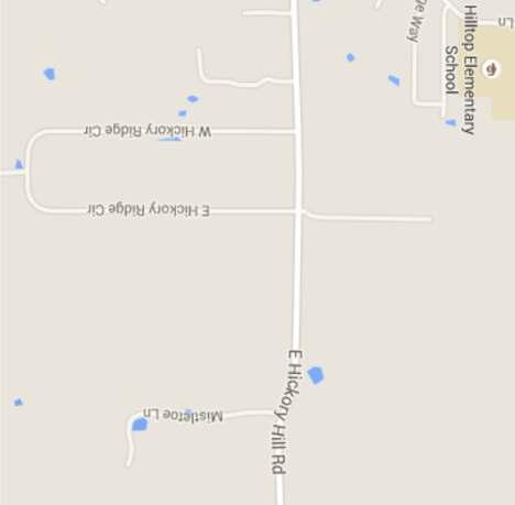
8 PLANNING AND ZONING COMMISSION STAFF REPORT Meeting Date: August 4, 2015 To: From: Chairman Walker and Members of the Planning and Zoning Commission Matt Jones, Director of Community Development Subject: New Business Item F-1 Minor Final Plat for Moilan Addition, Block A, Lot 1 Purpose: Consider and take appropriate action on a minor final plat for Lot 1, Block A, Moilan Addition. The request is for a final plat of previously unplatted tract of land. The subject property is located on the south side of E. Hickory Hill Rd., located at 800 E. Hickory Hill Rd., and zoned A (Agricultural District), in the Town of Argyle, Denton County, Texas. DMAC Family LTD, property owner/applicant. KAZ Surveying, surveyor. Project # P Existing Condition of Property: The subject property has been developed with a single family home and is mostly open pasture with a few mature trees scattered throughout the property. Adjacent Existing Land Uses and Zoning: North: South: East: West: Single family residential uses zoned A (Agricultural District) Single family residential uses zoned A (Agricultural District) Single family residential uses zoned A (Agricultural District) Single family residential uses zoned A (Agricultural District) Development Review Analysis: The subject property is currently zoned A (Agricultural District). The subject property is currently unplatted although a single family residence was constructed on site in 1938 per Denton County Central Appraisal District. During the review process it came to the attention of the Development Review Committee that the proposed lot does not meet the minimum requirements of the A (Agricultural District) zoning regulations of the Town Development Standards (TDS). The minimum lot requirements for A (Agricultural District) zoning are as follows: AREA REGULATIONS: A. Size of Lots: 1. Standard Lots: a. Minimum Lot Area - Five (5) acres. b. Minimum Lot Width - Three hundred feet (300') at the front property line.* c. Minimum Lot Depth - Three hundred feet (300'). 5 of 21
9 d. Average Lot Depth - Lots shall maintain an average lot depth that is not less than two (2) times the lot width as measured at the front property line. The proposed lot width ( ) does not meet the minimum lot width (300 ) of the A (Agricultural District) zoning regulations, therefore, the proposed plat must be considered for approval by the Planning and Zoning Commission. The Planning and Zoning Commission may grant a variance to the minimum lot width and depth for the approval of a minor final plat. The request is for a variance to the minimum lot width of 300. Recommendation: Town staff forwards this requests to you for consideration and appropriate action. Attachments: Site Map with zoning Aerial Photo Proposed minor final plat 6 of 21


10 SITE MAP WITH ZONING SITE 7 of 21
")
11 Aerial Photo Moilan Addition Final Plat (Minor) 8 of 21
12 9 of 21
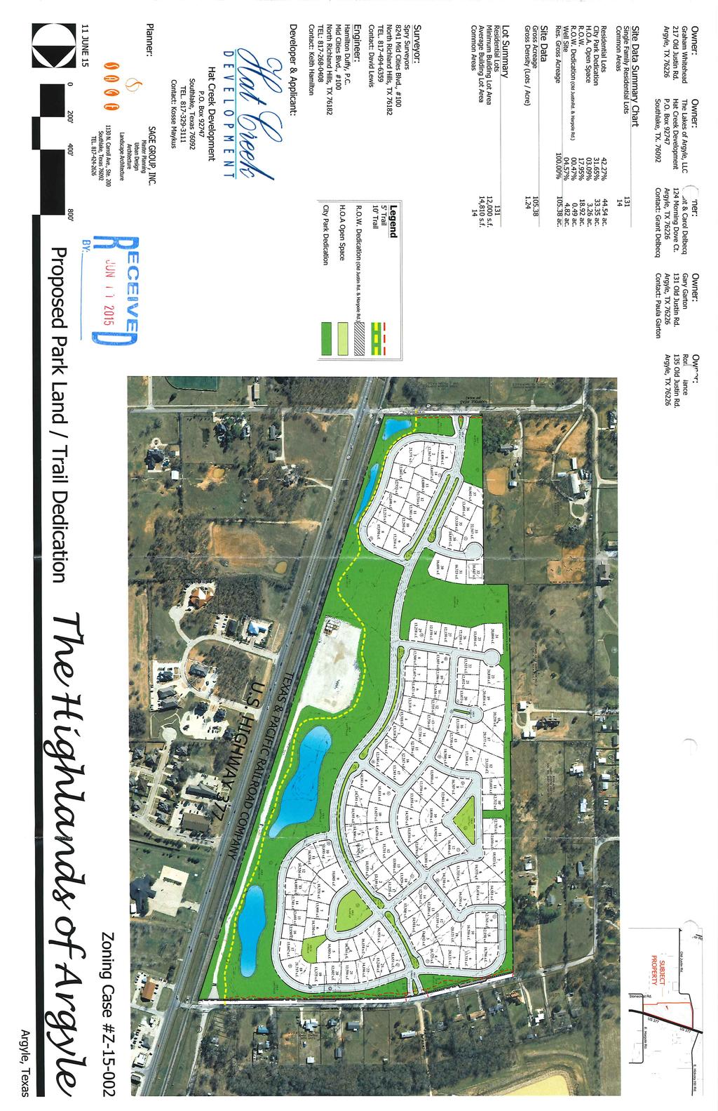
13 Meeting Date: August 4, 2015 PLANNING AND ZONING COMMISSION STAFF REPORT To: From: Subject: Chairman Walker and Members of the Planning and Zoning Commission Matt Jones, Director of Community Development Zoning Change from A and SF-2.5 to PD-SF-12 The Highlands of Argyle Purpose: Consider and take appropriate action on a zoning change request from A (Agricultural) and SF 2.5 (Single Family 2.5 Acre Estate District) to PD SF-12 (Planned Development-Single Family Residential Minimum 12,000 Square-foot lots) for The Highlands of Argyle, a proposed 131-lot residential subdivision on acres of land out of the Leonard White Survey, Abstract No. 1384, portions of which are legally described as Lot 1, Block A, Restless Acres; Lots 2R and 3, Block A, Vineyard Hills Subdivision Number 2; and Lots 3, 4, and 5, Block 1, Vineyard Hills Subdivision, and located on the west side of US Highway 377 and the Union Pacific Railroad, south of Old Justin Road and north of Harpole Road West, in the Town of Argyle, Denton County, Texas. Project # Z Existing Condition of Property: The majority of the property contains open pasture with gently rolling hills and clusters of mature trees in floodplain areas along the Graveyard Branch. Smaller clusters of mature trees are scattered throughout the acreage. A gas well pad site is situated along the east property line with an access road connecting the pad to Old Justin Road. Adjacent Existing Land Uses and Zoning: North: Single family residential uses zoned SF-1 (Single Family Residential 1-Acre Estate District) South: Single family and agricultural uses zoned A (Agricultural District) East: Residential, office and retail uses across the Union Pacific Railroad and US Hwy. 377 zoned OR (Office Retail) West: Single family and agricultural uses zoned A, SF-2.5, SF-1 and MH (Manufactured Home District) Development Review Analysis: The applicant proposes 131 single family residential lots with acres of open space (excluding the gas well pad and access road) on a total of Minimum lot size is 12,000 square feet. The average lot area is 14,810 square feet. Consistency with Future Land Use Plan: The subject property is designated as T3-A Railroad Transition on the Future Land Use Plan. The overall density calculations (1.24 units/acre) fall within the suitable category for the T3-A transect. The density proposed is in general compliance of the density guidelines of the Comprehensive Plan. The concept is also in general compliance with the lot size transition recommendations and the open space recommendations of the Comprehensive Plan. Tree Preservation: The applicant has provided a tree preservation plan with an aerial overlay as required by the Tree Preservation Requirements of the Town Development Standards. A detailed tree survey will be submitted with the final plat and construction plans for the development and shall meet the requirements of the tree preservation ordinance. 10 of 21
14 Infrastructure Adequacy: Water and sanitary sewer facilities are available at this site with access capacity. If approved, full civil construction plans for streets, drainage, water and sanitary sewer are required for submission at the time of final plat application. Drainage Analysis: Staff has reviewed the PD concept plan and has determined that compliance with all drainage requirements of the Town Developments Standards can be achieved at the time of preliminary and final plat. Design Standards: The applicant has proposed a variety of design standards as outlined in the PD Zoning narrative that exceed the minimum requirements of the Town Development Standards. Recommendation: Town staff recommends tabling the request to the September 1, 2015 Planning and Zoning Commission meeting. Attachments: Concept Plan Zoning Narrative 11 of 21
15 12 of 21
16 13 of 21
17 14 of 21
18 15 of 21
19 The Highlands of Argyle Zoning Narrative 14 April 2015 Hat Creek Development, Developer Sage Group, Inc., Land Planner A: Introduction: The Highlands of Argyle will be a master-planned residential community of quality homes, surrounded by extensively landscaped open spaces, in the central portion of the Town of Argyle, Texas. The intent of this development will be to contribute to and become a part of the coveted small-town atmosphere Argyle is known for, in a location also accessible to all the economic, social and cultural advantages offered by the greater Dallas- Fort Worth area. B: Influences on Development The project is located just southwest of the Old Town area, on the west side of the two, adjacent major arteries through the central portion of the town- US Highway 377 and the Railroad. While adjacency to a major road generally provides good exposure and access, because the railroad separates the property from US-377, access is limited to the two streets crossing the rail- Old Justin Road to the north and Harpole Road to the south. Because these at grade crossings are occasionally blocked by rail traffic, we feel it is important for the mobility needs of the project- and the surrounding community- to link these perimeter roads with a north/south connector road through the project, which would serve as a link between the two roads until such a time the proposed Collector road on the Town s Thoroughfare Plan, which is west of this property, is implemented. The exposure to the views of the community from US-377, as well as from the existing roads to the north and south, is also something we felt was important to consider in our planning. So, instead of erecting perimeter walls or fences- as so many developments do, effectively turning their back on the surrounding community- we propose to front our homes toward the community, separated only by generous, landscaped open space setbacks along that perimeter. Adjacency to these major arteries also brings, of course, the influence of the activity and noise they generate. The master plan responds to this by including a large, landscaped buffer area along the eastern boundary to provide enough separation to mitigate this influence. This area will also double by serving as the most public portion of the community, with an extensive, continuous pedestrian trail along the entire length, providing the Town of Argyle with a critical link in a planned major pedestrian access trail west of the 377/ Railroad corridor. It will allow the development, as well as the neighboring properties access to the most sought-after, modern amenity in a master-planned community today- walking trails and sidewalks. 16 of 21
20 Although the high-activity areas to the east are an influence we knew we needed to address in our planning, so too are the existing, quiet, larger lot areas to the west (ranging from half-acre lots to multiple acre estates), and the Master Plan, with increasing lot sizes to the west, and a 40 minimum landscaped buffer strip of open space has been built into the plan, to reflect our commitment to be sensitive to those western neighbors. The property is also influenced by an existing drainage-way, flowing from the west, bisecting the site and ultimately heading to the northeast corner. We have commissioned a hydrologic study of the entire drainage area, so that we can all be assured that- during a 100 year storm, flows along this drainage will not adversely affect either the homes to be built within The Highlands of Argyle, or homes in any of the neighboring properties- upstream or downstream. C: Master Planning Concept: The Master Plan has been designed to address the widely varying exposures (highway and rail noise to the east vs. quiet residential to the west) by placing minimum 12,000 s.f. and/or minimum 15,000 s.f. lots in the southern portion of the community and fronting to the east (buffered by an open space setback and drainage-way), and then layering larger, half acre lots in the western portion of the property (north of the creek), culminating with a minimum 40 greenway buffer and trail corridor between all residential lots and the neighboring properties. D: Land Development Criteria: Density: There shall be a maximum of 131 Single-Family Residential Lots on the acres within The Highlands of Argyle development, along with acres of open space, resulting in an overall maximum density of 1.24 units per acre. Lot Sizes: There shall be three separate categories of lots within The Highlands of Argyle. They shall be as follows: Lot Type SF-12 PD SF-15 PD SF-20 PD Minimum Lot Area 12,000 s.f. 15,000 s.f. 20,000 s.f. Min. Average Lot Area Minimum Lot Width Minimum Lot Depth 13,500 s.f. 16,500 s.f. 22,500 s.f A table on the Development Standards and Fencing Plan exhibit compares these proposed PD Standards with the normal Town of Argyle Development Standards for SF-10 & SF of 21
21 Setbacks and Lot Coverage: The setbacks and lot coverage criteria for The Highlands of Argyle are as follows: Lot Type SF-12 PD SF-15 PD SF-20 PD Front Yard Setback Side Yard Setback Street Side Setback 15, 25 Key Lot 15, 25 Key Lot 20 Rear Yard Setback Max. Lot Coverage* 45% 45% 40% *Lot Coverage defined as percentage of site within the perimeter walls of all structures. Open Space: The defining feature of The Highlands of Argyle community will be the abundance of preserved Open Space areas. Over 33% of the site will be dedicated to Open Space. All streets adjacent to the open space lots will be tree-lined, and every attempt will be made to save quality existing trees within these areas. Overall, there shall be a minimum of 1 tree for every 2,000 s.f. of open space, which totals over 760 trees. All open space areas will be fully maintained by The Highlands of Argyle Homeowners Association. Street Standards: All streets in The Highlands of Argyle will be constructed within public right of ways, of concrete and built to meet town standards. The north/south collector shall be no less than 36 wide (in a 70 ROW), and the local streets shall be no less than 30 wide (in a 50 ROW). Sidewalks and Trails: A four foot sidewalk shall be built by the homebuilder in the ROW of the adjacent street as the homes are built. A ten foot community trail shall be built by the developer where indicated on the zoning concept plan, and a 5 trail will be built elsewhere in the Open space corridors, as shown. Such trails shall be built in phases, as the development progresses. Parking: A minimum of four off-street parking spaces will be provided on each lot, typically two enclosed, two in the drive. The area adjacent to the eastern open space/ park dedication has been designed with an abundance of single loaded streets, allowing for ample on-street visitor parking. Lot Grading: All lots shall be graded to meet minimum town standards. Tree Preservation: Every attempt will be made to save as many of the existing quality trees on the site, particularly in the drainage areas. Trees at the entry and along the perimeter open space areas will be surveyed to allow for maximum preservation. Fencing: All perimeter fencing will be as shown on the Fencing Plan; all lots siding or backing to open space lots shall be fenced with a 5 high ornamental metal fence. All front yard fences, parallel to the ROW, shall also be of 5 ornamental metal. Fencing between lots shall be 6 high, stained cedar wood fence, with a cap. 18 of 21
22 Entryways: The primary project entries shall be from Old Justin Road and from Harpole Road. Entry monuments/ masonry walls/ fences will be built at each entry, and such entries will be fully landscaped with turf, trees, shrubbery and will be irrigated. The entry areas will be fully maintained by The Highlands of Argyle Homeowners Association. E: Minimum Exterior Construction and Design Standards: The Highlands of Argyle will meet or exceed the standards contained within the Town of Argyle Zoning Ordinance, specifically those enumerated in Section In addition, we will require the following additional standards for all homes to be built in The Highlands of Argyle: Minimum Home Area: There shall be the following minimum standards for home sizes to be built within The Highlands of Argyle: Lot Type SF-12 PD SF-15 PD SF-20 PD Minimum Home Area 2,500 s.f. 2,750 3,000 s.f. Maximum Height: The maximum height of all homes in The Highlands of Argyle shall be two and one-half stories, or 35. Architectural Control: An Architectural Control Committee will be created by the developer and will have the authority to institute architectural standards and approve all plans prior to approval for construction. Prohibition of Building Repetition: The same building elevation and/or color palette shall not be repeated on the adjacent 4 neighboring lots and the lots across the street from those lots (up to 9 lots on each side of the street, as many as 18 total) within the same block. A change in elevation can be achieved by a combination of the use of different materials (i.e. a change in brick or stone color, or type), a varied window pattern (arched, peaked, flat, eyebrow, etc.) and/or a change to eave, roof or fenestration configuration; or a completely different elevation design and layout using similar materials. Front Elevation Articulation: A minimum of 25% of the Front Elevation of all homes shall be set back a minimum of an additional 3 feet from the normal Front Yard Setback. Exterior Materials: All homes shall be finished with a minimum of 80% masonry materials, exclusive of doors and windows. Windows: Low E vinyl windows. All front elevation windows shall be divided unless an alternative is dictated by architectural style. 19 of 21
23 Front Door: Minimum 8 height, decorative architectural style. Driveways and Walkups: Salt finished, brushed concrete or exposed aggregate. Garage Location & Exposure: A minimum of 2 garage spaces shall be built with each home. All garages shall either be: 1) Side loaded, 2) Rear located, front facing garages separate from the primary structure (with 5 side and rear lot line setbacks), 3) a Porte Cochere style driveway/ garage court, screened from view from the street, or 4) Three car garages where the third, front-facing garage door is located at least 20 feet behind the Front Building Setback (behind the 2, side-facing garage doors). No J-swings of regular Front-facing garages shall be allowed. Garage Doors: Wood clad, painted or stained depending on style of house. Roof Pitch: Minimum roof pitches shall be 8:12, unless architectural style dictates otherwise. No flat roofs shall be allowed. Roof Material: 30 year, high performance composite roof, or metal standing seam, or tile. Mailboxes: All mailboxes shall be uniform, and have an antique, cast iron appearance. Mechanical Equipment: All mechanical equipment, such as HVAC condensers, shall be located away from the street-side elevation. Retaining Walls: All retaining walls shall be constructed of reinforced concrete, natural stone or engineered stone. Wooden retaining walls are not permitted. Landscaping: All lots shall be fully landscaped with a combination of trees, shrubs, flowering plants and turf grass. All beds shall be mulched with natural materials, and be edged with metal, stone or brick. Each home will be required to have a minimum of two, 3-1/2 caliper shade trees planted in the front yard. An automatic irrigation system is required for all landscaped areas visible from the right-of-way, open spaces and other private properties adjacent to The Highlands of Argyle. F: Parkland Dedication: Concurrent with the platting of The Highlands of Argyle, in phases, we will dedicate a Park Site and Trail ROW/ Improvements to the Town, as illustrated on the Parkland and Trail Dedication exhibit. For each phase of the development, we propose to build, within the park area to be dedicated to the Town, a 10 concrete trail from our southern boundary along Harpole Road, to our northern boundary along Old Justin Road, generally as shown on the exhibit. In addition, an area suitable for development of a playground/ park will part of the dedicated area. The total area to be ultimate dedicated is approximately acres. The Highlands of Argyle will also commit to maintain these areas and improvements for a period of not less than 3 years from 20 of 21
24 installation/ dedication, or until such time as the Town is able to assume such maintenance, whichever happens first. G. Open Space: The Highlands of Argyle will have, as its primary defining feature, an abundant amount of visible, usable and accessible Open Space, for the use and enjoyment of the residents. The total area reserved for Open Space on the site, including the proposed park dedication, is acres, over 33% of the total property. This amount excludes 4.82 acres that is currently being used as a site for a Gas Well, and access road. Although the Gas Well is a temporary use, which will ultimately go away and be converted into additional usable open space, it is currently not accessible and therefore was not included within the Open Space area. 21 of 21
NOTICE OF THE REGULAR MEETING OF THE PLANNING & ZONING COMMISSION Tuesday, April 4, 2017 REGULAR MEETING AGENDA 6:30 PM
 NOTICE OF THE REGULAR MEETING OF THE PLANNING & ZONING COMMISSION Tuesday, April 4, 2017 Notice is hereby given of the Regular Meeting of the Planning & Zoning Commission beginning at 6:30 p.m. Tuesday,
NOTICE OF THE REGULAR MEETING OF THE PLANNING & ZONING COMMISSION Tuesday, January 5, 2016 REGULAR MEETING AGENDA 6:30 PM
 NOTICE OF THE REGULAR MEETING OF THE PLANNING & ZONING COMMISSION Tuesday, January 5, 2016 Notice is hereby given of the Regular Meeting of the Planning & Zoning Commission beginning at 6:30 p.m. Tuesday,
Exhibit A-1. Piney Creek Bend Planned Development
 Exhibit A-1 Piney Creek Bend Planned Development A. Purpose and Intent The Piney Creek Bend PD is composed of approximately 90.91 acres, as described in Exhibit D (Field Notes). The development of this
Development Plan DP13-3 (Arlington Lofts) Planning and Zoning Meeting Date: Document Being Considered: Ordinance
 Planning and Zoning Meeting Date: Document Being Considered: Ordinance") Staff Report Development Plan DP13-3 (Arlington Lofts) Planning and Zoning Meeting Date: 6-19-13 Document Being Considered: Ordinance RECOMMENDATION Following the public hearing, consider Development Plan
Staff Report Development Plan DP13-3 (Arlington Lofts) Planning and Zoning Meeting Date: 6-19-13 Document Being Considered: Ordinance RECOMMENDATION Following the public hearing, consider Development Plan
M E M O R A N D U M. Planning and Zoning Commission. Daniel Turner, Planner I
 M E M O R A N D U M Meeting Date: April 27, 2015 Item No. E-1 To: From: Planning and Zoning Commission Daniel Turner, Planner I Subject: Consider approval of a Final Plat for Gean Estates, Phase I, a proposed
SPECIAL ZONING DISTRICTS
 SPECIAL ZONING DISTRICTS 5.01 5.99 RESERVED 5.100 PLANNED DEVELOPMENTS: Purpose: This district is intended to accommodate unified design of residential, commercial, office, professional services, retail
525 Yacht Club Road Oak Point, Texas p f
 ZONING VCM Prestonwood Polo Development, Ltd has re-zoned the 97.08 acre Prestonwood Polo Club property into 22 exclusive home sites overlooking lush 3 green polo fields. Careful attention has been paid
City of Colleyville City Council Agenda Briefing
 City of Colleyville City Council Agenda Briefing City Hall 100 Main Street Colleyville, Texas 76034 www.colleyville.com Agenda Number 5a Agenda Date 01/06/2015 Number Ordinance O-14-1942 Type Ordinance
Cover Letter with Narrative Statement
 Cover Letter with Narrative Statement March 31, 2017 rev July 27, 2017 RE: Rushton Pointe Residential Planned Unit Development Application for Public Hearing for RPUD Rezone PL2015 000 0306 Mr. Eric Johnson,
Appendix J - Planned Unit Development (PUD)
") Appendix J - Planned Unit Development (PUD) Intent and Purpose The purpose of the PUD is: 1. To provide development that is consistent with the Comprehensive Land Use Plan and promote the goals and objectives
Appendix J - Planned Unit Development (PUD) Intent and Purpose The purpose of the PUD is: 1. To provide development that is consistent with the Comprehensive Land Use Plan and promote the goals and objectives
Initial Subdivision Applications Shall Include the Following:
 Initial Subdivision Applications Shall Include the Following: 1) Subdivision Application Form: completely filled out (12 copies) 2) Plat: The Plat must adhere to the requirements set forth in the Town
PLANNED DEVELOPMENT DISTRICT STANDARDS. Cadence Site
 PLANNED DEVELOPMENT DISTRICT STANDARDS Cadence Site A Planned Development District 1. Statement of General Facts, Conditions and Objectives Property Size: Approximately 57.51 Acres York County Tax Map
M E M O R A N D U M. Meeting Date: October 23, Item No. F-1. Planning and Zoning Commission. Daniel Turner, Planner I
 M E M O R A N D U M Meeting Date: October 23, 2017 Item No. F-1 To: From: Subject: Planning and Zoning Commission Daniel Turner, Planner I PUBLIC HEARING: Consider a recommendation of a of Planned Development
ARTICLE 15. RULES, REGULATIONS AND DEFINITIONS
 ARTICLE 15. RULES, REGULATIONS AND DEFINITIONS Section 1. Interpretation and Construction: The following rules and regulations regarding interpretation and construction of the Ulysses-Grant County, Kansas,
M E M O R A N D U M. Meeting Date: May 1, Item No. H-4. Steve Polasek, Interim City Manager. David Hawkins, Senior Planner
 M E M O R A N D U M Meeting Date: May 1, 2012 Item No. H-4 To: From: Subject: Steve Polasek, Interim City Manager David Hawkins, Senior Planner PUBLIC HEARING: Consider an ordinance approving a planned
M E M O R A N D U M. Meeting Date: April 19, Item No. H-2. Mark Hafner, City Manager. Michele Berry, Planner II
 M E M O R A N D U M Meeting Date: April 19, 2016 Item No. H-2 To: From: Subject: Mark Hafner, City Manager Michele Berry, Planner II PUBLIC HEARING: Consider an ordinance approving a Specific Use Permit
PLANNED DEVELOPMENT DISTRICT A ACRE TRACT KNOWN AS GEAN ESTATES CITY OF KELLER, TARRANT COUNTY TEXAS
 PLANNED DEVELOPMENT DISTRICT A 123.359 ACRE TRACT KNOWN AS GEAN ESTATES CITY OF KELLER, TARRANT COUNTY TEXAS A. Exhibit A Development Regulations B. Exhibit B Legal Description C. Exhibit C Conceptual
PLANNED DEVELOPMENT DISTRICT A ACRE TRACT KNOWN AS GEAN ESTATES CITY OF KELLER, TARRANT COUNTY TEXAS
 PLANNED DEVELOPMENT DISTRICT A 105.026 ACRE TRACT KNOWN AS GEAN ESTATES CITY OF KELLER, TARRANT COUNTY TEXAS A. Exhibit A Development Regulations B. Exhibit B Legal Description C. Exhibit C Conceptual
Marion County Board of County Commissioners
 Marion County Board of County Commissioners Date: 12/2/2015 P&Z: 11/30/2015 BCC: 12/16/2015 Item Number 151210SU Type of Application Special Use Permit Request To establish a Clay Electric Co-Operative
UPPER MOUNT BETHEL TOWNSHIP NORTHAMPTON COUNTY, PENNSYLVANIA
 UPPER MOUNT BETHEL TOWNSHIP NORTHAMPTON COUNTY, PENNSYLVANIA JOINDER DEED / LOT CONSOLIDATION TOWNSHIP REVIEW PROCESS When accepting proposed Joinder Deeds / Lot Consolidations, review the Joinder Deed
CHAPTER34 PRUD - PLANNED RESIDENTIAL UNIT DEVELOPMENT
 CHAPTER34 PRUD - PLANNED RESIDENTIAL UNIT DEVELOPMENT 17-34-1 17-34-2 17-34-3 17-34-4 17-34-5 17-34-6 17-34-7 17-34-8 17-34-9 Purpose Planned Residential Unit Development Defined Planned Residential Unit
RECOMMENDATION Following the public hearing, consider Zoning Case PD14-16, with a Development Plan.
 Staff Report Zoning Case PD14-16 (Helzer Tract) Planning and Zoning Meeting Date: 12-17-14 Document Being Considered: Ordinance RECOMMENDATION Following the public hearing, consider Zoning Case PD14-16,
ACTION FORM BRYAN CITY COUNCIL
 ACTION FORM BRYAN CITY COUNCIL DATE OF COUNCIL MEETING: July 8, 2014 DATE SUBMITTED: June 17, 2014 DEPARTMENT OF ORIGIN: Development Services SUBMITTED BY: Maggie Dalton MEETING TYPE: CLASSIFICATION: ORDINANCE:
MINUTES OF THE WORK STUDY MEETING OF THE QUEEN CREEK PLANNING AND ZONING COMMISSION AGENDA
 November 14, 2012, Page 1 of 5 MINUTES OF THE WORK STUDY MEETING OF THE QUEEN CREEK PLANNING AND ZONING COMMISSION WHEN: WEDNESDAY, NOVEMBER 14, 2012 WHERE: TOWN HALL COUNCIL CHAMBERS TIME: 6:00 p.m. Pursuant
ORDINANCE NO. 208 BE IT ORDAINED BY THE CITY COUNCIL OF THE CITY OF UNIVERSITY HEIGHTS, JOHNSON COUNTY, IOWA:
 ORDINANCE NO. 208 AN ORDINANCE AMENDING ORDINANCE NO. 79 (ZONING) TO CREATE A COMMERCIAL HOTEL ZONE AND PERMIT DEVELOPMENT PURSUANT TO A COMMERCIAL HOTEL PUD BE IT ORDAINED BY THE CITY COUNCIL OF THE CITY
8.5.1 R1, Single Detached Residential District
 8.5.1 R1, Single Detached Residential District The purpose of this district is to provide for residential development in the form of single detached dwellings. Dwelling, Single Detached Home Business,
TOWN OF ORO VALLEY PLANNING & ZONING COMMISSION MEETING DATE: December 6, 2011
 PLANNING & ZONING COMMISSION MEETING DATE: December 6, 2011 TO: FROM: SUBJECT: PLANNING & ZONING COMMISSION Matt Michels, Senior Planner mmichels@orovalleyaz.gov; tel. 229-4822 Public Hearing: Rancho de
Article 3. SUBURBAN (S-) NEIGHBORHOOD CONTEXT
 NEIGHBORHOOD CONTEXT") Article 3. SUBURBAN (S-) NEIGHBORHOOD CONTEXT this page left intentionally blank Contents ARTICLE 3. SUBURBAN (S-) NEIGHBORHOOD CONTEXT DIVISION 3.1 NEIGHBORHOOD CONTEXT DESCRIPTION...3.1-1 Section 3.1.1
Article 3. SUBURBAN (S-) NEIGHBORHOOD CONTEXT this page left intentionally blank Contents ARTICLE 3. SUBURBAN (S-) NEIGHBORHOOD CONTEXT DIVISION 3.1 NEIGHBORHOOD CONTEXT DESCRIPTION...3.1-1 Section 3.1.1
1. APPLICANT: The City of Overland Park is the applicant for this request.
 8. UNIFIED DEVELOPMENT ORDINANCE AMENDMENT - ZRR 2590 - Residential Neighborhood District 1. APPLICANT: The City of Overland Park is the applicant for this request. 2. REQUESTED ACTION: The applicant is
EDGERTON CITY HALL PLANNING COMMISSION MEETING REGULAR SESSION March 12, 2019
 EDGERTON CITY HALL PLANNING COMMISSION MEETING REGULAR SESSION The met in regular session with Chair John Daley calling the meeting to order at 7:00 p.m. All present participated in the Pledge of Allegiance.
CITY OF MERCED SMALL LOT SINGLE-FAMILY HOME DESIGN GUIDELINES
 CITY OF MERCED SMALL LOT SINGLE-FAMILY HOME DESIGN GUIDELINES Development Services Department Planning and Permitting Adopted August 15, 2005 SMALL LOT SINGLE FAMILY HOME GUIDELINES A. Purpose and Applicability.
(a) Commercial uses on Laurel Avenue, abutting the TRO District to the
 Commercial uses on Laurel Avenue, abutting the TRO District to the") 32X Zoning Code 150.36 TRANSITIONAL RESIDENTIAL OVERLAY DISTRICT. (A) Intent and purpose. (1) It is the intent of the Transitional Residential Overlay District (hereinafter referred to as the "TRO District")
32X Zoning Code 150.36 TRANSITIONAL RESIDENTIAL OVERLAY DISTRICT. (A) Intent and purpose. (1) It is the intent of the Transitional Residential Overlay District (hereinafter referred to as the "TRO District")
PRIMUS TRACT MOUNT PLEASANT, SOUTH CAROLINA
 DEVELOPMENT GUIDELINES FOR PRIMUS TRACT MOUNT PLEASANT, SOUTH CAROLINA Date February 18, 2015 PLANNING COMMISSION SUBMITTAL Owner/Developer: American Star Development SC, LLC P.O. Box 211 Sullivans Island,
Rezoning. Rezone a portion of the property from CD to RF-9 to allow subdivision into approximately 8 small single family lots with rear lane access.
 City of Surrey PLANNING & DEVELOPMENT REPORT File: Rezoning Proposal: Rezone a portion of the property from CD to RF-9 to allow subdivision into approximately 8 small single family lots with rear lane
PLANNING AND ZONING COMMISSION FEBRUARY 20, :30 P.M. PLANNING AND ZONING MEMBERS PRESENT MEMBERS ABSENT: STAFF PRESENT:
 PLANNING AND ZONING COMMISSION FEBRUARY 20, 2018 5:30 P.M. PLANNING AND ZONING MEMBERS PRESENT Chair Lester Fettig Omar Crisp Paulino Castillo Lydia Alaniz Bryant Ward Jessica Walker Jeremy Langley MEMBERS
4.2 RESIDENTIAL ZONING DISTRICTS
 4.2 RESIDENTIAL ZONING DISTRICTS A. Purpose: To define regulations and standards for each residential zoning district in the City. The following sections identify uses, regulations, and performance standards
PLANNING COMMISSION REPORT Regular Agenda -Public Hearing Item
 PDP-13-00518 Item No. 3B- 1 PLANNING COMMISSION REPORT Regular Agenda -Public Hearing Item PC Staff Report 2/24/14 ITEM NO. 3B PRELIMINARY DEVELOPMENT PLAN FOR HERE @ KANSAS; 1101 INDIANA ST (SLD) PDP-13-00518:
ARTICLE 3 DEFINITIONS
 Sections: 3-1 Rules of Construction 3-2 Definitions ARTICLE 3 DEFINITIONS SECTION 3-1 RULES OF CONSTRUCTION 3-101. a. The language set forth in these regulations shall be interpreted in accordance with
Planning and Zoning Commission STAFF REPORT REQUEST. DSA : Zone Change from R-3 (Multi-Family Residential) to B-4 (Community Services).
 to B-4 (Community Services).") Planning and Zoning Commission STAFF REPORT AGENDA # TO: FROM: PLANNING AND ZONING COMMISSION Joseph Horn, City Planner MEETING DATES: August 4, 2016 SUBJECT: Gino Tarantini zone change requests REQUEST
Planning and Zoning Commission STAFF REPORT AGENDA # TO: FROM: PLANNING AND ZONING COMMISSION Joseph Horn, City Planner MEETING DATES: August 4, 2016 SUBJECT: Gino Tarantini zone change requests REQUEST
PLANNING AND ZONING COMMISSION AGENDA MEMORANDUM
 City and County of Broomfield, Colorado PLANNING AND ZONING COMMISSION AGENDA MEMORANDUM To: Planning and Zoning Commission From: John Hilgers, Planning Director Anna Bertanzetti, Principal Planner Meeting
A G E N D A. Administrative Review Board City Council Chambers 800 Municipal Drive, Farmington, NM February 9, 2017 at 6:00 p.m.
 A G E N D A Administrative Review Board City Council Chambers 800 Municipal Drive, Farmington, NM February 9, 2017 at 6:00 p.m. Item No. 1 Call Meeting to Order Page 2 Approval of the Agenda 3 Approval
A. Preserve natural resources as identified in the Comprehensive Plan.
 1370.08 Conservation Residential Overlay District. Subd. 1 Findings. The City finds that the lands and resources within the Conservation Residential Overlay District are a unique and valuable resource
Chapter SPECIAL USE ZONING DISTRICTS
 Chapter 20.20 Sections: 20.20.010 Urban Transition (U-T) Zoning District 20.20.020 Planned Development (P-D) Zoning Districts 20.20.010 Urban Transition (U-T) Zoning District A. Purpose. The purpose of
DEVELOPMENT STANDARDS FOR RESIDENTIAL PROJECTS RESIDENTIAL BUILDING TYPES: APPROPRIATE ZONES AND DENSITIES 2-1
 2 DEVELOPMENT STANDARDS FOR RESIDENTIAL PROJECTS RESIDENTIAL BUILDING TYPES: APPROPRIATE ZONES AND DENSITIES 2-1 This Chapter presents the development standards for residential projects. Section 2.1 discusses
PLANNED UNIT DEVELOPMENT & SUBDIVISION STAFF REPORT Date: November 17, 2016
 PLANNED UNIT DEVELOPMENT & SUBDIVISION STAFF REPORT Date: November 17, 2016 DEVELOPMENT NAME SUBDIVISION NAME LOCATION Autonation Ford of Mobile Autonation Ford of Mobile Subdivision 901, 909, and 925
Proposed Overland Park Kansas Ordinance RE-1 Residential Estates Community
 18.171 RE-1 Residential Estate Community 18.171.010 Statement of intent. The zoning of property as RE-1, (Residential Estates Community, 1 dwelling unit per Gross acre density), is intended to provide
I. Requirements for All Applications. C D W
 108-16.1. Application checklists. Checklist for Required Submissions to the Planning Board or Zoning Board of Adjustment of Monroe Township All required submissions are to be made to the Administrative
Financial Impact Statement There are no immediate financial impacts associated with the adoption of this report.
 STAFF REPORT Planning and Development Department Subject: Application by RYC Property to rezone a portion of lands on John Murray Dr. and Megan Lynn Dr. from R2 to R3 and to enter into a Development Agreement
PLANNED UNIT DEVELOPMENT STAFF REPORT Date: October 19, 2017
 PLANNED UNIT DEVELOPMENT STAFF REPORT Date: October 19, 2017 DEVELOPMENT NAME LOCATION Custom Boat Storage 3975 Demetropolis Road (East side of Demetropolis Road, 0.2± miles South of Halls Mill Road.)
DRAFT FOR PUBLIC HEARING (rev. March, 2016)
") Chapter 200. ZONING Article VI. Conservation/Cluster Subdivisions 200-45. Intent and Purpose These provisions are intended to: A. Guide the future growth and development of the community consistent with
Chapter 200. ZONING Article VI. Conservation/Cluster Subdivisions 200-45. Intent and Purpose These provisions are intended to: A. Guide the future growth and development of the community consistent with
Planned Unit Development (PUD). Sections:
. Sections:") Chapter 19.07. Planned Unit Development (PUD). Sections: 19.07.01. Purpose. 19.07.02. PUD Definition and Design Compatibility. 19.07.03. General PUD Standards. 19.07.04. Underlying Zones. 19.07.05. Permitted
Chapter 19.07. Planned Unit Development (PUD). Sections: 19.07.01. Purpose. 19.07.02. PUD Definition and Design Compatibility. 19.07.03. General PUD Standards. 19.07.04. Underlying Zones. 19.07.05. Permitted
PLANNING COMMISSION Thursday, September 5, :00 p.m. Council Chambers, Administration Building 100 Ribaut Road, Beaufort, South Carolina
 PLANNING COMMISSION Thursday, September 5, 2013 6:00 p.m. Council Chambers, Administration Building 100 Ribaut Road, Beaufort, South Carolina In accordance with South Carolina Code of Laws, 1976, Section
A. Land Use Relationships
 Chapter 9 Land Use Plan A. Land Use Relationships Development patterns in Colleyville have evolved from basic agricultural and residential land uses, predominate during the early stages of Colleyville
Composition of traditional residential corridors.
 Page 1 of 7 St. Petersburg, Florida, Code of Ordinances >> PART II - ST. PETERSBURG CITY CODE >> Chapter 16 - LAND DEVELOPMENT REGULATIONS >> SECTION 16.20.060. CORRIDOR RESIDENTIAL TRADITIONAL DISTRICTS
Section 7.01 Area Regulations
 SECTION 7: AREA, YARD AND FENCE REGULATIONS Section 7.01 Area Regulations Except as hereinafter provided, no building or structure or part thereof shall be erected, altered or converted for any use permitted
AN ORDINANCE AMENDING THE CITY ZONING ORDINANCE AND THE OFFICIAL CODE OF THE CITY OF CLARKSVILLE RELATIVE TO CLUSTER OPTION DEVELOPMENTS
 ORDINANCE 74-2012-13 AN ORDINANCE AMENDING THE CITY ZONING ORDINANCE AND THE OFFICIAL CODE OF THE CITY OF CLARKSVILLE RELATIVE TO CLUSTER OPTION DEVELOPMENTS BE IT ORDAINED BY THE CITY COUNCIL OF THE CITY
the conditions contained in their respective Orders until January 1, 2025, at the discretion of the Director of Planning, Property and Development.
 Part 4: Use Regulations Temporary Uses and Structures Purpose the conditions contained in their respective Orders until January 1, 2025, at the discretion of the Director of Planning, Property and Development.
City of Valdosta Land Development Regulations
 Chapter 214 Standards Applying to All Districts Section 214-1 Dimensional Standards of Zoning Districts Dimensional standards for zoning districts are summarized in Tables 1, 2 and 3. See Chapter 6 for
APPLICATION FOR MAJOR SUBDIVISION APPROVAL (PRELIMINARY PLAT)
") 209 S. Main Street Marysville, Ohio 43040 Phone: (937) 645-7350 Fax: (937) 645-7351 www.marysvilleohio.org APPLICATION FOR MAJOR SUBDIVISION APPROVAL (PRELIMINARY PLAT) *** IMPORTANT INFORMATION ~ Please
209 S. Main Street Marysville, Ohio 43040 Phone: (937) 645-7350 Fax: (937) 645-7351 www.marysvilleohio.org APPLICATION FOR MAJOR SUBDIVISION APPROVAL (PRELIMINARY PLAT) *** IMPORTANT INFORMATION ~ Please
CHAPTER 26 PLANNING AND ZONING ARTICLE VII. MOBILE HOMES AND RECREATIONAL VEHICLE (RV) PARKS. Recreational Vehicle (RV) Park Development Standards
 PARKS. Recreational Vehicle (RV) Park Development Standards") CHAPTER 26 PLANNING AND ZONING ARTICLE VII. MOBILE HOMES AND RECREATIONAL VEHICLE (RV) PARKS. Section 26-VII-1. Section 26-VII-2. Section 26-VII-3. Section 26-VII-4. Section 26-VII-5. Purpose Permitted
CHAPTER 26 PLANNING AND ZONING ARTICLE VII. MOBILE HOMES AND RECREATIONAL VEHICLE (RV) PARKS. Section 26-VII-1. Section 26-VII-2. Section 26-VII-3. Section 26-VII-4. Section 26-VII-5. Purpose Permitted
SPEAR S RANCH ON SALADO CREEK ARCHITECTURAL CONTROL COMMITTEE IMPROVEMENT GUIDELINES
 SPEAR S RANCH ON SALADO CREEK ARCHITECTURAL CONTROL COMMITTEE IMPROVEMENT GUIDELINES These GUIDELINES are a summary of the DECLARATION plus any additional and/or adjusted requirements ADOPTED by the ACC
ARTICLE 5.0 SCHEDULE OF REGULATIONS
 ARTICLE 5.0 SCHEDULE OF REGULATIONS Section 5.101 Table of Dimensional Standards by District. Dimensional Standards AG AG with sewer Districts Rural Residential Business Other SF SF with sewer R-1 R-1
For Sale 50 SOUTH QUEEN STREET MAYTOWN, PA Industrial/Commercial Realtors
 For Sale 717.293.4477 Industrial/Commercial Realtors 50 SOUTH QUEEN STREET MAYTOWN, PA 17550 1853 William Penn Way Lancaster, PA 17601 717.293.4477 www.highassociates.com For Sale 717.293.4477 Office/
A. CONSIDERATION OF THE UNAPPROVED MINUTES OF DECEMBER 11, 2018
 I. CALL TO ORDER OFFICIAL AGENDA PLANNING & ZONING COMMISSION CITY OF STARKVILLE, MISSISSIPPI MEETING OF TUESDAY, JANUARY 8, 2018 1ST FLOOR CITY HALL COURT ROOM 110 WEST MAIN STREET AT 5:30 PM II. III.
DEVELOPMENT DEPARTMENT STAFF REPORT THE PARK AT 5 TH
 DEVELOPMENT DEPARTMENT STAFF REPORT ARB Meeting Date: July 3, 2018 Item #: _PZ2018-293_ THE PARK AT 5 TH Request: Site Address: Project Name: Parcel Number: Applicant: Proposed Development: Current Zoning:
Chapter Planned Residential Development Overlay
 Chapter 19.29 Planned Residential Development Overlay Sections 010 Purpose 020 Scope 030 Definitions 030 Minimum Size 040 Allowable Uses 050 Minimum Development Standards 060 Density Bonus 070 Open Space
CITY OF CEDAR HILL CITY COUNCIL AGENDA ITEM
 Public Hearing #2 Agenda Date: September 9, 2014 CITY OF CEDAR HILL CITY COUNCIL AGENDA ITEM Agenda Item Wording: Case No. 2014-26 CONDUCT A PUBLIC HEARING and consider a request for Conditional Use Permit
CITY OF ALBERT LEA PLANNING COMMISSION ADVISORY BOARD
 CITY OF ALBERT LEA PLANNING COMMISSION ADVISORY BOARD 9/1/2015, 5:30 p.m. City Council Chambers AGENDA A. CALL TO ORDER AND ROLL CALL B. APPROVAL OF THE AGENDA C. APPROVAL OF MINUTES 1. PC Minutes from
ARTICLE 143. PD 143.
 ARTICLE 143. PD 143. SEC. 51P-143.101. LEGISLATIVE HISTORY. PD 143 was established by Ordinance No. 17685, passed by the Dallas City Council on February 2, 1983. Ordinance No. 17685 amended Ordinance No.
PUD 42 - Warner Ranch PUD - Amend. 2 Item No. 4B ZONING ZON
 PUD 42 - Warner Ranch PUD - Amend. 2 Item No. 4B ZONING ZON1210-001 CASE PLANNER: Steve Hopkins REQUEST: Approval of PUD 42 - Warner Ranch PUD - Amend. 2 ZONING AT TIME OF APPLICATION: PUD 42 CURRENT USE
Article XIII-A. A-1000-M Apartment District Regulations
 . Sec. 1. Use regulations. In the A-1000-M Apartment District, no land shall be used and no building shall be erected for or converted to any use other than: (e) Apartments in compliance with all provisions
MINUTES JOINT MEETING LINCOLN COUNTY and SIOUX FALLS PLANNING COMMISSIONS 7:00 pm August 10, 2011
 MINUTES JOINT MEETING LINCOLN COUNTY and SIOUX FALLS PLANNING COMMISSIONS 7:00 pm August 10, 2011 Commissioners Room - Lincoln County Court House A joint meeting of the Lincoln County and Sioux Falls Planning
1. Roll Call. 2. Minutes a. September 24, 2018 Special Joint Meeting with Clay County Planning Commission. 3. Adoption of the Agenda
 1. Roll Call City of Vermillion Planning Commission Agenda 5:30 p.m. Regular Meeting Tuesday, October 9, 2018 City Council Chambers 2 nd Floor City Hall 25 Center Street Vermillion, SD 57069 2. Minutes
Department of Planning & Development Services
 Department of Planning & Development Services S T A F F R E P O R T February 9, 2015 CASE NO: PROJECT: EXECUTIVE SUMMARY: ZA14-154 Plat Revision for Lots 25R-1A, 25R-1B and 25R-1C, Block 1, Woodland Heights
Town of Cary, North Carolina Rezoning Staff Report 14-REZ-24 Indian Wells Road Properties Town Council Meeting November 20, 2014
 Town of Cary, North Carolina Rezoning Staff Report 14-REZ-24 Indian Wells Road Properties Town Council Meeting November 20, 2014 REQUEST To amend the Town of Cary Official Zoning Map by revising a condition
Chapter Residential Mixed Density Zone
 Chapter 19.16 Residential Mixed Density Zone 19.16.010 Purpose and Intent 19.16.020 Permitted Uses 19.16.030 Accessory Permitted Uses 19.16.040 Secondary Permitted Uses 19.16.050 Conditional Uses 19.16.060
MIDDLETOWN TOWNSHIP PLANNING COMMISSION REGULAR MEETING MIDDLETOWN MUNICIPAL BUILDING WEDNESDAY, November 2, 2016
 MIDDLETOWN TOWNSHIP PLANNING COMMISSION REGULAR MEETING MIDDLETOWN MUNICIPAL BUILDING WEDNESDAY, November 2, 2016 PRESENT: ABSENT Sandy Farry George Hyjurick Charles Parkerson Fred Thomas Robert Burnet.
ATTENDING THE MEETING Robert Balogh, Vice-Chairman Sonia Stopperich, Supervisor Marcus Staley, Supervisor Bob Ross, Supervisor
 SPECIAL HEARING - TUESDAY, APRIL 12, 2016 PAGE 1 The North Strabane Township Board of Supervisors held a Special Meeting- Conditional Use Hearing, Tuesday, April 12, 2016, at approximately 6:30 P.M., at
CITY OF TAFT PLANNING COMMISSION REGULAR MEETING WEDNESDAY, JANUARY 20, 2016 CITY HALL COUNCIL CHAMBERS 209 E. KERN ST.
 CITY OF TAFT PLANNING COMMISSION REGULAR MEETING AGENDA WEDNESDAY, JANUARY 20, 2016 CITY HALL COUNCIL CHAMBERS 209 E. KERN ST., TAFT, CA 93268 AS A COURTESY TO ALL - PLEASE TURN OFF CELL PHONES Any writings
FENCE PERMIT APPLICATION
 FENCE PERMIT APPLICATION DATE: PERMIT FEE: $60.00 Submit (2) sets of drawings and data required to assure compliance with the provisions of the zoning code. Drawings must include a site plan dawn to scale
CHAPTER 8. REVISION HISTORY
 CHAPTER 8. REVISION HISTORY CHAPTER 8. RESIDENTIAL DISTRICTS Ordinance # Plan Commission Town Council Approval Date Adoption Date Description 2002-14 09-24-02 11-14-02 Adoption of Chapter 8. 2010-20 09-27-10
The following regulations shall apply in the R-E District:
 "R-E" RESIDENTIAL ESTATE DISTRICT (8/06) The following regulations shall apply in the R-E District: 1. Uses Permitted: The following uses are permitted. A Zoning Certificate may be required as provided
A. Consideration of the unapproved December 8, 2015 minutes B. Consideration of the unapproved January 12, 2016 minutes
 OFFICIAL AGENDA PLANNING & ZONING COMMISSION CITY OF STARKVILLE, MISSISSIPPI MEETING OF TUESDAY, April 12, 2016 CITY HALL - COURT ROOM, 110 West Main Street, 5:30 PM I. CALL TO ORDER II. III. IV. PLEDGE
RIVERTON CITY PLANNING COMMISSION MEETING AGENDA. January 28, 2016
 RIVERTON CITY PLANNING COMMISSION MEETING AGENDA January 28, 2016 Notice is hereby given that the Riverton City Planning Commission will hold a meeting beginning at 6:30 p.m. on January 28, 2016 at Riverton
CITY OF FARMERSVILLE CITIZEN ADVISORY COMMITTEE AGENDA November 17, :30 P.M. 1, COUNCIL CHAMBERS, CITY HALL
 I. PRELIMINARY MATTERS CITY OF FARMERSVILLE CITIZEN ADVISORY COMMITTEE AGENDA November 17, 2014 6:30 P.M. 1, COUNCIL CHAMBERS, CITY HALL Call to Order, Roll Call, Prayer and Pledge of Allegiance Welcome
Section Preliminary Plat Checklist and Application Forms
 Section 201 - Preliminary Plat Checklist and Application Forms PRELIMINARY SUBDIVISION PLAT REVIEW PROCESS CHART PRELIMINARY SUBDIVISION PLAT APPLICATION PRELIMINARY PLAT REVIEW CHECKLIST CITY OF NAMPA
AGENDA PLANNING AND ZONING BOARD CITY OF DEERFIELD BEACH, FLORIDA May 2, 2013
 AGENDA PLANNING AND ZONING BOARD CITY OF DEERFIELD BEACH, FLORIDA May 2, 2013 The following is the agenda of a regular meeting of the Planning and Zoning Board of the City of Deerfield Beach, a municipal
CCC XXX Rural Neighborhood Conservation (NC)
") CCC 33.10.XXX Rural Neighborhood Conservation (NC) Purpose: Maintain low density rural residential areas and associated uses commonly found in rural areas consistent with the local character of the distinctive
CCC 33.10.XXX Rural Neighborhood Conservation (NC) Purpose: Maintain low density rural residential areas and associated uses commonly found in rural areas consistent with the local character of the distinctive
PLANNING COMMISSION REPORT Regular Agenda Public Hearing Item
 PC Staff Report 11/12/12 Item No. 2B- 1 PLANNING COMMISSION REPORT Regular Agenda Public Hearing Item ITEM NO. 2B: A TO GPI; 110 ACRES; E OF K-10 & N OF W 6 TH ST (MKM) : Consider a request to rezone approximately
Town of Cary, North Carolina Rezoning Staff Report 12-REZ-27 Morris Branch Town Council Public Hearing January 24, 2013
 Town of Cary, North Carolina Rezoning Staff Report 12-REZ-27 Morris Branch Town Council Public Hearing January 24, 2013 REQUEST To amend the Town of Cary Official Zoning Map to rezone approximately 9.0
Article Optional Method Requirements
 Article 59-6. Optional Method Requirements [DIV. 6.1. MPDU DEVELOPMENT IN RURAL RESIDENTIAL AND RESIDENTIAL ZONES Sec. 6.1.1. General Requirements... 6 2 Sec. 6.1.2. General Site and Building Type Mix...
Town of Cary, North Carolina Rezoning Staff Report 13-REZ-13 An Zou Property Town Council Meeting November 21, 2013
 Town of Cary, North Carolina Rezoning Staff Report 13-REZ-13 An Zou Property Town Council Meeting November 21, 2013 REQUEST To amend the Town of Cary Official Zoning Map by rezoning 0.63 acres located
Staff Report PLANNED DEVELOPMENT. Salt Lake City Planning Commission. From: Lauren Parisi, Associate Planner; Date: December 14, 2016
 Staff Report PLANNING DIVISION COMMUNITY & NEIGHBORHOODS To: Salt Lake City Planning Commission From: Lauren Parisi, Associate Planner; 801-535-7932 Date: December 14, 2016 Re: 1611 South 1600 East PLANNED
A i r l i n e R o a d, A r l i n g t o n, T N
 5 8 5 4 A i r l i n e R o a d, A r l i n g t o n, T N 3 8 0 0 2 Planning Commission Meeting OPEN PUBLIC HEARING To Consider a Request for a Master Development Plan for Hayes Place Planned Development,
Control % of fourplex additions on a particular street. Should locate to a site where there are other large buildings
 Fourplex Ensure privacy of adjacent back yards window Location on the edge of neighbourhood is more Consistent design to blend in with existing street placement: minimal overlook Closer to arterial road
City and County of Broomfield, Colorado
 City and County of Broomfield, Colorado CITY COUNCIL AGENDA MEMORANDUM To: From: Mayor and City Council George Di Ciero, City and County Manager Teri Malies, Principal Planner Terrance Ware, Planning Director
Urban Design Brief. Proposed Medical / Dental Office 1444 Adelaide Street North. Vireo Health Facility Ltd.
 Urban Design Brief Proposed Medical / Dental Office Vireo Health Facility Ltd. November 27, 2013 TABLE OF CONTENTS Page No. INTRODUCTION... 1 SECTION 1 LAND USE PLANNING CONTEXT... 1 1.1 The Subject Lands...
Article 7: Residential Land Use and Development Requirements
 Article 7: Residential Land Use and Section 701: Statement of Intent (A) (B) (C) The intent of Article 7 is to develop certain land use and development requirements for the residential uses within Cumru
CONCEPT PLAN SUBMISSION REQUIREMENTS:
 STAFF STRONGLY RECOMMENDS A PRE-DEVELOPMENT MEETING BEFORE THE SUBMITTAL OF ANY APPLICATION FOR ZONING, REZONING, CONDITIONAL USE PERMIT (CUP), OR FOR A TEXT AMENDMENT TO A PROVISION(S) OF THE ZONING ORDINANCE.
Parkland-Spanaway-Midland LUAC - Agenda
 1. 6:30 P.M. Parkland-Spanaway-Midland LUAC - Agenda Documents: 8 2 17 PSMAC Agenda.pdf 2. Parkland-Spanaway-Midland LUAC Initial Project Review Documents: Lincoln Court PP IPR PSMAC-RJ.pdf Department