FOR SALE 605 Industry Ave DISTRIBUTION WAREHOUSE FACILITY Asking $395,000
|
|
|
- Georgia Wilkerson
- 5 years ago
- Views:
Transcription


1 FOR SALE 605 Industry Ave DISTRIBUTION WAREHOUSE FACILITY Asking $395,000 For Additional Information and To View the Property Please Contact Sandy Hoff - Office Phone shoff@fisalter.com
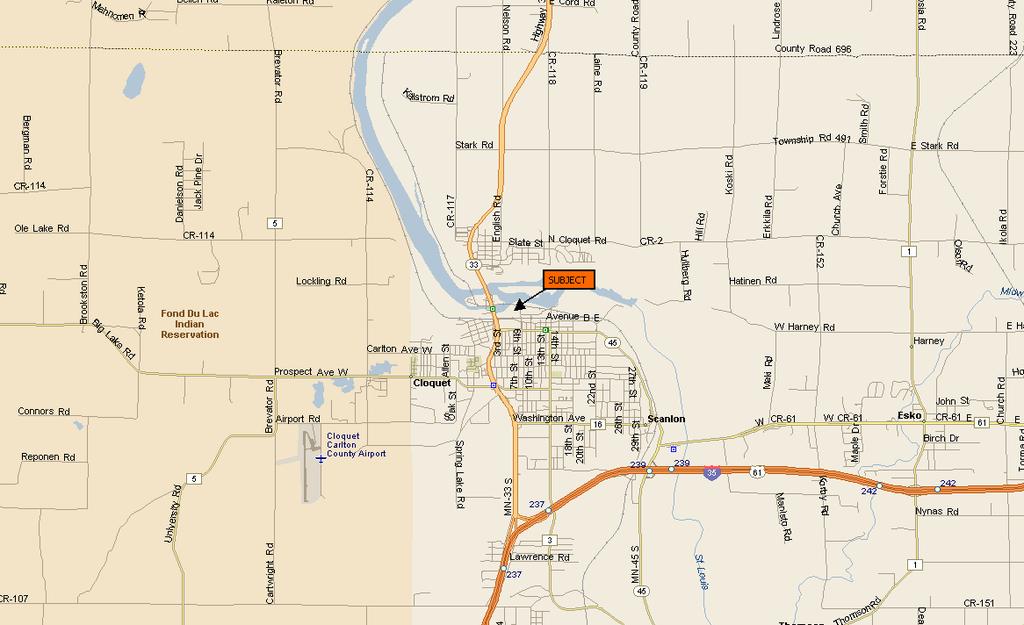
2 AREA MAP
3 LEGAL DESCRIPTION The property valued in this appraisal is depicted on the maps included with this report. The assessor parcel codes are and A survey should be obtained to confirm the site boundaries and legal description with easements and exceptions for roadways if any. TAX AND ASSESSMENT DATA Following are the estimated market values for the subject as determined by the Carlton County Assessor s office for taxes payable in Pay 2018 data is not available Parcel Code EMV Land EMV Building Total EMV Pay $26,000 $33,000 $59,000 $2, $54,100 $150,600 $204,700 $8,079 ZONING The subject property is located in the H-I Heavy Industrial zoning district. Allowable uses in this zoning district are quite varied and include manufacturing, commercial and industrial uses. My review of specific zoning regulations for this district reveals that the subject conforms to the necessary standards or has obtained the appropriate variances. The present use of the site as a distribution warehouse facility is a legally permissible use. FLOOD ZONE According to the FEMA Flood Zone Map # C, dated September 27, 1991, the subject is located within a minimal flood hazard area.

4 GIS MAP SUBJECT

5 ZONING MAP SUBJECT

6 SUBJECT FLOOD MAP
7 MARKET AREA DATA AND ANALYSIS City of Cloquet: The City of Cloquet is the largest city in Carlton County with a 2006 population estimate of 11,714, representing an increase over the 1990 census count of 10,885. Cloquet is situated 19 miles south of Duluth along Highway 33 near the intersection with Interstate 35 and is 142 miles from Minneapolis. Access to Cloquet is excellent from Duluth and the Twin Cities area via Interstate 35 and Highway 33. Highway 33 continues north to Highway 53 and the Iron Range. Highway 33 is heavily developed with commercial properties through the community of Cloquet. The commercial district has been expanding and properties constructed over the past ten years include several strip malls, Wendy s and Applebee s Restaurant as well as Super Walmart and Walgreens store. Major employers in Cloquet include the Fond Du Lac Indian reservation, Sappi Paper, USG Interiors, Cloquet Public Schools, Diamond Brands, Cloquet Community Hospital, Boldt Construction and Upper Lakes Foods. Cloquet s economic base is diversified over several market segments. Employment is conveniently available in Duluth as well. All municipal utilities are available in Cloquet including water, sewer, gas and electricity. Recreational opportunities include parks, Pine Valley ski area and sports fields. Cloquet has two elementary schools, one middle school, one high school and the Fond Du Lac community college. It was incorporated as a city in The City of Cloquet is a growing community with new and old housing stock, employment opportunities, and educational and recreational choices. Growth has been occurring in Cloquet in commercial development along Highway 33 and residential development has been occurring in new home developments.
8 NEIGHBORHOOD DATA Neighborhoods may be devoted to such likes as residential, commercial, industrial, agricultural, cultural and civic activities, or a mixture of these uses. An analysis of a neighborhood in which a particular property is located is important, due to the fact that the various physical, social, political and economic forces which affect that neighborhood also directly influence the individual properties within it. Neighborhood Overview: The subject property is located in the Cloquet industrial district two blocks north of the central business district and just south of the St. Louis River. The general character of the neighborhood reflects a diversity of uses. Examples include a large distribution warehouse, professional offices, industrial manufacturing and storage and retail sales. Neighborhood Boundaries: The neighborhood boundaries include Avenue B on the south, Highway 33 on the west, St. Louis River on the north and N 14 th Street on the east. Accessibility: Accessibility to the area and neighborhood is good. Highway 33, located a ¼ mile west, is a primary traffic artery connecting to Interstate 35 located 2.5 miles south and U.S. Highways 2 and 53 located 9 miles and 15 miles respectively north. Closer to the subject, Avenue B is the main east west thoroughfare is this area. The primary traffic artery extending through the subject s neighborhood is Industry Avenue. Two primary railroad spurs extend through the neighborhood with various spurs. The Duluth and Northeastern railroad track extends north of the subject and the Burlington Northern spur extends south. The subject s neighborhood has a very centralized location within the city of Cloquet and more importantly in the region which is ideal for a warehouse facility need access to primary roadways. Utilities: The neighborhood is serviced by city water, city storm and sanitary sewer, natural gas, electricity, phone and high-speed Internet access. Develop Stage: Neighborhoods are characterized as being in one of the four developmental stages. These stages are growth, stabilization, decline and rejuvenation. The subject s neighborhood is best described as being in the stabilization state. While some expansion and new development is occurring in the area it is not consistent enough to suggest a strong growth phase.

9 NEIGHBORHOOD MAP 15
10 SITE DESCRIPTION The subject parcel is located on the northwest corner of 8 th Street and Industry Avenue. Carlton County GIS maps depict the subject as an L shaped parcel. However, this is not correct. The parcel is rectangular shaped. Based on my review of the plat maps and aerial photos, it appears the land area comprises approximately 64,064 square feet excluding the roadways. A survey should be obtained to confirm the lot size. Improvements to the site include four warehouse and storage buildings, perimeter fencing and a gravel surface parking lot. Size and Dimensions: The approximate property line dimensions are as follows: North Property Line: 308 ± East Property Line: 208 South Property Line: 308 ± West Property Line: 208 The total site size calculates to 64,064 square feet according to my measurements. Topography - Vegetation: The topography of the site is generally level. Vegetation is limited to grass along the north edge of the site and minor landscaping and trees on the east side of the larger building. Utilities: Municipal water, gas and electric serve the site. Road Access: Access to the site is via N 8 th street or Industry Avenue Soil Conditions and Environmental Issues: I have not been provided with soil borings. However, soil conditions appear conducive to support the existing apartment structure. I have not been provided with a phase I or Phase II environmental assessment. The value conclusions of this report assume no detrimental impact to the presence of hazardous substances.
11 DESCRIPTION OF IMPROVEMENTS General Overview: Improvements to the site consist of four free standing buildings, gravel surface parking lot and perimeter fencing. The primary building comprises 6,480 square feet and is used as a distribution warehouse with a small segment dedicated to office space. The additional buildings include a 795 square foot storage building, 1,590 square foot service garage and 1,115 square foot equipment/vehicle storage building. Following is a more detailed description of the improvements. Distribution Warehouse Building: The building measures x 115 for a total area of 6,480 square feet. Used as a distribution warehouse, the building has a concrete foundation, steel frame with a metal exterior skin. There are six overhead doors two of which provide drive in access on the north side and four of which are elevated to standard loading dock heights on the west side. The interior has a concrete floor with the area servicing the west docks being elevated approximately 6 feet higher than the north end. A ramp connects the two levels. The entire building is heated; the warehouse area has suspended unit heaters. A small area dedicated to bathrooms, break room and offices is located on the south end of the building. The estimated effective age of this structure is 25 years with a remaining economic life of 20 years. The building exhibits were and tear consistent with its age. Building 4 Storage Building: This structure measures 32.8 x 34.4 and comprises approximately 795 square feet. The metal framed structure sits on wood posts and has a metal exterior skin. The building is used for storage and is unheated. Primary access is via sliding doors on the south elevation. The building exhibits deferred maintenance and needs repair work and paint. The effective age is estimated at 30 years with a remaining economic life of 15 years. Storage Building 5 Maintenance Garage The maintenance garage measures 32.2 x thus comprising 1,590 square feet. This structure has a concrete slab on grade, metal frame, and a metal exterior. Heat is provided by a suspended unit heater. Access is via a pedestrian door and an overhead garage door. The building exhibits deferred maintenance and needs some repair work and exterior paint. The estimate effective age is 30 years with a remaining economic life of 15 years. Kirsting Building This structure is utilized for vehicle storage and measures 26.4 x 42.2 thus comprising 1,115 square feet. The building has a concrete floor, steel frame and metal exterior covering. Heat is provided by suspended unit heater. The effective age of this structure is estimated at 10 years with a remaining economic life of 35 years. Miscellaneous site improvements: Additional site improvements include perimeter chain link fencing and gravel surface parking lot.

12 SUBJECT PHOTOGRAPHS KEMPS BUILDING SOUTH AND EAST ELEVATIONS NORTH ELEVATION


13 SUBJECT PHOTOGRAPHS WEST ELEVATION OFFICE INTERIOR


14 SUBJECT PHOTOGRAPHS LOADING DOCK AREA DRIVE IN DOCK AREA RAMP ON LEFT


15 SUBJECT PHOTOGRAPHS PRODUCT STORAGE AND TRANSFER AREA SERVICE GARAGE AND PRODUCT STORAGE BUILDING

16 SUBJECT PHOTOGRAPHS NEWER VEHICLE AND PRODUCT STORAGE BUILDING
FOR SALE Historic Frank Lloyd Wright Service Station Asking $380,000 Own A Piece of History
 FOR SALE Historic Frank Lloyd Wright Service Station Asking $380,000 Own A Piece of History Opened 1956 For Additional Information and To View the Property Please Contact Sandy Hoff - Office Phone 218-722-5556
Information Package E. Hillsborough Ave, Tampa, Florida 33610
 Information Package Bag mor: 74,117 Sqft Warehouse/Workshops plus 3,065 Sqft Office 5226 E. Hillsborough Ave, Tampa, Florida 33610 To schedule a tour or ask questions, please contact Logan Kearney at:
1084 Monet Dr 1084 Monet Dr, Baton Rouge, LA Nathan Foran Trek Realty th St,San Rafael, CA
 1084 Monet Dr 1084 Monet Dr, Baton Rouge, LA 70806 Nathan Foran Trek Realty 2100 4th St,San Rafael, CA 94901 Nathan@TrekRealty.com (415) 845-6283 1084 Monet Dr $1,095,000 1084 Monet Dr Baton Rouge is centrally
Prime Development Land
 SALE PRICE $17,000,000 ($7.84± psf) FEATURES Approximately 49.8 Acres of Industrial and Commercial Land for Sale Including a 45,200± SF Fully Leased Manufacturing Building 3 Zoning Classifications: Heavy
Address Southeast Quadrant of U.S. Highway 41 and Sumter Boulevard City. North Port State. FL Zip Code County
 SUBJECT AERIAL LOCATION LAND AREA THREE-YEAR OWNERSHIP HISTORY OF SUBJECT Address Southeast Quadrant of U.S. Highway 41 and Sumter Boulevard City North Port State FL Zip Code 34287 County Sarasota Nearest
Prime Development Land
 SALE PRICE $17,000,000 ($7.84± psf) FEATURES Approximately 49.8 Acres of Industrial and Commercial Land for Sale Including a 45,200± SF Fully Leased Manufacturing Building 3 Zoning Classifications: Heavy
SALE 48 RAGUS ROAD WOODSIDE BUSINESS PARK, DARTMOUTH, NS INDUSTRIAL/OFFICE FOR SALE 5,590 SF
 FOR SALE 48 RAGUS ROAD WOODSIDE BUSINESS PARK, DARTMOUTH, NS INDUSTRIAL/OFFICE FOR SALE 5,590 SF TOM GERARD, SIOR, CCIM Real Estate Advisor 902.830.1318 tomgerard@kwcommercial.com PHIL BOLHUIS Real Estate
1057 Canton RD Marietta, GA 30066
 1057 Canton RD Marietta, GA 30066 +/- 1.49 Acres Presently Zoned LI $350,000 With all utilities available. Very little lot prep necessary for most uses. Two Level steppes descending from the street level.
Waseca County Planning and Zoning Office
 Waseca County Planning and Zoning Office 300 North State Street Waseca, Minnesota 56093 Phone: 507-835-0650 Fax: 507-837-5310 Form no. PZ 081009 Web Site: www.co.waseca.mn.us FEES: 1) CUP FEE- $400.00
Direct Frontage on the Long Island Expressway!!
 Direct Frontage on the Long Island Expressway!! New Investment Opportunity - 100% Rented Single Tenant Asset Long Term Lease Offered for Sale for $7,500,000 New to market same Owner for 40+ years! Rented
600 W. St. Germain Street, St. Cloud, MN
 BANKRUPTCY SALE 99,300 Sq. Ft. Fee-Owned Big Box Retail Store Available 600 W. St. Germain Street, St. Cloud, MN Property Information Memorandum Michael Jerbich (312) 454-2057 michael@agrealtypartners.com
Property Information Package
 Property Information Package 1.641± Acres Zoned Commercial on Hwy 128 in Savannah, TN Selling in 2 Tracts (2) Aerial Map 1 Plat 2 Title Commitment 3 Traffic Info Station North of Property 6 Traffic Info
INDUSTRIAL BUILDING AND LOT
 INDUSTRIAL BUILDING AND LOT 9550-70 SOUTH GENOA AVENUE CHICAGO, IL 60643 David Makowski Senior Vice President 847.509.2757 davem@svn.com SVN AUCTIONWORKS 707 SKOKIE BLVD., SUITE 601, NORTHBROOK, IL 60062
DIVISION 2 - CONSTRUCTION PLAN AND MISCELLANEOUS REQUIREMENTS
 DIVISION 2 - CONSTRUCTION PLAN AND MISCELLANEOUS REQUIREMENTS 2.1 Required Plan Sheets 2.2 Drawing Requirements 2.3 Graphic Standards 2.4 Easements 2.5 Utility Locations 2.6 Private Facility Locations
PROPERTY OVERVIEW LOCATION OVERVIEW. For Information Contact: David Lasser, SIOR/CCIM
 EXECUTIVE SUMMARY OFFERING SUMMARY Sale Price: $1,050,000 Price / SF: $54.12 Building Size: 19,400 SF Lot Size: 2.14 Acres Zoning: B-3 Taxes: $23,200.68 PROPERTY OVERVIEW This is a 19,400 SF commercial
PINE CANYON PD ZONING REGULATIONS
 Review Notes: Green highlight = blanks to be completed before recording. 1. DEFINITIONS For purposes of the PD Plan and these Zoning Regulations: (1) capitalized terms used but not defined in the PD Plan
PLANNING AND ZONING COMMISSION VARIANCE
 PLANNING AND ZONING COMMISSION VARIANCE DOÑA ANA COUNTY COMMUNITY DEVELOPMENT DEPARTMENT Doña Ana County Government Center 845 N. Motel Blvd. Las Cruces, New Mexico 88007 Telephone: (575) 647-7350 MEETING
Diamond Falls Subdivision PROPOSED YELLOWSTONE COUNTY BOARD OF PLANNING FINDINGS OF FACT
 Diamond Falls Subdivision PROPOSED YELLOWSTONE COUNTY BOARD OF PLANNING FINDINGS OF FACT The City/County Planning Staff has prepared the Findings of Fact for the Diamond Falls Subdivision. These findings
FOR SALE OR LEASE 1960 N FEDERAL BLVD RIVERTON, WY COMMERCIAL PROPERTIES 550 N. POPLAR STREET CASPER, WY (307)
") COMMERCIAL PROPERTIES 550 N. POPLAR STREET CASPER, WY 82601 (307) 234-2385 1960 N FEDERAL BLVD RIVERTON, WY 82501 FOR SALE OR LEASE N FEDERAL BLVD N FEDERAL BLVD TABLE OF CONTENTS E WEBBWOOD RD SUBJECT
COMMERCIAL PROPERTIES 550 N. POPLAR STREET CASPER, WY 82601 (307) 234-2385 1960 N FEDERAL BLVD RIVERTON, WY 82501 FOR SALE OR LEASE N FEDERAL BLVD N FEDERAL BLVD TABLE OF CONTENTS E WEBBWOOD RD SUBJECT
1056 King Street. Charleston, SC Exclusive Sale Offering
 1056 King Street Property Summary The Offering Sale Price $800,000 / $23.63 per square foot MLS# 1030429 Parcel Size Approximately.78 Acres Building Size Approximately 33,850 Square Feet Property Name
BLACK RIVER FALLS INDUSTRIAL SITE
 WISCONSIN ECONOMIC DEVELOPMENT CORPORATION BLACK RIVER FALLS INDUSTRIAL SITE COMMUNITY OVERVIEW Black River Falls is located on the Black River in Jackson County, strategically located along I-94 between
COMMERCIAL DEVELOPMENT OPPORTUNITY US HIGHWAY 281 NORTH AT FM 1863 BULVERDE, TEXAS
 COMMERCIAL DEVELOPMENT OPPORTUNITY US HIGHWAY 281 NORTH AT FM 1863 BULVERDE, TEXAS LOCATION: The property is located on the west side of U.S. Highway 281, just west of the intersection of FM 1863. ZONING:
PC Staff Report 11/18/2013 Z Item No. 1-1
 Z-13-00401 Item No. 1-1 PLANNING COMMISSION REPORT Regular Agenda - Public Hearing Item PC Staff Report 11/18/2013 ITEM NO. 1: Z-13-00401 IG (General Industrial) District TO CS (Strip Commercial) District;
Fresno Multiple Listing Service
 Fresno Multiple Listing Service MLS Agent ID #: Address: *County: *APN #: Street #: Street Name: *City: Direction: Suffix: *Zip Code: *Cross Street: *Agent ID: *Office ID: Co-Agent ID: *Agent Name: *Office
LOOP 410 / HIGHWAY 151 AREA DEVELOPMENT PROPERTY
 LOOP 410 / HIGHWAY 151 AREA DEVELOPMENT PROPERTY LOCATION: SIZE: FRONTAGE: The tract is located at the southwest corner of Loop 410 and Lakeside Parkway in the southwest quadrant of Loop 410 / Highway
COUNCIL ACTION FORM. 1. The City Council can approve the Preliminary Plat for Menards Ames Subdivision
 ITEM #: 49 DATE: 03-27-18 COUNCIL ACTION FORM SUBJECT: PRELIMINARY PLAT FOR MENARDS BACKGROUND: Menards Ames Subdivision is a proposed 41-acre development on SE 16 th Street just west of the Skunk River.
FOR SALE OR LEASE. Manufacturing / Distribution Facility 85,262± Square Feet (Divisible) Acres
 Acres") FOR SALE OR LEASE Manufacturing / Distribution Facility 85,262± Square Feet (Divisible) 15.65 Acres 330 Southwell Boulevard Tifton, Tift County, Georgia 31794 SALES PRICE: $4,000,000 LEASE RATE: $2.00/PSF,
FOR SALE OR LEASE Manufacturing / Distribution Facility 85,262± Square Feet (Divisible) 15.65 Acres 330 Southwell Boulevard Tifton, Tift County, Georgia 31794 SALES PRICE: $4,000,000 LEASE RATE: $2.00/PSF,
SODO INDUSTRIAL BUILDING
 SODO INDUSTRIAL BUILDING 3628 E Marginal Way S Seattle, WA 98134 For more information contact: PROPERTY HIGHLIGHTS Well maintained warehouse & office space in the heart of Sodo Industrial District 1,734
APPLICATION SUBMITTAL REQUIREMENTS FOR Tentative Parcel or Subdivision Maps
 CITY OF EL CERRITO Community Development Department Planning and Building Division 10890 San Pablo Avenue, El Cerrito, CA 94530 (510) 215-4330 FA (510) 233-5401 planning@ci.el-cerrito.ca.us APPLICATION
9. REZONING NO Vicinity of the northwest corner of 143 rd Street and Metcalf Avenue
 9. REZONING NO. 2002-15 Vicinity of the northwest corner of 143 rd Street and Metcalf Avenue 1. APPLICANT: Andrew Schlagel is the applicant for this request. 2. REQUESTED ACTION: The applicant is requesting
Marketing Presentation 5550 Crowder Boulevard New Orleans, Louisiana 70127
 New Orleans, Louisiana 70127 69,348 SF Land For Sale at $285,000 Robert Hand, MBA, CCIM, SIOR Louisiana Commercial Realty 3900 North Causeway Boulevard-Suite 1200 New Orleans, Louisiana 504-289-8172 www.louisianacommercialrealty.com
For Sale 5701 Environment Drive Ft Pierce, FL 34981
 For Sale 5701 Environment Drive Ft Pierce, FL 34981 PROPERTY OVERVIEW Former citrus packing plant. Gross bldg improvements consisting of approximately 100,000sf comprised of 97,000sf+/- in main warehouse
WESTMINSTER PARK SUBDIVISION
 WESTMINSTER PARK SUBDIVISION Engineering Comments: FINAL PLAT COMMENTS (should be addressed prior to submitting the FINAL PLAT for review and/or signature by the City Engineer): A. Provide all of the required
105 Merchant Drive Montrose, Colorado 81401
 105 Merchant Drive 81401 COMMERCIAL LEASE INFORMATION PACKET John Renfrow * Joey Huskey Renfrow Realty Co-listed with Art Schwadron with Re/Max of Boulder, Inc, Jim Lucarelli with Real Estate Affiliates
Certified Site Program Application Trogdon Industrial Park
 Certified Site Program Application Trogdon Industrial Park Sabrina Drackert Economic Development Researcher Springfield Area Chamber of Commerce 202 S. John Q. Hammons Parkway Springfield, Missouri 65806
2381 CIRCUIT WAY INDUSTRIAL PROPERTY FOR SALE. Brooksville, FL Kari L. Grimaldi/ Broker
 INDUSTRIAL PROPERTY FOR SALE 2381 CIRCUIT WAY PRESENTED BY: FRANK GRIMALDI, SR. - (813) 245-1124 Grimaldi Commercial Realty Corp 115 W Bearss Ave Tampa, FL 33613 grimaldicommercialrealty.com PROPERTY OVERVIEW
THE APPRAISAL OF REAL ESTATE 2 CANADIAN EDITION BUSI 330 CHAPTER 9
 THE APPRAISAL OF REAL ESTATE ND 2 ANADIAN EDITION BUSI 330 REVIEW NOTES by HUK DUNN HAPTER 9 opyright 2004 by the Real Estate Division and huck Dunn. All rights reserved. Review Notes: Land or Site Analysis
For Sale. $2,850,000 Office/Warehouse/ Manufacturing th Avenue Baldwin, WI US HIGHWAYS 63 & 12
 836 Minnesota Street S. Bayport, MN 55003 Website: www.greystone-commercial.com Email: klacasse@greystone-commercial.com For Sale US HIGHWAYS 63 & 12 $2,850,000 Office/Warehouse/ Manufacturing Office/Warehouse/
ARTICLE 23 CONDOMINIUM STANDARDS
 ARTICLE 23 CONDOMINIUM STANDARDS Section 23.01 Intent. The intent of this Article is to provide regulatory standards for condominiums and site condominiums similar to those required for projects developed
Planned Residence District (PR) To review a plan to construct 11 single family homes on approximately 4.01 acres.
 To review a plan to construct 11 single family homes on approximately 4.01 acres.") STAFF REPORT PLANNING & ZONING COMMISSION Village Green Municipal Building, Council Chambers 47 Hall Street Wednesday, March 13, 2019 7:00 P.M. 1. FINAL DEVELOPMENT PLAN REVIEW Applicant: Romanelli and
STAFF REPORT PLANNING & ZONING COMMISSION Village Green Municipal Building, Council Chambers 47 Hall Street Wednesday, March 13, 2019 7:00 P.M. 1. FINAL DEVELOPMENT PLAN REVIEW Applicant: Romanelli and
72 Feick Avenue at I-78
 For Sale 72 Feick Avenue at I-78 Shartlesville, PA 19526 For more information, contact John Buccinno, SIOR, CCIM +1 610 370 8508 jbuccinno@ Steve Willems, SIOR +1 610 370 8506 swillems@ High Cube to 31
FOR SALE 2 INDUSTRIAL BUILDINGS
 FOR SALE 2 INDUSTRIAL BUILDINGS 10 ALDRICH AVE and/or 24 ALDRICH AVE. - NORWAY, ME 10 ALDRICH AVE 24 ALDRICH AVE RARE OPPORTUNITY IN OXFORD COUNTY 2 INDUSTRIAL BUILDINGS FOR SALE Can be sold separately
PLANNED UNIT DEVELOPMENT STAFF REPORT Date: October 19, 2017
 PLANNED UNIT DEVELOPMENT STAFF REPORT Date: October 19, 2017 DEVELOPMENT NAME LOCATION Custom Boat Storage 3975 Demetropolis Road (East side of Demetropolis Road, 0.2± miles South of Halls Mill Road.)
APPLICATION PROCEDURE
 ANTRIM PLANNING BOARD P. O. Box 517 Antrim, New Hampshire 03440 Phone: 603-588-6785 FAX: 603-588-2969 APPLICATION FORM AND CHECKLIST FOR MINOR OR MAJOR SITE PLAN REVIEW File Date Received By APPLICATION
City of Placerville Planning Commission STAFF REPORT
 Placerville, a Unique Historical Past Forging into a Golden Future City of Placerville STAFF REPORT SUBJECT: Consideration of a request to operate the automobile brokerage business in the Highway Commercial
PLANNING COMMISSION REPORT REGULAR AGENDA
 PP-4-4-11 Item No. 9-1 PLANNING COMMISSION REPORT REGULAR AGENDA PC Staff Report 06/22/11 ITEM NO 9: PRELIMINARY PLAT; KASOLD WATER TOWER ADDITION; SE OF TAM O SHANTER & KASOLD DR (MKM) PP-4-4-11: Consider
ORDINANCE NO. 208 BE IT ORDAINED BY THE CITY COUNCIL OF THE CITY OF UNIVERSITY HEIGHTS, JOHNSON COUNTY, IOWA:
 ORDINANCE NO. 208 AN ORDINANCE AMENDING ORDINANCE NO. 79 (ZONING) TO CREATE A COMMERCIAL HOTEL ZONE AND PERMIT DEVELOPMENT PURSUANT TO A COMMERCIAL HOTEL PUD BE IT ORDAINED BY THE CITY COUNCIL OF THE CITY
DEPARTMENT OF COMMUNITY DEVELOPMENT SERVICES. Planning Division. m e m o r a n d u m
 DEPARTMENT OF COMMUNITY DEVELOPMENT SERVICES Planning Division m e m o r a n d u m TO: FROM: The Urbana Zoning Board of Appeals Christopher Marx, AICP, Planner I DATE: December 15, 2017 SUBJECT: ZBA Case
Maryland Park Lake District
 Maryland Park Lake District A REGIONAL DEVELOPMENT OPPORTUNITY City of Maryland Heights Area Context 2,535 Acres northwest of MO RT 364 (Page Ave Extension) Protected by a 500-Year COE/FEMA-certified levee
AAAA. Planning and Zoning Staff Report Lake Shore Land Holdings, LLC CU-PH Analysis
 AAAA Planning and Zoning Staff Report Lake Shore Land Holdings, LLC CU-PH2016-28 Hearing Date: April 21, 2016 Development Services Department Applicant: BRS Architects/Cindy Huebert Staff: Kyle McCormick,
TAZA Matrix. Subject Property Address. Order Information. Subject Property Value. Broker s Opinion of Market Trend. Overview
 TAZA Matrix Main Contact Well Lane, San Diego, CA 92117 (626) 768-6000 success@tazacorp.com Subject Property Address 8305 Camino Del Oro, La Jolla, CA 92037 Order Information BPO Type Simple BPO Borrower
JORDAO PROPERTY ± RIPARIAN IRRIGATED CROPLAND. $2,438,000 ($23,000/Acre)
") JORDAO PROPERTY ±106.00 RIPARIAN IRRIGATED CROPLAND Located at: 7505 Hogin Road Crows Landing, Stanislaus County, CA 95313 APN s 057-026-009 & 057-026-008 Offered for $2,438,000 ($23,000/Acre) Presented
JORDAO PROPERTY ±106.00 RIPARIAN IRRIGATED CROPLAND Located at: 7505 Hogin Road Crows Landing, Stanislaus County, CA 95313 APN s 057-026-009 & 057-026-008 Offered for $2,438,000 ($23,000/Acre) Presented
NELSON ROAD INDUSTRIAL PORTFOLIO 7415 NELSON ROAD Fort Wayne, Indiana 46803
 FOR SALE OR LEASE INDUSTRIAL PORTFOLIO 7415 Fort Wayne, Indiana 46803 w w w.c b r e.us/for t wa y n e Part of the CBRE affiliate network FOR SALE OR LEASE INDUSTRIAL PORTFOLIO 7415 Fort Wayne, Indiana
Real Estate Offering Package Burnham Avenue, Unionville, CT FOR SALE or LEASE 18,500±SF Office / Warehouse Building on 1.88± acres 3.3.
 Real Estate Offering Package 34-38 Burnham Avenue, Unionville, CT 06085 FOR SALE or LEASE 18,500±SF Office / Warehouse Building on 1.88± acres 3.3. Table of Contents REDUCED SALE PRICE $675,000 LEASE RATE
SUBDIVISION DESIGN PRINCIPLES AND STANDARDS
 SECTION 15-200 SUBDIVISION DESIGN PRINCIPLES AND STANDARDS 15-201 STREET DESIGN PRINCIPLES 15-201.01 Streets shall generally conform to the collector and major street plan adopted by the Planning Commission
COMMERCIAL SITE DEVELOPMENT GUIDE FOR UNINCORPORATED ST. CHARLES COUNTY
 COMMERCIAL SITE DEVELOPMENT GUIDE FOR UNINCORPORATED ST. CHARLES COUNTY GENERAL INFORMATION: This brochure is to be used as a guide and is not intended to amend or supersede the corresponding County ordinances
A. Land Use Relationships
 Chapter 9 Land Use Plan A. Land Use Relationships Development patterns in Colleyville have evolved from basic agricultural and residential land uses, predominate during the early stages of Colleyville
-MENDOCINO COUNTY PLANNING AND BUILDING SERVICES- DIVISION OF LAND REGULATIONS TITLE 17
 ARTICLE VI -- GENERAL REGULATIONS AND PROVISIONS Sec. 17-50. Sec. 17-51 General Plan. Sec. 17-52 Lot and Block Design and Configuration. Sec. 17-53 Lot Access. Sec. 17-54 Private Roads. Sec. 17-55 Water
The following regulations shall apply in the R-E District:
 "R-E" RESIDENTIAL ESTATE DISTRICT (8/06) The following regulations shall apply in the R-E District: 1. Uses Permitted: The following uses are permitted. A Zoning Certificate may be required as provided
COMMUNITY DEVELOPMENT. Staff Report. Site Plan Review. SP June 19, 2018
 COMMUNITY DEVELOPMENT 333 Broadalbin Street SW, PO Box 490, Albany, Oregon 97321-0144 BUILDING 541-917-7553 PLANNING 541-917-7550 Staff Report Site Plan Review SP-18-18 June 19, 2018 Summary On May 1,
Certified Site Program Application Bolivar Business Park
 Certified Site Program Application Bolivar Business Park Sabrina Drackert Economic Development Researcher Springfield Area Chamber of Commerce 202 S. John Q. Hammons Parkway Springfield, Missouri 65806
FREESTANDING RETAIL/ INDUSTRIAL BUILDING
 FREESTANDING RETAIL/ INDUSTRIAL BUILDING 2901 SE GRAN PARK WAY STUART, FL 34997 Robert Hamman Senior Advisor 561.346.2310 robert.hamman@svn.com SVN FLORIDA COMMERCIAL REAL ESTATE ADVISORS 810 SATURN STREET,
Introduction. Background DEPARTMENT OF COMMUNITY DEVELOPMENT SERVICES. Planning Division. m e m o r a n d u m TO: The Urbana Zoning Board of Appeals
 DEPARTMENT OF COMMUNITY DEVELOPMENT SERVICES Planning Division m e m o r a n d u m TO: FROM: The Urbana Zoning Board of Appeals Christopher Marx, AICP, Planner I DATE: March 16, 218 SUBJECT: ZBA Case ZBA-218-C-2:
1 November 13, 2013 Public Hearing APPLICANT & PROPERTY OWNER: HOME ASSOCIATES OF VIRGINIA, INC.
 1 November 13, 2013 Public Hearing APPLICANT & PROPERTY OWNER: HOME ASSOCIATES OF VIRGINIA, INC. STAFF PLANNER: Carolyn A.K. Smith REQUEST: Conditional Change of Zoning (AG-1 & AG-2 Agricultural Districts
Draft Model Access Management Overlay Ordinance
 Draft Model Access Management Overlay Ordinance This model was developed using the City of Hutchinson and the Trunk Highway 7 corridor. The basic provisions of this model may be adopted by any jurisdiction
Burlington Unincorporated Community Plan
 Burlington Unincorporated Community Plan June 30, 2010 Meeting Page 1 of 24 Table of Contents (Page numbers to be inserted) I. Background a. Location and Community Description b. Planning of Unincorporated
PLANNED UNIT DEVELOPMENT & SUBDIVISION STAFF REPORT Date: November 17, 2016
 PLANNED UNIT DEVELOPMENT & SUBDIVISION STAFF REPORT Date: November 17, 2016 DEVELOPMENT NAME SUBDIVISION NAME LOCATION Autonation Ford of Mobile Autonation Ford of Mobile Subdivision 901, 909, and 925
3 NOVEMBER 9, 2011 Public Hearing APPLICANT:
 REQUEST: Conditional Change of Zoning (B-2 & I-1 to Conditional A-18) 3 NOVEMBER 9, 2011 Public Hearing APPLICANT: S.L. NUSBAUM REALTY COMPANY PROPERTY OWNER: USF PROPCO II, LLC STAFF PLANNER: Leslie Bonilla
Industrial 24,950 SF Palisado Avenue 1475 Palisado Avenue, Windsor, Connecticut 06095
 24,950 SF 1475 Palisado Avenue 1475 Palisado Avenue, Windsor, Connecticut 06095 Property Features Easy Highway Access 5 Dock Doors 600 Amp Service Additional Land Area Ample Parking Close to Hartford and
FREQUENTLY USED PLANNING & ZONING TERMS
 City Of Mustang FREQUENTLY USED PLANNING & ZONING TERMS Abut: Having property lines, street lines, or zoning district lines in common. Accessory Structure: A structure of secondary importance or function
IVY RIDGE - COMMERCIAL DEVELOPMENT PHASE II AUGUSTA COUNTY, VIRGINIA
 AUGUSTA COUNTY, VIRGINIA Page 1 Page 2 Offering Overview Commercial Sites in Fast Growing Area Immediate Area is now Hub of Medical Community Site is Ideal for Senior Care/Assisted Living Facility Recent
ARTICLE 3 DEFINITIONS
 Sections: 3-1 Rules of Construction 3-2 Definitions ARTICLE 3 DEFINITIONS SECTION 3-1 RULES OF CONSTRUCTION 3-101. a. The language set forth in these regulations shall be interpreted in accordance with
OCEAN INDUSTRIES BUSINESS PARK 11 Acadia Street, Dartmouth, Nova Scotia. Partnership. Performance.
 OCEAN INDUSTRIES BUSINESS PARK 11 Acadia Street, Dartmouth, Nova Scotia Partnership. Performance. WHY AVISON YOUNG? A Different Kind of Commercial Real Estate Company Avison Young is a global, full-service
For Sale 50 SOUTH QUEEN STREET MAYTOWN, PA Industrial/Commercial Realtors
 For Sale 717.293.4477 Industrial/Commercial Realtors 50 SOUTH QUEEN STREET MAYTOWN, PA 17550 1853 William Penn Way Lancaster, PA 17601 717.293.4477 www.highassociates.com For Sale 717.293.4477 Office/
24,000+ SF Commercial Property Available for Redevelopment in Superior, WI
 Redevelopment Opportunity 24,000+ SF Commercial Property Available for Redevelopment in Superior, WI Brisky Commercial Real Estate Serving Wisconsin & Minnesota Office: 612-413-4200 www.briskycommercial.com
APPENDIX C CHARACTERISTICS OF THE ENERGIZE PHOENIX CORRIDOR
 APPENDIX C CHARACTERISTICS OF THE ENERGIZE PHOENIX CORRIDOR BACKGROUND ON RESIDENTIAL AND COMMERCIAL BUILDINGS IN THE EP CORRIDOR The 10-mile EP corridor (Figure G1) is a highly diverse, mixed-use L-shaped
STAFF SUMMARY OF S18-04 SPECIAL USE PERMIT APPLICATION
 APPLICATION SUMMARY Case Number: S18-04 Request: STAFF SUMMARY OF S18-04 SPECIAL USE PERMIT APPLICATION Special use permit in order to develop an indoor/outdoor recreation facility Applicant: Property
EAGLES CREST II APARTMENT COMMUNITY FOR SALE INCLUDES MULTI FAMILY AND COMMERCIAL LAND 85 UNITS FOR SALE DAVENPORT, IOWA $6,200,000
 APARTMENT COMMUNITY FOR SALE INCLUDES MULTI FAMILY AND COMMERCIAL LAND 1 85 UNITS FOR SALE DAVENPORT, IOWA $6,200,000 EAGLES CREST II CHUCK RUHL, JR., SIOR President 563.355.4000 cruhl@ruhlcommercial.com
PRELIMINARY PLATS. The following documents are provided as required by the City of Conroe for use in the above titled platting submittals:
 Public Works Engineering Division CITY OF CONROE PRELIMINARY PLATS The following documents are provided as required by the City of Conroe for use in the above titled platting submittals: Submittal Questionnaire
A. Appropriate agency responsible for transportation review for the subject property.
 7.8.10 Procedure Any person desiring to create a minor subdivision shall submit to the Commission for approval an application on forms provided by the Division, and a record plat in conformance with the
714 BRADDOCK VIEW DRIVE LEMONT FURNACE, PA FOR LEASE INDUSTRIAL MARKETING FLYER
 714 BRADDOCK VIEW DRIVE LEMONT FURNACE, PA 15456 FOR LEASE INDUSTRIAL MARKETING FLYER PENN STATE FAYETTE THE EBERLY CAMPUS 714 BRADDOCK VIEW DRIVE YOUR NEW LOCATION GREATER UNIONTOWN BUSINESS PARK PARK
Tuesday, October 27, Hall Rd, Knoxville, TN Knox County, TN parcel#
 Property Report Tuesday, October 27, 2015 7905 Hall Rd, Knoxville, TN 37920 Knox County, TN parcel# 157 001 Property Report Location Property Address Subdivision County Current Owner Name Mailing Address
New Private Way Ordinance Westbrook Planning Board Workshop , Planning Board Public Hearing Definitions
 201 Definitions Private Right of Way; Private way A strip of land at least fifty feet wide, meeting the minimum standards for the construction of a gravel base for a public road, over which abutters may
860 Vandalia Street St. Paul, MN
 INDUSTRIAL PROPERTY FOR SALE 860 Vandalia Street St. Paul, MN Eric Batiza, Vice President DIRECT 952 837 3007 EMAIL eric.batiza@colliers.com Brian Doyle, Vice President DIRECT 952 837 3008 EMAIL brian.doyle@colliers.com
L. LAND USE. Page L-1
 L. LAND USE 1. Purpose This section discusses current and likely future land use patterns in Orland. An understanding of land use trends is very important in determining Orland's ability to absorb future
Chapter 9 Multiple Choice Questions
 Chapter 9 Multiple Choice Questions / Page 1 Chapter 9 Multiple Choice Questions 1. The text argues that students of real estate should study factors that influence demand at the national, regional, community
Zoning Variances. Overview of
 Overview of Zoning Variances City of Bishop Planning Department Purpose: Each zoning classification indicates specific development standards such as setbacks or parking requirements. There are occasions,
Major Impact Review for Solar Energy System, Large River Frontage Road, New Castle - Garfield County File Number MIPA
 March 23, 2016 Clean Energy Collective c/o Richard Miller 361 Centennial Parkway, Third Floor Louisville, CO 80027 Reference: Major Impact Review for Solar Energy System, Large 35960 River Frontage Road,
Frequently Asked Questions
 Frequently Asked Questions Q: What is The Ridge at Hangman? A: The Ridge at Hangman is a 930 acre Planned Unit Development residential community surrounding the Hangman Valley Golf Course that will contain
Contents Lists of Figures and Tables xi About the Author xiii Foreword xv Acknowledgments xvi Part I Introduction
 CHAPTER # Contents Lists of Figures and Tables... xi About the Author... xiii Foreword...xv Acknowledgments...xvi Part I Introduction... 1 1 Overview of Land Valuation Assignments and Adjustment Procedures...
16228 FLIGHT PATH DR. INDUSTRIAL PROPERTY FOR SALE. Brooksville, FL Kari L. Grimaldi/ Broker
 INDUSTRIAL PROPERTY FOR SALE PRESENTED BY FRANK GRIMALDI, SR. - (813) 245-1124 16228 FLIGHT PATH DR. Grimaldi Commercial Realty Corp 115 W Bearss Ave Tampa, FL 33613 grimaldicommercialrealty.com PROPERTY
PLANNED UNIT DEVELOPMENT, SIDEWALK WAIVER, & SUBDIVISION STAFF REPORT Date: November 6, 2008
 PLANNED UNIT DEVELOPMENT, SIDEWALK WAIVER, & SUBDIVISION STAFF REPORT Date: November 6, 2008 DEVELOPMENT NAME SUBDIVISION NAME LOCATION Frascati Shops, Inc. Frascati Subdivision 1120 Paper Mill Road CITY
COMMERCIAL PROPERTY FACT SHEET
 COMMERCIAL PROPERTY FACT SHEET 1615 Ritner Highway, Carlisle, PA 17013 Property Details: Building Type: Office & Warehouse List Price: $1,450,000 Building Size: 15,000 sq. ft. (10,800 SF is office / 4,200
ELK RAPIDS TOWNSHIP ANTRIM COUNTY, MICHIGAN ORDINANCE NO
 ELK RAPIDS TOWNSHIP ANTRIM COUNTY, MICHIGAN ORDINANCE NO. 3-2011 AN ORDINANCE TO REPLACE THE SUBDIVISION CONTROL ORDINANCE WITH A NEW SUBDIVISION DEVELOPMENT ORDINANCE, IN ACCORD WITH THE LAND DIVISION
Chapter 21 MOBILE HOME PARK REGULATIONS.
 Chapter 21 MOBILE HOME PARK REGULATIONS. Sec. 21.1 SCOPE. For the preservation of the interests of various types of residential developments which should be permitted in every community and for the protection
BRAND NEW WAREHOUSE BUILDINGS
 BRAND NEW WAREHOUSE BUILDINGS BUSINESS PARK DRIVE, PORT ST LUCIE FL 34952 3 WAREHOUSES SUMMER 2019 15,000-17,000 SF EXCLUSIVELY MARKETED BY BRAND NEW WAREHOUSE BUILDINGS Jeremiah Baron Broker Jeremiah
Concept Planned Unit Development Memorandum. Duke Realty is requesting Park 81 be considered for a Planned Unit Development
 Dtike 1550 Utica Avenue South Suite 420 Minneapolis, MN 55416 952.543.2900 To: From: Maple Grove City Planner Bill Shank Duke Realty Date: December 11, 2017 Subject: Concept Planned Unit Development Memorandum
SUBDIVISION, PLANNED UNIT DEVELOPMENT, ZONING AMENDMENT, & SIDEWALK WAIVER STAFF REPORT Date: July 19, 2018
 SUBDIVISION, PLANNED UNIT DEVELOPMENT, ZONING AMENDMENT, & SIDEWALK WAIVER STAFF REPORT Date: July 19, 2018 NAME SUBDIVISION NAME LOCATION West Mobile Properties, LLC U.S. Machine Subdivision 556, 566,
CONTACT US. SPECIAL PROPERTIES GROUP FOR SALE / FOR LEASE INDUSTRIAL BUILDING 913 N 17TH AVENUE Central City, NE 68826
 INDTRIAL BUILDING SPECIAL PROPERTIES GROUP FOR SALE BUILDING SIZE & SALE PRICE BUILDING SIZE: 158,135 SF TOTAL SALE PRICE: $2,200,000; $13.91 PSF LOT SIZE: 22.94 AC FOR LEASE AVAILABLE SPACE & LEASE RATE
Section Preliminary Plat Checklist and Application Forms
 Section 201 - Preliminary Plat Checklist and Application Forms PRELIMINARY SUBDIVISION PLAT REVIEW PROCESS CHART PRELIMINARY SUBDIVISION PLAT APPLICATION PRELIMINARY PLAT REVIEW CHECKLIST CITY OF NAMPA