Maryland Park Lake District
|
|
|
- Hector Porter
- 6 years ago
- Views:
Transcription


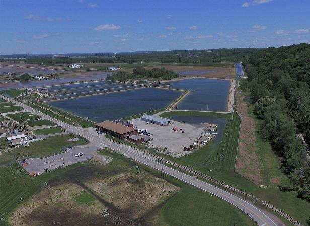
1 Maryland Park Lake District A REGIONAL DEVELOPMENT OPPORTUNITY City of Maryland Heights
2 Area Context 2,535 Acres northwest of MO RT 364 (Page Ave Extension) Protected by a 500-Year COE/FEMA-certified levee MO Route 141 (Maryland Heights Expressway) runs through the center Creve Coeur Park and Lake border to the southeast Riverport Business Park and Hollywood Casino border on the north Includes Creve Coeur Airport

3 Area Context

4 Area Context Earth City Business Park Hollywood Casino & Hotel Riverport Business Park St. Louis Lambert International Airport Hollywood Casino Amphitheater Creve Coeur Airport Creve Coeur Lake & Park
5 Why Promote Lake District Development? Represents a unique opportunity for the Region Ability to provide a mix of uses and experiences focused on hospitality and entertainment Capitalize on attractions already in place Widen the attraction of the area beyond the region Enhance and reinforce open space Focus on green, sustainable development patterns & techniques
6 Need for Public Financing Tools Some might say Why do we need more public investment? There s a 500-year certified levee, a $50 Million highway up the middle, nearby recreation amenities, an interstate spur highway on the southern border, lots of land Because: Lack of stormwater infrastructure No internal access roadway or utility infrastructure Infrastructure cost is greater than can be financed by the property owners and the City Real estate development can t absorb these costs and compete with other parts of the region
7 Need for Public Financing Tools Stormwater costs determined to date for the area are $30 million Costs not yet identified for needed stormwater control projects could easily add another $30 million Conservative and very preliminary cost estimates for roadway and non-stormwater utilities are $80 million This equals $140 million in costs before any land can be sold for development
8 Need for Public Financing Tools If 50% of the Area acreage can be developed after infrastructure is built and another 25 to 30% is devoted to zoning requirements (setbacks, easements, etc.), these costs could add $3.38 per square foot to development costs This figure would equal or exceed the asking price for development sites in the region without the added cost of the land The financing impediment is also related to the amount of infrastructure that would have to be constructed in order for development to start

9 The Earth City Example
10 The Earth City Example Initial area about 1,500 acres (about 2,700 with northern expansion (Corporate Woods) Expensive upfront costs (500-year levee, interchange w/ I-70, large internal stormwater drainage facilities, pumping stations, internal roadways and utilities) No public funds were made available Pace of development was strong but not enough to keep up with infrastructure financing costs
11 The Earth City Example Initial costs were driven up by inflation since legal challenges by environmental groups (ultimately overturned by the courts) stalled the project for more than 5 years A recession also slowed development Developer (Linclay) went bankrupt, but the project was saved by a deep-pocket financing entity (Ford Motor Credit) Build out took approximately 30 years Real estate experts at the time projected 20 years
12 The Earth City Example Had today s public financing tools been available the anticipated build out might have been realized and produced the economic benefit to the County and region earlier Today the current market value (per the St. Louis County Assessor) of Earth City and its later northern expansion is about $918 million According to the Census and ESRI, employment today is about 24,000
13 Why Promote Lake District Development? St. Louis County population has been declining According to the US Census: St. Louis County has the highest number of commuters coming from another county 236,344 workers live outside the County 139,222 County residents leave the County for work In 2011, 84.0 percent of workers in St. Louis County drove to work alone, compared with 76.4 percent nationally These commuting patterns fueled by regional sprawl contribute to the region s air quality and traffic issues
14 Why Promote Lake District Development? St. Louis County is largely built out The County and its municipalities have placed significant emphasis on revitalizing and redeveloping aging and obsolete areas of the built environment, but The areas where significant new development could occur are extremely limited by a variety of conditions: Unprotected floodplain areas Areas with significant topographic challenges Large areas of karst soil conditions unsuitable for development

15 Why Promote Lake District Development?
16 Public Financing Requirements Nearly all public financing tools that can assist the financing for the level of infrastructure needed require that certain conditions be present These are the blighted area criteria under various Missouri statutes Defective or Inadequate Street Layout; Insanitary and Unsafe Conditions; Improper Subdivision or Obsolete Platting; and Existence of Conditions Which Endanger Life or Property by Fire and Other Causes, or The existence of conditions which endanger life or property by fire and other causes, or any combination of such factors, retards the provision of housing accommodations or constitutes an economic or social liability or a menace to the public health, safety, morals, or welfare in its present condition and use

17 Lake District Qualifications Parcels Impacted by Lack of Access to Public Rights-of-Way

18 Lake District Qualifications Improper Subdivision or Obsolete Platting

19 Lake District Qualifications Flood Hazard

20 Lake District Qualifications Economic Underutilization and Liability Current area land uses represent economic underutilization
21 Lake District Qualifications Economic Underutilization and Liability 2017 EAV shows the value of the Area declined by 15.9% over 2016 values Assessments have declined every reassessment year after 2006 Comparison to other similar areas shows the extent to which the lack of development in the Lake District represents economic underutilization and an economic liability to all applicable taxing districts
22 Lake District Qualifications Economic Underutilization and Liability If we compare the Lake District using a measurement of EAV per acre and use Riverport and Earth City for comparison: The EAV of the Lake District in its present condition and uses is about $6,600 per acre The EAV of Riverport is about $149,000 per acre (19 times greater than the Lake District) The EAV of Earth City is about $104,000 per acre (16 times greater than the Lake District)
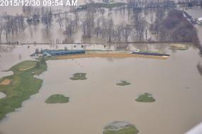
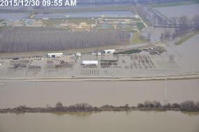
23 Lake District Qualifications Insanitary or Unsafe Conditions Lack of internal drainage creates flooding: Closes roadways impacting property access and causing public safety issues for drivers and for emergency vehicles Standing water breeds mosquitos Access to MSD treatment plant has been cut off Airport hangers and runways have flooded Farm and other industrial buildings have been flooded Property damage has resulted

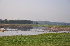


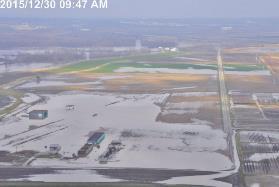
24 Lake District Qualifications Insanitary or Unsafe Conditions


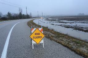
25 Lake District Qualifications Insanitary or Unsafe Conditions 2015

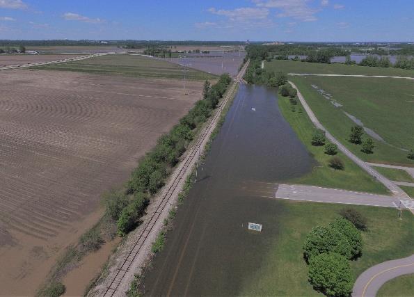
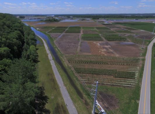
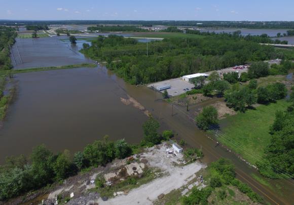

26 Lake District Qualifications Insanitary or Unsafe Conditions 2017
27 Summary In the finance and real estate market today (and for the predictable future), the Lake District will not develop without use of some public financing tools Even deep-pocket developers aren t taking on projects with this level of front end investment Making flood water an amenity is expensive Large floor plate and multi-story buildings on flood plain soils means higher building cost Green infrastructure and quality development drives up development costs
Downtown Meridian Urban Renewal Area URBAN RENEWAL ELIGIBILITY REPORT. Prepared for The City of Meridian and The Meridian Development Corporation
 Downtown Meridian Urban Renewal Area URBAN RENEWAL ELIGIBILITY REPORT Prepared for The City of Meridian and The Meridian Development Corporation by McKibben + Cooper Architects June 19, 2002 Authorization
CITY OF EAST PEORIA, ILLINOIS COSTCO AREA BUSINESS DISTRICT DEVELOPMENT AND REDEVELOPMENT PLAN
 CITY OF EAST PEORIA, ILLINOIS COSTCO AREA BUSINESS DISTRICT DEVELOPMENT AND REDEVELOPMENT PLAN I. INTRODUCTION The City of East Peoria (the City ) is located in Tazewell County, Illinois. In order to encourage
Village of Port Jefferson Urban Renewal Plan
 Urban Renewal Plan Village of Port Jefferson Urban Renewal Plan Port Jefferson, New York PREPARED FOR Village of Port Jefferson Village Board 121 West Broadway Port Jefferson, NY 11777 631.473.4724 PREPARED
TAX INCREMENT FINANCING PLAN PARAGON STAR, LLC
 TAX INCREMENT FINANCING PLAN PARAGON STAR, LLC JANUARY 6, 2016 FEBRUARY 17, 2016 1 TABLE OF CONTENTS I. DEFINITIONS 4 II. TAX INCREMENT FINANCING 6 III. GENERAL DESCRIPTION OF REDEVELOPMENT PLAN AND PROJECT
TAX INCREMENT FINANCING REDEVELOPMENT PLAN & PROJECT
 TAX INCREMENT FINANCING REDEVELOPMENT PLAN & PROJECT... SOUTHWEST CORRIDORS REDEVELOPMENT PROJECT AREA. Prepared for: City of Collinsville, Illinois March 25, 2016 ST. LOUIS, MISSOURI TIF Redevelopment
H 7291 S T A T E O F R H O D E I S L A N D
 LC000 01 -- H 1 S T A T E O F R H O D E I S L A N D IN GENERAL ASSEMBLY JANUARY SESSION, A.D. 01 A N A C T RELATING TO TOWNS AND CITIES -- REDEVELOPMENT AGENCIES AND PROJECTS Introduced By: Representatives
URBAN REVITALIZATION PLAN CITY OF DECORAH, IOWA 2014 DECORAH HOUSING URBAN REVITALIZATION AREA ADOPTED NOVEMBER 3, 2014
 URBAN REVITALIZATION PLAN CITY OF DECORAH, IOWA 2014 DECORAH HOUSING URBAN REVITALIZATION AREA ADOPTED NOVEMBER 3, 2014 Public Hearing held September 2, 2014 Second Public Hearing held October 6, 2014
APPLICATION REVIEW CHECKLISTS
 APPLICATION REVIEW CHECKLISTS The following must be submitted with and are part of each application. No application is complete until all required documentation has been submitted to the Community Development
FOR SALE 605 Industry Ave DISTRIBUTION WAREHOUSE FACILITY Asking $395,000
 FOR SALE 605 Industry Ave DISTRIBUTION WAREHOUSE FACILITY Asking $395,000 For Additional Information and To View the Property Please Contact Sandy Hoff - Office Phone 218-722-5556 shoff@fisalter.com AREA
a. It is the intent of these regulations to encourage the preservation of natural resources and facilitate orderly growth in the County.
 Part V Transfer of Development Rights Section 246. 1. Intent a. It is the intent of these regulations to encourage the preservation of natural resources and facilitate orderly growth in the County. b.
Diamond Falls Subdivision PROPOSED YELLOWSTONE COUNTY BOARD OF PLANNING FINDINGS OF FACT
 Diamond Falls Subdivision PROPOSED YELLOWSTONE COUNTY BOARD OF PLANNING FINDINGS OF FACT The City/County Planning Staff has prepared the Findings of Fact for the Diamond Falls Subdivision. These findings
Staff Report: Date: Applicant: Property Identification: Acreage of Request: Current Zoning of Requested Area: Requested Action: Attached:
 Staff Report: Completed by Jeff Palmer Director of Planning & Zoning Date: November 7, 2018, Updated November 20, 2018 Applicant: Greg Smith, Oberer Land Developer agent for Ronald Montgomery ET AL Property
Delta Urban Renewal Authority Blight Study
 Delta Urban Renewal Authority Blight Study February 2017 1 Table of Contents 1. Introduction.3 1.1 Purpose..3 1.2 Colorado Urban Renewal Law..3 1.3 Study Methodology..5 2. Study Area Analysis.6 2.1 Study..6
Summary. Draft Redevelopment Plan Summary Flowery Branch Tax Allocation District # 1:
 Summary Draft Redevelopment Plan Summary Flowery Branch Tax Allocation District # 1: Flowery Branch Tax Allocation District Old Town and Commercial Gateways 1 Public Hearing Presentation November 21, 2007
Residential Minor Subdivision Review Checklist
 Residential Minor Subdivision Review Checklist Plan Submittal Requirements: 2 full sets of stamped plans Electric submittal - all plans contained in a single PDF 3 full sets if commercial kitchen or dining
Residential Major Subdivision Review Checklist
 Residential Major Subdivision Review Checklist Plan Submittal Requirements: 2 full sets of stamped plans Electric submittal - all plans contained in a single PDF 3 full sets if commercial kitchen or dining
Investment Opportunity Rupley Site
 Investment Opportunity Rupley Site Site size 5.28 acres Location Northwest corner of exit 48 off of South Huntington Access I-5 freeway, street access directly from South Huntington (on truck route), BNSF
Scattered Sites Redevelopment Plan
 Scattered Sites Redevelopment Plan Township of Woodbridge Middlesex County, New Jersey Prepared by: Township of Woodbridge Department of Planning & Development January 2017 Amended September 2018 ENDORSED
PLANNED UNIT DEVELOPMENTS (Ordinance No.: 3036, 12/3/07; Repealed & Replaced by Ordinance No.: 4166, 10/15/12)
") 159.62 PLANNED UNIT DEVELOPMENTS (Ordinance No.: 3036, 12/3/07; Repealed & Replaced by Ordinance No.: 4166, 10/15/12) A. PURPOSE 1. General. The Planned Unit Development (PUD) approach provides the flexibility
159.62 PLANNED UNIT DEVELOPMENTS (Ordinance No.: 3036, 12/3/07; Repealed & Replaced by Ordinance No.: 4166, 10/15/12) A. PURPOSE 1. General. The Planned Unit Development (PUD) approach provides the flexibility
Section Intent
 Section 246. 1. Intent 2. Authority a. It is the intent of these Transfer of Development Rights (TDR s) regulations to encourage the preservation of natural resources and facilitate orderly growth in the
Section 4 Master Plan Framework
 Section 4 Master Plan Framework 4.1 PURPOSE The Master Plan, as an implementation tool of the SPC District, establishes the primary framework for the overall development of the Property. Detailed site
PLANNING COMMISSION REPORT REGULAR AGENDA
 PP-4-4-11 Item No. 9-1 PLANNING COMMISSION REPORT REGULAR AGENDA PC Staff Report 06/22/11 ITEM NO 9: PRELIMINARY PLAT; KASOLD WATER TOWER ADDITION; SE OF TAM O SHANTER & KASOLD DR (MKM) PP-4-4-11: Consider
REZONING GUIDE. Zone Map Amendment (Rezoning) - Application. Rezoning Application Page 1 of 3. Return completed form to
 - Application. Rezoning Application Page 1 of 3. Return completed form to") COMMUNITY PLANNING & DEVELOPMENT REZONING GUIDE Rezoning Application Page 1 of 3 Zone Map Amendment (Rezoning) - Application PROPERTY OWNER INFORMATION* PROPERTY OWNER(S) REPRESENTATIVE** CHECK IF POINT
COMMUNITY PLANNING & DEVELOPMENT REZONING GUIDE Rezoning Application Page 1 of 3 Zone Map Amendment (Rezoning) - Application PROPERTY OWNER INFORMATION* PROPERTY OWNER(S) REPRESENTATIVE** CHECK IF POINT
Suburban Sprawl: Exposing Hidden Costs, Identifying Innovations. Summary
 : Exposing Hidden Costs, Identifying Innovations Summary October 2013 Suburban sprawl is spreading across Canada as cities expand outwards to accommodate the growing demand for lower cost houses. But it
Staff Report: Date: Applicant: Property Identification: Acreage of Request: Current Zoning of Requested Area: Requested Action: Attached:
 Staff Report: Completed by Jeff Palmer Director of Planning & Zoning Date: November 7, 2018 Applicant: Greg Smith, Oberer Land Developer agent for Ronald Montgomery ET AL Property Identification: Frontage
BLACK RIVER FALLS INDUSTRIAL SITE
 WISCONSIN ECONOMIC DEVELOPMENT CORPORATION BLACK RIVER FALLS INDUSTRIAL SITE COMMUNITY OVERVIEW Black River Falls is located on the Black River in Jackson County, strategically located along I-94 between
Pueblo Regional Development Plan, Addendum
 Pueblo Regional Development Plan, Addendum August 2014 Table of Contents Factual Foundation.1 Land Demand Analysis....1 Population Trends 2 Housing Trends..3 Employment Trends 4 Future Land Demand Summary.5
Attachment 4. Planning Commission Staff Report. June 26, 2017
 Planning Commission Staff Report June 26, 2017 Agenda #: Regular Agenda - 2 Title: Applicant: Request: Location: Existing Zoning: Proposed Use: Staff Planner: The Brands and The Brands West Eagle Crossing
2014 Plan of Conservation and Development. Development Plan & Policies
 The Town of Hebron Section 3 2014 Plan of Conservation and Development Development Plan & Policies C. Residential Districts I. Residential Land Analysis This section of the plan uses the land use and vacant
Waseca County Planning and Zoning Office
 Waseca County Planning and Zoning Office 300 North State Street Waseca, Minnesota 56093 Phone: 507-835-0650 Fax: 507-837-5310 Form no. PZ 081009 Web Site: www.co.waseca.mn.us FEES: 1) CUP FEE- $400.00
MAJOR BOUNDARY LINE ADJUSTMENT PROCESS GUIDE
 MAJOR BOUNDARY LINE ADJUSTMENT PROCESS GUIDE Clear Creek County Planning Department P.O. Box 2000 Georgetown, Colorado 80444 (303) 679-2436 - phone (303) 569-1103 - fax PURPOSE To establish criteria and
TABLE OF CONTENTS. I. Introduction II. Statutory Basis for Business District III. Blight Analysis... 7
 AI RPORT BUSI NESSDI STRI CT REDEVELOPMENT PLAN&PROJECT Febr uar y12,2018 TheVi l l ageof BETHALTO,I L TABLE OF CONTENTS SECTION PAGE I. Introduction... 2 II. Statutory Basis for Business District... 3
MINOR BOUNDARY LINE ADJUSTMENT PROCESS GUIDE
 MINOR BOUNDARY LINE ADJUSTMENT PROCESS GUIDE Clear Creek County Planning Department P.O. Box 2000 Georgetown, Colorado 80444 (303) 679-2436 phone (303) 569-1103 fax 1 PURPOSE To establish criteria and
Understanding Texas TIRZ Statute Chapter 311 Texas Tax Code
 CDFA/TEDC TIRZ SEMINAR Understanding Texas TIRZ Statute Chapter 311 Texas Tax Code Clark Stockton Lord Constitutional Authority The legislature by general law may authorize an incorporated city or town
RICHFIELD WAY REDEVELOPMENT PLAN
 VILLAGE OF MENOMONEE FALLS, WISCONSIN RICHFIELD WAY REDEVELOPMENT PLAN Prepared by: Village of Menomonee Falls, Wisconsin Community Development Authority Approved by the Community Development Authority
Blight and Substandard Study City of Blair, Nebraska
 Blight and Substandard Study City of Blair, Nebraska 2014 JEO Consulting Group, Inc. Project No. 131365.00 Adopted, 2014 Resolution No. Introduction Introduction Purpose of the Study This Blair Blight
Presence-Saint Joseph Medical Center Area Redevelopment Project Area
 CITY OF JOLIET, IL Presence-Saint Joseph Medical Center Area Redevelopment Project Area Tax Increment Financing Eligibility Study and Redevelopment Plan and Project November 2, 2016 CITY OF JOLIET, IL
Study Area Description Study Area Context Existing Land Use and Zoning Districts
 TABLE OF CONTENTS Table of Contents SECTION I: INTRODUCTION Definition of Blight Study Methodology Report Format SECTION II: AREA OVERVIEW AND DESCRIPTION Study Area Description Study Area Context Existing
ARTICLE 23 CONDOMINIUM STANDARDS
 ARTICLE 23 CONDOMINIUM STANDARDS Section 23.01 Intent. The intent of this Article is to provide regulatory standards for condominiums and site condominiums similar to those required for projects developed
City of Lawrence Neighborhood Revitalization Plan and Program: 1101/1115 Indiana Street Lawrence, KS
 City of Lawrence Neighborhood Revitalization Plan and Program: 1101/1115 Indiana Street Lawrence, KS Definition: Area - used interchangeably with Property, referring to the property located at 1101/1115
JORDAO PROPERTY ± RIPARIAN IRRIGATED CROPLAND. $2,438,000 ($23,000/Acre)
") JORDAO PROPERTY ±106.00 RIPARIAN IRRIGATED CROPLAND Located at: 7505 Hogin Road Crows Landing, Stanislaus County, CA 95313 APN s 057-026-009 & 057-026-008 Offered for $2,438,000 ($23,000/Acre) Presented
JORDAO PROPERTY ±106.00 RIPARIAN IRRIGATED CROPLAND Located at: 7505 Hogin Road Crows Landing, Stanislaus County, CA 95313 APN s 057-026-009 & 057-026-008 Offered for $2,438,000 ($23,000/Acre) Presented
TASK 2 INITIAL REVIEW AND ANALYSIS U.S. 301/GALL BOULEVARD CORRIDOR FORM-BASED CODE
 TASK 2 INITIAL REVIEW AND ANALYSIS U.S. 301/GALL BOULEVARD CORRIDOR FORM-BASED CODE INTRODUCTION Using the framework established by the U.S. 301/Gall Boulevard Corridor Regulating Plan (Regulating Plan),
BELL COUNTY INFRASTRUCTURE REQUIREMENTS FOR MANUFACTURED HOME RENTAL COMMUNITIES
 BELL COUNTY INFRASTRUCTURE REQUIREMENTS FOR MANUFACTURED HOME RENTAL COMMUNITIES 1. Definitions: a. Manufactured Home-Means a structure falling within the definition of manufactured housing in Art. 5221f,
Comprehensive Plan 2030
 Introduction The purpose of this chapter of the Comprehensive Plan is to accurately describe, in words and images, the goals and visions for the future of Clearfield, as determined by the people who live
Redevelopment Project Plan and Eligibility Report for the: Cook County Project Area. Village of East Dundee, Illinois. Draft: July 18, 2012
 for the: Cook County Project Area Village of East Dundee, Illinois Draft: Created By: Vandewalle & Associates 2012 Table of Contents TABLE OF CONTENTS Table of Contents... i Executive Summary... 1 Part
Chapter 100 Planned Unit Development in Corvallis Urban Fringe
 100.100 Scope and Purpose. Chapter 100 Planned Unit Development in Corvallis Urban Fringe (1) All applications for land divisions in the Urban Residential (UR) and Flood Plain Agriculture (FPA) zones within
PREPARED BY TREASURE COAST REGIONAL PLANNING COUNCIL
 PREPARED BY TREASURE COAST REGIONAL PLANNING COUNCIL OCTOBER 12, 2017 What is a Community Redevelopment Agency? Definition of a CRA: A dependent special district in which any future increases in property
Burlington Unincorporated Community Plan
 Burlington Unincorporated Community Plan June 30, 2010 Meeting Page 1 of 24 Table of Contents (Page numbers to be inserted) I. Background a. Location and Community Description b. Planning of Unincorporated
9. REZONING NO Vicinity of the northwest corner of 143 rd Street and Metcalf Avenue
 9. REZONING NO. 2002-15 Vicinity of the northwest corner of 143 rd Street and Metcalf Avenue 1. APPLICANT: Andrew Schlagel is the applicant for this request. 2. REQUESTED ACTION: The applicant is requesting
ZONING AMENDMENT, PLANNED UNIT DEVELOPMENT & SUBDIVISION STAFF REPORT Date: March 5, 2009
 ZONING AMENDMENT, PLANNED UNIT DEVELOPMENT & SUBDIVISION STAFF REPORT Date: March 5, 2009 NAME SUBDIVISION NAME LOCATION Kentress Morrisette Booker T. Washington Highlands Subdivision, First Addition,
Review of Land Divisions in Open Space and Residential Zones 660
 Title 33, Planning and Zoning Chapter 33.660 5/24/18 Review of Land Divisions in Open Space and Residential Zones 33.660 Review of Land Divisions in Open Space and Residential Zones 660 Sections: General
Legal Description Part of the Western Half of the Eastern Half of the Northwest Quarter of Section 30, Le Ray Township
 Owner and Applicant s 20448 State Highway 83 Mankato, MN 56001 Request and Location Request for review and approval of a Conditional Use Permit to allow an Elder Care Residential Unit to be constructed
Note: Staff reports can be accessed at
 The Maryland-National Capital Park and Planning Commission Prince George's County Planning Department Development Review Division 301-952-3530 Note: Staff reports can be accessed at www.mncppc.org/pgco/planning/plan.htm.
******************************************************************************
 AN ORDINANCE OF THE CITY COUNCIL OF THE CITY OF BAYTOWN, TEXAS, EXCLUDING LAND FROM REINVESTMENT ZONE NO. ONE, CITY OF BAYTOWN, TEXAS; INCLUDING LAND WITHIN THE ZONE; EXTENDING THE TERM OF SUCH ZONE; APPROVING
Chapter 22 PLANNED UNIT DEVELOPMENT.
 Chapter 22 PLANNED UNIT DEVELOPMENT. Sec. 22.1 INTENT. The use of land and the construction and use of buildings and other structures as Planned Unit Developments in Georgetown Township may be established
PLANNED UNIT DEVELOPMENT & SUBDIVISION STAFF REPORT Date: September 15, 2016
 # 10 SUB2016-00089 PLANNED UNIT DEVELOPMENT & SUBDIVISION STAFF REPORT Date: September 15, 2016 NAME SUBDIVISION NAME LOCATION Lot 12 Laughlin Industrial Park Subdivision Lot 12 Laughlin Industrial Park
REPORT TO PLANNING & ZONING COMMISSION - CITY OF MARYLAND HEIGHTS
 REPORT TO PLANNING & ZONING COMMISSION - CITY OF MARYLAND HEIGHTS APPLICATION NUMBER APPLICATION (PROJECT) NAME APPLICANT NAME PROPERTY OWNER CUP16-0008 HSL SPORTS SPORTPORT HSL Sports, LLC c/o Greensfelder,
Existing Conditions: Economic Market Assessment
 Existing Conditions: Economic Market Assessment Introduction The US 24/40 Corridor Study examined existing conditions as they related to economic and commercial market assessments, existing land use, and
REZONING GUIDE. Zone Map Amendment (Rezoning) - Application. Rezoning Application Page 1 of 3. Return completed form to
 - Application. Rezoning Application Page 1 of 3. Return completed form to") Zone Map Amendment (Rezoning) - Application COMMUNITY PLANNING & DEVELOPMENT REZONING GUIDE Rezoning Application Page 1 of 3 PROPERTY OWNER INFORMATION* CHECK IF POINT OF CONTACT FOR APPLICATION Property
Zone Map Amendment (Rezoning) - Application COMMUNITY PLANNING & DEVELOPMENT REZONING GUIDE Rezoning Application Page 1 of 3 PROPERTY OWNER INFORMATION* CHECK IF POINT OF CONTACT FOR APPLICATION Property
THE SUBDIVISION AND LAND DEVELOPMENT REVIEW PROCESS
 THE SUBDIVISION AND LAND DEVELOPMENT REVIEW PROCESS INTRODUCTION: Howard County Subdivision and Land Development Regulations are intended to promote the health, safety and general welfare of County residents.
Arch-Laclede s Landing Station
 Arch-Laclede s Landing Station This station profile describes existing conditions around the Arch-Laclede s Landing MetroLink Station. This is one of a set of profiles for each of the MetroLink System
Accepting Development Proposals
 Accepting Development Proposals Background The Economic Development Corporation (EDC) of the is currently accepting proposals from firms with an interest in redeveloping the vacant parcel of property located
POPULATION FORECASTS
 POPULATION FORECASTS Between 2015 and 2045, the total population is projected to increase by 373,125 residents to reach 2.2 million. Some areas will see major increases, while other areas will see very
ORDINANCE WHEREAS, the adoption of this Ordinance shall not be construed as an admission that the aforesaid claim has merit or is correct; and
 ORDINANCE 12-24 AN ORDINANCE OF THE CITY OF WINTER GARDEN, FLORIDA, REPEALING ORDINANCE 12-02 AND REPLACING IT WITH THE AMENDMENTS TO ARTICLE V OF CHAPTER 118 OF THE WINTER GARDEN CODE OF ORDINANCES CONTAINED
WEST BEND CORPORATE CENTER
 WISCONSIN ECONOMIC DEVELOPMENT CORPORATION WEST BEND CORPORATE CENTER COMMUNITY OVERVIEW The City of West Bend is located in Washington County, the heart of the Kettle Moraine in Southeastern Wisconsin.
A. Land Use Relationships
 Chapter 9 Land Use Plan A. Land Use Relationships Development patterns in Colleyville have evolved from basic agricultural and residential land uses, predominate during the early stages of Colleyville
REPORT TO PLANNING & ZONING COMMISSION - CITY OF MARYLAND HEIGHTS
 APPLICATION NUMBER APPLICATION (PROJECT) NAME APPLICANT NAME PROPERTY OWNER NAME CUP16-0003 CENTRAL POWER SYSTEMS & SERVICES, INC. Central Power Systems & Services, Inc. 900 Liberty Drive, Liberty, MO
ESTES VALLEY STORMWATER MANAGEMENT PROGRAM
 ESTES VALLEY STORMWATER MANAGEMENT PROGRAM Phase I. Stormwater Master Plan Phase II. Stormwater Utility Feasibility Study Board of Realtors Meeting May 3, 2018 Stormwater Master Plan Summary Stormwater
ARTICLE V PRELIMINARY PLAN SUBMISSION
 ARTICLE V PRELIMINARY PLAN SUBMISSION 501. Plan Requirements a. On or before the 25 th day of the month prior to a regularly scheduled meeting of the Planning Commission, the applicant shall submit two
EXHIBIT D. Planned Unit Development Written Description April 13, 2016 Rouen Cove Phase II PUD
 1 EXHIBIT D Planned Unit Development Written Description April 13, 2016 Rouen Cove Phase II PUD Development # 8986.001 Developer: Curtis L. Hart Hart Resources LLC 8051 Tara Lane Jacksonville, Florida
Staff Report PLANNING DIVISION COMMUNITY & ECONOMIC DEVELOPMENT. Alley Closure
 Staff Report PLANNING DIVISION COMMUNITY & ECONOMIC DEVELOPMENT To: From: Salt Lake City Planning Commission Doug Dansie, 801-535-6182, doug.dansie@slcgov.com Date: March 23, 2016 Re: PLNPCM2015-00941
Special Use Permit - Planned Unit Development Checklist. Property Address:
 Special Use Permit - Planned Unit Development Checklist Special Use Permit Number. Parcel Code/s #28-11- - - Property Address: Applicant: ARTICLE VIII Ordinance Reference - Section 8.1.2 Permit Procedures:
PLANNING COMMISSION REPORT Regular Agenda - Public Hearing Item
 Z-15-00469 Item No. 6A- 1 PLANNING COMMISSION REPORT Regular Agenda - Public Hearing Item PC Staff Report 11/16/15 ITEM NO. 6A GPI, RM12, & RS40 TO RM12; 14.756 ACRES; 5200 & 5300 CLINTON PKWY (SLD) Z-15-00469:
3.1 PZ / 20 W. Northwest Highway / Nicholas & Associates / Plat of subdivision and conditional use for a final planned unit development
 Agenda Item Details Meeting Category Subject Access Type Feb 22, 2018 - MOUNT PROSPECT PLANNING AND ZONING COMMISSION 3. NEW BUSINESS 3.1 PZ-01-18 / 20 W. Northwest Highway / Nicholas & Associates / Plat
. Excellent location near Kansas Speedway/Village
 FOR SALE 220 Acres Master Planned Multifamily and Commercial Near Kansas Speedway Kansas Highway 7 126th Street SITE State Avenue The Plaza at Village West Legends Outlets Community America Ballpark Sporting
Certified Site Program Application Bolivar Business Park
 Certified Site Program Application Bolivar Business Park Sabrina Drackert Economic Development Researcher Springfield Area Chamber of Commerce 202 S. John Q. Hammons Parkway Springfield, Missouri 65806
DOUGLAS COUNTY ZONING RESOLUTION Section 4 LRR - Large Rural Residential District 3/10/99. -Section Contents-
 SECTION 4 LRR LARGE RURAL RESIDENTIAL DISTRICT -Section Contents- 401 Intent... 4-2 402 Principal Uses... 4-2 403 Accessory Uses... 4-3 404 Uses Permitted by Special Review... 4-4 405 Land Dedication...
Existing Land Use. Typical densities for single-family detached residential development in Cumberland County: 1
 Existing Land Use A description of existing land use in Cumberland County is fundamental to understanding the character of the County and its development related issues. Economic factors, development trends,
Letter of Intent May 2017 (Revised November 2017)
") THE BEACH AT WOODMOOR LETTER OF INTENT MAY 2017 (REVISED NOVEMBER 2017) OWNER/APPLICANT: CONSULTANT: Lake Woodmoor Holdings LLC N.E.S. Inc. 1755 Telstar Drive, Suite 211 619 North Cascade Avenue Colorado
THE BEACH AT WOODMOOR LETTER OF INTENT MAY 2017 (REVISED NOVEMBER 2017) OWNER/APPLICANT: CONSULTANT: Lake Woodmoor Holdings LLC N.E.S. Inc. 1755 Telstar Drive, Suite 211 619 North Cascade Avenue Colorado
FOR SALE 140 N. BRENTWOOD CLAYTON, MO FOR SALE DOWNTOWN CLAYTON OPPORTUNITY LAND AVAILABLE FOR REDEVELOPMENT
 FOR SALE 140 N. BRENTWOOD CLAYTON, MO FOR SALE DOWNTOWN CLAYTON OPPORTUNITY LAND AVAILABLE FOR REDEVELOPMENT TABLE OF CONTENTS Section1 Section 2 Section 3 Section 4 Offering Summary Development Opportunity
Reading Plats and the Complexities of Antiquated Subdivisions Presented by: David W. Depew, PhD, AICP, LEED AP Morris-Depew Associates, Inc.
 Presented by: David W. Depew, PhD, AICP, LEED AP Morris-Depew Associates, Inc. Introduction Plat is a term for a survey of a piece of land to identify boundaries, easements, flood zones, roadway, and access
HOUSING ELEMENT Inventory Analysis
 HOUSING ELEMENT Inventory Analysis 2.100 INVENTORY Age of Housing Stock Table 2.25 shows when Plantation's housing stock was constructed. The latest available data with this kind of breakdown is 2010.
TOOELE COUNTY LAND USE ORDINANCE CHAPTER 31 Page 1
 CHAPTER 31 PLANNED COMMUNITY ZONE (P-C) Section 31-1 Definitions. 31-2 Purpose. 31-3 Land use districts. 31-4 P-C zone area minimum requirements. 31-5 Permitted uses. 31-6 Conditional uses. 31-7 Planning
A PRELIMINARY FINANCIAL AND ECONOMIC REDEVELOPMENT FEASIBILITY STUDY FOR THE CITY OF FERNLEY, NEVADA
 TECHNICAL REPORT UCED 2015/16-07 A PRELIMINARY FINANCIAL AND ECONOMIC REDEVELOPMENT FEASIBILITY STUDY FOR THE CITY OF FERNLEY, NEVADA UNIVERSITY OF NEVADA, RENO A PRELIMINARY FINANCIAL AND ECONOMIC REDEVELOPMENT
BROWNFIELDS MARKETABILITY SCORING TOOL
 BROWNFIELDS MARKETABILITY SCORING TOOL Prioritize brownfield sites for redevelopment using this scoring tool that takes into account the following site and community characteristics: 1 2 3 4 5 6 7 8 9
Comprehensive Plan /24/01
 IV The is a central component of the Comprehensive Plan. It is an extension of the general goals and policies of the community, as well as a reflection of previous development decisions and the physical
To achieve growth, property development, redevelopment and an improved tax base in the cities and boroughs in the Lehigh Valley.
 Most growth in property valuation is in townships. Between 1991 and 2004, the assessed valuation of the townships in the Lehigh Valley increased by more than $2.8 billion, an increase of 41%. At the same
SECTION 10 STANDARD PLATS
 SECTION 10 - STANDARD PLATS Subdivision 1: Purpose Standard Plats allow the subdivision of land into lots smaller than the minimum metes and bounds size in the zoning district, and control road development
Town of Lisbon, Maine SUBDIVISION REVIEW APPLICATION
 Date Received: Fee Paid (amount): Applicant: Town of Lisbon, Maine SUBDIVISION REVIEW APPLICATION Subdivision Name/Title: This application must be received at the Town Office by close of business on the
Historic Mercy Hospital Area
 Historic Mercy Hospital Area Constructed 1919 1615 8 th Street South 1 A Significant Historic and Cultural Icon The community worked for ten years to raise funds to construct a modern hospital in a time
REGIONAL. Rental Housing in San Joaquin County
 Lodi 12 EBERHARDT SCHOOL OF BUSINESS Business Forecasting Center in partnership with San Joaquin Council of Governments 99 26 5 205 Tracy 4 Lathrop Stockton 120 Manteca Ripon Escalon REGIONAL analyst april
to St. Louis County by deed recorded in Book 7954, Page 235 in the St. Louis County, Missouri
 Recommendation of Planning Commission BILL NO. 4032 ORDINANCE NO. 2015-3971 AN ORDINANCE ENACTING A CONDITIONAL USE PERMIT FOR AN ELECTRICAL SUBSTATION AT 11520 DORSETT ROAD Petition of Ameren Missouri)
Certified Site Program Application Trogdon Industrial Park
 Certified Site Program Application Trogdon Industrial Park Sabrina Drackert Economic Development Researcher Springfield Area Chamber of Commerce 202 S. John Q. Hammons Parkway Springfield, Missouri 65806
APPENDIX D: DEFINITIONS
 D APPENDIX D: DEFINITIONS Terms used throughout the 2040 Comprehensive Plan should be interpreted using the definitions provided in this appendix. For interpretation of any term not defined, defer to the
Kyle Eichhorn, PE, PS Project Manager
 Kyle Eichhorn, PE, PS Project Manager PROFESSIONAL EXPERIENCE Kyle is a Project Manager for the Schneider Corporation s office located in Indianapolis, Indiana. Kyle has 9 years of diversified engineering
RESEARCH BRIEF. Oct. 31, 2012 Volume 2, Issue 3
 RESEARCH BRIEF Oct. 31, 2012 Volume 2, Issue 3 PDR programs affect landowners conversion decision in Maryland PDR programs pay farmers to give up their right to convert their farmland to residential and
Technology Park Planned Unit Development Technology Park PUD-IP
 Technology Park Planned Unit Development Technology Park PUD-IP Rob Anderson Community Development Director Planned Unit Development Background 2 Planned Unit Development (PUD) means a mixed use redevelopment
REPORT TO THE SHELBY COUNTY PLANNING COMMISSION From the Department of Development Services Planning Services. February 4, 2019
 REPORT TO THE SHELBY COUNTY PLANNING COMMISSION From the Department of Development Services Planning Services February 4, 2019 Case No. Request for Rezoning Approval From E-1 to E-2 SD This is a request
PLANNING COMMISSION REPORT Regular Agenda Public Hearing Item
 CUP-15-00474 Item No. 5-1 PC Staff Report 11/16/15 ITEM NO. 5 PLANNING COMMISSION REPORT Regular Agenda Public Hearing Item CONDITIONAL USE PERMIT FOR PUBLIC WHOLESALE WATER SUPPLY DISTRICT NO. 25; E 1300
Follow the Numbers: Why We Oppose the Inclusion of the Illiana Expressway in GO TO 2040 August 30, 2013
 Follow the Numbers: Why We Oppose the Inclusion of the Illiana Expressway in GO TO 2040 August 30, 2013 The Illinois Dept. of Transportation (IDOT) has requested that the Chicago Metropolitan Agency for