PINE CANYON PD ZONING REGULATIONS
|
|
|
- June Charles
- 5 years ago
- Views:
Transcription
1 Review Notes: Green highlight = blanks to be completed before recording. 1. DEFINITIONS For purposes of the PD Plan and these Zoning Regulations: (1) capitalized terms used but not defined in the PD Plan or theses Zoning Regulations but defined in the Castle rock Municipal Code, as amended (the Code ) shall have the meanings ascribed to them in the Code, (2) if capitalized terms are used in the PD Plan or these Zoning Regulations that are defined in the Code and either the PD Plan or theses Zoning Regulations, then the definitions contained in the PD Plan or these Zoning Regulations, as appropriate, shall control, and (3) capitalized terms defined in the PD Plan or these Zoning Regulations but not defined in the Code shall have the meanings ascribed to them in the PD Plan or the Zoning Regulations, as appropriate. Accessory Unit means a one-bedroom Dwelling Unit that: (1) contains no more than 1,500 square feet of interior floor area, (2) is located on the same lot as a principal Dwelling Unit that is a single-family detached dwelling, (3) contains both kitchen and bathroom facilities as part such one-bedroom Dwelling Unit that are separate and distinct from the Kitchen and bathroom facilities intended to serve the principal Dwelling Unit to which such on-bedroom Dwelling Unit is accessory, and (4) is located on a lot the Site Development Plan of which expressly states that an Accessory Unit may be located on such lot. An Accessory Unit may be held out for lease or rent, but may not be conveyed separately from the Principal dwelling to which it is accessory. For purposes of this definition of Accessory Units, the term interior floor area means the interior finished floor area on any story contained within the perimeter walls, windows and doors, as measured to the interior surface of such walls, windows and doors, but does not include upper level openings for stairs or other features, balconies or garages. Character Zone means any of the designations C1, C2, C3, C4, C5, C6 and SCZ-A, which are assigned to various portions of the Property pursuant to the terms of these Zoning Regulations, and which establish permitted uses, allowable densities and other development standards and regulations for those portions of the Property assigned thereto. Code means Town of Castle Rock Municipal Code. Development Agreement means the Pine Canyon Development between the Town and the Owners, dated and Recorded on at Reception No.. Director means the Town s Director of Development Services. Dwelling Unit means a building or portion thereof within the Property intended to be used predominantly for residential occupancy, including single-family, two-family, multi-family dwelling units, Accessory Units and the portion of a Live-Work Unit intended to be used predominantly for residential occupancy, but not including mobile homes, hotels, motels, hospitals, dormitories, assisted living facilities, nursing homes, or motor homes. Page 1
2 Excluded Parcel means: (1) land assigned to character Zone C1 and (2) any land offered for dedication to the Town for purposes of constructing and operating a school, or other civic facility (including without limitation, a fire station, police station, Town administrative offices or water treatment facility) thereon. Plat means a plat, including all amendments thereto, approved by the Town and Recorded. Lead Owner means JRW Family Limited Partnership, a Colorado limited liability limited partnership, and its successors and assigns, but only to the extent: (1) such successors and assigns are so designated by the then-lead Owner by separate written instrument that specifically and expressly designates such successor or assign by reference to the PD Documents and this definition of Lead Owner, and (2) such instrument is executed on behalf of the then-lead Owner and Recorded. Official Records means the official real property records of the Clerk and Recorder for Douglas County, Colorado. POST Plan means the Parks, Open Space and Trails Plan contained within the PD Plan. Owner means each of (1) JRW Family Limited Partnership, a Colorado limited liability limited partnership, (2) James R. Walker, (3) Michelle A. Walker, (4) Kurt J. Walker,(5) Brittany M. Walker, and (6) Lisa A. Walker to the extent of their respective interests in the Property, together with their respective successors and assigned with respect to such interests. PD Documents means the PD Plan, these Zoning Regulations and the Development Agreement. PD Plan means The Pine Canyon Planned Development Plan No. 1 recorded at reception no.. Planning Areas means the 21 planning areas depicted generally on the PD Plan as O1 through O13, PLD-1, and D1 through D7, the boundaries of which may be adjusted as set forth in Section 7. Property means the parcels of land described in Appendix A of these zoning regulations. Record, Recorded or Recording means record, recorded or recording, as appropriate, in the Official Records. Retail Restriction Zone means the retail restriction zone the boundaries of which are depicted generally on the PD Plan. SCZ-A means special Character Zone SCZ-A, the boundaries of which are depicted generally on the PD Plan. Page 2
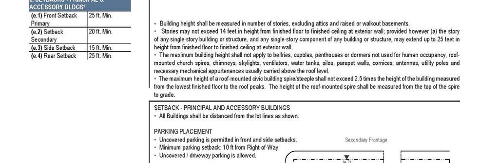
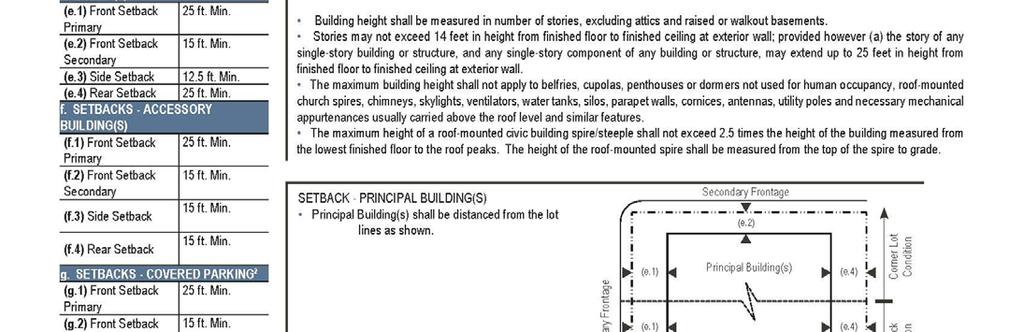
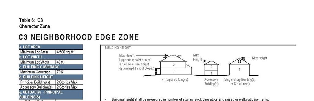
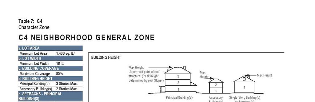
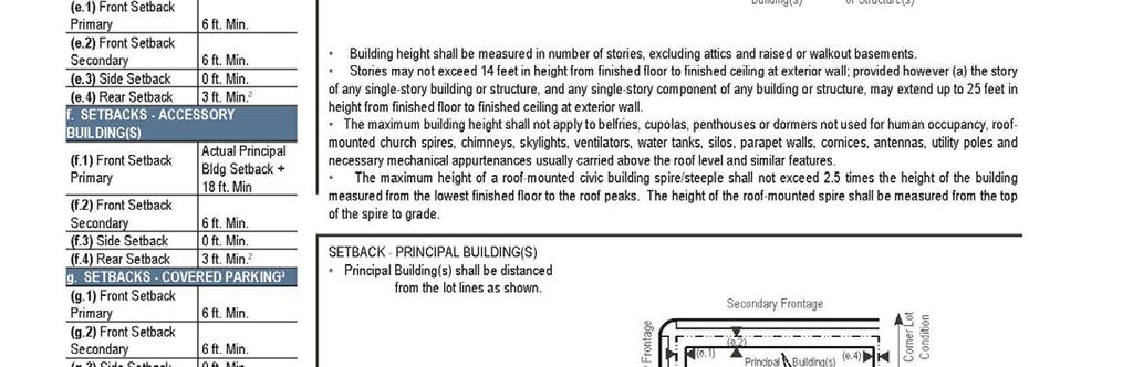
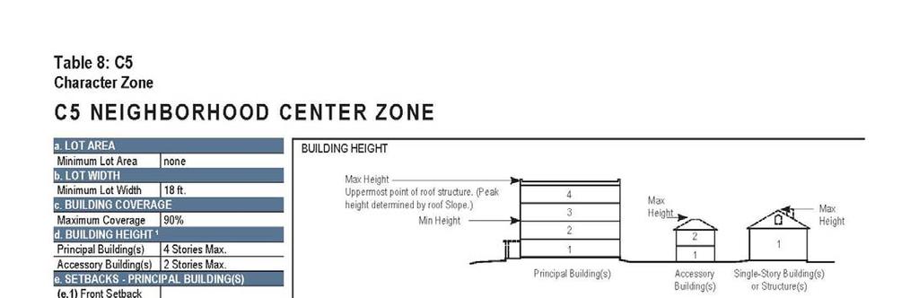
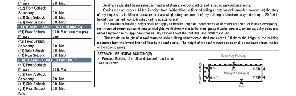
3 Thoroughfare means a street, roadway, passage, drive, lane or similar area intended primarily for vehicular traffic. Town means the Town of Castle Rock, Colorado. Trails means those trails the alignments of which are depicted generally on the PD Plan. Trail Standards means those standards set forth in Exhibit Aas well as the standards described in the Town of Castle Rock Sustainable Trail Development Guide. Unallocated Density means Dwelling Unit density permitted within the Property pursuant to PD Documents that is not yet constructed. Zoning Regulations has the meaning given to that term in these Pine Canyon PD Zoning Regulations and the regulations found in Town of Castle Rock Municipal Code Title GENERAL PROVISIONS A. Applicability. The Pine Canyon PD Plan, as amended (the PD Plan ) and The Pine Canyon Zoning Regulations (the Zoning Regulations ) shall run with the land and bind owners or record and successors in interest to the property. B. Relationship to Town Regulations. All Town ordinances and regulations, as the same are amended from time to time, shall apply to and be enforceable in a PD. Accordingly, the Town ordinances and regulations shall govern and control over any conflicting provisions in these Zoning Regulations unless such conflicting provision is vested as an express development right under the Development Agreement, any subsequent development agreement with the Town, or otherwise. C. Overall Project Standards. The standard zoning requirements of the Town zoning ordinance, including off-street parking, landscaping, site development, accessory and temporary uses, and use by special review and variance processes, shall apply to those areas within the Property. The PD Zoning Regulations shall not preclude the application of Town ordinances, including revisions to Title 17 of the Code, which are of general application throughout the Town, unless such application would conflict with an express vested property right in the Development Agreement, any subsequent development agreement with the Town, or otherwise. D. Illustrations in Tables. The metrics and text set forth in Tables 1 through 10 are an integral part of these Zoning Regulations. However, the diagrams and illustrations that accompany such Tables are provided for information purposes only and are not regulatory, with the exception of the diagrams and illustrations set forth in Tables 4 through 10 regarding building heights, minimum lot width, maximum building coverage, setbacks and covered parking placement, which are binding. To the extent of any conflict between any text (including a metric contained in text) and a diagram or illustration (including a metric shown on a diagram or illustration), the text shall control. Page 3
4 E. References. Unless otherwise specified, any reference in these Zoning Regulations to a Section or Table shall mean a section of, or table within, these Zoning Regulations. F. Lead Owner. Notwithstanding any other provision in the PD Documents, the rights of Lead Owner expressly set forth in the PD Documents shall not run with the land, but shall be held personally by Lead Owner (and its successors and assigns consistent with the conditions set forth in the definition of Lead Owner in Section 1). 3. MAXIMUM LEVEL OF DEVELOPMENT Subject to the provisions of the PD Documents, each of: (A) the maximum number of Dwelling Units permitted within each Planning Area, (B) the gross acreage within each Planning Area, (C) the percent of total gross acreage within each Planning Area, and (D) the maximum non-residential square footage or FAR permitted within each Planning Area is set forth in Table 1 below. [The remainder of this page is intentionally left blank. The Zoning Regulations continue on the following page.] Page 4
5 Planning Area Maximum Number of Dwelling Units 1 Table 1 Gross Acreage 2 Percent of Total Gross Acreage 3 OS % OS % OS % OS % OS % OS % OS % OS % OS % OS % OS % OS % OS % PLD % D % D % D % D % D % D % D % Maximum Nonresidential square footage or FAR 4 See footnote 4 School Site 0 Included in PLD-1 -- Major Roadways % Total % 1 The maximum number of Dwelling Units set forth in Table 1 may be adjusted pursuant to Section 8 (regarding density transfers). 2 The gross acreage within any Planning Area set forth in Table 1 may be adjusted pursuant to Section 7 (regarding changes in Planning Area boundaries). 3 The percent of total gross acreage within any Planning Area set forth in Table 1 may be adjusted pursuant to Section 7 (regarding changes in Planning Area boundaries.). 4 The maximum amount of non-residential square footage or FAR permitted within each Planning Area shall be determined by the uses permitted within each Planning Area, physical constraints and the parking requirements set forth in these Zoning Regulations. Page 5
6 4. CHARACTER ZONES A. Assignment of Character Zones. (i) (ii) Site Development Plan or Plat. Within each Site Development Plan or Plat containing any portion of the Property, the Owner Recording such Site Development Plan or Plat shall assign a Character Zone to each portion of the Property included within such Site Development Plan or Plat, subject to the conditions of this Section 4. Percentage Parameters. (a) Character Zones C2 through C6 shall be permitted only within certain Planning Areas as set forth in Table 2 below. Assignments for Character Zones C2 through C6 shall not be inconsistent with the percentage parameters set forth therefor on Table 2 below. Such percentage parameters shall be applied to the entirety of any given Planning Area (except Excluded Parcels), not with respect to a Plat that includes only a portion of such Planning Area; provided, however, Character Zones within any Plat may not be assigned such that it is impossible for the percentage parameters for the relevant Planning Area to be Maintained once the entirety of such Planning Area is included within Plats. (b) Character Zone C1 shall be permitted within any of Planning Areas D1 through D7, in any amount. (c) For purposes of calculating the percentage parameters within Table 2 below, the Percentage in respect of any Character Zone within any Planning Area shall mean the product of: (i) 100% multiplied by (ii) a fraction, the numerator of which is the total number of acres within such Character Zone other than Excluded Parcels that are assigned to such Character Zone, and the denominator of which is the total number of acres within such Planning Area other than Excluded Parcels. (iii) Amendments to Character Zone Assignments. (a) Character Zone assignments shall be deemed amended if set forth on a Recorded amendment to a Plat or Site Development Plan, on the condition that: (1) the Owner of the property whose Character Zone assignment is amended signs the amended document, (2) such reassigned Character Zones designations comply with this Section 4 and (3) each sketch, Site Development Plan and plat application submitted to the Town in respect thereof, the Recorded Site Development Plan, or Plat amendment therefor, and the Character Zone reassignments thereon, are each expressly approved by Lead Owner by signing the relevant documents. Page 6
7 (b) Notwithstanding Section 4(A)(iii)(a), if improvements have been constructed on any portion of the Property, the Character Zone assignment for such portion of the Property may not be amended if doing so would result in such improvements not conforming to the development standards set forth in Tables 4 through 10. B. Maximum Gross Residential Density. (i) (ii) The residential density within any of Character Zones C2 through C6 as measured within a single Planning Area (e.g., D1) shall not exceed the amount set forth therefor on Table 2 below. The maximum Gross Residential Density within any Character Zone set forth a Site Development Plan or Plat shall not exceed the amount set forth therefor on Table 2 below. [The remainder of this page is intentionally left blank. The Zoning Regulations continue on the following page.] Page 7
8 Table 2 Planning Area Acreage 1 D D D D4 5.0 D D D Permitted Character Zones and Percentages 2 C % C % C2 0-50% C % C % C5 0-40% C2 0-50% C % C % C5 0-40% C6 0-40% C % C % C % C % C4 0-50% C % C % C % C % Maximum Residential Gross Density (du/ac) N/A N/A Maximum Number of Dwelling Units The gross acreage within any Planning Area set forth in Table 2 may be adjusted pursuant to Section 7 (regarding changes in Planning Area boundaries). 2 The Character Zones permitted within Planning Areas D1 through D7 and the interpretation of the permitted percentage parameters for Character Zones set forth in Table 2 are each subject to the provisions of Section 4. 3 Residential Gross Density, with respect to any Character Zone, means the amount equal to a fraction, the numerator of which is the total number of Dwelling Units within such Character Zone, and the denominator of which is the total number of acres, including without limitation thoroughfares, parks and open space, within such Character Zone. 4 The maximum number of Dwelling Units permitted within any of Planning Areas D1 through D7 set forth in Table 2 may be adjusted pursuant to Section 8 (regarding density transfers). 5 Hotel rooms or Single Family Dwelling Units. Page 8
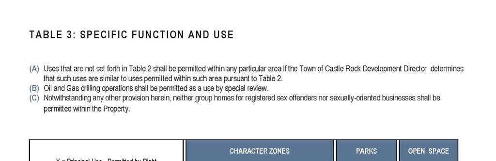
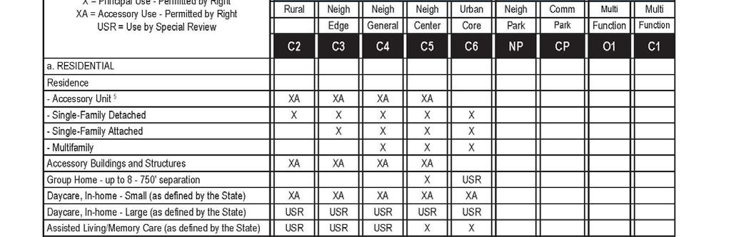
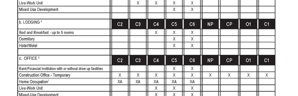
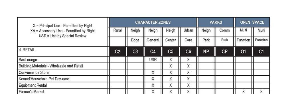
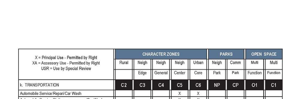
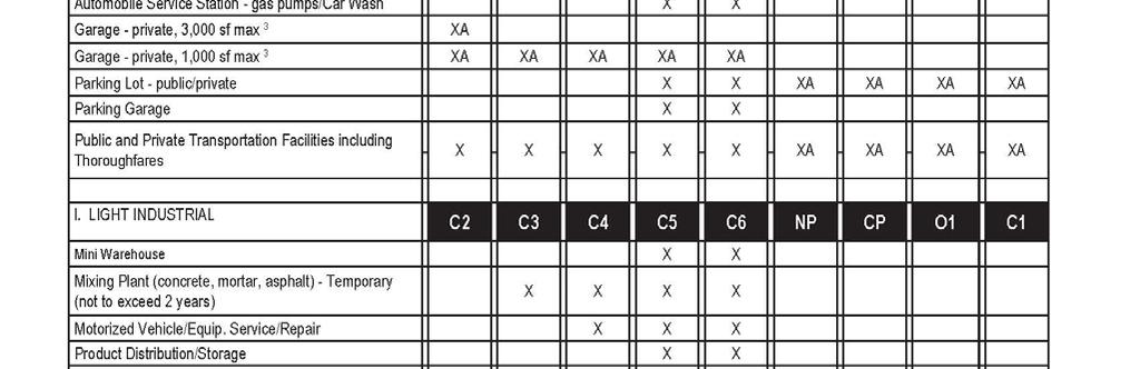
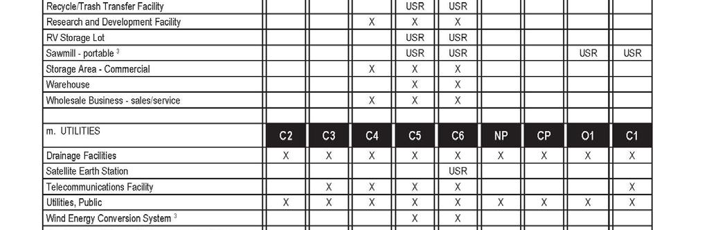
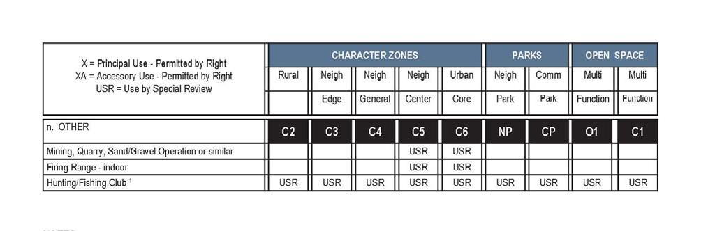
9 5. PERMITTED USES. Principal uses permitted by right, accessory uses permitted by right, principal uses permitted by special review, and accessory uses permitted by special review for each Character Zone, and for O-1 Planning Areas (OS-1 through OS-13 and PLD-1) are set forth on Table 3. In addition to those accessory uses set forth in Table 3, additional uses, buildings and structures that are accessory to a principal uses shall be permitted on the same lot as the principal use to which they are accessory. [The remainder of this page is intentionally left blank. The Zoning Regulations continue on the following page.] Page 9
10 Page 10
11 Page 11
12 Page 12
13 Page 13
14 Page 14
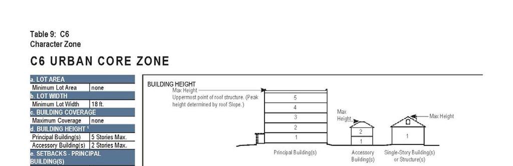
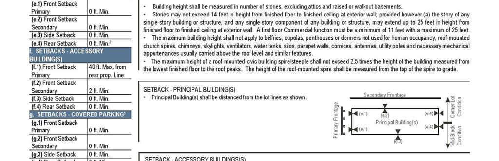
15 6. DEVELOPMENT STANDARDS. A. Trails. All Trails designated as Major Trails on the POST Plan shall be eight feet wide, with a concrete surface or other surface acceptable to Owner and the Director, and otherwise shall conform to the requirements for Type I trails as set forth in the Trail Standards. All Trails designated as Minor Trails on the POST Plan shall be between two and four feet wide, with a native surface, and otherwise conform to the requirements for Type II trails set forth in the Trail Standard. B. Road Standards and Off-Street Parking. Alternate road standards have been provided in Appendix B of these regulations. C. Other. The minimum lot area, minimum lot width, maximum building coverage, maximum building heights, setbacks, standards regarding covered parking placement, and certain other development standards for each Character Zone and for Planning Areas O1 through O13 and PLD-1 are set forth on Tables 4 through 10. The standards set forth in Tables 4 through 10 shall superseded and replace standards in the Code addressing the issues of minimum lot size, minimum lot width, maximum building coverage, maximum building heights, setbacks, minimum front, side and rear yard sizes, covered parking placement and such other development standards as are set forth in such tables. [The remainder of this page is intentionally left blank. The Zoning Regulations continue on the following page.] Page 15
16 Page 16
17 Page 17

18 Page 18
19 Page 19
20 Page 20
21 Page 21
22 Page 22
23 7. BOUNDARIES. The PD Plan is intended to depict the general location of Planning Areas, special Character Zone SCZ-A, the Retail Restriction Zone, and certain Thoroughfares. The boundaries and shape of such areas may be altered as provided herein. A. Planning Areas D1 through D7. The PD Plan is intended to depict the general locations of Planning Areas D1 through D7. The exact boundaries and shape of any portion of such Planning Areas shall be as determined at the time such portion is set forth on any Site Development Plan (SDP), and shall not require any amendment to the PD Documents (notwithstanding any provisions in the Code), on the condition that no planning area is increased or decreased by greater than 10%. B. Planning Areas O1 through O13. (i) Boundaries. The exact boundaries and shape of any portion of Planning Areas O1 through O13 identified generally on the PD Plan shall be determined (subject to approval of the Town at the time such portion is included on any SDP or dedicated as required by the POST Plan and may vary from the general depiction thereof shown on the PD Plan, and shall not require any amendment to the PD Documents (notwithstanding any provisions in the Code), on the condition that the aggregate acreage of Planning Areas O1 through O13 to be so dedicated upon occurrence of the events requiring all such dedications pursuant to the POST Plan, shall not be less than the aggregate acreage of all such Planning Areas as set forth on the POST Plan (inclusive of Thoroughfares that fall within or cross such Planning Areas) and any difference between the boundaries or shape of such areas proposed to be dedicated versus the boundaries of such areas depicted generally on the PD Plan satisfies the town criteria. C. Planning Area PLD-1. (i) Boundaries of PLD-1. The exact boundaries and shape of any portion of Planning Area PLD-1 shall be determined by Owner at the time such portion is dedicated and may vary from the general depiction thereof shown on the PD Plan, and shall not require any amendment to the PD Documents (notwithstanding any provisions in the Code), on the condition that: (a) that the aggregate acreage of Planning Area PLD-1 to be so dedicated upon occurrence of the events requiring all such dedications pursuant to the POST Plan shall not be less than the aggregate acreage of such Planning Area set forth on the POST Plan (inclusive of Thoroughfares that fall within or cross such Planning Area) and (b) the Director concurs that public accessibility to such dedicated portion is not materially impacted as compared to the public accessibility to such areas as depicted generally on the PD Plan. D. Special Character Zone SCZ-A. The exact boundaries and shape of any portion of special Character Zone SCZ-A shall be determined at the time such portion is set forth on Page 23
24 any SDP or Plat thereof and may vary from the general depiction thereof shown on the PD Plan, and shall not require any amendment to the PD Documents (notwithstanding any provisions in the Code), provided, however, the minimum SCZ-A width shall be 250 feet from the Property boundary. E. Retail Restriction Zone. The exact boundaries and shape of any portion of the Retail Restriction Zone shall be determined by Owner at the time such area is set forth on any SDP thereof and may vary from the general depiction thereof shown on the PD Plan, and shall not require any amendment to the PD Documents (notwithstanding any provisions in the Code), provided, however, the minimum Retail Restriction Zone width shall be 400 feet from the southern boundary of the Property. F. Thoroughfares. Alignments for the Thoroughfares are depicted generally on the PD Plan. The exact alignment of any Thoroughfare shall be determined at the time of Plat thereof and may vary from the depictions set forth on the PD Plan and shall not require any amendment of the PD Documents (notwithstanding any provisions in the Code), on the condition that: (i) such alignments conform to, and are provided at such times as are required by, all applicable Town standards (as modified by the PD Documents), and (ii) the overall connectivity and functionality of such Thoroughfares as depicted on the PD Plan are maintained. G. Trails. 8. DENSITY. (i) Alignments. The alignments of the Trails are depicted generally on the PD Plan. Final alignments for each segment of the Trails and the boundaries of easements therefor shall be established at the time of construction of such Trail segment and may vary form the depiction thereof shown on the PD Plan, and shall not require any amendment to the PD Documents (notwithstanding provision in the Code) on the condition that (a) such trails are within appropriate easements or fee interests dedicated to the Town, and (b) such trails provide trail connectivity within the property that is not materially decreased from that generally depicted on the POST plan, (c) connectivity between the Trails within the Property and trails outside the Property is not materially decreased from that depicted generally on the POST Plan, and (d) with respect to Minor Trails as identified on generally on the POST Plan, such alignment minimizes ground disturbance during clearing to the extent reasonably practicable. A. Permitted Transfers. So long as the maximum number of Dwelling Units within the entire Property does not exceed the maximum number of Dwelling Units permitted within the Property as set forth on Table 2, the overall density and the total number of Dwelling Units permitted within any individual Planning Area (excluding SCZ-A) may be increased by the transfer of Dwelling Units from one Planning Area to another Planning Area. Density may be transferred out of SCZ-A but density may not be transferred into SCZ-A. Notwithstanding any provision herein, density may not be transferred from: (i) any portion of the Property to the extent of the density Page 24
25 reflected in any site improvement plan approved by the Town (that has not expired or been vacated), (ii) any portion of the Property to the extent of the density reflected in a Plat approved by the Town and Recorded (that has not expired or been vacated). B. Tracking. To ensure maximum Dwelling Unit density is not exceeded, applicants for any Plat creating residential lots or any SDP proposing any Dwelling Units within any given Planning Area must submit to the Town, with such application, a summary of the Dwelling Unit density built within such Planning Area, the Dwelling Unit density permitted within such Planning Area taking into account density transfers pursuant to this Section PHASING. No restrictions are imposed with regard to project phasing other than as expressly set forth in the PD Documents. 10. TABLES INCORPORATED. Tables 1 through 10 are hereby incorporated into and made a part of these Zoning Regulations. 11. SITE DEVELOPMENT PLANS AND PLATS. Following approval of the Planned Development Plan, the property owner shall submit a Site Development Plan (SDP) for all or any portion or portions of the general use areas as are then ready for development. No building permit will be issued until a SDP has been approved for the property by the Town Council and the Plat approved by Town administrators, duly recorded, unless the property is a Town-owned property being developed for Town uses. 12. WILDLAND FIRE MITIGATION. The natural topography and existing vegetation of the development site and adjacent open space suggests that the design of the homes and the neighborhoods incorporate methods to limit the potential for the spread of wildland fires into the community. National Fire Protection Association measures approved by the Town of Castle Rock Fire Department shall be incorporated into the Site Development Plan. 13. TRANSITIONAL USES. Agricultural Uses: 1. Agricultural activities, and all accessory structures and uses which are customarily incidental or appropriate to farming and ranching shall be permitted within the Pine Canyon PD prior to, but not during, the phased development of the total project. The following agricultural uses are prohibited: Commercial poultry or pig farms, feed lot/confinement center, fur farms, and kennels. 2. Areas of agricultural activities shall be closed to vehicular traffic and off road recreational motor biking excepting agricultural vehicles and implements, emergency vehicles, vehicles engaged in utility and other maintenance work, and designees of the master developer or the Town. Page 25
26 Exhibit A to Pine Canyon Zoning Regulations Trail Standards See attached standard trail details issued by The Town of Castle Rock, Development Services, March 31, 2010 consisting of 4 pages. Refer to: Sustainable Trail Development A Guide to Designing and Constructing Nativesurface Trails, Prepared By: Richard Havel, Trails Planner for Town of Castle Rock, Parks & Recreation Department, May Retrieved December 5, 2013, from Page 26
27 PINE CANYON PD ZONING REGULATIONS Page 27
28 Page 28
29 Page 29
30 Page 30
31 PINE CANYON PD ZONING REGULATIONS Appendix A to Pine Canyon Zoning Regulations Legal Description Page 31
32 Page 32
33 Page 33

34 PINE CANYON PD ZONING REGULATIONS Appendix B to Pine Canyon Zoning Regulations Alternate Road Standards Woodlands Boulevard Through Pine Canyon: To encourage development and reduce the potential for speeding through the property we are proposing an alternative road section for Woodlands Boulevard through Pine Canyon. This road section will include the potential for parking which may encourage development, the walks are intended to be wider and accommodate pedestrian traffic as well. Page 34
Ridge Estates Castle Rock, CO
 Castle Rock, CO PD ZONING REGULATIONS May 11, 2016 Prepared for: Crystal Valley Ranch Development Company 1175 Crystal Valley Parkway Castle Rock, CO 80104 303-663-1990 Planner/Landscape Architect: Henry
Castle Rock, Colorado. PD Zoning Regulations July 19, 2000 Revised November 20, 2002 Revised June 10, 2013
 Lanterns Property Castle Rock, Colorado PD Zoning Regulations July 19, 2000 Revised November 20, 2002 Revised June 10, 2013 Prepared for: Prepared by: Castle Lantern, LLC NORRIS DESIGN 12460 1st St. 1101
ORDINANCE NO. O-5-10
 ORDINANCE NO. O-5-10 AN ORDINANCE OF THE TOWN COMMISSION OF THE TOWN OF PALM BEACH SHORES, FLORIDA, AMENDING THE TOWN CODE OF ORDINANCES AT APPENDIX A. ZONING. SECTION VI. DISTRICT B REGULATIONS BY AMENDING
SPECIAL ZONING DISTRICTS
 SPECIAL ZONING DISTRICTS 5.01 5.99 RESERVED 5.100 PLANNED DEVELOPMENTS: Purpose: This district is intended to accommodate unified design of residential, commercial, office, professional services, retail
PLANNED DEVELOPMENT DISTRICT STANDARDS. Cadence Site
 PLANNED DEVELOPMENT DISTRICT STANDARDS Cadence Site A Planned Development District 1. Statement of General Facts, Conditions and Objectives Property Size: Approximately 57.51 Acres York County Tax Map
Residential Project Convenience Facilities
 Standards for Specific Land Uses 35.42.220 E. Findings. The review authority shall approve a Land Use Permit in compliance with Subsection 35.82.110.E (Findings required for approval) or a Conditional
ORDINANCE NO. IT IS HEREBY ORDAINED BY THE PEOPLE OF THE CITY OF MT. PLEASANT:
 ORDINANCE NO. AN ORDINANCE TO AMEND SECTION 154.054, THE TABLE IN SECTION 154.095, SUBSECTION 154.095(P), AND SUBSECTION 154.121(G) OF THE MT. PLEASANT ZONING ORDINANCES TO UPDATE STANDARDS FOR THE M-2
Guide to Replats. Step 1. Step 2. Step 3. Step 4. Step 5. Step 6. Step 7. Step 8. Step 9. Step 10
 Guide to Replats Introduction Douglas County is committed to providing open, transparent application processes to the public. This Guide is provided to assist anyone interested in the procedures and expectations
Chapter SPECIAL USE ZONING DISTRICTS
 Chapter 20.20 Sections: 20.20.010 Urban Transition (U-T) Zoning District 20.20.020 Planned Development (P-D) Zoning Districts 20.20.010 Urban Transition (U-T) Zoning District A. Purpose. The purpose of
TOWNSHIP OF SOLON COUNTY OF KENT, MICHIGAN. Members: Robert Ellick, Fred Gunnell, Mark Hoskins, Mary Lou Poulsen
 As recommended by Planning Commission at its December 27, 2017 meeting TOWNSHIP OF SOLON COUNTY OF KENT, MICHIGAN At a regular meeting of the Township Board of the Township of Solon, Kent County, Michigan,
Multiple Use Agriculture (MUA-20)
") Multiple Use Agriculture (MUA-20) 11.15.2122 Purposes The purposes of the Multiple Use Agriculture District are to conserve those agricultural lands not suited to full-time commercial farming for diversified
Multiple Use Agriculture (MUA-20) 11.15.2122 Purposes The purposes of the Multiple Use Agriculture District are to conserve those agricultural lands not suited to full-time commercial farming for diversified
ORDINANCE NO. 208 BE IT ORDAINED BY THE CITY COUNCIL OF THE CITY OF UNIVERSITY HEIGHTS, JOHNSON COUNTY, IOWA:
 ORDINANCE NO. 208 AN ORDINANCE AMENDING ORDINANCE NO. 79 (ZONING) TO CREATE A COMMERCIAL HOTEL ZONE AND PERMIT DEVELOPMENT PURSUANT TO A COMMERCIAL HOTEL PUD BE IT ORDAINED BY THE CITY COUNCIL OF THE CITY
ARTICLE 50. PD 50. Unless otherwise stated, the definitions and interpretations in Chapter 51 apply to this
 ARTICLE 50. PD 50. SEC. 51P-50.101. LEGISLATIVE HISTORY. PD 50 was established by Ordinance No. 13428, passed by the Dallas City Council on November 8, 1971. Ordinance No. 13428 amended Ordinance No. 10962,
ORDINANCE NO
 ORDINANCE NO. 2015-14 AN ORDINANCE OF THE TOWNSHIP OF MANALAPAN, COUNTY OF MONMOUTH, STATE OF NEW JERSEY, AMENDING AND SUPPLEMENTING CHAPTER 95, "DEVELOPMENT REGULATIONS", SECTION 95-5.6, "OVERLAY DISTRICTS",
Table of Contents ARTICLE 5A CHARACTER-BASED ZONING 1
 Table of Contents ARTICLE 5A CHARACTER-BASED ZONING 1 SECTION 10.5A10 GENERAL... 1 10.5A11 Purpose and Intent... 1 10.5A12 Applicability... 1 10.5A13 Compliance with Regulating Plan... 1 10.5A14 Relationship
Section 4 Master Plan Framework
 Section 4 Master Plan Framework 4.1 PURPOSE The Master Plan, as an implementation tool of the SPC District, establishes the primary framework for the overall development of the Property. Detailed site
Combined Zoning/Minor Variance and Boulevard Parking Agreement Exception
 Residential Front Yard and Boulevard Parking Policy Name: Residential Front Yard and Boulevard Parking Legislative History: Enacted September 19, 2017 (By-law No. CPOL.-223-475); Amended June 26, 2018
Guide to Combined Preliminary and Final Plats
 Guide to Combined Preliminary and Final Plats Introduction The Douglas County is committed to providing open, transparent application processes to the public. This Guide is provided to assist anyone interested
Table of Contents ARTICLE 5A CHARACTER-BASED ZONING 1
 Table of Contents ARTICLE 5A CHARACTER-BASED ZONING 1 SECTION 10.5A10 GENERAL... 1 10.5A11 Purpose and Intent... 1 10.5A12 Applicability... 1 10.5A13 Compliance with Regulating Plan... 1 10.5A14 Relationship
ARTICLE 3 DEFINITIONS
 Sections: 3-1 Rules of Construction 3-2 Definitions ARTICLE 3 DEFINITIONS SECTION 3-1 RULES OF CONSTRUCTION 3-101. a. The language set forth in these regulations shall be interpreted in accordance with
Article XII. R-1 Agricultural-Low Density Residential District
 Article XII R-1 Agricultural-Low Density Residential District Section 1200. Declaration of Legislative Intent In expansion of the Declaration of Legislative Intent and Statement of Community Development
FINAL DRAFT 12/1/16, Rev. to 7/18/17
 FINAL DRAFT 12/1/16, Rev. to 7/18/17 (As Adopted 8/8/17 Effective 9/1/17) SHELTON PLANNING AND ZONING COMMISSION Proposed Amendments to Zoning Regulations I. Amend Section 23 PERMITTED USES by inserting
Division Development Impact Review.
 Division 51-4.800. Development Impact Review. SEC. 51-4.801. PURPOSE. The general objectives of this division are to promote and protect the health, safety, and general welfare of the public through the
ZONING ORDINANCE: OPEN SPACE COMMUNITY. Hamburg Township, MI
 ZONING ORDINANCE: OPEN SPACE COMMUNITY Hamburg Township, MI ARTICLE 14.00 OPEN SPACE COMMUNITY (Adopted 1/16/92) Section 14.1. Intent It is the intent of this Article to offer an alternative to traditional
ARTICLE V AGRICULTURAL PRESERVATION AND RURAL RESIDENTIAL DISTRICT
 ARTICLE V AP AGRICULTURAL PRESERVATION AND RURAL RESIDENTIAL DISTRICT Section 500. PURPOSE It is the purpose of the AP, Agricultural Preservation and Rural Residential District, to foster the preservation
SECTION 817 "AL" - LIMITED AGRICULTURAL DISTRICT
 SECTION 817 "AL" - LIMITED AGRICULTURAL DISTRICT The "AL" District is a limited agricultural district. It is intended to protect the general welfare of the agricultural community by limiting intensive
Salem Township Zoning Ordinance Page 50-1 ARTICLE 50.0: PUD PLANNED UNIT DEVELOPMENT
 Salem Township Zoning Ordinance Page 50-1 ARTICLE 50.0 PLANNED UNIT DEVELOPMENT Section 50.01 Purpose The provisions of this Article provide enabling authority and standards for the submission, review,
Chapter 17-2 Residential Districts
 Chapter 17-2 Residential Districts 17-2-0100 District Descriptions...2-1 17-2-0200 Allowed Uses...2-2 17-2-0300 Bulk and Density Standards...2-5 17-2-0400 Character Standards...2-18 17-2-0500 Townhouse
Sec Planned unit development (PUD) zoning district requirements and procedures.
 zoning district requirements and procedures.") Sec. 10-6.696. Planned unit development (PUD) zoning district requirements and procedures. (a) Purpose and intent of district. The planned unit development (PUD) zoning district is intended to provide
Sec. 10-6.696. Planned unit development (PUD) zoning district requirements and procedures. (a) Purpose and intent of district. The planned unit development (PUD) zoning district is intended to provide
CHARTER TOWNSHIP OF FENTON Ordinance No. 804 Adopted: November 19, 2018
 CHARTER TOWNSHIP OF FENTON Ordinance No. 804 Adopted: November 19, 2018 An ordinance to amend Articles 2, 3, 4 and 11 of Zoning Ordinance No. 594 to revise language relating to accessory buildings and
ORDINANCE NO AN ORDINANCE AMENDING THE CODE OF ORDINANCES OF THE CITY OF PORT ARANSAS, TEXAS, BY ADOPTING A NEW CHAPTER
 ORDINANCE NO. 2008-09 AN ORDINANCE AMENDING THE CODE OF ORDINANCES OF THE CITY OF PORT ARANSAS, TEXAS, BY ADOPTING A NEW CHAPTER TWENTY-SIX CONCERNING IMPACT FEES FOR ROADWAY FACILITIES; INCORPORATING
b) Tangerine Corridor Overlay District 1) Tangerine Corridor District Regulations
 Tangerine Corridor Overlay District 1) Tangerine Corridor District Regulations") Attachment 1 Tangerine Road Corridor Overlay District Section 27.10.D.3.f.vi.b Initiation of Code Amendment September 2, 2014, Planning and Zoning Commission b) Tangerine Corridor Overlay District 1) Tangerine
Attachment 1 Tangerine Road Corridor Overlay District Section 27.10.D.3.f.vi.b Initiation of Code Amendment September 2, 2014, Planning and Zoning Commission b) Tangerine Corridor Overlay District 1) Tangerine
PINE RIDGE COMMONS PUD AMEND ORDINANCE NUMBER 99-94
 PINE RIDGE COMMONS PUD AMEND ORDINANCE NUMBER 99-94 Title page of the Planned Unit Development Document, previously attached as Exhibit A to the PUD document of Ordinance Number 99-94, the Pine Ridge commons
Staff Report: Date: Applicant: Property Identification: Acreage of Request: Current Zoning of Requested Area: Requested Action: Attached:
 Staff Report: Completed by Jeff Palmer Director of Planning & Zoning Date: November 7, 2018, Updated November 20, 2018 Applicant: Greg Smith, Oberer Land Developer agent for Ronald Montgomery ET AL Property
Gulf Boulevard, Indian Rocks Beach
 INDIAN ROCKS BEACH GULF FRONT LAND FOR SALE $4,995,000 Gulf Boulevard, Indian Rocks Beach Incredible opportunity to purchase 2 vacant adjacent parcels with direct Gulf Of Mexico Beach Frontage in desirable
ARTICLE FIVE FINAL DRAFT
 ARTICLE FIVE 021218 FINAL DRAFT Sec. 503.6 Open Space Preservation Option Open Space Preservation Option Open Space Preservation developments may be approved in the AR, R-1, R-2 and R-3 zoning districts,
CHAPTER 21.12: NONCONFORMITIES
 CHAPTER 21.12: NONCONFORMITIES 21.12.010 GENERAL PROVISIONS... 12-2 A. Purpose... 12-2 B. Authority to Continue... 12-2 C. Determination of Nonconformity Status... 12-3 D. Government Agency Property Acquisitions...
ORDINANCE NO LOCATED AT ROAD AND PROPERPT SOUTH TO 1-70 BETWEEN 23 ROAD AND BOOKCLIFF RANCHES SUBDIVISION
 RECEPTIONS 2859566 10/29/18 1:52:59 PM,1 of 11 Recording: $63.00, Sheila Reiner, Mesa County, CO. CITY OF GRAND JUNCTION, COLORADO CUERKAND RECORDER ORDINANCE NO. 4822 AN ORDINANCE AMENDING THE COMPREHENSIVE
ZONING HEARING BOARD OF WARWICK TOWNSHIP BUCKS COUNTY, PENNSYLVANIA Warwick Road Warrington, PA 18976
 ZONING HEARING BOARD OF WARWICK TOWNSHIP BUCKS COUNTY, PENNSYLVANIA Docket No. 15-7 Applicants: Owners: Subject Property: Requested Relief: Adam and Karen Sailor 2195 Warwick Road Warrington, PA 18976
SUBJECT PARCEL(S) Property Owner(s) TMS Number Approximate Acreage Carolina Park Development, LLC
 Property Owner(s) TMS Number Approximate Acreage Carolina Park Development, LLC") Staff Report Special Planning Commission Meeting November 19, 2014 For reference, the Zoning Code and Land Development Regulations are available online. AGENDA ITEM 5c. SKETCH PLAN APPROVAL REQUEST: Request
Staff Report Special Planning Commission Meeting November 19, 2014 For reference, the Zoning Code and Land Development Regulations are available online. AGENDA ITEM 5c. SKETCH PLAN APPROVAL REQUEST: Request
ELK RAPIDS TOWNSHIP ANTRIM COUNTY, MICHIGAN ORDINANCE NO
 ELK RAPIDS TOWNSHIP ANTRIM COUNTY, MICHIGAN ORDINANCE NO. 3-2011 AN ORDINANCE TO REPLACE THE SUBDIVISION CONTROL ORDINANCE WITH A NEW SUBDIVISION DEVELOPMENT ORDINANCE, IN ACCORD WITH THE LAND DIVISION
ARTICLE 7 R-1 ONE FAMILY RESIDENTIAL DISTRICT
 ARTICLE 7 R-1 ONE FAMILY RESIDENTIAL DISTRICT SECTION 700 STATEMENT OF PURPOSE This district classification is designed to be the most restrictive of the residential districts intended to encourage an
Guide to Minor Developments
 Guide to Minor Developments Introduction The Douglas County (DCD) is committed to providing open, transparent application processes to the public. This Guide is provided to assist anyone interested in
"ARTICLE - VINE STREET TRANSITIONAL (VST) DISTRICT
 DISTRICT") ORDINANCE NO. 1899 AN ORDINANCE AMENDING SECTIONS 129-551,129-552,129-553 AND 129-416 OF THE CITY CODE ALL INVOLVING THE ADDITION OF THE VINE STREET TRANSITIONAL DISTRICT ZONING CLASSIFICATION TO THE ZONING
ORDINANCE NO. 1899 AN ORDINANCE AMENDING SECTIONS 129-551,129-552,129-553 AND 129-416 OF THE CITY CODE ALL INVOLVING THE ADDITION OF THE VINE STREET TRANSITIONAL DISTRICT ZONING CLASSIFICATION TO THE ZONING
DEVELOPMENT STANDARDS FOR RESIDENTIAL PROJECTS RESIDENTIAL BUILDING TYPES: APPROPRIATE ZONES AND DENSITIES 2-1
 2 DEVELOPMENT STANDARDS FOR RESIDENTIAL PROJECTS RESIDENTIAL BUILDING TYPES: APPROPRIATE ZONES AND DENSITIES 2-1 This Chapter presents the development standards for residential projects. Section 2.1 discusses
Ordinance No. 04 Series of 2013 RECITALS
 AN ORDINANCE OF THE TOWN COUNCIL OF THE TOWN OF BASALT, COLORADO, APPROVING AMENDMENTS TO PORTIONS OF CHAPTER 16, ZONING, OF THE MUNICIPAL CODE OF THE TOWN OF BASALT, COLORADO, CREATING A NEW R-4 MIXED
CHAPTER 1268 R-1-F (SINGLE FAMILY RESIDENTIAL, GOLF COURSE COMMUNITY)
") CHAPTER 1268 R-1-F (SINGLE FAMILY RESIDENTIAL, GOLF COURSE COMMUNITY) 1268.01 PURPOSE: The R-1-F (Single Family Residential - Golf Course Community) zoning district has been established to permit residential
CHAPTER 1268 R-1-F (SINGLE FAMILY RESIDENTIAL, GOLF COURSE COMMUNITY) 1268.01 PURPOSE: The R-1-F (Single Family Residential - Golf Course Community) zoning district has been established to permit residential
CITY COUNCIL AGENDA MEMORANDUM
 City and County of Broomfield, Colorado CITY COUNCIL AGENDA MEMORANDUM To: Mayor and City Council From: Charles Ozaki, City and County Manager Prepared by: Anna Bertanzetti, Principal Planner David Shinneman,
Article 3. SUBURBAN (S-) NEIGHBORHOOD CONTEXT
 NEIGHBORHOOD CONTEXT") Article 3. SUBURBAN (S-) NEIGHBORHOOD CONTEXT this page left intentionally blank Contents ARTICLE 3. SUBURBAN (S-) NEIGHBORHOOD CONTEXT DIVISION 3.1 NEIGHBORHOOD CONTEXT DESCRIPTION...3.1-1 Section 3.1.1
Article 3. SUBURBAN (S-) NEIGHBORHOOD CONTEXT this page left intentionally blank Contents ARTICLE 3. SUBURBAN (S-) NEIGHBORHOOD CONTEXT DIVISION 3.1 NEIGHBORHOOD CONTEXT DESCRIPTION...3.1-1 Section 3.1.1
Midwest City, Oklahoma Code of Ordinances Chapter 38: Subdivision Regulations
 2012 Midwest City, Oklahoma Code of Ordinances Chapter 38: Subdivision Regulations Adoption Date: 8/14/2012 Table of Contents Article I. General Provisions... 5 Section 38-1. Preamble... 5 Section 38-2.
the conditions contained in their respective Orders until January 1, 2025, at the discretion of the Director of Planning, Property and Development.
 Part 4: Use Regulations Temporary Uses and Structures Purpose the conditions contained in their respective Orders until January 1, 2025, at the discretion of the Director of Planning, Property and Development.
TOWNSHIP OF NEPTUNE NOTICE OF FINAL ADOPTION OF ORDINANCE ORDINANCE NO
 TOWNSHIP OF NEPTUNE NOTICE OF FINAL ADOPTION OF ORDINANCE ORDINANCE NO. 17-13 AN ORDINANCE AUTHORIZING DEED OF EASEMENT AND RIGHT-OF-WAY AGREEMENT FOR SEWER LINE PURPOSES WITH NEW YORK CONCOURSE, LLC AND
this page left intentionally blank DENVER ZONING CODE
 Article 1. GENERAL PROVISIONS this page left intentionally blank Contents ARTICLE 1. GENERAL PROVISIONS DIVISION 1.1 GENERAL...1.1-1 Section 1.1.1 Purpose...1.1-1 Section 1.1.2 Intent...1.1-1 Section 1.1.3
AN ORDINANCE AMENDING AND SUPPLEMENTING THE REVISED GENERAL ORDINANCES OF THE CITY OF BAYONNE THE, CHAPTER 33 PLANNING AND DEVELOPMENT REGULATIONS
 AN ORDINANCE AMENDING AND SUPPLEMENTING THE REVISED GENERAL ORDINANCES OF THE CITY OF BAYONNE THE, CHAPTER 33 PLANNING AND DEVELOPMENT REGULATIONS WHEREAS, pursuant to N.J.S.A. 40:48-2, the Legislature
March 6, The County Board of Arlington, Virginia. Ron Carlee, County Manager
 March 6, 2003 TO: FROM: SUBJECT: The County Board of Arlington, Virginia Ron Carlee, County Manager Zoning Ordinance amendments to Section 1. Definitions, Section 31. Special Exceptions and Section 32.
DEVELOPMENT PLAN ORDINANCE
 DEVELOPMENT PLAN ORDINANCE CITY OF GLASGOW Ordinance No. 2026 SECTION A. Section 1. INTENT AND PURPOSE The purpose of this Ordinance is to establish and define development plans, which may be utilized
Area Affected MCC.2202 through.2230 shall apply to those lands designed RR on the Multnomah County Zoning Map.
 Rural Residential 11.15.2202 Purposes The purposes of the Rural Residential District are to provide areas for residential use for those persons who desire rural living environments; to provide standards
KASSON TOWNSHIP PRIVATE ACCESS ROAD ORDINANCE ORDINANCE NO (EFFECTIVE: MAY 12, 2007)
") KASSON TOWNSHIP PRIVATE ACCESS ROAD ORDINANCE ORDINANCE NO. 2007-01 (EFFECTIVE: MAY 12, 2007) An ordinance providing for the standards and specifications incident to the development of Private Motor Vehicle
KASSON TOWNSHIP PRIVATE ACCESS ROAD ORDINANCE ORDINANCE NO. 2007-01 (EFFECTIVE: MAY 12, 2007) An ordinance providing for the standards and specifications incident to the development of Private Motor Vehicle
There was no further discussion. Secretary Warren presented the following resolution: RESOLUTION NO
 FENTON TOWNSHIP CIVIC COMMUNITY CENTER 12060 MANTAWAUKA DRIVE, FENTON, MICHIGAN Chairperson McGuirk called the meeting to order at 7:00 p.m. Present: Cypher, Marko, McGuirk, Mustola, Tucker, Warren, Westbrook
Article Optional Method Requirements
 Article 59-6. Optional Method Requirements [DIV. 6.1. MPDU DEVELOPMENT IN RURAL RESIDENTIAL AND RESIDENTIAL ZONES Sec. 6.1.1. General Requirements... 6 2 Sec. 6.1.2. General Site and Building Type Mix...
1060 EAST MAIN STREET BLUE BALL, PA 17506
 For Sale/Lease 717.293.4477 1060 EAST MAIN STREET BLUE BALL, PA 17506 William Boben, CCIM, SIOR Michael Bowser 717.209.4012 direct line 717.293.4553 direct line bboben@high.net mbowser@high.net Table of
Proposed amendments to Bill No Amendment no. 1. Delete Section 1 of the bill in its entirety.
 Proposed amendments to Bill No. 170678 1. Amendment no. 1. Delete Section 1 of the bill in its entirety. 2. Amendment no. 2. Amend Sections 2 and 3 of the bill to read as follows: Matter proposed to be
SECTION 817 "AL" - LIMITED AGRICULTURAL DISTRICT
 SECTION 817 "AL" - LIMITED AGRICULTURAL DISTRICT The "AL" District is a limited agricultural district. It is intended to protect the general welfare of the agricultural community by limiting intensive
Article. Table of Contents City of Birmingham Zoning Ordinance. 2006, Bradley E. Johnson, AICP
 00 Table of Contents City of Birmingham Zoning Ordinance 2006, Bradley E. Johnson, AICP Table of Contents One: Zoning Ordinance Foundation Page # 1.01 Title... 1-2 1.02 Defined Words... 1-2 1.03 Authority...
SUBJECT: Character Area Studies and Site Plan Approval for Low Density Residential Areas. Community and Corporate Services Committee
 Page 1 of Report PB-70-16 SUBJECT: Character Area Studies and Site Plan Approval for Low Density Residential Areas TO: FROM: Community and Corporate Services Committee Planning and Building Department
ORDINANCE NO
 ORDINANCE NO. 2015-07 AN ORDINANCE OF THE TOWN COUNCIL OF THE TOWN OF MOUNTAIN VILLAGE, COLORADO APPROVING MAJOR PUD AMENDMENT TO ETEND THE LENGTH OF V ALIDITY AND VESTED PROPERTY RIGHTS FOR A SITE SPECIFIC
ORDINANCE NO ACCESSORY DWELLING UNITS
 ACCESSORY DWELLING UNITS The Contra Costa County Board of Supervisors ordains as follows (omitting the parenthetical footnotes from the official text of the enacted or amended provisions of the County
LAKE NONA PARCEL 10 & 11
 October 17, 2017 Staff Report to the Municipal Planning Board CASE #DRI2017-10003 GMP2017-10012 GMP2017-10013 ZON2017-10005 Item #2 LAKE NONA PARCEL 10 & 11 Location Map Subject Site SUMMARY Owner James
Section (The Cove at Dundee Planned Unit Development)
") Section 8-3050 (The Cove at Dundee Planned Unit Development) (a) Established. The Cove at Dundee Planned Unit Development (The Cove at Dundee PUD) is hereby established to support the efforts of the Chatham-Savannah
Section 8-3050 (The Cove at Dundee Planned Unit Development) (a) Established. The Cove at Dundee Planned Unit Development (The Cove at Dundee PUD) is hereby established to support the efforts of the Chatham-Savannah
ARTICLE 8 R-2 MULTIPLE FAMILY RESIDENTIAL DISTRICT
 ARTICLE 8 R-2 MULTIPLE FAMILY RESIDENTIAL DISTRICT SECTION 800 STATEMENT OF PURPOSE This district classification is designed to permit the greatest density of residential uses allowed within the Township,
Appendix J - Planned Unit Development (PUD)
") Appendix J - Planned Unit Development (PUD) Intent and Purpose The purpose of the PUD is: 1. To provide development that is consistent with the Comprehensive Land Use Plan and promote the goals and objectives
Appendix J - Planned Unit Development (PUD) Intent and Purpose The purpose of the PUD is: 1. To provide development that is consistent with the Comprehensive Land Use Plan and promote the goals and objectives
ORDINANCE WHEREAS, the adoption of this Ordinance shall not be construed as an admission that the aforesaid claim has merit or is correct; and
 ORDINANCE 12-24 AN ORDINANCE OF THE CITY OF WINTER GARDEN, FLORIDA, REPEALING ORDINANCE 12-02 AND REPLACING IT WITH THE AMENDMENTS TO ARTICLE V OF CHAPTER 118 OF THE WINTER GARDEN CODE OF ORDINANCES CONTAINED
Article 19: Southeastern San Diego Planned District ( Southeastern San Diego Planned District added by O N.S.)
") Article 19: Southeastern San Diego Planned District ( Southeastern San Diego Planned District added 3-27-2007 by O-19599 N.S.) Division 3: Zoning ( Zoning added 3-27-2007 by O-19599 N.S.) 1519.0301 Residential
Article 19: Southeastern San Diego Planned District ( Southeastern San Diego Planned District added 3-27-2007 by O-19599 N.S.) Division 3: Zoning ( Zoning added 3-27-2007 by O-19599 N.S.) 1519.0301 Residential
1. Cuyler-Brownsville planned neighborhood conservation (P-N-C) districtphase I (section ). (2) Single-family semiattached dwellings;
 districtphase I (section ). (2) Single-family semiattached dwellings;") Sec. 8-3035. Planned unit development multifamily (PUD-M). A. Purpose. The PUD-M district is intended to allow a variety of residential development including single-family residential, two-family residential,
Sec. 8-3035. Planned unit development multifamily (PUD-M). A. Purpose. The PUD-M district is intended to allow a variety of residential development including single-family residential, two-family residential,
DECLARATION OF RESTRICTIONS OF CHESHIRE FOREST PHASE 1-A
 DECLARATION OF RESTRICTIONS OF CHESHIRE FOREST PHASE 1-A This DECLARATION OF RESTRICTIONS is made this 7 th day of July, 1988. WHEREAS, PARKER ROAD ASSOCIATES, a Virginia Limited Partnership is the owner
Public Hearing. Item # 16. Meeting Date: June 3, 2014
 Item # 16 Meeting Date: June 3, 2014 Public Hearing Ordinance No. 2014-18: An Ordinance Amending the Town s Zone District Map by Approving the Plum Creek Ridge Planned Development Plan Amendment No. 1
Comparison of Chapter CCC
 An ordinance amending Clallam County Code, Chapter 29.43 CCC Comparison of Surveyors submission of 5/1/07 (shown as mark-ups) with DCD Draft 07-04c (underlying text ) Section 1. Section.80, Applicability,
Accessory Residential Buildings Setbacks and Floor Areas Reviewed by Zoning Administrator unless otherwise indicated
 Section 2.01 Definitions Accessory building: Any structure that is used for storage and does not have a door or other entranceway into a dwelling unit or the principal use on the property, the use of which
THE VILLAGES MASTER PLANNED DEVELOPMENT DEVELOPMENT AGREEMENT BETWEEN CITY OF BLACK DIAMOND, WASHINGTON and BD VILLAGE PARTNERS, L.P.
 THE VILLAGES MASTER PLANNED DEVELOPMENT DEVELOPMENT AGREEMENT BETWEEN CITY OF BLACK DIAMOND, WASHINGTON and BD VILLAGE PARTNERS, L.P. A. Parties, Date, Recitals, and Mutual Consideration... 1 B. Terms...
Guide to Preliminary Plans
 Guide to Preliminary Plans Introduction The Douglas County is committed to providing open, transparent application processes to the public. This Guide is provided to assist anyone interested in the procedures
CHAPTER XX ZONING PART 1 GENERAL PROVISIONS PART 2 RESIDENTIAL DISTRICTS
 CHAPTER XX ZONING PART 1 GENERAL PROVISIONS 101 Titles 102 General Intent 103 General Goals 104 General Provisions 105 Relationship to the Comprehensive Plan 106 Establishment of Controls and Districts
City of Philadelphia
 City Council Chief Clerk's Office 402 City Hall Philadelphia, PA 19107 BILL NO. 170678-A (As Amended on Floor 6/7/2018) Introduced June 22, 2017 Councilmember Quiñones Sánchez, Council President Clarke,
Lake Forest Park City Council. Agenda Cover Sheet
 Lake Forest Park City Council Agenda Cover Sheet Meeting Date //01 Title: Ordinance /Amendments to Section 1..0 LFPMC Relating to the Conditional Use Criteria for Conservation Cluster Housing Item Type:
R3 (MULTIPLE-FAMILY RESIDENCE)
") Planning and Building Agency Planning Division 20 Civic Center Plaza P.O. Box 1988 (M-20) Santa Ana, CA 92702 (714) 647-5804 R3 (MULTIPLE-FAMILY RESIDENCE) Sec. 41-258. Sec. 41-258.5. Sec. 41-259. Purpose.
Planning and Building Agency Planning Division 20 Civic Center Plaza P.O. Box 1988 (M-20) Santa Ana, CA 92702 (714) 647-5804 R3 (MULTIPLE-FAMILY RESIDENCE) Sec. 41-258. Sec. 41-258.5. Sec. 41-259. Purpose.
a. To insure compatible relationships between land use activities;
 PART B SECTION VIII INSTITUTIONAL DISTRICTS Article 1 Planned Institutional District 1. Purpose and Intent: It is the purpose and intent of this district to permit and encourage the orderly, cooperative
SECTION 827 "R-2" AND "R-2-A" - LOW DENSITY MULTIPLE FAMILY RESIDENTIAL DISTRICTS
 SECTION 827 "R-2" AND "R-2-A" - LOW DENSITY MULTIPLE FAMILY RESIDENTIAL DISTRICTS The "R-2" and "R-2-A" Districts are intended to provide for the development of low density multiple family residential
Multiple Use Forest District (MUF)
") This district is defined as Multiple Use Forest District with a minimum lot size of 20 acres. 11.15.2162 Purposes The purposes of the Multiple Use Forest District are to conserve and encourage the use
This district is defined as Multiple Use Forest District with a minimum lot size of 20 acres. 11.15.2162 Purposes The purposes of the Multiple Use Forest District are to conserve and encourage the use
ARTICLE IV: DEVELOPMENT STANDARDS
 ARTICLE IV: DEVELOPMENT STANDARDS IV-53 409 PRIVATE STREETS A private street means any way that provides ingress to, or egress from, property by means of vehicles or other means, or that provides travel
Proposed Overland Park Kansas Ordinance RE-1 Residential Estates Community
 18.171 RE-1 Residential Estate Community 18.171.010 Statement of intent. The zoning of property as RE-1, (Residential Estates Community, 1 dwelling unit per Gross acre density), is intended to provide
Planned Unit Development (PUD). Sections:
. Sections:") Chapter 19.07. Planned Unit Development (PUD). Sections: 19.07.01. Purpose. 19.07.02. PUD Definition and Design Compatibility. 19.07.03. General PUD Standards. 19.07.04. Underlying Zones. 19.07.05. Permitted
Chapter 19.07. Planned Unit Development (PUD). Sections: 19.07.01. Purpose. 19.07.02. PUD Definition and Design Compatibility. 19.07.03. General PUD Standards. 19.07.04. Underlying Zones. 19.07.05. Permitted
City of Fraser Residential Zoning District
 City of Fraser Residential Zoning District The one-family districts are established to provide principally for one-family dwellings at varying densities. The specific interest of these districts is to
ARTICLE 15. RULES, REGULATIONS AND DEFINITIONS
 ARTICLE 15. RULES, REGULATIONS AND DEFINITIONS Section 1. Interpretation and Construction: The following rules and regulations regarding interpretation and construction of the Ulysses-Grant County, Kansas,
TOTTENHAM SECONDARY PLAN
 TOTTENHAM SECONDARY PLAN AMENDMENT NO. 11 TO THE OFFICIAL PLAN OF THE TOWN OF NEW TECUMSETH The following text and schedules to the Official Plan of the Town of New Tecumseth constitute Amendment No. 11
ORDINANCE NO
 Item 4 Attachment A ORDINANCE NO. 2017-346 AN ORDINANCE OF THE CITY COUNCIL OF THE CITY OF CALABASAS, CALIFORNIA AMENDING CHAPTER 17.22 OF THE CALABASAS MUNICIPAL CODE, AFFORDABLE HOUSING, TO BRING INTO
(D) Public Facilities, Parks and Public Open Space Zoning District P-1
 Public Facilities, Parks and Public Open Space Zoning District P-1") 206. (1) Establishment of Districts. (A) R-1 Single Family: For the purpose of this Code the City of the Village of Minnetonka Beach is zoned in its entirety R-l Single Family Residential District. (B)
206. (1) Establishment of Districts. (A) R-1 Single Family: For the purpose of this Code the City of the Village of Minnetonka Beach is zoned in its entirety R-l Single Family Residential District. (B)
ARTICLE 14 PLANNED UNIT DEVELOPMENT (PUD) DISTRICT
 DISTRICT") ARTICLE 14 PLANNED UNIT DEVELOPMENT (PUD) DISTRICT Section 14.01 Intent. It is the intent of this Article to allow the use of the planned unit development (PUD) process, as authorized by the Michigan Zoning
ARTICLE 14 PLANNED UNIT DEVELOPMENT (PUD) DISTRICT Section 14.01 Intent. It is the intent of this Article to allow the use of the planned unit development (PUD) process, as authorized by the Michigan Zoning
17.0 NONCONFORMITIES CHAPTER 17: NONCONFORMITIES Purpose and Applicability
 17.0 NONCONFORMITIES 17.1 Purpose and Applicability The purpose of this section is to regulate and limit the continued existence of uses and structures established prior to the effective date of this Ordinance
Planning Commission Report
 ~BER~9 Beverly Hills Planning Division 455 N. Rexford Drive Beverly Hills, CA 90210 TEL. (310) 458-1140 FAX. (310) 858-5966 Planning Commission Report Meeting Date: April 10, 2014 Subject: 1801 Angelo
City of Fayetteville, Arkansas Page 1 of 3
 City of Fayetteville, Arkansas 113 West Mountain Street Fayetteville, AR 72701 (479) 575-8323 Legislation Text File #: 2018-0144, Version: 1 ADM 18-6094 (AMEND UDC 164.19/ACCESSORY DWELLING UNITS): AN
Planning Commission Report
 cjly City of Beverly Hills Planning Division 455 N. Rexford Drive Beverly Hills, CA 90210 TEL. (310) 285-1141 FAX. (370) 858-5966 Planning Commission Report Meeting Date: April 28, 2016 Subject: Project