Keith Clifford Bell The World Bank -East Asia and the Pacific Region WASHINGTON D.C., USA
|
|
|
- Gloria Hensley
- 5 years ago
- Views:
Transcription

1 Keith Clifford Bell The World Bank -East Asia and the Pacific Region WASHINGTON D.C., USA 4th Land Administration Forum for the Asia and Pacific Region Beyond Spatial Enablement October 5-7, 2011 Melbourne, Australia
2 1. The World Bank organizational overview 2. Demand for Spatial Enablement 3. Land Sector 4. New WB initiatives in spatial enablement 5. Key Challenges and Conclusions
3 The core business of the World Bank is overcoming poverty & boosting economic growth in developing countries. The World Bank Group IBRD, IDA, IFC, MIGA 187 member countries 9,000 staff (approx) from 166 countries 120 offices 38 % of staff are based in regional offices In 2010, the World Bank (IBRD/IDA) provided approx. US$58.7 billion for 354 projects excludes IFC & MIGA Administrative budget for FY2010 > US$ 2 billion
4 IBRD (International Bank for Reconstruction & Development) Established Member Countries Lends to governments of middle-income and creditworthy low-income countries. Cumulative lending: $523.6 billion Fiscal 2010 lending: $44.2 billion for 164 new operations in 46 countries IDA (International Development Association) Provides interest-free, long-term loans called credits and grants to governments of the world s 79 poorest countries which have little or no capacity to borrow on market terms Established Member Countries Cumulative commitments: $221.9 billion Fiscal 2010 commitments: $14.5 billion for 190 new operations in 66 countries IFC (International Finance Corporation) Established Members Committed portfolio: $32.2 billion (includes $7.5 billion in syndicated loans) Fiscal 2009 commitments: $12.7 billion for 447 projects in 103 countries MIGA (Multilateral Investment Guarantee Agency) Established Members Cumulative guarantees issued: $20.9 billion Fiscal 2009 guarantees issued: $1.5 billion for 26 countries Source: World Bank Annual Report NB. IFC and MIGA figures not updated for FY2010
5 Millennium Development Goals Target 2015 Goal 1: Eradicate extreme poverty and hunger Goal 2: Achieve universal primary education Goal 3: Promote gender equality and empower women Goal 4: Reduce child mortality Goal 5: Improve maternal health Goal 6: Combat HIV/AIDS, malaria, and other diseases Goal 7: Ensure environmental sustainability Goal 8: Develop a global partnership for development


6 WORLD BANK PRESIDENT S REPORT
7 Development and Poverty why spatial is important Fundamental to the achievement of the MDG is poverty alleviation. However, for a long time, especially for developing countries, there has existed inadequate & unreliable poverty mapping data for both rural & urban environments, i.e. basic data about the location of the poor, has either not been available. Need to answer basic questions about the spatial distribution of the poor especially in terms of rural poverty in relation to agriculture & markets, urban populations & slums, distribution and access to basic services, employment, hazardous marginal lands prone to disasters & so on.
8 Policy Makers Require Geospatial Data World Development Report (2007) is the first WDR to make explicit mention of geospatial information. WDR 2010 stresses the importance of accurate & timely data, especially from remote sensing and other geographic information, & application of ICT: One reason that policy makers have found it so difficult to curb the overexploitation of land and water and their related ecosystems is that neither the managers nor the users of the resources have accurate and timely information..research and development will be necessary to take full advantage of these new information technologies.. More reliable information can empower communities and change the governance of natural resources.
9 Trends Across East Asia and Globally GIS Market annual growth of 14% for Geospatial World 8/2011 NSDI Policy and in some cases legislation, and lead agency status Geoportals being established and they may be led by agencies other than land or mapping Traditional land and mapping agency silos are being challenged Growing ICT investment and capacity New approaches to service delivery including PPP Better procurement of mapping and imagery Banking/lending sector pressures Natural Disasters Land Governance FDI in land
10 Increasing Pressures on Land & Natural Resources Increasing competition for land in the 21st century, driven by Concerns Population increase, urbanization, change in diets, biofuels, climate change. Global land rush large-scale land acquisitions by foreign & domestic investors. Protecting the land rights of smallholder farmers, including women & local communities for food security & poverty reduction. Ensuring an equitable, environmentally sustainable & economically efficient use of land resources. Increasing urbanization and loss of productive rural lands. Hottest Underpinning Issue Good Land Governance which is dependent on many factors including the rule of law, civil service, etc etc.. & reliable spatial data - AAA accurate, authoritative, assured. (AAA Williamson, 2011)
11 Why is the Land Governance Important? Land Governance Issues: Insecure tenure leaves people marginalized & vulnerable to eviction from their land Inappropriate tenure policies lead to over-exploitation & overgrazing Many problems with access to land & other natural resources arise because of weak governance Attempts to address tenure problems are affected by the quality of governance Land speculation & inappropriate urban development Inappropriate land concession decisions & returns

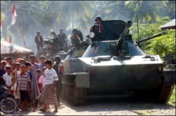
12 Importance of Land Governance Deforestation


13 Importance of Land Governance FDI and Agri-Forestry


14


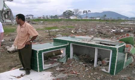
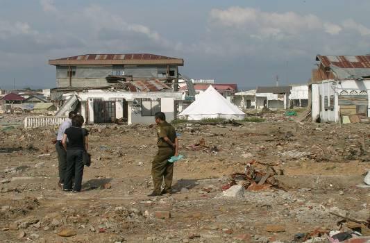
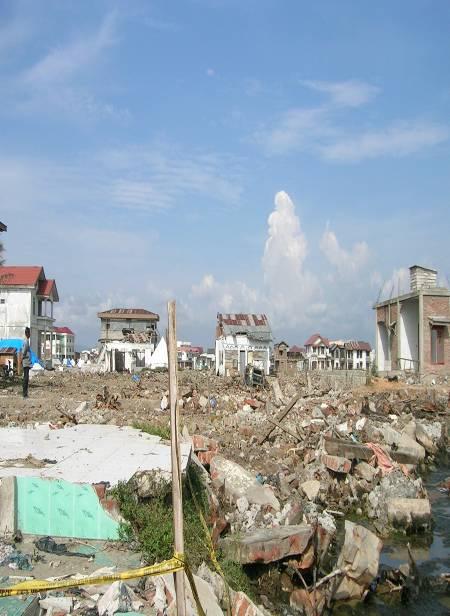

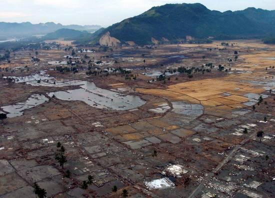
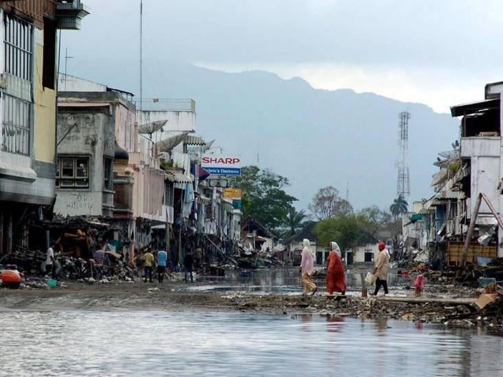
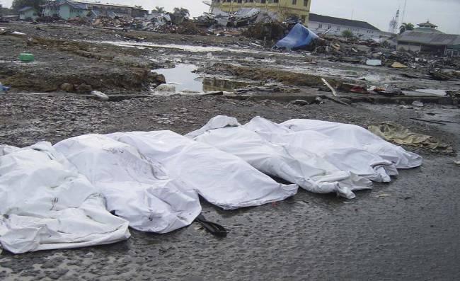

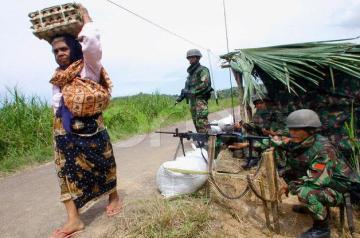
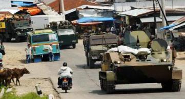
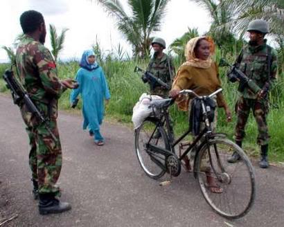
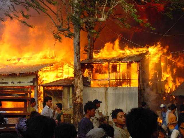
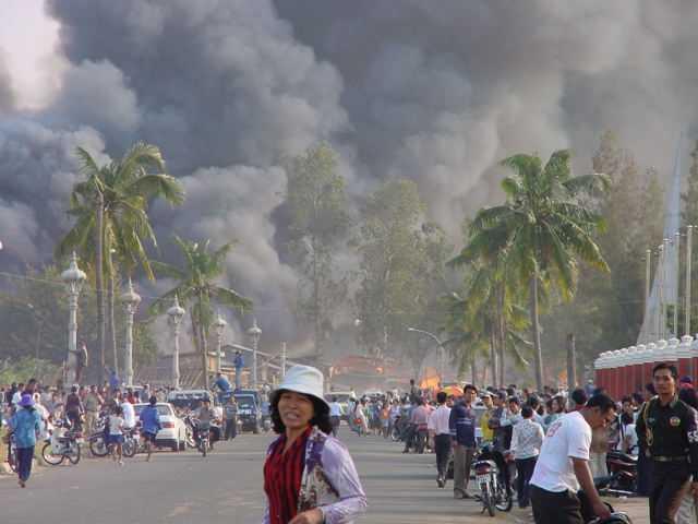
15 Importance of Land Governance - Disasters i 15
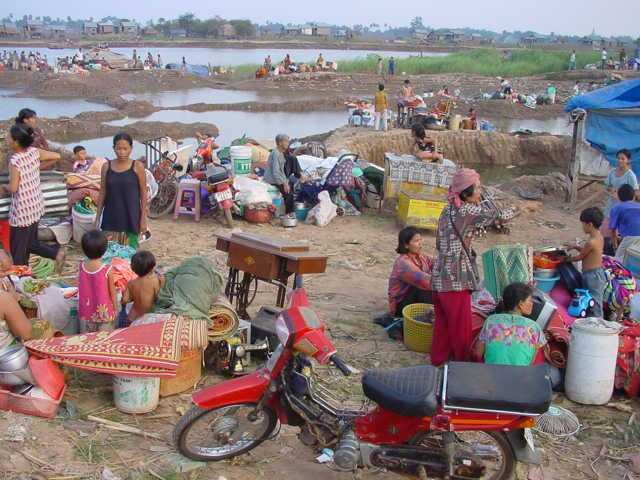


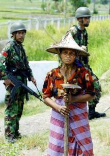
16 Importance of Land Governance Tenure Security & Land Evictions 16
17 World Bank Support for Land FY2010 The World Bank has been directly engaged in supporting the land sub-sector for more than 30 years: (i) policy development, analytical studies, technical assistance; (ii) investment lending for development & reconstruction. Currently the World Bank is supporting land administration projects $US $1.5 billion (global) and $US 180 million (East Asia). These projects have had varying emphases on institutional & policy reform, capacity building, tenure security, land management, governance, social equity, economic development, & service delivery - and more recently SDI
18 Some Key Considerations for Land Sector Very strong statements from World Bank, including President and Managing Directors on importance of land sector World Development Reports, since 2007 have consistently emphasized a need to scale-up land sector support WDRs since 2007 have increasingly stressed the importance of utilization of geospatial data & far more broadly than land sector Land sector reforms are complex and cross-sectoral - requiring broadly based development strategy that addresses the wider social, economic, natural resources & environmental agenda Land sector reform requires long-term engagement Land sector reforms closely aligned to achieving the Millenium Development Goals (MDG) Land governance underpins land sector reform
19 Key ICT Investments in Land Administration - WB support Computerization of databases and land registries Mapping and GIS GPS, CORS Online public access Service delivery internal and external NSDI Computerized valuation and land tax Modalities of Investment: Government and also PPP
20 Spatial Enablement - 3 Significant Trends Have Emerged of Particular Relevance to WB Emergence of neo-geography and the geospatial web is leading to many more bottom- up approaches to adoption & application of geospatial technology - Crowd-sourced and other user generated maps - Editable public maps, online map versioning, user feedback (statistics, ratings, tags, comments) - More informal bottom up SDI Mobile geospatial applications & the growth in location based services, incorporating citizen based data inputs from mobile phones & social media. Highly Operational Earth Observation (EO) Services: (i) standard satellite sensors; (ii) constellations of satellites for regular delivery of products; (iii) creation of large institutional markets for these products to drive down costs
21 New WB Initiatives in Spatial Enablement 1.Crowd Sourced Mapping Community Driven Development Disaster Preparedness and Response 2.Global Facility for Disaster Risk Reduction (GFDRR) 3.Global Monitoring for Environment and Security (GMES) Joint initiative of the European Commission & ESA -aims at achieving autonomous & operational EO Pull together all info from environ satellites, air & ground stations to provide a comprehensive picture of the "health" of Earth. The World Bank has a cooperative agreement with the European Space Agency to pilot services built around GMES.
22 New WB Initiatives in Spatial Enablement (cont.) 4.The Forest Carbon Partnership Facility (FCPF) WB program to assist developing countries in their efforts to reduce emissions from deforestation & land degradation (REDD). Designing & implementing accurate measurements, monitoring & verification systems to enable countries to report on emissions from deforestation & forest degradation. Satellite imagery & other geospatial information are essential for monitoring of REDD.

23 GFDRR Global Partnership
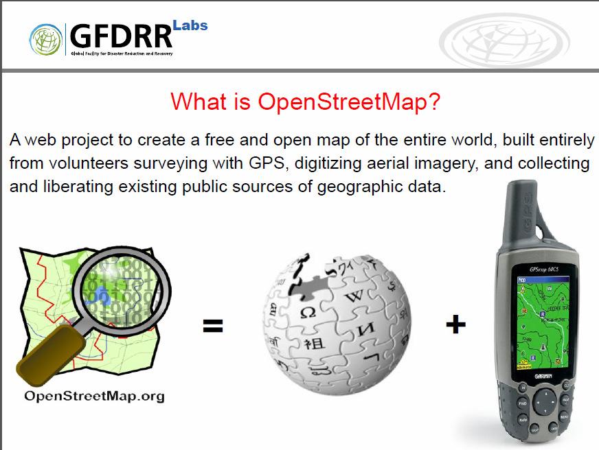
24 GFDRR OpenStreetMap

25 GFDRR Response to Haiti
26 Pacific Catastrophe Risk Assessment and Financing Initiative (PCRAFI) A joint initiative by the World Bank, the Asian Development Bank, and Pacific Islands Applied Geoscience Commission (SOPAC) Co-funded by the Japan Policy and Human Resources Development Fund and the Global Facility for Disaster Reduction and Recovery (GFDRR secretariat at WB) With technical assistance from other institutes including Geoscience Australia
 Framework to direct resources of countries and development partners based on actual risk Pacific disaster risk financing solutions Fiscal risk exposure Financial disaster risk")
27 Pacific Catastrophe Risk Assessment and Financing Initiative Pacific disaster risk assessment Probabilistic assessment of major perils: earthquakes (and tsunami), tropical cyclone (wind, storm surge and precipitation) Framework to direct resources of countries and development partners based on actual risk Pacific disaster risk financing solutions Fiscal risk exposure Financial disaster risk management Regional risk pooling 27
28 Developing country-specific and regional catastrophe risk models for the first time in the Pacific Event Generation Intensity Calculation Damage Estimation Exposure Information Limit Deductible Mitigation Policy / Policy Conditions Conditions Loss Calculation


29 Major effort in assembling, processing & organizing the largest collection of geo-referenced datasets in the region Satellite imagery Administrative Boundaries Population Census Data Agricultural Census Data Surface Geology Maps Topographic maps Surface soil maps Bathymetry maps Infrastructure maps (e.g., roads, bridges, Utilities, etc.) Geodetic & Fault Data Hundreds of references
30 Some Key Challenges Spatially enablement versus spatially dependence Development investment is demand driven - social, economic, environment etc. reforms not technology driven or supply driven Calibration of geospatial investments to meet specific country requirements, including capacity & sustainability Data quality AAA versus non-official Templating solutions from elsewhere without due regard to local conditions, laws etc. Understanding local capacity, laws, governance etc Spatial lobbyists, vendors, consultants different agendas, independence of expert advice
31 Conclusions Investment in land administration systems should explicitly see the development of the NSDI & spatial enablement of the government as part of overall reform, which facilitates an expanded agenda that includes land governance, social development, sustainable management of natural resources and the environment, disaster prevention, climate change, carbon monitoring. Land-related issues will continue to be high priority areas of engagement by the WB - food security, climate change, disaster mitigation and response, poverty alleviation, growing urbanization, carbon, conflict, human rights. The importance of the cadastre, in its broadest sense, and its governance, remains paramount in almost all development interventions. Spatial data will increasingly be sourced from non-official sources Investments need to be calibrated for the specific country requirements, including capacity & sustainability.
32 THANK YOU!
The Message FIG-WB Partnership on Land Governance in Support of the Global Agenda
 FIG-WB Partnership on Land Governance in Support of the Global Agenda Prof. Stig Enemark, Denmark President 2007-2010 Mr. Teo Chee Hai, Malaysia President Elect 2011-2014 WORLD BANK LAND GROUP, WASHINGTON,
Land Administration in support of the Global Agenda: Current FIG Policies
 Land Administration in support of the Global Agenda: Current FIG Policies Prof. Stig Enemark President Aalborg University, Denmark FIG COMMISSION 7 ANNUAL MEETING VERONA, ITALY, SEPTEMBER 2008 Current
Greetings from Denmark. Property Rights, Restrictions and Responsibilities - A Global Land Management Perspective. Wonderful Copenhagen
 Property Rights, Restrictions and Responsibilities - A Global Land Management Perspective Greetings from Denmark 43,000 sq km Prof. Stig Enemark President Aalborg University, Denmark Aalborg Copenhagen
Spatial Enablement and the Response to Climate Change and the Millennium Development Goals
 Spatial Enablement and the Response to Climate Change and the Millennium Development Goals Prof. Stig Enemark President Aalborg University, Denmark 18th UNITED NATIONS REGIONAL CARTOGRAPHIS CONFERENCE
LAND TENURE IN ASIA AND THE PACIFIC CHALLENGES, OPPORTUNITIES AND WAY FORWARD
 LAND TENURE IN ASIA AND THE PACIFIC CHALLENGES, OPPORTUNITIES AND WAY FORWARD Workshop on Land Administration and Management 20th United Nations Regional Cartographic Conference for Asia and the Pacific
Addressing Land Sector Opportunities with Geospatial Information in Nepal
 The 20th UNRCC-AP and the 4th UN-GGIM-AP 5-10 October 2015 Jeju Island, Republic of Korea Addressing Land Sector Opportunities with Geospatial Information in Nepal Krishna Raj BC Executive Director Land
Click to edit Master title style
 Click to edit Master title style Modern Cadastre and Land Administration Session 5a. The toolbox approach Jude Wallace 2007 Click to edit Overview Master title style Objectives To understand the circumstances
Land Markets and Land Rights in support of the Millennium Development Goals
 Land Markets and Land Rights in support of the Millennium Development Goals A Global Perspective Prof. Stig Enemark President Aalborg University, Denmark 3rd LAND ADMINISTRATION FORUM FOR THE ASIA AND
Scenic Nepal. Land Administration Systems. Outline of Presentation. Interests in land. Rights: Registration and security of tenure positions
 Scenic Nepal Land Administration Systems Managing Rights, Restrictions, and Responsibilities in Land Prof. Stig Enemark President Aalborg University, Denmark SURVEY DEPARTMENT KATHMANDU, NEPAL. 16 FEBRUARY
Spatially Enabled Society Role of the Cadastre
 armasuisse Bundesamt für Landestopografie swisstopo Swiss Federal Directorate for Cadastral Surveying Spatially Enabled Society Role of the Cadastre XXIV FIG International Congress 2010 FIG-Task Force
HOUSING POLICIES THAT SAVE (AND IMPROVE) LIVES, PROTECT ASSETS AND SHIELD ECONOMIES. Sameh Naguib Wahba
 LIVES, PROTECT ASSETS AND SHIELD ECONOMIES. Sameh Naguib Wahba") HOUSING POLICIES THAT SAVE (AND IMPROVE) LIVES, PROTECT ASSETS AND SHIELD ECONOMIES Sameh Naguib Wahba Global Director for Urban and Territorial Development, Disaster Risk Management and Resilience WORLD
HOUSING POLICIES THAT SAVE (AND IMPROVE) LIVES, PROTECT ASSETS AND SHIELD ECONOMIES Sameh Naguib Wahba Global Director for Urban and Territorial Development, Disaster Risk Management and Resilience WORLD
Fit-For-Purpose Land Administration: Guiding Principles FACILITATED BY:
 Fit-For-Purpose Land Administration: Guiding Principles 1. GLTN overview - GLTN BRIEFING AND PROGRAMME 2. Geospatial Data - Sustainable Development - 3. Fit-for-purpose Land Administration Guiding Principles
Challenges for the multi purpose cadastre
 Jens RIECKEN, Markus SEIFERT, Germany Key words: Multi purpose cadastre, 3d-cadastre, land use, SDI, solar cadastre SUMMARY Over the past 30 years, with the progress of information technologies the development
Facing the global agenda Outline of presentation
 The global surveying profession Global Trends towards a Spatially Enabled Society Prof. Stig Enemark President Aalborg University, Denmark AREAL OG EJENDOM 2009 - NORGES JORDSKIFTEKANDIDATFORENING VESTBY
Land Governance in Support of The Millennium Development Goals. Stig Enemark Paul van der Molen Robin McLaren
 Land Governance in Support of The Millennium Development Goals Stig Enemark Paul van der Molen Robin McLaren INV 1 - Land Governance in Support of the Millennium Development Goals Sydney, Australia, 11-16
CADASTRE 2014: New Challenges and Direction
 CADASTRE 2014: New Challenges and Direction Anna KRELLE and Abbas RAJABIFARD, Australia Key words: Cadastre, Cadastre 2014, Land Administration SUMMARY Land and land related activities form part of the
AFRICA REGIONAL NETOWORK
 Facing the Global Agenda - The Role of Land Professionals Prof. Stig Enemark FIG Honorary President Aalborg University, Denmark AFRICA REGIONAL NETOWORK Challenges and Opportunities in Facing the SDG s:
PCC conference Tällberg. Aspects on development cooperation
 PCC conference Tällberg Aspects on development cooperation PCC conference Tällberg WHO I AM Anders Åberg, Project Leader Posted over seas 10 years Tanzania 1978 1980 Vietnam 1987 1990 Laos 2004 2008 Now
Adequate Shelter for All Sustainable Human Settlements Development in an Urbanising World
 KARIBU Welcome! UN-HABITAT Urban Policies and Operations 00 UN-HABITAT Implementing the Habitat Agenda (Istanbul 996) Adequate Shelter for All Sustainable Human Development in an Urbanising World YEAR
The agenda for a Group of Experts on Land Administration and Management within the United Nations
 Presented at the FIG Working Week 2016, May 2-6, 2016 in Christchurch, New Zealand The agenda for a Group of Experts on Land Administration and Management within the United Nations Kees de Zeeuw, Kadaster
National Spatial Data Infrastructure development in Republic of Macedonia
 National Spatial Data Infrastructure development in Republic of Macedonia Sonja Dimova, state advisor for geomatics AGENCY FOR REAL ESTATE CADASTRE September 6-th, 2017, Strasbourg AREC competence for
Good Land Governance for the 2030 Agenda
 Good Land Governance for the 2030 Agenda Addis Ababa, Ethiopia 20-22 April, 2014 Role of Geospatial Information in Good Land Policy and Governance Oumar Sylla UN-Habitat/GLTN oumar.sylla@unhabitat.org
National Technical University of Athens School of Rural and Surveying Engineering
 National Technical University of Athens School of Rural and Surveying Engineering INFORMAL SETTLEMENTS REAL ESTATE MARKET NEED FOR GOOD LAND ADMINISTRATION AND PLANNING FIG COM3, UNECE CHLM & WPLA JOINT
LAND ISSUES AND GEO-INFORMATION: RESPONDING POST DISASTER EARTHQUAKES IN NEPAL
 LAND ISSUES AND GEO-INFORMATION: RESPONDING POST DISASTER EARTHQUAKES IN NEPAL ARBIND MAN TULADHAR FACULTY OF GEO-INFORMATION SCIENCE AND EARTH OBSERVATION (ITC), UNIVERSITY OF TWENTE, THE NETHERLANDS,
Land Tools for Tenure Security for All
 Land Tools for Tenure Security for All PROF. JAAP ZEVENBERGEN UNIVERSITY OF TWENTE - ITC 1 ST JUNE 2017 HELSINKI, FINLAND GLOBAL LAND CHALLENGES 70 % Dealing with the affordability issue - how to modernize
Land Policy: Challenge. Securing Rights to Reduce Poverty and Promote Rural Growth THE WORLD BANK SYNOPSIS
 THE WORLD BANK Land Policy: Securing Rights to Reduce Poverty and Promote Rural Growth SYNOPSIS Modern, efficient and transparent land administration systems are important in reducing poverty, and promoting
PROJECT INFORMATION DOCUMENT (PID) APPRAISAL STAGE Report No.: PIDA Project Name. Region Country Sector(s) Theme(s)
 APPRAISAL STAGE Report No.: PIDA Project Name. Region Country Sector(s) Theme(s)") Public Disclosure Authorized Public Disclosure Authorized Public Disclosure Authorized Public Disclosure Authorized Project Name Region Country Sector(s) Theme(s) Lending Instrument Project ID Borrower(s)
Public Disclosure Authorized Public Disclosure Authorized Public Disclosure Authorized Public Disclosure Authorized Project Name Region Country Sector(s) Theme(s) Lending Instrument Project ID Borrower(s)
Esri Middle East and Africa User Conference. December Abu Dhabi, UAE. Land Administration. Mark Baker
 Esri Middle East and Africa User Conference December 10 12 Abu Dhabi, UAE Land Administration Mark Baker Our Agenda 0900 0930 Welcome Mark Baker, Esri 0930 1030 New Directions The New Addressing System
Flying high and Keeping the feet on the ground
 Building the Capacity The FIG Agenda and Achievements 2007-2010 Prof. Stig Enemark President FACING THE CHALLENGES BUILDING THE CAPACITY FIG CONGRESS, SYDNEY, AUSTRALIA, 11-16 APRIL 2010 The Agenda Building
Cadastre: definitions
 Introduction New vision towards a multipurpose cadastral system to support land management in Morocco Moha EL-AYACHI, El Hassane SEMLALI, Mohamed ETTARID, Driss TAHIRI, Institut Agronomique et Vétérinaire
FIG-WB Forum on Land Administration
 FIG-WB Forum on Land Administration and Reform in Sub-Sahara Africa [Nigeria] [Peter O. Adeniyi] FIG WORKING WEEK, Abuja, NIGERIA 2013-6-10 MAY 2013 Statistic Country at a Glance Total population 162,470,737
Re-engineering engineering the cadastre to support e-governmente
 Centre for SDIs and Land Administration Department of Geomatics Re-engineering engineering the cadastre to support e-governmente Ian Williamson UN sponsored Third Land Administration Forum, Tehran, 2009
Chapter 3: A Framework for a National Land Information Infrastructure
 Chapter 3: A Framework for a National Land Information Infrastructure Brian Marwick Overview As a federated county, Australia s land administration systems are state and territory based. These systems,
Lessons for federated countries that have state land registries the Australian experience
 Lessons for federated countries that have state land registries the Australian experience Ian Williamson Centre for SDI and Land Administration Department Infrastructure Engineering University of Melbourne
Participants of the Ministerial Meeting on Housing and Land Management on 8 October 2013 in Geneva
 Summary At its meeting on 2 April 2012, the Bureau of the Committee on Housing and Land Management of the United Nations Economic Commission for Europe agreed on the need for a Strategy for Sustainable
The Bathurst Declaration on Land Administration for Sustainable Development
 United Nations and International Federation of Surveyors The Bathurst Declaration on Land Administration for Sustainable Development The Story The cumulative evolution of society s land administration
Keith Clifford Bell EASER. December 15, 2010 pm MC2-800 ; 12:30-2:30
 Keith Clifford Bell EASER December 15, 2010 pm MC2-800 ; 12:30-2:30 The context and challenges. Interventions in Aceh land sector. RALAS. Study Gender Impacts of Land Titling in Aceh. Considerations for
International funding projects in Republic Geodetic Authority
 International funding projects in Republic Geodetic Authority Serbia: Republic Geodetic Authority Workshop Exploring Funding Instruments for NMCA 7-8 November 2012 Republic Geodetic Authority Republic
Meeting the Changing National Geospatial Information Needs. Palitha Udayakantha Surveyor General - Sri Lanka
 Meeting the Changing National Geospatial Information Needs Palitha Udayakantha Surveyor General - Sri Lanka Sri Lanka Location Latitude 5 55 10-9 50 6 North Longitude 79 31 19-81 52 36 East Area 65610
PROJECT INFORMATION DOCUMENT (PID) CONCEPT STAGE Report No.: AB3229 Project Name. Land Registry and Cadastre Modernization Project Region
 CONCEPT STAGE Report No.: AB3229 Project Name. Land Registry and Cadastre Modernization Project Region") PROJECT INFORMATION DOCUMENT (PID) CONCEPT STAGE Report No.: AB3229 Project Name Land Registry and Cadastre Modernization Project Region EUROPE AND CENTRAL ASIA Sector Central government administration
PROJECT INFORMATION DOCUMENT (PID) CONCEPT STAGE Report No.: AB3229 Project Name Land Registry and Cadastre Modernization Project Region EUROPE AND CENTRAL ASIA Sector Central government administration
Land Information System as new instrument for Land Administration: Case Examples. Mike Cheremshynskyi Consultant, Land Administration Expert
 Land Information System as new instrument for Land Administration: Case Examples Mike Cheremshynskyi Consultant, Land Administration Expert Background Growth of population and fast urbanization in many
Smart Infrastructure Benefits and Key Players from a Global Perspective
 Smart Infrastructure Benefits and Key Players from a Global Perspective Spatial@gov 2010 October 5-7 Canberra Jude Wallace and Abbas Rajabifard Centre for Spatial Data Infrastructures and Land Administration
Cadastral Template 2003
 PCGIAP-Working Group 3 "Cadastre" FIG-Commission 7 "Cadastre and Land Management" Cadastral Template 2003 The establishment of a cadastral template is one of the objectives of Working Group 3 "Cadastre"
Land Tenure and Geospatial Data and Technology
 Land Tenure and Geospatial Data and Technology Ioana Bouvier E3/Land and Urban, USAID Senior Geospatial Analyst January 23, 2018 January 23, 2018 1 OUTLINE 1. Overview of geospatial data and technology
THE 2030 AGENDA, CITIES AND URBAN GOVERNANCE A CENTRAL ROLE FOR LAND AND GEOSPATIAL INFORMATION
 THE 2030 AGENDA, CITIES AND URBAN GOVERNANCE A CENTRAL ROLE FOR LAND AND GEOSPATIAL INFORMATION Abbas Rajabifard Immediate Past President and Executive Board Member, GSDI Association Director, Centre for
Reconstruction in Haiti: A Land Rights Infrastructure to Support its Sustainable Development. Context in Haiti
 Reconstruction in Haiti: A Land Rights Infrastructure to Support its Sustainable Development Daniel Roberge Michel Paradis Mike Mora Sydney, Australia April 14 th 2010 Context in Haiti Haiti is the poorest
The Added Value of Geospatial Information in Disaster and Risk Management: A Case Study on the 2009 Flooding in Namibia
 The Added Value of Geospatial Information in Disaster and Risk Management: A Case Study on the 2009 Flooding in Namibia Summary Tessa Anne Belinfante, M.Sc. VU University Amsterdam Objective and Approach
Implementing Agency Department of Housing, Ministry of Local Government, Urban Development, Housing and Environment
 Public Disclosure Authorized Public Disclosure Authorized Public Disclosure Authorized Public Disclosure Authorized PROJECT INFORMATION DOCUMENT (PID) IDENTIFICATION/CONCEPT STAGE Report No.: PIDC56649
Seventh Session of the United Nations Committee of Experts on Global Geospatial Information Management
 Report of the Forum P a g e 1 Seventh Session of the United Nations Committee of Experts on Global Geospatial Information Management Report of the Forum Secure Land Rights and Smart Cities - Making It
Carbon Finance and Land Tenure Lessons from Sub-Saharan Africa
 Carbon Finance and Land Tenure Lessons from Sub-Saharan Africa Andre Aquino Andre Aasrud Leticia Guimaraes 2 nd World Agroforestry Conference Nairobi, August 24, 2009 Work in progress Harnessing the carbon
REPORT 2014/050 INTERNAL AUDIT DIVISION. Audit of United Nations Human Settlements Programme operations in Sri Lanka
 INTERNAL AUDIT DIVISION REPORT 2014/050 Audit of United Nations Human Settlements Programme operations in Sri Lanka Overall results relating to the effective and efficient implementation of the UN-Habitat
STATUS REPORT
 Working Group 3 Land Administration STATUS REPORT 2006-2009 2009 Prof Ian Williamson (Chair) Mr Ahmad Fauzi Nordin (Vice Chair) Assoc. Prof Abbas Rajabifard (Vice Chair) 18th UNRCC-AP Conference Bangkok
TCP PROJECT AGREEMENT SUPPORT GOVERNMENT IN FORMULATION OF A NATIONAL AND GENDER SENSITIVE LAND POLICY GUIDED BY THE VGGT PRINCIPLES
 TCP PROJECT AGREEMENT SUPPORT GOVERNMENT IN FORMULATION OF A NATIONAL AND GENDER SENSITIVE LAND POLICY GUIDED BY THE VGGT PRINCIPLES THE PROBLEM Insecure tenure rights Property rights contestation Poor
Providing access to land: challenges and solutions Lessons learnt by members of the International Land Coalition
 Providing access to land: challenges and solutions Lessons learnt by members of the International Land Coalition CSD17 Capacity Building Workshop Bangkok, 28-30 January 2009 Dr Michael Taylor, Programme
LAND REFORM IN MALAWI
 LAND REFORM IN MALAWI Presented at the Annual Meeting for FIG Commission 7 In Pretoria, South Africa, Held From 4 th 8 th November, 2002 by Daniel O. C. Gondwe 1.0 BACKGROUND Malawi is a landlocked country
New Developments in the Hellenic Cadastre
 New Developments in the Hellenic Cadastre Prof. M. Kavouras Vice-president Ktimatologio S.A. (Hellenic Cadastre) The Hellenic Cadastre Background The Hellenic National Cadastre Organizational and institutional
Commission 7, Land Administration and IT. Paul van der Molen INTERNATIONAL INSTITUTE FOR GEO-INFORMATION SCIENCE AND EARTH OBSERVATION
 Commission 7, Land Administration and IT Paul van der Molen INTERNATIONAL INSTITUTE FOR GEO-INFORMATION SCIENCE AND EARTH OBSERVATION FIG Commission 7 on cadastre and land management Study Visits (e.g.
Quality Improvement of the Real Estate Cadastre in Serbia
 , Serbia Key words: quality improvement, real estate information, quality assurance, Serbia SUMMARY The concept of cadastral modernization in the Republic of Serbia was defined in 1992, and it is being
LAND ADMINISTRATION DEVELOPMENTS IN RWANDA
 LAND ADMINISTRATION DEVELOPMENTS IN RWANDA, Rwanda Key words : Land tenure security, land registration, land rights, land commissions. SUMMARY : The new Rwandan land policy consider appropriate land administration
UN-HABITAT s Mission and Vision. Sustainable urban development Adequate shelter for all
 GLTN contributes to the implementation of pro poor land policies to achieve secure land rights for all www.gltn.net GLTN Secretariat, facilitated by PO Box 30030, Nairobi 00100, Kenya Tel: +254 20 762
Land surveying is probably the (second) oldest profession in the world
 oldest profession in the world") Land Surveying and Land Management in an International Perspective Prof Stig Enemark Honorary President Aalborg University, Denmark CADASTRE IN A DIGITAL WORLD NORDIC AND GLOBAL PRESPECTIVES INTERNATIONAL
Land Surveying and Land Management in an International Perspective Prof Stig Enemark Honorary President Aalborg University, Denmark CADASTRE IN A DIGITAL WORLD NORDIC AND GLOBAL PRESPECTIVES INTERNATIONAL
Centre for SDIs and Land Administration Department of Geomatics Spatial systems to support sustainable development
 Centre for SDIs and Land Administration Department of Geomatics MODERN CADASTER and LAND ADMINISTRATION تهران-مرداد 1386 2014 ..... 2 ماه Centre for SDIs and Land Administration Department of Geomatics
Building Integrated Land Information Systems and Development of NSDI
 Stig JÖNSSON, Sweden Key words: Land administration, land information systems, property formation, spatial data infrastructure, Inspire, institutional cooperation SUMMARY Lantmäteriet the Swedish agency
Croatian SDI: a Tool for Accelerated Development of the Geo-Conscious Society
 STATE GEODETIC ADMINISTRATION Croatian SDI: a Tool for Accelerated Development of the Geo-Conscious Society Prof.Dr.Sc. Željko Bačić, Mr.Sc. Ljerka Rašić FIG Working Week 2009 - Surveyors Key Role in Accelerated
FIG-WB Forum on Land Administration and reform in Sub-Sahara Africa
 FIG-WB Forum on Land Administration and reform in Sub-Sahara Africa Chris Mnyanga Ministry of Lands UNITED REPUBLIC OF TANZANIA] FIG WORKING WEEK, Abuja, NIGERIA 2013-6-10 MAY 2013 Country at Glance UNITED
People, Politics and Places - responding to the Millennium Development Goals
 LAND POLICIES & LEGAL EMPOWERMENT OF THE POOR INTERNATIONAL WORKSHOP, WOLD BANK, WSHINGTON, 2-3 NOVEMBER 2006 1. INTRODUCTION People, Politics and Places - responding to the Millennium Development Goals
Key Concepts, Approaches and Tools for Strengthening Land Tenure Security
 Key Concepts, Approaches and Tools for Strengthening Land Tenure Security Dr. Samuel Mabikke Land & GLTN Unit / UN-Habitat Urban CSO Cluster Learning Exchange on Strengthening Land Tenure Security for
Land and the New Urban Agenda EGM June 2016
 EGM June 2016 Filiep Decorte Deputy Director New York Liaison Office UN-Habitat 2 August 2016 ROLE OF LAND IN URBAN DEVELOPMENT The New Urban Agenda is about people People need a place to live. Place means
LIS a motivation for SDI initiative
 Eric Mwaikambo Ardhi University Dar es Salaam Tanzania Overview Status of LIS in Tanzania Relationship between SDI and LIS Spatial Standards LIS a motivation for SDI initiative Conclusion & Recommendations
New Technology for Cadastral Systems. Brent Jones, PE, PLS
 New Technology for Cadastral Systems Brent Jones, PE, PLS Benefits of Good Land Administration Key to addressing global challenges.. Secure Tenure Equitable Land and Property Taxation Support for Government
Technology-driven solutions for the innovation of land administration and management
 Technology-driven solutions for the innovation of land administration and management Technology and economic growth - Studies*find link between technology innovation and national economic prosperity especially,
How Big is Global Insecurity of Tenure?
 Presented at the FIG Working Week 2016, May 2-6, 2016 in Christchurch, New Zealand Know Edge Limited Location Information Innovation How Big is Global Insecurity of Tenure? Dr Robin McLaren Know Edge Ltd,
Social and Economic Benefits of Good Land Administration (Second Edition)
") United Nations Economic Commission for Europe Working Party on Land Administration Social and Economic Benefits of Good Land Administration (Second Edition) Published by HM Land Registry, London, on behalf
United Nations Economic Commission for Europe Working Party on Land Administration Social and Economic Benefits of Good Land Administration (Second Edition) Published by HM Land Registry, London, on behalf
Customary Land Tenure and Responsible Investment in Myanmar. Aung Kyaw Thein Land Core Group
 Customary Land Tenure and Responsible Investment in Myanmar Aung Kyaw Thein Land Core Group A Symbol of land land is symbolically prestigious in many societies A means to power and a form of social security
Building a European Spatial Data Infrastructure: The Role of EuroGeographics
 Building a European Spatial Data Infrastructure: The Role of EuroGeographics Richard Kirwan President of EuroGeographics 1st Congress on Cadastre in the EU 1 Presentation overview EuroGeographics - the
Unified Land Administration for a Better Spatial Infrastructure
 Unified Land Administration for a Better Spatial Infrastructure Gyula IVÁN Institute of Geodesy, Cartography & Remote Sensing FÖMI (HUNGARY) Open Symposium 30th Korean Cadastral Seminar & FIG Commission
UN-HABITAT: Philippines - Overview of the Current Housing Rights Situation and Related Activities
 UN-HABITAT: Philippines - Overview of the Current Housing Rights Situation and Related Activities 1) Background and normative/institutional framework for the promotion and protection of housing rights:
Land Tenure and Land Management Issues for REDD Preparation in Guyana: Framing the Agenda for Policy Discussion
 Land Tenure and Land Management Issues for REDD Preparation in Guyana: Framing the Agenda for Policy Discussion Malcolm D. Childress Sr. Land Administration Specialist The World Bank Paper prepared for
Information contained
 Government Information (Public Access) Act 2009 (GIPA Act) LPI Information Guide 1. Introduction and contents of this guide The Land and Property Information s (LPI) Information Guide tells you in general
Land Consolidation Thesaurus finding common ground. 9 th International LANDNET workshop 3-5 October 2017 Budapest, Hungary
 Land Consolidation Thesaurus finding common ground 9 th International LANDNET workshop 3-5 October 2017 Budapest, Hungary Maxim Gorgan, Land Tenure and Rural Development Specialist, FAO Regional Office
The importance of changes in land surveyors education
 András OSSKÓ Key words: land administration, roles of land surveyors, extended education, lifelong learning SUMMARY It s a world wide experience, especially in developed countries that the interest in
THE LAND GOVERNANCE ASSESSMENT FRAMEWORK (LGAF): GLOBAL EXPERIENCE & LESSONS LEARNED FROM THE PHILIPPINES
: GLOBAL EXPERIENCE & LESSONS LEARNED FROM THE PHILIPPINES") THE LAND GOVERNANCE ASSESSMENT FRAMEWORK (LGAF): GLOBAL EXPERIENCE & LESSONS LEARNED FROM THE PHILIPPINES Folay Eleazar & Keith Clifford Bell August 13, 2013 Why an Assessment of Land Governance is Required
THE LAND GOVERNANCE ASSESSMENT FRAMEWORK (LGAF): GLOBAL EXPERIENCE & LESSONS LEARNED FROM THE PHILIPPINES Folay Eleazar & Keith Clifford Bell August 13, 2013 Why an Assessment of Land Governance is Required
Presentation By Mr. Mduduzi Shabane
 COMMUNAL LAND TENURE REFORM Proposed Policies Presentation By Mr. Mduduzi Shabane The Director General: Department of Rural Development and land Reform 07 th JUNE 2013 COMMUNAL LAND TENURE POLICY BACKGROUND
Presented by: Stewart Information International, Inc. Jack McKenna
 Presented by: Stewart Information International, Inc. Jack McKenna Held at the: 2007 ESRI Survey & Engineering GIS Summit San Diego Convention Center San Diego, California June 16-19, 2007 Integrating
Commission 7 Cadastre and Land Administration. Work Plan
 Commission 7 Cadastre and Land Administration Work Plan 2011 2014 Appendix to item 17.7 1. Title Cadastre and Land Administration 2. Terms of Reference Commission 7 deals with land administration and land
Spatial Data Infrastructure in Sweden
 Spatial Data Infrastructure in Sweden Hans-Erik WIBERG, Sweden Key words: ABSTRACT Sweden was one of the first countries to address Data Infrastructure matters and have during several decades developed
Egyptian Nationwide Title Cadastre System
 Kholoud SAAD, Egypt Key words: Cadastre, Registration, Urban, Rural, National Cadastre, Automation, reengineering. SUMMARY With growing need for integrated information, Enterprise Solutions has become
Overview of PCGIAP-WG3 and Spatially Enabled Government
 Working Group 3 3 rd Land Administration Forum Overview of and Spatially Enabled Government Abbas Rajabifard Vice Chair, Established in 2000 based on a Resolution from the 15th UNRCC-AP in Malaysia. With
Cadastral Futures building a new vision for the nature and role of cadastres. XXIV FIG International Congress Sydney, April 11-15
 Cadastral Futures building a new vision for the nature and role of cadastres XXIV FIG International Congress Sydney, April 11-15 Rohan Bennett, Abbas Rajabifard, Mohsen Kalantari, Jude Wallace, Ian Williamson
Good Governance and Regulatory Frameworks Lessons from the AU Agenda on Land
 Good Governance and Regulatory Frameworks Lessons from the AU Agenda on Land Joan Kagwanja Keynote, High Level Policy Dialogue Fourth High Level Forum on Global Geospatial Information Management (GGIM)
WORLD BANK/IFC 6 TH GLOBAL HOUSING FINANCE CONFERENCE, AFFORDABLE HOUSING FINANCE: THE ROLE OF GOVERNMENT MRS AKON EYAKENYI
 WORLD BANK/IFC 6 TH GLOBAL HOUSING FINANCE CONFERENCE, 28-29 MAY, 2014, WASHINGTON DC, UNITED STATES OF AMERICA. PRESENTATION ON AFFORDABLE HOUSING FINANCE: THE ROLE OF GOVERNMENT BY: MRS AKON EYAKENYI
7 th international LANDNET Conference 5-7 October 2015, Ankara, Turkey. Land banks and land funds an overview and presentation of FAO publication
 7 th international LANDNET Conference 5-7 October 2015, Ankara, Turkey Land banks and land funds an overview and presentation of FAO publication With contributions from Frank van Holst, Francisco Onega
WORKSHOP ON TAX POLICY FOR DOMESTIC RESOURCE MOBILIZATION AND SEMINAR ON PROPERTY TAX REFORM: THE PHILIPPINE REGALA EXPERIENCE
 WORKSHOP ON TAX POLICY FOR DOMESTIC RESOURCE MOBILIZATION AND SEMINAR ON PROPERTY TAX REFORM: THE PHILIPPINE REGALA EXPERIENCE ADBI, Tokyo 20-23 February 2018 The Philippines is at a critical juncture.
Iranian Cadastre System. Nasrollah Jahangard Iran s Deeds and Properties Registration Organization I.R. of Iran 14 th PCGIAP, KL, Malaysia 2008
 Iranian Cadastre System Nasrollah Jahangard Iran s Deeds and Properties Registration Organization I.R. of Iran 14 th PCGIAP, KL, Malaysia 2008 General Information Europe Middle East Asia Africa Middle
Galicia 2009 Regional Workshop on Land Tenure and Land Consolidation. FAO s Experience with Land Development Instruments in Europe
 Galicia 2009 Regional Workshop on Land Tenure and Land Consolidation FAO s Experience with Land Development Instruments in Europe Santiago de Compostela Galicia 9-11 of February 2009 Richard Eberlin Land
Global Eradication of Infectious Diseases
 Global Security of Tenure Campaign the Time of Rights Dr Robin McLaren Land Professional Know Edge Limited Location Information Innovation COMMISSION 7 ANNUAL MEETING, COIMBRA, PORTUGAL OCTOBER 2016 1
NEW CHALLENGES IN URBAN GOVERNANCE AND FINANCE
 Final International Conference Paris January 15-16, 2015 NEW CHALLENGES IN URBAN GOVERNANCE AND FINANCE Zhi Liu Peking University Lincoln Institute of Land Policy Center for Urban Development and Land
Agenda Project Overview Project Objectives Registration Service Re-Engineering System Overview
 Agenda Project Overview Project Objectives Registration Service Re-Engineering System Overview Sydney, Australia, 11 16 April 2010 1 Project Overview Future Vision There is a vision within senior levels
A beautiful setting. The Evolving Role of Cadastral Systems in Support of Good Land Governance. Setting the scene
 The Evolving Role of Cadastral Systems in Support of Good Land Governance Prof. Stig Enemark President Aalborg University, Denmark THE DIGITAL CADASTRAL MAP FIG COMMISSION 7 OPEN SYMPOSIUM KARLOVY VARY,
Securing Land Rights for Broadband Land Acquisition for Utilities in Sweden
 Securing Land Rights for Broadband Land Acquisition for Utilities in Sweden Marija JURIC and Kristin LAND, Sweden Key words: broadband, land acquisition, cadastral procedure, Sweden SUMMARY The European