C-5-17(c), HERMAN H. HARRIS, JR.
|
|
|
- Francine Cameron
- 5 years ago
- Views:
Transcription


 GPTNs 7821-99-5265 General Land")
 and Scenic Road Suburban Service Area Outside Case Planner Gretchen W.")

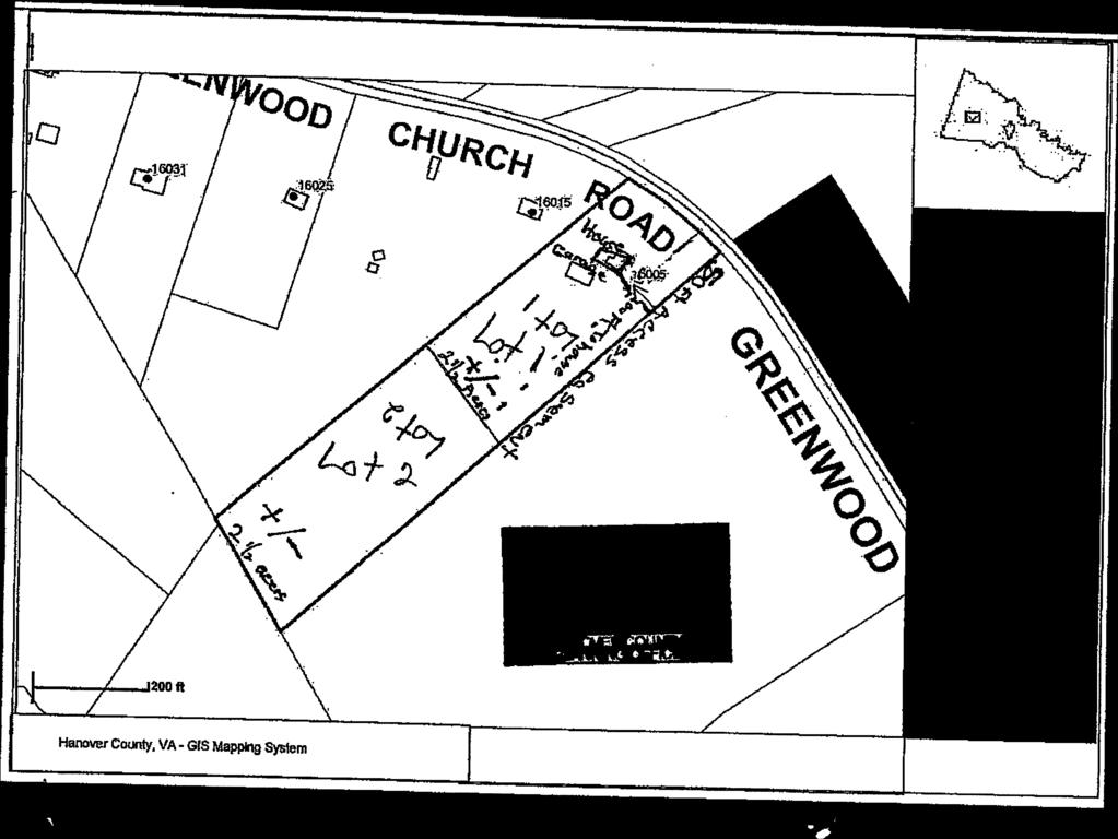
1 Minor C-5-17(c), HERMAN H. HARRIS, JR. Residential Rezoning Report South Anna Magisterial District 17 Overview Of SU? Current Zoning A-i, Agricultural District Requested Zoning AR-6(c), Agricultural Residential District with conditions Requested Density One dwelling unit per 2.49 acres Acreage 4.97 acres Location On the south line of Greenwood Church Road (State Route 657) approximately 1,800 feet east of its intersection with Lone Oak Road (State Route 775) GPTNs General Land Use Plan Agricultural Major Thoroughfare Plan Greenwood Church Road Collector (60 ultimate right-of-way) and Scenic Road Suburban Service Area Outside Case Planner Gretchen W. Biemot Executive Summary The applicant is proposing to rezone to AR-6(c), Agricultural Residential District with conditions to permit the creation of one additional lot. Recommendations Staff APPROVAL subject to the submitted proffers, dated April 25, Planning Commission APPROVAL subject to the submitted proffers, dated April 25, 2017.
, Agricultural Residential District with conditions on GPIN 7821-99-5265, consisting of Proffers Agency Analysis two 2.")
2 LI County Traffic Study LI Citizen Correspondence Summary LI Application Copy Copy Copy E Maps (land use, vicinity, zoning, aerial) E Agency Review Comments GJWB/HTE Mr. Leadbetter, seconded by Ms. Iverson, voted to recommend APPROVAL of the request to rezone to AR-6(c), Agricultural Residential District with conditions on GPIN , consisting of Proffers Agency Analysis two 2.5 acre lots. Staff would note that this is the maximum number of lots that could be created on the parcel under the AR-6 zoning district. Lot 1 contains the existing house and garage. Lot 2, which is currently heavily wooded, is where the applicant would like to construct a new house. The applicant southeastern property line to Lot 2. The existing driveway will be closed. The conceptual plan and plat demonstrate that the lot requirements of AR-6 will be met. Should this rezoning application be approved, the applicant must submit a subdivision plat application for review and approval that is in substantial conformity with the proffered conceptual plan. designation in the Comprehensive Plan and should have little impact to the existing rural residential character of the area. reservation, and limitations on access. Staff recommends approval of the submitted proffers, dated approximately 4.97 acres, subject to the submitted proffers. The applicant has submitted a conceptual plan showing the 4.97 acre subject parcel to be divided into has proffered that access to both lots will be provided by a 50 access easement that runs along the The applicant has submitted proffers pertaining to the conceptual plan, tree preservation, right-of-way This application for AR-6 zoning for one additional lot is consistent with the Agricultural land use There were no substantive comments from any of the reviewing agencies. April 25, At their meeting of April 20, 2017, the Hanover County Planning Commission, on a motion by Planning Analysis Planning Commission Recommendation E Ordinance Proffers/Elevations/Conceptual Plan Il1 Application Materials LI 527 Traffic Study LI 527 Traffic Study LI Photographs LI Historical Commission Recommendation LI County Traffic Study Attachments Available Upon Request Exec. Summary Exec. 2 Full Full Full


 Business-Industrial")


3 Hanover County, Virginia a a a a Land Use Map Legend Agricultural Rural Village Suburban Transitional Suburban General Suburban High Multi-Family Commercial Multi-Use Mixed-Use (LCIHR) Mixed-Use (HC/LR) Business-Industrial Industrial Limited Industrial Planned Business Destination Commerce Flood Plain C-5-17 Herman H. Harris, Jr. Rezone A-I to AR-6 Agricultural Land Use GPIN: South Anna Magisterial District w+ 1 inch = 600 feet February 07, 2017


4 Hanover County, Virginia General Parcel Map Legend Roads Water Trees Private Road Structures Parcels C-5-iZ Herman H. Harris, Jr. Rezone A-I to AR-6 GPIN: South Anna Magisterial District 1 inch = 600 feet February 07, 2077


5 Hanover County, Virginia Zoning Legend C-5-17 Herman H. Harris, Jr. GPIN: South Anna Magisterial District inch = 600 feet FebruanjO7, 2077


6 2013 Aerial 0 0 C-5-17 Herman H. Harris, Jr. WE 240

 ( e i7 Current Zoning 1% 1 Deed Book\ 4 z, Page Requested Zoning F) L Magisterial District C5v+ 14 ri tj Family Division?")
![Yes i i]o Location Description (Street Address, if applicable) General Land Use Plan Designation C L J( c) e t.. 0 k Major Thoroughfare Plan Designation tct % I c_s c.](/docs-images/93/112792841/images/7-3.jpg "1 f ()t) -I SIGNATURE OF OWNEREOWER OF ATTORNEYEZ CONTRACT PURCHASER (attach contract) As owner or authori4ed agent of this property, I hereby certify that this application is complete and accurate")
7 C) Hanover County Planning Department Application Case #: Sl Request for REZONING to AR-6 and RS for one (1) additional lot Please type or print in black ink. APPLICANT INFORMATION Owner: rj H. -,1-3 4i Contact Name: R 4 J 4 - Address: 1 (Oô Gre cc-cl c-d Th.. Telephone No. CI IS% 4 Add ress Applicant/Contract Purchaser: rt A4 J ccf1-c Telephone No. Contact Name: H e- wi t-j Fax No. &% Address: / Er-eeiwôc o( 13 Address CkticJ 1S0c1d. [ PARCEL INFORMATION GPIN(s) (Tax ID #s). _.5 Total Area (acres/square feet) ( e i7 Current Zoning 1% 1 Deed Book\ 4 z, Page Requested Zoning F) L Magisterial District C5v+ 14 ri tj Family Division? Yes i i]o Location Description (Street Address, if applicable) General Land Use Plan Designation C L J( c) e t.. 0 k Major Thoroughfare Plan Designation tct % I c_s c.1 f ()t) -I SIGNATURE OF OWNEREOWER OF ATTORNEYEZ CONTRACT PURCHASER (attach contract) As owner or authori4ed agent of this property, I hereby certify that this application is complete and accurate to the best of my knowiedje, and I authorize County. representatives entry onto the property for purposes of reviewing this request. / // (:1 / - Signature 7-E\ Date.94 y&(/1 Print Nar Signature Date Print, QUESTIONS! LETTERS! REPORTS SHOULD BE FORWARDED TO THE FOLLOWING**: Name Address: Telephone No. Fax No. Address **lt is the responsibility of the contact person to provide copies of all correspondence to other interested parties to the application. 3 RECEIVED HANOVEf COU P1.ANNING OFFICE_
 which includes a listing of all property owners including those across roadways, watercourses,")

8 0 0 ATTACHMENTS - For ALL REQUESTS you must submit the following: LiJ/. a. Acknowledgement of Application Fee Payment Procedure (Page 5) b. Adjacent property owners, Board of Supervisors, and Planning Commissioner notification form (Page 6) which includes a listing of all property owners including those across roadways, watercourses, and/or railroads as well as the members of the Board of Supervisors and Planning Commission for the magisterial district in which the property is located. Adjacent property owners, Board members, and Planning Commissioners must be notified prior to submittal of this application. The form must include owners names, address, and GPIN5 for all adjacent property owners. (This information is available from the County website or can be obtained from the Planning Department.) A sample letter, which is attached / (Page 8), may be used to notify the neighbors. c. A plat of the subject property, which accurately reflects the current property boundaries, includes metes and bounds, is drawn to scale, and shows existing structures. If the full-size plat is larger than 8 4 x 11, the plat must be folded no larger than 9 xl 2, and a reduction of the plat must be submitted which is 8 4 x 11 in size. (Typically available from the County Clerk s Office in the Circuit Court building.) d. Responses to questions on Pages 9 (Please use the space provided) e. Historic Impact Information (Page 10) (This information is available on the County website or the Planning Staff may be asked to assist.) f. Conceptual Plan, including general lot configurations and road locations. When conceptual plans and! or elevations are requested by the Director of Planning which are larger in size than 8% x 11 or are in color, please submit thirteen (13) full-size or colored plans, with sheets no larger than 24 x 36, folded to 9 x 12 in size, and 1-8 % x 11 reduction. 4

9 0 ACKNOWLEDGEMENT OF APPLICATION FEE PAYMENT PROCEDURE Application fees are not accepted at the time of submittal. I hereby acknowledge that this application is not complete until the payment for all applicable application fees has been received by the Hanover County Planning Department. The Hanover County Planning Department shall notify me by mail (at the address listed below) of the applicable fee(s) at such time that they determine that the application is complete and acceptable. I acknowledge that I am responsible for ensuring that such fees are received by the Hanover County Planning Department by the Tuesday the week following the application deadline. I further acknowledge that any application fee submitted after this date shall result in the application being considered filed for the next application deadline. Should the applicable fees not be submitted within forty-five (45) days of the date of the notification letter, it shall be my responsibility to arrange for the retrieval of all application materials. The application and any supplementary materials for incomplete applications that are not retrieved within forty-five (45) days of the date of the notification letter shall be destroyed by the Hanover County Planning Department. Should my application be accepted, my fee pay ent will be due by >2/I-t/J.) i9. Planning Staff member.) / / Signature of ap, licant/authorized agent k ju1 te Print Name [4 ç (To be filled in by a Signature of applicant/authorized agent Print Name Date Address to which notification letter is to be sent: &-- --& [ñ,,4k]1 \j ;D[3 If you would like your letter ed and/or faxed, please make selections, and provide the information below: EEmaiI FEES After application is accepted for review, makeks payabl rhanover County (effective July 1, 2008): RS $1500+ $75/acre* Amendment of Proffer or Planned Unit Development $1 500 *Fractions of acreage are rounded up to the nearest whole number Please note: Applicants which request tax-exempt status may have their application fee waived upon presentation of official documentation of such status. FOR STAFF USE ONLY: Fees: Base Fee 4 o1 Acreage Fee TOTAL Accepted by: HTE#: 5

10 0 0 NOTIFICATION OF ADJOINING PROPERTY OWNERS, BOARD OF SUPERVISORS, AND PLANNING COMMISSIONERS Applicant s Statement: I hereby certify that I have notified all adjacent property owners to the property, which is the subject of this request, as well as the members of the Board of Supervisors and Planning Commission for the magisterial district in which the property is located. Adjacent property includes all property across roadways, watercourses, railroads, and/or municipal boundaries. I furher certify that the names and addresses below are those of the adjacent property owners as listed in tetrecords of the Co issionerf Revenue of Hanover County. Applicant s 44 auul COMMONWEALTH OF VIRGINIA COUNTYOF HANOVER to-wit: The foregoing instrument was acknowledged before me this?4day of tdrlaa1) by J-Iecr-ca (1 j1c?lsjojyd f+c1yc Tç (Name of Applicant). w My commission expires: 03/3 i/ / Notary Public Board of Supervisors Representative: -.- Planning Commission Representative: List of Adjacent Property Owners: JCheck here is list is attached. ui. -1?i;iL.- r P(%?>: \ 78 - GPIN Name Address 6


11 CARMAN, MARK R & BARBARA R REVO DEC FREEMAN, JAMES & ELNORA BRAXTON ANDERSON, SHEILA H & CLARENCE M R/S NICHOLAS, BERTHA H GREENWOOD CHURCH ROAD N & C DRIVE GREENWOOD CHURCH ROAD 4934 SHADY GROVE ROAD HEWLETT ROAD HALL, MELISSA HEATH & JOHN A R/S GPIN OWNERNAM E MAILI NGADD ZIPCODE 0 CD


12 4 tt JC 0 0 NOTIFICATION OF ZONING APPLICATION SUBMITTAL TO: Adjacent Property Owner FROM: L DATE: (4 (0 The following application will be submitted for review to the Hanover County Planning Department: E LI Rezoning Conditional Use Permit Special Exception nj Property Lbcation: c ee t4 GPIN(s):. - ñle\d %Z S Requested Zoning District: - Requested Use/Exception: - Ldt The application will be available for viewing at the Hanover County Planning Department. The Planning Department shall notify all adjacent property owners of the time, day, and place of the public hearings to be held on this application. Should you have any questions or comments, please contact the Planning Department at (804)

13 0 C) PLEASE RESPOND FOR ALL REZONING APPLICATIONS: (Attach additional pages, if needed) 1. Describe in detail the proposed use of the property. If this additi nal lot is farnil division please i dicate the relationship to property owner. fe3d p L (. t cc 2. Is this request in accordance with the Transportation and/or Family Division Policies? Yes ONo 3. List any sensitive environmental or natural features on the property that deserves protection and preservation, and describe any measures for protection and maintenance. Are tirç apy 1 5Q,kV or greater transmission lines, transmission lines for natural gas, other public utilities, or other entity? I\1( & 4.Is the subject property located in a Dam Break Inundation Zone? EJYes ji (Please contact the Department of Planning or Public Works for assistance in addressing this question.) If yes, please contact the Department of Public Works for further information. 5. What provisions will be made to ensure safe and adequate access to thesubjec!property? If shared access is pqsibie, will itbe utilized? If not, why? v( ty(-. :*i- 4- HISTORIC SITE IMPACT ANALYSIS Please identify any known or suspected historic resources on both the subject property and adjacent properties, to include both structural and non-structural resources, such as trenches, cemeteries, and archeological sites. Please include the GPIN (Tax Parcel Number) associated with the resource. Please attach additional sheets, if necessary. Should you need assistance completing this form, please contact the Planning Staff. 1. Historic Resource/File No. GPIN 2. Historic Resource/File No. GPIN 3. Historic Resource/File No. GPIN If you have identified known or suspected historic resources on the subject property or adjacent property, please provide the following information on each site: a) Is the historic site listed as a National or State Registered Landmark? b) Is the historic site open to the public? c) Describe the impact the proposed request will have on the identified historic resources with regard to noise, traffic, dust, vibration, visual impact, and air pollution. Also, please describe what voluntary measures will be undertaken to help mitigate the impact that the proposed use may have on the identified historic resources. If there are no knpwn or suspected historicjresource, including structural and non-structural resources, trenches, cemeteries, and archeological sites, pies sign an,d date. Signatuf/ fl ii 9 Date:

14 a _ / t i r 3 2 x -1 IN S-h V --3r r n 1 r t1 C t 0 0 -D fl.: - Lw I0 1 1 c/ac 0.: : F S : -:3 N- -(no N. \ / \ /1 ;:, \... :.--.,-..-:--. 1 r -, p -:-. -:::.k -- ;..Z.-s. --, - t V _4. ) : : S n..2-:

15 PROFFERS: C-5-17(c), Herman H. Harris, Jr. The undersigned, Herman H. Harris, Jr., owners of parcel designated GPIN , ( the Property ), voluntarily agrees for themselves, their agent, personal representatives, successors and assigns (collectively the Property Owner ) that, in the event the Property is rezoned from A-i to AR-6, the development and use of the Property shall be subject to the following conditions: 1. Conceptual Plan. The property shall be divided in substantial conformity with the conceptual plan ( the Plan ) attached, titled Herman Conceptual Plan, dated february 21, 2017, and prepared by Herman H. Harris, Jr. 2. Tree Preservation. Existing trees of 5 inch caliper or greater on the Property shall not be removed with the exception of dead or diseased trees or parts thereof. This shall not prevent the removal of trees necessary for the construction of improvements, driveways, drainfields, or drainage facilities. 3. Reservation of Right-of Way. The Owner agrees to reserve thirty (30) feet of right-of-way from the centerline of Greenwood Church Road (State Route 657) to the property for the future road widening. 4. Access. Access to both lots shall be provided by the proposed 50 access ease ent, as shown on the Plan. Lot 1 shall not have direct access to Greenwood /Ch chroad. wner COMMONWEALTH Of VIRGINIA, COUNTY OF HANOVER, to-wit: c/ /%s LU Pt., do hereby certify that rn-i -1o1rrS Icty r, tr. has acknowledged the foregoing Proffers before me, this.1jçlay of /,2017. My Commission Expires: o3/ 3 t / /7 W. /%z (SEAL) Notary Public $,\_p.. fr_np / 1 RECEtVED MV COMMISSION C NUMBER 22 7o8sos %LTh&%


16 .4 D F-. I q I

17 ORDINANCE C-5-17(c) OWNER OF RECORD: HERMAN H. HARRIS, JR. WHEREAS the Planning Commission of Hanover County has held an advertised public hearing and forwarded this case to the Board of Supervisors with a recommendation of APPROVAL of the adoption of the following amendment to the Zoning Ordinance and Zoning District Map of Hanover County; and WHEREAS the Board of Supervisors has held public hearings on the 24th day of May, 2017, and advertised in the Hanover Herald-Progress once a week for two successive weeks as required by Virginia Code Section ; and WHEREAS the Board of Supervisors has determined that the public necessity, convenience, general welfare, and good zoning practices require this amendment. NOW, THEREFORE, BE IT ORDALNED by the Board of Supervisors of Hanover County that the Zoning Ordinance and the Zoning District Map of this County are amended (with conditions) by the rezoning of the property described as GPIN , consisting of 4.97± acres located on the south line of Greenwood Church Road (State Route 657) approximately 1,800 feet east of its intersection with Lone Oak Road (State Route 775), (a detailed description is filed with the Board s papers) from A-i, Agricultural District, to AR-6(c), Agricultural Residential District with conditions, subject to the following conditions which were proffered by the Applicant on April 25, 2017, and accepted by the Board: 1. Conceptual Plan. The property shall be divided in substantial conformity with the conceptual plan ( the Plan ) attached, titled Herman Conceptual Plan, dated February 21, 2017, and prepared by Herman H. Harris, Jr. 2. Tree Preservation. Existing trees of 5 inch caliper or greater on the Property shall not be removed with the exception of dead or diseased trees or parts thereof This shall not prevent the removal of trees necessary for the construction of improvements, driveways, drainfields, or drainage facilities. 3. Reservation of Right-of Way. The Owner agrees to reserve thirty (30) feet of right-of way from the centerline of Greenwood Church Road (State Route 657) to the property for the future road widening. 4. Access. Access to both lots shall be provided by the proposed 50 access easement, as shown on the Plan. Lot 1 shall not have direct access to Greenwood Church Road.


, Herman H. Harris, Jr., adopted by the Hanover County Board of Supervisors on Cecil R. Harris, Jr. County Administrator / Clerk Hanover County Board of Supervisors GJWB/tmb/hte")
18 Dated: BE IT FURTHER ORDAllJED that this Ordinance is effective on the date of adoption and the Planning Director is hereby directed to designate the boundaries of the foregoing area as rezoned, subject to conditions, on the Zoning District Map of Hanover County. On motion of seconded by the members of the Board of Supervisors voted to approve Ordinance C-5-17(c), Herman H. Harris, Jr., as follows: Angela Kelly-Wiecek Sean M. Davis Wayne T. Hazzard W. Canova Peterson, IV Faye 0. Prichard Aubrey M. Stanley Scott A. Wyatt Vote: Public Hearings: Planning Commission April 20, 2017 Board of Supervisors May 24, 2017 Adopted May 24, 2017 This is to certify that the above is a true copy of C-5-17(c), Herman H. Harris, Jr., adopted by the Hanover County Board of Supervisors on Cecil R. Harris, Jr. County Administrator / Clerk Hanover County Board of Supervisors GJWB/tmb/hte
C-22-16(c), HOl H. NGAI AND LYNDA M. PUUNG-NGAI
, HOl H. NGAI AND LYNDA M. PUUNG-NGAI") Major C-22-16(c), HOl H. NGAI AND LYNDA M. PUUNG-NGAI cco Residential Rezoning Report Henry Magisterial District Board Meeting Date: March 22, 2017 Or%d1 c 4 IPG\ Of SIJ? Overview Current Zoning A-i, Agricultural
Major C-22-16(c), HOl H. NGAI AND LYNDA M. PUUNG-NGAI cco Residential Rezoning Report Henry Magisterial District Board Meeting Date: March 22, 2017 Or%d1 c 4 IPG\ Of SIJ? Overview Current Zoning A-i, Agricultural
sofl C-16-16(c), AM. 1-17, C. DENTON AND LAURA BAKER
, AM. 1-17, C. DENTON AND LAURA BAKER") Minor not C-16-16(c), AM. 1-17, C. DENTON AND LAURA BAKER Commercial Rezomng Amendment Report - Beaverdam Magisterial District Board Meeting Date: March 22, 2017 Overview IRGI Op sofl Amendment Request
Minor not C-16-16(c), AM. 1-17, C. DENTON AND LAURA BAKER Commercial Rezomng Amendment Report - Beaverdam Magisterial District Board Meeting Date: March 22, 2017 Overview IRGI Op sofl Amendment Request
C-24-16, RICHARD KENNETH JOHNSON
 C-24-16, RICHARD KENNETH JOHNSON Residential Rezoning Report 2017 Overview Of SU? Current Zoning A-i, Agricultural District Requested Zoning AR-6(c), Agricultural District with conditions Requested Density
c,, C-23-16(c), BLUE RIDGE CUSTOM HOMES Residential Rezoning Report South Anna Magisterial District PC Meeting Date: March 16, 2017 C (ø
, BLUE RIDGE CUSTOM HOMES Residential Rezoning Report South Anna Magisterial District PC Meeting Date: March 16, 2017 C (ø") C-23-16(c), BLUE RIDGE CUSTOM HOMES Residential Rezoning Report South Anna Magisterial District PC Meeting Date: March 16, 2017 Overview c,, JckFQ C (ø Current Zoning A-i, Agricultural District Requested
C-23-16(c), BLUE RIDGE CUSTOM HOMES Residential Rezoning Report South Anna Magisterial District PC Meeting Date: March 16, 2017 Overview c,, JckFQ C (ø Current Zoning A-i, Agricultural District Requested
0f SU? SE-8-17, JILL T. & THOMAS G. VOEKLER. Special Exception Report South Anna Magisterial District Board Meeting Date: August 23, 2017 c.
 SE-8-17, JILL T. & THOMAS G. VOEKLER Special Exception Report South Anna Magisterial District Board Meeting Date: August 23, 2017 c Overview 0f SU? Request Special Exception Permit to permit a private
CUP-14-93, AM. 1-17, SAINT SERAPHIM OF $AROV ORTHODOX CHURCH
 CUP-14-93, AM. 1-17, SAINT SERAPHIM OF $AROV ORTHODOX CHURCH Conditional Use Permit Amendment Report South Anna Magisterial District, PC Meeting Date: June 15, 2017 IRG C Overview Request To amend the
BARROW COUNTY, GEORGIA
 BARROW COUNTY, GEORGIA Application For Rezoning, Special Use, and Change in Conditions BARROW COUNTY DEPARTMENT OF PLANNING AND DEVELOPMENT 30 North Broad Street Winder, Georgia 30680 770-307-3034 APPLICATION
COUNTY OF ALBEMARLE APPLICATION FOR RURAL SUBDIVISION
 Page 1 APPLICATION FOR RURAL SUBDIVISION The term rural subdivision means a type of subdivision that is located in the rural areas which results in two or more lots for the purpose of transfer of ownership
Preliminary Plat/Final Plat Application
 Melissa Municipal Center 3411 Barker Avenue Melissa, Texas 75454 Phone: (972) 838-2036 Applicant: Date: Address: Phone: Contact: Fax: E-mail: Propose Addition Name: Acres: Existing Zoning: Propose Zoning:
CITY OF NEWNAN, GEORGIA
 CITY OF NEWNAN, GEORGIA Application Form For Special Exception July, 2000 Revised June, 2003 Application revised July, 2007 CITY OF NEWNAN, GEORGIA 25 LaGrange Street Newnan, Georgia 30263 770-254-2354
C-16-16(c), LAURA S. AND C. DENTON BAKER (GAYLE A. AND JEFFREY S. STONEMAN)
, LAURA S. AND C. DENTON BAKER (GAYLE A. AND JEFFREY S. STONEMAN)") Minor not C-16-16(c), LAURA S. AND C. DENTON BAKER (GAYLE A. AND JEFFREY S. STONEMAN) Commercial Rezoning Report... Beaverdarn Magisterial District PC Meeting Date: October 20, 2016 Overview Current Zoning
Minor not C-16-16(c), LAURA S. AND C. DENTON BAKER (GAYLE A. AND JEFFREY S. STONEMAN) Commercial Rezoning Report... Beaverdarn Magisterial District PC Meeting Date: October 20, 2016 Overview Current Zoning
City of Melbourne APPLICATION FOR PRELIMINARY PLAT
 City of Melbourne Community Development Department City Hall 900 E. Strawbridge Avenue, Melbourne, FL 32901 (321) 608-7500 Fax (321) 608-7519 E-Mail p&z@melbourneflorida.org APPLICATION FOR PRELIMINARY
APPLICATION PACKET SINGLE FAMILY CLUSTER HOUSING OPTION REVIEW
 APPLICATION PACKET SINGLE FAMILY CLUSTER HOUSING OPTION REVIEW COMMUNITY DEVELOPMENT DEPARTMENT CHARTER TOWNSHIP OF PLYMOUTH 9955 N. Haggerty Road Plymouth, MI 48170 Fees Revised 9.13.2017 1. PURPOSE APPLICATION
COUNTY OF ALBEMARLE APPLICATION FOR FAMILY DIVISION. Family Division = $742 (Provide 5 copies of plat)
") Page 1 APPLICATION FOR FAMILY DIVISION Family Division = $742 (Provide 5 copies of plat) Tier 2 Groundwater Review = $355 (Required for all plats showing lots less than 21 acres) Tier 3 Groundwater Review
Page 1 APPLICATION FOR FAMILY DIVISION Family Division = $742 (Provide 5 copies of plat) Tier 2 Groundwater Review = $355 (Required for all plats showing lots less than 21 acres) Tier 3 Groundwater Review
WILTON MANORS, Island City 2020 WILTON DRIVE, WILTON MANORS, FLORIDA 33305
 WILTON MANORS, Island City 2020 WILTON DRIVE, WILTON MANORS, FLORIDA 33305 COMMUNITY DEVELOPMENT SERVICES (954) 390-2180 FAX: (954) 567-6069 PLAT APPLICATION PACKAGE This package includes: General Submittal
SUBDIVISION APPLICATION
 SUBDIVISION APPLICATION Preliminary Plat Minor Plat Final Plat Amended Plat Applicant Name: Owner (if different from applicant) Name: Company: Company: Address: Address: City, State, Zip City, State, Zip
Walton County Planning and Development Services
 Walton County Planning and Development Services 31 Coastal Centre Boulevard, Suite 100 47 N 6 th Street Santa Rosa Beach, Florida 32459 DeFuniak Springs, Florida 32433 Phone 850-267-1955 Phone 850-892-8157
CHANGE OF ZONING Fee: $100 APPLICATION
 ROGERS COUNTY 200 S. Lynn Riggs Blvd., Claremore, OK 74017 918-923-4874 County staff to complete this section Case # Payment Received: Hearing Date: Time: 4:00 PM Meeting Location: City of Claremore-City
Application for Conditional Use Permit CITY OF VALDOSTA PLANNING AND ZONING DIVISION
 Application for Conditional Use Permit CITY OF VALDOSTA PLANNING AND ZONING DIVISION This is an application for approval of a Conditional Use as listed in the Table of Uses of the Valdosta Land Development
$E-7-16, GAYLE A. AND JEFFREY S. STONEMAN
 Minor $E-7-16, GAYLE A. AND JEFFREY S. STONEMAN Special Exception Report Beaverdam Magisterial District Board Meeting Date: November 22, 2016 1tF c: Overview F SUt. Request To permit a commercial dog kennel
CITY OF NOVI LAND DIVISION INSTRUCTIONS
 CITY OF NOVI LAND DIVISION INSTRUCTIONS All applications for land division in the City of Novi must be in compliance with Chapter 32 of the City of Novi Code of Ordinances and with the Land Division Act,
CUP-14-93, AM. 1-17, SAINT SERAPHIM OF SAROV ORTHODOX CHURCH Z -< Conditional Use Permit Amendment Report South Anna Magisterial District
 CUP1493, AM. 117, SANT SERAPHM OF SAROV ORTHODOX CHURCH Z < Conditional Use Permit Amendment Report South Anna Magisterial District >o Board Meeting Date. July 26, 2017 W, Overview Request To amend the
A Preliminary Plat is required in addition to a Final Plat or Replat if any of the following apply:
 DO YOU NEED A PLAT? City of Grapevine, Texas PLATTING INFORMATION Updated July 22, 2014 Public Works Department Engineering Division 200 South Main Street Grapevine, Texas 76051 Tele: 817.410.3136 Fax:
SPECIAL USE (ALCOHOLIC BEVERAGE PERMIT) (WAIVER REQUIRED)
 (WAIVER REQUIRED)") SPECIAL USE (ALCOHOLIC BEVERAGE PERMIT) (WAIVER REQUIRED) IMPORTANT INSTRUCTIONS TO ALL APPLICANTS: You must schedule an appointment to submit this application. To request an appointment please call 813-272-5600.
SPECIAL USE (ALCOHOLIC BEVERAGE PERMIT) (WAIVER REQUIRED) IMPORTANT INSTRUCTIONS TO ALL APPLICANTS: You must schedule an appointment to submit this application. To request an appointment please call 813-272-5600.
Conditional Use Permit Report South Anna Magisterial District PC Meeting Date: January 21, Overview. Request
 CUP-1O-15, NATIONAL COMMUNICATION TOWERS Conditional Use Permit Report South Anna Magisterial District PC Meeting Date: January 21, 2016 Overview Request To permit a 199 telecommunications tower Zoning
APPLICATION PACKET SINGLE FAMILY CLUSTER HOUSING OPTION REVIEW
 APPLICATION PACKET SINGLE FAMILY CLUSTER HOUSING OPTION REVIEW COMMUNITY DEVELOPMENT DEPARTMENT CHARTER TOWNSHIP OF PLYMOUTH 9955 N. Haggerty Road Plymouth, MI 48170 Fees Revised 7/01/2012 1. PURPOSE APPLICATION
LOT LINE ADJUSTMENT GENERAL INFORMATION AND
 LOT LINE ADJUSTMENT GENERAL INFORMATION AND APPLICATION Mariposa County Planning Department 5100 Bullion Street, P.O. Box 2039 Mariposa, CA 95338 Telephone (209) 966-5151 FAX (209) 742-5024 www.mariposacounty.org
SHORT PLAT Information
 Information This form provides information and an explanation of the procedures of a Short Plat. If you have any questions, contact the Planning and Development Services Department at (253) 566-5656. A
APPLICATION PACKET SUBDIVISION PLAT REVIEW TENTATIVE PRELIMINARY PLAT
 APPLICATION PACKET SUBDIVISION PLAT REVIEW TENTATIVE PRELIMINARY PLAT COMMUNITY DEVELOPMENT DEPARTMENT CHARTER TOWNSHIP OF PLYMOUTH 9955 N. Haggerty Road Plymouth, MI 48170 Fees Revised 7/01/2012 APPLICATION
Applying for a Conditional Use Permit in San Juan County
 Applying for a Conditional Use Permit in San Juan County The term "conditional use permit" refers to a land use which would not be permitted under normal regulations of a zoning district, however, the
CONCEPT PLAN SUBMISSION REQUIREMENTS:
 STAFF STRONGLY RECOMMENDS A PRE-DEVELOPMENT MEETING BEFORE THE SUBMITTAL OF ANY APPLICATION FOR ZONING, REZONING, CONDITIONAL USE PERMIT (CUP), OR FOR A TEXT AMENDMENT TO A PROVISION(S) OF THE ZONING ORDINANCE.
PRELIMINARY PLAT Checklist
 PRELIMINARY PLAT Checklist 3715 Bridgeport Way W University Place, WA 98466 PH: (253) 566-5656 FAX: (253) 460-2541 This is a checklist of materials required for a Preliminary Plat. This checklist is provided
PLYMOUTH PLANNING BOARD APPLICATION FOR A MINOR SUBDIVISION OR MAJOR SUBDIVISION
 CASE # PLYMOUTH PLANNING BOARD APPLICATION FOR A MINOR SUBDIVISION OR MAJOR SUBDIVISION The undersigned Applicant hereby submits to the Plymouth Planning Board a completed application for a proposed minor
County of Hanover. Board Meeting: January 13, 2016
 VIII. Agenda Item County of Hanover Board Meeting: January 13, 2016 Subject: Presentation and Request for Authorization to Advertise Public Hearing Ordinance 16 01, Addition of Providence and Ashland Park
TRANSFER OF DEVELOPMENT RIGHTS (TDR) ORDINANCE Revised November 2013
 ORDINANCE Revised November 2013") ARTICLE III Transfer of Development Rights (TDR) Program Part 301 Establishment and Purpose. 165-301.01. Purpose. Pursuant to the authority granted by 15.2-2316.1 and 2316.2 of the Code of Virginia, there
ARTICLE III Transfer of Development Rights (TDR) Program Part 301 Establishment and Purpose. 165-301.01. Purpose. Pursuant to the authority granted by 15.2-2316.1 and 2316.2 of the Code of Virginia, there
APPLICATION PACKET LAND SPLIT OR COMBINATION REVIEW
 APPLICATION PACKET LAND SPLIT OR COMBINATION REVIEW COMMUNITY DEVELOPMENT DEPARTMENT CHARTER TOWNSHIP OF PLYMOUTH 9955 N. Haggerty Road Plymouth, MI 48170 Fees Revised 9.13.2017 APPLICATION PACKET LAND
City of Leavenworth DEPARTMENT OF DEVELOPMENT SERVICES MAJOR SUBDIVISION APPLICATION 1
 Proposed Name of Subdivision: City of Leavenworth DEPARTMENT OF DEVELOPMENT SERVICES MAJOR SUBDIVISION APPLICATION 1 FOR PRELIMINARY SUBDIVISION APPROVAL This application must be filled out legibly, in
Minor Subdivision Application
 FOR PLANNING USE ONLY Application # SD Application Fee $1,000.00 Receipt No. Filing Date Completeness Date Minor Subdivision Application A. PROJECT INFORMATION 1. Project Name: 2. Address of Subject Property:
Division of Land Application
 FOR PLANNING USE ONLY Application # DIV Application Fee Receipt No. Filing Date Completeness Date Division of Land Application A. PROJECT INFORMATION 1. Project Name: 2. Address of Subject Property: 3.
City of Coachella Development Services Department
 City of Coachella Development Services Department Application for Planning Approval 1515 Sixth Street Coachella, CA 92236 (760) 398-3102 Fax (760) 398-5421 www.coachella.org Date Applicant Project Name
City of Colleyville Community Development Department. Subdivision Application Packet
 Community Development Department Subdivision Application Packet 1 Development Application Fees 100 Main Street Colleyville TX 76034 817.503.1050 Zoning Zoning Change $ 500 + $5 per acre Planned Unit Development
REQUEST FOR SPECIAL EXCEPTION FOR MANUFACTURED HOMES IN THE AR-1 & R-5 DISTRICT APPLICATION NO.
 REQUEST FOR SPECIAL EXCEPTION FOR MANUFACTURED HOMES IN THE AR-1 & R-5 DISTRICT APPLICATION NO. AGENT/DEVELOPER INFORMATION (If not owner) Name: Address: City: PROPERTY OWNER INFORMATION Name: Address:
MAJOR RESIDENTIAL AND NONRESIDENTIAL SUBDIVISIONS
 Lawrence-Douglas County MAJOR RESIDENTIAL AND NONRESIDENTIAL SUBDIVISIONS Preliminary Plats The applicant shall schedule a Pre-Application meeting with Planning Staff at least seven (7) working days prior
SPECIAL USE FOR A PLANNED UNIT DEVELOPMENT (P.U.D.), REZONING, and COMPREHENSIVE PLAN AMENDMENT APPLICATION PACKET
, REZONING, and COMPREHENSIVE PLAN AMENDMENT APPLICATION PACKET") SPECIAL USE FOR A PLANNED UNIT DEVELOPMENT (P.U.D.), REZONING, and COMPREHENSIVE PLAN AMENDMENT APPLICATION PACKET VILLAGE OF HANOVER PARK DEVELOPMENT COMMISSION Village of Hanover Park Department of Community
SPECIAL USE FOR A PLANNED UNIT DEVELOPMENT (P.U.D.), REZONING, and COMPREHENSIVE PLAN AMENDMENT APPLICATION PACKET VILLAGE OF HANOVER PARK DEVELOPMENT COMMISSION Village of Hanover Park Department of Community
Proposed Use(s) Company. Contact. Address. Telephone. Fax. *
 Company. Contact. Address. Telephone. Fax. *") City of Southlake ZONING APPLICATION Department of Planning & Development Services, 1400 Main Street, Suite 310, Southlake, TX 76092 Phone: (817) 748-8069 : (817) 748-8077 Website: www.cityofsouthlake.com
City of Southlake ZONING APPLICATION Department of Planning & Development Services, 1400 Main Street, Suite 310, Southlake, TX 76092 Phone: (817) 748-8069 : (817) 748-8077 Website: www.cityofsouthlake.com
XIV. County of Hanover. Board Meeting: May 11, 2016
 XIV. Agenda Item County of Hanover Board Meeting: May 11, 2016 Subject: Public Hearing Department of Public Works Conveyance of Signal Easement to Virginia Department of Transportation Fleet Services Facility
Conditional Use Permit / Standard Subdivision Application
 Conditional Use Permit / Standard Subdivision Application Name of Proposed Subdivision: Total Area (Acres) Is Proposed Subdivision to be built in phases? Number of Lots If yes, how many phases? Applicant/Owner
MINOR PLAT FILING APPLICATION
 FILING APPLICATION Date of PC Meeting: Date of BCC Meeting: Fee Paid: 1. APPLICANT: DAYTIME PHONE: MAILING ADDRESS: LANDOWNER: DAYTIME PHONE: MAILING ADDRESS: AUTHORIZED AGENT: MAILING ADDRESS: RELATIONSHIP
COMPREHENSIVE PLAN FUTURE LAND USE MAP AMENDMENT APPLICATION
 COUNTY STAFF DATA ONLY Date Received: Project No. CPA-20 - GADSDEN COUNTY DEPARTMENT OF PLANNING & COMMUNITY DEVELOPMENT 1-B East Jefferson Street, Post Office Box 1799, Quincy, FL 32353-1799 PLANNING
Tuss and Lisa Taylor. Agriculture
 ZONE CHANGE STAFF REPORT CCPC City-County Planning Commission warrenpc.org (270) 842-1953 1141 State Street Bowling Green, KY 42101 DOCKET/CASE/APPLICATION NUMBER 2018-29-Z-CO PUBLIC HEARING DATE July
City of Fort Lupton Amended Plat Process
 City of Fort Lupton Amended Plat Process Purpose The Amended Plat process is an administrative process to amend a recorded Plat. An Amended Subdivision is an administrative revision to a recorded Subdivision
A. Appropriate agency responsible for transportation review for the subject property.
 7.8.10 Procedure Any person desiring to create a minor subdivision shall submit to the Commission for approval an application on forms provided by the Division, and a record plat in conformance with the
It is necessary for the Board to adopt the attached resolution accepting the dedication of the easement.
 SOUTHAMPTON COUNTY BOARD OF SUPERVISORS Regular Session i May 28, 2013 11. ACCEPTANCE OF A SANITARY SEWER EASEMENT FROM THE COMMONWEALTH OF VIRGINIA, DEPARTMENT OF TRANSPORTATION Attached for your review
ALBEMARLE COUNTY CODE CHAPTER 18 ZONING SECTION 32 SITE PLAN
 CHAPTER 18 ZONING SECTION 32 SITE PLAN Sections: 32.1 GENERAL PROVISIONS 32.1.1 PURPOSES 32.1.2 RELATION OF SECTION 32 TO OTHER LAWS AND PRIVATE CONTRACTS 32.1.3 RULES OF CONSTRUCTION 32.2 APPLICABILITY
APPLICATION FOR LOT SPLIT
 APPLICATION FOR LOT SPLIT ELIGIBILITY Section 12.09.01 of the Land Development Code provides for review and approval of lot split, which shall include any of the following: 1. The division of a single
DEPARTMENT OF FISH AND WILDLIFE ENVIRONMENTAL FILING FEES (Fish and Game Code 711.4)
") PARCEL MAP PROCESS DEPARTMENT OF PLANNING AND BUILDING SERVICES 707 Nevada Street, Suite 5 Susanville, CA 96130-3912 (530) 251-8269 (530) 251-8373 (fax) www.co.lassen.ca.us A subdivision is any division
PARCEL MAP PROCESS DEPARTMENT OF PLANNING AND BUILDING SERVICES 707 Nevada Street, Suite 5 Susanville, CA 96130-3912 (530) 251-8269 (530) 251-8373 (fax) www.co.lassen.ca.us A subdivision is any division
CITY OF NEWNAN, GEORGIA Planning & Zoning Department 25 LaGrange Street Newnan, Georgia Office (770) Fax (770)
 Fax (770)") CITY OF NEWNAN, GEORGIA Planning & Zoning Department 25 LaGrange Street Newnan, Georgia 30263 Office (770) 254-2354 Fax (770) 254-2361 APPLICATION TO AMEND ZONING MAP Note to Applicant: Please be sure
CITY OF NEWNAN, GEORGIA Planning & Zoning Department 25 LaGrange Street Newnan, Georgia 30263 Office (770) 254-2354 Fax (770) 254-2361 APPLICATION TO AMEND ZONING MAP Note to Applicant: Please be sure
List of Property Owners within subdivision and deed restrictions (if Deed Restrictions exist)
") Plat Submission Checklist Page 1 of 7 Preliminary Plat/ Development Plat/ Minor Plat/ Plat Vacation: Original Tax Certificates 15 Copies of Prints and one Digital copy of all drawings (see Section 2 of
Plat Submission Checklist Page 1 of 7 Preliminary Plat/ Development Plat/ Minor Plat/ Plat Vacation: Original Tax Certificates 15 Copies of Prints and one Digital copy of all drawings (see Section 2 of
MAJOR RESIDENTIAL AND NONRESIDENTIAL SUBDIVISIONS
 MAJOR RESIDENTIAL AND NONRESIDENTIAL SUBDIVISIONS Final Plats The applicant shall schedule a Pre-Application meeting with Planning Staff at least seven (7) working days prior to submittal of the application.
Easements, Establishments, Abandonments and Vacations
 Easements, Establishments, Abandonments and Vacations A highway easement conveys, in perpetuity, the right to construct and maintain a highway facility on the land of the fee holder. (Property owner) The
Instructions and Application Procedures Plan Amendments
 Glades County Instructions and Application Procedures Plan Amendments Small Scale Plan Amendments are changes to the Future Land Use Map designation of properties 10 acres or less in size, or, in some
CITY OF LEE S SUMMIT MINOR PLAT PROCESS. Purpose of Minor Plats
 MINOR PLAT PROCESS Purpose of Minor Plats The City of Lee s Summit requires that all property be platted before a building permit is issued. Platting involves the subdivision of land into lots or tracts.
PUD, HPUD, OSC Rezoning & Conceptual Plan Application (Planned Unit Development, Haggerty Road Planned Unit Development, Open Space Community)
") Township Use Only RZ #: Date: Hearing Date: Fee Paid: PUD, HPUD, OSC Rezoning & Conceptual Plan Application (Planned Unit Development, Haggerty Road Planned Unit Development, Open Space Community) Project
Township Use Only RZ #: Date: Hearing Date: Fee Paid: PUD, HPUD, OSC Rezoning & Conceptual Plan Application (Planned Unit Development, Haggerty Road Planned Unit Development, Open Space Community) Project
PLANNING AND DEVELOPMENT DEPARTMENT PRELIMINARY PLAT APPLICATION
 PLANNING AND DEVELOPMENT DEPARTMENT PRELIMINARY PLAT APPLICATION IT IS INCUMBENT UPON THE APPLICANT TO SUBMIT COMPLETE AND CORRECT INFORMATION. ANY MISLEADING, DECEPTIVE, INCOMPLETE OR INCORRECT INFORMATION
TOWNSHIP OF BORDENTOWN LAND DEVELOPMENT APPLICATION CHECKLIST. General Requirements for all Applications
 TOWNSHIP OF BORDENTOWN LAND DEVELOPMENT APPLICATION CHECKLIST This CHECKLIST has been adopted in accordance with Section 25:807 of the Land Development Ordinance of the Township of Bordentown and will
Nassau County Single Land Split Application
 NASSAU COUNTY DEPARTMENT OF PLANNING AND ECONOMIC OPPORTUNITY FLORIDA Nassau County Single Land Split Application Taco E. Pope, AICP, Director 96161 Nassau Place Yulee, Florida 32097 (904) 530-6300 APPLICATION
19.12 CLUSTER RESIDENTIAL DISTRICT
 Chapter 19.12 CLUSTER RESIDENTIAL DISTRICT (Adopted 12/22/2003; Ordinance #0061970). Amended 7/3/17, Ordinance #079100. Section 19.12.010 - Declaration of Intent. The Cluster Residential District provides
APPLICATION PROCEDURES FOR A PLAT AMENDMENT OR REVISION
 APPLICATION PROCEDURES FOR A PLAT AMENDMENT OR REVISION DEFINITION: Any revision or amendment to an approved recorded or unrecorded final plat. A revision (not recorded) does not require a public hearing
CITY OF PAHOKEE SITE PLAN SUBMITTAL REQUIREMENTS
 CITY OF PAHOKEE SITE PLAN SUBMITTAL REQUIREMENTS The following checklist is designed to assist applicants in preparing required materials for review. The applicant should check each item to ensure that
Amendment to the Zoning and Subdivision Ordinances; Consider Repeal Cluster Development Standards
 2 Board of Supervisors Meg Bohmke, Chairman Gary F. Snellings, Vice Chairman Jack R. Cavalier Thomas C. Coen L. Mark Dudenhefer Wendy E. Maurer Cindy C. Shelton February 28, 2018 Thomas C. Foley County
APPLICATION PACKET LAND SPLIT OR COMBINATION REVIEW
 APPLICATION PACKET LAND SPLIT OR COMBINATION REVIEW COMMUNITY DEVELOPMENT DEPARTMENT CHARTER TOWNSHIP OF PLYMOUTH 9955 N. Haggerty Road Plymouth, MI 48170 Fees Revised 7/01/2012 APPLICATION PACKET LAND
ZONING MODIFICATION APPLICATION PACKET
 ZONING MODIFICATION APPLICATION PACKET PROCEDURES AND INFORMATION FOR FILING A ZONING MODIFICATION & ADMINISTRATIVE MODIFICATION Application forms may be obtained from the Office of Planning and Zoning,
INFORMATION & PROCEDURES FOR CHANGE OF ZONING REQUESTS AND CONDITIONAL USE PERMITS
 INFORMATION & PROCEDURES FOR CHANGE OF ZONING REQUESTS AND CONDITIONAL USE PERMITS The applicant is strongly encouraged to attend a pre-application meeting for the project prior to submittal of a zoning
Land Use Application
 Permit Center 210 Lottie Street, Bellingham, WA 98225 Phone: (360) 778-8300 Fax: (360) 778-8301 TTY: (360) 778-8382 Email: permits@cob.org Web: www.cob.org/permits Land Use Application Check all permits
Larimer County Planning Dept. Procedural Guide for 1041 PERMITS
 - Larimer County Planning Dept. Procedural Guide for 1041 PERMITS PLEASE NOTE: A PRE-APPLICATION CONFERENCE IS REQUIRED PRIOR TO SUBMITTING THIS APPLICATION. PURPOSE: State Statutes allow local governments
City of St. Pete Beach Community Development Department 155 Corey Avenue St. Pete Beach, Florida
 City of St. Pete Beach Community Development Department 155 Corey Avenue St. Pete Beach, Florida 33706 727-363-9241 www.stpetebeach.org INFORMATION ON THE VARIANCE PROCESS What Is a Variance? A variance
APPLICATION PROCEDURES FOR A MAJOR SUBDIVISION PRELIMINARY PLAT
 APPLICATION PROCEDURES FOR A DEFINITION: The subdivision of a tract of land into at least three (3) residential, commercial, or industrial parcels, including the remainder of the original parcel, fronting
MINOR SUBDIVISION INFORMATION
 A. POINTS OF CONTACT: MINOR SUBDIVISION INFORMATION Surveyor: Address: Phone #: Fax # E-Mail Address: Representative (If different from applicant): Address: Phone #: Fax # E-Mail Address: B. GENERAL INFORMATION:
2401 S. E. Monterey Road, Stuart, FL Plat Application Martin County Growth Management Department
 Martin County, Florida Growth Management Department DEVELOPMENT REVIEW DIVISION PLAT APPLICATION A. Identification of the applicant or agent: Applicant (property owner): Address: Telephone: Applicant's
Leon County APPLICATION FOR PUD REZONING REVIEW
 APPLICATION FOR PUD REZONING REVIEW The undersigned, owner of the hereinafter-described property, hereby petitions Leon County for the following amendment to the Official Zoning Map: Change in Zoning District
Preliminary Replat. Application No. List of Required Submittals Only complete applications will be accepted:
 Preliminary Replat Application No. List of Required Submittals Only complete applications will be accepted: Included in this packet: Pre-Application Meeting Notes Application Affidavit to Authorize Agent
CONDITIONAL USE PERMIT Application Packet
 CONDITIONAL USE PERMIT Application Packet Community Development Department 1020 East Pioneer Road, Draper, UT 84020 (801) 576-6539 Fax (801) 576-6526 Dear Applicant, This application packet has been developed
SUBDIVISION APPLICATION
 CITY OFMAYWOOD Building and Planning Department 4319 E. Slauson Avenue Maywood, CA 90270 Date: SUBDIVISION APPLICATION 1. Street : Between: and 2. This parcel/tract map has been filed to: a. Divide parcel(s)
CHAPTER SHORT SUBDIVISIONS
 CITY OF MOSES LAKE MUNICIPAL CODE CHAPTER 17.09 SHORT SUBDIVISIONS Sections: 17.09.010 Purpose 17.09.020 Scope 17.09.030 Preliminary Short Subdivision Conditions and Requirements 17.09.040 Referral to
Plats and subdivisions; mapping requirements. (a) Size Requirements. All land plats presented to the register of deeds for recording in the
 Size Requirements. All land plats presented to the register of deeds for recording in the") 47-30. Plats and subdivisions; mapping requirements. (a) Size Requirements. All land plats presented to the register of deeds for recording in the registry of a county in North Carolina after September
47-30. Plats and subdivisions; mapping requirements. (a) Size Requirements. All land plats presented to the register of deeds for recording in the registry of a county in North Carolina after September
Walton County Planning and Development Services
 Walton County Planning and Development Services 31 Coastal Centre Boulevard, Suite 100 47 N 6 th Street Santa Rosa Beach, Florida 32459 DeFuniak Springs, Florida 32433 Phone 850-267-1955 Phone 850-892-8157
HOW TO APPLY FOR A USE PERMIT
 HOW TO APPLY FOR A USE PERMIT MENDOCINO COUNTY PLANNING AND BUILDING SERVICES What is the purpose of a use permit? Throughout the County, people use their properties in many different ways. They build
CITY OF NORTH PORT Neighborhood Development Services Planning Division Final Plat/Re-Plat Packet
 CITY OF NORTH PORT Neighborhood Development Services Planning Division Planninginfo@cityofnorthport.com Final Plat/Re-Plat Packet The following items are to be included in the submission: Final Plat/Re-Plat
PLANNING & ZONING DEPARTMENT 401 South Rogers Street Waxahachie, Texas (469)
") ZONING APPLICATION Select Application Type: Zoning Change Specific Use Permit (SUP) PD Concept Plan PD Detailed Plan PD Amendment Site Plan The following items shall be included in the application submittal:
ZONING APPLICATION Select Application Type: Zoning Change Specific Use Permit (SUP) PD Concept Plan PD Detailed Plan PD Amendment Site Plan The following items shall be included in the application submittal:
Final Plat Mapping Requirements
 CURRENT PLANNING DIVISION 410 E. 5 th Street Loveland, CO 80537 970-962-2523 eplan-planning@cityofloveland.org cityofloveland.org/dc Final Plat Mapping Requirements All Final plats shall comply with the
B. The proposed parcel(s) of land shall be in compliance with the current zoning requirements.
 of land shall be in compliance with the current zoning requirements.") SECTION 14-900 SUBDIVISION EXEMPTION 14-901 INTENT To establish criteria and a review process whereby the Board of County Commissioners may grant Exemptions from the definition of the terms subdivision
SECTION 14-900 SUBDIVISION EXEMPTION 14-901 INTENT To establish criteria and a review process whereby the Board of County Commissioners may grant Exemptions from the definition of the terms subdivision
Highlands County, Florida Special Exception Application
 Highlands County, Florida Special Exception Application SECTION I. THIS SECTION FOR STAFF USE ONLY! Date Received: AMOUNT OF FEE: RECEIPT No.: TAX MAP #: CASE #: B.O.A. # HEARING DATE: B.O.A. - DATE ADOPTED:
ELMORE COUNTY LAND USE & BUILDING DEPARTMENT 520 E 2 nd South Mountain Home, ID (208) Preliminary Plat Application
 Preliminary Plat Application") ELMORE COUNTY LAND USE & BUILDING DEPARTMENT 520 E 2 nd South Mountain Home, ID 83647 (208) 587-2142 www.elmorecounty.org Preliminary Plat Application We are unable to accept facsimile copies. (Subdivisions
ELMORE COUNTY LAND USE & BUILDING DEPARTMENT 520 E 2 nd South Mountain Home, ID 83647 (208) 587-2142 www.elmorecounty.org Preliminary Plat Application We are unable to accept facsimile copies. (Subdivisions
Land Use Application
 Permit Center 210 Lottie Street, Bellingham, WA 98225 Phone: (360) 778-8300 Fax: (360) 778-8301 TTY: (360) 778-8382 Email: permits@cob.org Web: www.cob.org/permits Land Use Application Check all permits
FINAL PLAT. Community Development Department 8101 Ralston Road Arvada, Colorado 80002
 FINAL PLAT Community Development Department 8101 Ralston Road Arvada, Colorado 80002 September 2015 FINAL SUBDIVISION PLAT Final Subdivision Plat Review Applications for a Final Plat shall be submitted
BY THE CITY COMMISSION ORDINANCE NO.:
 BY THE CITY COMMISSION ORDINANCE NO.: 2005-0868 AN ORDINANCE BY THE CITY COMMISSION OF THE CITY OF DADE CITY, FLORIDA CREATING A DEVELOPMENT REVIEW PROCEDURES ORDINANCE; PROVIDING FOR INTENT, PURPOSE,
FINAL PLAT GUIDE TO SUBDIVIDING PROPERTY. Background
 FINAL PLAT GUIDE TO SUBDIVIDING PROPERTY Background A final plat is the second step in the process of subdividing land into separate parcels for future sale or lease. Once a preliminary plat has been approved
Neighborhood Meeting
 Neighborhood Meeting The City of Arvada promotes citizen participation in the development review process. Neighborhood meetings are required for annexations, rezoning, preliminary subdivision, planned
A Final Plat will be reviewed concurrently with any other development review application(s) that is required.
 that is required.") RELATED FACTS TO KNOW: Adams County Recording Requirements, Annexation, Common Wall Subdivision, Development Plan (PUD Development Permit), Fees, Helpful Contact Information, Lot Line Adjustment, Neighborhood
RELATED FACTS TO KNOW: Adams County Recording Requirements, Annexation, Common Wall Subdivision, Development Plan (PUD Development Permit), Fees, Helpful Contact Information, Lot Line Adjustment, Neighborhood
Form 11.A.9.17 INSTRUCTIONS FOR APPLICATION FOR PLAT WAIVER (Art. 11.A.8)
") Form 11.A.9.17 INSTRUCTIONS FOR APPLICATION FOR PLAT WAIVER (Art. 11.A.8) All questions in each part must be completed. When a question is not applicable to the property, enter "N/A" or other phrase indicating
Form 11.A.9.17 INSTRUCTIONS FOR APPLICATION FOR PLAT WAIVER (Art. 11.A.8) All questions in each part must be completed. When a question is not applicable to the property, enter "N/A" or other phrase indicating