SITE SUMMARY REPORT Joyner Refuse Dump NONCD Yadkin County
|
|
|
- Dulcie Richardson
- 5 years ago
- Views:
Transcription
1 SITE SUMMARY REPORT Joyner Refuse Dump NONCD Yadkin County Hurricane Recovery Act of 2005 State of North Carolina State Contract N06009S Schnabel Project No August 11, 2009 Prepared for: North Carolina Department of Environmental and Natural Resources Superfund Section Inactive Hazardous Sites Branch 401 Oberlin Road, Suite 150 Raleigh, NC Prepared by: Schnabel Engineering South, P.C. 11-A Oak Branch Drive Greensboro, North Carolina (336) Benjamin L. Bradley Project Scientist/Report Author Signature Gary Rogers, L.G. Senior Associate/Reviewer Signature
2 TABLE OF CONTENTS Site Location Research Summary Areas of Note Site Summary 1.0 Site Conditions 1.1 On-site Structures 1.2 Current Site Usage 1.3 On-site Water Supply Wells and Intakes 1.4 Surface Water Features 1.5 Disposal Area 1.6 Disposal Area Conditions 1.7 Evidence of Human Activity 1.8 Potential Landfill Gas Migration Pathways 1.9 Physical Barriers 1.10 Other Pertinent Information 2.0 Vicinity Conditions 2.1 Structures Located on Adjacent Properties 2.2 Water Supply Wells and Intakes 2.3 Current Land Usage 2.4 Surface Water Features 3.0 Aerial Photography Review Table 1 Tabulated GPS Coordinates TABLES Figure 1 Figure 2 Figure 3 Figure 4 Figure 5 Appendix A Appendix B Appendix C Appendix D Appendix E FIGURES USGS Topographic Map Site Map Vicinity Map Topographic Map Overlaid On LiDAR Shaded Relief LiDAR Shaded Relief APPENDICES Field Reconnaissance Sheet Tax Records Records of Communication\Site Visit Permission Letter Site Photographs Aerial Photographs FILE: G:\2006_PROJECTS\ _(NCDENR_OLD_UNLINED_LANDFILL)\TASK_15_YADKIN_CO\0646-JOYNER REFUSE DUMP\REPORT\FINAL\NONCD _JOYNERREFUSEDUMP_FINALSITESUMMARYREPORT_ DOC
3 SITE LOCATION RESEARCH SUMMARY ID NUMBER: NONCD SITE NAME(S): Joyner Refuse Dump LOCATION: 1425 Old Stage Road, Yadkinville, NC COUNTY: Yadkin LANDFILL SIZE: PROPERTY SIZE: DATE OPENED: DATE CLOSED: 1.9 acres (Disposal Area enclosed by GPS points obtained during site visit and perimeter identified from aerial photographs) 10.4 acres (from Yadkin County GIS) Late 1960 s (data obtained from Ronald Oakley, Property Owner) 1972 (data obtained from Ronald Oakley, Property Owner) CURRENT OWNER: Ronald Oakley CURRENT OWNER CONTACT: Ronald Oakley, Property Owner CURRENT OWNER ADDRESS: 1425 Old Stage Road, Yadkinville, NC CURRENT OWNER TELEPHONE NUMBER: TAX PARCEL No./PIN No.: Parcel No DEED REFERENCE: Deed Book 904, Page 113 The Disposal Area appears to extend onto the following tax parcel(s): PARCEL 1 CURRENT OWNER: Celeste Dolinger CURRENT OWNER CONTACT: Celeste Dolinger, Property Owner CURRENT OWNER ADDRESS: 1441 old Stage Road, Yadkinville, NC CURRENT OWNER TELEPHONE NUMBER: (336) TAX PARCEL No./PIN No.: Parcel No DEED REFERENCE: Deed Book 621, Page 544 PARCEL 2 CURRENT OWNER: Celeste Dolinger CURRENT OWNER CONTACT: Celeste Dolinger, Property Owner CURRENT OWNER ADDRESS: 1441 old Stage Road, Yadkinville, NC CURRENT OWNER TELEPHONE NUMBER: (336) TAX PARCEL No./PIN No.: Parcel No DEED REFERENCE: Deed Book 262, Page 504 COORDINATES: (at site entrance from on-site reading from handheld GPS) State Plane Coordinates (NAD83, meters): Northing: Easting: Latitude: N36 o Longitude: W80 o Joyner Refuse Dump NONCD
4 AREAS OF NOTE 1. Waste appears to extend beyond the property boundary of the Site on the northern border, extending onto tax parcels and owned by Celeste Dolinger. 2. Several water supply wells are located within 500 feet of the Disposal Area. These wells are in an apparent cross- and up-gradient direction from the Disposal Area. 3. A public water supply surface water intake is located about 1/2 mile downstream of the Disposal Area on South Deep Creek. 4. A residence is located about 75 feet to the east of the eastern boundary of the Disposal Area. This residence has a crawl space which may act as a potential gas migration pathway. 5. Hummocky topography was observed along the north central part of the Disposal Area. 6. A spring is located on the western part of the Site. Joyner Refuse Dump NONCD
5 SITE SUMMARY 1.0 SITE CONDITIONS This section discusses the observed conditions on the Site, as defined as the properties (Tax Parcel Nos , , and ) on which the Disposal Area is located. The Disposal Area is defined as the area observed or reported to have been used for waste placement or burial. The boundary (perimeter) of this area is the observed limit of waste material based on field observations and the inferred limit based on a review of historical aerial photographs. Photographs illustrating site conditions are included in Appendix D. The Site is located in Yadkin County, near Yadkinville, NC. Driving directions to the Site from the intersection of US-421 and NC-1733 (Old Stage Road) are as follows: Take Exit 253 (Old Stage Road) and go west for about 2.8 miles. Joyner Refuse Disposal is located in the woods behind 1425 Old Stage Road, Yadkinville, NC On-site Structures A residence with a crawl space and a shed is located on the eastern part of the Site. This residence was located about 75 feet east of the eastern boundary of the Disposal Area. These buildings are in an apparent up-gradient direction from the Disposal Area. A second residence and two sheds are located approximately 450 feet to the northeast of the Disposal Area in an apparent up-gradient direction. 1.2 Current Site Usage According to Mr. Ronald Oakley, Property Owner, a residence is located on the eastern part of the Site which is occupied by his sister-in-law. Mr. Oakley stated that the Disposal Area is not used. Joyner Refuse Dump NONCD
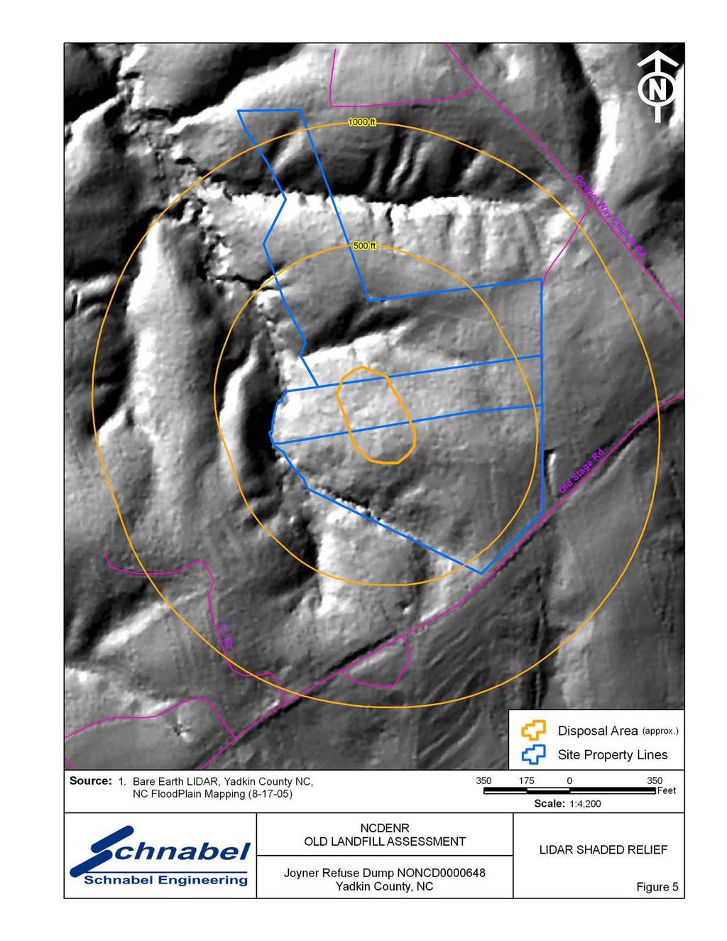
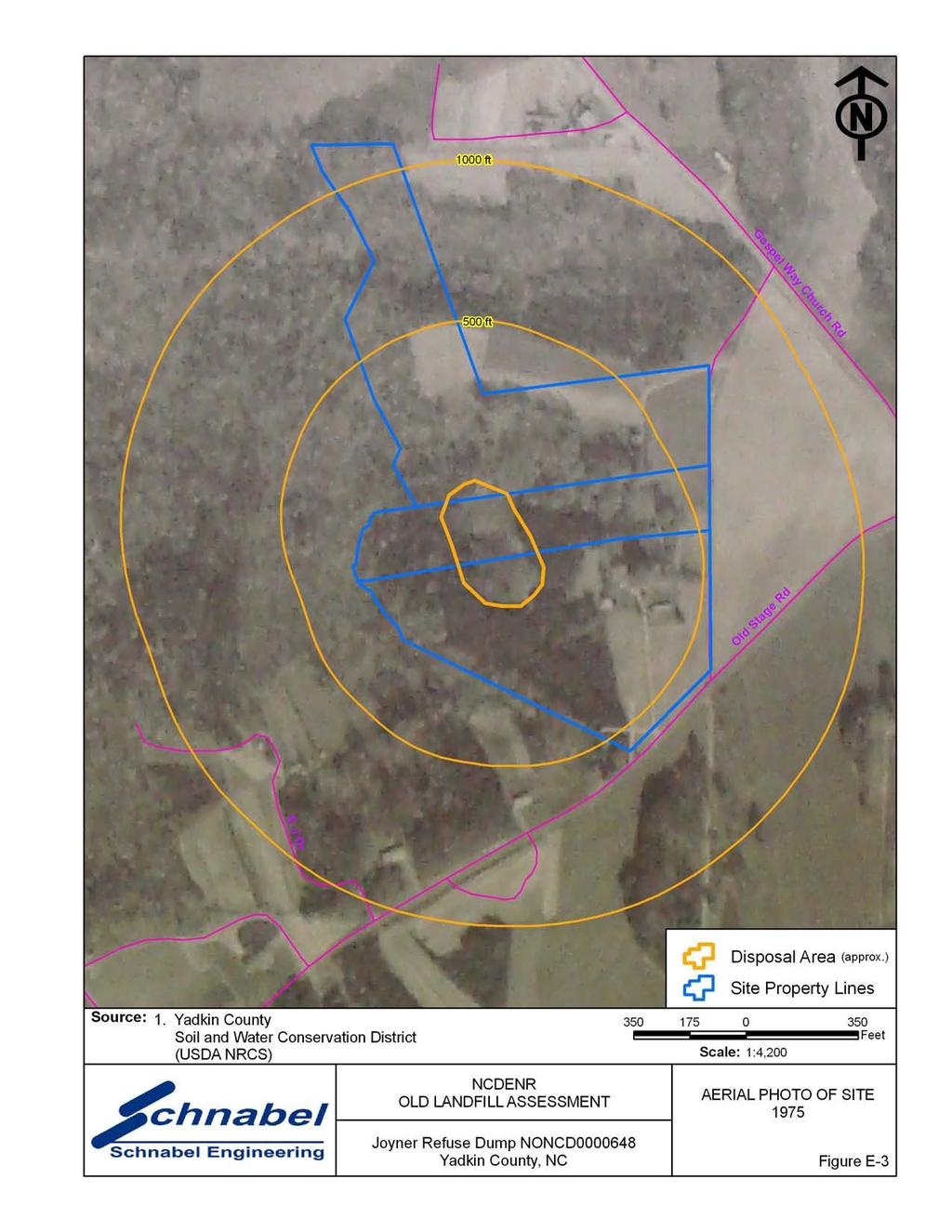
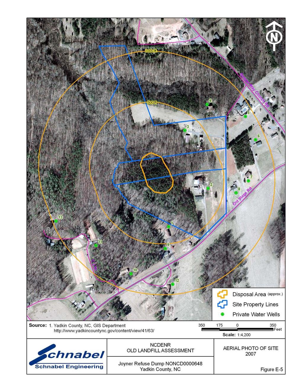
6 1.3 On-Site Water Supply Wells and Intakes Water supply wells were observed on the Site during the site visit. No water meters or fire hydrants were observed on the Site during the site visit. 1.4 Surface Water Features A spring is located on the western part of the Site. The spring was approximately two feet wide with isolated pools of water and a sandy bottom at the time of the site visit. 1.5 Disposal Area Access to the Disposal Area is from 1425 Old Stage Road and through a wooded entrance in the back yard (Photo 1). The Disposal Area occupies 1.9 acres based on the Disposal Area perimeter shown on Figures 1 through 3. The Disposal Area generally slopes to the north. A comparison of the topography from the 1963 USGS 7.5 minute topographic quadrangle map (20 foot contours) with the 2005 topographic map from NCDOT GIS Branch (10 foot contours) did not show observable differences in elevation or topographic patterns. Differences between elevations on the maps may reflect actual elevation changes or may be apparent differences due to the different map making methods. Differences in scale and methods of mapping are not sufficient to evaluate some changes in topography. GPS coordinates were taken of the Disposal Area perimeter. The approximate Disposal Area perimeter is illustrated on the figures and on aerial photographs in Appendix E. A table of GPS coordinates for the Site entrance and the Site perimeter is presented in Table 1. The Disposal Area perimeter location is approximate and is based on visual observations made at the time of the site visit and interpretation of aerial photographs. Figures 4 and 5 show LiDAR shaded relief superimposed on the Disposal Area. Joyner Refuse Dump NONCD
7 1.6 Disposal Area Conditions The southern part of the Disposal Area was covered with pine trees of one to two feet in diameter and briars. The northern part of the Disposal Area was covered with small trees, briars, and tall grass. Disposal material was exposed throughout the Disposal Area. The observed disposal material included old automobile parts, tires, white goods, plastic, glass, metal debris, and furniture. The observed Disposal Area was on multiple tax parcels, Parcel Numbers , , and The northern and eastern perimeters of the Disposal Area were visually evident and the southern and western perimeters of the Disposal Area were difficult to identify. The majority of the Disposal Area was on Parcel No The northern part of the Disposal Area extended onto Parcel No and the southern part of the Disposal Area extended onto Parcel No Hummocky topography was observed along the north central part of the Disposal Area. No notable erosion, depressions, offensive odors, stained or discolored soils, or slope failures were observed during the site visit. 1.7 Evidence of Human Activity There was no observed evidence of recent human activity on the Disposal Area at the time of the site visit. Residences are located on the eastern part of the Site. 1.8 Potential Landfill Gas Migration Pathways There were no visible or evident potential gas migration pathways such as stormwater drain systems, underground utilities, septic systems, or drain fields observed on the Disposal Area. The residences located about 75 feet to the east and 450 feet northeast of the Disposal Area are built on crawl spaces which may act as a potential gas migration pathway. Joyner Refuse Dump NONCD
8 1.9 Physical Barriers Site access is provided at 1425 Old Stage Road. Physical barriers were not observed along the property boundaries Other Pertinent Information Some history of the Site was obtained during conversations with persons familiar with the Site. The information obtained indicates that: Mr. Ronald Oakley, Property Owner, stated that the Site was used from the late 1960 s to Mr. Oakley stated that Mr. Carl Joyner owned the property during the disposal period. Mr. Oakley stated that he would like to build a home on the northeastern part of the Disposal Area. Mr. Oakley stated that Mr. Joyner ran a waste hauling service for the surrounding community and the Town of Yadkinville. Mr. Johnny Myers, area resident, stated that he remembers the Site being used for disposal purposes, and that Mr. Joyner allowed the City of Yadkinville to use the Site to place disposal material. Ms. Cheri Cranfill, Yadkin County Solid Waste Director, stated that she was aware of the Disposal Area, but was not sure who placed the disposal material on the Site. Mr. Perry Williams, Town of Yadkinville Public Works Department, stated that he had no knowledge of the Joyner Refuse Disposal site. Notes from conversations with people familiar with the site are included in Appendix C. The information obtained from these conversations has not been verified or confirmed. Joyner Refuse Dump NONCD
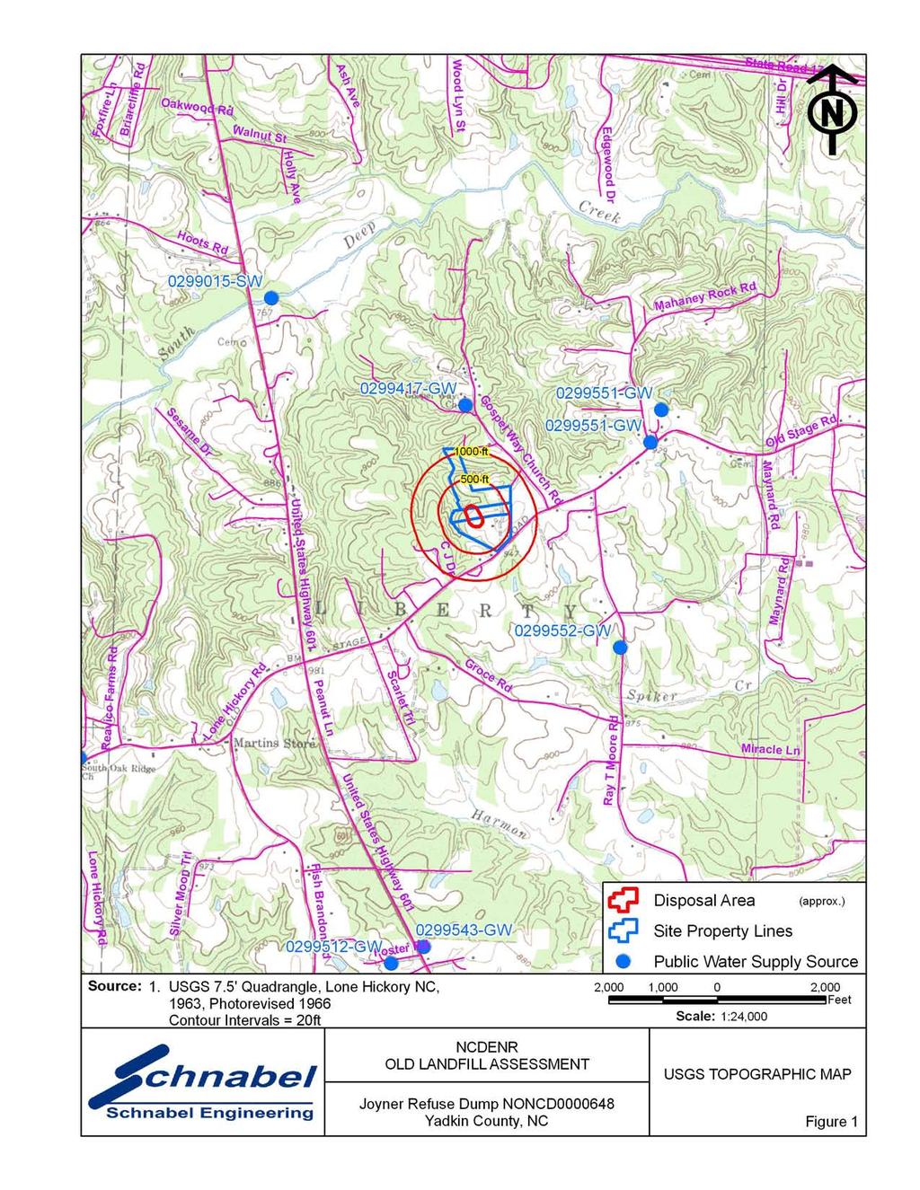
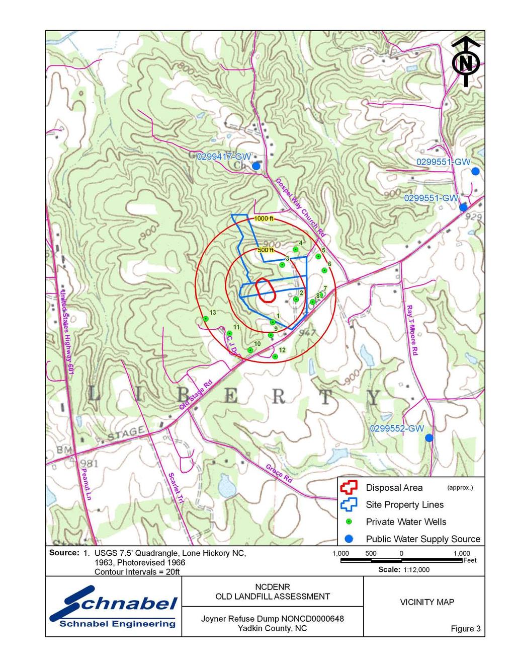
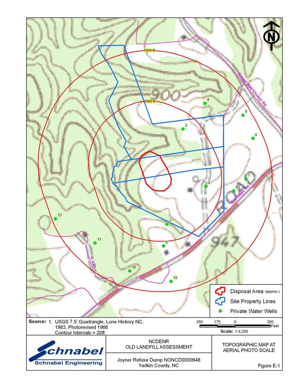
9 2.0 VICINITY CONDITIONS This section describes the observed general conditions in the vicinity of the Site, as defined as an area within 1,000 feet of the perimeter of the Disposal Area. Photographs illustrating vicinity conditions are included in Appendix D. 2.1 Structures Located on Adjacent Properties Structures described in this section are located on adjacent properties that have a shared property boundary with the Site. A house and garage are located on Tax Parcel to the south of the Site. Several houses are located to the northwest of the Site on multiple tax parcels on Old Stage Road. These structures are shown on Figure 2 and on aerial photographs in Figure E-1 through E-5 in Appendix E. 2.2 Water Supply Wells and Intakes Water supply wells were observed at residences along Old Stage Road within 1,000 feet of the perimeter of the Disposal Area. No water meters or fire hydrants were observed within 1,000 feet of the Site. According to Mr. Ronald Oakley, Property Owner, the area within 1,000 feet of the Disposal Area perimeter is not served by a public water supply. Locations and descriptions of wells within 1,000 feet of the Disposal Area are tabulated below and approximate locations are shown on the figures and aerial photographs in Appendix E. Joyner Refuse Dump NONCD
10 Wells 1 through 13 are in an apparent cross- or up-gradient direction from the Disposal Area. Well Number Approximate Distance from Disposal Area Perimeter (feet) WATER SUPPLY WELLS IN VICINITY Address Location Basis* 1 <500 Kathy Reavis, 1425 Old Stage Rd GPS Coordinates 2 <500 Ronald Oakley, 1433 Old Stage Rd Near Residence 3 <500 Celeste Dolinger, 1441 Old Stage Rd Near Residence to 1,000 Chris Disher, 1437 Old Stage Rd Near Residence to 1,000 Dinky Reavis, 2032 Gospel Way Church Near Residence to 1,000 Douglas Hefner, 1521 Old Stage Rd Near Residence to 1,000 Edwin Glass, 1509 Old Stage Rd Near Residence to 1,000 Daniel Spillman, 1501 Old Stage Rd Near Residence to 1,000 Amanda Reavis, 1417 Old Stage Rd Near Residence to 1,000 Edwin Parker, 1401 Old Stage Rd Near Residence to 1,000 Edwin Parker, 1401 Old Stage Rd Near Residence to 1,000 Jackie Henderson, 1400 Old Stage Rd Near Residence to 1,000 Terry Parker, 1353 Old Stage Rd Near Residence * The private water well locations shown on figures and aerial photographs in Appendix E are relatively accurate for wells located by GPS or visual observation. If not observed, water wells are assumed to be near residences not served by public water systems and these well locations are shown in an assumed location near the residences on figures and aerial photographs. Wells are shown as of 2008 and are plotted on all aerial photographs from all years. The nearest public water supply registered on the NCDENR Public Water Supply Section s database (as of January 2009) is a public water supply well ( GW) located to the north of the Site. This location is 1,500 feet cross-gradient of the Site at Gospel Way Baptist Church, 3353 Old Highway 421, Yadkinville, NC The location and permit number for this well are shown on Figure 1. A surface water intake is located to the north of the Disposal Area. This location is about 1/2 mile in an apparent down-gradient and upstream direction from the Site on South Deep Creek Joyner Refuse Dump NONCD
11 and is owned by the Town of Yadkinville, PO Box 816, Yadkinville, NC The location and permit number for this intake are shown on Figure Current Land Usage Property in the vicinity of the Site is primarily wooded, except for the area to the east which is residential. Land usage at the time of the site visit within 1,000 feet of the Disposal Area perimeter was: North: Wooded, apparent down-gradient direction from the Site. South: Wooded and residential, apparent up-gradient direction from the Site. East: Residential, apparent up-gradient direction from the Site. West: Wooded and residential, apparent cross-gradient direction from the Site. 2.4 Surface Water Features A spring is located on the western part of the Site. No other surface water features were observed during the site visit. Joyner Refuse Dump NONCD
12 3.0 AERIAL PHOTOGRAPHY REVIEW Aerial photographs were reviewed for the years 1966, 1975, 1993 and The reported years of operation of the Site were from the late 1960 s to Observations of each of the photographs are included in the following table. Copies of the aerial photographs are included in Appendix E. Some aerial photographs are reproductions of original aerial photographs and have some distortion; therefore, overlaid Disposal Area Boundaries and other features may vary from their actual locations. Hand drawn lines and notations on the photographs denote soils mapping information drawn on the original photographs by the USDA NRCS. Flight Year Observations Source 1966 The southern part of the Disposal Area is cleared, and bare ground is visible. Trees cover the northern part of the Disposal Area. Structures are apparent to the east and south of the 1 Disposal Area The Disposal Area is apparently covered with ground vegetation. The trees have been removed from the northern 1 part of the Disposal Area The Disposal Area is covered with trees and other vegetation The Disposal Area is covered with trees and other vegetation. The aerial photograph shows conditions representative of those observed during the visit. 2 Sources of aerial photos: 1) USDA NRCS office in Yadkinville, NC 2) Yadkin County GIS, This report was prepared specifically for the use of NCDENR Inactive Sites Branch under the Scope of Work defined in our contract dated October 26, Use of this document for other purposes or by other parties is at the sole risk of the user. Joyner Refuse Dump NONCD
13 TABLE
14 TABLE 1 Tabulated GPS Coordinates Point State Plane Coordinates (meters) Latitude (deg, min, sec) Longitude (deg, min, sec) Northing Easting N W Site Entrance P P P P P P P P Notes: 1) All points P-1 through P-8 are on observed Disposal Area perimeter. 2) Data obtained during site visit using WAAS enabled Thales Mobile Mapper. 3) All points in NAD83 datum.
15 FIGURES
16

17
18

19
20
21 FIELD RECONNAISSANCE SHEET
22
23
24
25
26
27
28 TAX RECORDS
29 Property Owner OAKLEY RONALD Administrative Data Parcel Ref No PIN Account No Tax District Land Use Code Land Use Desc Subdiv Code Subdiv Desc Neighborhood 0939 YADKINVILLE-FIRE DISTRICT Owner's Mailing Address 1425 OLD STAGE RD YADKINVILLE, NC Administrative Data Legal Desc PB6-145; X 00 Deed Bk/Pg 904 / 113 Plat Bk/Pg / Sales Information Grantor Sold Date Sold Amount $ 0 Property Location Address 1433 OLD STAGE RD Valuation Information Market Value $ 162,357 Market Value - Land and all permanent improvements, if any, effective January 1, 2005, date of County s most recent General Reappraisal Assessed Value $ 162,357 If Assessed Value not equal Market Value then subject parcel designated as a special class -agricultural, horticultural, or forestland and thereby eligible for taxation on basis of Present-Use and/or reduction from a formal appeal procedure Improvement Detail (1st Major Improvement on Subject Parcel) Year Built 1989 Built Use/Style Current Use MANUFACTURED HOUSING SNG * Percent Complete 100 Fnished Area (S/F) 1,568 ** Bathroom(s) 2 Full Bath(s) 0 Half Bath(s) ** Bedroom(s) 3 *** Multiple Improvements 001 * Note - As of January 1 * * Note - Bathroom(s), Bedroom(s), shown for description only * * * Note - If multiple improvements equal MLT then parcel includes additional major improvements Land Supplemental Map Acres 0 Tax District Note Present-Use Info Improvement Valuation (1st Major Improvement on Subject Parcel) * Improvement Market Value $ ** Improvement Assessed Value $ 75,087 75,087 * Note - Market Value effective Date equal January 1, 2001, date of County s most recent General Reappraisal ** Note - If Assessed Value not equal Market Value then variance resulting from formal appeal procedure Land Value Detail (Effective Date January 1, 2001, date of County s most recent General Reappraisal) Land Market Value (LMV) $ Land Present-Use Value (PUV) $ ** Land Total Assessed Value $ 87,270 87,270 87,270 ** Note: If PUV equal LMV then parcel has not qualified for present use program

30 200 ft Map created by Yadkin County & Northwest Piedmont COG. Yadkin County Assumes no legal responsibility for the data on this map. Please check with original source to verify data.
31 Property Owner DOLINGER CELESTE D Administrative Data Parcel Ref No PIN Account No Tax District Land Use Code Land Use Desc Subdiv Code Subdiv Desc Neighborhood 0939 YADKINVILLE-FIRE DISTRICT Owner's Mailing Address 1441 OLD STAGE RD YADKINVILLE, NC Administrative Data Legal Desc PB8-938; LOT#2 Deed Bk/Pg 262 / 504 Plat Bk/Pg / Sales Information Grantor Sold Date Sold Amount $ 0 Property Location Address 1441 OLD STAGE RD Valuation Information Market Value $ 130,309 Market Value - Land and all permanent improvements, if any, effective January 1, 2005, date of County s most recent General Reappraisal Assessed Value $ 130,309 If Assessed Value not equal Market Value then subject parcel designated as a special class -agricultural, horticultural, or forestland and thereby eligible for taxation on basis of Present-Use and/or reduction from a formal appeal procedure Improvement Detail (1st Major Improvement on Subject Parcel) Year Built 1994 Built Use/Style Current Use SINGLE FAMILY RESIDENTIAL * Percent Complete 100 Fnished Area (S/F) 1,782 ** Bathroom(s) 2 Full Bath(s) 0 Half Bath(s) ** Bedroom(s) 3 *** Multiple Improvements 001 * Note - As of January 1 * * Note - Bathroom(s), Bedroom(s), shown for description only * * * Note - If multiple improvements equal MLT then parcel includes additional major improvements Land Supplemental Map Acres 0 Tax District Note Present-Use Info Improvement Valuation (1st Major Improvement on Subject Parcel) * Improvement Market Value $ ** Improvement Assessed Value $ 53,241 53,241 * Note - Market Value effective Date equal January 1, 2001, date of County s most recent General Reappraisal ** Note - If Assessed Value not equal Market Value then variance resulting from formal appeal procedure Land Value Detail (Effective Date January 1, 2001, date of County s most recent General Reappraisal) Land Market Value (LMV) $ Land Present-Use Value (PUV) $ ** Land Total Assessed Value $ 77,068 77,068 77,068 ** Note: If PUV equal LMV then parcel has not qualified for present use program
32 500 ft Map created by Yadkin County & Northwest Piedmont COG. Yadkin County Assumes no legal responsibility for the data on this map. Please check with original source to verify data.
33 Property Owner DOLINGER CELESTE D Administrative Data Parcel Ref No PIN Account No Tax District Land Use Code Land Use Desc Subdiv Code Subdiv Desc Neighborhood 0939 YADKINVILLE-FIRE DISTRICT Owner's Mailing Address 1441 OLD STAGE RD YADKINVILLE, NC Administrative Data Legal Desc PB8-938; Deed Bk/Pg 621 / 544 Plat Bk/Pg / Sales Information Grantor Sold Date Sold Amount $ 27,500 Property Location Address OLD STAGE RD (OFF) Valuation Information Market Value $ 29,250 Market Value - Land and all permanent improvements, if any, effective January 1, 2005, date of County s most recent General Reappraisal Assessed Value $ 29,250 If Assessed Value not equal Market Value then subject parcel designated as a special class -agricultural, horticultural, or forestland and thereby eligible for taxation on basis of Present-Use and/or reduction from a formal appeal procedure Improvement Detail (1st Major Improvement on Subject Parcel) Year Built 0 Built Use/Style Current Use * Percent Complete 0 Fnished Area (S/F) 0 ** Bathroom(s) 0 Full Bath(s) 0 Half Bath(s) ** Bedroom(s) 0 *** Multiple Improvements 000 * Note - As of January 1 * * Note - Bathroom(s), Bedroom(s), shown for description only * * * Note - If multiple improvements equal MLT then parcel includes additional major improvements Land Supplemental Map Acres 0 Tax District Note Present-Use Info Improvement Valuation (1st Major Improvement on Subject Parcel) * Improvement Market Value $ ** Improvement Assessed Value $ 0 0 * Note - Market Value effective Date equal January 1, 2001, date of County s most recent General Reappraisal ** Note - If Assessed Value not equal Market Value then variance resulting from formal appeal procedure Land Value Detail (Effective Date January 1, 2001, date of County s most recent General Reappraisal) Land Market Value (LMV) $ Land Present-Use Value (PUV) $ ** Land Total Assessed Value $ 29,250 29,250 29,250 ** Note: If PUV equal LMV then parcel has not qualified for present use program

34 500 ft Map created by Yadkin County & Northwest Piedmont COG. Yadkin County Assumes no legal responsibility for the data on this map. Please check with original source to verify data.
35 RECORDS OF COMMUNICATION/SITE VISIT PERMISSION LETTER
36
37
38 RECORD OF CONVERSATION INTERVIEW SCHNABEL STAFF: Ben Bradley DATE/TIME: June 10, 2009 INTERVIEW WITH: Cheri Cranfill PHONE NO.: TITLE: Solid Waste Director FAX NO.: ORGANIZATION: Yadkin County ADDRESS: P.O. Box 1298, Yadkinville, NC PROJECT: NC DENR Old Unlined Landfill Assessments SITE NAME AND NCDENR ID NO.: Joyner Refuse Disposal, NONCD SUBJECT: Interview NOTES: On June 10, 2009, Ben Bradley interviewed Cheri Cranfill, Yadkin County Solid Waste Director, about her knowledge of Joyner Refuse Disposal. Ms. Cranfill stated that she was aware of the Disposal Area, but had no knowledge of who operated Joyner Refuse Disposal. G:\2006_projects\ _(NCDENR_Old_Unlined_Landfill)\Task_15_Yadkin_Co\0646-Joyner Refuse Dump\Report\Final\RecOfConv- CheriCranfill doc
39 RECORD OF CONVERSATION INTERVIEW SCHNABEL STAFF: Ben Bradley DATE/TIME: June 16, 2009 INTERVIEW WITH: Perry Williams PHONE NO.: TITLE: Public Works Director FAX NO.: ORGANIZATION: Town of Yadkinville ADDRESS: 213 Van Buren Street, Yadkinville, NC PROJECT: NC DENR Old Unlined Landfill Assessments SITE NAME AND NCDENR ID NO.: Joyner Refuse Disposal, NONCD SUBJECT: Interview NOTES: On June 16, 2009, Ben Bradley interviewed Perry Williams, Town of Yadkinville Public Works Director, about his knowledge of Joyner Refuse Disposal. Mr. Williams stated he had no knowledge of the Joyner Refuse Disposal site. G:\2006_projects\ _(NCDENR_Old_Unlined_Landfill)\Task_15_Yadkin_Co\0646-Joyner Refuse Dump\Report\Final\RecOfConv- PerryWilliams doc
40 RECORD OF CONVERSATION INTERVIEW SCHNABEL STAFF: Ben Bradley DATE/TIME: June 20, 2009 INTERVIEW WITH: Johnny Myers PHONE NO.: TITLE: Area Resident FAX NO.: ORGANIZATION: ADDRESS: 2121 Ray T. Moore Road, Yadkinville, NC PROJECT: NC DENR Old Unlined Landfill Assessments SITE NAME AND NCDENR ID NO.: Joyner Refuse Disposal, NONCD SUBJECT: Interview NOTES: On June 20, 2009, Ben Bradley interviewed Johnny Myers, area resident, about his knowledge of Joyner Refuse Disposal. Mr. Myers stated that he remembers the Site being used for disposal purposes, and that Mr. Carl Joyner allowed the City of Yadkinville to use the Site to place disposal material. G:\2006_projects\ _(NCDENR_Old_Unlined_Landfill)\Task_15_Yadkin_Co\0646-Joyner Refuse Dump\Report\Final\RecOfConv- JohnnyMyers doc
41 RECORD OF CONVERSATION SITE ACCESS PERMISSION-INTERVIEW SCHNABEL STAFF: Ben Bradley DATE/TIME: July 21, 2009 INTERVIEW WITH: Ronald Oakley PHONE NO.: TITLE: Property Owner FAX NO.: ORGANIZATION: ADDRESS: 1425 Old Stage Road, Yadkinville, NC PROJECT: NC DENR Old Unlined Landfill Assessments SITE NAME AND NCDENR ID NO.: Joyner Refuse Disposal, NONCD SUBJECT: Site Access Permission-Interview NOTES: On July 21, 2009, Ben Bradley interviewed Ronald Oakley, Property Owner, about his knowledge of Joyner Refuse Disposal. Mr. Oakley stated that the Site was used from the late 1960 s to Mr. Oakley stated that Mr. Carl Joyner owned the property during the disposal period. Mr. Oakley stated that Mr. Joyner ran a waste hauling service for the surrounding community and the Town of Yadkinville. Mr. Oakley stated that he would like to build a home on the northeastern part of the Disposal Area. Mr. Oakley stated that a residence is located on the eastern part of the Site which is occupied by his sister-in-law. Mr. Oakley stated that the Disposal Area is not used. G:\2006_projects\ _(NCDENR_Old_Unlined_Landfill)\Task_15_Yadkin_Co\0646-Joyner Refuse Dump\Report\Final\RecOfConv- RonaldOakley doc
42 SITE PHOTOGRAPHS


43 PHOTOGRAPH No.: 1 Photo Taken: LOCATION: Joyner Refuse Dump Site entrance from 1425 Old Stage Road, Yadkinville, NC COMMENTS: Photo taken facing toward the northeast. PHOTOGRAPH No.: 2 Photo Taken: LOCATION: Southeastern part of Disposal Area. COMMENTS: Exposed disposal material including rusted tin cans, furniture, and metal debris. Joyner Refuse Dump, NONCD


44 PHOTOGRAPH No.: 3 Photo Taken: LOCATION: Central part of Disposal Area. COMMENTS: Exposed disposal material including rusted tin cans, glass, plastic, and auto parts. PHOTOGRAPH No.: 4 Photo Taken: LOCATION: Northern part of Disposal Area. COMMENTS: Hummocky topography with areas of exposed disposal material. Joyner Refuse Dump, NONCD


45 PHOTOGRAPH No.: 5 Photo Taken: LOCATION: Northern part of Disposal Area. COMMENTS: Old automobile and engine. PHOTOGRAPH No.: 6 Photo Taken: LOCATION: Northern part of Disposal Area. COMMENTS: Small trees, bushes, briars, and exposed disposal material. Joyner Refuse Dump, NONCD


46 PHOTOGRAPH No.: 7 Photo Taken: LOCATION: Northern Disposal Area boundary. COMMENTS: Photo taken facing toward the south. PHOTOGRAPH No.: 8 Photo Taken: LOCATION: Northeastern part of Disposal Area. COMMENTS: Exposed disposal material. Joyner Refuse Dump, NONCD


47 PHOTOGRAPH No.: 9 Photo Taken: LOCATION: Eastern Disposal Area boundary. COMMENTS: Exposed white goods and tires. PHOTOGRAPH No.: 10 Photo Taken: LOCATION: Western part of Site. COMMENTS: Spring with isolated pools of clear water at time of site visit. Joyner Refuse Dump, NONCD

48 PHOTOGRAPH No.: 11 Photo Taken: LOCATION: Southern part of Disposal Area. COMMENTS: Exposed disposal material in tree roots. Joyner Refuse Dump, NONCD
49 AERIAL PHOTOGRAPHS
50

51
52
53
54
Phase I Environmental Site Assessment Update Memorandum Vacant Property 1585 Santa Clara Avenue Santa Ana, California 92507
 March 1, 2011 Mr. Vincent C. Fregoso, AICP City of Santa Ana 20 Civic Center Plaza Santa Ana, CA 92702 Re: Phase I Environmental Site Assessment Update Memorandum Vacant Property 1585 Santa Clara Avenue
Environmental Audit Standards
 Environmental Audit Standards Lender requires an acceptable Phase I Environmental Audit Report, directed to Lender and historical in nature, which is to be prepared in accordance with the standards set
SECTION SITE SURVEYS
 PART 1 - GENERAL 1.1 DESCRIPTION SECTION 02 21 00 SPEC WRITER NOTES: 1. Use this section only for NCA projects. 2. Delete between //---// if not applicable to project. Also delete any other item or paragraph
1976 Fargo, ND City Directory - R.L. Polk & Co.
 1986 Fargo, ND City Directory - R.L. Polk & Co. 1981 Fargo, ND City Directory - R.L. Polk & Co. 1976 Fargo, ND City Directory - R.L. Polk & Co. 1971 Fargo, ND Directory - R.L. Polk & Co. 1971 Fargo, ND
PHASE I ENVIRONMENTAL SITE ASSESSMENT
 PHASE I ENVIRONMENTAL SITE ASSESSMENT ACME Gas 55 Garden Street Columbus, Ohio, 45123 Prepared for ACME Oil & Gas Ltd. Prepared by GAEA Environmental Services 87 Garden Street Whitby, Ontario L1N 9E7 November
A.3. ARTICLE 7 PLAN REQUIREMENTS FOR MINOR SUBDIVISION AND/OR LAND DEVELOPMENT
 700. 701.A.3. ARTICLE 7 PLAN REQUIREMENTS FOR MINOR SUBDIVISION AND/OR LAND DEVELOPMENT SECTION 700 PURPOSE The purpose of this Article is to set forth a streamlined set of Plan Requirements for minor
APPLICATION. Telephone Fax Address. Telephone Fax Address FOR MARTIN COUNTY USE ONLY
 APPLICATION PRESERVE AREA MANAGEMENT PLAN/ ABBREVIATED PRESERVE AREA MANAGEMENT PLAN Growth Management Department Environmental Division PART 1: Applicant Information A. Land Owner(s) Name Title and Company
Purpose: Regulations:
 Administrative Procedures for the Designation and Refinement Of Chesapeake Bay Preservation Area Boundaries Guidance on the Chesapeake Bay Preservation Area Designation and Management Regulations September,
10. GENERAL PLAN 11. ZONING 12. LAND USE 13. ASSESSOR S PARCEL NUMBER 18. PROPOSED ZONING 19. PROPOSED LAND USE 20. NO. UNITS 21.
 STAFF USE ONLY ACCEPTED BY Application for Discretionary Permit Development Services Department / Planning Division (760) 435-3520 Oceanside Civic Center 300 North Coast Highway Oceanside, California 92054-2885
New Residential Construction Off-Site Conditions Disclosure 5:36-3 NEW RESIDENTIAL CONSTRUCTION OFF-SITE CONDITIONS DISCLOSURE GENERAL PROVISIONS
 5:36-3 NEW RESIDENTIAL CONSTRUCTION OFF-SITE CONDITIONS DISCLOSURE GENERAL PROVISIONS 5:36-3.1 Purposes (a) The purposes of this chapter are as follows: 1. To prescribe the form and manner of submission
Moore Township Planning Commission 2491 Community Drive, Bath, Pennsylvania Telephone: FAX: Rev:12/23/2013
 2491 Community Drive, Bath, Pennsylvania Telephone: 610-759-9449 FAX: 610-759-9448 Rev:12/23/2013 APPLICATION FORM FOR A SITE PLAN PER MOORE TOWNSHIP ZONING ORDINANCE SECTION 200-58.1 NORTHAMPTON COUNTY,
EXTRA TERRITORIAL ZONING AUTHORITY CASE ANALYSIS
 DOÑA ANA COUNTY CASE # V09-007 COMMUNITY PLANNING AND ECONOMIC DEVELOPMENT DEPARTMENT Building Planning GIS 845 North Motel Boulevard Las Cruces, New Mexico 88007 (575) 647-7350 Fax: (575) 525-6131 Toll
PROJECT ADDRESS ASSESSOR S PARCEL NUMBER G.P. LAND USE DESIGNATION ZONING DISTRICT FLOOD HAZARD ZONE SITE ACREAGE AIRPORT SAFETY ZONE?
 TYPE OR PRINT CLEARLY Submit Completed Applications to: City of Corning Planning Dept. 794 Third Street Corning, CA 96021 PROJECT ADDRESS ASSESSOR S PARCEL NUMBER G.P. LAND USE DESIGNATION ZONING DISTRICT
Boise County Planning & Zoning Department P.O Box 1300 Idaho City, Idaho Phone (208) Fax (208)
 Fax (208)") Boise County Planning & Zoning Department P.O Box 1300 Idaho City, Idaho 83631 Phone (208) 392-2293 Fax (208) 392-2259 Land Development Application Subdivision Ordinance #2006-2 Proposed Subdivision Name:
Boise County Planning & Zoning Department P.O Box 1300 Idaho City, Idaho 83631 Phone (208) 392-2293 Fax (208) 392-2259 Land Development Application Subdivision Ordinance #2006-2 Proposed Subdivision Name:
DRAFT - Subject to Change. Cathedral Building 212 North Ash Street Crookston, Minnesota. Prepared For. Project FA June 29, 2011
 DRAFT Phase I Environmental Site Assessment Cathedral Building 212 North Ash Street Crookston, Minnesota Prepared For Braun Intertec Corporation Ms. Kay Hegge Prairie Skyline Foundation 27048 310th Street
October 29, 2013 Florida Brownfields Association Conference, Orlando
 Site Inventories October 29, 2013 Florida Brownfields Association Conference, Orlando Andrew M. Lawn, M.S., P.G. Principal Hydrogeologist Holden Heights Areas HSW & Orange County Environmental Protection
UPPER MOUNT BETHEL TOWNSHIP NORTHAMPTON COUNTY, PENNSYLVANIA
 UPPER MOUNT BETHEL TOWNSHIP NORTHAMPTON COUNTY, PENNSYLVANIA JOINDER DEED / LOT CONSOLIDATION TOWNSHIP REVIEW PROCESS When accepting proposed Joinder Deeds / Lot Consolidations, review the Joinder Deed
MINOR SUBDIVISION APPLICATION
 MINOR SUBDIVISION APPLICATION Complete with required information (write "n/a" if information is not applicable to proposal). Title of Plat Has any other plat been recorded for this site? ( ) Yes ( ) No
APPLICATION FOR SUBDIVISION APPROVAL OF A SKETCH PLAN with checklist
 Prior to filing any application for SUBDIVISION approval, the applicant shall request in writing that the zoning administrator schedule a pre-submission conference. APPLICATION TO THE PLANNING BOARD TOWN
Department of Planning & Development Services
 Department of Planning & Development Services S T A F F R E P O R T February 9, 2015 CASE NO: PROJECT: EXECUTIVE SUMMARY: ZA14-154 Plat Revision for Lots 25R-1A, 25R-1B and 25R-1C, Block 1, Woodland Heights
VANCE COUNTY BOARD OF ADJUSTMENTS
 VANCE COUNTY BOARD OF ADJUSTMENTS The Vance County Board of Adjustments met at a regular and duly advertised meeting on October 15, 2015 at 4:00 p.m. in the Commissioners Meeting Room of the Vance County
PLANNING BOARD CITY OF CONCORD, NH MINOR SUBDIVISION CHECKLIST
 PLANNING BOARD CITY OF CONCORD, NH MINOR SUBDIVISION CHECKLIST Summary This checklist is intended to assist applicants and design professionals in the preparation of minor subdivision applications for
Initial Subdivision Applications Shall Include the Following:
 Initial Subdivision Applications Shall Include the Following: 1) Subdivision Application Form: completely filled out (12 copies) 2) Plat: The Plat must adhere to the requirements set forth in the Town
LINCOLN COUNTY PLANNING & INSPECTIONS DEPARTMENT
 LINCOLN COUNTY PLANNING & INSPECTIONS DEPARTMENT 30 NORTH ACADEMY STREET, SUITE A, LINCOLNTON, NORTH CAROLINA 809 704-736-8440 OFFICE 704-736-8434 INSPECTION REQUEST LINE 704-73-900 FAX To: Board of Commissioners
PHASE I ENVIRONMENTAL SITE ASSESSMENT REPORT 3.3-ACRE ECKENRODE PROPERTY WARWICK TOWNSHIP, TUSCARAWAS COUNTY, OHIO. Prepared for: OHIOLAND, LLC
 PHASE I ENVIRONMENTAL SITE ASSESSMENT REPORT 3.3-ACRE ECKENRODE PROPERTY WARWICK TOWNSHIP, TUSCARAWAS COUNTY, OHIO Prepared for: OHIOLAND, LLC Prepared by: CIVIL & ENVIRONMENTAL CONSULTANTS, INC. COLUMBUS,
Larimer County Planning Dept. Procedural Guide for 1041 PERMITS
 - Larimer County Planning Dept. Procedural Guide for 1041 PERMITS PLEASE NOTE: A PRE-APPLICATION CONFERENCE IS REQUIRED PRIOR TO SUBMITTING THIS APPLICATION. PURPOSE: State Statutes allow local governments
Volume Three Appendix 7. Scheme Plan and other subdivision requirements
 Volume Three Appendix 7 Appendix 7 Scheme Plan and other subdivision requirements Any application for subdivision consent must be accompanied by a Scheme Plan that contains the information set out in this
Jurisdictional Determination Request
 This form is intended for use by anyone requesting a jurisdictional determination (JD) from the U.S. Army Corps of Engineers, Wilmington District (Corps). Please include all supporting information, as
BOA David Hollerich Centerline Setback Variance 09/05/2012
 BOA 10-12 David Hollerich Centerline Setback Variance 09/05/2012 Request for variance to reduce the required centerline setback from Granite Circle of 65 feet to 40 feet for a proposed farm equipment building
SUBDIVISION AND LAND DEVELOPMENT. 185 Attachment 20
 185 Attachment 20 APPENDIX S Plat No. Date of Submission Twp. Fee $ Dauphin Co. Fee $ TOWNSHIP OF DERRY SUBDIVISION OR LAND DEVELOPMENT PLAN SUBMISSION APPLICATION This block for Twp. use only 1. Title
MAJOR SUBDIVISION PRELIMINARY PLAT CHECKLIST
 TOWNSHIP OF EGG HARBOR PLANNING BOARD/ZONING BOARD OF ADJUSTMENT 3515 BARGAINTOWN ROAD EGG HARBOR TOWNSHIP, NJ 08234 MAJOR SUBDIVISION PRELIMINARY PLAT CHECKLIST The following checklist is designed to
PERMITS, ENCROACHMENTS AND EASEMENTS
 CHAPTER SEVEN PERMITS, ENCROACHMENTS AND EASEMENTS I. REQUIRED PERMITS FOR CONSTRUCTION All water and sewer system extension plans and specifications must be approved by PWC and all necessary permits,
CARROLL COUNTY BUREAU OF DEVELOPMENT REVIEW OFF-CONVEYANCE SUBMITTAL CHECKLIST AND REVIEW FEE SHEET NOTICE: INCOMPLETE SUBMITTALS WILL BE RETURNED
 CARROLL COUNTY BUREAU OF DEVELOPMENT REVIEW OFF-CONVEYANCE SUBMITTAL CHECKLIST AND REVIEW FEE SHEET An off-conveyance submittal shall include all items as specified in Section 103-7 of the Code of Public
FOR SALE 605 Industry Ave DISTRIBUTION WAREHOUSE FACILITY Asking $395,000
 FOR SALE 605 Industry Ave DISTRIBUTION WAREHOUSE FACILITY Asking $395,000 For Additional Information and To View the Property Please Contact Sandy Hoff - Office Phone 218-722-5556 shoff@fisalter.com AREA
Watkinsville First Baptist Church Building and Parking Masterplan Norton Road & Simonton Bridge Road Oconee County Georgia
 Watkinsville First Baptist Church Building and Parking Masterplan Norton Road & Simonton Bridge Road Oconee County Georgia Special Use Approval A-1 CUP to A-1 with Special Use Approval Total Site Area
Appendix F - Earth Materials Extraction, Processing and Site Reclamation
 Appendix F - Earth Materials Extraction, Processing and Site Reclamation Intent It is the purpose of this Article to establish regulations and standards for surface mining operations and to provide for
MEMORANDUM. DATE: April 6, 2017 TO: Zoning Hearing Board Jackie and Jake Collas. FROM: John R. Weller, AICP, Zoning Officer
 MEMORANDUM DATE: April 6, 2017 TO: Zoning Hearing Board Jackie and Jake Collas FROM: John R. Weller, AICP, Zoning Officer SUBJECT: Zoning Hearing Board appeal of Jackie and Jake Collas Relief requested
FINAL REVIEW: Seigfreid Conservation Easement non-ownership interest Date: October 22, 2015 Staff Assigned: Castino
 DEPARTMENT OF NATURAL RESOURCES Parks & Visitor Services Open Lands Weed Management & Forestry 1800 South County Road 31 Loveland, CO 80537 (970) 679-4570/ (970) 679-4574 FAX www.larimer.org/naturalresources
Instructions to the Applicant
 CONDITIONAL USE PERMIT APPLICATION Lake of the Woods County Land and Water Planning Office 206 8 th Avenue Southeast, Suite #290 Baudette MN 56623-2867 www.co.lake-of-the-woods.mn.us Phone: (218) 634-1945
Madison County Health Department Environmental Health 493 Medical Park Drive, Marshall, NC Telephone: Fax:
 Madison County Health Department Environmental Health 493 Medical Park Drive, Marshall, NC. 28753 Telephone: 828-649-9598 Fax: 828-649-9370 Construction Authorization Permit In order to process your septic
CHAPTER 26 PLANNING AND ZONING ARTICLE VII. MOBILE HOMES AND RECREATIONAL VEHICLE (RV) PARKS. Recreational Vehicle (RV) Park Development Standards
 PARKS. Recreational Vehicle (RV) Park Development Standards") CHAPTER 26 PLANNING AND ZONING ARTICLE VII. MOBILE HOMES AND RECREATIONAL VEHICLE (RV) PARKS. Section 26-VII-1. Section 26-VII-2. Section 26-VII-3. Section 26-VII-4. Section 26-VII-5. Purpose Permitted
CHAPTER 26 PLANNING AND ZONING ARTICLE VII. MOBILE HOMES AND RECREATIONAL VEHICLE (RV) PARKS. Section 26-VII-1. Section 26-VII-2. Section 26-VII-3. Section 26-VII-4. Section 26-VII-5. Purpose Permitted
SISKIYOU COUNTY PLANNING COMMISSION STAFF REPORT March 21, 2018
 SISKIYOU COUNTY PLANNING COMMISSION STAFF REPORT March 21, 2018 NEW BUSINESS - AGENDA ITEM No. 2: JOANNE RICHARDSON TENTATIVE PARCEL MAP (TPM-17-04) APPLICANT: PROPERTY OWNER: PROJECT SUMMARY: GENERAL
Legal Description Part of the Western Half of the Eastern Half of the Northwest Quarter of Section 30, Le Ray Township
 Owner and Applicant s 20448 State Highway 83 Mankato, MN 56001 Request and Location Request for review and approval of a Conditional Use Permit to allow an Elder Care Residential Unit to be constructed
COMMUNITY MEETING EXHIBITS
 COMMUNITY MEETING EXHIBITS EXHIBIT 1 : Meeting Agenda EXHIBIT 2 : Presentation Posters EXHIBIT 3 : Attendance Sign-In Sheet EXHIBIT 4 : Letters to Property Owners EXHIBIT 5 : Photos of Meeting EXHIBIT
APPLICATION PROCESSING STEPS STEP 1 CHECK WITH STAFF
 APPLICATION PROCESSING STEPS STEP 1 CHECK WITH STAFF - Development Services Staff will explain the requirements and procedures to you. However, before filing an application with the Community Development
TENTATIVE PARCEL MAP APPLICATION GUIDE TENTATIVE PARCEL MAP APPLICATION REQUIREMENTS
 TENTATIVE PARCEL MAP APPLICATION GUIDE SISKIYOU COUNTY PLANNING DIVISION 806 South Main Street, Yreka CA 96097 Phone: (530) 841-2100 / Fax: (530) 841-4076 TENTATIVE PARCEL MAP APPLICATION REQUIREMENTS
APPLICATION FOR SUBDIVISION APPROVAL Summary of Application Review & Approval Process and Application Form April 1, 2009
 Land Planning Branch, (K-320LP) Phone 667-8877 Fax 393-6340 APPLICATION FOR SUBDIVISION APPROVAL Summary of Application Review & Approval Process and Application Form April 1, 2009 THE SUBDIVISION APPLICATION,
PRELMINARY PLAT CHECKLIST
 PRELMINARY PLAT CHECKLIST A. All preliminary plat submitted for approval shall be prepared by a Registered Professional Land Surveyor. B. Preliminary plats must be drawn to a scale of XXX with such accuracy
Report to the Plan Commission August 20, 2012
 Report to the Plan Commission Legistar I.D. #27376 5692-5696 Monona Drive Conditional Use Requested Action: Approval of a conditional use for an outdoor eating area for a restaurant and an accessory parking
REPORT ON SUBDIVISION WITHIN THE AGRICULTURAL LAND RESERVE (ALR) FILE NO. 075/2015
 FILE NO. 075/2015") Peace River Regional District DEVELOPMENT SERVICES REPORT ON SUBDIVISION WITHIN THE AGRICULTURAL LAND RESERVE (ALR) FILE NO. 075/2015 OWNER: Audrey LeClere DATE: April 27, 2015 AREA: Electoral Area B LEGAL:
Peace River Regional District DEVELOPMENT SERVICES REPORT ON SUBDIVISION WITHIN THE AGRICULTURAL LAND RESERVE (ALR) FILE NO. 075/2015 OWNER: Audrey LeClere DATE: April 27, 2015 AREA: Electoral Area B LEGAL:
204 Minor Subdivision & Large Lot Division
 204 Minor Subdivision & Large Lot Division 204.01 Purpose and Intent 204.05 General Procedures 204.10 Large Lot Division 204.02 Comprehensive Land Use 204.06 Submittal Requirements Plan Policies 204.07
Town of Southern Pines Planning Board Meeting, Thursday, July 24 19, 2014, 7:00 PM, Douglass Community Center, 1185 West Pennsylvania Avenue
 Town of Southern Pines Planning Board Meeting, Thursday, July 24 19, 2014, 7:00 PM, Douglass Community Center, 1185 West Pennsylvania Avenue I Call to Order II Approval of the Minutes June 19, 2014 III
Instructions for Maps to Accompany Proof of Appropriation and Beneficial Use of Ground Water
 Instructions for Maps to Accompany Proof of Appropriation and Beneficial Use of Ground Water Part II of the Proof of Appropriation (Form U.W. 8) All maps to accompany proof of appropriation and beneficial
 Conservation and Development Plan Muddy Acres Subdivision March 21, 2018 General This narrative will detail the Conservation and Development Plan for Muddy Acres Subdivision located on Tulls Creek Road
SITE DEVELOPMENT PLAN REQUIREMENTS CHECKLIST
 SITE DEVELOPMENT PLAN REQUIREMENTS CHECKLIST Completed DRC Application for Review Required for Application Process DRC Processing Fee 1 Commercial $2,500.00 Fire Department Review Fee 150.00 Total $2,650.00
PHASE I ENVIRONMENTAL SITE ASSESSMENT
 PHASE I ENVIRONMENTAL SITE ASSESSMENT ST. MALACHY PROPERTY, BROWNSBURG HENDRICKS COUNTY, INDIANA Terra Project No. 13-013 Environmental Audit Report Privileged Document PREPARED FOR: Town of Brownsburg
Plats and subdivisions; mapping requirements. (a) Size Requirements. All land plats presented to the register of deeds for recording in the
 Size Requirements. All land plats presented to the register of deeds for recording in the") 47-30. Plats and subdivisions; mapping requirements. (a) Size Requirements. All land plats presented to the register of deeds for recording in the registry of a county in North Carolina after September
47-30. Plats and subdivisions; mapping requirements. (a) Size Requirements. All land plats presented to the register of deeds for recording in the registry of a county in North Carolina after September
VAR17-03 St. Charles County Board of Zoning Adjustment
 VAR17-03 St. Charles County Board of Zoning Adjustment 79 FARM VIEW LN - VARIANCE REQUEST Application: Owner: Applicant: Variance Requested: Zoning: Area: Location: Council District: 1 Account No.: 676770A000
APPENDIX E FORMS INDEX OF ZONING FORMS
 APPENDIX E FORMS The zoning forms to follow in this appendix are used by Morrow County Zoning on behalf of their zoning resolution. There are two checklist sheets at the front of the forms that will assist
City of Midland Application for Site Plan Review
 City of Midland Application for Site Plan Review Submission Date: Property Owner: Mailing Address: Phone number: ( ) Cell phone: ( ) Email address: Fax: ( ) Owner s Signature: Applicant Name (if not owner):
APPLICATION REVIEW CHECKLISTS
 APPLICATION REVIEW CHECKLISTS The following must be submitted with and are part of each application. No application is complete until all required documentation has been submitted to the Community Development
COUNTY OF LINCOLN, NORTH CAROLINA
 COUNTY OF LINCOLN, NORTH CAROLINA 302 NORTH ACADEMY STREET, SUITE A, LINCOLNTON, NORTH CAROLINA 28092 PLANNING AND INSPECTIONS DEPARTMENT 704-736-8440 OFFICE 704-732-9010 FAX To: Alex Patton, Board of
Historic Structures Report for U-2581B/R-2910 Alamance and Guilford Counties, NC May 2013
 91. NCDOT Survey #14, Foster House (GF-8176), 7216 Burlington Road, Guilford County, garage, north façade, looking south.... 95 92. NCDOT Survey #16, Gaither House (GF-8178), 7206 Burlington Road, Guilford
Waseca County Planning and Zoning Office
 Waseca County Planning and Zoning Office 300 North State Street Waseca, Minnesota 56093 Phone: 507-835-0650 Fax: 507-837-5310 Form no. PZ 081009 Web Site: www.co.waseca.mn.us FEES: 1) CUP FEE- $400.00
Septic Tank / Drainfield / Holding Tank Permit Application
 Septic Tank / Drainfield / Holding Tank Permit Application : Permit # : PID #: Septic Fee $: Soil Verification Fee $: Investigative/Other Fee $: PLEASE PRINT CLEARLY Total Permit Fee $: The Applicant Is:
AMENDED AGENDA BLUFFDALE CITY BOARD OF ADJUSTMENT. January 24, 2017
 AMENDED AGENDA BLUFFDALE CITY BOARD OF ADJUSTMENT January 24, 2017 Notice is hereby given that the Bluffdale City Board of Adjustment will hold a public meeting Tuesday, January 24, 2017, at the Bluffdale
E L M E R B O R O U G H L A N D U S E B O A R D APPLICATION COVER SHEET (to be completed for all applications and appeals)
") E L M E R B O R O U G H L A N D U S E B O A R D APPLICATION COVER SHEET (to be completed for all applications and appeals) 1. Name(s): 2. Address: 3. Telephone Number(s): 4. E-mail: 5. Owner Name(s) (if
E L M E R B O R O U G H L A N D U S E B O A R D APPLICATION COVER SHEET (to be completed for all applications and appeals) 1. Name(s): 2. Address: 3. Telephone Number(s): 4. E-mail: 5. Owner Name(s) (if
FINAL SUBDIVISION AND LAND DEVELOPMENT PLAN CHECKLIST. Plan Name. Applicant's Name:
 TOWNSHIP OF UPPER ST. CLAIR FINAL SUBDIVISION AND LAND DEVELOPMENT PLAN CHECKLIST Date Filed Plan Name PLC Applicant's Name: Phone Filing Date for Final Application Final Plat 114.22. FINAL APPLICATION
Visual On land Trash Assessment Protocol for Stormwater
 Visual On land Trash Assessment Protocol for Stormwater Version 1.0 DRAFT Prepared for: Santa Clara Valley Urban Runoff Pollution Prevention Program Alameda Countywide Clean Water Program Contra Costa
The following information is for use by the Lincoln County Planning Board at their meeting/public hearing on December 4, 2017.
 LINCOLN COUNTY PLANNING & INSPECTIONS DEPARTMENT 302 NORTH ACADEMY STREET, SUITE A, LINCOLNTON, NORTH CAROLINA 28092 704-736-8440 OFFICE 704-736-8434 INSPECTION REQUEST LINE 704-732-9010 FAX To: Planning
APPLICATION for MINOR SUBDIVISION REVIEW for CONCEPT and FINAL PLAT within COALVILLE CITY. Project Name: Project Address or Area: Name of Owner:
 APPLICATION for MINOR SUBDIVISION REVIEW for CONCEPT and FINAL PLAT within COALVILLE CITY For Office Use Only: Application #: Application Date: PC Approval Date: CC Approval Date: Community Development
REGULAR FINAL PLAT SUBDIVISION APPLICATION
 REGULAR FINAL PLAT SUBDIVISION APPLICATION Name of Subdivision (Subdivision Name must be approved by at 856-6216) ( )Cluster Subdivision ( )Lot-by-Lot Subdivision ( )Open Space Subdivision Name of Subdivision
APPLICATION PROCEDURE
 ANTRIM PLANNING BOARD P. O. Box 517 Antrim, New Hampshire 03440 Phone: 603-588-6785 FAX: 603-588-2969 APPLICATION FORM AND CHECKLIST FOR MINOR OR MAJOR SITE PLAN REVIEW File Date Received By APPLICATION
Planning Department Permit Application
 Inyo County Planning Department 168 North Edwards Street Post Office Drawer L Independence, California 93526 Phone: (760) 878-0263 FAX: (760) 872-2712 E-Mail: inyoplanning@ inyocounty.us Planning Department
ALAMANCE COUNTY ENVIRONMENTAL HEALTH APPLICATION FOR SERVICES SERVICES REQUESTED
 Improvement Permit (Site Evaluation) (complete pages 1-6) Construction Authorization (Improvement Permit needed prior to this) (complete pages 1-6) Existing Septic System Inspection (for manufactured home
ARTICLE FIVE FINAL DRAFT
 ARTICLE FIVE 021218 FINAL DRAFT Sec. 503.6 Open Space Preservation Option Open Space Preservation Option Open Space Preservation developments may be approved in the AR, R-1, R-2 and R-3 zoning districts,
Our Staff Member are committed to helping you during this process.
 Sandbridge General Permit Sand Management Sandbridge General Permit Application Instructions The Virginia Beach Wetlands Board adopted a General Permit for Sand Management & Sand Placement for properties
TOWNSHIP OF DOYLESTOWN APPLICATION FOR REVIEW OF SUBDIVISION OR LAND DEVELOPMENT PROPOSAL. Please PRINT; all information MUST be filled out completely
 TOWNSHIP OF DOYLESTOWN APPLICATION FOR REVIEW OF SUBDIVISION OR LAND DEVELOPMENT PROPOSAL Please PRINT; all information MUST be filled out completely Date: Name of Subdivision or Land Development: Location:
LINCOLN COUNTY PLANNING & INSPECTIONS DEPARTMENT
 LINCOLN COUNTY PLANNING & INSPECTIONS DEPARTMENT 302 NORTH ACADEMY STREET, SUITE A, LINCOLNTON, NORTH CAROLINA 28092 704-736-8440 OFFICE 704-736-8434 INSPECTION REQUEST LINE 704-732-9010 FAX To: Board
Section I General Information
 General Information Table of Contents A. Introduction... I-2 1. Purpose... I-2 2. Scope... I-2 3. Maintenance... I-3 4. Units... I-3 B. Public Relations... I-3 1. General Public... I-3 2. Property Owners...
COLUMBIA COUNTY LAND DEVELOPMENT SERVICES COURTHOUSE 230 STRAND ST. HELENS, OREGON (503) Marijuana Operation Land Use Application
 Marijuana Operation Land Use Application") COLUMBIA COUNTY LAND DEVELOPMENT SERVICES COURTHOUSE 230 STRAND ST. HELENS, OREGON 97051 (503) 397-1501 Marijuana Operation Land Use Application File No. MARIJUANA OPERATION LAND USE PERMIT APPLICATION
COLUMBIA COUNTY LAND DEVELOPMENT SERVICES COURTHOUSE 230 STRAND ST. HELENS, OREGON 97051 (503) 397-1501 Marijuana Operation Land Use Application File No. MARIJUANA OPERATION LAND USE PERMIT APPLICATION
FOR SALE $749,000 WOODFIN COMMERCIAL EXCLUSIVE! SEE INSIDE FOR MORE INFORMATION! ELKWOOD AVENUE WOODFIN NC
 PRIME COMMERCIAL DEVELOPMENT OPPORTUNITY IN WOODFIN! $749,000 WOODFIN COMMERCIAL EXCLUSIVE! ±2.48 acre site, suitable for a wide range of uses, occupying a prominent location at the intersection of Elkwood
The City of Carlsbad Planning Division A REPORT TO THE PLANNING COMMISSION. Item No. P.C. AGENDA OF: March 16, 2011 Project Planner: Shannon Werneke
 The City of Carlsbad Planning Division A REPORT TO THE PLANNING COMMISSION Item No. 2 Application complete date: January 24, 2011 P.C. AGENDA OF: March 16, 2011 Project Planner: Shannon Werneke Project
PRELIMINARY PLAT CHECK LIST
 PRELIMINARY PLAT CHECK LIST Name of Proposed Subdivision: The following items must be included with the initial submittal of a Preliminary Plat: Application, filled out completely Project Narrative Pre-application
Contents Lists of Figures and Tables xi About the Author xiii Foreword xv Acknowledgments xvi Part I Introduction
 CHAPTER # Contents Lists of Figures and Tables... xi About the Author... xiii Foreword...xv Acknowledgments...xvi Part I Introduction... 1 1 Overview of Land Valuation Assignments and Adjustment Procedures...
R-11. REPORT ON SUBDIVISION WITHIN THE AGRICULTURAL LANDRESERVE FILE NO. 212/2017 (Simpson) PEACE RIVER REGIONAL DISTRICT DEVELOPMENT SERVICES
 PEACE RIVER REGIONAL DISTRICT DEVELOPMENT SERVICES") PEACE RIVER REGIONAL DISTRICT DEVELOPMENT SERVICES REPORT ON SUBDIVISION WITHIN THE AGRICULTURAL LANDRESERVE FILE NO. 212/2017 (Simpson) OWNER: David A. Simpson DATE: October 19, 2017 AREA: Electoral Area
PEACE RIVER REGIONAL DISTRICT DEVELOPMENT SERVICES REPORT ON SUBDIVISION WITHIN THE AGRICULTURAL LANDRESERVE FILE NO. 212/2017 (Simpson) OWNER: David A. Simpson DATE: October 19, 2017 AREA: Electoral Area
Conceptual Scheme SE W4
 December 2012 1. PURPOSE 1.1. The purpose of a Conceptual Scheme (CS) is as follows: a) To provide a framework for the subsequent subdivision and/or development of land within the Country Residential Policy
201 S. Main Street, Greensboro, GA Office/Bank Sales Package
 201 S. Main Street, Greensboro, GA Office/Bank Sales Package Exclusively Listed and Presented by: Rich Wedekind Perimeter Brokers Commercial Real Estate Services, LLC 678-467-2334 rich@perimeterbrokers.com
FEE The staff will let you know the current cost of filing an application. Make checks payable to the San Joaquin County Treasurer.
 VARIANCE 1810 E. HAZELTON AVENUE, STOCKTON CA 95205 BUSINESS PHONE: (209) 468-3121 Business Hours: 8:00 a.m. to 5:00 p.m. (Monday through Friday) STEP 1 STEP 2 APPLICATION PROCESSING STEPS CHECK WITH STAFF
City of Prior Lake APPLICATION FOR REGISTERED LAND SURVEY
 Case File No. Property Identification No. City of Prior Lake APPLICATION FOR REGISTERED LAND SURVEY Requested Action Brief description of proposed project (Please describe the proposed amendment, project,
SEWAGE FACILITIES PLANNING MODULE
 COMMONWEALTH OF PENNSYLVANIA DEPARTMENT OF ENVIRONMENTAL PROTECTION BUREAU OF WATER SUPPLY AND WASTEWATER MANAGEMENT Code No. SEWAGE FACILITIES PLANNING MODULE Component 1. Exception to the Requirement
CONDITIONAL USE PERMIT APPLICATION. Date Filed Fees Paid. Name of applicant: Address of applicant: Phone number of applicant:
 CONDITIONAL USE PERMIT APPLICATION (Please type or print) Date Filed Fees Paid Name of applicant: Address of applicant: Phone number of applicant: The applicant is proposing development of the following
PROPOSED FINDINGS FOR ZONE HEIGHT VARIANCE APPLICATION
 PROPOSED FINDINGS FOR ZONE HEIGHT VARIANCE APPLICATION PURSUANT TO LOS ANGELES MUNICIPAL CODE SECTION 12.27 FOR 10550 BELLAGIO ROAD, LOS ANGELES, CA 90077 1. The strict application of the Zoning Ordinance
COUNTY OF LINCOLN, NORTH CAROLINA
 COUNTY OF LINCOLN, NORTH CAROLINA 302 NORTH ACADEMY STREET, SUITE A, LINCOLNTON, NORTH CAROLINA 28092 PLANNING AND INSPECTIONS DEPARTMENT 704-736-8440 OFFICE 704-732-9010 FAX To: George Wood County Manager
CONCEPTUAL MASTER PLAN CHECKLIST Major Land Development Project
 CONCEPTUAL MASTER PLAN CHECKLIST Major Land Development Project To initiate the application, the applicant shall submit to the Administrative Officer: 1. The application review fee, as established by the
ZONING PERMIT APPLICATION
 ZONING PERMIT APPLICATION OFFICE USE ONLY Date Received: FILE NO. 120 DAY EXPIRATION Purpose: Some types of land use activities listed in the Lake County Zoning Ordinance are allowed to occur with a minimal
ORANGE BLOSSOM GARDENS PLANNED UNIT DEVELOPMENT PREPARED BY: COASTAL ENGINEERING CONSULTANTS, INC.
 ORANGE BLOSSOM GARDENS A PLANNED UNIT DEVELOPMENT PREPARED BY: COASTAL ENGINEERING CONSULTANTS, INC. REVISED OCTOBER 19, 1992 BY THE COLLIER COUNTY LONG RANGE PLANNING DEPARTMENT REVISED DECEMBER, 2008
Permit No: SPR CUP MHR AgLD IPM PUD MP - (Circle one)
") APPENDIX NO. 1A UNIFORM APPLICATION FORM (Rev. 16-02) FOR ZONING PERMIT APPLICATIONS, PURSUANT TO THE KINGS COUNTY DEVELOPMENT CODE (Please print with ink or type) Permit No: SPR CUP MHR AgLD IPM PUD MP
APPENDIX NO. 1A UNIFORM APPLICATION FORM (Rev. 16-02) FOR ZONING PERMIT APPLICATIONS, PURSUANT TO THE KINGS COUNTY DEVELOPMENT CODE (Please print with ink or type) Permit No: SPR CUP MHR AgLD IPM PUD MP
COMPLETENESS OF APPLICATION:
 Community Development Department 50 Dickson Street, 3 rd Floor, P.O. Box 669 Cambridge ON N1R 5W8 Tel: (519) 621-0740 ext. 4289 Fax: (519) 622-6184 TTY: (519) 623-6691 MINOR VARIANCE Application for a
Attached is a Clinton Township Zoning Permit Application and requirements for issuance of a permit.
 To Whom It May Concern: Attached is a Clinton Township Zoning Permit Application and requirements for issuance of a permit. The fee for the permit application is $75.00, which shall be made payable to