DEER CREEK ESTATES AREA STRUCTURE PLAN
|
|
|
- Britton Reed
- 5 years ago
- Views:
Transcription
1 DEER CREEK ESTATES AREA STRUCTURE PLAN Prepared for Municipal District of Foothills No.31 Adopted May 2007
2
3 TABLE OF CONTENTS 1.0 INTRODUCTION 1.1 Context Population Growth Public Involvement Opportunities and Constraints in the Plan Area THE PLANNING PROCESS 2.1 Purpose of the Plan The Legislation PLAN VISION AND GOALS 3.1 Plan Goals LAND USE STRATEGY 4.1 History Agricultural Land Use Policies Country Residential Land Use Policies NATURAL ENVIRONMENT 5.1 General Environment Policy Topography Open Space, Recreation and Public Land Municipal and Environmental Reserve 6.0 INFRASTRUCTURE 6.1 General Infrastructure Road Systems Provincial Highway The Municipal Road Network The Internal Road Network 6.3 Water, Sewer and Storm Water Servicing Water Sources and Resources Sanitary Sources and Resources Solid Waste Disposal Shallow Utilities
4 Deer Creek Estates Area Structure Plan 6.4 Protective Services Police Services Fire Services 7.0 IMPLEMENTATION, REVIEW AND AMENDMENT FIGURES 7.1 Plan Implementation Plan Review and Amendment 12 Figure 1 Figure 2 Figure 2a Figure 2b Figure 3 Location Plan Proposed Lot Layout Proposed SW Lot Layout Proposed NW Lot Layout Density Map APPENDICIES Appendix A Restrictive Covenant Appendix B Air Photo Appendix C Certificate of Title Longview Planning + Design ii
5 Deer Creek Estates Area Structure Plan MISSION STATEMENT The Deer Creek Estates Area Structure Plan (ASP) is intended to provide long-term vision and development framework serving as a guide to appropriate forms of future land use and development within the Plan Area. The Deer Creek Estates ASP will assist municipal policy makers, planners, landowners, and the developer. 1.0 INTRODUCTION 1.1 Context Figure 1 identifies the Plan Area for the Deer Creek Estates Area Structure Plan. The Plan Area includes hectares ( acres) in the Municipal District (M.D.) of Foothills No. 31. The Plan Area consists of lands contained within the following legal description: North West Half of Section 23, Township 21, Range 29, West of the Fourth Meridian containing hectares ( acres). South West Half of Section 23, Township 21, Range 29, West of the Fourth Meridian containing hectares ( acres). The Plan Area can be classified as an agricultural transition zone and is located in an area that is converting away from agricultural uses into country residential land uses. 1.2 Population Growth Based on federal census information, the M.D. of Foothills has experienced a generally high residential population growth trend. The population in the Plan Area will be determined by a number of factors including planning and development policies contained in the Deer Creek Estates ASP, market demand, land owner decisions, and the availability of services and infrastructure. To provide some indication of future population potential, the following scenario could be considered: Should the Plan Area be fully developed as outlined in the Deer Creek Estates ASP, the total plan Area population is estimated at approximately 120 persons. This projection assumes an average household size of 2.8 persons the average household size in 2003 municipal census and that 58 % of the available land is developable allowing for environmental considerations and road reserves. The projection does not consider municipal reserve lots, public utility lots as sustaining a resident population. The Plan Area is in a location experiencing a high degree of residential development and is proximate to the provincial highway system. Longview Planning + Design 1


6
7 Deer Creek Estates Area Structure Plan 1.3 Public Involvement An informal public open house was held October 28, 2006 and landowners within one mile of the subject property were invited to attend. A statutory Public Hearing was held April 10, 2007 where upon first reading of this ASP (Bylaw 71/2007) was given. Second and third readings were obtained, 2007 and Bylaw 71/2007 was adopted. In addition, stakeholder meetings provided a better understanding of specific concerns. Stakeholders included adjacent landowners, Alberta Transportation and the Municipal District of Foothills planning staff. 1.4 Opportunities and Constraints in the Plan Area A number of issues and technical considerations were evaluated as part of the Deer Creek Estates ASP process, and the following opportunities and constraints were identified: 2.0 THE PLANNING PROCESS a. Differing lifestyle/livelihood aspirations Agricultural landholders express difficulties in continuing their farming operations, while existing small land owners wish to retain the country charm of their once rural surroundings. b. Proximity to Urban Centres Urban growth pressures will continue. Proximity to urban centres, high density country residential development and available road infrastructure increases the potential for subdivision in rural areas. c. Provincial Highway 552 A Provincial Highway that has controlled accesses and requires special consideration with respect to visual appearance of roadside development and access considerations to one municipal road system. d. Servicing Traditional methods of rural servicing (ground water wells and septic fields) are proposed for this project. 2.1 Purpose of the Plan The Deer Creek Estates ASP was prepared to address the municipal concerns that development without proper planning would be detrimental to the area as a whole. The Plan Area has experienced residential growth pressures: as a result, comprehensively planned areas are increasingly important. The purpose of the Deer Creek Estates ASP is to define a planning and development framework to guide future growth in the Plan Area by establishing a range of appropriate Longview Planning + Design 2
8 Deer Creek Estates Area Structure Plan and compatible land uses. The Deer Creek Estates ASP supports the Foothills Municipal Development Plan by adding another layer of detail to this particular area. The Deer Creek Estates ASP takes into consideration existing land uses, surrounding developments, potential future land uses, public input, physical and environmental characteristics, infrastructure requirements, and growth trends. The Deer Creek Estates ASP outlines a vision for this site. The plan structure and the policies contained within are the means by which that vision can be achieved. The Deer Creek Estates ASP integrates the planning process illustrated as follows: The Municipal Development Plan The Land Use Bylaw Area Structure Plan (Deer Creek ASP) Land Use Redesignation Subdivision 2.2 The Legislation The Deer Creek Estates ASP has been prepared in accordance with the provincial requirements outlined in s.633 of the Municipal Government Act (MGA) (Statutes of Alberta, 1994, Chapter M-26.1). 633(1) For the purpose of providing a framework for subsequent subdivision and development of an area of land, a council may, by bylaw, adopt an area structure plan. (2) An area structure plan (a) Must describe Longview Planning + Design 3
9 Deer Creek Estates Area Structure Plan (i) (ii) (iii) (iv) The sequence of development proposed for the area, The land uses proposed for the area, either generally or with respect to specific parts of an area, The density of population proposed for the area either generally or with respect to specific parts of the area, and The general location of major transportation routes and public utilities, And (b) May contain any other matters the council considers necessary. In addition, the ASP was prepared in accordance with the Municipal District of Foothills Municipal Development Plan and Land Use Bylaw and complies with the Municipal Guidelines for the preparation of Area Structure Plans. 3.0 PLAN VISION AND GOALS The Deer Creek Estates ASP attempts to achieve orderly, economical and beneficial development, use of land, and patterns of human settlement. It is intended to be a flexible longterm framework for development in the Plan Area. The Deer Creek Estates ASP envisions a country residential community retaining open space, environmental and visual characteristics that attract new residents. It is a community reflective of quality in housing design and fully protecting and integrating open space for the benefit of residents and the community at large. 3.1 Plan Goals The following goals provide the focus to the Deer Creek Estates ASP, build on the Plan Area vision, and collectively represent the aspirations of the developer. a. Achieve an efficient, sequential pattern of development. b. Establish a high quality residential area to harmonize development with the natural and built environment. c. Provide an efficient and safe road network. d. Preserve, protect, conserve and/or enhance important and valued natural features of the Plan Area. e. Maintain the functional and visual integrity of the Provincial Highway 552 corridor. f. Promote pathways and integration of open space in the land use concept. Longview Planning + Design 4
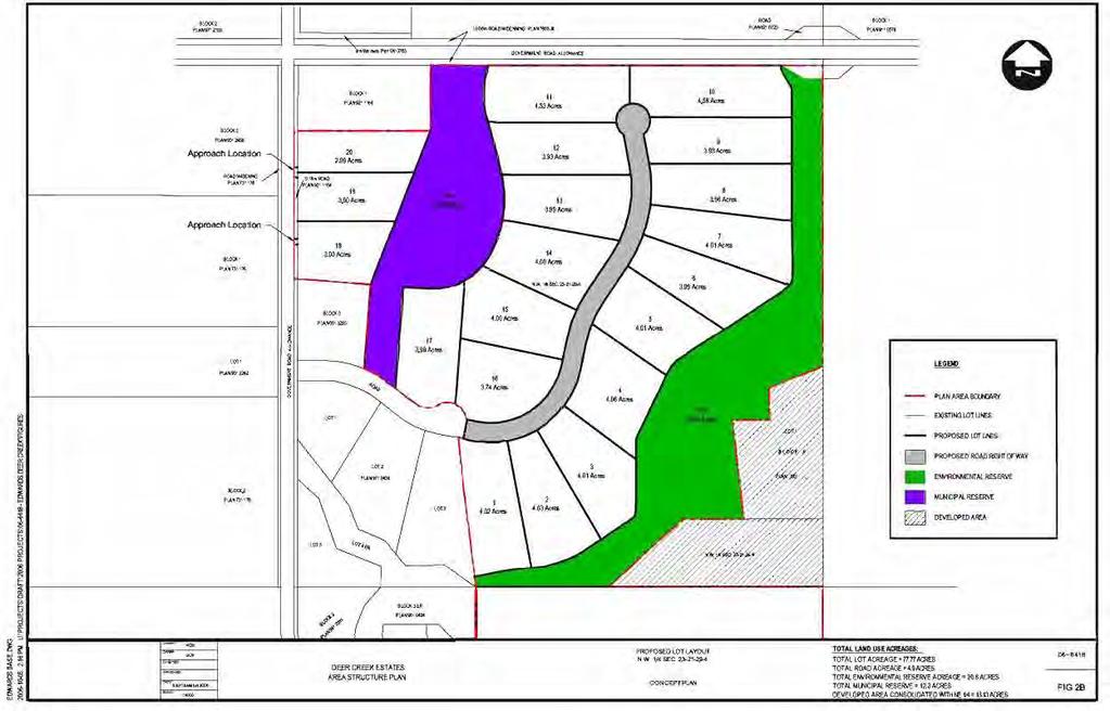
10 Deer Creek Estates Area Structure Plan 4.0 LAND USE STRATEGY Figure 2, 2a, and 2b delineates the proposed lots in the Plan Area. The land use strategy is based on a sequential development pattern recognizing agricultural activity where possible, and allowing for the orderly, efficient and affordable development of infrastructure and services. In all, the Deer Creek Estates development contains 42 lots, (2 municipal reserve lots, 1 environmental reserve lot, 1 agricultural district lot and 38 country residential lots). a. When considering redesignation, subdivision or development applications in the Plan Area, the Municipality shall confirm that the application conforms to the land use strategy illustrated in Figure 2 and is compatible with the policies of this Plan. b. Any application in the Plan Area that is contrary to the land use strategy and policies contained within the Deer Creek Estates ASP requires a formal application for amendment to the Deer Creek Estates ASP. 4.1 History This half section has been previously subdivided. In 1992 a first parcel out from both the NW and SW quarter sections were registered. In 1996 the developer/landowner created a country residential site in the middle of the half section that contained a total of 9 lots and an ER area. Recently, an additional +/- 5.0 acre lot was taken from the SW quarter and a boundary adjustment between the NW quarter and the NE quarter occurred. 4.2 Agricultural Land Use Policies Historically, the Plan Area has been under agricultural use. To date the land has supported the grazing of livestock. Soil consists of a mix of Canada Land inventory ratings of soil classes 3 and 4 with sub classes being 3T and 4T6W. Urban growth pressures due to the proximity to the City of Calgary, increasing nonagricultural land values, demand for country residential development, and conflicts between existing residential and agricultural land use increase pressure for nonagricultural uses. Large scale developments, such as Norris Coulee, have been approved in the vicinity and the area has transitioned away from agriculture. An approximately +/- 60 acre agricultural parcel within the plan area is intended to remain as the primary residence of the landowner/developer and will support small-scale agricultural pursuits (i.e. tree farm). It may be that this parcel subdivides, in the longterm to support additional residences. In order for future subdivision of this +/- 60-acre parcel to occur an amendment to this Area Structure Plan would be required. a. The agricultural parcel within the plan area has limited potential for large scale agricultural pursuits. Small-scale agriculture may occur on this site in the shortterm. Longview Planning + Design 5
11
12
13
14 Deer Creek Estates Area Structure Plan b. It is anticipated that the agricultural parcel will convert to country residential land uses in the long-term. Conversion of these lands to country residential will require an amendment to this ASP. c. Should the agricultural parcel convert to country residential land uses the lands that qualify as Environmental Reserve should also be dedicated. 4.3 Country Residential Land Use Policies Orderly settlement patterns of country residential development should be compatible with the natural environment. Figure 3 provides an outline showing surrounding quarter sections and their country residential density. This area contains an unnamed intermittent drainage course, which has been informally known as Snake Creek, which shall be protected within an Environmental Reserve parcel on the NW quarter. The land generally rolls from a high point in the NW corner to the ravine drainage course area. The SW quarter contains rolling topography, the high point of which is in the SW corner. a. Country residential lots shall not be more than 4.80 acres (1.94 hectares) in size to accommodate single family dwellings. All lots shall be serviced with individual groundwater wells and septic fields. In total the Deer Creek Estates ASP contains 38 country residential lots. b. Country residential Lots shall not exceed 4.80 acres (1.94 hectares) parcels. c. Country residential lots shall be supplied by individual groundwater wells. d. Country residential lots shall have direct access to a surfaced municipal road in accordance with the Municipal Internal Subdivision road policies. Three (3) lots gain access from the Municipal road (48 th Street). All remaining lots gain access from a proposed internal road that connects to 48 th Street. e. Country residential lots shall support single-family dwellings only. The parcel sizes can support three (3) animal units under the M.D. of Foothills Land Use Bylaw. f. In accordance with Transportation Policies contained in Section 6.2, a Traffic Impact Analysis (T.I.A) may be required at the time of redesignation or subdivision for residential purposes. g. Uses on country residential lots shall comply with the Restrictive Covenant registered on title, copied here in Appendix A. Longview Planning + Design 6
15
16 Deer Creek Estates Area Structure Plan 5.0 NATURAL ENVIRONMENT The biophysical characteristics and environmental significance of lands in the Plan Area should be considered in applications for development. Appendix B contains additional detailed information regarding environmental characteristics in the Plan Area (i.e. air photo). 5.1 General Environment Policy a. The Municipality, through its Municipal Development Plan policies, encourages the preservation of significant and/or sensitive natural environments in the development process. b. The Municipality may require that a proponent, in support of a proposal for redesignation, subdivision or development, and at their sole expense, prepare and submit the following in a form and content satisfactory to the Municipality, and in accordance with all pertinent Alberta Environment Protection guidelines or requirements of the appropriate Provincial Departments: 5.2 Topography i. A Geotechnical report pursuant to the provisions of the Municipal Development Plan; ii. An Archaeological and/or Historical Resource Impact Assessment pursuant to the provisions of the Municipal Development Plan and to the satisfaction of the provincial department of Alberta Culture, should it be deemed necessary. This land contains a mix of flat to moderately rolling topography. The most severe topography is associated with the drainage course. The slope range within the proposed country residential lots is less than 15%. a. The Municipality may require at least one geotechnical report prepared by a qualified engineer in areas where topography may be a factor in development. The geotechnical report should contain all information required by the Municipality and as described in MD policy. 5.3 Open Space, Recreation and Public Land Public land consists largely of Municipal Reserve (MR) or Environmental Reserve (ER) areas that have been dedicated to the Municipality upon development. The Municipality can negotiate the amount of land required and its potential public use through the planning process. Longview Planning + Design 7
17 Deer Creek Estates Area Structure Plan Municipal and Environmental Reserve The MR parcels are 4.98 hectares (12.30 acres) and 2.60 hectares (6.42 acres) respectively. The project also contains a 9.34 hectare (23.10 acre) ER parcel that is intended to be utilized by the Municipality for park or recreational uses as it is part of the unnamed drainage course. Land Use Statistics Land Use Number of Acres MR 19.4 ER 23.1 CR Roads 9.50 AG (existing) Total The ER parcel contains slopes and an unnamed drainage course, informally known as Snake Creek. Connections are made to the north and east of the ER parcel for public access. The ER is to remain in its natural state in perpetuity. MR is provided in two locations. An MR parcel is proposed in the NW quarter containing acres (4.98 hectares) with a linear pathway on the perimeter of the Plan Area. This MR is centrally located to the proposed country residential lots. MR in NW quarter is developable, it contains moderate slopes and was chosen as it is central to the community. Its large size and varying topography allow for naturally attractive amenity space (i.e. park, school, recreation). A second MR lot containing 6.42 acres (2.60 hectares) is located in the SW quarter section. The MR in the SW quarter is also developable. It was chosen due to it proximity to the municipal road (48 th Street) and is the buffer between existing lots and the Plan Area. a. The Municipality supports the retention and enhancement of open space and recreation facilities in the municipality. Linkages between, and continuity of, these spaces are encouraged. b. Dedication of Municipal Reserve, either by cash-in-lieu of land or by physical dedication of land, or both, in the Plan Area shall be determined by the Municipality in accordance with the MDP policy and s.666 of the Municipal Government Act. c. Physical land dedication of Municipal Reserve shall consist of lands that are equivalent to the developable lands (i.e. similar in kind to the land being developed). d. Dedication of ER in the Plan Area shall be determined by the Municipality in accordance with MDP policy and s.664 of the Municipal Government Act. Longview Planning + Design 8
18 Deer Creek Estates Area Structure Plan 6.0 INFRASTRUCTURE Infrastructure includes the hierarchy of road networks, public and private water systems, septic systems, solid waste management systems, and police, fire and ambulance service. 6.1 General Infrastructure The quality of infrastructure is a fundamental part of the well-being of a community and its ability to sustain growth over time. To improve the quality of life in the Municipality as a whole, it is important that the Municipality occasionally assess infrastructure as it relates to the planning of communities. The Deer Creek Estates ASP contains policies that recommend improvements, and trigger for assessment of infrastructure over time as the community continues to grow. a. The Municipality has developed a set standard for roads and infrastructure servicing that follows a general hierarchy. The Municipality may require an assessment of necessary infrastructure when considering redesignation, subdivision, and/or development proposals. 6.2 Road Systems Provincial Highway 552 Provincial Highway 552 is administered by Alberta Infrastructure and Transportation (A.I.T.). It is important to ensure that future land uses within the Plan Area do not impair the function and safety of this highway. To this end A.I.T. has additional influence over permitted developments within 0.8 km of the right of way of Provincial Highway 552. No direct access to the highway system is proposed for this development in accordance with A.I.T. policies for this area. The existing direct access to Highway 552 will be removed at the developer s expense and to the satisfaction of Alberta Transportation. a. In accordance with A.I.T. standard practices, no new or direct access to Provincial Highway 552 shall be permitted. b. In addition to Municipal Building and Development Permits, an application within 0.8 kilometres (1/2 mile) of right of way of Provincial Highway 552 requires a Provincial Roadside Development Permit from A.I.T. To ensure that the country residential parcels are not unduly compromised by any future highway expansion, parcels adjacent to the provincial highway may be subject to a 40 m setback requirement measured from the highway right-of-way limit. c. A.I.T. may request a Traffic Impact Analysis (T.I.A.) to be prepared at the time of redesignation or subdivision. The T.I.A. shall be prepared by a qualified transportation engineer, at the sole expense of the developer. The T.I.A. should include, but is not limited to, an analysis and evaluation of: Longview Planning + Design 9
19 Deer Creek Estates Area Structure Plan i. The potential impact of a proposed subdivision, and/or development on the existing transportation network: and ii. A program of future expansion and/or improvement of the transportation network to accommodate the proposed growth and to preserve the function and integrity of the transportation network The Municipal Road Network The plan area gains access directly from 48 th Street, a surfaced Municipal road. The developer/landowner will be required to upgrade 48 th Street as a part of the Deer Creek Development. Over time should the surrounding area develop and utilize 48 th Street for access the developer/landowner would appreciate an endeavour to assist from those proposing subdivision as a result of the road improvement. a. In accordance with municipal policy, the developer may be subject to the Municipal Road Levy or be required to improve the surface of 48th Street at the discretion of Council The Internal Road Network The Plan Area shall be serviced with an internal road that contains two points of ingress/egress from the municipal road system. The internal road will not exceed a grade of 7 % at any point, and will be constructed to municipal standard and paved as required. a. The internal subdivision road shall be constructed to Municipal standard at the sole expense of the developer. Ownership and maintenance of the internal subdivision road shall be the responsibility of the Municipality upon issuance of a Final Acceptance Certificate to the developer. 6.3 Water, Sewer and Storm Water Servicing Water Sources and Resources New, and more restrictive, water policies for groundwater sources have been implemented under the Provincial Water Act. a. The Municipality supports the use of individual water wells licensed in accordance with the Water Act. b. To maintain water quality in the aquifier(s), consideration must be given to proper disposal of sanitary and sewer waste from future developments. Municipal and Provincial codes and standards for on-site disposal shall be the minimum required. c. All future developments shall implement water conservation methods. Longview Planning + Design 10
20 Deer Creek Estates Area Structure Plan d. All storm water management shall be contained within the proposed development area. No surface water shall be directed to highway ditches and post-development flows shall not exceed pre-development. A stormwater management plan may be required Sanitary Sources and Resources There are no communal sewage collection and treatment systems servicing the Plan Area. Treatment of sanitary effluent is generally restricted to on-site disposal through standard septic tile fields as per Alberta Labour regulations. This is typical of domestic use within the M.D. of Foothills. a. On-site sewage disposal system shall be developed to the standards of the Municipality and the Alberta Plumbing Code. b. It is recommended that the calculated Sodium Absorption Ratio (SAR) of the potable water source (SAR calculated at 15.96) be considered in the long-term effectiveness of the disposal field. c. Methods of Open Discharge from a septic tank shall not be permitted. d. Non-evaporative lagoons shall not be permitted. e. Septic Pump-out tanks are discouraged in the Plan Area due to the damage on the road system that loaded septic trucks may cause. f. Alternate systems (i.e. slow sand trickle filters, modified tile field design, Microfast, and full fledge treatment systems such as rotating biological contractors (RBCs), living systems including constructed wetlands) may be considered at the discretion of the Municipality and Alberta Labour Solid Waste Disposal a. The Municipality encourages co-ordination of solid waste disposal systems with urban centres where possible. a. Solid waste from the Deer Creek development shall be hauled by individual landowners to the nearest transfer site Shallow Utilities Shallow utility services include natural gas, telephone, and electricity. ATCO Gas provides gas service to the area. Electrical service is provided primarily by Fortis. Telephone service is provided by Telus. Longview Planning + Design 11
21 Deer Creek Estates Area Structure Plan a. Provision of Shallow Utilities in applications for redesignation, subdivision, and/or development shall be at the sole expense of the developer to the extent required in the Municipal Standard Development Agreement. 6.4 Protective Services The Municipality requires that proposals for redesignation, subdivision, and/or development accommodate design elements that consider safety measures and appropriate levels of servicing required for fire, police, and ambulance services Police Services Police Services to the Plan Area shall be provided by the Royal Canadian Mounted Police and M.D. of Foothills Special Constables Fire Services The Plan Area is serviced by 911 emergency service, with an emergency locator system set up for each individual property. a. New subdivision shall meet the criteria for on-site fire fighting measures as determined by the Municipality. b. Applications for redesignation, subdivision or development shall assure proper emergency vehicle access in accordance with Municipality Policy. 7.0 IMPLEMENTATION, REVIEW AND AMENDMENT 7.1 Plan Implementation The Deer Creek Estates ASP falls within a hierarchy of applicable plans as illustrated in Section 2. The M.D. of Foothills Municipal Development Plan (MDP) is the guiding document for all development within the municipality. The Land Use Bylaw (LUB) establishes the land use rules and regulations. The Deer Creek Estates ASP presents a greater level of planning detail within the specific Plan Area and is required to be consistent with both the MDP and LUB. Development in the Plan Area should be acceptable to community and consistent with policy contained within the Deer Creek Estates ASP. The Deer Creek Estates ASP does not supersede, repeal, replace or otherwise diminish any other statutory plan in effect in the Plan Area. a. The policies contained within this document shall be reviewed and implemented by Municipal District of Foothill s Council members at their discretion. 7.2 Plan Review and Amendment Longview Planning + Design 12
22 Deer Creek Estates Area Structure Plan As the Deer Creek Estates ASP is a bylaw of the Municipality, a formal process as outlined in the Municipal Government Act is required to amend the Plan. a. The future land use and development outlined in the Deer Creek Estates ASP is intended to address a long-term time horizon. Periodic review and occasional amendment of the Deer Creek Estates ASP may be required in accordance with the Municipal Government Act. The Deer Creek Estates ASP is flexible enough to allow for review and amendment every five years should the Municipality deem that appropriate. Longview Planning + Design 13
23 APPENDIX A: RESTRICTIVE COVENANT Longview Planning + Design - 1 -
24 RESTRICTIVE COVENANT DEER CREEK DEVELOPMENTS LIMITED / GARY EDWARDS, of Dewinton, Alberta (hereinafter referred to as the Developer ), is the registered owner of certain lands situated near Dewinton, in the Province of Alberta, and more particularly described in Schedule A attached hereto and by this reference made a part hereof (hereinafter collectively called the lots or individually referred to as a lot as the context hereof requires); AND WHEREAS the developer is developing a planned housing subdivision on the lots and considers it is desirable for the greater employment of the lots and that it will increase and the value of the lots and it is for the benefit of all of the future owners of the individual lots and that it will protect the owner of each lot against the improper development and use of surrounding lots as will depreciate the value of his lot and that it will prevent haphazard or inharmonious improvements or improper designs or materials, to impose and annex certain restrictions and covenants to the lots and that in making sales of the lots that the lots shall be conveyed subject to the restrictions, covenants and limitations hereinafter set forth; AND WHEREAS the following covenants and conditions are to be administered and some discretion will be allowed where specifics of an application warrant and there is no substantial departure from the intent and substance of this Restrictive Covenant. NOW THEREFORE KNOW ALL PERSON BY THESE PRESENTS that the developer does for himself, his transferees and assigns, covenants and agrees and does hereby annex the following covenants and conditions to the aforesaid lots: 1. All of the lots shall be subject to the restrictions and conditions herein set forth which shall be deemed to be covenants running with the land and annexed to the land and shall be binding upon and inured to the benefit of each lot and the registered owners of each lot, while they are such registered owners from time to time. 2. No attached or semi-attached house, duplex or apartment shall be constructed or erected, nor shall any house designated for more than one family be built. There shall not be constructed more than one detached single family dwelling on any one lot and every single family dwelling must have at least a two-car attached garage. 3. No mobile home shall be parked or placed on any lot. The phrase mobile home shall herein include a house or trailer or other similar portable accommodation for one or more persons that may be moved by being towed, pulled or carried. 4. The buildings erected on any lot shall include, only, a private single dwelling house with attached double or triple garage. A structure to conceal recreational Longview Planning + Design - 2 -
25 trailers and recreational vehicles may be constructed provided it conforms to the architectural style and exterior finish of the dwelling house. There shall not be constructed on any lot any structures to conceal heavy equipment, gasoline tanks and other fuel tanks and stands thereof. Garden sheds and greenhouses may be constructed provided they conform to the architectural style and exterior finish of the dwelling house and do not exceed three hundred square feet. 5. Gary Edwards / Deer Creek Developments Ltd. must approve all drawings for Building permits prior to their submission to the Municipal District of Foothills No Outbuildings / Accessory buildings are permitted but are additionally subject to review and approval by Gary Edwards/Deer Creek Developments Ltd. prior to submission to the MD of Foothills No If a lot owner wishes to store a recreational vehicle, it must be a recreational vehicle which is owned by the lot owner and is restricted to one of such recreational vehicle. 8. No fuel, gasoline, oil, chemicals of any nature or biological waste (excepting waste in properly installed septic tanks) shall be stored on any lots in an amount excess of 100 liters. 9. The minimum habitable floor area, excluding basement, of any single family dwelling upon any lot shall be: a) 1,800 square feet for a bungalow or bi-level dwelling; b) 1,400 square feet for a split level or two storey dwelling; In calculating the ground area of a dwelling house, the measurements for the above calculations shall be taken as the outside measurements of the main walls of the building and ground level and shall not include any garage which does not have habitable rooms above it and shall not include any porch, veranda or unheated sunroom. 10. No dwelling house on any single lot shall be used for any purpose other than that of a private dwelling for a single family. 11. Construction must start no less than 24 months after purchase of lot. 12. Resale of lots without a home is prohibited unless permission by Gary T. Edwards is given. 13. All driveways must be paved within 12 months of move in to the primary residence. Longview Planning + Design - 3 -
26 14. The exterior finish, roof, windows, log finish, siding or stucco of any single family dwelling must be completed within 12 months of the initial excavation of the foundation of the said dwelling. No vinyl siding shall be permitted. Siding shall be a wood product only. No bright colors (i.e. pink, orange). No bright colours on the exterior of the home shall be permitted and the building façade is required to have 25% rock or brick. 15. The roof pitch of the dwelling must be 6 of 12. The roof finish must be cedar shakes, pine shakes, clay or ceramic tiles, top of the line shingles heritage style or architectural asphalt shingles. 16. Any garden shed or greenhouse erected on the property shall be architecturally compatible with the said dwelling house or commensurate with the country residential subdivision, utilizing the same roofing materials as the dwelling house with only steel, aluminum, log finish, or stucco sidings acceptable. The front façade of buildings require 25% rock or brick. 17. Perimeter fencing must match the original 3 rail fence installed by the developer. 18. Grass shall be maintained by the lot owner and shall not exceed 6 in height. All properties will be landscaped, grassed or other landscape material. Weeds are not permitted to grow and must be maintained. 19. Any garden shed or greenhouse erected on the property must be sided and completed within 12 months of the commencement of construction of building. 20. The interior of the dwelling and final building inspection shall be fully completed (excluding any basement development) within 24 months of commencement of the initial excavation of the foundation thereof. 21. No heavy equipment or tractor trailers shall be stored or operated on the property other than for the purpose of construction of the dwelling or improvement of the property. In the event that a lot owner is an owner or operator of such equipment for commercial purposes, such equipment shall not be stored or operated within the subdivision other than as set out above. 22. The owner, his family, and guests shall not operate or permit the operation of motorized vehicles on public areas, such as riding trails, Environmental Reserve, Municipal Reserve, or ditches. 23. If a lot owner is to keep dogs on their lot, suitable fences or electric restraint systems are to be installed to ensure that any such dogs do not leave the lot owner s property. No lot owner shall have any more than two (2) dogs on the property and the dog(s) must be confined indoors between the hours of 10:00 p.m. Longview Planning + Design - 4 -
27 and 6:00 a.m. Excessive barking shall not be tolerated. If Bylaw Enforcement has been called and if three (3) or more valid complaints are received the owner shall remove the dogs from their property. 24. No livestock or animals of any nature shall be raised on the lot for commercial purposes. 25. If any of the preceding covenants is determined to be void or unenforceable, in whole or in part, such invalidity or unenforceability of that covenant(s) shall not affect any other covenant and the remaining covenant(s) shall be deemed to be separate and distinct covenants. 26. Household and other garbage must be removed for the property at least monthly and disposed of in accordance with the local laws at the expense of the landowner. 27. Sewage disposal is the responsibility of the individual lot owner and shall be in accordance with the requirements of the Municipal District of Foothills and provincial regulations. 28. Purchasers /homeowners are aware that they reside in a developed area and accept that Gary Edwards / Deer Creek Developments Ltd. will be the primary developer of the subject lands and this may include lands within the immediate vicinity. By acquiring a lot in the subject development the purchaser / homeowner forfeits the right to object to or otherwise interrupt the ongoing development work of Gary Edwards / Deer Creek Developments Ltd. On the subject property and any other property within the Dunbow road / DeWinton area. 29. No covenants herein shall be deemed to restrict any provision of any development control bylaw, development control resolutions, zoning regulation or land use regulation, or any other similar bylaw, resolution or regulation, passed or imposed by any governmental authority but the covenants herein are to be considered as additional restrictions. 30. These covenants shall be and are deemed to be covenants running with the land and shall be personally binding upon the successors and assigns of the property herein referred to. 31. This Agreement shall not merge upon the delivery or registration of a Transfer of any lot but shall survive same. 32. If any of the preceding covenants is determined to be void or unenforceable, in whole or in part, such invalidity or unenforceability shall affect the validity or enforceability of any other covenant, and the covenant herein shall be deemed to be separate and distinct covenants. Longview Planning + Design - 5 -
28 33. If any debate or difference arises over the interpretation of the restrictions and conditions herein contained or as to the stage of construction or location of any buildings, such as a dispute or difference shall be determined by Gary T. Edwards whose decision shall be final and binding. IN WITNESS WHEREOF the Developer have hereunto set there hands and corporate seals, this day of SIGNED IN PRECENSE OF: Gary Edwards Witness Longview Planning + Design - 6 -
29 APPENDIX B: AIR PHOTO Longview Planning + Design - 7 -


30
31 APPENDIX C: CERTIFICATE OF TITLE Longview Planning + Design - 8 -
32 ALBERTA REGISTRIES LAND TITLE CERTIFICATE S LINC SHORT LEGAL TITLE NUMBER ;29;21;23;NW LEGAL DESCRIPTION MERIDIAN 4 RANGE 29 TOWNSHIP 21 SECTION 23 QUARTER NORTH WEST CONTAINING 64.7 HECTARES (160 ACRES) MORE OR LESS EXCEPTING THEREOUT: PLAN NUMBER HECTARES (MORE OR LESS) ACRES ROAD 7605JK ROAD SUBDIVISION SUBDIVISION SUBDIVISION SUBDIVISION SUBDIVISION EXCEPTING THEREOUT ALL MINES AND MINERALS ESTATE: FEE SIMPLE MUNICIPALITY: MUNICIPAL DISTRICT OF FOOTHILLS NO. 31 REFERENCE NUMBER: REGISTERED OWNER(S) REGISTRATION DATE(DMY) DOCUMENT TYPE VALUE CONSIDERATION /07/2006 SUBDIVISION PLAN OWNERS GARY T EDWARDS OF BOX 16, SITE 4, RR # 1 DEWINTON ALBERTA T0L 0X0 ( CONTINUED )
33 ENCUMBRANCES, LIENS & INTERESTS PAGE 2 REGISTRATION # NUMBER DATE (D/M/Y) PARTICULARS /05/1996 UTILITY RIGHT OF WAY GRANTEE - CANADIAN WESTERN NATURAL GAS COMPANY LIMITED /02/1997 UTILITY RIGHT OF WAY GRANTEE - FORTISALBERTA INC AVENUE S.W. CALGARY ALBERTA T2S2Y1 (DATA UPDATED BY: TRANSFER OF UTILITY RIGHT OF WAY ) (DATA UPDATED BY: CHANGE OF NAME ) /12/2000 RESTRICTIVE COVENANT /12/2000 CAVEAT RE : DEFERRED RESERVE CAVEATOR - THE MUNICIPAL DISTRICT OF FOOTHILLS NO. 31. BOX 5605 HIGH RIVER ALBERTA T1V1M /09/2003 MORTGAGE MORTGAGEE - FIRST CALGARY SAVINGS & CREDIT UNION LTD. P.O. BOX 908, CALGARY ALBERTA T2P2J6 ORIGINAL PRINCIPAL AMOUNT: $1,900,000 TOTAL INSTRUMENTS: 005 THE REGISTRAR OF TITLES CERTIFIES THIS TO BE AN ACCURATE REPRODUCTION OF THE CERTIFICATE OF TITLE REPRESENTED HEREIN THIS 28 DAY OF SEPTEMBER, 2006 AT 02:19 P.M. ORDER NUMBER: CUSTOMER FILE NUMBER: *END OF CERTIFICATE* ( CONTINUED )
34 THIS ELECTRONICALLY TRANSMITTED LAND TITLES PRODUCT IS INTENDED FOR THE SOLE USE OF THE ORIGINAL PURCHASER, AND NONE OTHER, SUBJECT TO WHAT IS SET OUT IN THE PARAGRAPH BELOW. THE ABOVE PROVISIONS DO NOT PROHIBIT THE ORIGINAL PURCHASER FROM INCLUDING THIS UNMODIFIED PRODUCT IN ANY REPORT, OPINION, APPRAISAL OR OTHER ADVICE PREPARED BY THE ORIGINAL PURCHASER AS PART OF THE ORIGINAL PURCHASER APPLYING PROFESSIONAL, CONSULTING OR TECHNICAL EXPERTISE FOR THE BENEFIT OF CLIENT(S). PAGE 3
35 ALBERTA REGISTRIES HISTORICAL LAND TITLE CERTIFICATE CURRENT TITLE WITH HISTORICAL DATA S LINC SHORT LEGAL TITLE NUMBER ;29;21;23;SW LEGAL DESCRIPTION MERIDIAN 4 RANGE 29 TOWNSHIP 21 SECTION 23 QUARTER SOUTH WEST CONTAINING 64.7 HECTARES (160 ACRES) MORE OR LESS EXCEPTING THEREOUT: PLAN NUMBER HECTARES (ACRES) MORE OR LESS SUBDIVISION SUBDIVISION SUBDIVISION EXCEPTING THEREOUT ALL MINES AND MINERALS ESTATE: FEE SIMPLE MUNICIPALITY: MUNICIPAL DISTRICT OF FOOTHILLS NO. 31 REFERENCE NUMBER: REGISTERED OWNER(S) REGISTRATION DATE(DMY) DOCUMENT TYPE VALUE CONSIDERATION /02/1996 SUBDIVISION PLAN OWNERS GARY T EDWARDS OF BOX 16 SITE 4, RR 1 DEWINTON ALBERTA T0L 0X0 ( CONTINUED )
36 ENCUMBRANCES, LIENS & INTERESTS PAGE 2 REGISTRATION # NUMBER DATE (D/M/Y) PARTICULARS /09/1977 UTILITY RIGHT OF WAY GRANTEE - CANADIAN WESTERN NATURAL GAS COMPANY LIMITED. AS TO PORTION OR PLAN: "TAKES PRIORITY OF CAVEAT REGISTERED 10/09/1976" /05/1995 MORTGAGE MORTGAGEE - PROVINCE OF ALBERTA TREASURY BRANCHES. P.O. BOX 1020, OKOTOKS ALBERTA ORIGINAL PRINCIPAL AMOUNT: $200, /11/1995 CAVEAT RE : DEVELOPMENT AGREEMENT CAVEATOR - THE MUNICIPAL DISTRICT OF FOOTHILLS NO. 31. BOX 5605 HIGH RIVER ALBERTA T1V1M7 AGENT - JUDY HOFFER /02/1996 UTILITY RIGHT OF WAY GRANTEE - CANADIAN WESTERN NATURAL GAS COMPANY LIMITED /04/1996 RESTRICTIVE COVENANT /04/1996 RESTRICTIVE COVENANT /07/1996 MORTGAGE MORTGAGEE - PROVINCE OF ALBERTA TREASURY BRANCHES. BOX 1020, OKOTOKS ALBERTA T0L1T0 ORIGINAL PRINCIPAL AMOUNT: $50, /11/1999 MORTGAGE MORTGAGEE - THE BANK OF NOVA SCOTIA. NO. 102, SOUTHPORT ROAD SW CALGARY ALBERTA T2W4X9 ORIGINAL PRINCIPAL AMOUNT: $258, /01/2000 DISCHARGE OF MORTGAGE /03/2001 MORTGAGE ( CONTINUED )
37 ENCUMBRANCES, LIENS & INTERESTS PAGE 3 REGISTRATION # NUMBER DATE (D/M/Y) PARTICULARS MORTGAGEE - FIRST CALGARY SAVINGS & CREDIT UNION LTD. P.O. BOX 908, CALGARY ALBERTA T2P2J6 ORIGINAL PRINCIPAL AMOUNT: $600, /03/2001 DISCHARGE OF MORTGAGE /09/2001 DISCHARGE OF MORTGAGE /09/2003 MORTGAGE MORTGAGEE - FIRST CALGARY SAVINGS & CREDIT UNION LTD. P.O. BOX 908, CALGARY ALBERTA T2P2J6 ORIGINAL PRINCIPAL AMOUNT: $1,900, /11/2003 DISCHARGE OF MORTGAGE TOTAL INSTRUMENTS: 014 THE REGISTRAR OF TITLES CERTIFIES THIS TO BE AN ACCURATE REPRODUCTION OF THE CERTIFICATE OF TITLE REPRESENTED HEREIN THIS 29 DAY OF JUNE, 2006 AT 09:59 A.M. ORDER NUMBER: CUSTOMER FILE NUMBER: *END OF CERTIFICATE* THIS ELECTRONICALLY TRANSMITTED LAND TITLES PRODUCT IS INTENDED FOR THE SOLE USE OF THE ORIGINAL PURCHASER, AND NONE OTHER, SUBJECT TO WHAT IS SET OUT IN THE PARAGRAPH BELOW. THE ABOVE PROVISIONS DO NOT PROHIBIT THE ORIGINAL PURCHASER FROM INCLUDING THIS UNMODIFIED PRODUCT IN ANY REPORT, OPINION, APPRAISAL OR OTHER ADVICE PREPARED BY THE ORIGINAL PURCHASER AS PART OF THE ORIGINAL PURCHASER APPLYING PROFESSIONAL, CONSULTING OR TECHNICAL EXPERTISE FOR THE BENEFIT OF CLIENT(S).
Wapiti Ridge Estates Area Structure Plan SE W5M. December Prepared For:
 SE 13-20-1 W5M December 2000 Prepared For: 393494 Alberta Limited, and The Municipal District of Foothills No. 31 Prepared By: Kristi Beunder Professional Planning Services Calgary, Alberta Ph: 201-3309
Prt. NE W5. Prepared for: Municipal District of Foothills #31. Prepared by:
 Prt. NE 22-22-3-W5 Prepared for: Municipal District of Foothills #31 Prepared by: Bowwood Land Services Inc. R.R. 1, Dewinton, Alberta T0L 0X0 Tel: 403-995-2225 Fax: 403-938-4787 " OFFICIAL COPY " ADOPTED
The Land Titles. Restrictive Covenant. Heartland Projects Ltd. A corporation in the Province of Alberta. (Hereinafter referred to as the Grantor )
") The Land Titles Restrictive Covenant This Restrictive Covenant DATED this day of June, 2016 Between: And: Heartland Projects Ltd. A corporation in the Province of Alberta. (Hereinafter referred to as the
The Land Titles Restrictive Covenant This Restrictive Covenant DATED this day of June, 2016 Between: And: Heartland Projects Ltd. A corporation in the Province of Alberta. (Hereinafter referred to as the
Lorne and Leanne Read Sundance Trail Phase II Area Structure Plan Amendment
 A SPRING 2008 CO-14264 Municipal District of Foothills No. 31 Lorne and Leanne Read Sundance Trail Phase II Area Structure Plan Amendment Lorne and Leanne Read SUNDANCE TRAIL AREA STRUCTURE PLAN - AMENDMENT
BAR NONE RANCHES AREA STRUCTURE PLAN. Ptn. NE W5M, M.D. Foothills No May 2017
 BAR NONE RANCHES AREA STRUCTURE PLAN Ptn. NE 34-20-0 W5M, M.D. Foothills No. 3 8 May 207 PREPARED FOR THE MUNICIPAL DISTRICT OF FOOTHILLS NO. 3 ADOPTED BY COUNCIL BYLAW (INSERT NUMBER) APPROVAL DATE (INSERT
Conceptual Scheme SE W4
 December 2012 1. PURPOSE 1.1. The purpose of a Conceptual Scheme (CS) is as follows: a) To provide a framework for the subsequent subdivision and/or development of land within the Country Residential Policy
PLANNING SERVICES FORM 3.3 SUBDIVISION APPLICATION COMMERCIAL OR BUSINESS PURPOSES
 FOR OFFICE USE ONLY Date of Receipt File Number Fee Submitted SUBDIVISION APPLICATION COMMERCIAL OR BUSINESS PURPOSES Accepted by Please note that the information provided in these forms is crucial to
City of Grande Prairie Development Services Department
 City of Grande Prairie Development Services Department COUNTRYSIDE SOUTH OUTLINE PLAN Prepared by: GPEC Consulting Ltd. #202, 10712-100th Street Grande Prairie, AB Council Resolution of August 20, 2001
SUBDIVISION APPLICATION
 PLANNING AND DEVELOPMENT SERVICES 38106 Rge Rd 275, Red Deer County, AB T4S-2L9 Phone: (403) 350-2170 Fax: (403) 346-9840 For Office Use Only File # Roll # Fee Submitted Date Deemed Complete Reference
RURAL GENERAL RG 1. PERMITTED USES DISCRETIONARY USES
 RURAL GENERAL RG PURPOSE: To protect the agricultural land base of the municipality while allowing nonagricultural developments which complement the area's economy. 1. PERMITTED USES DISCRETIONARY USES
Subdivision - Application
 Planning and Development Services, 2001 Sherwood Drive, Sherwood Park, AB T8A 3W7 Phone 780-464-8080 Fax 780-464-8109 Email: Landuse&policyplanning@strathcona.ca (Page 1 of 5) This form is to be completed
Regional District of Central Kootenay Subdivision Bylaw No. 2159, 2011
 Regional District of Central Kootenay Subdivision Bylaw No. 2159, 2011 Adopted September 2011 Page 1 of 21 TABLE OF CONTENTS PART 1 - TITLE... 2 PART 2 - PURPOSE... 2 PART 3 - APPLICATION AND ADMINISTRATION...
ACCESSORY DWELLING UNITS
 ACCESSORY DWELLING UNITS LAND USE BYLAW C-4841-97 ACCESSORY DWELLING UNIT (ADU): means a subordinate dwelling unit attached to, created within or detached from the principal dwelling, single detached,
MUNICIPAL DISTRICT OF ROCKY VIEW NO. 44 ELBOW VALLEY WEST DIRECT CONTROL DISTRICT BYLAW C
 This document has been consolidated for convenience only. A current listing of any and all amendments can be obtained from the Municpal District Office Bylaw No. Date of Approval Amendment Type Bylaw C-6042-2005
THIRD AMENDED DECLARATION OF COVENANTS, CONDITIONS AND RESTRICTIONS FOR TIMBER RIDGE
 THIRD AMENDED DECLARATION OF COVENANTS, CONDITIONS AND RESTRICTIONS FOR TIMBER RIDGE THE STATE OF TEXAS KNOW ALL MEN BY THESE PRESENTS: COUNTY OF BURNET WHEREAS, TIMBER RIDGE is an unrecorded subdivision
UTILITY RIGHT-OF-WAY AND EASEMENT
 THE LAND TITLES ACT UTILITY RIGHT-OF-WAY AND EASEMENT I (We), Hauser Development Corp., of Buck Lake, in the Province of Alberta, Canada (hereinafter call the Grantor ) being registered owner of an estate
TOTTENHAM SECONDARY PLAN
 TOTTENHAM SECONDARY PLAN AMENDMENT NO. 11 TO THE OFFICIAL PLAN OF THE TOWN OF NEW TECUMSETH The following text and schedules to the Official Plan of the Town of New Tecumseth constitute Amendment No. 11
RESTRICTIVE COVENANT AND DECLARATION OF BUILDING SCHEME
 RESTRICTIVE COVENANT AND DECLARATION OF BUILDING SCHEME TO: THE REGISTAR OF THE NORTH ALBERTA LAND REGISTRATION DISTRICT EDMONTON, ALBERTA WHEREAS: A. 1491096 ALBERTA LTD. (hereinafter called the Developer
DECLARATION OF RESTRICTIVE COVENANTS OF THE RANCH SUBDIVISION
 DECLARATION OF RESTRICTIVE COVENANTS OF THE RANCH SUBDIVISION THIS DECLARATION OF RESTRICTIVE COVENANTS is made this day of September, 2013, by 4T Ranch Developers, Inc. ( Developer ). WITNESSETH: WHEREAS
AGREEMENT OF PURCHASE AND SALE
 AGREEMENT OF PURCHASE AND SALE Approved by the Nova Scotia Real Estate Commission (NSREC) for use by licensees under the Real Estate Trading Act. FORM 400 PAGE 1 OF 3 Total # of pages in this Agreement
19.12 CLUSTER RESIDENTIAL DISTRICT
 Chapter 19.12 CLUSTER RESIDENTIAL DISTRICT (Adopted 12/22/2003; Ordinance #0061970). Amended 7/3/17, Ordinance #079100. Section 19.12.010 - Declaration of Intent. The Cluster Residential District provides
AMENDED RESTRICTIONS FOR GRAND OAK ESTATES BEAUMONT, JEFFERSON COUNTY, TEXAS
 AMENDED RESTRICTIONS FOR GRAND OAK ESTATES BEAUMONT, JEFFERSON COUNTY, TEXAS On this 9 day of January, 1996, Graff Development Company, L.C., hereinafter called Developer joined herein by all current owners
Stormwater Ordinance Appendix APPENDIX K EXAMPLE TAR-PAM CONVERSATION EASEMENT
 APPENDIX K EXAMPLE TAR-PAM CONVERSATION EASEMENT Tax Parcel ID # NORTH CAROLINA FRANKLIN COUNTY CONSERVATION EASEMENT Franklin County, North Carolina THIS CONSERVATION EASEMENT (this "Conservation Easement")
WENTWORTH PHASE 1. RESTRICTIVE COVENANT AND EASEMENT Pursuant to Sections 48(1) and 68(1) of the Land Titles Act, Alberta
 and 68(1) of the Land Titles Act, Alberta") WW1SF-RC -1- RESTRICTIVE COVENANT AND EASEMENT Pursuant to Sections 48(1) and 68(1) of the Land Titles Act, Alberta RECITALS: 101. Dundee Development Corporation (herein called Dundee ), a body corporate
WW1SF-RC -1- RESTRICTIVE COVENANT AND EASEMENT Pursuant to Sections 48(1) and 68(1) of the Land Titles Act, Alberta RECITALS: 101. Dundee Development Corporation (herein called Dundee ), a body corporate
POLICY AMENDMENT AND LAND USE AMENDMENT RICHMOND (WARD 8) RICHMOND ROAD SW AND 24 STREET SW BYLAWS 10P2018 AND 52D2018
 RICHMOND ROAD SW AND 24 STREET SW BYLAWS 10P2018 AND 52D2018") Page 1 of 12 EXECUTIVE SUMMARY This land use amendment proposes to redesignate two parcels of approximately 0.30 hectares ± (0.74 acres ±) located in the community of Richmond from DC Direct Control District
Page 1 of 12 EXECUTIVE SUMMARY This land use amendment proposes to redesignate two parcels of approximately 0.30 hectares ± (0.74 acres ±) located in the community of Richmond from DC Direct Control District
CITY OF DUNES CITY LANE COUNTY, OREGON ORDINANCE NO. 228
 CITY OF DUNES CITY LANE COUNTY, OREGON ORDINANCE NO. 228 AN ORDINANCE AMENDING TITLE XV OF THE DUNES CITY CODE OF ORDINANCES BY REPEALING CHAPTER 157 ENTITLED SEPTIC SYSTEM MAINTENANCE, AMENDING TITLE
AGENDA 1. CALL TO ORDER :00 P.M.
 MUNICIPAL PLANNING COMMISSION REGULAR MEETING CITY HALL COUNCIL CHAMBERS SEPTEMBER 24, 2015 AGENDA 1. CALL TO ORDER ------------------------------------------------------------------------ 7:00 P.M. 2.
Shawnee Woods Subdivision
 Shawnee Woods Subdivision Declaration of Restrictions WHEREAS, D & P Inc. Lakeview Development LLC, Developer, having heretofore executed a plat of Shawnee Woods, which plat was recorded on the 11 th day
Land Dedication (Reserves)
") Land Dedication (Reserves) This technical document is part of a series of draft discussion papers created by Municipal Affairs staff and stakeholders to prepare for the Municipal Government Act Review.
Land Dedication (Reserves) This technical document is part of a series of draft discussion papers created by Municipal Affairs staff and stakeholders to prepare for the Municipal Government Act Review.
For Vintages of Four Mile Creek Town of Niagara on the Lake, Ontario
 Planning Impact Analysis For Vintages of Four Mile Creek Town of Niagara on the Lake, Ontario Prepared by: Upper Canada Consultants 261 Martindale Road Unit #1 St. Catharines, Ontario L2W 1A1 Prepared
Town of Bristol Rhode Island
 Town of Bristol Rhode Island Subdivision & Development Review Regulations Adopted by the Planning Board September 27, 1995 (March 2017) Formatted: Highlight Formatted: Font: 12 pt Table of Contents TABLE
DECLARATION OF RESTRICTIONS AND EASEMENTS OF OAKWOOD MEADOWS SUBDIVISION
 DECLARATION OF RESTRICTIONS AND EASEMENTS OF OAKWOOD MEADOWS SUBDIVISION WHEREAS, OAKWOOD MEADOWS, a subdivision of part of the Southwest quarter of Section 24, Town 1 North, Range 6 East, Green Oak Township,
The Council of the Municipal District of Foothills No. 31 met at the Foothills Administration Building, High River, Alberta, for a meeting on
 The Council of the Municipal District of Foothills No. 31 met at the Foothills Administration Building, High River, Alberta, for a meeting on September 13, 2017 at 9:00 a.m. Present were Mayor L. Spilak,
 Deed Restrictions Deed Restrictions Tax Parcel Nos.:11-026.00-132,l33,158 & 159 Prepared BY: Nichols Development 2842 Pulaski Hwy. Newark, DE 19702 PERCH CREEK COMMUNITY DECLARATION OF RESTRICTIONS THIS
W I T N E S S E T H: ARTICE I
 STATE OF NORTH CAROLINA COUNTY OF WAKE PROTECTIVE COVENANTS THIS DECLARATION, made this 29th day of September 1978, by STURBRIDGE DEVELOPMENT COMPANY, INC., a North Carolina corporation, hereinafter called
AS YOUR COMMUNITY EVOLVES, SO DOES OUR SUPPORT.
 AS YOUR COMMUNITY EVOLVES, SO DOES OUR SUPPORT. The Amended, Modernized and About to be Strengthened, Municipal Government Act A Presentation to CPAA Conference May 2017 Presented by: MUNICIPAL Charlotte
PURCHASE AGREEMENT. 4. CONTINGENCIES. This Purchase Agreement is contingent upon the satisfaction of the following conditions:
 PURCHASE AGREEMENT 1. PARTIES. This purchase agreement (the Purchase Agreement ) is made this day of, 2017, by and between the County of Carver, Minnesota, a public body politic and corporate having the
SUBDIVISION Application Information
 Application Information COMPLETE THE ATTACHED APPLICATION FORM by printing clearly or filling out all of the required fields electronically. The application must be signed by the registered owner(s) of
Rural Municipality of Kellross No Official Community Plan. Bylaw No
 Rural Municipality of Kellross No. 247 Official Community Plan Bylaw No. 2009-03 2 BYLAW NO. 2009-03 THE RURAL MUNICIPALITY OF KELLROSS NO. 247 LEROSS, SASKATCHEWAN A Bylaw of the Rural Municipality of
DISTRICT OF SICAMOUS BYLAW NO A bylaw of the District of Sicamous to establish a Revitalization Tax Exemption Program
 DISTRICT OF SICAMOUS BYLAW NO. 917 A bylaw of the District of Sicamous to establish a Revitalization Tax Exemption Program WHEREAS under the provisions of Section 226 of the Community Charter, the Council
DOUGLAS COUNTY ZONING RESOLUTION Section 4 LRR - Large Rural Residential District 3/10/99. -Section Contents-
 SECTION 4 LRR LARGE RURAL RESIDENTIAL DISTRICT -Section Contents- 401 Intent... 4-2 402 Principal Uses... 4-2 403 Accessory Uses... 4-3 404 Uses Permitted by Special Review... 4-4 405 Land Dedication...
Chapter 100 Planned Unit Development in Corvallis Urban Fringe
 100.100 Scope and Purpose. Chapter 100 Planned Unit Development in Corvallis Urban Fringe (1) All applications for land divisions in the Urban Residential (UR) and Flood Plain Agriculture (FPA) zones within
Residential Project Convenience Facilities
 Standards for Specific Land Uses 35.42.220 E. Findings. The review authority shall approve a Land Use Permit in compliance with Subsection 35.82.110.E (Findings required for approval) or a Conditional
STATE OF NORTH CAROLINA * * DECLARATION OF RESTRICTIONS * OF CAROLINA SANDS, SECTIONS 1 and 2 COUNTY OF NEW HANOVER *
 STATE OF NORTH CAROLINA * AMENDED * DECLARATION OF RESTRICTIONS * OF CAROLINA SANDS, SECTIONS 1 and 2 COUNTY OF NEW HANOVER * KNOW ALL MEN BY THESE PRESENTS, THAT WHEREAS by written instrument dated September
8Land Use. The Land Use Plan consists of the following elements:
 8Land Use 1. Introduction The Land Use Plan consists of the following elements: 1. Introduction 2. Existing Conditions 3. Opportunities for Redevelopment 4. Land Use Projections 5. Future Land Use Policies
APPLICATION FOR SUBDIVISION APPROVAL Summary of Application Review & Approval Process and Application Form April 1, 2009
 Land Planning Branch, (K-320LP) Phone 667-8877 Fax 393-6340 APPLICATION FOR SUBDIVISION APPROVAL Summary of Application Review & Approval Process and Application Form April 1, 2009 THE SUBDIVISION APPLICATION,
ADMINISTRATION RECOMMENDATION(S) 2017 January 26. That Calgary Planning Commission recommends APPROVAL of the proposed Land Use Amendment.
 2017 January 26. That Calgary Planning Commission recommends APPROVAL of the proposed Land Use Amendment.") WEST OF NORTHMOUNT AND CHARLESWOOD Page 1 of 7 EXECUTIVE SUMMARY This land use amendment application seeks to redesignate a single residential parcel located in the community of Brentwood from Residential
WEST OF NORTHMOUNT AND CHARLESWOOD Page 1 of 7 EXECUTIVE SUMMARY This land use amendment application seeks to redesignate a single residential parcel located in the community of Brentwood from Residential
SUPPLEMENTARY REQUIREMENTS SPECIFIED PENALTIES FOR OFFENCES RIPARIAN SETBACK MATRIX MODEL RURAL APPROACH STANDARDS POLICY COMMUNITY STANDARDS BYLAW
 APPENDICES APPENDIX A APPENDIX B APPENDIX C APPENDIX D APPENDIX E APPENDIX F APPENDIX G APPENDIX H APPENDIX I APPENDIX J APPENDIX K SUPPLEMENTARY REQUIREMENTS TELECOMMUNICATION TOWERS CONFINED FEEDING
To ensure a smooth transition from the County to City jurisdiction for planning and development regulation
 City of Grande Prairie Municipal Development Plan and Land Use Bylaw Concept for transitioning Short Term Annexation Area lands into the City s policy framework and land use development control regime.
CITY OF SURREY BY-LAW NO A Bylaw to establish a revitalization tax exemption program...
 CITY OF SURREY BY-LAW NO. 16120 A Bylaw to establish a revitalization tax exemption program... WHEREAS a City Council may, pursuant to Section 226 of the "Community Charter" establish a revitalization
LAND USE AMENDMENT SPRINGBANK HILL (WARD 6) ELMONT DRIVE SW AND 69 STREET SW BYLAW 114D2017
 ELMONT DRIVE SW AND 69 STREET SW BYLAW 114D2017") Page 1 of 8 EXECUTIVE SUMMARY This land use amendment application proposes to redesignate and subdivide 1.15 hectares of land located within the southwest community of East Springbank to accommodate 17
Page 1 of 8 EXECUTIVE SUMMARY This land use amendment application proposes to redesignate and subdivide 1.15 hectares of land located within the southwest community of East Springbank to accommodate 17
4. If any perennial surface water passes through or along the property lines of the acreage, a minimum of 200 feet or frontage should be required.
 b. Provide adequate acreage for appropriate productive use of rural residential land, such as small numbers of livestock, large gardens, etc. 3. Minimum of 200 feet of frontage on an improved county or
DEVELOPMENT AGREEMENT RIVER EDGE COLORADO PLANNED UNIT DEVELOPMENT
 DEVELOPMENT AGREEMENT RIVER EDGE COLORADO PLANNED UNIT DEVELOPMENT THIS AGREEMENT, is made and entered into between the BOARD OF COUNTY COMMISSIONERS OF THE COUNTY OF GARFIELD, a body politic and corporate
A. Preserve natural resources as identified in the Comprehensive Plan.
 1370.08 Conservation Residential Overlay District. Subd. 1 Findings. The City finds that the lands and resources within the Conservation Residential Overlay District are a unique and valuable resource
PLANNED UNIT DEVELOPMENTS
 PLANNED UNIT DEVELOPMENTS SECTION 9.01 DESCRIPTION AND PURPOSE. A. The purpose of a planned unit development (PUD) is to permit greater flexibility in development than is generally possible under standard
PLANNING PROCEDURES AND FEES BYLAW
 PLANNING PROCEDURES AND FEES BYLAW The following is a consolidated copy of the planning procedures and fees bylaw and includes the following bylaws: Bylaw No. Bylaw Name Adopted Purpose 328 Comox Valley
8.5.1 R1, Single Detached Residential District
 8.5.1 R1, Single Detached Residential District The purpose of this district is to provide for residential development in the form of single detached dwellings. Dwelling, Single Detached Home Business,
CITY OF SARALAND FINAL SUBDIVISION PLAT REVIEW
 CITY OF SARALAND FINAL SUBDIVISION PLAT REVIEW Application Number: Date Plat Submitted: Name of Subdivision: Name of Owner: Owner Address: (Street or P.O. Box) Telephone #: (City) (State) (Zip) E-mail:
Chair and Members Planning and Economic Development Committee
 TO: FROM: Chair and Members Planning and Economic Development Committee Melissa Halford Manager of Planning DATE: June 23, 2016 SUBJECT: Amendment No. 6 to Draft Approval Subdivision File No. S2006-3 (Loon
Telecommunications Development Permit Application Package
 Telecommunications Development Permit Application Package POLICY POL#308 Title: Policy Guidelines to Evaluate Commercial Communications Facilities Legal References: Radio Communication Act Municipal Government
Conceptual Scheme SE W4
 Conceptual Scheme September 2014 Conceptual Scheme 1. PURPOSE 1.1. The purpose of a Conceptual Scheme (CS) is as follows: a) To provide a framework for the subsequent subdivision and/or development of
Subdivision Application Package RURAL MUNICIPALITY
 Subdivision Application Package RURAL MUNICIPALITY Oldman River Regional Services Commission 3105 16 th Avenue North Lethbridge AB T1H 5E8 Phone: 403-329-1344 or 1-844-279-8760 Website: www.orrsc.com Email:
FINAL DRAFT 12/1/16, Rev. to 7/18/17
 FINAL DRAFT 12/1/16, Rev. to 7/18/17 (As Adopted 8/8/17 Effective 9/1/17) SHELTON PLANNING AND ZONING COMMISSION Proposed Amendments to Zoning Regulations I. Amend Section 23 PERMITTED USES by inserting
Corman Park - Saskatoon Planning District Official Community Plan
 1 Corman Park - Saskatoon Planning District Official Community Plan CONSOLIDATED: October, 2017 2 Table of Contents Bylaw Amendments... 3 Section 1: Foundations... 4 Section 2: Future Growth Sector Objectives
DECLARATION OF RESTRICTIVE COVENANTS
 DECLARATION OF RESTRICTIVE COVENANTS The Declarant,, is the fee simple owner of the certain real property located in County, Kansas, as described on Exhibit A, which is attached hereto and incorporated
DECLARATION OF PROTECTIVE COVENANTS FOR GREEN HILL SUBDIVISION
 DECLARATION OF PROTECTIVE COVENANTS FOR GREEN HILL SUBDIVISION STATE OF GEORGIA. COUNTY OF HALL COMES NOW, Saddle Creek Development, LLC ("Owner/Developer"), as record owner of all that tract or parcel
CANYON BEACH PROPERTIES LTD. ARCHITECTURAL CONTROL AND BUILDING AND DEVELOPMENT GUIDELINES
 CANYON BEACH PROPERTIES LTD. ARCHITECTURAL CONTROL AND BUILDING AND DEVELOPMENT GUIDELINES This document serves as the standard Architectural Controls, Building Specifications and Development Guidelines
AMENDMENT AND RESTATEMENT OF RESTRICTIVE COVENANTS
 AMENDMENT AND RESTATEMENT OF RESTRICTIVE COVENANTS WHEREAS, on July 11, 1978, a Declaration of Restrictions was filed with the Director of Records for Jackson County, Missouri at Independence under Document
AMENDED RESTRICTIVE COVENANTS
 AMENDED RESTRICTIVE COVENANTS of WOODHAVEN HOMES, INC. State of North Carolina, County of Henderson This is a copy of the current Covenants. The original of this document was filed with the Henderson County
Guide to Preliminary Plans
 Guide to Preliminary Plans Introduction The Douglas County is committed to providing open, transparent application processes to the public. This Guide is provided to assist anyone interested in the procedures
ORANGE BLOSSOM GARDENS PLANNED UNIT DEVELOPMENT PREPARED BY: COASTAL ENGINEERING CONSULTANTS, INC.
 ORANGE BLOSSOM GARDENS A PLANNED UNIT DEVELOPMENT PREPARED BY: COASTAL ENGINEERING CONSULTANTS, INC. REVISED OCTOBER 19, 1992 BY THE COLLIER COUNTY LONG RANGE PLANNING DEPARTMENT REVISED DECEMBER, 2008
DEED RESTRICTIONS PROTECTIVE COVENANTS
 DEED RESTRICTIONS PROTECTIVE COVENANTS The undersigned, being owner of the property on North Territorial Road and as described on the attached exhibit known as Exhibit A do, this day of April, 2006; HEREBY
PLANNING REPORT. Lot 5, SDR Lot 6 and 7 Concession 3 Township of Normanby Municipality of West Grey County of Grey
 PLANNING REPORT Dwelling Surplus to a Farm Operation Official Plan and Zoning By-law Amendment and Consent to Sever Lot 5, SDR Lot 6 and 7 Concession 3 Township of Normanby Municipality of West Grey County
Attached is a Clinton Township Zoning Permit Application and requirements for issuance of a permit.
 To Whom It May Concern: Attached is a Clinton Township Zoning Permit Application and requirements for issuance of a permit. The fee for the permit application is $75.00, which shall be made payable to
GENERAL POLICIES GOVERNING LAND USE AND CITY LAND SALES IN WAUSAU WEST BUSINESS AND INDUSTRIAL PARK
 GENERAL POLICIES GOVERNING LAND USE AND CITY LAND SALES IN WAUSAU WEST BUSINESS AND INDUSTRIAL PARK Introduction: Wausau West Business and Industrial Park is recognized as an important asset to the City
MUNICIPALITY OF THE DISTRICT OF CLARE SUBDIVISION BY-LAW
 MUNICIPALITY OF THE DISTRICT OF CLARE SUBDIVISION BY-LAW 1 Table of Contents PART 1 - TITLE... 4 PART 2 - INTERPRETATION... 4 PART 3 - DEFINITIONS... 4 PART 4 - PROCEDURE FOR APPROVAL OF PLANS OR INSTRUMENTS
PROVINCIAL SUBDIVISION REGULATIONS. Municipal Government Act
 PROVINCIAL SUBDIVISION REGULATIONS Made under Section 270 of the Municipal Government Act Chapter 18 of the Statutes of Nova Scotia, 1998 Service Nova Scotia and Municipal Relations April 1, 1999 (with
Fraser River Escarpment Policy
 Fraser River Escarpment Policy Building Permit Requirements Page 1 of 2 This summary has been prepared by Inspections Services to assist property owners/builders in understanding the policies relating
MSC Ridgewood Subdivision
 Ay' MSC 2011 12523 CERTIFICATE OF RECORD STATE OF ARKANSAS cowl, I of WHITE CERTIFY THAT THIS INSTRUMENT WAS FILED FOR RECORD AN,D IS RECORDED AS STAMPED HEREON. DATE a - 3- I The. 1: mspry) BOOK Bill
SECTION III - RESTRICTIVE COVENANTS
 , dated August 26, 1986 and recorded September 2, 1986 as Document No. 8622978: Lots 1-117, 118-152 SECTION III - RESTRICTIVE COVENANTS The covenants and restrictions contained in this instrument shall
SUBDIVISION AND DEVELOPMENT REGULATION
 Province of Alberta MUNICIPAL GOVERNMENT ACT SUBDIVISION AND DEVELOPMENT REGULATION Alberta Regulation 43/2002 With amendments up to and including Alberta Regulation 188/2017 Office Consolidation Published
Financial Impact Statement There are no immediate financial impacts associated with the adoption of this report.
 STAFF REPORT Planning and Development Department Subject: Application by RYC Property to rezone a portion of lands on John Murray Dr. and Megan Lynn Dr. from R2 to R3 and to enter into a Development Agreement
RESIDENTIAL AND RECREATIONAL
 Energy, Mines & Resources Land Management Branch 320-300 Main Street Whitehorse, Yukon Y1A 2B5 667-5215 Fax 667-3214 www.emr.gov.yk.ca RESIDENTIAL AND RECREATIONAL Lot Enlargement Policy OBJECTIVE To facilitate
MINUTES OF THE MUNICIPAL PLANNING COMMISSION Tuesday, May 5, 2015 Red Deer County Council Chambers, Red Deer County Centre
 MINUTES OF THE MUNICIPAL PLANNING COMMISSION Tuesday, May 5, 2015 Red Deer County Council Chambers, Red Deer County Centre Present: Absent: Chairman Councillor P.J.R. Massier, Mayor J.J. Wood, Councillors
Canar Pines. DECLARATION OF DEVELOPMENT COVENANTS and RESTRICTIONS
 Canar Pines DECLARATION OF DEVELOPMENT COVENANTS and RESTRICTIONS Salmon Investments, LLC and/or Michael J Miller, herein referred to as developer, the owner of a parcel of land, the legal description
APPLICATION FOR SITE PLAN CONTROL
 APPLICATION FOR SITE PLAN CONTROL Information and material to be provided under Section 41 of the Planning Act Township of Lanark Highlands PO Box 340, 75 George Street Lanark, ON K0G 1K0 T: 613.259.2398
CITY OF KELOWNA BYLAW NO
 SUMMARY: The Development Cost Charge Bylaw sets out the charges imposed for roads, water, sanitary sewer, drainage and public park when subdividing or constructing, altering or extending a building, pursuant
COMPLETE AND SIGN LAND USE AMENDMENT APPLICATION FORM (attached) MUNICIPAL DISTRICT OF GREENVIEW NO. 16
 MUNICIPAL DISTRICT OF GREENVIEW NO. 16") LAND USE AMENDMENT APPLICATION PACKAGE Municipal District of Greenview 4806 36 Avenue, Box 1079, Valleyview AB T0H 3N0 T 780.524.7600 F 780.524.4307 Toll Free 1.866.524.7608 www.mdgreenview.ab.ca COMPLETE
LAND USE AMENDMENT APPLICATION PACKAGE Municipal District of Greenview 4806 36 Avenue, Box 1079, Valleyview AB T0H 3N0 T 780.524.7600 F 780.524.4307 Toll Free 1.866.524.7608 www.mdgreenview.ab.ca COMPLETE
A Guide to the Municipal Planning Process in Saskatchewan
 A Guide to the Municipal Planning Process in Saskatchewan A look at the municipal development permit and the subdivision approval process in Saskatchewan May 2008 Prepared By: Community Planning Branch
*DO NOT REMOVE * R (Redekop) Darbyshire Drive
 Darbyshire Drive") *DO NOT REMOVE * R16-022 (Redekop) 33770 Darbyshire Drive This Public Hearing Information Package has been compiled to provide information pertaining to the subject property. If you have questions regarding
*DO NOT REMOVE * R16-022 (Redekop) 33770 Darbyshire Drive This Public Hearing Information Package has been compiled to provide information pertaining to the subject property. If you have questions regarding
Title: ENCROACHMENT POLICY Number: 0132 Reference: Administrative Committee January 21, Adopted by City Council: February 2, 2009
 POLICY Title: ENCROACHMENT POLICY Number: 0132 Reference: Administrative Committee January 21, 2009 February 2, 2009 Supersedes: May 2, 2005 Prepared by: PLANNING, BUILDING AND DEVELOPMENT SERVICES STATEMENT
Covenant A relating to Stage 7 Riemore Downs, Tamborine Page 1 of 8 TABLE OF CONTENTS INTRODUCTION 3 1. WATER SUPPLY 3 2.
 Covenant A relating to Stage 7 Riemore Downs, Tamborine Page 1 of 8 TABLE OF CONTENTS INTRODUCTION 3 1. WATER SUPPLY 3 2. WATER TANKS 3 3. DOMESTIC WASTE WATER TREATMENT PLANTS 3 4. APPROVAL OF PLANS 3
UPPER MOUNT BETHEL TOWNSHIP NORTHAMPTON COUNTY, PENNSYLVANIA
 UPPER MOUNT BETHEL TOWNSHIP NORTHAMPTON COUNTY, PENNSYLVANIA JOINDER DEED / LOT CONSOLIDATION TOWNSHIP REVIEW PROCESS When accepting proposed Joinder Deeds / Lot Consolidations, review the Joinder Deed
FIRST AMENDED DEED RESTRICTION
 RECORDED AT THE POLK COUNTY COURTHOUSE IN VOLUME 349, PAGES 850 TO 854 STATE OF TEXAS COUNTY OF POLK FIRST AMENDED DEED RESTRICTION WHEREAS, the undersigned DON E. WARFIELD, and C. L. CONNER, CO- TRUSTEES,
Subdivision Application Package URBAN MUNICIPALITY
 Subdivision Application Package URBAN MUNICIPALITY Oldman River Regional Services Commission 3105 16 th Avenue North Lethbridge AB T1H 5E8 Phone: 403 329 1344 Website: www.orrsc.com Email: subdivision@orrsc.com
4. facilitate the construction of streets, utilities and public services in a more economical and efficient manner;
 PVPC MODEL BYLAW BY-RIGHT CLUSTER ZONING BYLAW Prepared by Pioneer Valley Planning Commission Revised: October 2001 1.00 Development 1.01 Development Allowed By Right Development in accordance with this
Protective Covenants Section One
 Protective Covenants Section One For your protection as a home owner these restrictions and covenants have been provided. These Restrictions are applicable to the numbered lots appearing on the Plat entitled
DECLARATION OF COVENANTS, CONDITIONS, AND RESTRICTIONS OF MAPLE TREE HOMES ASSOCIATION, INC.
 DECLARATION OF COVENANTS, CONDITIONS, AND RESTRICTIONS OF MAPLE TREE HOMES ASSOCIATION, INC. (A Missouri Non-Profit Corporation) KNOW ALL PERSONS BY THESE PRESENTS: That Maple Tree Homes Association, Inc.,
Bylaw No , being "Official Community Plan Bylaw, 2016" Schedule "A" DRAFT
 Bylaw No. 2600-2016, being "Official Community Plan Bylaw, 2016" Schedule "A" Urban Structure + Growth Plan Urban Structure Land use and growth management are among the most powerful policy tools at the
AMENDED DECLARATION OF COVENANTS FOR COUNTRY CREEK SUBDIVISION
 AMENDED DECLARATION OF COVENANTS FOR COUNTRY CREEK SUBDIVISION THIS AMENDED DECLARATION OF COVENANTS, made this 17th day of February, 2004, by Frontier Land Company, an Indiana corporation (hereinafter