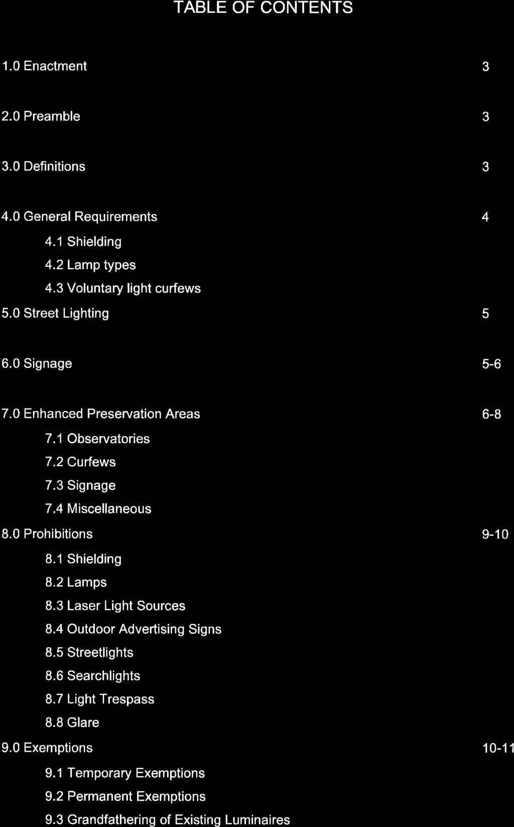
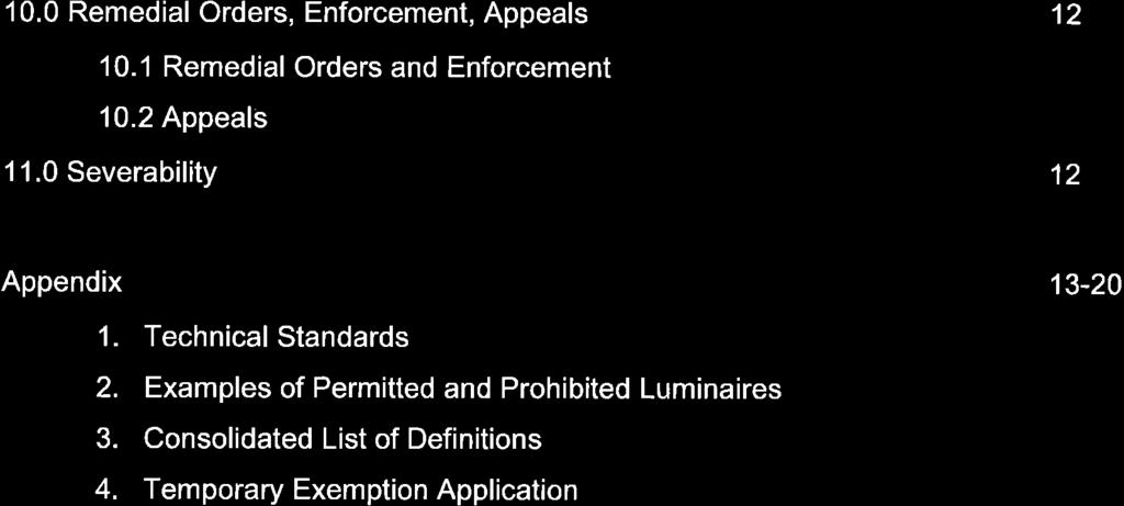
SUPPLEMENTARY REQUIREMENTS SPECIFIED PENALTIES FOR OFFENCES RIPARIAN SETBACK MATRIX MODEL RURAL APPROACH STANDARDS POLICY COMMUNITY STANDARDS BYLAW
|
|
|
- Ralph Neal
- 5 years ago
- Views:
Transcription
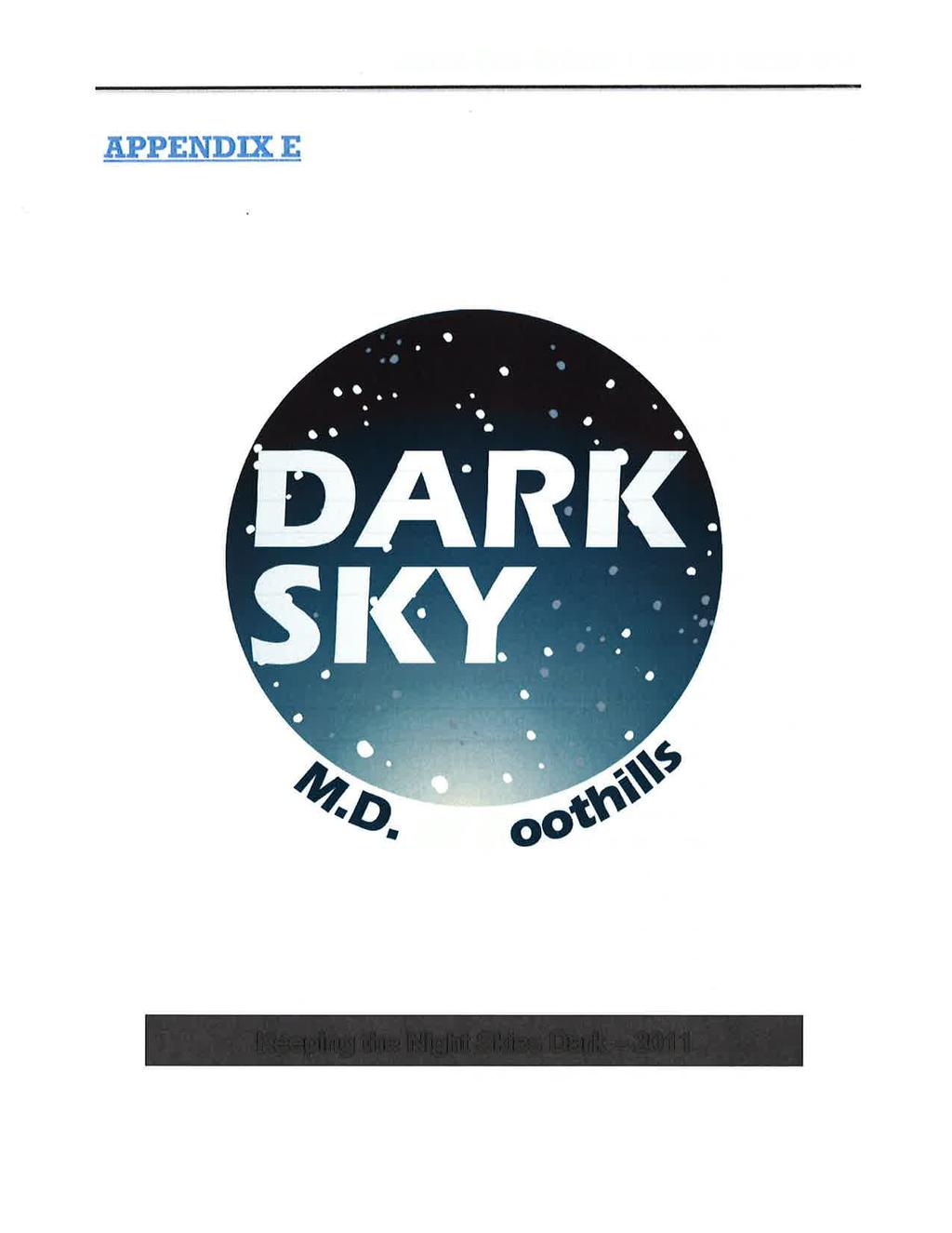
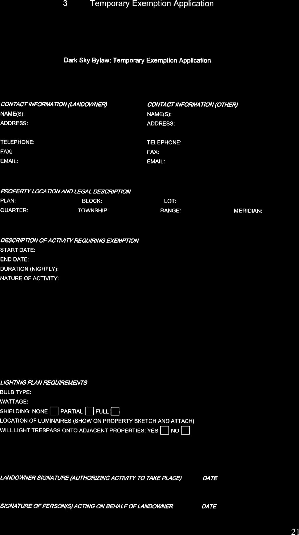
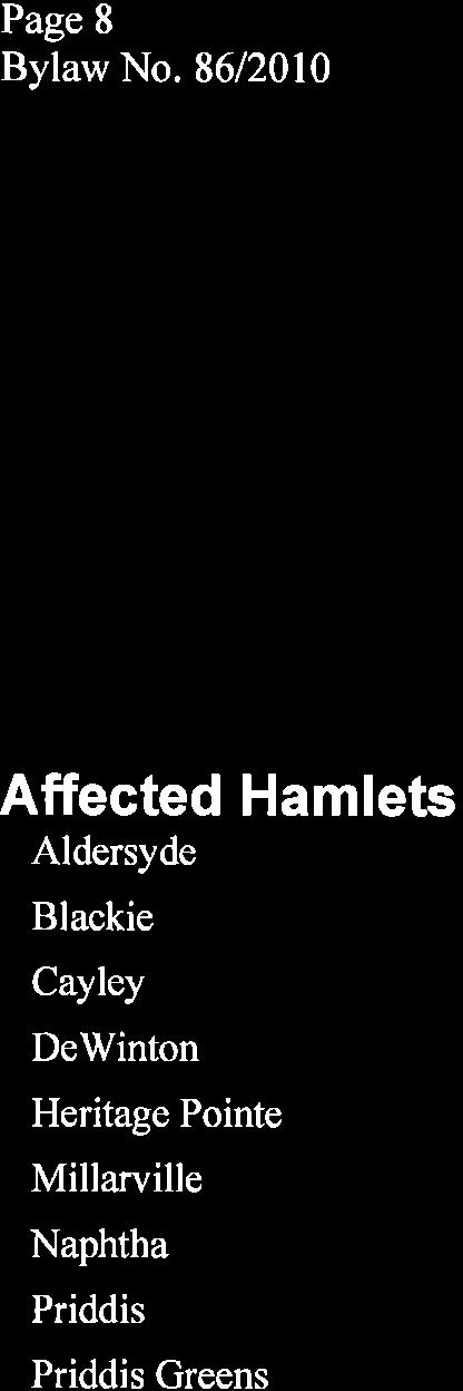
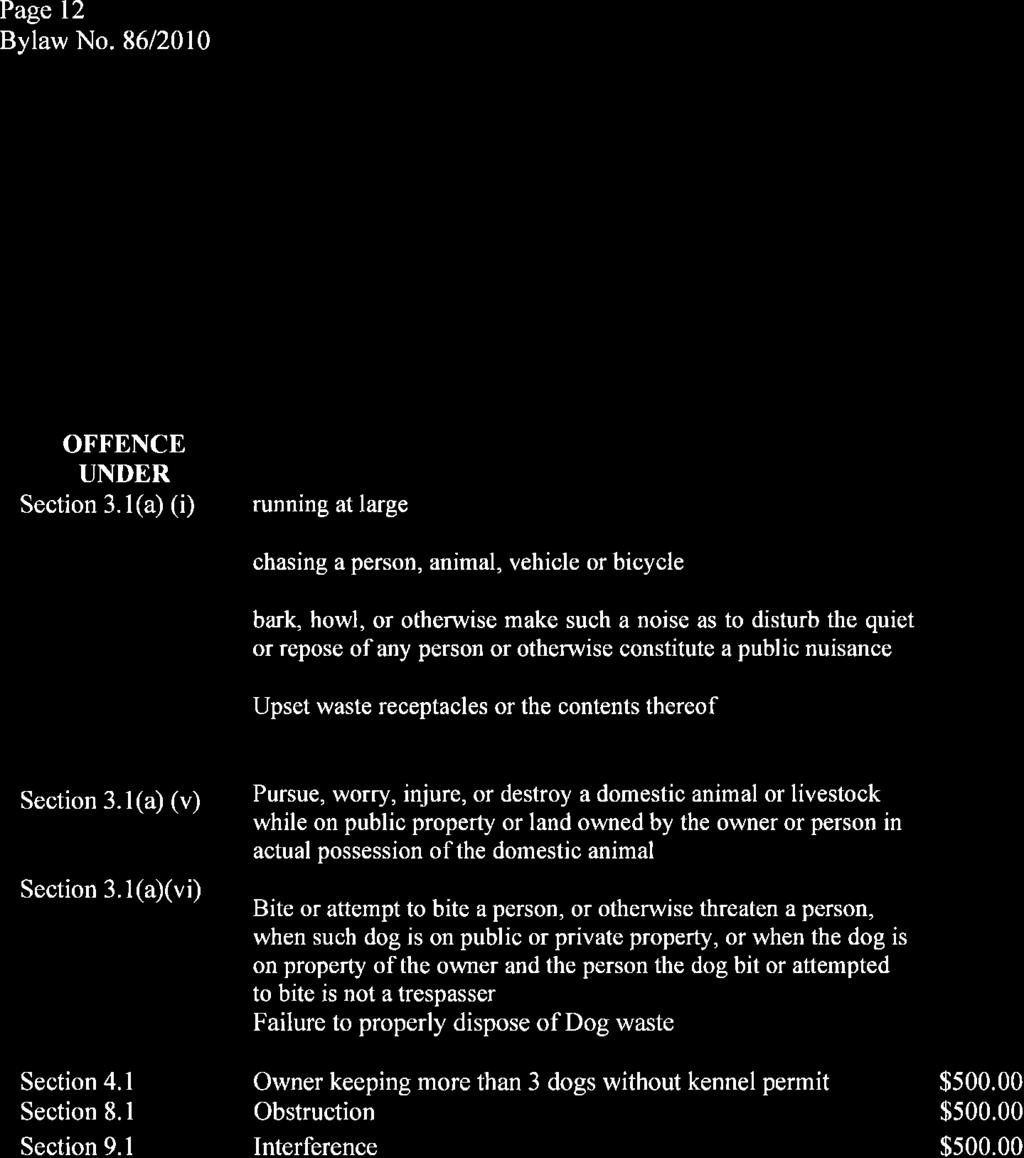
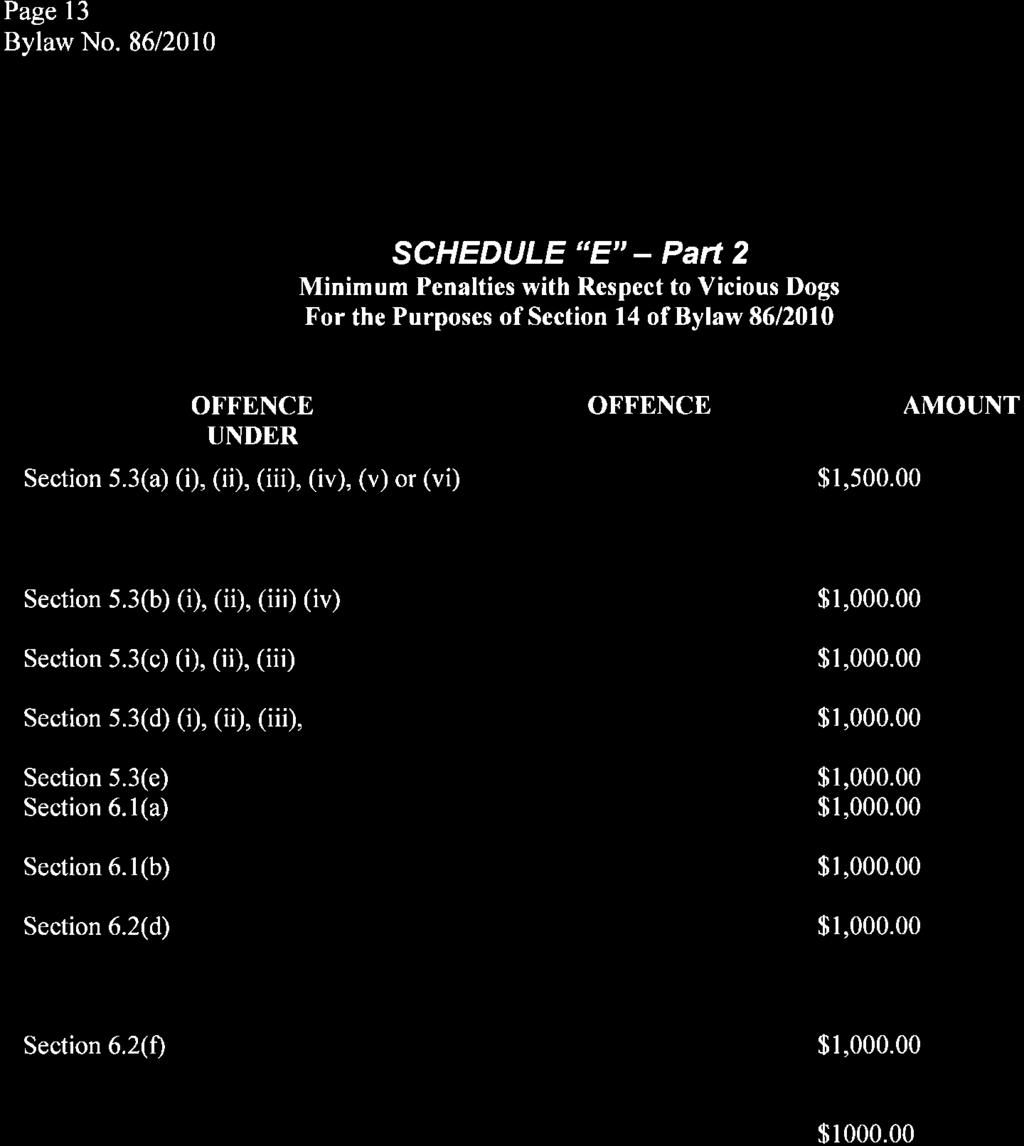
1 APPENDICES APPENDIX A APPENDIX B APPENDIX C APPENDIX D APPENDIX E APPENDIX F APPENDIX G APPENDIX H APPENDIX I APPENDIX J APPENDIX K SUPPLEMENTARY REQUIREMENTS TELECOMMUNICATION TOWERS CONFINED FEEDING OPERATIONS SPECIFIED PENALTIES FOR OFFENCES DARK SKY BYLAW RIPARIAN SETBACK MATRIX MODEL SCREENING STANDARDS SPECIAL EVENTS BYLAW RURAL APPROACH STANDARDS POLICY COMMUNITY STANDARDS BYLAW BYLAW FOR THE REGULATION AND CONTROL OF DOGS
2 Municipal District of Foothills No Land Use Bylaw APPENDIX A SUPPLEMENTARY REQUIREMENTS TECHINICAL STUDIES BIOPHYSICAL ASSESSMENT Prepared by a qualified professional biologist accredited by the Alberta Society of Professional Biologists (ASPB), identifying rare plant and wildlife species/communities, as listed on the current Alberta Natural Heritage Information Center (ANHIC) and Committee on the Status of Endangered Wildlife in Canada (COSEWIC). The findings of this report shall assist in the preparation of the environmental management plan and/or concept plan. ENGINEERING PLANS AND SPECIFICATIONS/CONSTRUCTION DRAWINGS. These are required in support of your application to establish the parameters for the construction of improvements associated with the proposed development. Engineering plans and specifications must be completed by qualified professional engineer accredited by APEGGA and include the following: o o o o o o o o o o o o o Cover Sheet(s); Clearing and Grading Drawings; Roads, Lanes and Walkways Drawings; Traffic Control and Signage Drawing; Water Distribution Drawing (if applicable); Water Distribution Disinfection and Flushing Drawing (if applicable); Sanitary Sewer Drawing (if applicable); Storm Sewer Drawing - Major/Minor System; Storm Sewer Drawing Minor System; Shallow Utilities Drawing; Building Grade Drawing; Landscape Drawing; Erosion Control and Sedimentation Drawing. Upon completion, two sets of complete construction drawings are required to be submitted to the MD of Foothills for preliminary review and approval. Page 1
3 Municipal District of Foothills No Land Use Bylaw Additional circulation of the shallow utilities plan is required to be circulated by the developer to appropriate utility companies for review and approval. Each utility company is required to submit an approval letter for inclusion within the development agreement via the developer. Upon acceptance, a final set of construction drawings may be required for inclusion within the development and servicing agreement in support of the proposed development. For additional details on drawing specifications, and requirements and development agreement procedures please refer to Section 2 of the General Engineering Guidelines and Municipal Servicing Standards. ENVIRONMENTAL MANAGEMENT PLAN An Environmental Management Plan prepared by a qualified professional biologist accredited by the Alberta Society of Professional Biologists (ASPB), indicating the impact of the proposed development on the wildlife, wildlife corridors, vegetation, water and environmental features. The environmental management plan shall outline protection measures in accordance with environmental guidelines and also address mitigation measures, including necessary setbacks distances from significant natural features to mitigate potential impacts born by the proposed development on the surrounding natural environment. The environmental management plan shall also identify breeding and spawning times for wildlife, and the timing of construction and reclamation activities shall be adjusted accordingly. The findings of this report shall assist in the preparation of the concept plan where required. Fire Protection Plan. A fire protection plan is required to ensure adequate improvements to support fire suppression in the case of an emergency within the proposed development area. The fire protection plan must be prepared and submitted to the local fire authority for review and approval with confirmation provided to the MD of Foothills. Once approved, the owner is responsible for implementing those improvements as outlined within the approved fire protection plan as these will be included within the terms of the development agreement where appropriate. During a fire emergency, a copy of the approved fire safety plan must be available for the responding fire department s use. In general terms, the fire protection plan should include: o o o o o o Key contact information including site location and access arrangements; Utility services (including shut-off valves for water, gas and electric); Access issues to the property; Layout, drawing, and location of water supply within the subject property; Layout and location of fire suppression infrastructure; Incorporation of Fire Smart Principles. Page 2
4 Municipal District of Foothills No Land Use Bylaw Where required, the findings of this report should be incorporated within the servicing study and/or engineering plans and specifications requested in support of the proposed development. FLOOD RISK ASSESSMENT (FRA). A Flood Risk Assessment study, completed by a qualified professional accredited by the Association of Professional Engineers and Geoscientists of Alberta (APEGA), shall ascertain whether the development area is suitable for the proposed uses by a. determining the risk of flooding at the site now and in the future (a minimum 100-year flood event); and b. considering the consequences of the site being flooded and provide recommended mitigation measures and design standards to guide the construction of improvement within the subject lands. Setback requirements shall also form part of the recommendations and shall be outlined both in writing and graphically through supportive mapping drawn to scale and related to local elevations. Where required, the findings of this report should be incorporated within the servicing study and/or engineering plans and specifications requested in support of the proposed development. GEOTECHNICAL REPORT A Geotechnical Report shall be prepared by qualified professional engineer accredited by APEGGA, identifying and assessing the subsurface soil and groundwater conditions liable to affect suitability of the lands to support the proposed development. The geotechnical assessment shall be in accordance with the General Engineering Guidelines and Municipal Servicing Standards. The report shall provide conclusions and recommendations to guide the design and construction of the proposed development and associated improvements including both Municipal infrastructure and/or private improvements proposed on the subject property inclusive of buildings, structures and/or private services. Where required, the findings of this report shall be incorporated within the servicing study and/or engineering plans and specifications requested in Support of the proposed development. GROUNDWATER SUPPLY EVALUATION (GSE). A Groundwater Supply Evaluation, completed by a qualified professional accredited by APEGGA, shall assess the potential for one or more aquifers to supply a sustainable volume of water to the proposed development, in addition to determining any possible interference with groundwater supply from existing wells in the area. Page 3
5 Municipal District of Foothills No Land Use Bylaw The evaluation shall involve the completion of a single well within the proposed development area pumping over a Municipally legislated time period, followed by a period of recovery over the same time period. Please note that the groundwater supply evaluation must satisfy those requirements as noted under Section 23(3) (a) of the Province of Alberta Water Act. Should the results of the groundwater supply evaluation indicate that insufficient groundwater supply exists to support the proposed development or impact on existing wells within the area would be profound; the study shall outline alternative means of water supply to the proposed development. This shall include the source of an alternative potable water supply to support the proposed development, and infrastructure to support the water distribution. All alternative means of water supply shall comply with all Federal, Provincial, and Municipal regulations. Where required, the findings of this report should be incorporated within the servicing study and/or engineering plans and specifications requested in support of the proposed development. Hazards Assessment & Management Plan. The Hazards Assessment and Management plan shall identify any and all potential hazards in relation to the proposed development and how they shall be managed. Suggested hazards include but are not limited to fire, petro chemicals and processing chemicals. PRIVATE SEWAGE SYSTEM SUITABILITY ANALYSIS. The Private Sewage System Suitability Analysis report represents a specific geotechnical investigation of the proposed development area documenting prevailing soil conditions, a soil texture analysis and soil suitability assessment to support an on-site private sewage disposal system. This report must be completed by a qualified professional and in accordance with the Alberta Private Sewage Systems Standard of Practice Where required, the findings of this report should be incorporated within the servicing study and/or engineering plans and specifications requested in support of the proposed development. PUBLIC CONSULTATION PLAN In order to ascertain the opinions and concerns of surrounding landowners with regards to the proposed development concept, consultation with the public will need to be undertaken. In support of a conceptual development or subdivision plan, the consultation should be with landowners and/or residents within a minimum of one half mile of the subject property, shall be fully documented in writing and shall include the following information: a. the names and contact information of all attendees; b. a synopsis of matters discussed; c. a summary of concerns raised; d. a formal response to all concerns raised. Page 4
6 Municipal District of Foothills No Land Use Bylaw The time and place of the public meeting must be advertised in Western Wheel for two consecutive weeks prior to the meeting and written notification shall be given to Planning Department of the MD of Foothills. Further, a mail out must be prepared in support of the open house which may be distributed by the MD of Foothills on behalf of the applicant in support of the public consultation. The applicant shall bear all costs. RECLAMATION REPORT. The reclamation report shall outline the measures to be taken to return the development site to an equivalent land capability, as based on pre-disturbance site assessments of soil, landscape, and vegetation. The plan shall also establish criteria and specifications to guide the design, installation and maintenance of vegetation planted as part of a re-vegetation strategy. Plant species should be chosen in consultation with landowners and reflect species present on adjacent lands. SERVICING STUDY. A Servicing Study report shall be prepared by a qualified professional engineer accredited by APEGGA, which establishes the technical engineering requirements to service the proposed development. The report should compile and summarize relevant information with respect to site grading, proposed water supply and distribution, sanitary sewage collection and treatment, storm drainage system, shallow utilities and public roadways. The report should include discussion pertaining to existing site conditions, proposed site grading, summary of supportive modeling completed and identification of any unique site constraints and/or issues that may affect the servicing of the proposed development. The details of individual supportive studies that may be required in addition to the servicing study (i.e. geotechnical, biophysical assessment, traffic, water modeling, sanitary sewer system modeling, storm water management, and erosion and sediment control) may be contained in separate reports but should be referenced and summarized in the servicing study. STORMWATER MANAGEMENT PLAN. The Storm water Management Plan shall address current and future drainage requirements in support of the proposed development while satisfying constraints imposed by topography, existing and proposed land uses, land ownership, and other local considerations. Page 5
7 Municipal District of Foothills No Land Use Bylaw The plan shall be completed by a qualified professional engineer accredited by APEGGA, and shall identify and locate major drainage facilities, including major drainage channel improvements, the location of storm sewer improvements, open channel routes, retention/detention facilities, and land requirements for drainage purposes. Where required, the findings of this report should be incorporated within the servicing study and/or engineering plans and specifications requested in support of the proposed development. TRAFFIC IMPACT ASSESSMENT In order to evaluate the traffic impact of proposed developments, a traffic impact assessment is required. The traffic impact assessment must be prepared by a qualified professional engineer accredited by APEGGA, which assesses the potential effects of traffic generation caused by the proposed development on regional and local roadway systems. The traffic impact assessment shall identify and define the study area, the planning horizon and analysis period, the existing traffic conditions, and the estimated traffic demand. Furthermore, a safety analysis, site access analysis, traffic collision analysis, and sight distance evaluation should be conducted. The assessment shall also identify mitigation measures and provide overall recommendations for addressing local and regional traffic impacts. Where required, the findings of this report shall be incorporated within the servicing study and/or engineering plans and specifications requested in support of the proposed development. PLANNING FRAMEWORK A land use amendment or redesignation may require preparation of an Area Structure Plan(ASP), Area Redevelopment Plan (ARP), or an Outline plan (OP) pursuant to the MDP 2010 Planning Framework prior to or concurrent with the submission of a Development application or application for amendment to the Land Use Bylaw. The Approving Authority will use their discretion when accepting an application to determine when additional plan preparation may be required. Preparation of such plans shall include a public consultation process, consistent to the scope and intensity of a proposed development to allow for review of the application with the area landowners and/or residents and explore any potential future impacts on adjacent lands, as well as to demonstrate how this individual application complies with any applicable ASP, ARP, OP and the MDP. Such plans may be adopted by bylaw or resolution of Council prior to, or concurrent with the Development application or application for amendment to the Land Use Bylaw.. Page 6
8 Municipal District of Foothills No Land Use Bylaw AREA STRUCTURE PLAN (ASP) ASPs are intended to provide a higher level of planning detail for a smaller area than undertaken in the Municipal Development Plan, Growth Management Strategy, or Development Concept Plans. This is a statutory plan, and as such, all planning authorities must adhere to the ASP. These plans provide policy direction on how a specific area of land will develop over time, and identify the fundamental layout of land uses on the landscape prior to the preparation and submission of the more detailed plans. This plan does not detail parcel layout, it offers a broader level of planning which requires significant public consultation and involvement. An ASP can be created by the MD or by a developer/landowner or their agents. An ASP specifically outlines the following detail: o Policy, goals and objectives of the plan and how it supports the plans in higher levels of the framework. o Sequence of development for a proposed area. o Specific or general land uses, populations and densities. o Specific location of transportation routes, utilities, environmental conservation, public open space design, and housing and business types. o Implementation strategy required to undertake the proposal. AREA REDEVELOPMENT PLAN (ARP) ARP s are similar to ASP s, except that an ARP is used to facilitate the redevelopment of an area that is already developed. The ARP provides policy direction regarding the removal, reconstruction and/or preservation of an area and buildings. OUTLINE PLANS Outline plans, also often referred to as concept plans, are conceptual schemes that provide a greater level of detail of the proposed development and its future impact on adjacent lands as compared to an ASP. They also demonstrate how an individual application complies with the MDP, other applicable statutory plans, and the overall municipal goals for development. Outline plans are undertaken by the developer/landowner or their agents and can be done concurrently with an application for redesignation, land use amendment, or subdivision and may address the following topics: a. proposed phasing of the development; b. identification of servicing and access details for the development; c. outline of what the built environment will look like including: a. lot configuration; b. parcel sizes; c. road widths and access locations; Page 7
9 Municipal District of Foothills No Land Use Bylaw d. all land uses; e. housing types and styles; f. architectural controls and other development restrictions; g. technical studies; and h. other detailed information to fully visualize the proposal; Outline plans shall be prepared in accordance with approved Municipal policy, based on the scope and intensity of development proposed. They may require the provision of supportive reports and/or studies completed by a qualified professional including but not limited to those studies listed in this Appendix. Page 8
10 Municipal District of Foothills No Land Use Bylaw APPENDIX B TELECOMMUNICATION TOWERS POLICIES & PROCEDURE ON TELECOMMUNICATION TOWERS: (Federally Regulated only, those that do not fall under federal jurisdiction must go through the necessary applications of the M.D. of Foothills No. 31). VISION STATEMENT: The Municipal District of Foothills (hereafter known as the Municipality ), by way of the policies listed, will take proactive steps to limit the number of towers within the Municipality by encouraging carries towards co-utilization. It is important to the Council of the Municipality to have telecommunication towers placed in an area that will have the least amount of opposition to and visual impact upon nearby residents. POLICIES: LOCATION CO-LOCATION New telecommunication towers should be encouraged to locate in the areas zoned as Agriculture District and Industrial District. All equipment shelters and tower locations must meet the Municipality s setback distances to roads and property lines. All Carriers requesting a new telecommunication tower (freestanding antenna structure) will be required to identify any other such structure within a 5-mile radius of the proposed site location. Each request should also provide documentary evidence that co-location of the existing structures within that 5-mile radius is not a viable alternative to a second structure. The co-location of additional carriers is preferred and supported by this Municipality. Each new tower request should allow for co-utilization. Required are letters from all four currently registered telecommunication carriers (Rogers AT&T, Telus Moblity, Microcell Connextions and Bell Mobility) indicating that they can or cannot co-locate on this tower. Reasons for not co-locating will be required. Future requests for towers within the vicinity of the proposed tower will not be supported by the Municipality if that Carrier chooses not to co-locate when asked. Sufficient reasons and explanations will need to be submitted to support another tower in that area. PUBLIC CONSULTATION The carriers will be responsible for contacting area landowners within a one-mile area and for holding a public meeting prior to a submission to the Municipality. The public consultation is intended to provide an opportunity for local community concerns to be addressed when a telecommunication tower is proposed. One staff member of the Municipality and the Councillor for the area, or an alternative, will also attend this meeting. Page 9
11 Municipal District of Foothills No Land Use Bylaw DESIGN STANDARDS The Freedom of Information and Protection of Privacy Act restricts the Municipality from providing the Carriers with landowner information. Therefore, the Municipality will be responsible for sending the mailout to those area residents within one mile, at the Carrier s cost. The fees for each mailout would depend on the number of people to be contacted for each area. With each mailout, the Carrier will be responsible to submit a letter which will give notification of the location of the tower, physical details of the tower, the time and location of the public meeting, and a contact name and phone number of someone employed by the Carrier who can answer questions regarding this proposal. The mailout should be sent 20 days prior to the public meeting and the Carriers should allow an extra 5 days to give the Municipality reasonable time to get the notices out. From the public meeting, the Carriers will be responsible to provide the Municipality with a copy of the agenda and the minutes indicating the topics discussed, additional concerns raised with resolutions, and any outstanding issues that the Carriers and/or Landowners could not resolve. After the Public Consultation has been held, the Carrier, if it wishes to proceed, shall submit its formal proposal to the Municipality. Where Transport Canada requires that a telecommunication tower be lighted, the following steps are encouraged to minimize visual impacts: 1. the lighting of equipment structures and any other facilities on site should be shielded from adjacent properties where possible without interfering with the requirements of Transport Canada; 2. all lighting should be a minimum number of low intensity white lights; and 3. the strobe interval should be the maximum allowable by Transport Canada, and the strobe lights should only be used if absolutely necessary. MUNICIPALITY FEES, CONSULTATION, AND DECISION The Carriers will submit, along with their formal proposal, the Telecommunications Towers application fee. The Carriers will submit their formal proposal to the Development Officer of the Municipality. The Development Officer will present the proposal to Council and will provide his/her position of support or non-support towards the formal proposal. The Municipality will provide its position to the Carriers within a 30-day period of receiving the proposal. This decision will also be forwarded to Industry Canada by the Development Officer. Page 10
12 Municipal District of Foothills No Land Use Bylaw APPENDIX C CONFINED FEEDING OPERATIONS DEFINITION: Confined Feeding Operation (CFO) is defined in the Agricultural Operation Practices Act (AOPA) as an activity on land that is fenced or enclosed, or within buildings where livestock are confined for the purpose of growing, sustaining, finishing, or breeding by means other than grazing, but does not include seasonal feeding and bedding sites. At the time of adoption of this policy, a CFO will require either registrations or approvals through the Natural Resources Conservation Board (NRCB). Readers are advised to contact the NRCB for up-to-date information. The NRCB is the approving authority for CFO facilities. Additional facilities on the CFO site that are not included in the license, permit or approval, or other authorization granted by the NRCB and that will fall under the Municipal approval process are dealt with as outlined below. These are dealt with below. PROCEDURE FOR THE APPLICANT: 1.0 The applicant must obtain the necessary license, permit, approval, or other authorization granted by the NRCB. 1.1 The applicant must then apply for a Development Permit for a development incidental or ancillary to a CFO, which is a permitted use in the Agricultural District. The applicant will be required to submit the following information with the Development Permit application: Development Permit fees (please see the Development Officer for the amount); Site plan indicating access locations to and from the lot, including roads and highways to be used; A statement regarding the roads and highway to be used and dust control measure to be implemented; A statement regarding the amount of traffic generated on a daily or monthly basis on those roads or hauling routes, whichever most accurately reflects the facts. 1.2 The Development Permit and supporting information is circulated by the Development Officer to the necessary referral agencies and internal departments (i.e., Public Works, Council, and Alberta Transportation). 1.3 The Development Officer makes an approved decision on the file and a letter is circulated to landowners within a half mile. The decision is based on a permitted use and, therefore, does not allow the right of appeal. 1.4 Upon the applicant s completion of the conditions of approval, the file is closed. Page 11
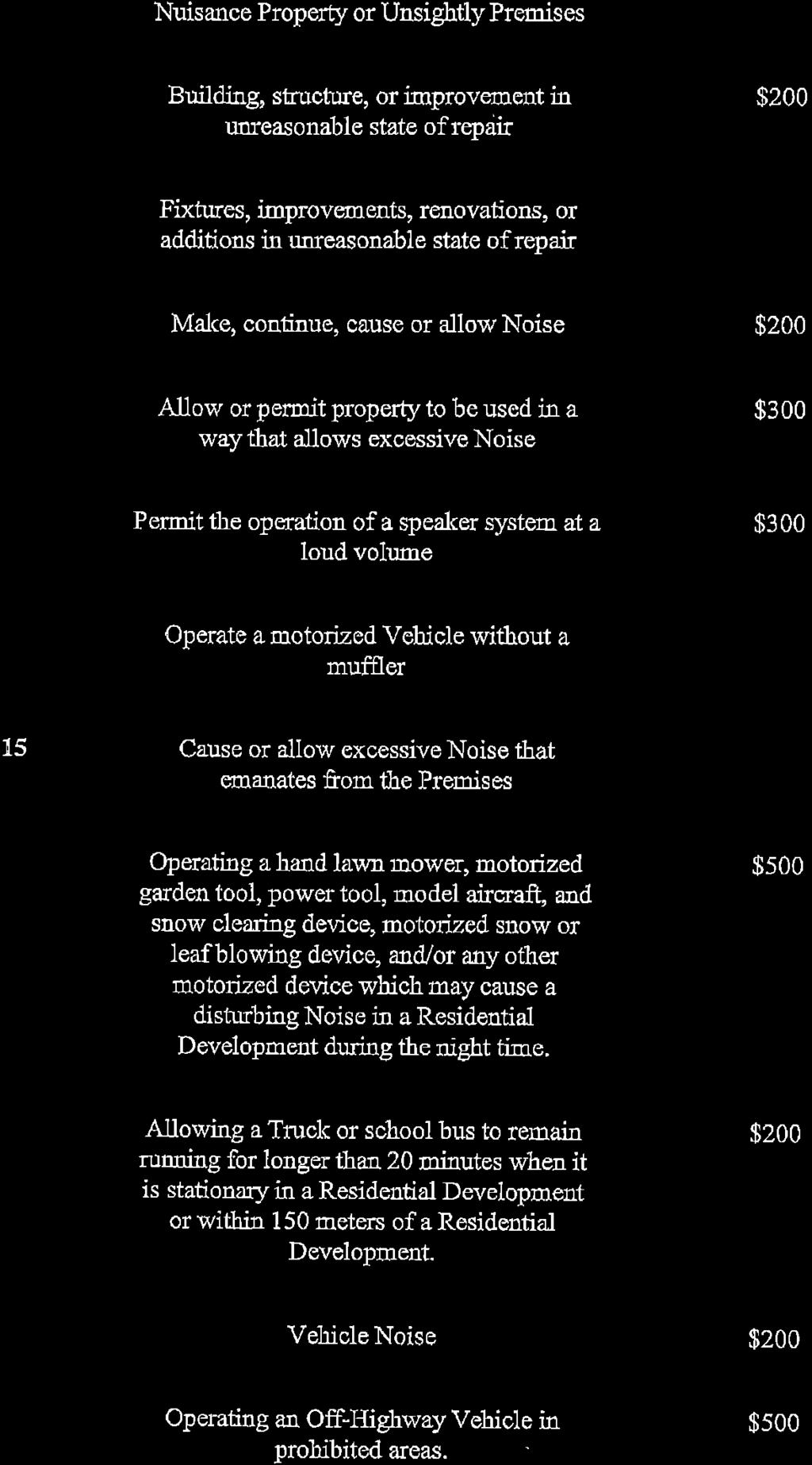
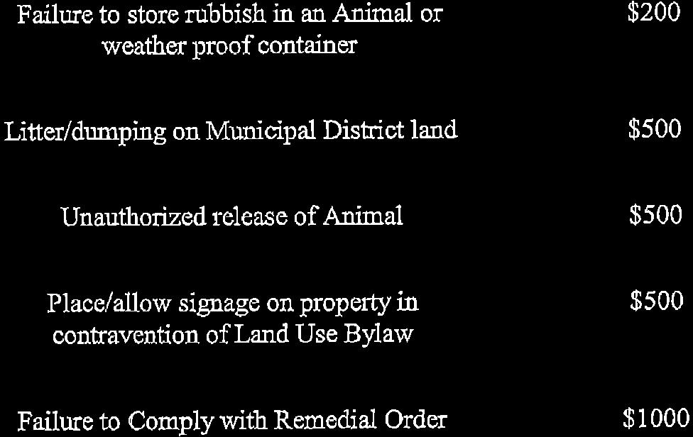
13 Municipal District of Foothills No Land Use Bylaw APPENDIX D Specified Penalties for Offences Table A - Specified Penalties For Offences Section Description of Offence Specified Penalty (a) Fail to comply with remedial order $ (b) Fail to comply with order to remedy $ (c) Fail to comply with stop order $ (d) (a) (b) (c) (d) (e) (f) (g) (h) (i) (j) (k) Obstruct/interfere with Designated Officer/Community Peace Officer/Bylaw Enforcement Officer in execution of their duties Erect/place/affix/locate, or allow any person to erect/place/affix/locate a sign that obstructs visibility at roadway intersections Erect/place/affix/locate, or allow any person to erect/place/affix/locate a sign on/affixed to private property without the consent of owner Erect/place/affix/locate, or allow any person to erect/place/affix/locate a sign not compliant with Dark Sky Bylaw Erect/place/affix/locate, or allow any person to erect/place/affix/locate an animated or illuminated sign without approval Erect/place/affix/locate, or allow any person to erect/place/affix/locate a temporary sign exceeding 14 days at location Erect/place/affix/locate, or allow any person to erect/place/affix/locate a sign not complying with setback requirements Erect/place/affix/locate, or allow any person to erect/place/affix/locate a sign located within 300 m. from limit of controlled highway without permit Erect/place/affix/locate, or allow any person to erect/place/affix/locate a sign located within 800 m. from centre point of intersection of a controlled highway/another highway/public roadway without permit Erect/place/affix/locate, or allow any person to erect/place/affix/locate a sign requiring a development permit without permit Erect/place/affix/locate, or allow any person to erect/place/affix/locate a prohibited sign Erect/place/affix/locate, or allow any person to erect/place/affix/locate a non-compliant sign $ $ $ $ $ $ $ $ $ $ $ $ Page 0

14
15
16
17
18

19
20
21

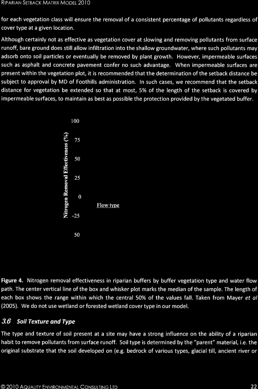
22
23
24
25
26
27
28
29

30
31
32
33

34

35
36

37


38

39
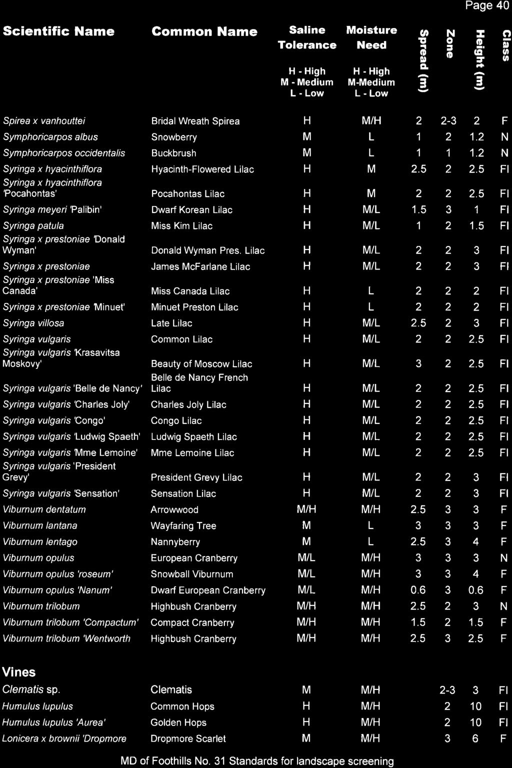
40
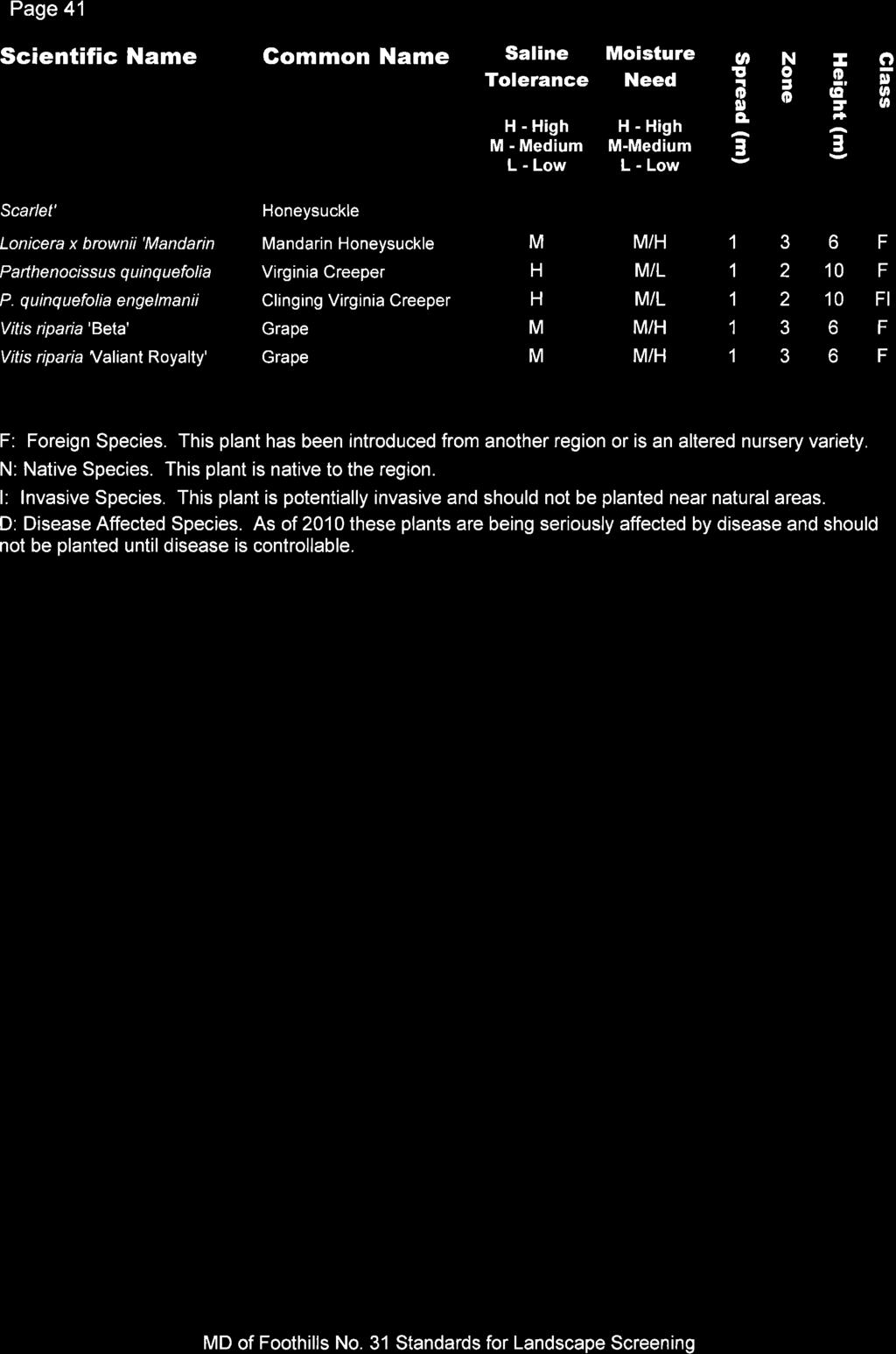
41
42
43

44

45
46

47
48

49
50
51
52
53
54
55
56
57
58
59

60
61

62
63
64
65
66
67
68
69

70

71
72
73
74
75
76
77
78
79
80
81
82
83
84
85
86

87
88
89
90
91
92
93
94

95
96
97
98
99
100
101
102
103
104

105
106

107
108
109
110

111
112
113
114
115
116

117
118

119
120
121

122
123
124

125
126
127
128
129

130
131
132
133
134
135
136
137
138
139
140
141
142
143
144
145
146
147
148
149
150
151
152
153
154
155
156

157
158
159
160
161
162
163
164

165
166
167

168
Guide to Preliminary Plans
 Guide to Preliminary Plans Introduction The Douglas County is committed to providing open, transparent application processes to the public. This Guide is provided to assist anyone interested in the procedures
Wapiti Ridge Estates Area Structure Plan SE W5M. December Prepared For:
 SE 13-20-1 W5M December 2000 Prepared For: 393494 Alberta Limited, and The Municipal District of Foothills No. 31 Prepared By: Kristi Beunder Professional Planning Services Calgary, Alberta Ph: 201-3309
A Guide to the Municipal Planning Process in Saskatchewan
 A Guide to the Municipal Planning Process in Saskatchewan A look at the municipal development permit and the subdivision approval process in Saskatchewan May 2008 Prepared By: Community Planning Branch
Conceptual Scheme SE W4
 December 2012 1. PURPOSE 1.1. The purpose of a Conceptual Scheme (CS) is as follows: a) To provide a framework for the subsequent subdivision and/or development of land within the Country Residential Policy
ALC Bylaw Reviews. A Guide for Local Governments
 2018 ALC Bylaw Reviews A Guide for Local Governments ALC Bylaw Reviews A Guide for Local Governments This version published on: August 14, 2018 Published by: Agricultural Land Commission #201-4940 Canada
Preliminary Subdivision Application (Major) (Four (4) lots or more)
 (Four (4) lots or more)") Gunnison City Offices www.gunnisoncity.org 38 West Center Gunnison, Utah 84634 (435) 528 7969 Date of Application: Preliminary Subdivision Application (Major) (Four (4) lots or more) APPLICANT INFORMATION
Gunnison City Offices www.gunnisoncity.org 38 West Center Gunnison, Utah 84634 (435) 528 7969 Date of Application: Preliminary Subdivision Application (Major) (Four (4) lots or more) APPLICANT INFORMATION
This is a conditional use permit request to establish a commercial wind energy conversion system.
 Public Works 600 Scott Boulevard South Hutchinson, Kansas 67505 620-694-2976 Road & Bridge Planning & Zoning Noxious Weed Utilities Date: March 28, 2019 To: From: Reno County Planning Commission Russ Ewy,
Guide to Combined Preliminary and Final Plats
 Guide to Combined Preliminary and Final Plats Introduction The Douglas County is committed to providing open, transparent application processes to the public. This Guide is provided to assist anyone interested
LAND USE BYLAW NO SEPTEMBER 2017
 LAND USE BYLAW NO. 397 17 SEPTEMBER 2017 Prepared by TABLE OF CONTENTS ADMINISTRATION GENERAL Section 1 Title... Administration 1 Section 2 Purpose... Administration 1 Section 3 Effective Date... Administration
MUNICIPAL DISTRICT OF ROCKY VIEW NO. 44 ELBOW VALLEY WEST DIRECT CONTROL DISTRICT BYLAW C
 This document has been consolidated for convenience only. A current listing of any and all amendments can be obtained from the Municpal District Office Bylaw No. Date of Approval Amendment Type Bylaw C-6042-2005
Preliminary Subdivision Application (Minor) (Three (3) lots or less)
 (Three (3) lots or less)") Gunnison City Offices www.gunnisoncity.org 38 West Center Gunnison, Utah 84634 (435) 528 7969 Date of Application: Preliminary Subdivision Application (Minor) (Three (3) lots or less) APPLICANT INFORMATION
Gunnison City Offices www.gunnisoncity.org 38 West Center Gunnison, Utah 84634 (435) 528 7969 Date of Application: Preliminary Subdivision Application (Minor) (Three (3) lots or less) APPLICANT INFORMATION
AS YOUR COMMUNITY EVOLVES, SO DOES OUR SUPPORT.
 AS YOUR COMMUNITY EVOLVES, SO DOES OUR SUPPORT. The Amended, Modernized and About to be Strengthened, Municipal Government Act A Presentation to CPAA Conference May 2017 Presented by: MUNICIPAL Charlotte
Village of Barons LAND USE BYLAW NO January Consolidated to Bylaw No. 710, October 2018
 Village of Barons LAND USE BYLAW NO. 677 January 2013 Consolidated to Bylaw No. 710, October 2018 Prepared by. January 2013 Village of Barons Land Use Bylaw No. 677 Amendments Bylaw No. Amendment Description
APPLICATION PROCEDURE
 ANTRIM PLANNING BOARD P. O. Box 517 Antrim, New Hampshire 03440 Phone: 603-588-6785 FAX: 603-588-2969 APPLICATION FORM AND CHECKLIST FOR MINOR OR MAJOR SITE PLAN REVIEW File Date Received By APPLICATION
5. That the Owner shall agree that all development Blocks shown within the Draft Plan will be connected to full municipal services.
 Conditions Relating to Draft Plan of Subdivision Approval East Fonthill 26T 01014 (Draft Plan dated December 1, 2013, and revised August 28, 2014), the Town of Pelham 1. This approval applies to the Draft
Strathcona County Municipal Policy Handbook. Last Review Date: May 21, 2013 Next Review Date: 05/2016
 SER-008-019 Strathcona County Municipal Policy Handbook Conceptual Schemes Date of Approval by Council: 09/28/04; 05/08/2007; 05/21/2013 Resolution No: 786/2004; 386/2007; 314/2013 Lead Role: Chief Commissioner
MUNICIPAL DEVELOPMENT PLAN
 MUNICIPAL DEVELOPMENT PLAN Prepared by: The Council and Planning and Development Services Bylaw No. 1414-09 adopted August 12, 2009 Amending Bylaw - 1480-12 adopted June 12, 2013 Amending Bylaw 1529-14
Prt. NE W5. Prepared for: Municipal District of Foothills #31. Prepared by:
 Prt. NE 22-22-3-W5 Prepared for: Municipal District of Foothills #31 Prepared by: Bowwood Land Services Inc. R.R. 1, Dewinton, Alberta T0L 0X0 Tel: 403-995-2225 Fax: 403-938-4787 " OFFICIAL COPY " ADOPTED
Residential Minor Subdivision Review Checklist
 Residential Minor Subdivision Review Checklist Plan Submittal Requirements: 2 full sets of stamped plans Electric submittal - all plans contained in a single PDF 3 full sets if commercial kitchen or dining
Telecommunications Development Permit Application Package
 Telecommunications Development Permit Application Package POLICY POL#308 Title: Policy Guidelines to Evaluate Commercial Communications Facilities Legal References: Radio Communication Act Municipal Government
Guide to Minor Developments
 Guide to Minor Developments Introduction The Douglas County (DCD) is committed to providing open, transparent application processes to the public. This Guide is provided to assist anyone interested in
REGIONAL DISTRICT OF NORTH OKANAGAN SUBDIVISION SERVICING BYLAW NO. 2600, 2013
 REGIONAL DISTRICT OF NORTH OKANAGAN SUBDIVISION SERVICING BYLAW NO. 2600, 2013 Page 3 TABLE OF CONTENTS SECTION -100- SCOPE AND APPLICABILTY... 4 101 Title... 4 102 Application... 4 103 Compliance with
Town of Shelburne, Vermont
 Town of Shelburne, Vermont CHARTERED 1763 P.O. BOX 88 5420 SHELBURNE ROAD SHELBURNE, VT 05482 www.shelburnevt.org 802-985-5118 * * Also available in alternate formats in accordance with the Americans With
UPPER MOUNT BETHEL TOWNSHIP NORTHAMPTON COUNTY, PENNSYLVANIA
 UPPER MOUNT BETHEL TOWNSHIP NORTHAMPTON COUNTY, PENNSYLVANIA JOINDER DEED / LOT CONSOLIDATION TOWNSHIP REVIEW PROCESS When accepting proposed Joinder Deeds / Lot Consolidations, review the Joinder Deed
Residential Major Subdivision Review Checklist
 Residential Major Subdivision Review Checklist Plan Submittal Requirements: 2 full sets of stamped plans Electric submittal - all plans contained in a single PDF 3 full sets if commercial kitchen or dining
CHAPTER 22 SUBDIVISION AND LAND DEVELOPMENT
 CHAPTER 22 SUBDIVISION AND LAND DEVELOPMENT 22-101. Title 22-102. Legislative Intent Part 1 General Provisions 22-201. Development Permits Part 2 Administration 22-301. Fee Schedule Part 3 Fee Schedule
RESIDENTIAL AND RECREATIONAL
 Energy, Mines & Resources Land Management Branch 320-300 Main Street Whitehorse, Yukon Y1A 2B5 667-5215 Fax 667-3214 www.emr.gov.yk.ca RESIDENTIAL AND RECREATIONAL Lot Enlargement Policy OBJECTIVE To facilitate
RURAL MUNICIPALITY OF CORMAN PARK NO Zoning Bylaw
 RURAL MUNICIPALITY OF CORMAN PARK NO. 344 Zoning Bylaw CONSOLIDATED November 5, 2014 - 2 - Table of Contents SECTION 1 - INTRODUCTION... 3 SECTION 2 - ADMINISTRATION... 4 SECTION 3 - GENERAL REGULATIONS...
Non-Medical Cannabis Retail Stores Application Form
 Development Services City of West Kelowna 2760 Cameron Road West Kelowna, BC V1Z 2T6 Phone: 778-797-8830 Fax: 778-797-1001 Non-Medical Cannabis Retail Stores Application Form An application for a non-medical
Greenfield Development Requirements
 Greenfield Development Requirements Planning & Engineering Department City of Yorkton Saskatchewan 2014 Summary Greenfield Development refers to the development of raw land to a finished state as residential,
STAFF REPORT. Financial Impact Statement There are no immediate financial impacts associated with the adoption of this report.
 STAFF REPORT Planning and Development Department Subject: Cottage Country Unsubstantial Amendment to Development Agreement To: CAO for Planning Advisory Committee, December 13, 2016 Date Prepared: December
COMPLETE AND SIGN LAND USE AMENDMENT APPLICATION FORM (attached) MUNICIPAL DISTRICT OF GREENVIEW NO. 16
 MUNICIPAL DISTRICT OF GREENVIEW NO. 16") LAND USE AMENDMENT APPLICATION PACKAGE Municipal District of Greenview 4806 36 Avenue, Box 1079, Valleyview AB T0H 3N0 T 780.524.7600 F 780.524.4307 Toll Free 1.866.524.7608 www.mdgreenview.ab.ca COMPLETE
LAND USE AMENDMENT APPLICATION PACKAGE Municipal District of Greenview 4806 36 Avenue, Box 1079, Valleyview AB T0H 3N0 T 780.524.7600 F 780.524.4307 Toll Free 1.866.524.7608 www.mdgreenview.ab.ca COMPLETE
PLANNING SERVICES FORM 3.3 SUBDIVISION APPLICATION COMMERCIAL OR BUSINESS PURPOSES
 FOR OFFICE USE ONLY Date of Receipt File Number Fee Submitted SUBDIVISION APPLICATION COMMERCIAL OR BUSINESS PURPOSES Accepted by Please note that the information provided in these forms is crucial to
PRELIMINARY PLAT CHECK LIST
 PRELIMINARY PLAT CHECK LIST Name of Proposed Subdivision: The following items must be included with the initial submittal of a Preliminary Plat: Application, filled out completely Project Narrative Pre-application
Larimer County Planning Dept. Procedural Guide for 1041 PERMITS
 - Larimer County Planning Dept. Procedural Guide for 1041 PERMITS PLEASE NOTE: A PRE-APPLICATION CONFERENCE IS REQUIRED PRIOR TO SUBMITTING THIS APPLICATION. PURPOSE: State Statutes allow local governments
CHAPTER XVIII SITE PLAN REVIEW
 CHAPTER XVIII SITE PLAN REVIEW Section 18.1 Section 18.2 Description and Purpose. The purpose of this chapter is to provide standards and procedures under which applicants would submit, and the Township
TENTATIVE PARCEL MAP APPLICATION GUIDE TENTATIVE PARCEL MAP APPLICATION REQUIREMENTS
 TENTATIVE PARCEL MAP APPLICATION GUIDE SISKIYOU COUNTY PLANNING DIVISION 806 South Main Street, Yreka CA 96097 Phone: (530) 841-2100 / Fax: (530) 841-4076 TENTATIVE PARCEL MAP APPLICATION REQUIREMENTS
SUBDIVISION APPLICATION
 PLANNING AND DEVELOPMENT SERVICES 38106 Rge Rd 275, Red Deer County, AB T4S-2L9 Phone: (403) 350-2170 Fax: (403) 346-9840 For Office Use Only File # Roll # Fee Submitted Date Deemed Complete Reference
MIDWAY CITY Municipal Code
 MIDWAY CITY Municipal Code TITLE 9 ANNEXATION CHAPTER 9.01 PURPOSE CHAPTER 9.02 GENERAL REQUIREMENTS CHAPTER 9.03 PROPERTY OWNER INITIATION OF ANNEXATION CHAPTER 9.04 PROCEDURES FOR CONSIDERATION OF PETITION
CHAPTER 3 PRELIMINARY PLAT
 10-3-1 10-3-3 SECTION: CHAPTER 3 PRELIMINARY PLAT 10-3-1: Consultation 10-3-2: Filing 10-3-3: Requirements 10-3-4: Approval 10-3-5: Time Limitation 10-3-6: Grading Limitation 10-3-1: CONSULTATION: Each
I. Requirements for All Applications. C D W
 108-16.1. Application checklists. Checklist for Required Submissions to the Planning Board or Zoning Board of Adjustment of Monroe Township All required submissions are to be made to the Administrative
RURAL GENERAL RG 1. PERMITTED USES DISCRETIONARY USES
 RURAL GENERAL RG PURPOSE: To protect the agricultural land base of the municipality while allowing nonagricultural developments which complement the area's economy. 1. PERMITTED USES DISCRETIONARY USES
APPLICATION SUBMITTAL REQUIREMENTS FOR Tentative Parcel or Subdivision Maps
 CITY OF EL CERRITO Community Development Department Planning and Building Division 10890 San Pablo Avenue, El Cerrito, CA 94530 (510) 215-4330 FA (510) 233-5401 planning@ci.el-cerrito.ca.us APPLICATION
Chapter 136. SOIL EROSION
 1 of 8 12/19/2011 4:17 PM Township of Andover, NJ Monday, December 19, 2011 Chapter 136. SOIL EROSION [HISTORY: Adopted by the Township Committee of the Township of Andover by Ord. No. 77-11 (Ch. XVII
Riverton Properties Ltd Proposed Special Housing Area
 Riverton Properties Ltd Proposed Special Housing Area Housing Accords and Special Housing Areas Act 2013 Expression of Interest 1 This Expression of Interest is made on behalf of Riverton Properties Ltd,
Section 12A Purpose of Subdivision Provisions
 Section 12A 12A Purpose of Subdivision Provisions Subdivision is primarily about creating land parcels that define and redefine property rights and, in most instances, the creation of new parcels of land
EXCERPTS FROM HALIFAX REGIONAL MUNICIPALITY CHARTER
 EXCERPTS FROM HALIFAX REGIONAL MUNICIPALITY CHARTER Municipal planning strategy 227 The Council may adopt a municipal planning strategy for all, or part, of the Municipality and there may be separate strategies
SITE DEVELOPMENT PLAN REQUIREMENTS CHECKLIST
 SITE DEVELOPMENT PLAN REQUIREMENTS CHECKLIST Completed DRC Application for Review Required for Application Process DRC Processing Fee 1 Commercial $2,500.00 Fire Department Review Fee 150.00 Total $2,650.00
PLANNING PROCEDURES AND FEES BYLAW
 PLANNING PROCEDURES AND FEES BYLAW The following is a consolidated copy of the planning procedures and fees bylaw and includes the following bylaws: Bylaw No. Bylaw Name Adopted Purpose 328 Comox Valley
Town of Lisbon, Maine SUBDIVISION REVIEW APPLICATION
 Date Received: Fee Paid (amount): Applicant: Town of Lisbon, Maine SUBDIVISION REVIEW APPLICATION Subdivision Name/Title: This application must be received at the Town Office by close of business on the
CITY OF VAUGHAN POLICY AND PROCEDURES FOR DEALING WITH CONTAMINATED OR POTENTIALLY CONTAMINATED SITES
 CITY OF VAUGHAN POLICY AND PROCEDURES FOR DEALING WITH CONTAMINATED OR POTENTIALLY CONTAMINATED SITES MAY 2001 This Report should be read in conjunction with the City of Vaughan BACKGROUND REPORT ON POLICY
Conceptual Scheme SE W4
 Conceptual Scheme September 2014 Conceptual Scheme 1. PURPOSE 1.1. The purpose of a Conceptual Scheme (CS) is as follows: a) To provide a framework for the subsequent subdivision and/or development of
COUNTY OF BRANT DEVELOPMENT SERVICES DEPARTMENT COMMITTEE OF ADJUSTMENT. Chair and Members of the Committee of Adjustment
 COUNTY OF BRANT DEVELOPMENT SERVICES DEPARTMENT COMMITTEE OF ADJUSTMENT TO: FROM: Chair and Members of the Committee of Adjustment Ruchika Angrish, Senior Planner DATE: January 23, 2014 REPORT: CA-14-06
DOUGLAS COUNTY SUBDIVISION RESOLUTION Article 4 Preliminary Plan 10/13/2015
 ARTICLE 4 PRELIMINARY PLAN 401 Intent An in-depth analysis of the proposed subdivision, including a review of the design considering the ability to obtain water and sanitation, identified geologic hazards,
Corman Park - Saskatoon Planning District Official Community Plan
 1 Corman Park - Saskatoon Planning District Official Community Plan CONSOLIDATED: October, 2017 2 Table of Contents Bylaw Amendments... 3 Section 1: Foundations... 4 Section 2: Future Growth Sector Objectives
TOWN OF WHITBY REPORT RECOMMENDATION REPORT
 TOWN OF WHITBY REPORT RECOMMENDATION REPORT REPORT TO: Planning and Development Committee REPORT NO: PL 4-08 DATE OF MEETING: January 21, 2008 FILE NO(S): MI-01-07 (SW- 2002-03) PREPARED BY: Planning Department
ARTICLE 7. SPECIFIC USE STANDARDS
 ARTICLE 7. SPECIFIC USE STANDARDS Section 7.1 Applicability The following standards apply to specified uses in all zoning districts in which such uses are allowed. Section 7.2 Accessory Apartments (A)
SMOKY LAKE COUNTY. Alberta Provincial Statutes. To provide a process to close a Government Road Allowance, or cancel a surveyed Road Plan.
 SMOKY LAKE COUNTY Title: Road Closure or Cancellation Policy No.: 16-03 Section: 03 Page No.: 1 of 11 E Legislation Reference: Alberta Provincial Statutes Purpose: To provide a process to close a Government
CHAPTER 3 PERMITS, PLANS AND ANNEXATION
 CHAPTER 3 PERMITS, PLANS AND ANNEXATION SECTION: 10-3-1: General Regulations 10-3-2: Building Permit 10-3-3: Plans 10-3-4: Certificate of Compliance and Occupancy 10-3-5: Conditional Use Permits 10-3-6:
Planning and Building Department
 Page 1 of Report PB-83-13 TO: Development and Infrastructure Committee Planning and Building Department SUBJECT: OP & Rezoning 5001 Corporate Drive Appleby Gardens LJM Developers Report Number: PB-83-13
Waseca County Planning and Zoning Office
 Waseca County Planning and Zoning Office 300 North State Street Waseca, Minnesota 56093 Phone: 507-835-0650 Fax: 507-837-5310 Form no. PZ 081009 Web Site: www.co.waseca.mn.us FEES: 1) CUP FEE- $400.00
DEPARTMENT OF PLANNING SERVICES 1555 N 17 th Ave Greeley CO Phone (970) Fax (970)
 Fax (970)") DEPARTMENT OF PLANNING SERVICES 1555 N 17 th Ave Greeley CO 80631 Phone (970) 400-6100 Fax (970) 304-6498 SITE SPECIFIC DEVELOPMENT PLAN USE BY SPECIAL REVIEW PROCEDURAL GUIDE SOLID WASTE DISPOSAL SITES
DEPARTMENT OF PLANNING SERVICES 1555 N 17 th Ave Greeley CO 80631 Phone (970) 400-6100 Fax (970) 304-6498 SITE SPECIFIC DEVELOPMENT PLAN USE BY SPECIAL REVIEW PROCEDURAL GUIDE SOLID WASTE DISPOSAL SITES
PLACEMENT OF SECURITY HUTS ON CITY OWNED LAND
 PLACEMENT OF SECURITY HUTS ON CITY OWNED LAND Policy No: 17957 Approved by Council 29 May 2014 C 39/05/14 Contents 1. Definitions 2. Problem Statement 3. Desired Outcomes 4. Strategic Intent 5. Role Players
A.3. ARTICLE 7 PLAN REQUIREMENTS FOR MINOR SUBDIVISION AND/OR LAND DEVELOPMENT
 700. 701.A.3. ARTICLE 7 PLAN REQUIREMENTS FOR MINOR SUBDIVISION AND/OR LAND DEVELOPMENT SECTION 700 PURPOSE The purpose of this Article is to set forth a streamlined set of Plan Requirements for minor
18 Sale and Other Disposition of Regional Lands Policy
 Clause 18 in Report No. 7 of Committee of the Whole was adopted, without amendment, by the Council of The Regional Municipality of York at its meeting held on April 19, 2018. 18 Sale and Other Disposition
SUBDIVISION AND DEVELOPMENT APPEAL BOARD PARKLAND COUNTY. DATE: May 29, 2018 FILE NO.: 18-S-003
 SUBDIVISION AND DEVELOPMENT APPEAL BOARD PARKLAND COUNTY Legislative Services Parkland County Centre 53109A HWY 779 Parkland County, AB T7Z 1R1 Telephone: (780) 968-3234 Fax: (780) 968-8413 DATE: May 29,
STAFF REPORT. March 14, Toronto and East York Community Council. Director, Community Planning, South District
 STAFF REPORT March 14, 2005 To: From: Subject: Toronto and East York Community Council Director, Community Planning, South District Preliminary Report Official Plan Amendment and Rezoning Application 05
CHAPTER 10 Planned Unit Development Zoning Districts
 CHAPTER 10 Planned Unit Development Zoning Districts Section 10.1 Intent and Purpose The Planned Unit Development (PUD) districts are intended to offer design flexibility for projects that further the
City of East Orange. Department of Policy, Planning and Development LAND USE APPLICATION & SITE PLAN REVIEW CHECKLIST
 Department of Policy, Planning and Development LAND USE APPLICATION & SITE PLAN REVIEW CHECKLIST COMPLETE: Applicant Information: Type of Proposal: OFFICE USE ONLY: New Residential Case #: Date: New Accessory
Lorne and Leanne Read Sundance Trail Phase II Area Structure Plan Amendment
 A SPRING 2008 CO-14264 Municipal District of Foothills No. 31 Lorne and Leanne Read Sundance Trail Phase II Area Structure Plan Amendment Lorne and Leanne Read SUNDANCE TRAIL AREA STRUCTURE PLAN - AMENDMENT
ENVIRONMENTAL ASSESSMENT / INFRASTRUCTURE PROJECTS
 Mailing Address: 5 Shoreham Drive, Downsview, ON M3N 1S4 Office location: 101 Exchange Avenue, Vaughan, ON L4K 5R6 Tel: 416-661-6600 Fax: 416-661-6898 www.trca.ca ENVIRONMENTAL ASSESSMENT / INFRASTRUCTURE
Guide to Replats. Step 1. Step 2. Step 3. Step 4. Step 5. Step 6. Step 7. Step 8. Step 9. Step 10
 Guide to Replats Introduction Douglas County is committed to providing open, transparent application processes to the public. This Guide is provided to assist anyone interested in the procedures and expectations
DEVELOPMENT PERMIT APPLICATION REQUIREMENTS
 DEVELOPMENT PERMIT APPLICATION REQUIREMENTS Where a parcel is designated within a development permit area (DPA) by an official community plan and a proposed development is not exempt from the DPA guidelines,
ADUs and You! Common types of ADUs include mother-in-law suite, garage apartments and finished basements.
 ADUs and You! Accessory Dwelling Units Town of Lyons Accessory Dwelling Units (ADUs) are a form of housing that can be an important tool for diversifying and increasing the local housing stock. Lyons lost
ARTICLE VII. NONCONFORMITIES. Section 700. Purpose.
 ARTICLE VII. NONCONFORMITIES. Section 700. Purpose. The purpose of this chapter is to regulate and limit the development and continued existence of legal uses, structures, lots, and signs established either
REPRESENTATIVE: Centerline Solutions Table Mountain Parkway Golden, CO 80403
 COMMISSIONERS: DARRYL GLENN (PRESIDENT) MARK WALLER (PRESIDENT PRO TEMPORE) STAN VANDERWERF LONGINOS GONZALEZ PEGGY LITTLETON PLANNING AND COMMUNITY DEVELOPMENT DEPARTMENT CRAIG DOSSEY, EXECUTIVE DIRECTOR
Financial Impact Statement There are no immediate financial impacts associated with the adoption of this report.
 STAFF REPORT Planning and Development Department Subject: Application by RYC Property to rezone a portion of lands on John Murray Dr. and Megan Lynn Dr. from R2 to R3 and to enter into a Development Agreement
YourCounty. YourPlan.
 YourCounty. YourPlan. MUNICIPAL DEVELOPMENT PLAN BYLAW NO. 09/12 SCHEDULE A Consolidated Version November 25, 2015 Note: All persons making use of the consolidation are reminded that it has no legislative
These can be obtained at the City s Engineering Department or on the City s website (
 Subdivision Application Guide This handout provides information on the requirements and processes for a subdivision of land. It is intended for general guidance only. Applicants should also refer to: Official
By-Law of The Corporation of the City of Oshawa
 By-Law 85-2006 of The Corporation of the City of Oshawa being a by-law to control the dumping of fill, removal of topsoil and alteration of grades. WHEREAS s. 142 of the Municipal Act, 2001, S.O. 2001,
Residential Subdivision Preliminary Plat Application
 WATER MODELING FEES Major : $650 or Minor : $550 # of lots x $35 per lot Residential Preliminary Plat Application Lots: 1-9 10-19 20-49 50-99 100-199 $300 $400 $475 $625 $825 200-349 350-499 500-499 700-999
In order to permit maximum applicability of the PUD District, PUD-1 and PUD-2 Districts are hereby created.
 ARTICLE III. PUD ned Unit Development Overlay District 205-128. Purpose. The PUD ned Unit Development Overlay District is intended to provide flexibility in the design of planned projects; to encourage
5.0 Permit Applications
 5.0 Permit Applications A primary objective of the Toronto and Region Conservation Authority () is to prevent the loss of life and property due to flooding and erosion. Accordingly, administers a natural
Staff Report for Council Public Meeting
 Agenda Item 3.3 Staff Report for Council Public Meeting Date of Meeting: September 27, 2017 Report Number: SRPRS.17.134 Department: Division: Subject: Planning and Regulatory Services Development Planning
PROPOSED TEXT CHANGES TO LAND USE BYLAW - JULY 2016
 SECTION # BRIEF SUMMARY OF CHANGE PROPOSED CHANGE CURRENT WORDING AMENDMENTS TO SECTION 2.5 - DEFINITIONS UTILITY SERVES (Both Major and Minor) Remove the word infrastructure from the definition title
North Qu Appelle No. 187 Bylaw Basic Planning Statement - Table of Contents
 - Table of Contents Section1 Introduction 2 Section 2 - The Rural Municipality of North Qu Appelle No. 187 3 Section 3 Municipal Goals.... 3 Section 4 Agriculture and Natural Resources.. 4 Section 5 Residential
Tentative Map Application Review Procedures
 FOR REFERENCE ONLY This page is not part of the application. Tentative Map Application Review Procedures The tentative map process in Churchill County is designed to provide a mechanism in order to divide
Subdivision - Application
 Planning and Development Services, 2001 Sherwood Drive, Sherwood Park, AB T8A 3W7 Phone 780-464-8080 Fax 780-464-8109 Email: Landuse&policyplanning@strathcona.ca (Page 1 of 5) This form is to be completed
Plans shall be drawn at a readable scale, signed, and sealed by a Florida Registered Engineer. The application package shall include:
 CHAPTER 400. SECTION 403. PERMIT TYPES AND APPLICATIONS SITE DEVELOPMENT 403.3. Preliminary Site Plans (PSP) A. Intent and Purpose PSPs are used to identify existing site conditions and demonstrate general
DRAFT PROPOSED CHAPTER 21 SPECIFIC PURPOSE - FLAT LAND RECOVERY ZONE
 DRAFT PROPOSED CHAPTER 21 SPECIFIC PURPOSE - FLAT LAND RECOVERY ZONE Note: The Specific Purpose (Flat Land Recovery) Zone is a "holding" zone that will be subject to a later plan change to confirm the
SUBDIVISION APPLICATION CHECKLIST SKETCH PLAN PRELIMINARY PLAT FINAL PLAT
 RECEIVED STAMP SUBDIVISION APPLICATION CHECKLIST SKETCH PLAN PRELIMINARY PLAT FINAL PLAT A checklist of background information and submission requirements for processing of a sketch plan, preliminary plat
Planning Rationale in Support of an Application for Plan of Subdivision and Zoning By-Law Amendment
 Planning Rationale in Support of an Application for Plan of Subdivision and Zoning By-Law Amendment The Kilmorie Development 21 Withrow Avenue City of Ottawa Prepared by: Holzman Consultants Inc. Land
A. ARTICLE 16 - STEEP SLOPE CONSERVATION DISTRICT
 1600. 1601.A. ARTICLE 16 - STEEP SLOPE CONSERVATION DISTRICT SECTION 1600 PURPOSE The purpose of this Article is to expand upon the Community Development Objectives associated with environmental protection
PLANNING REPORT. Prepared for: John Spaleta 159 Delatre Street Woodstock Ontario N4S 6C2
 PLANNING REPORT County Official Plan Amendment and Zoning By-law Amendment to Permit a Seasonal Dwelling on an Existing Lot of Record with Access onto a Seasonally Maintained Road Parts of Lot 29, Concession
SPECIAL USE PERMIT APPLICATION CHECKLIST BUCKINGHAM COUNTY OFFICE OF ZONING AND PLANNING MINUMUM SUBMISSION REQUIREMENTS
 SPECIAL USE PERMIT APPLICATION CHECKLIST BUCKINGHAM COUNTY OFFICE OF ZONING AND PLANNING MINUMUM SUBMISSION REQUIREMENTS The following table lists the information necessary to review a special use application.
8.5.1 R1, Single Detached Residential District
 8.5.1 R1, Single Detached Residential District The purpose of this district is to provide for residential development in the form of single detached dwellings. Dwelling, Single Detached Home Business,
RECOMMENDATION(S) OF THE CALGARY PLANNING COMMISSION
 OF THE CALGARY PLANNING COMMISSION") Page 1 of 11 EXECUTIVE SUMMARY This land use amendment application seeks to redesignate a single residential parcel from R-C1 to R-C1s to allow for a secondary suite. The site contains an existing secondary
Page 1 of 11 EXECUTIVE SUMMARY This land use amendment application seeks to redesignate a single residential parcel from R-C1 to R-C1s to allow for a secondary suite. The site contains an existing secondary
ARTICLE 9 SPECIFICATIONS FOR DOCUMENTS TO BE SUBMITTED
 ARTICLE 9 SPECIFICATIONS FOR DOCUMENTS TO BE SUBMITTED SECTION 950 GENERALLY All applications shall be properly signed and filed by the owner or, with the owner s specific written consent, a contract purchaser
TABLE OF CONTENTS 1. CITATION AREA OF APPLICATION PURPOSE DEFINITIONS GENERAL PROVISIONS Severability...
 FRASER VALLEY REGIONAL DISTRICT SUBDIVISION AND DEVELOPMENT SERVICING BYLAW No. 1319, 2015 TABLE OF CONTENTS 1. CITATION... 1 2. AREA OF APPLICATION... 1 3. PURPOSE... 1 4. DEFINITIONS... 2 5. GENERAL
Planning Justification Report
 Planning Justification Report, Township of Puslinch FARHI HOLDINGS CORPORATION Updated January 27, 2017 Zelinka Priamo Ltd. Page i TABLE OF CONTENTS Page No. 1.0 1.1 1.2 1.3 2.0 2.1 2.2 2.3 2.4 2.5 3.0