Downtown North CRA Expansion Area. Findings of Necessity Study
|
|
|
- Molly Shaw
- 5 years ago
- Views:
Transcription

1
2 Downtown North CRA Expansion Area Panama City, Florida Project # September 2018 Prepared for: City of Panama City Page ii
3 PANAMA CITY DOWNTOWN NORTH CRA EXPANSION AREA FINDINGS OF NECESSITY STUDY September 2018 TABLE OF CONTENTS Executive Summary... 1 Downtown North Historical Perspective... 2 Introduction... 4 Objectives and Purpose of the Redevelopment Act... 5 Redevelopment Area Expansion/Creation Procedures Declaration and Process Adoption of Findings of Necessity Report or Blight Study Redevelopment Plan Update... 7 Criteria for Determining Blight Alternative One Alternative Two... 9 Study Area Boundaries Study Area Conditions Observed Existing Conditions Summary Existing Land Use and Zoning Existing Land Use Future Land Use Zoning...21 Lot Layout and Parcel Value Lot Size Lot Value Lot Accessibility...28 Site Deterioration...28 Unsafe Condition of Housing Age of Housing Stock Unsanitary or Unsafe Conditions and Structure Deterioration...28 Page i
4 3. Transient Properties Vacant Lots and Substandard Buildings...31 Transportation Facilities Major Corridors Pedestrian Accommodations Bicycle Facilities Transit Services Vehicular Crashes and Calls for Emergency Fire/Medical Services...36 Aggregate Taxable Value Decline...38 Diversity of Ownership...44 Fire and Emergency Calls-for Service...44 Summary of Existing Conditions...45 Conclusion of Alternative Tests Legal Description of Expansion Area Page ii
5 LIST OF TABLES Table 1: Existing Land Use Table 2: Future Land Use Categories Table 3: Zoning Districts Table 4: Development Regulations and Standards Table 5: Comparative Changes in Taxable Values Table 6: FDOT Vehicular Crash Count from 2014 to Table 7: Slum and Blight Conditions Matrix LIST OF MAPS Map 1: Florida Master Site File Historic Structures in CRA Expansion Area... 3 Map 2: Boundaries of Existing CRA and Proposed Expansion Area Map 3: Existing Land Use Map Map 4: Future Land Use Map Map 5: Zoning Map Map 6: Parcel Lots Sizes in Square Feet Map 7: Parcel Taxable Values Map 8: Age of Structures Map 9: Vacant Parcels by Type Map 10: FDOT Crash Data Page iii
6 Executive Summary This report identifies the presence of several conditions of blight within the City of Downtown North, as defined by Section F.S., that justify the expansion of the Downtown North Community Redevelopment Area to include those parcels located within the Finding of Necessity Study Area. (See Map 2: Boundaries of Existing CRA and Proposed Expansion Area). Section ( 7 & 8) presents the three (3) conditions of Slum Area and the definitions of fifteen (15) Blight Conditions that may be used to determine if an area qualifies for inclusion in a Community Redevelopment Area. To be considered a slum or blighted, a minimum of two (2) of the eighteen (18) Slum and Blight Area conditions need to be observed within the Downtown North Study Area. The observance of five (5) of the fifteen (15) Blight Area conditions and one (1) of the three (3) conditions of a slum-area within the Study Area meets the criteria Alternative One method for determination of blight and justifies the inclusion of the Study Area within the existing Downtown North Community Redevelopment Area in accordance with Florida Statutes, Section 163, III. The conditions of blight identified and observed within the CRA expansion Study Area include: 1) Inadequate provision for ventilation, light, air, sanitation, or open spaces (Slum Area) 2) Aggregate assessed values of real property in the area for ad valorem tax purposes have failed to show any appreciable increase over the 5 years prior to the finding of such conditions (Condition of Blight) 3) Faulty lot layout, in relation to size, adequacy, accessibility, or usefulness (Condition of Blight) 4) Deterioration of site or other improvements (Condition of Blight) 5) Diversity of ownership or defective or unusual conditions of title which prevent the free alienability of land within the deteriorated or hazardous area (Condition of Blight) 6) Fire and emergency medical service calls higher than in the remainder of the municipality (Condition of Blight) Table 7, presents a summary checklist of the definitions associated with conditions of slum and blight. Based on the observed presence of these conditions within the Study Area, the City of Panama City may expand the boundaries of the existing Community Redevelopment Area to include the area within the CRA expansion Study Area boundaries in accordance with Section 163, Part III, Florida Statutes (F.S.), the Community Redevelopment Act. Page 1


7 Downtown North Historical Perspective The history of Panama City dates to the 1880s when real estate entrepreneurs L.M. Ware, F.M. Moates, R.M. Baker, G.W. Jenks, and the St. Andrews Bay Railroad, Land and Mining Company started marketing the area, known as Harrison at the time. In 1905, the Gulf Coast Development Company was formed and built railroad lines connecting the area to the rest of the state. G.M. West, a developer, was instrumental in naming the area Panama City in The City incorporated in Business gradually expanded into the 300 and 400 blocks of Harrison Avenue in the 1910s. The area to the north of Downtown, which includes the current Downtown North Redevelopment Area, also experienced significant growth in population. Following the creation of Bay County in 1913, Panama City was chosen to be the new county seat the following year. Expansion continued into the 1920s and 30s. By the late 1930s, the limits and shape of the downtown were firmly established, with business extending as far as the 700 block. In the 1930s and 1940s, the area witnessed an Figure 1. Downtown Panama City increase in entrepreneurial ventures that served the needs of local residents. The 1950s and 1960s, characterized by the civil rights movement in the entire nation, also witnessed the rise of civic movement in the community. It was during this period that two civic organizations the Negro Improvement Association and Women s Civic Club were established in the Glenwood community, both of which played a pivotal role in advancing the welfare of the African American community. The Downtown North redevelopment area is now home to Glenwood, Cove and the Jenks and Grace Avenue neighborhoods, and several institutional uses, including the Bay High School, A.D. Harris High School, Bay County Juvenile Courthouse, Bay County Juvenile Retention Center, the Life Management Center of Northwest Florida, African American Cultural Center, Bay Medical Center, and other faith-based institutions, non-profit organizations, educational institutions, and community facilities. The expansion area includes Bay High School (the current CRA boundary splits the school property), Bayside Church, several auto-oriented uses (mostly repair), warehouses and some residential. Several buildings in the expansion area have been surveyed and assessed for historic significance but were determined not to be significant for National Register designation (as individual resources or as part of a district). The surveys are filed with the Florida Master Site File. Page 2

8 Map 1: Florida Master Site File Historic Structures in CRA Expansion Area Page 3
9 Introduction This report provides the required findings of blight as identified in Section 163, Part III, Florida Statutes (F.S.), the Redevelopment Act, in order to enable the expansion of the existing Downtown North Community Redevelopment Area to include additional portions of the Panama City s Downtown North area. This is the first step in an on-going series of steps designed to stimulate economic development, enhance and improve existing communities and assist redevelopment activities within the Downtown North CRA. Page 4
10 Objectives and Purpose of the Redevelopment Act The purpose of the Community Redevelopment Act, Chapter 163, Part III of the Florida Statutes is to assist local governments in eliminating and/or preventing blighted conditions that are detrimental to the sustainability of economically and socially vibrant communities. The following paragraphs describe those blighted conditions, their specific effects, and the intentions of the community redevelopment regime as a tool for creating and implementing policies and programs. Section (1) It is hereby found and declared there exist in counties and municipalities of the state slum and blighted areas which constitute a serious and growing menace, injurious to the public health, safety, morals, and welfare of the residents of the state; that the existence of such areas contributes substantially and increasingly to the spread of disease and crime, constitutes an economic and social liability imposing onerous burdens which decrease the tax base and reduce tax revenues, substantially impairs or arrests sound growth, retards the provision of housing accommodations, aggravates traffic problems, and substantially hampers the elimination of traffic hazards and the improvement of traffic facilities; and that the prevention and elimination of slums and blight is a matter of state policy and state concern in order that the state and its counties and municipalities shall not continue to be endangered by areas which are focal centers of disease, promote juvenile delinquency, and consume an excessive proportion of its revenues because of the extra services required for police, fire, accident, hospitalization, and other forms of public protection, services, and facilities. Section (2) It is further found and declared that certain slum or blighted areas, or portions thereof, may require acquisition, clearance, and disposition subject to use restrictions, as provided in this part, since the prevailing condition of decay may make impracticable the reclamation of the area by conservation or rehabilitation; that other areas or portions thereof may, through the means provided in this part, be susceptible of conservation or rehabilitation in such a manner that the conditions and evils enumerated may be eliminated, remedied, or prevented; and that salvageable slum and blighted areas can be conserved and rehabilitated through appropriate public action as herein authorized and the cooperation and voluntary action of the owners and tenants of property in such areas. Section (3) It is further found and declared that the powers conferred by this part are for public uses and purposes for which public money may be expended and police power exercised, and the necessity in the public interest for the provisions herein enacted is declared as a matter of legislative determination. Section (4) It is further found that coastal resort and tourist areas or portions thereof which are deteriorating and economically distressed due to building density patterns, inadequate transportation and parking facilities, faulty lot layout, or inadequate street layout, could, through the means provided in this part, be revitalized and redeveloped in a manner that will vastly improve the economic and social conditions of the community. Section (5) It is further found and declared that the preservation or enhancement of the tax base from which a taxing authority realizes tax revenues is essential to its existence Page 5
11 and financial health; that the preservation and enhancement of such tax base is implicit in the purposes for which a taxing authority is established; that tax increment financing is an effective method of achieving such preservation and enhancement in areas in which such tax base is declining; that community redevelopment in such areas, when complete, will enhance such tax base and provide increased tax revenues to all affected taxing authorities, increasing their ability to accomplish their other respective purposes; and that the preservation and enhancement of the tax base in such areas through tax increment financing and the levying of taxes by such taxing authorities therefore and the appropriation of funds to a redevelopment trust fund bears a substantial relation to the purposes of such taxing authorities and is for their respective purposes and concerns. This subsection does not apply in any jurisdiction where the community redevelopment agency validated bonds as of April 30, Section (6) It is further found and declared that there exists in counties and municipalities of the state a severe shortage of housing affordable to residents of low or moderate income, including the elderly; that the existence of such condition affects the health, safety, and welfare of the residents of such counties and municipalities and retards their growth and economic and social development; and that the elimination or improvement of such condition is a proper matter of state policy and state concern and is for a valid and desirable public purpose. Section (7) It is further found and declared that the prevention or elimination of a slum area or blighted area as defined in this part and the preservation or enhancement of the tax base are not public uses or purposes for which private property may be taken by eminent domain and do not satisfy the public purpose requirement of s. 6(a), Art. X of the State Constitution. Redevelopment Area Expansion/Creation Procedures 1. Declaration and Process Determining if blight conditions exist within the Study Area is the initial step in ascertaining the expansion area s appropriateness as a community redevelopment area and inclusion in the Downtown North s current Community Redevelopment Area. This documentation of blight conditions and supporting analysis shall be referred to herein as the Findings Report. This report describes the physical, economic, and regulatory conditions within the community redevelopment Study Area that are associated with blight or its causes and discusses the need for a community redevelopment area. S&ME staff, working closely with CRA and City staff, inspected the Study Area through an on-site field study. In addition to the field study, a GIS analysis of conditions was conducted and will be presented in later sections of this report. Data was provided by the City of Panama City, Bay County GIS, and the Bay County Property Appraiser. S&ME utilized ESRI Business Analyst data to derive recent socio-economic data and prepared the analysis contained within this report. Page 6
12 2. Adoption of Findings of Necessity Report or Blight Study Under the Community Redevelopment Act, if an area is deemed blighted, a resolution must be adopted by the local governing body, or municipal subdivision, finding that blight conditions are present within the defined Study Area and that the repair, rehabilitation and/or the redevelopment of said areas are in the interest of public health, safety and welfare. If an area has such blighted conditions, the governing body would be empowered to establish a Community Redevelopment Agency (CRA). After the adoption of a Resolution by the Panama City Community Redevelopment Agency acknowledging the documented conditions of blight and expanding the Community Redevelopment Area boundaries, the Panama City Commission will adopt an Ordinance formally acknowledging the expanded Downtown North Community Redevelopment Area boundaries and the participating parcels. The ordinance will also establish the taxable-value base-year for the calculation of tax-increment (TIF) revenue, duration of the expansion area within the Downtown North CRA and also authorize the contribution of the TIF revenue collected from the expanded area s participating parcels for placement in the Downtown North Community Redevelopment Agency s Tax-Increment Trust fund. The most recent real property certified tax roll, prior to the effective year of the ordinance, shall be used to establish the base year. These taxable values within the expanded redevelopment area will be used to calculate the future tax increment. In the Downtown North s case, the assumed timetable to move forward implies that the calculation of the tax increment will utilize the 2017 certified rolls for the proposed expansion area. 3. Redevelopment Plan Update The Panama City Commission acts as the City s Community Redevelopment Agency. The Panama City Community Redevelopment Agency has directed the subsequent preparation of the Community Redevelopment Plan update which would reflect the expansion area s addition to the existing CRA s boundaries. The updated Community Redevelopment Plan will provide physical information on the expanded redevelopment area and identify potential programs and projects to address the specified blighted conditions. The Community Redevelopment Act requires that redevelopment plans be subjected to a compliance review that is conducted by the Planning Board before it may be submitted to the City Council for approval. The Planning Board has sixty (60) days to review the redevelopment plan for its conformity with the City s Comprehensive Development Plan, addressing the development of the City as a whole and providing comments to the Community Redevelopment Agency. After receiving comments and recommendations from the Planning Board, the local governing body shall hold a public hearing on the approval of the Community Redevelopment Plan after appropriate public notice has been provided and appropriate advertisements placed within the accepted general circulation newspaper of the area. Prior to the City adopting any resolution or ordinance to approve an updated community redevelopment plan or establish a redevelopment trust fund, the governing Page 7
13 body must provide public notice of the proposed actions to each of the taxing authorities that have the power to levy ad-valorem taxes within the redevelopment area. Such notices serve as an alert to these taxing authorities to any possible changes in their budgets that may occur as a result of the redevelopment action. As a policy matter, it is assumed that the following entities with ties and relationships to the City of Panama City government will receive notice of any actions arising from either the findings of necessity analysis or subsequent programs or initiatives should they be authorized under the terms of the Redevelopment Act. o Bay County Board of County Commissioners o Bay County Tax Collector o Northwest Florida Water Management District o Bay County Schools Public School System o Bay County Property Appraisers Office Criteria for Determining Blight The Community Redevelopment Act establishes two similar, but discrete, pathways to determine if a Study Area is a blighted area, sufficient to warrant the full application of the redevelopment powers conveyed by such a designation. Alternative One involves the layering of two tests. The first test is broadly conditional and the second test is criteria specific. Both tests must conclude that the described conditions exist affirmatively. Alternative Two involves a specific agreement among parties subject to a prospective trust fund agreement. Where such an agreement exists, the jurisdiction seeking to designate a redevelopment area will be allowed to pass a less rigorous test. As in the first alternative, this test relates to specific criteria and it must conclude affirmatively. 1. Alternative One The first test for Alternative One requires that a Study Area identified as a blighted area contain a substantial number of deteriorated or deteriorating structures, in which conditions, as indicated by government maintained statistics or other studies, are leading to economic distress or endanger life or property. The second test for Alternative One must prove that the area must be one in which two or more of the following factors are present. a. Predominance of defective or inadequate street layout, parking facilities, roadways, bridges, or public transportation facilities. b. Aggregate assessed values of real property in the area for ad valorem tax purposes have failed to show any appreciable increase over the 5 years prior to the finding of such conditions. c. Faulty lot layout in relation to size, adequacy, accessibility, or usefulness. d. Unsanitary or unsafe conditions. e. Deterioration of site or other improvements. f. Inadequate and outdated building density patterns. Page 8
14 g. Falling lease rates per square foot of office, commercial, or industrial space compared to the remainder of the county or municipality. h. Tax or special assessment delinquency exceeding the fair value of the land. i. Residential and commercial vacancy rates higher in the area than in the remainder of the county or municipality. j. Incidence of crime in the area higher than in the remainder of the county or municipality. k. Fire and emergency medical service calls to the area proportionately higher than in the remainder of the county or municipality. l. A greater number of violations of the Florida Building Code in the area than the number of violations recorded in the remainder of the county or municipality. m. Diversity of ownership or defective or unusual conditions of title which prevent the free alienability of land within the deteriorated or hazardous area. n. Governmentally owned property with adverse environmental conditions caused by a public or private entity. o. A substantial number or percentage of properties damaged by sinkhole activity which have not been adequately repaired or stabilized Alternative Two The Redevelopment Act also allows that a blighted area may be any area in which at least one of the factors identified in paragraphs (a) through (o) of Section (8), F.S. are present and all taxing authorities (as such term is defined in the Redevelopment Act) subject to Section (2)(a), F.S. agree, either by interlocal agreement or agreements with the agency or by resolution, that the area is blighted. 1 Florida Statutes, Section (8). Page 9
15 Study Area Boundaries The analysis in this report is limited to a specific geographic area of approximately 95 acres (or less than 1% of the city s acreage), including all right-of-way. The Study Area extends from the existing CRA and covers only properties within Panama City. Existing uses within the Study Area include single-family and multi-family housing, hotel and motel, a wide range of commercial uses, light industrial uses and warehousing, public uses, institutional uses, and vacant lands. The existing Downtown North Community Redevelopment Area (CRA) is serviced by major thoroughfares including: Harrison Avenue, Martin Luther King Boulevard (north and south) 15 th Street, and Highway 231 (east and west). The primary thoroughfares providing connections to and through the proposed expansion area include Harrison Avenue and 11 th Avenue. Other transportation modes include fixed route bus transit, bicycle lanes, and pedestrian facilities through the Study Area. Map 2 depicts the proposed expansion area boundaries, as well as the existing Downtown North Redevelopment Area boundaries. The geographic area of the existing Redevelopment Area is approximately 860 acres including right-of-way. The proposed expansion area will increase the size of the entire Downtown North Redevelopment Area to approximately 955 acres, including right-of-way (or approximately 4.2% of the city s 22,684 acres). The analysis contained in this report will focus on the land-based resources of the Study Area and its ability to generate economic return and local tax revenues. As a general matter, landbased resources that are in a state of physical decline, are underutilized, or are improperly deployed may significantly limit a local jurisdiction s ability to remain competitive in a larger economic context and may in the long term negatively affect the jurisdiction s overall financial condition and the level of services it can provide its residents. Local governments that are highly dependent upon ad-valorem tax revenues are the most vulnerable in these situations. Real property assets that are physically or functionally deteriorated or that do not meet today s contemporary development requirements are limited in their ability to generate their full potential (ad-valorem) of taxes. The physical character and utility of these real property assets, along with the services required to sustain them, are key factors in determining a community s economic health. This analysis utilizes tax roll data supplied by the Bay County Property Appraiser, City of Downtown North staff-supplied data, on-site visual inspections and site visits to properties within the Study Area. Page 10

16 Map 2: Boundaries of Existing CRA and Proposed Expansion Area Page 11
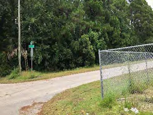
17 Study Area Conditions Observed The follow section of the report provides a brief description of the conditions observed within study area. Discussions with City and CRA Staff corroborated the observed conditions. The area is characterized by a mix of single-family and multi-family residential uses, light-industrial, vacant lots, and commercial development. Conditions of blight observed, through the field survey, within the proposed expansion area are: predominance of defective or inadequate street layout, parking facilities, roadways, bridges, or public transportation; unsanitary or unsafe conditions (lack of sidewalks, illegal storage facilities, inadequate stormwater facilities); deterioration of site or other improvements (faulty sidewalks, boarded-up houses, declining commercial structures). These conditions are documented on the following pages as a series of site photos. The predominance of defective or inadequate sidewalks, parking facilities, roadways, or public transportation facilities are indicative of a lack of public investment over multiple years. While recent streetscaping projects have initiated incremental improvements, a perceived lack of public investment in the public realm addressing transportation facilities shortcomings discourages private sector investment and limits development within affected areas. Reduced private sector investment over a multiple year period, within the affected area, translates to stagnating or decreasing property values, reduced economic activity, and a deterioration of existing private sector development. Page 12


18 Inadequate Transportation Facilities Transit facility with no amenities Utility poles in the middle of sidewalks Poor sidewalk maintenance Page 13


19 Unsanitary or Unsafe Conditions Dumping of trash and abandoned vehicle(s) Shipping container storage on residential lots Stagnant standing water, lack of adequate stormwater facilities and drainage Page 14


20 Deterioration of Site of Other Improvements: Faulty or Inadequate Sidewalks Page 15

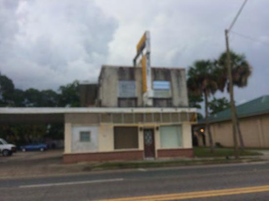
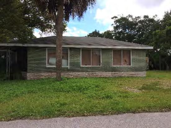
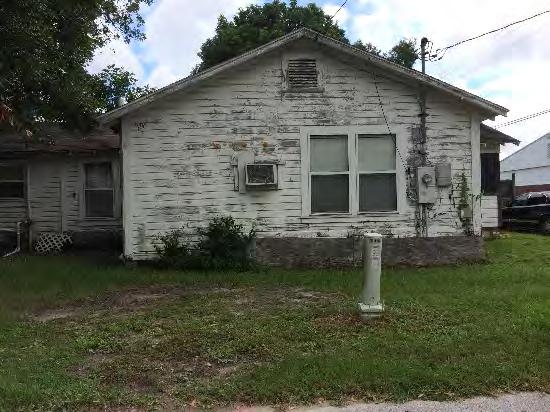


21 Deterioration of Site or Other Improvements: Commercial & Residential Deterioration Page 16
22 Existing Conditions Summary This section of the report documents the existing conditions within the overall proposed Downtown North CRA Expansion Area, including the condition of existing development, land uses, lot layout and parcel values, site deterioration, unsafe conditions of housing, transportation facilities, real estate development activity, diversity of ownership, and fire and emergency calls for service that could influence development or utilization of the community s land based resources. Existing Land Use and Zoning The 167 parcels identified within the Study Area are home to a range of existing land uses and include a total of 4 future land use categories and 7 zoning districts, within the City of Downtown North and in unincorporated Bay County. 1. Existing Land Use The predominant land use within the Study Area, based on total size, is light manufacturing, covering about 18 acres. These sites are not congregated in a particular area but are rather spread out from Entera Drive to McKenzie Avenue. There are two large manufacturing sites, one comprising 8 acres between Entera Drive and the railroad, and the other one with 4 acres at the corner of East 15th Street and McKenzie Avenue. The next two largest existing land uses are institutional (Bay High School and Bayside church) and services/commercial, covering approximately 15 acres and 14 acres, respectively. Single-family residential is also the most common use by parcel, with a count of 52 parcels, approximately one third of all parcels in the Study Area. Map 3 displays the existing land uses in the proposed expansion area. Table 1 presents the existing land use distribution. Table 1: Existing Land Use ELU Parcel Count Area Percent of Total Area Light Manufacturing % Office/Professional % Services/Commercial % Multifamily (10 units or less) % Single Family % Utilities % Vacant % Vacant City Owned % Institutional % Hotel and Motels % Total % Sources: Bay County Property Appraiser s Office; S&ME; Page 17

23 Map 3: Existing Land Use Map Sources: Bay County Property Appraiser s Office; S&ME; Page 18
24 2. Future Land Use The predominant future land use category within the Study Area, based on parcel count, is Mixed-Use, comprising 83 parcels. The next largest future land use categories are General Commercial with 60 parcels and Industry with 22. Public/Institutional accounts for only 2 parcels. In terms of acreage, the most predominant is General Commercial with approximately 29 acres, followed by Industry and Mixed-Use with 22 and 21 acres, respectively. Map 4 displays the future land use categories in the Study Area. Table 2: Future Land Use presents the distribution of the future land use categories. The General Commercial future land use category covers the sites along Harrison Avenue, Luverne Avenue and McKenzie Avenue. The central portion of the study area, where most of the homes are located, is designated Mixed-Use. The sites along the railroad right-ofway are designated Industry. Table 2: Future Land Use Categories Future Land Use Category Parcel Count Acreage General Commercial Industry Mixed Use Public/Institutional Grand Total Sources: Bay County Property Appraiser s Office; S&ME; Page 19

25 Map 4: Future Land Use Map Sources: Bay County Property Appraiser s Office; S&ME; Page 20
26 3. Zoning The predominant zoning districts within the Study Area, based on total size, are GC-2 (general Commercial-2) and LI (Light Industry), covering approximately 29 acres and 22 acres, respectively. The zoning district that is most predominant by parcel is MU-3 (Mixed- Use-3), with a count of 61 parcels, followed by GC-2. The primary purpose of the GC-2 district is to provide areas for intensive commercial activity including retail sales and services, wholesale sales, shopping centers, professional offices and services, and other similar land uses. The LI district provides for light industrial operations which have minimum nuisance attributes and do not cause excessive noise, smoke, pollutants, traffic by trucks or other similar characteristics normally associated with a heavy industrial operation or invite the storage of chemical or petroleum products. Table 1 presents the zoning district distributions. Table 4 summarizes the regulations and standards for the predominant zoning districts GC-2 and LI. Map 5 displays the zoning districts in the Study Area. Table 3: Zoning Districts Zoning Districts Parcel Count Acreage General Commercial-2 (GC-2) Light Industry (LI) Mixed-Use-3 (MU-3) Public/Institutional (PI) Mixed-Use-1 (MU-1) Mixed-Use-2 (MU-2) General Commercial-1 (GC-1) Grand Total Sources: Bay County Property Appraiser s Office; S&ME; Page 21
27 Table 4: Development Regulations and Standards Uses Allowed Floor Area Ratio (FAR) Maximum Density Impervious Area Ratio GC-2 LI MU-3 Office; personal services; child care; retail; printing, publishing; food establishments; athletic clubs, dance or music studios; vehicle dealers and repair shops; adult entertainment; wholesaling, warehousing and storage; commercial recreational facilities; public utilities with exception to solid waste facilities and landfills; and similar uses. Manufacturing and assembly; private and commercial marinas and marine facilities; business park; vocational trade and industrial education; public utilities. Mixture of two or more uses within the same development: Single-family; community residential homes; schools; private recreation; public utilities; family day care homes; attached dwellings; multifamily; neighborhood commercial; drivethrough facilities; retail business (1) du/a Maximum Height No maximum No maximum 65 Sources: City of Panama City (Municode); S&ME; (1) Warehouses defined as buildings with more than 90 percent of the area dedicated to storage or warehousing may have a 1.0 minimum floor area ratio. In no case shall the FAR of the site exceed 1.5 considering all structures. Page 22

28 Map 5: Zoning Map Sources: Bay County Property Appraiser s Office; S&ME; Page 23
29 Lot Layout and Parcel Value Faulty lot layout can have a tremendous impact on the value of property. If lot sizes do not meet zoning requirements, or do not meet standards for the current demands of the market, they will require aggregation in order to be economically viable for appropriate development. If commercial parcels are not adequately accessible and/or will not accommodate off-street parking on-site or in close proximity, they lose marketable value. Additionally, in older areas of the city, it is common for properties to be owned by estates or to be caught in the uncertainty of probate proceedings, which can significantly affect parcel aggregation. 1. Lot Size The parcels located within the CRA expansion area range in size from very small to several large parcels. The parcels in the expansion area are sized as follows: 6 parcels are greater than two (2) acres (4% of the total parcels) 157 parcels are less than one (1) acre (94% of the total parcels) 136 parcels are less than ½ an acre in size (81% of the total parcels) 80 parcels are less than ¼ of an acre in size (48% of the total parcels) Parcels that very small are frequently too small to redevelop individually and hinder the economic vitality and development potential of an area. Map 6, on the following page, shows the parcel areas within the expansion area. The large proportion of small to very small lot sizes limits the redevelopment options that may be accommodated on small sites and limits the future economic viability of the area. 2. Lot Value 2018 Tax assessments by the Bay County Property Appraiser show that the average median assessed value of residential parcels within the proposed CRA expansion area were significantly lower than the median assessed values of the City of Panama City and Bay County. The 2017 median residential assessed values in the expansion area were $65,649. The 2017 median residential assessed value in the Panama City was $177,005 and it was $184,450 in Bay County. This disparity in property values is also reflective of a comparative underutilization and lower level of investment for the parcels within the proposed CRA expansion area when compared to Panama City and Bay County. Underutilized parcels with lower development values can have a deleterious effect on the timely development of adjacent similarly low valued parcels. Table 5 compares the historic changes in taxable values for the parcels located within the CRA expansion Study Area, Panama City, and Bay County. In the past seven (7) years from 2010 to 2017, the taxable values of the parcels within the Study Area have declined 18.6%, while the taxable values of the parcels within Panama City and Bay County have increased by 3.7% and 2%, respectively. Page 24
30 Table 5: Comparative Changes in Taxable Values 2017 Taxable 2010 Taxable Change Values Values Proposed CRA Expansion $15,267,620 $18,490, % Panama City $2,102,914,979 $2,026,827, % Bay County $15,406,325,125 $15,103,996, % Source: Bay County Property Appraiser, 2010 & This disparity in taxable values is indicative of a blighted area that is suffering from a lack of private sector investments and commercial activity. Map 7 shows the taxable value of parcels within the expansion area. Page 25

31 Map 6: Parcel Lots Sizes in Square Feet Page 26

32 Map 7: Parcel Taxable Values Page 27
33 3. Lot Accessibility During field visits to the expansion Study Area the lack of uniform accessibility to lots and buildings was identified. The most frequently observed condition was a lack of sidewalks and sidewalk connectivity as well as crosswalks. Very few local streets had curbs or gutters which led to substantial pooling of stormwater after heavy rains. Also observed was a lack of properly constructed drive ways and drive aisles. Site Deterioration An on-site, field survey of development within the CRA expansion area identified numerous examples of site deterioration. The presence and continued utilization of the deteriorating sites is an indicator of blight conditions and further discourages private investment and increased economic utilization of the affected parcels. See Section V, Study Area Conditions Observed, for photographs depicting site deterioration. Unsafe Condition of Housing Probable unsafe housing conditions were observed at multiple locations during an on-site, field survey of the CRA expansion area, however confirmation of the presence of unsafe conditions would require a more detailed inspection of the interior of the buildings observed. 1. Age of Housing Stock Although age of a structure, per se, is not considered a blight indicator, the effects of age, when coupled with deficient maintenance, can result in deteriorated and dilapidated structures in the long term. As a general rule, buildings require increased maintenance as they reach twenty or thirty years of age. Based upon the review of the Bay County Property Appraiser data, 49 structures were built before 1970, or approximately 37% of all structures in the Study Area. It is anticipated that these structures will need significant modification and improvements to be brought up to current building code standards. See Map 8, on the following page, which depicts the age of structures. 2. Unsanitary or Unsafe Conditions and Structure Deterioration An on-site, field survey identified multiple deteriorated structures. A structure was categorized deteriorated if it appeared to have moderate to severe structural problems that, if not repaired within a few years, would degenerate to the point where the structure may be deemed uninhabitable. The presence and continued utilization of the deteriorating structures is an indicator of blight conditions and discourages private investment and economic utilization of the affected parcels. See Section V, Study Area Conditions Observed, for photographs depicting site and structure deterioration. 3. Transient Properties Many problems may stem from the presence of transient rental properties. As the term suggests, these transient rental-housing properties offer short-term rental housing but no neighborhood stability or focus. Of the seventy-one (71) total residential units in the Study Area, only twenty-four (24) or thirty-four percent (34%) are homestead properties (owner-occupied). The remainder sixty-six percent (66%) are renter occupied Page 28
34 or transient properties. The expansion area has a large concentration of residential structures even though the properties are zoned for Mixed-Use activities. Page 29

35 Map 8: Age of Structures Page 30
36 4. Vacant Lots and Substandard Buildings Both a cause and an indicator of blight is the presence of vacant properties and obsolete, closed or abandoned buildings, especially those that have been poorly maintained over time. As an indicator of blight, it is assumed that the owner has no economic justification to develop the property due to the depressed market value of the area as a whole. In the case of closed buildings, it is assumed the owner has no economic incentive to reinvest, or that there is no market for tenants. The presence of vacant lots and closed buildings disrupts the urban character of the neighborhoods and decreases the value of commercial areas. According to the Bay County Property Appraiser database (2018 tax roll), of the 167 parcels identified within the Study Area, 34 parcels are currently vacant, or approximately 20% of the Study Area parcels. In terms of area in acres, the vacant parcels in the Study Area total 10.7 acres, or approximately 18% of the total Study Area acreage. Map 9, on the following page, shows the vacant properties in the expansion area. Page 31

37 Map 9: Vacant Parcels by Type Page 32

38 Transportation Facilities 1. Major Corridors The area of interest is primarily a grid, with US-231 running diagnonally and forming the northern boundary of the proposed expansion area. Additional arterials within the area are US-98 and Harrison Avenue which run east-west and north-south, respectively. Jenks Avenue runs parallel to Harrison Avenue. The transportation network present within the proposed expansion area provides little connectivity for modes other than cars. On 15 th Street, Harrison Avenue, and Jenks Avenue, long distances (some instances greater than 3,700 feet) between signalized intersections and pedestrian crossings. The rail corridors further disconnect the expansion area from the surrounding City. The study area has two rail corridors that merge into one. One of the corridors appears inactive, with the tracks removed. However, the right-ofway is clearly still present. The other corridor is known as the Bay Line Railroad (BAYL) and is owned by Genesee & Wyoming (G&W). The rail corridors break up the grid; 14 th, 13 th and 12 th Streets all dead-end into the tracks. Jenks is the only north-south road which passes over the tracks, and 11 th Street is the only east-west road in the study area which crosses the tracks. This lack of local street connectivity limits the residential connectivity to Jinks Middle School. The continued presence of industrial properties developed on large tracts along the line poses another challenge to future connectivity. The active BAYL intersects cross streets, including arterials, at grade. This is especially problematic at the intersection of 15 th St, Harrison Ave, and US-231, as it is already complex even without the at-grade rail line being present. Page 33


39 2. Pedestrian Accommodations The expansion area lacks pedestrian friendly accommodations. Most streets do not have sidewalks; when sidewalks are present, they tend to abut, or be too close to, the street. Existing sidewalks are narrow, and utility poles are present in them. Too few crosswalks are present, limiting safe bicycle and pedestrian crossing opportunities. Page 34


40 3. Bicycle Facilities Dedicated bicycle facilities are only present on one corridor Jenks Ave. These facilities are conventional bike lanes about 4 feet in width. While the corridor just has one general purpose lane in each direction and a two-way left turn lane, the bike lanes may still not be adequate, as long distances between signalized intersections enables cars to speed. Most of the other streets in the study area appear to be residential streets, where cyclists may be able to ride safely without needing dedicated lanes. On other collectors and arterials, though, not having adequate biking facilities makes cycling unsafe. Residential streets lack connectivity, forcing cyclists onto arterials at intervals. 4. Transit Services Transit in Panama City is run by Bay Town Trolley. Of its eight routes, five of them run either within or adjacent to the expansion area. However, service is limited; routes only run buses once per hour on weekdays, once every two hours on Saturdays, and not at all on Sundays and holidays. Transit service ends at 8 PM on weekdays and 6 PM on Saturdays. This schedule has a significant limitations for transit dependent riders, especially if they work at the nearby Panama City Mall, Walmart, or other retail establishments that are open later than current service hours. Page 35
41 5. Vehicular Crashes and Calls for Emergency Fire/Medical Services The Florida Department of Transportation (FDOT) keeps records of all crashes in Florida, see Map 10. Data from 2014 to 2018 shows that the intersection triplet of 15 th Street, US-231, and Harrison Avenue has a greater number of crashes that the rest of the expansion area. Only two of the intersections within this triplet are signalized and traffic stopped at a signalized intersection can back up onto the railroad tracks. At this intersection, only Harrison Avenue along 15 th Street has a crosswalk. Fire and Emergency medical calls for service as documented by vehicular crash records can be an indicator of blight-area conditions if higher than those recorded in the rest of the municipality. Table 6 shows the frequency for vehicular crashes within the Study Area is more than twice the frequency for the rest of the City. Table 6: FDOT Vehicular Crash Count from 2014 to 2018 Area Total Crashes Area (ac) Crashes per Acre Panama City FON Study Area Source: FDOT, Vehicle Crash Data, Additional, frequent crash activity occurs throughout 15 th St, at intersections along Harrison Ave, and at the intersection of 13 th St and Jenks Ave. Traffic calming, increased signalization and timing could provide some reflief to the frequency of vehicular crashes and calls for emergency services. Page 36

42 Map 10: FDOT Crash Data Page 37
43 Aggregate Taxable Value Decline The FON Study Area has continued to experience declining taxable values for the past ten years. Taxable values have steadily declined since 2008 with the exception of 2018 where a slight uptick from the previous year was noted see Table 6. Figure 2: Total Historic Taxable Values in the Expansion Area ( ) $25,000,000 $20,000,000 $20,338,906 $15,000,000 $15,130,952 $15,267,620 $10,000,000 $5,000,000 $ Tax assessments by the Bay County Property Appraiser show that the median assessed value of parcels within the proposed CRA expansion area has significantly declined since The continued decline in aggregate assessed values of real property in the Study Area for a period of 5 or more years is an an indicator of blight-area conditions. Page 38
44 Diversity of Ownership Areas in need of redevelopment are often further disadvantaged by a diversity of ownership on blocks and areas where redevelopment is desired. Often, individual owners of relatively small parcels of land are unable to realize the maximum development potential of the individual parcel due to the parcel s small size. There are 167 parcels in the Study Area and 128 different owners which translates to over 76% of parcels having different owners. A large number of parcels averaging less than one (1) acre in size and are under individual ownership. This relatively high diversification of ownership makes parcel assemblage more difficult, due to the multiple number of owners/agents involved in transactions and may deter efforts to redevelop the Study Areas. Hence, diversity of ownership within the Study Area is partially demonstrated (suspected) as a condition of blight. Fire and Emergency Calls-for Service The increased incidence of fire and emergency medical Calls-for-service in a higher proportion than in the remainder of the county or municipality is one of the indicators of a blighted area. Fire and Emergency calls for service as documented by vehicular crash records can be an indicator of blight-area conditions if higher than those recorded in the rest of the municipality. Table 6 shows the frequency for vehicular crashes within the Study Area is more than twice the frequency for the rest of the City. The Calls-for-service to the City of Panama City Fire/EMS, based on FDOT vehicular crash data for the Study Area was proportionally higher than Calls-for-service for the City as a whole. Table 6 shows the proportional higher calls-for-service for public safety and emergency services in the proposed CRA Expansion Area compared to the City of Panama City as a whole. Page 44
45 Summary of Existing Conditions The proposed expansion area is predominately light manufacturing (17.5 acres), institutional (14.8 acres), residential (14.01 acres) and services/commercial (13.8 acres) which total approximately seventy-four percent (74%) of the CRA expansion area. A field study and GIS data analysis of the Study Area revealed the following conditions of blight within the CRA expansion Study Area: 1) Inadequate provision for ventilation, light, air, sanitation, or open spaces 2) Aggregate assessed values of real property in the area for ad valorem tax purposes have failed to show any appreciable increase over the 5 years prior to the finding of such conditions 3) Faulty lot layout, in relation to size, adequacy, accessibility, or usefulness 4) Deterioration of site or other improvements 5) Diversity of ownership or defective or unusual conditions of title which prevent the free alienability of land within the deteriorated or hazardous area 6) Fire and emergency medical service calls higher than in the remainder of the municipality These observed conditions have had the demonstrated effect over time of discouraging private sector investment and depressing taxable values in the area when compared to the City as a whole and also when compared to Bay County. This lack of private sector investment, declining taxable values, coupled with other observed conditions of blight has had a deleterious effect on the economic development activity and redevelopment activity within Study Area. The documentation of the presence of these conditions within the Study Area qualify the parcels within the Study Area for inclusion within the Downtown North Community Redevelopment Area. Page 45
Downtown Meridian Urban Renewal Area URBAN RENEWAL ELIGIBILITY REPORT. Prepared for The City of Meridian and The Meridian Development Corporation
 Downtown Meridian Urban Renewal Area URBAN RENEWAL ELIGIBILITY REPORT Prepared for The City of Meridian and The Meridian Development Corporation by McKibben + Cooper Architects June 19, 2002 Authorization
PREPARED BY TREASURE COAST REGIONAL PLANNING COUNCIL
 PREPARED BY TREASURE COAST REGIONAL PLANNING COUNCIL OCTOBER 12, 2017 What is a Community Redevelopment Agency? Definition of a CRA: A dependent special district in which any future increases in property
The 2004 Florida Statutes
 Page 1 of 34 The 2004 Florida Statutes CHAPTER 163 PART III COMMUNITY REDEVELOPMENT (ss. 163.330-163.463) COMMUNITY REDEVELOPMENT 163.330 Short title. 163.335 Findings and declarations of necessity. 163.336
RICHFIELD WAY REDEVELOPMENT PLAN
 VILLAGE OF MENOMONEE FALLS, WISCONSIN RICHFIELD WAY REDEVELOPMENT PLAN Prepared by: Village of Menomonee Falls, Wisconsin Community Development Authority Approved by the Community Development Authority
URBAN REVITALIZATION PLAN CITY OF DECORAH, IOWA 2014 DECORAH HOUSING URBAN REVITALIZATION AREA ADOPTED NOVEMBER 3, 2014
 URBAN REVITALIZATION PLAN CITY OF DECORAH, IOWA 2014 DECORAH HOUSING URBAN REVITALIZATION AREA ADOPTED NOVEMBER 3, 2014 Public Hearing held September 2, 2014 Second Public Hearing held October 6, 2014
Understanding Texas TIRZ Statute Chapter 311 Texas Tax Code
 CDFA/TEDC TIRZ SEMINAR Understanding Texas TIRZ Statute Chapter 311 Texas Tax Code Clark Stockton Lord Constitutional Authority The legislature by general law may authorize an incorporated city or town
Summary. Draft Redevelopment Plan Summary Flowery Branch Tax Allocation District # 1:
 Summary Draft Redevelopment Plan Summary Flowery Branch Tax Allocation District # 1: Flowery Branch Tax Allocation District Old Town and Commercial Gateways 1 Public Hearing Presentation November 21, 2007
H 7291 S T A T E O F R H O D E I S L A N D
 LC000 01 -- H 1 S T A T E O F R H O D E I S L A N D IN GENERAL ASSEMBLY JANUARY SESSION, A.D. 01 A N A C T RELATING TO TOWNS AND CITIES -- REDEVELOPMENT AGENCIES AND PROJECTS Introduced By: Representatives
Village of Port Jefferson Urban Renewal Plan
 Urban Renewal Plan Village of Port Jefferson Urban Renewal Plan Port Jefferson, New York PREPARED FOR Village of Port Jefferson Village Board 121 West Broadway Port Jefferson, NY 11777 631.473.4724 PREPARED
Delta Urban Renewal Authority Blight Study
 Delta Urban Renewal Authority Blight Study February 2017 1 Table of Contents 1. Introduction.3 1.1 Purpose..3 1.2 Colorado Urban Renewal Law..3 1.3 Study Methodology..5 2. Study Area Analysis.6 2.1 Study..6
City of Valdosta Land Development Regulations
 Chapter 206 Section 206-1 Base Zoning Districts Standards for Uses, Structures, and Property Development (B) (C) Principal Uses and Structures. Principal uses and structures permitted in each base zoning
Cent ral Neighborhoods U rban Ren ewal Plan ( )
") Central Neighborhoods Urban Renewal Plan City of Golden, Colorado Cent ral Neighborhoods U rban Ren ewal Plan (4.18.20 1 3) 010252\0001\1819714.2 Central Neighborhoods Urban Renewal Plan City of Golden,
Central Neighborhoods Urban Renewal Plan City of Golden, Colorado Cent ral Neighborhoods U rban Ren ewal Plan (4.18.20 1 3) 010252\0001\1819714.2 Central Neighborhoods Urban Renewal Plan City of Golden,
City of Lawrence Neighborhood Revitalization Plan and Program: 1101/1115 Indiana Street Lawrence, KS
 City of Lawrence Neighborhood Revitalization Plan and Program: 1101/1115 Indiana Street Lawrence, KS Definition: Area - used interchangeably with Property, referring to the property located at 1101/1115
DIVISION 1 PURPOSE OF DISTRICTS
 ARTICLE 2 ZONING DISTRICTS AND MAP DIVISION 1 PURPOSE OF DISTRICTS Section 2.101 Zoning Districts. For the purpose of this Ordinance, the City of Richmond is hereby divided into districts as follows: DISTRICT
Hennepin County Department of. Housing, Community Works and Transit. Transit Oriented Development (TOD) Guidelines
 Guidelines") Hennepin County Department of Housing, Community Works and Transit 2007 Transit Oriented Development (TOD) Guidelines Hennepin County Transit Oriented Development (TOD) Bond Funds Hennepin County Housing,
Hennepin County Department of Housing, Community Works and Transit 2007 Transit Oriented Development (TOD) Guidelines Hennepin County Transit Oriented Development (TOD) Bond Funds Hennepin County Housing,
Study Area Description Study Area Context Existing Land Use and Zoning Districts
 TABLE OF CONTENTS Table of Contents SECTION I: INTRODUCTION Definition of Blight Study Methodology Report Format SECTION II: AREA OVERVIEW AND DESCRIPTION Study Area Description Study Area Context Existing
October 1, 2014 thru December 31, 2014 Performance Report
 Grantee: Grant: Boynton Beach FL B-11-MN-12-0002 October 1 2014 thru December 31 2014 Performance Report 1 Grant Number: B-11-MN-12-0002 Grantee Name: Boynton Beach FL Grant Award Amount: $1168808.00 LOCCS
Appendix A. A.1 Finding of Necessity Resolution. A.2 Urban Redevelopment Plan Adoption Resolution. A.3 Urban Redevelopment Agency Resolution
 Appendix A A.1 Finding of Necessity Resolution A.2 Adoption Resolution A.3 Urban Redevelopment Agency Resolution Appendix A 1 Appendix A 2 Appendix A 3 Appendix A 4 Appendix A 5 Appendix A 6 RESOLUTION
July 1, 2014 thru September 30, 2014 Performance Report
 Grantee: Grant: Broward County FL B-11-UN-12-0002 July 1 2014 thru September 30 2014 Performance Report 1 Grant Number: B-11-UN-12-0002 Grantee Name: Broward County FL Grant Award Amount: $5457553.00 LOCCS
This page intentionally left blank.
 This page intentionally left blank. Page 2 of 39 Table of Contents I. Introduction...4 II. III. Community Redevelopment Act Overview...4 Study Area...7 A. General Description of Area...7 B. Zoning...8
Reviewed and Approved
 Action Plan Grantee: Grant: Boynton Beach FL B-11-MN-12-0002 LOCCS Authorized Amount: Grant Award Amount: $ 1168808.00 $ 1168808.00 Status: Reviewed and Approved Estimated PI/RL Funds: $ 0.00 Total Budget:
HOUSING ELEMENT GOALS, OBJECTIVES, AND POLICIES
 HOUSING ELEMENT GOALS, OBJECTIVES, AND POLICIES GOAL 1: To promote the preservation and development of high-quality, balanced, and diverse housing options for persons of all income levels throughout the
FINDING OF NECESSITY REPORT COMMUNITY REDEVELOPMENT AGENCY
 City of Mulberry FINDING OF NECESSITY REPORT COMMUNITY REDEVELOPMENT AGENCY MAY 2014 Prepared by: Frazier Consulting Services, LLC TABLE OF CONTENTS ACKNOWLEDGEMENTS... iii EXECUTIVE SUMMARY...1 INTRODUCTION...3
CHAPTER Committee Substitute for Committee Substitute for Senate Bill No. 2188
 CHAPTER 2004-372 Committee Substitute for Committee Substitute for Senate Bill No. 2188 An act relating to land development; amending s. 197.502, F.S.; providing for the issuance of an escheatment tax
HOUSING ELEMENT I. GOALS, OBJECTIVES AND POLICIES
 HOUSING ELEMENT I. GOALS, OBJECTIVES AND POLICIES GOAL 1: IN ORDER TO ACHIEVE A BALANCED HOUSING SUPPLY (AND A BALANCED POPULATION AND ECONOMIC BASE), EVERY EFFORT SHOULD BE MADE TO PROVIDE A BROAD RANGE
A PRELIMINARY FINANCIAL AND ECONOMIC REDEVELOPMENT FEASIBILITY STUDY FOR THE CITY OF FERNLEY, NEVADA
 TECHNICAL REPORT UCED 2015/16-07 A PRELIMINARY FINANCIAL AND ECONOMIC REDEVELOPMENT FEASIBILITY STUDY FOR THE CITY OF FERNLEY, NEVADA UNIVERSITY OF NEVADA, RENO A PRELIMINARY FINANCIAL AND ECONOMIC REDEVELOPMENT
EVALUATION AND APPRAISAL REPORT OF THE CITY OF FELLSMERE COMPREHENSIVE PLAN APPENDIX D HOUSING ELEMENT
 OBJECTIVE H-A-1: ALLOW AFFORDABLE HOUSING AND ADEQUATE SITES FOR VERY LOW, LOW, AND MODERATE INCOME HOUSING. The City projects the total need for very low, low, and moderate income-housing units for the
Urban Revitalization Plan City of Perry, Iowa
 Urban Revitalization Plan City of Perry, Iowa Table of Contents Background... 3 Urban Revitalization Act... 3 City of Perry... 3 Housing Conditions... 3 Growth... 4 Land Use... 4 Urban Revitalization Plan
O.C.G.A. TITLE 36 Chapter 61. GEORGIA CODE Copyright 2012 by The State of Georgia All rights reserved.
 O.C.G.A. TITLE 36 Chapter 61 GEORGIA CODE Copyright 2012 by The State of Georgia All rights reserved. *** Current Through the 2011 Extraordinary Session *** TITLE 36. LOCAL GOVERNMENT PROVISIONS APPLICABLE
SECTION 1 INTRODUCTION TO THE PANAMA CITY BEACH COMPREHENSIVE GROWTH DEVELOPMENT PLAN
 1. PURPOSE SECTION 1 INTRODUCTION TO THE PANAMA CITY BEACH COMPREHENSIVE GROWTH DEVELOPMENT PLAN The purpose of the City of Panama City Beach's Comprehensive Growth Development Plan is to establish goals,
C.D. No ORDINANCENO.: 3217 INTRODUCEDBY: Vigil
 C.D. No. 2012-1 64 ORDINANCENO.: 3217 INTRODUCEDBY: Vigil AN ORDINANCE MAKING CERTAIN LEGISLATIVE FINDINGS REGARDING BLIGHT AND APPROVING THE SOUTH THORNTON URBAN RENEWAL PLAN. WHEREAS, an urban renewal
Downtown District LDRs as adopted
 Downtown District LDRs as adopted REVISION: 04-30-15 Sec. 101-3. Definitions. Building Mass. The three-dimensional bulk of a building: height, width, and depth. Impervious surface. Any surface or material
CLASS 7B ELIGIBILITY BULLETIN
 COOK COUNTY ASSESSOR J O S EPH BE R RIOS COOK COUNTY ASSESSOR S OFFICE 118 NORTH CLARK STREET, CHICAGO, IL 60602 PHONE: 312.443.7550 FAX: 312.603.3616 WWW.COOKCOUNTYASSESSOR.COM CLASS 7B ELIGIBILITY BULLETIN
ARTICLE B ZONING DISTRICTS
 ARTICLE B ZONING DISTRICTS Sec. 8-3021 Established. In order to protect the character of existing neighborhoods; to prevent excessive density of population in areas which are not adequately served with
Westerly Creek Village Conditions Inventory and Environmental Assessment A U R O R A
 Westerly Creek Village Conditions Inventory and Environmental Assessment A U R O R A Table of Contents Section 1: Study Overview... 1 Section 2: Colorado Urban Renewal Statutes and Blighted Areas... 3
HEIR PROPERTY & CLOUDY TITLES: A COMMUNITY PERSPECTIVE
 HEIR PROPERTY & CLOUDY TITLES: A COMMUNITY PERSPECTIVE WHY DOES IT MATTER? What impact does heir property have on your community? How do cloudy titles hinder neighborhood revitalization, the elimination
Assembly Bill No. 489 Committee on Growth and Infrastructure CHAPTER...
 Assembly Bill No. 489 Committee on Growth and Infrastructure CHAPTER... AN ACT relating to the taxation of property; providing for the partial abatement of the ad valorem taxes imposed on property; directing
FINDING OF NECESSITY. for creating the. West Tampa Community Redevelopment Area
 FINDING OF NECESSITY for creating the West Tampa Community Redevelopment Area Prepared by the City of Tampa Planning & Urban Design Division February 17, 2015 Table of Contents Executive Summary... 1 Introduction...
ASSEMBLY BILL No. 904
 AMENDED IN SENATE JULY, 0 AMENDED IN SENATE JUNE, 0 AMENDED IN SENATE JUNE, 0 AMENDED IN ASSEMBLY JANUARY, 0 AMENDED IN ASSEMBLY MAY 0, 0 AMENDED IN ASSEMBLY APRIL, 0 AMENDED IN ASSEMBLY MARCH, 0 california
******************************************************************************
 AN ORDINANCE OF THE CITY COUNCIL OF THE CITY OF BAYTOWN, TEXAS, EXCLUDING LAND FROM REINVESTMENT ZONE NO. ONE, CITY OF BAYTOWN, TEXAS; INCLUDING LAND WITHIN THE ZONE; EXTENDING THE TERM OF SUCH ZONE; APPROVING
July 1, 2018 thru September 30, 2018 Performance Report
 Grantee: Grant: Broward County, FL B-11-UN-12-0002 July 1, 2018 thru September 30, 2018 Performance Report 1 Grant Number: B-11-UN-12-0002 Grantee Name: Broward County, FL Grant Award Amount: $5,457,553.00
INTRODUCTION INTRODUCTION REDEVELOPMENT AUTHORITIES, COMMUNITY DEVELOPMENT AUTHORITIES, AND HOUSING AUTHORITIES
 REDEVELOPMENT, COMMUNITY DEVELOPMENT, AND HOUSING Scott R. Letteney City Attorney Nicole F. Larsen Deputy City Attorney City of Racine City Attorney s Office Municipal Attorneys Institute June 15, 2017
To achieve growth, property development, redevelopment and an improved tax base in the cities and boroughs in the Lehigh Valley.
 Most growth in property valuation is in townships. Between 1991 and 2004, the assessed valuation of the townships in the Lehigh Valley increased by more than $2.8 billion, an increase of 41%. At the same
M-43 CORRIDOR OVERLAY ZONE
 ARTICLE 26.00 M-43 CORRIDOR OVERLAY ZONE Section 26.01 Findings A primary function of the M-43 state highway is to move traffic through the Township and to points beyond. As the primary east-west arterial
GUIDELINES AND CRITERIA. For Granting Tax Abatement in the North Killeen Revitalization Area. Designated by the City of Killeen, Texas
 GUIDELINES AND CRITERIA For Granting Tax Abatement in the North Killeen Revitalization Area Designated by the City of Killeen, Texas Under Tax Code, Chapter 312 I. PURPOSE The designation of a Tax Abatement
Community Redevelopment Area Finding of Necessity
 Community Redevelopment Area Finding of Necessity AUGUST 2012 Prepared for Prepared by 147244000.11 CITY OF CAPE CANAVERAL COMMUNITY REDEVELOPMENT AREA FINDING OF NECESSITY August 2012 Prepared for the
PINELLAS COUNTY COMPREHENSIVE PLAN
 PINELLAS COUNTY COMPREHENSIVE PLAN Future Land Use Map (FLUM) Category Descriptions and Rules Amended March 17, 2009 (Ordinance 09-17) Amended March 16, 2010 (Ordinance 10-18) Amended October 26, 2010
January 1, 2010 thru March 31, 2010 Performance Report
 Grantee: Wyoming State Program Grant: B-08-DN-56-0001 January 1, 2010 thru March 31, 2010 Performance Report Grant Number: B-08-DN-56-0001 Grantee Name: Wyoming State Program Grant : $19,600,000.00 Grant
SECTION 7000 LAND DEVELOPMENT REQUIREMENTS
 SECTION 7000 LAND DEVELOPMENT REQUIREMENTS 7000 LAND DEVELOPMENT REQUIREMENTS... 1 7001 LEGISLATIVE AUTHORITY... 1 7001.1 LAND DEVELOPMENT... 1 7001.1.1 Title 40, Idaho Code... 1 7001.1.2 Idaho Code 40-1415
APPENDIX D: DEFINITIONS
 D APPENDIX D: DEFINITIONS Terms used throughout the 2040 Comprehensive Plan should be interpreted using the definitions provided in this appendix. For interpretation of any term not defined, defer to the
Short Title: Performance Guarantees/Subdivision Streets. (Public) April 28, 2016
 April 28, 2016") GENERAL ASSEMBLY OF NORTH CAROLINA SESSION S SENATE BILL Transportation Committee Substitute Adopted // House Committee Substitute Favorable // Fourth Edition Engrossed // Short Title: Performance Guarantees/Subdivision
GENERAL ASSEMBLY OF NORTH CAROLINA SESSION S SENATE BILL Transportation Committee Substitute Adopted // House Committee Substitute Favorable // Fourth Edition Engrossed // Short Title: Performance Guarantees/Subdivision
Mayport Village Community Redevelopment Area Community Workshop #1 Marine Science Education Center February 12, 2015
 Mayport Village Community Redevelopment Area Community Workshop #1 Marine Science Education Center February 12, 2015 Team Introductions Project Overview and Goals CRA and TIF 101 Role of CAC and TAC Mayport
Reading Plats and the Complexities of Antiquated Subdivisions Presented by: David W. Depew, PhD, AICP, LEED AP Morris-Depew Associates, Inc.
 Presented by: David W. Depew, PhD, AICP, LEED AP Morris-Depew Associates, Inc. Introduction Plat is a term for a survey of a piece of land to identify boundaries, easements, flood zones, roadway, and access
ARTICLE 3: Zone Districts
 ARTICLE 3: Zone Districts... 3-1 17.3.1: General...3-1 17.3.1.1: Purpose and Intent... 3-1 17.3.2: Districts and Maps...3-1 17.3.2.1: Applicability... 3-1 17.3.2.2: Creation of Districts... 3-1 17.3.2.3:
Provide a diversity of housing types, responsive to household size, income and age needs.
 8 The City of San Mateo is a highly desirable place to live. Housing costs are comparably high. For these reasons, there is a strong and growing need for affordable housing. This chapter addresses the
Redevelopment Project Plan and Eligibility Report for the: Cook County Project Area. Village of East Dundee, Illinois. Draft: July 18, 2012
 for the: Cook County Project Area Village of East Dundee, Illinois Draft: Created By: Vandewalle & Associates 2012 Table of Contents TABLE OF CONTENTS Table of Contents... i Executive Summary... 1 Part
this page left intentionally blank DENVER ZONING CODE
 Article 1. GENERAL PROVISIONS this page left intentionally blank Contents ARTICLE 1. GENERAL PROVISIONS DIVISION 1.1 GENERAL...1.1-1 Section 1.1.1 Purpose...1.1-1 Section 1.1.2 Intent...1.1-1 Section 1.1.3
Goals, Objectives and Policies
 Goals, Objectives and Policies 1. GOAL SUPPORT THE PROVISION OF DECENT, SAFE AND SOUND HOUSING IN A VARIETY OF TYPES, SIZES, LOCATIONS AND COSTS TO MEET THE NEEDS OF CURRENT AND FUTURE RESIDENTS OF UNINCORPORATED
Chapter 10: Implementation
 Chapter 10: Introduction Once the Comprehensive Plan has been adopted by the City of Oakdale, the City can begin to implement the goals and strategies to make this vision a reality. This chapter will set
Presence-Saint Joseph Medical Center Area Redevelopment Project Area
 CITY OF JOLIET, IL Presence-Saint Joseph Medical Center Area Redevelopment Project Area Tax Increment Financing Eligibility Study and Redevelopment Plan and Project November 2, 2016 CITY OF JOLIET, IL
THIRD RESTATED URBAN REVITALIZATION PLAN. Citywide Urban Revitalization Area
 THIRD RESTATED URBAN REVITALIZATION PLAN for the Citywide Urban Revitalization Area City of Des Moines, Iowa As adopted and amended on October 26, 2015, by Roll Call Nos. 15-1816 and 15-1818. As further
WHEREAS, the duly elected governing authority of the City of Hapeville, WHEREAS, the existence of real property, which is maintained in a blighted
 1 2 3 4 5 6 7 8 9 10 11 12 13 14 15 16 17 18 19 20 21 22 23 24 25 26 27 28 29 30 STATE OF GEORGIA CITY OF HAPEVILLE ORDINANCE NO. AN ORDINANCE TO AMEND THE CODE OF ORDINANCES OF THE CITY OF HAPEVILLE,
Appendix A: Guide to Zoning Categories Prince George's County, Maryland
 Appendix A: Guide to Zoning Categories Prince George's County, Maryland RESIDENTIAL ZONES 1 Updated November 2010 R-O-S: Reserved Open Space - Provides for permanent maintenance of certain areas of land
Senate Eminent Domain Bill SF 2750 As passed by the Senate. House Eminent Domain Bill HF 2846/SF 2750* As passed by the House.
 Scope Preemption. Provides that Minn. Stat. Chapter 117 preempts all other laws, including special laws, home rule charters, and other statutes, that provide eminent domain powers. Public service corporation
ARTICLE XI CONDITIONAL USE PERMITS
 ARTICLE XI CONDITIONAL USE PERMITS 11.1 Purpose. The City of Hailey recognizes that certain uses possess unique and special characteristics with respect to their location, design, size, method of operation,
CHAPTER House Bill No. 1567
 CHAPTER 2006-11 House Bill No. 1567 An act relating to eminent domain; creating s. 73.013, F.S.; restricting certain transfers of property taken by eminent domain to certain natural persons or private
DISPOSITION OF REAL AND PERSONAL PROPERTY POLICY
 DISPOSITION OF REAL AND PERSONAL PROPERTY POLICY SECTION 1. PURPOSE This policy (the "Policy") sets forth guidelines for the Albany County Land Bank Corporation s (Land Bank) disposal of real and personal
GENERAL PLAN UPDATE SPECIFIC AREAS OF THE CITY
 GENERAL PLAN UPDATE SPECIFIC AREAS OF THE CITY Background There are a total of 14 specific areas that are being reviewed as part of the update of the General Plan. Requests to review these areas came from
Glades County Staff Report and Recommendation Unified Staff Report for Small Scale Plan Amendment and Rezoning
 Glades County Staff Report and Recommendation Unified Staff Report for Small Scale Plan Amendment and Rezoning CASE NUMBERS: COMP17-02 and RZ17-02 DATE of STAFF REPORT: May 1, 2017 CASE TYPE: Application
9. REZONING NO Vicinity of the northwest corner of 143 rd Street and Metcalf Avenue
 9. REZONING NO. 2002-15 Vicinity of the northwest corner of 143 rd Street and Metcalf Avenue 1. APPLICANT: Andrew Schlagel is the applicant for this request. 2. REQUESTED ACTION: The applicant is requesting
b. providing adequate sites for new residential development
 DIVISION 2.200 SECTION 2.201 INTRODUCTION A. Purpose The purpose of the Housing Element is to establish the goal, objectives, and policies to guide housing development within Polk County over the next
THE REDEVELOPMENT PLAN
 PAGE 37 THE REDEVELOPMENT PLAN FUTURE LAND USE The Silver Terrace Redevelopment Area is currently designated as Redevelopment Area #4 on the City of Delray Beach Future Land Use Map (FLUM). This designation
CITY OF LOGAN REDEVELOPMENT AGENCY. A Resolution approving the Auto Mall Community Development Project Area Plan
 -~ LOGAN CITY UNITED IN HRVICE fstt,blished 18t6 CITY OF LOGAN REDEVELOPMENT AGENCY Resolution No. IS-03 RDA A Resolution approving the Auto Mall Community Development Project Area Plan WHEREAS, the Redevelopment
Midwest City, Oklahoma Zoning Ordinance
 2010 Midwest City, Oklahoma Zoning Ordinance 9/2/2010 Table of Contents Section 1. General Provisions... 5 1.1. Citation... 5 1.2. Authority... 5 1.3. Purpose... 5 1.4. Nature and Application... 5 1.5.
City of Panama City Zoning Regulations. 7 feet HOUSE
 R-1 Residential-1 Single family, detached residences Public and private schools (K-12) Public or noncommercial private recreation Accessory uses or structures such as, but not limited to: - swimming pools
Request. Recommendation. Recommended Motion. Planning Division Department of Community and Economic Development
 PLANNING COMMISSION STAFF REPORT Legislative Item 900 South 900 East Rezone Zoning Map Amendment PLNPCM2010-00360 700 East 900 East, 700 South 900 South December 12, 2012 Applicant: City Council Luke Garrott
Section 1: US 19 Overlay District
 Section 1: US 19 Overlay District Section 1.1 Intent and Purpose The purpose of the US Highway 19 Overlay District is to manage access to land development along US Highway 19 in a manner that preserves
FOR SALE COMMERCIAL BEACHSIDE LOT
 FOR SALE COMMERCIAL BEACHSIDE LOT 1100 South Patrick Dr., Satellite Beach, Florida 32937.69 Acres, Zoning C-Commercial Lot is Cleared Numerous Allowable Intended Uses (see zoning on next page) High Visibility
A. Land Use Relationships
 Chapter 9 Land Use Plan A. Land Use Relationships Development patterns in Colleyville have evolved from basic agricultural and residential land uses, predominate during the early stages of Colleyville
PROPERTY MAINTENANCE, ETC. Chapter 37 PROPERTY MAINTENANCE; UNSAFE OR ABANDONED BUILDINGS
 PROPERTY MAINTENANCE, ETC. Chapter 37 PROPERTY MAINTENANCE; UNSAFE OR ABANDONED BUILDINGS S 37-1. Purpose. S 37-2. Definitions. S 37-3. Unsafe buildings prohibited. S 37-4. Appointment of official to make
APPLICATION INSTRUCTIONS ECONOMIC DEVELOPMENT AD VALOREM TAX EXEMPTION PROGRAM
 Community Development 900 E. Strawbridge Ave Melbourne, FL 32901 Telephone: (321) 608-7500 Email:P&Z@melbourneflorida.org Economic Development Ad Valorem Tax Exemption Program APPLICATION INSTRUCTIONS
Chapter 21 MOBILE HOME PARK REGULATIONS.
 Chapter 21 MOBILE HOME PARK REGULATIONS. Sec. 21.1 SCOPE. For the preservation of the interests of various types of residential developments which should be permitted in every community and for the protection
October 1, 2014 thru December 31, 2014 Performance Report
 Grantee: Grant: Bakersfield CA B-11-MN-06-0503 October 1 2014 thru December 31 2014 Performance Report 1 Grant Number: B-11-MN-06-0503 Grantee Name: Bakersfield CA Grant Award Amount: $3320927.00 LOCCS
TOTTENHAM SECONDARY PLAN
 TOTTENHAM SECONDARY PLAN AMENDMENT NO. 11 TO THE OFFICIAL PLAN OF THE TOWN OF NEW TECUMSETH The following text and schedules to the Official Plan of the Town of New Tecumseth constitute Amendment No. 11
Street to 4th Avenue North, west along 4th Avenue North. Street, north along 6th Street to Mirror Lake Drive,
 as set out in said resolution; and along 2nd Street to 2nd Avenue North, west along 2nd of St Pstersburg, Florida: along 5th Avenue North to 2nd Street, south along 2nd along 7th Street to 1st Avenue North,
CLASS 8 ELIGIBILITY BULLETIN
 COOK COUNTY ASSESSOR J O S EPH BE R RIOS COOK COUNTY ASSESSOR S OFFICE 118 NORTH CLARK STREET, CHICAGO, IL 60602 PHONE: 312.443.7550 FAX: 312.603.3616 WWW.COOKCOUNTYASSESSOR.COM CLASS 8 ELIGIBILITY BULLETIN
Title 6 - Local Government Provisions Applicable to Special Purpose Districts and Other Political Subdivisions
 Title 6 - Local Government Provisions Applicable to Special Purpose Districts and Other Political Subdivisions CHAPTER 29. SOUTH CAROLINA LOCAL GOVERNMENT COMPREHENSIVE PLANNING ENABLING ACT OF 1994 1994
H-POLICY 1: Preserve and improve existing neighborhoods. Ensure that Prince William County achieves new neighborhoods with a high quality of life.
 HOUSING Intent The intent of the Housing Plan is to provide a framework for providing for the housing needs of all residents of Prince William County. These needs are expressed in terms of quality, affordability,
Cover Letter with Narrative Statement
 Cover Letter with Narrative Statement March 31, 2017 rev July 27, 2017 RE: Rushton Pointe Residential Planned Unit Development Application for Public Hearing for RPUD Rezone PL2015 000 0306 Mr. Eric Johnson,
Five Year Implementation Plan 2010/11 to 2014/15
 Central San Rafael Redevelopment Project Five Year Implementation Plan 2010/11 to 2014/15 PURPOSE This is the Central San Rafael Redevelopment Project Five Year Implementation Plan for the period of fiscal
HOUSING ELEMENT GOAL, OBJECTIVES & POLICIES
 HOUSING ELEMENT GOAL, OBJECTIVES & POLICIES GOAL HO. HOUSING FOR THE PUBLIC. GOAL, OBJECTIVES & POLICIES It is the goal of the City of Casselberry to ensure an adequate supply of a wide range of housing
ARTICLE X. NONCONFORMITIES AND VESTED RIGHTS
 1 0 1 0 1 ARTICLE X. NONCONFORMITIES AND VESTED RIGHTS DIVISION 1. NONCONFORMITIES Section 0-.1. Purpose. The purpose of this division is to provide regulations for the continuation and elimination of
Downtown Development Focus Area: I. Existing Conditions
 Downtown Development Focus Area: I. Existing Conditions The Downtown Development Focus Area is situated along Route 1, south of the train tracks, except for the existing Unilever property. It extends west
October 1, 2013 thru December 31, 2013 Performance Report
 Grantee: Santa Ana, CA Grant: B-08-MN-06-0522 October 1, 2013 thru December 31, 2013 Performance Report 1 Grant Number: B-08-MN-06-0522 Grantee Name: Santa Ana, CA LOCCS Authorized Amount: $5,795,151.00
Neighborhood Renewal Program Policies and Procedures
 Neighborhood Renewal Program Policies and Procedures City of Mobile Neighborhood Renewal Program Policies and Procedures Table of Contents I. Mission Statement A. The New Plan for Old Mobile B. Goals and
HOUSING ELEMENT Inventory Analysis
 HOUSING ELEMENT Inventory Analysis 2.100 INVENTORY Age of Housing Stock Table 2.25 shows when Plantation's housing stock was constructed. The latest available data with this kind of breakdown is 2010.
BUSI 330 Suggested Answers to Review and Discussion Questions: Lesson 9
 BUSI 330 Suggested Answers to Review and Discussion Questions: Lesson 9 1. Students should give a brief definition of each of the following terms and provide one example which illustrates how they are
CHAPTER 2 VACANT AND REDEVELOPABLE LAND INVENTORY
 CHAPTER 2 VACANT AND REDEVELOPABLE LAND INVENTORY CHAPTER 2: VACANT AND REDEVELOPABLE LAND INVENTORY INTRODUCTION One of the initial tasks of the Regional Land Use Study was to evaluate whether there is
ORDINANCE NO
 ORDINANCE NO. 2014-160 AN ORDINANCE OF THE CITY COUNCIL OF THE CITY OF MENIFEE, CALIFORNIA, REPEALING SECTION 10.35 OF RIVERSIDE COUNTY LAND USE ORDINANCE NO. 460.152 AS ADOPTED BY THE CITY OF MENIFEE
City of Edwardsville, Kansas Special Benefit District Policy
 City of Edwardsville, Kansas Special Benefit District Policy Date Adopted: September 12, 2011 Section 1. Objective The objective is to establish a policy to finance public streets, sanitary sewers, water