rln Agenda Item # Page # CHAIR AND MEMBERS PLANNING COMMllTEE
|
|
|
- Phyllis Mitchell
- 5 years ago
- Views:
Transcription
1 Agenda Item # Page # rln I TO: FROM: SUBJECT CHAIR AND MEMBERS PLANNING COMMllTEE 39T-06501/2-7078/ R. W. PANZER GENERAL MANAGER OF PLANNING AND DEVELOPMENT APPLICATION BY DREWLO HOLDINGS INC. & OAKRIDGE CROSSING DEVELOPMENT LIMITED NORTHWEST BEAVERBROOK AVE AND OAKCROSSING RD PUBLIC PARTICIPATION MEETING ON MARCH 20,2006 AT 5:OO PM 11 RECOMMENDATION That, on the recommendation of the General Manager of Planning and Development, the following actions be taken with respect to the application of Drewlo Holdings Inc. & Oakridge Crossing Development Limited relating to the property located at northwest corner of Beaverbrook Avenue and Oakcrossing Road: the proposed by-law attached hereto as Appendix "A" BE INTRODUCED at the Municipal Council meeting on March 27, 2006 to amend Schedule C of the Official Plan to identify Oakcrossing Gate (Street A); the extension of Beaverbrook Avenue (Street C) and the extension of Oakcrossing Road as collector roads; the Approval Authority BE REQUESTED to approve the draft plan of residential subdivision, as submitted by Drewlo Holdings Inc. & Oakridge Crossing Development Limited (File No. 39T-06501) prepared by Whitney Engineering (Drawing C-draft plan, dated December 16, 2005), as redline amended which shows 28 low density residential blocks for single detached dwellings, one multi-family medium density residential block, and one school block served by four collector streets and four locals streets, SUBJECT TO the conditions contained in the attached Appendix "39T "; the Draft Approval of the residential plan of subdivision as submitted by Drewlo Holdings Inc. & Oakridge Crossing Development Limited (File No. 39T-06501) BE APPROVED, SUBJECT TO the City's conditions contained in the attached Appendix "39T "; the proposed by-law attached hereto as Appendix "B" BE INTRODUCED at the Municipal Council meeting on March 27, 2006 to amend Zoning By-law No. Z.-1 (in conformity with the Official Plan, as amended in part (a) above) to change the zoning of the subject property: i) FROM a Residential R2 Special Provision /Residential R4 Special Provision(R2-I (14)/R4-6(3)) Zone; and a Residential R4 Special ProvisionlResidentiaI R5 Special Provision (R4-6(3)/R5-7(2)) Zone TO a Holding Residential R4 Special Provision/ResidentiaI R5 Special ProvisionlResidentiaI R6 Special Provision (h- -R4-6(3)IR5-6 ( )IR6-5 ( )) Zone to permit street townhouses; townhouses at a density of 60 units per hectare and cluster housing at a maximum density of 35 units per hectare all with a maximum height of 12 metres (the requested special provision R5-6 ( ) and R6-5 ( ) Zones are to provide for appropriate setbacks from the CP Rail line); ii) FROM a Residential R1 Special ProvisionlNeighbourhood Facility (RI- 4(1 I)/NF) and a Residential R1 Special ProvisionlResidentiaI R2 Special ProvisionlNeighbourhood Facility (R1-4(11)lR2-1(6)/NF) TO a Residential R5IR6INeighbourhood Facility (R5-1IR6-3/NF) Zone to permit townhouses and stacked townhouses and cluster housing at a maximum 1
2 ~~~ Agenda Item # Page # r-lr-7 39T-06501/2-7078/ density of 25 units per hectare and a maximum height of 12 metres and neighbourhood facility uses such as churches, community centres, day care centres and schools; and iii) iv) to change to the zoning on Block 66 in draft approved plan 39T (immediately west) FROM a Residential R1 Special ProvisionlNeighbourhood Facility (RI-4(1 I)/NFI) Zone TO a Residential R5/RGINeighbourhood Facility (R5-1 /R6-3/NF) Zone; and, an amendment to Section 4.21 of the Z-1 Zoning By-law to identify Oakcrossing Gate, Oakcrossing Road and the extension of Beaverbrook Avenue as secondary collector roads. (e) the applicant BE ADVISED that the General Manager of Environmental & Engineering Services & City Engineer has projected the following claims and revenues information: EFFECT ON URBAN WORKS RESERVE FUND AND DEVELOPMENTCHARGESRESERVEFUNDS Estimated Revenue Estimated Claims Net UWRF all works excluding $1,101,301 ($100,000) $1,001,301 SWM -OTHER UWRF SWM including land $ 669,328 Nil ' $ 669,328 UWRF Subtotal $1,770,629 ($100,000) I $1,670,629 I I I Dev & LDCSB 1 $3,974,996 I Nil I I I I I I Totals 1 $5,745,625 Note: (1) ESTIMATED REVENUES FROM DEVELOPMENT, LONDON DISTRICT CATHOLIC SCHOOL BOARD (LDCSB), AND URBAN WORKS CHARGES ARE BASED ON CURRENT RATES IN ACCORDANCE WITH BY-LAW C.P (2) THIS INFORMATION IS REPORTED IN ACCORDANCE WITH THE DEVELOPMENT CHARGES AND URBAN WORKS FUND BY-LAW (IE. C.P ). AND ANY AMENDMENTS THERETO. ANY CLAIM PAYMENT FROM THE URBAN WORKS RESERVE FUND WILL BE IN ACCORDANCE WITH BY-LAW NO. C.P AND AS APPROVED BY THE CITY ENGINEER. (3) THE OWNER SHOULD TAKE NOTE THAT THERE IS CURRENTLY A BACKLOG OF CLAIMS AGAINST THE URBAN WORKS RESERVE FUND. THERE IS POTENTIAL FOR SIGNIFICANT DELAYS IN PAYMENT ON UWRF CLAIMS AT THIS TIME. (4) ESTIMATED REVENUES AND ESTIMATED CLAIMS ARE BASED ON INFORMATION PROVIDED BY THE APPLICANT AND ARE PROVIDED FOR INFORMATION PURPOSES ONLY. THEY DO NOT CONSTITUTE ANY COMMITMENTS ON BEHALF OF THE CITY OF LONDON. ACTUAL REVENUES AND CLAIMS WILL BE DETERMINED IN CONJUNCTION WITH THE SUBDIVISION AGREEMENT AND ISSUANCE OF BUILDING PERMITS. THE BY-LAWS IN EFFECT AT THE TIME OF BUILDING PERMITS BEING ISSUED WILL ESTABLISH FINAL CLAIMS AND REVENUES. (e) the request to amend Zoning By-law No. Z.-1 to change the zoning of the subject property and Block 66 in draft approved pian 39T-O3501(immediately west) FROM a Residential R1 Special ProvisionlNeighbourhood Facility (R1-4(11)/NF) and a Residential R1 Special Provision/ResidentiaI R2 Special ProvisionlNeighbourhood Facility (R1-4(11)/R2-1(6)/NF) TO a Residential R1 Special Provision/R5/R6/Neighbourhood Facility (RI -4(1 l)ir5-1/r6-3/nf) Zone to permit single 2
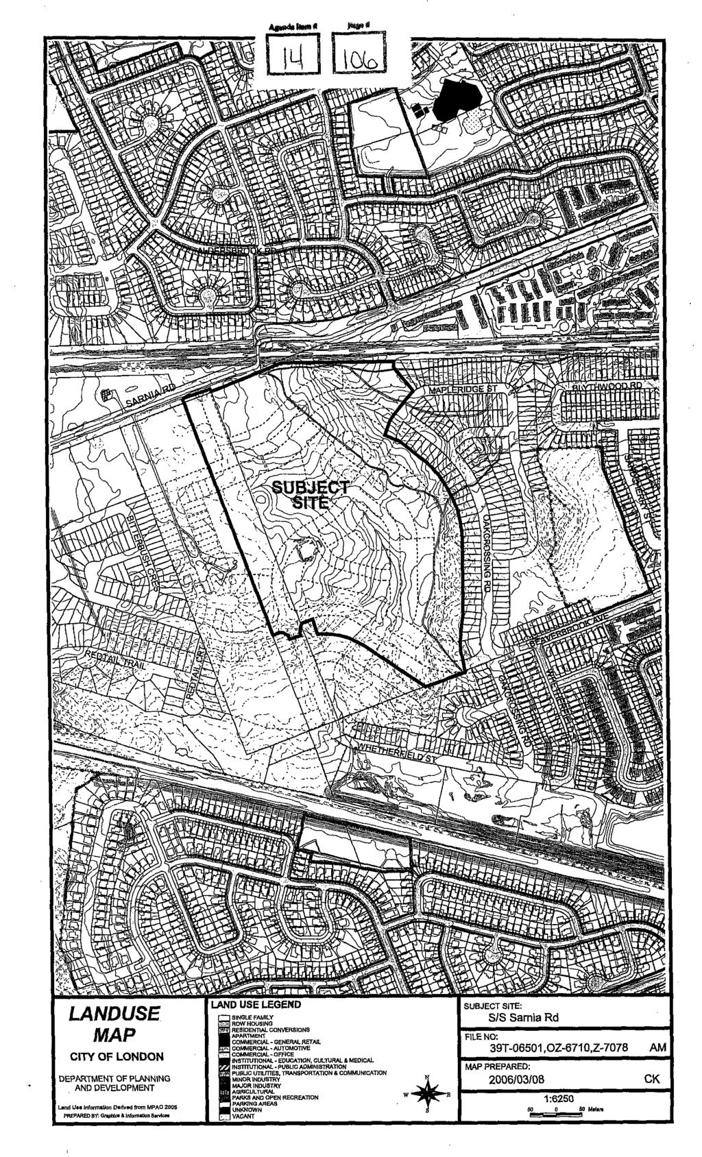
3 Agenda Item # Page # r-7-39t-06501/2-7078/ A..MacLean detached dwellings, townhouses and stacked townhouses and cluster housing at a maximum density of 25 units oer hectare and a maximum heiaht of 12 metres and neighbourhood facility uses such as churches, community centre; day care centres and schools BE REFUSED; PREVIOUS REPORTS PERTINENT TO THIS MATTER 39T Original Draft Approval report to Planning Committee - July T Original Draft Approval report to Planning Committee - July The recommended Draft Plan of Subdivision and Zoning By-law amendments are consistent with Official Plan land use designations. 2. The recommended draft plan of subdivision and associated Official PlanlZoning By-law amendments are consistent with the 2005 Provincial Policy Statement. 3. The proposed development provides for a variety of residential dwelling types and a school site to serve the existing and future residents of this community. 4. Conditions of draft approval will ensure that the subdivision is developed with full municipal services (sanitary, storm and water). BACKGROUND Date Application Accepted: January 6,2006 Agent: Jim Kennedy SITE CHARACTERISTICS: Current Land Use -Vacant Frontage - approximately 166 metres (545 feet) Depth - varies approx metres ( feet) Area hectares (55.6 acres) Shape - irregular 3
4
5
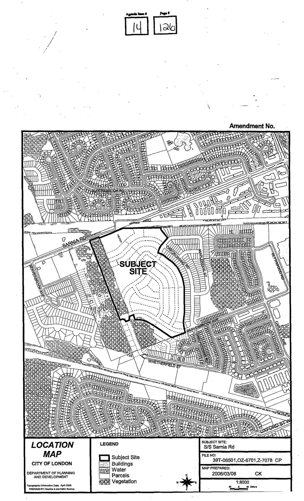
6 39T / SURROUNDING LAND USES: North - CPR tracks, single detached dwellings South -single detached dwellings, future low density residential East - vacant, future low density residential West - vacant. future low densitv residential OFFICIAL PLAN DESIGNATION: (refer to map) Low Density Residential, Multi-family Medium Density Residential EXISTING ZONING: (refer to map) Residential R2 Special Provision /Residential R4 Special Provision(R2-I (1 l)/r4-6(3)) Zone; and a Residential R4 Special ProvisionlResidentiaI R5 Special Provision (R4-6(3)/R5-7(2)) Zone; a Residential R1 Special ProvisionlNeighbourhood Facility (R1-4(11)/NF) and a Residential R1 Special Provision/ResidentiaI R2 Special ProvisionlNeighbourhood Facility (R1-4(11)/R2-1(6)/NF); and a Residential R1 Special ProvisionlNeighbourhood Facility (R1-4(11)/NF1) Zone (which applies to a portion of 796 PLANNING HISTORY The subject lands are part of two draft approved plans of subdivision - 39T owned by Drewlo Holdings and 39T owned by Oakcrossing Developments. The following map illustrates the location of the subject application as it relates to the two draft approved plans noted above. 4

7 LEGEND DOWNTOWN AREA REGIONAL SHOPPING AREA COMMUNITY SHOPPING AREA NEIGHBOURHOOD SHOPPING AREA ASSOCIATED SHOPPING AREA COMMERCIAL BUSINESS DISTRICT ARTERIAL MIXED USE DISTRICT HIGHWAY SERVICE COMMERCIAL RESTRlCTEDlHlGHWAY SERVICE COMMERCIAL a RESTRICTED SERVICE COMMERCIAL COMMERCIAL POLICY AREA MULTI - FAMILY, HIGH DENSINRESIDENTIAL MULTI - FAMILY MEDIUM DENSITY RESIDENTIAL a LOW DENSITY RESIDENTIAL OFFICE AREA OFFlCElRESlDENTlAL OFFICE BUSINESS PARK GENERAL INDUSTRIAL LIGHT INDUSTRIAL REGIONAL FACILITY COMMUNITY FACILITY OPEN SPACE n DEFERRED AREAS --I AREAS UNDER APPEAL L - II URBAN RESERVE - COMMUNITY G ROW URBAN RESERVE -INDUSTRIAL GROWTH RURAL SETTLEMENT ENVIRONMENTAL REVIEW AGRICULTURE URBAN GROWTH BOUNDARY THIS IS AN EXCERPT FROM THE PLANNINQ DIVISION'S WORKINQ CONSOLIDATION OF SCHEDULE A TO THE CITY OF LONDON OFFICIAL PLAN, WITH ADDED NOTATIONS CITY OF LONDON DEPARTMENT OF PLANNING AND DEVELOPMENT OFFICIAL PLAN SCHEDULE A - LAND USE... ^^._ *** 1-1 FILE NO. MAP PREPARED: March 07,2006 PREPARED By: Qraphlcs & lnformstlon SRNICOS I SCALE 1:30,000
8 SUBJECT LEGEND ~""! %d*w BEFkRhED AREAS ROAD CLASSIFICATION PROPOSED ROADICORRIDOR EXPRESSWAY +*** * PROPOBED EXPREBBWAY FREEWAYS PROPOSEDFREEWAYS ARTERIAL +A/ PROPOBED ARTERIAL PRIMARYCOLLECTOR *+e '*4*' PROPOSED PRJMARY COLLECTOR + +,+ +&.. J'd/ SECONDARY COLLECTOR 4. e... 0 * PROPOSED BECONDAWcbLLECTOR THIS IS AN EXCERPT FROM THE PLANNlNa DIVISION'S WORKlNa CONSOLIDATION OF SCHEDULE C TO THE CITY OF LONDON OFFICIAL PLAN, WITH ADDED NOTATIONS I I FILENO. I CITY OF LONDON DEPARTMENT OF PLANNING AND DEVELOPMENT 30~0660l,t~7078,0~-~:8t.lo AM OFFICIAL PLAN SCHEDULE C - TRANSPORTATION CORRIDORS March 08,2006

9 REGIONAL I COUNCIL APPROVED ZONING FOR THE SUBJECT SITE R4-6 3 IR5-7 2) R2-I 14 /R46(3 RZ-1(6)/R4-6, R14(1 I), R14(1 l)inf, RI 411)/R&6) &6~4(11~d-I(6)/N~l 1) LEGEND FOR ZONlNG BY-UWZ-I R1 -SINGLE DETACHED DWELLINGS R2 -SINGLE AND TWO UNIT DWELLINGS R3 -SINGLE TO FOUR UNIT DWELLINGS R4 - STREETTOWNHOUSE R5 -CLUSTER TOWNHOUSE RE - CLUSTER HOUSING ALL FORMS R7 -SENIOR'S HOUSING RE -MEDIUM DENSlTYfLOW RISE APTS R9 ~ MEDIUMTO HIGH DENSITYAPTS. R10 -HIGH DENSITYAPARTMENTS R11 - LODGING HOUSE - -..,.. -..,...._. na - no"tct" ARFA %A ~ SHOPPING AREA CSA COMMUNITY SHOPPING AREA NSA - NEIGHBOURHOOD SHOPPING AREA EDC -BUSINESS DISTRICT COMMERCIAL AC -ARTERIAL COMMERCIAL HS - HIGHWAY SERVICE COMMERCIAL RSC -RESTRICTED SERVICE COMMERCIAL CC -CONVENIENCE COMMERCIAL SS -AUTOMOBILE SERVICE STATION ASA -ASSOCIATED SHOPPING AREA COMMERCIAL FOR TOWNSHIP ZONES PLEASE SEE THE RELEVANT ZONING BY-LAW FOR A DESCRIPTION OF REGULATIONS OR - OFFICERESIDENTIAL OC OFFICE CONVERSION RO -RESTRICTED OFFICE OF -OFFICE RF -REGIONAL FACiLlTY CF - COMMUNITY FACILITY NF ~ NEIGHBOURHOOD FACILITY HER -HERITAGE DC -DAYCARE OS -OPEN SPACE CR ~ COMMERCIAL RECREATION OB -OFFICE BUSINESS PARK LI -LIGHT INDUSTRIAL GI -GENERAL INDUSTRIAL HI - HEAW INDUSTRIAL EX - RESOURCE EXTRACTIVE UR -URBAN RESERVE "h" -HOLDING SYMBOL 'D" - DENSITY SYMBOL "H" - HEIGHT SYMBOL "E' -BONUS SYMBOL "T" -TEMPORARY USE SYMBOL FILE NO CITY OF LONDON 39T-06501, & AM DEPARTMENT OF PLANNING AND DEVELOPMENT MAP PREPARED: - ZONING 2006/03/08 BY-LAW NO. 2.-I 1:6100 SCHEDULE A Meters THIS MAP IS AN UNOFFYCIACWRACT FROMTHEZONINGBY-IAW Wl'MMOEO NOTATIONS
10 Agenda Item # Page # r-lm 39T-06501/Z-7078/ Draft Approved Plan 39T Draft plan approval was granted by the Approval Authority on August 25, On September 8, 1999, A. Milliken Heisey of Kerzner, Papaz, MacDermid on behalf of CN Rail appealed the Decision of the City of London Approval Authority. The Board allowed the appeal of the draft plan of subdivision in part, and granted draft approval subject to conditions. The Ontario Municipal Board did not give the Approval Authority the power to grant final approval of this plan of subdivision (or any of its phases). Therefore, when each of the phases were brought forward for registration, the final approval report and plans were forwarded to the Ontario Municipal Board for final approval. Phase I of the plan of subdivision (33M 435) consisted of 65 single detached dwelling lots, 20 street townhouse blocks, 1 stormwater management block, 1 block to provide access to the stormwater management block, 1 safety/noise bermlbarrier block, 1 walkway block and several 0.3 m (1 ft) reserve blocks all served by the extension of Silversmith Street, Beaverbrook Avenue and by one new street. This plan was registered on November 28, Phase II (33M 460) consisted of 53 single detached dwelling lots, 1 multi-family block and several reserve blocks all served by an extension of Whetherfield Street, Beaverbrook Avenue and 2 new streets. Phase 111 consisted of 26 single detached dwelling lots, 2 multifamily blocks and several reserve blocks all served by an extension of Whetherfield Street and the creation of one new street, being Baird Street. The property owner is currently in process of having the 4Ih and final phase of this plan registered (which also included a potion of lands within draft approved plan 39T-99512). Draft Approved Plan 39T This plan was granted draft approval by the Approval Authority on August 26'h, The draft plan approval was appealed to the Ontario Municipal Board by Henry John and lngeborg Fennema. The Fennema's appealed the draft plan together with the concurrent Official Plan and Zoning By-law Amendments based on the proposal to classify the Beaverbrook Avenue extension as a primary collector road. Negotiations between parties resulted in the Beaverbrook Avenue being classified as a secondary collector road. This together with other minor modifications to the plan and revised conditions were presented to the Ontario Municipal Board on March 6, While the Board agreed with the modifications, it did not issue a DecisionlOrder on the draft plan until after a hearing on August 28, 2000 as this plan was dependant on the draft plan of subdivision to the south, owned by Oakridge Crossing development Limited, which was also the subject of an appeal. The Decision/Order, issued on September 15, 2000, dismissed the appeal by Mr. And Mrs. Fennema and granted approval to the modified draft plan of subdivision subject to modified conditions. The Board also granted authority for final approval for the plan of subdivision to the City of London Approval Authority. Phase one of this subdivision consisted of two commercial blocks served by a new secondary collector road (Blythwood Road) and was registered on February 1, Phase 2 consisted of 26 single detached dwellings served by Beaverbrook Avenue and was registered on May 3, Phase 3 consisted of 76 single detached dwelling lots served by Capulet Lane and Sandcherry Street; 1 multi-family residential block with frontage on Beaverbrook Avenue, Capulet Lane and Blythwood Road; 1 open space/park block; and 1 walkway block. Phase 3 was registered on August 26, Phase 4 consisted of 80 single detached dwelling lots and 1 multi-family block served by Blythwood Road. Phase 5 consisted of 167 single family lots, one (1) park block, one (1) walkway block served by Beaverbrook Avenue, Oakcrossing Road, Whetherfield Street, Maplewood Street and Maplewood Lane. This phase was registered in October
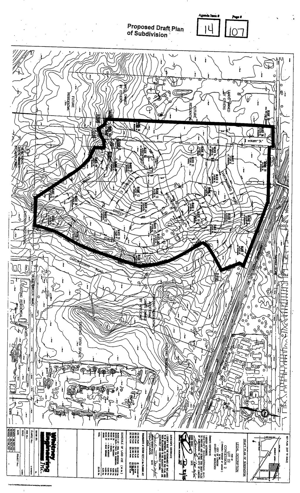
11 39T-06501/ Z-6710 Current Application The applicants have requested revisions to the draft approved plan which will assist in alleviating storm and sanitary sewer design issues in the remaining phases of the development. The redesign also utilizes a traffic roundabout instead of a bus bay to reduce cut through traffic and provide traffic calming measures. The use of the roundabout in the revised plan with an additional roundabout in the Deer Ridge Subdivision to the west will deter cut through traffic and provide a better street layout for traffic circulation within the Beaverbrook area. Based on the extent of the revisions (Le. substantial changes to the road pattern and the residential blocks) and the fact that these lands are co-owned it was determined that a new application for draft approval would be the most appropriate method to address the changes contemplated by both owners. I SIGNIFICANT DEPARTMENT/AGENCY COMMENTS I] Canadian Pacific Railway The proposed development is located adjacent to our Windsor Subdivision, which is classified as a principle main line. Canadian Pacific Railway is not in favour of residential developments adjacent to our right-of-way as this land use is not compatible with railway operations. The health, safety and welfare of future residents could be adversely affected by railway activities. However, to ensure the safety and comfort of adjacent residents and to mitigate as much as possible the inherent adverse environmental factors, we request that the following standard CPR requirements be considered should this application progress to Draft Plan Approval. PRINCIPAL MAIN LINE REQUIREMENTS 1. Berm, or combination berm and noise attenuation fence, having extensions or returns at the ends, to be erected on adjoining property, parallel to the railway right-of-way with construction according to the following: a) Minimum total height 5.5 metres above top-of-rail; b) Berm minimum height 2.5 metres and side slopes not steeper than 2.5 to 1. c) Fence, or wall, to be constructed without openings and of a durable material weighing not less than 20 kg. per square metre (4 Ib/sq.ft.) of surface area. No part of the bermhoise barrier is to be constructed on railway property A clause should be inserted in all offers of purchase and sale or lease, and be registered on title or included in the lease for each dwelling affected by any noise and vibration attenuation measures, advising that any berm, fencing, or vibration isolation features implemented are not to be tampered with or altered, and further that the owner shall have the sole responsibility for and shall maintain these features. Dwellings must be constructed such that the interior noise levels meet the criteria of the appropriate Ministry. A noise study should be carried out by a professional noise consultant to determine what impact, if any, railway noise would have on residents of proposed subdivisions and to recommend mitigation measures, if required. The Railway may consider other measures recommended by the study Setback of dwellings from the railway right-of-way to be a minimum of 30 metres. While no dwelling should be closer to the right-of-way than the specified setback, an unoccupied building, such as a garage, may be built closer. The 2.5 metre high earth berm adjacent to the right-of-way must be provided in all instances. Ground vibration transmission to be estimated through site tests. If in excess of the acceptable levels, all dwellings within 75 metres of the nearest track should be protected. The measures employed may be: a) Support the building on rubber pads between the foundation and the occupied 6
12 Agenda Item # Page # nr----l 39T structure so that the maximum vertical natural frequency of the structure on the pads is 12 Hz; b) c) Insulate the building from the vibration originating at the railway tracks by an intervening discontinuity or by installing adequate insulation outside the building, protected from the compaction that would reduce its effectiveness so that vibration in the building became unacceptable; or Other suitable measures that will retain their effectiveness over time A clause should be inserted in all offers of purchase and sale or lease and in the title deed or lease of each dwelling within 300m of the railway right-of-way, warning prospective purchasers or tenants of the existence of the Railway's operating right-of-way; the possibility of alterations including the possibility that the Railway may expand its operations, which expansion may affect the living environment of the residents notwithstanding the inclusion of noise and vibration attenuating measures in the design of the subdivision and individual units, and that the Railway will not be responsible for complaints or claims arising from the use of its facilities and/or operations. Any proposed alterations to the existing drainage pattern affecting railway property must receive prior concurrence from the Railway, and be substantiated by a drainage report to be reviewed by the Railway. A 1.83 metre high chain link security fence be constructed and maintained along the common property line of the Railway and the development by the developer at his expense, and the developer is made aware of the necessity of including a covenant running with the lands, in all deeds, obliging the purchasers of the land to maintain the fence in a satisfactory condition at their expense. Any proposed utilities under or over railway property to serve the development must be approved prior to their installation and be covered by the Railway's standard agreement. Staff response: Development Engineering London Limited has provided a noise assessment to address previous phases of this development. Staff contend that an addendum to the previous noise and vibration assessment will address the issues raised by CP. Also, the addendum will provide additional information on the required noise attenuation barrier height. As a result the conditions of draft approval will require a 2.5 metre high safety berm and staff will be relying on the noise study addendum to address fhe required height of the noise barrier. Also, the zoning recommended for those blocks which abut the CP rail ROW will include a special provision to address the required 30 metre setback to dwelling units. Canadian National Railway CN requires the owner to insert the following warning clause in all development agreements, offers to purchase, agreements of Purchase and Sale or Lease and include in a Noise Impact Statement: "Warning: Canadian National Railway Company or its assigns or successors in interest has or have a right-of-way within 300 metres from the land the subject hereof. There may be alterations to or expansions of the rail facilities on such right-of-way in the future including the possibility that the railway or its assigns or successors as aforesaid may expand its operations, which expansion may affect the living environment of the residents in the vicinity, notwithstanding the inclusion of any noise and vibration attenuating measures in the design of the development and individual dwelling(s). CN will not be responsible for any complaints or claims arising from use of such facilities andlor operations on, over or under the aforesaid right-of-way." They also recommend that the Owner engage a consultant to undertake an analysis of rail noise and provide abatement measures necessary to achieve the maximum level limits set by the Ministry of Environment.
13 Apda item #, Page # 39T-06501/2-7078/ Staff response: The conditions of draff approval will require that a warning clause be place on title to advise potential purchasers of the proximity. of the CN rail line. Given the distance between the closest point of the rail line and the CN rail right of way (approximately 265 metres), the existing noise attenuation fence and the proposed residential development between the rail line and the subject lands, staff contend that a noise study is not necessay Canada Post Corporation The owner is required to: a) include on all offers of purchase and sale, a statement that advises the prospective purchaser: i) that the hornelbusiness mail delivery will be from a designated Centralized Mail Box. ii) that the developers/owners be responsible for officially notifying the purchasers of the exact Centralized Mail Box locations prior to the closing of any home sales. b) the owner further agrees to: i) ii) iii) iv) work with Canada Post to determine and provide temporary suitable Centralized Mail Box locations which may be utilized by Canada Post until the curbs, boulevards and sidewalks are in place in the remainder of the subdivision. Install a concrete pad in accordance with the requirements of, and in locations to be approved by, Canada Post to facilitate the placement of Community Mailboxes Identify the pads above on the engineering servicing drawings. The pads are to be poured at the time the sidewalk and/or curb installation within each phase of the plan of subdivision, determine the location of all centralized mail receiving facilities in cooperation with Canada Post and to indicate the location of the centralized mail facilities on appropriate maps, information boards and plans. Maps are also to be prominently displayed in the sales office@) showing specific Centralized Mail Facility locations. L1 c) Canada Post's multi-unit policy, which requires that the ownerldeveloper provide the centralized mail facility at their own expense, will be in affect for buildings and complexes with a common lobby, common indoor or sheltered space. Upper Thames River Conservation Authority No objection to this proposal. Engineering and Environmental Services Department (EESD) Sanitary The Owner will be required to connect the proposed sanitary sewers to serve this plan to the existing 300 mm (12) sanitary sewer at Beaverbrook Avenue and Oakcrossing Road. Registration of this plan and subsequent development is subject to the availability of sewage treatment capacity at the Greenway Pollution Control Plant. As there is an intensification in density of portions of the subject lands through the proposed 8
14 Agenda Item # Page # r - l l 39T-06501/2-7078/ changes in zoning, the Owner's professional engineer shall undertake a sanitary capacity study of the downstream sewers to ensure there is enough capacity to support the changes in land use, all to the satisfaction of the City Engineer, and at no cost to the City. Stormwater Manaqement The subject lands are located within the Mud Creek Subwatershed and the storm outlet for these lands is the Mud Creek via the existing 1250 mm (54) storm sewer on Beaverbrook Avenue at Oakcrossing Road which outlets to the existing "Capulet Lane" regional Stormwater Management (SWM) Facility located within registered plan 33M-435. Water The Owner must connect the proposed watermains to serve this plan to the municipal water system, namely, to the existing municipal 400 mm (16) diameter water main on Sarnia Road. The Owner must provide "looping" of the water main system constructed for this subdivision to Sarnia Road and the subdivision to the west, all to the specifications of the City Engineer. Prior to applying for the 81st building permit, the Owner shall have it's professional engineer deliver confirmation that the watermain system has been looped. The Owner shall obtain all necessary approvals from the City Engineer for individual servicing of blocks in this subdivision, prior to the installation of any water services for the blocks. Transportation The owner must construct a raised median, including any necessary related pavement Widening on Sarnia Road to restrict turning movements at Street 'A' to rights in/out only to the satisfaction of the City Engineer. Street 'A from Sarnia Road to 45 metres (150) south is to have a minimum road pavement width (excluding gutters) of 12.0 metres (36.1') with a minimum road allowance of 22.5 metres (75'). The widened road on Street 'A is to be equally aligned from the centerline of the road and tapered back to the 9.5 metres (31.2) of road pavement width (excluding gutters) and 21.5 metres (70') of road allowance width for this street with 30 metre (100') long tapers on both street lines. If a parking plan is required for this subdivision, and increased pavement width is proposed to accommodate the parking plan, it is the Transportation Divisions preference that the road allowance width be increased a corresponding amount in order to maintain the standard 6.0 m wide boulevards on either side of the road. Further, the Owner shall make arrangements with the City for parking restrictions on one side of any street that requires an on-street parking plan as identified by the General Manager of Planning and Development, to the specifications and satisfaction of the City Engineer. The Owner shall register this requirement on the title of all affected lot in this plan upon registration of the plan in order to notify potential homeowners of this requirement. The Owner is required to dedicate sufficient land to widen Sarnia Road to 18.0 metres (59.06") from the centerline of the original road allowance. The Owner is reouired to dedicate 6.0 m x 6.0 rn "daylighting triangles" at the intersection of Street 'A' with Sarnia Road in accordance with the Z-1 Zoning By-law, Section The Owner is also required to dedicate 3.0 m x 3.0 m "daylighting triangles" at the intersection of 'collector' road streets in the plan at Street 'A and Oakcrossing Road and on the west side of Whetherfield Road at the south limit of Oakcrossing Road (ie. where 21.5 m r.0.w.k meet) to satisfy requirements necessary for servicing bus transit routes, as specified by the City Engineer. The Owner is required to construct a bicycle lane along the Sarnia Road frontage to the satisfaction of the City Engineer as part of any road work undertaken on Sarnia Road. The Owner is required to construct a roundabout at the intersection of Street 'C and Whetherfield Drive to the satisfaction of the City Engineer. The Owner shall ensure that 9
15 Agenda Item # Page # r-lr-- 39T-06501/2-7078/ driveways for lots that abut the roundabout are located in accordance with the EESD Design Specification and Requirements Manual. The Owner shall install street lighting at this intersection to the satisfaction of the City Engineer. PUBLIC LIAISON: On January 12, 2006, letters were sent to 94 surrounding area residents advising of the proposed raft plan of subdivision. Notice of the application was also published in "Living in the City" section of the London Free Press on January 21, 2006 Facility (RI-4(1 l)/r5-1/r6-3/nf) Zone to permit single detached dwellings, townhouses and stacked townhouses and cluster housing at a maximum density of 25 units per hectare and a maximum height of 12 metres and neighbourhood facility uses such as churches, community centres, day care centres and schools. A change to the zoning on Block 66 in drafi approved plan 39T (immediately west) FROM a Residential R1 Special Provision/Neighbourhood Facility (R1-4(11)/NF1) Zone TO a Residential R1 Special Provision/R5/R6/Neighbourhood Facility (R1-4(11)/R5-1/R6-3/NF) Zone is also under consideration in order to ensure that the final approved zoning on these two blocks (Block 6E - 39T and Block 31-39T-06501) is consistent. I Responses: None to date Official Plan Policies The Low Density Residential designation, which applies to the majority of these lands, permits low-rise, low density housing forms including detached, semi-detached and duplex dwellings(at a maximum density of 30 units per hectare) as the main permitted uses. The Multi-Family Medium Density designation, which applies to a small portion at the north west corner of this site, permits multiple-unit residential developments having a low rise profile, with a 10
16 39T-06501/2-7078/ maximum density of 75 units per hectare. Uses may include row houses, cluster houses, lowrise apartment buildings and certain specialized residential facilities such as small scale nursing homes. Uses permitted within the Low Density Residential designation may also be considered in areas designated for medium density residential development. Community facilities such as churches, community centres and schools are permitted in all residential land use designations. Proposal The following map illustrates the changes between the current application and the draft plan approval which was granted in Major changes include a realignment of the collector road at the northerly limit of the plan along with corresponding adjustments to the local streets, block reconfigurations and the extension of Beaverbrook Ave to the west. The applicant is proposing a block plan of subdivision with 27 low density residential blocks for single detached dwellings (with the potential for approximately 300 single detached lots) and one multi-family medium density residential blocks, ( max. 52 units based on density of 35 units per hectare). The applicant is also proposing a centrally located school block. This block may develop for low density residential uses if it is not required by the school board. The applicant's proposal to develop various forms of low and medium density residential uses and a school complies with the land use designations which apply to this parcel. Subdivision Design As noted above, the original draft approval for these lands (39T & 39T-99512) extended from the westerly limit of this draft plan (39T-06501) to Wonderland Road and from the CN rail line to Sarnia Rd/C.P. Rail line. The focal point of this original subdivision is the Beaverbrook Woods and a linear park adjacent to the woods. 11
 northerly through this draft plan.")
17 Agenda Item # Page # r--- 39T Location of Parkland and Stormwater Management Facility The streets have been layed out in this subdivision in a north-south pattern based on the existing topography. There is a central collector road which extends from the Oakcrossing Subdivision (south of Beaverbrook Avenue) northerly through this draft plan. The road continues through adjacent lands to the east (owned by Sifton properties) and reconnects with Beaverbrook Avenue The original draft plan also provided for associated shopping area commercial uses at the intersection of Wonderland Rd N. and Beaverbrook Ave. There is also a church located at the south west corner of Beaverbrook Rd and Wonderland Rd N. The current drafl plan is an extension of the residential subdivision to the east and it will allow for appropriate integration and transition of land uses. The local street pattern provides exposure to the central school site. One of the goals of the City's' goals is to discourage rear lotting and noise attenuation walls along arterial roads. The City also encourages street orientation of buildings in multi-family developments to eliminate continuous privacy fencing adjacent to the street. These items will be addressed through conditions of drafl approval. The proposal provides for a balance of low density and medium density forms of housing. As this is a block plan development, the issue of lot sizes will be reviewed prior to registration to ensure that there are a mix of sizes in keeping with the Small Lot Subdivision Design Guidelines. Issues dealing with the aesthetics of development on multi-family residential block will be examined in greater detail at the site plan approval stage. Parks and Open Space Required parkland has been dedicated in previous phases of the original draft approved plan (39T-99512). These parks are Block 78 in Plan 33M445 and Block 168 in Plan 33M
18 Agenda Item # Page # r-lm 39T-06501/2-7078/ Railway Concerns Both Canadian National Railway and the Canadian Pacific Railways have identified noise and vibration concerns with respect to the location of this development. As per our previous comments, given the distance between the closest point of the subdivision limit and the CN rail right of way (approximately 265 metres), the existing noise attenuation fence and the proposed residential development between the rail line and the subject lands, staff contend that a noise study is not necessary. The applicant has prepared a noise and vibration report to address the issue of noise as it relates to Canadian Pacific Rail operations to the north in response to the condition of the current draft approved plan 39T Due to the time that has passed an addendum to this report is appropriate to ensure that the noise and vibration issues are adequately addressed. In addition, appropriate noise warning clauses are required to be registered on title to these lands. This will be addressed through a condition of draft approval. The zoning proposed for the blocks abutting the CP rail line will include a special provision to address an appropriate setback from the ROW as per their request. Transportation Streets EESD-Transportation staff have advised that there is insufficient distance to construct a left turning lane along Sarnia Road given the proximity of the bridge which crosses the CPR tracks. As a result the owner will required to construct a raised median, including any necessary related pavement widening on Sarnia Road to restrict turning movements at Street 'A to rights in/out only to the satisfaction of the City Engineer. Consideration will be given to allow for full access to Street A once improvements to the bridge are carried out. The subdivision will be accessed through the extension of Beaverbrook Avenue, the extension of Oakcrossing Road, the extension of Whetherfield Avenue and a new collector road which connects Sarnia Road to Oakcrossing Road. There are also four local streets. This development is the final piece which connects draft approved plans 39T (owned by Sifton Properties) and the remainder of the Beaverbrook Subdivision to the east (owned, by Drewlo Holdings). All lots and blocks will be accessed from the internal road system. To ensure that Schedule C - Transportation Corridors of the Official Plan is consistent with the proposed draft plan of subdivision, it is recommended that Oakcrossing Gate (Street A), the extension of Beaverbrook Avenue (Street C) and Oakcrossing Road from Mapleridge Street to Oakcrossing Gate be identified as secondary collector roads. Roundabout One of the differences between the proposed plan and the plan which was draft approved in 2000 (39T-99512) is the extension of Beaverbrook Avenue which will complete the connection to Sarnia Road. The Owner will be required to construct a roundabout at the intersection of Street 'C' (Beaverbrook Road) and Whetherfield Drive to the satisfaction of the City Engineer. The Owner shall ensure that driveways for lots that abut the roundabout are appropriately located in accordance with the E.E.S.D. Design Specification and Requirements Manual. Servicing Sanitarv Services The Owner will be required to connect the proposed sanitary sewers to serve this plan to the existing 300 mm (12) sanitary sewer at Beaverbrook Avenue and Oakcrossing Road. This outlets to the 450 mrn (18) Oakridge trunk sanitary sewer system on Laurel Crescent to Kingsway Avenue and to the Mudd Creek sanitary sewer system. Registration of this plan and subsequent development is subject to the availability of sewage treatment capacity at the 13
19 39T-06501/2-7078/ Greenway Pollution Control Plant, Storm Water Manasement The subject lands are located within the Mud Creek Subwatershed and the storm outlet for these lands is the Mud Creek via the existing 1250 mm (54) storm sewer on Beaverbrook Avenue at Oakcrossing Road which outlets to the existing "Capulet Lane'! regional Stormwater Management (SWM) Facility located within registered plan 33M-435. Water Services The Owner will be required to connect the proposed watermains to serve this plan to the municipal water main on Sarnia Road. The Owner will be required to "loop" of the water main system for this subdivision to Sarnia Road and the subdivision to the west. Prior to applying for the 81st building permit, the Owner must have it's professional engineer deliver confirmation that the watermain system has been looped. Proposed Zoning The subject lands are currently zoned for various forms of low and medium density forms of housing and for neighhbourhood facility uses. The proposed zoning at the northerly limit of the plan reflects the changes to the street and block configuration as a result of the revised draft plan. The applicant and owner of the draft approved plan to the east have requested that the zoning of the school block be changed to allow for the flexibility of single low and medium density forms of housing should this block not develop for a school. Staff do not support requests to allow for different forms of housing (Le. freehold and cluster) as it creates uncertainty as to how this block will develop (ie street pattern has not been considered). Should the applicant wish in the future to develop this block for freehold residential lots it is appropriate to consider a rezoning application with an associated subdivision application to ensure that the street design, pedestrian connections, and lot configurations have undergone full public review, are appropriate and in keeping with the regulations of the requested zone. Based on this, staff do not recommend the requested R1-4(11) zone and are prepared to recommend a compound medium density (cluster) residential zone in combination with the existing neighbourhood facility zone. It is recommended that a holding provision (h- J be created and applied to the Block 29 to require the applicant to submit a noise and vibration study to ensure that development proposed for this block provides for appropriate noise and vibration mitigation measures. Based on our review of the draft plan of subdivision, Section 4.21 of the Z-1 Zoning By-law must also be amended to identify Oakcrossing Gate. (Street A) from Sarnia Road to Oakcrossing 'Road; the extension of Beaverbrook Avenue (Street C); and Oakcrossing Road from Beaverbrook Avenue to Oakcrossing Gate as secondar collector roads. It should also be noted that the zone lines of existing zones in this subdivision have been adjusted slightly to reflect the new street pattern. The recommended residential zones are appropriate and in conformity with the land use designations and Official Plan policies. Redline Revisions The following redline revisions are required for this draft plan: Show a traffic circle at the intersection of Whetherfield St and Beaverbrook Ave identify 3 x 3 m daylighting triangles at Street 'A' and Oakcrossing Road and on the west 14
20 mm Agenda Item # Page # side of Whetherfield Road at the south limit of Oakcrossing Road identify 6m x 6m daylight triangles at Oakcrossing Gate and Sarnia Rd 39T-06501/2-7078/ add 0.3 m reserves along the frontage of Sarnia Road, Block 32 (as shown on the plan), west limit of Street 'C' and west limit of Oakcrossing Road. Relocate walkway Block 30 to the west opposite Street A Add a walkway between Blocks 518 and Bocks 6i7 to connect the proposed crescent street to Oakcrossing Road This subdivision with the recommended zoning will provide a variety of residential dwelling types and a centrally located school site to benefit existing and future residents. The proposed drafl plan of subdivision and associated Zoning By-law amendments are appropriate and consistent with the Official Plan and the 2005 Provincial Policy Statement. IVlSlON AND March 8, 2006 AMlam "Attach." Y\Shared\SUB&SPEC\SUBOlWOO6\39T-O65Ol Drewlo - Norhwest\39T PCreporl dot 15
21 Agenda Item # Page # RED-LINE REVISIONS
22 39T-06501/2-7078/ Appendix "A" Bill NO. (number to be inserted by Clerk's office) insert year By-law No. C.P.-<284(inserled by Clerk's Offce) A by-law to amend the Official Plan for the City of London, 1989 relating to lands at the north west corner of Beaverbrook Avenue and Oakcrossing Road. follows: The Municipal Council of The Corporation of the City of London enacts as 1. Amendment NO. (to be inserted by Clerk's Office) to the Official Plan for the City Of London Planning Area , as contained in the text attached hereto and forming part of this by-law, is adopted. 2. This by-law shall come into effect in accordance with subsection 17(38) of the Planning Act, R.S , c.p. 13. PASSED in Open Council on March 27, 2006 Anne Marie DeCicco Mayor Kevin Bain City Clerk First Reading - March 27, 2006 Second Reading - March 27,2006 Third Reading - March 27,
23 Agenda Item # Page # r-lr AMENDMENT NO. to the OFFICIAL PLAN FOR THE CITY OF LONDON 39T-06501/2-7078/ A. Maclean A. PURPOSE OF THIS AMENDMENT The purpose of this Amendment is: 1. To extend one secondary collector road, realign one secondary collector road and add one new secondary collector road connection on Schedule "C", Transportation Corridors, in the Official Plan for the City of London. B. LOCATION OF THIS AMENDMENT 1. This Amendment applies to lands located the northwest corner of Beaverbrook Avenue and Oakcrossing Road, in the City of London. C. BASIS OF THE AMENDMENT The subdivision will be accessed through the realignment of Beaverbrook Avenue, the extension of Oakcrossing Road, the extension of Whetherfield Avenue and a new collector road which connects Sarnia Road to Oakcrossing Road. This draft plan is an extension of the residential subdivision to the east and the new collector roads will allow for appropriate integration with existing subdivisions in this area. D. THE AMENDMENT The Official Plan for the City of London is hereby amended as follows: 1. Schedule "C", to the Official Plan for the City of London is amended by extending one secondary collector road, realigning one secondary collector road and adding one new secondary collector road as shown on the attached schedule. 17
24
25 ~ AMENDMENT No. Add: Secondary Collectors LEGEND ROAD CLASSIFICATION PROPOSED ROAD CORRIDOR :... DEFERRED AREAS %...I EXPRESSWAY I * PROPOSED EXPRESSWAY FREEWAYS PROPOSED FREEWAYS ARTERIAL w ** PROPOSED ARTERIAL /\I + PRIMARY COLLECmR / *+./ PROPOSED PRIMARY COLLECTOR fl../' SECONDARY COUECTOR..,. 7.*. *' PROPOSEDSECONDARYCOUCTDR THIS ISAN EXCERPTFROMTHEPLANNINO OIVl~IO"SWaR13NOCONIlOUDATlON Of SCHEDULE C TO THECITYOFUJNDON OFFICIALPLAN. WlTHADDEDNDTATlONLl SCHEDULE 1 TO OFFICIAL PLAN AMENDMENT NO. I 39T-06501,OZ-6710,Z-7078 AM MAP PREPARED March 08,2006
26 Agenda Item it Page # r - l m 39T-06501/2-7078/0Z-6710 APPENDIX "B" Bill NO. (number to be inserted by Clerk's Office) insert year By-law No. Z A by-law to amend By-law No. Z.-1 to rezone an area of land located north west corner of Beaverbrook Avenue and Oakcrossing Road. WHEREAS Drewlo Holdings Inc. & Oakridge Crossing Development Limited have applied to rezone an area of land located north west corner of Beaverbrook Avenue and Oakcrossing Road, as shown on the map attached to this by-law, as set out below; AND WHEREAS this rezoning conforms to the Official Plan; THEREFORE the Municipal Council of The Corporation of the City of London enacts as follows: Schedule "A" to By-law No is amended by changing the zoning applicable to lands located at the north west corner of Beaverbrook Avenue and Oakcrossing Road, as shown on the attached map comprising part of Key Map No. 47, FROM a Residential R2 Special Provision /Residential R4 Special Provision(R2-I (14)/R4-6(3)) Zone; a Residential R4 Special ProvisionlResidentiaI R5 Special Provision (R4-6(3)/R5-7(2)) Zone; a Residential R1 Special ProvisionlNeighbourhood Facility (R1-4(1 I)/NF); a Residential R1 Special ProvisionlNeighbourhood Facility (R1-4(11)/NF1) Zone and a Residential R1 Special ProvisionlResidential R2 Special ProvisionlNeighbourhood Facility (R1-4(11)/R2-1(6)/NF) TO a Holding Residential R4 Special ProvisionlResidentiaI R5 Special Provision/ResidentiaI R6 Special Provision (h--r4-6(3)/r5-6 ( )/R6-5 ( )) Zone ; and a Residential R5/RG/Neighbourhood Facility (R5-1/R6-3/NF) Zone. 1) Section Number 9 of the R5 Zone to By-law No is amended by adding the following Special Provision: Section No. 9.4 Zone (R5-6 Zone Variation) a) Regulations: i) Dwelling Setback Right of Way (Minimum): 120 metres (394 feet) in the absence of a combination safety berm and acoustic fence adjoining and parallel to the rail right of way, or 30 metres (98 feet) in conjunction with the safety/acoustic berm noted above. 2) Section Number 'IO of the R6 Zone to By-law No is amended by adding the following Special Provision: Section No Zone (R6-5 Zone Variation) a) Regulations: 18
27 Agenda Item # Page# r-----im 39T-06501/2-7078/0Z-6710 i) Dwelling Setback Right of Way (Minimum): 120 metres (394 feet) in the absence of a combination safety berm and acoustic fence adjoining and parallel to the rail right of way, or 30 metres (98 feet) in conjunction with the safety/acoustic berm noted above. 3) Section 3.8(2) of the Holding Zone Provisions Section to By-law Z-1 is amended by adding the following holding provision: h-- Purpose: To ensure there are no land use conflicts between the adjacent arterial roads and/or rail line and the proposed residential uses, the h- -shall not be deleted until the owner agrees to implement all noise and vibration attenuation measures, recommended in noise and vibration assessment reports acceptable to the City of London. 4) Section 4.21 of the General Provision - Specific Roads Section of By-law No. Z.-1 is amended by adding the following streets hereto: Street Limit of Rd Street From To Classification Allowance Beaverbrook Oakcrossing Rd Westerly limit Secondary Collector m Avenue of plan 39T (35.3 ft) Oakcrossing Sarnia Rd Oakcrossing Rd Secondary Collector Gate (35.3 ft) Oakcrossing Beaverbrook Oakcrossing Gate Secondary Collector 1 Q.75 Road Avenue (35.3 ft) The inclusion in this By-law of imperial measure along with metric measure is for the purpose of convenience only and the metric measure governs in case of any discrepancy between the two measures. This By-law shall come into force and be deemed to come into force in accordance with subsection 34(21) of the Planning Act, R.S.O. 1990, c. P.13, either upon the date of the passage of this by-law or as otherwise provided by the said subsection. PASSED in Open Council on March 27,2006. Anne Marie DeCicco Mayor First Reading - March 27, 2006 Second Reading - March 27,2006 Third Reading - March 27, 2006 Kevin Bain City Clerk 19

28 Agenda Item # Page # File Number: , , 39T Planner: AM Date Prepared: 2006/03/08 Technician: CK By-Law No: 2.4. SUBJECT SITE SCALE 1: Meters I 5:

29 0 metres NOTIFICATION MAP Radius Buffer Subject Site: 778 Sarnia Rd Applicant: Drewlo Holdings Inc. Roll Number: Planner: Allister MacLean Created By: Allister Maclean File Number: 39T Date: 3/7/2006 CORPORATION OF THE CITY OF LONDON Prepared By: PD -Planning Scale: 1 : 6000 USubject Site Water R Draft Approved Parcels - w Rail Park loo01 LEGEND Buildings Addresses
Agenda Item # Page # CHAIR AND MEMBERS - PLANNING COMMllTEE
 , Agenda Item # Page # II TO: FROM: SUBJECT: CHAIR AND MEMBERS - PLANNING COMMllTEE R. W. PANZER ACTING GENERAL MANAGER OF PLANNING AND DEVELOPMENT APPLICATION BY: TIM HORTONS 68 SOUTHDALE ROAD WEST PUBLIC
18TH REPORT OF THE. FROM a Holding Residential R1 (h-h-57-r1-8) Zone. FROM a Holding Residential R6 (h.h-57.h-71.r6-4) Zone
 Zone. FROM a Holding Residential R6 (h.h-57.h-71.r6-4) Zone") 18TH REPORT OF THE Special meeting held on June 25, 2007, commencing at 4:OO p.m. PRESENT Councillor J. L. Baechler (Chair), Controllers G. Barber and G. Hume and Councillors N. Branscombe, J. P. Bryant
18TH REPORT OF THE Special meeting held on June 25, 2007, commencing at 4:OO p.m. PRESENT Councillor J. L. Baechler (Chair), Controllers G. Barber and G. Hume and Councillors N. Branscombe, J. P. Bryant
]y]q EFFECT ON URBAN WORKS RESERVE FUND AND DEVELOPMENT CHARGES RESERVE FUNDS' $ 1,043,638
![]y]q EFFECT ON URBAN WORKS RESERVE FUND AND DEVELOPMENT CHARGES RESERVE FUNDS' $ 1,043,638](/thumbs/87/96511569.jpg "]y]q EFFECT ON URBAN WORKS RESERVE FUND AND DEVELOPMENT CHARGES RESERVE FUNDS' $ 1,043,638") ]y]q 4 Page # 1 File Number: 39T-99522 That, on the recommendation of the Acting General Manager of Planning and Development, on the advice of the General Manager of Environmental & Engineering Services
]y]q 4 Page # 1 File Number: 39T-99522 That, on the recommendation of the Acting General Manager of Planning and Development, on the advice of the General Manager of Environmental & Engineering Services
kl bl Agenda Item # Page #
 kl bl Agenda Item # Page # TO: FROM: SUBJECT CHAIR AND MEMBERS -PLANNING COMMITTEE R. W. PANZER GENERAL MANAGER OF PLANNING AND DEVELOPMENT APPLICATION BY MARC0 AND SlLVlA TRAVAGLlNl 1060 OXFORD STREET
Agenda Item # Page # CHAIR AND MEMBERS - PLANNING COMMITTEE R. W. PANZER GENERAL MANAGER OF PLANNING AND DEVELOPMENT
 ~~~~~ ~ ~~ Agenda Item # Page # TO: FROM: SUBJECT: CHAIR AND MEMBERS - PLANNING COMMITTEE R. W. PANZER GENERAL MANAGER OF PLANNING AND DEVELOPMENT APPLICATION BY696743 ONTARIO INC. (M. DZIADURA) A PORTION
TOTTENHAM SECONDARY PLAN
 TOTTENHAM SECONDARY PLAN AMENDMENT NO. 11 TO THE OFFICIAL PLAN OF THE TOWN OF NEW TECUMSETH The following text and schedules to the Official Plan of the Town of New Tecumseth constitute Amendment No. 11
3.1. OBJECTIVES FOR RESIDENTIAL LAND USE DESIGNATIONS GENERAL OBJECTIVES FOR ALL RESIDENTIAL DESIGNATIONS
 3. RESIDENTIAL LAND USE DESIGNATIONS INTRODUCTION The Residential land use designations provide for housing and other land uses that are integral to, and supportive of, a residential environment. Housing
SECTION 10 RESIDENTIAL R6 ZONE
 SECTION 10 RESIDENTIAL R6 ZONE 10.1 GENERAL PURPOSE OF THE R6 ZONE These Zone variations provide for and regulate medium density development in various forms of cluster housing from single detached dwellings
5. That the Owner shall agree that all development Blocks shown within the Draft Plan will be connected to full municipal services.
 Conditions Relating to Draft Plan of Subdivision Approval East Fonthill 26T 01014 (Draft Plan dated December 1, 2013, and revised August 28, 2014), the Town of Pelham 1. This approval applies to the Draft
SECTION 9 RESIDENTIAL R5 ZONE
 SECTION 9 RESIDENTIAL R5 ZONE 9.1 GENERAL PURPOSE OF THE R5 ZONE This R5 Zone provides for and regulates medium density residential development in the form of cluster townhouses. Different intensities
Chair and Members Planning and Economic Development Committee
 TO: FROM: Chair and Members Planning and Economic Development Committee Melissa Halford Manager of Planning DATE: June 23, 2016 SUBJECT: Amendment No. 6 to Draft Approval Subdivision File No. S2006-3 (Loon
PLANNING REPORT Gordon Street City of Guelph. Prepared on behalf of Ontario Inc. March 17, Project No. 1507
 PLANNING REPORT 1131 Gordon Street City of Guelph Prepared on behalf of 1876698 Ontario Inc. March 17, 2016 Project No. 1507 423 Woolwich Street, Suite 201, Guelph, Ontario, N1H 3X3 Phone (519) 836-7526
CHAIR AND MEMBERS PLANNING & ENVIRONMENT COMMITTEE JOHN M. FLEMING MANAGING DIRECTOR, PLANNING AND CITY PLANNER
 TO: FROM: SUBJECT: CHAIR AND MEMBERS PLANNING & ENVIRONMENT COMMITTEE JOHN M. FLEMING MANAGING DIRECTOR, PLANNING AND CITY PLANNER APPLICATION BY: KIM NGUYEN 1448 ADELAIDE STREET NORTH PUBLIC PARTICIPATION
TO: CHAIR AND MEMBERS PLANNING AND ENVIRONMENT COMMITTEE
 TO: CHAIR AND MEMBERS PLANNING AND ENVIRONMENT COMMITTEE FROM: GEORGE KOTSIFAS, P.ENG. MANAGING DIRECTOR, DEVELOPMENT & COMPLIANCE SERVICES AND CHIEF BUILDING OFFICIAL SUBJECT: APPLICATION BY: SIFTON PROPERTIES
For Vintages of Four Mile Creek Town of Niagara on the Lake, Ontario
 Planning Impact Analysis For Vintages of Four Mile Creek Town of Niagara on the Lake, Ontario Prepared by: Upper Canada Consultants 261 Martindale Road Unit #1 St. Catharines, Ontario L2W 1A1 Prepared
1Agenda Item d Page #
 1Agenda Item d Page # CHAIR AND MEMBERS - PLANNING COMMllTEE FROM: R. W. PANZER GENERAL MANAGER OF PLANNING AND DEVELOPMENT APPLICATION BY: CITY OF LONDON () 1551942 ONTARIO LTD. (0216737) 225-317 & 244-320
3035 Weston Road - Official Plan and Zoning By-law Amendment and Draft Plan of Subdivision Applications - Request for Directions Report
 STAFF REPORT ACTION REQUIRED 3035 Weston Road - Official Plan and Zoning By-law Amendment and Draft Plan of Subdivision Applications - Request for Directions Report Date: December 18, 2007 To: From: Wards:
Paul D. Ralph, BES, RPP, MCIP, Commissioner, Development Services Department
 Public Report To: From: Report Number: Development Services Committee Paul D. Ralph, BES, RPP, MCIP, Commissioner, Development Services Department DS-16-50 Date of Report: April 14, 2016 Date of Meeting:
and Members of Municipal Council
 REPORT TO: SUBMITTED BY: SUBJECT: Mayor James M. Diodati and Members of Municipal Council Planning, Building & Development 26T-11-2017-002 Winzen Niagara Draft Plan of Subdivision 4825 Pettit Avenue Applicant:
OFFICE CONSOLIDATION
 OFFICE CONSOLIDATION SECONDARY PLAN AREA 2A THE NORTHWEST SANDALWOOD PARKWAY SECONDARY PLAN February 2010 EXPLANATORY NOTES (Secondary Plan Area 2(a)) General (pertaining to all secondary plan office consolidations)
8.5.1 R1, Single Detached Residential District
 8.5.1 R1, Single Detached Residential District The purpose of this district is to provide for residential development in the form of single detached dwellings. Dwelling, Single Detached Home Business,
Frequently Asked Questions
 Frequently Asked Questions Cambridge West Land Use Planning Matters January 10, 2018 Q1 What is proposed for the undeveloped lands within the Cambridge West area? A. Four separate landowners each own part
Staff Report for Council Public Meeting
 Agenda Item 3.3 Staff Report for Council Public Meeting Date of Meeting: September 27, 2017 Report Number: SRPRS.17.134 Department: Division: Subject: Planning and Regulatory Services Development Planning
MIDHURST DRAFT PLAN OF SUBDIVISION CONDITIONS OF APPROVAL SP-T-1005: D. Hickling August 29, 2014August 2, 2017
 No. Conditions DRAFT PLAN 1. This approval applies to the proposed draft plan of subdivision located at PT E1/2 LT 15 CON 6 Vespra, PT E1/2 LT 14 CON 6 Vespra, as in RO1472251; S/T RO147294; S/T easement
Guidelines for the Approval of New Homes Sales Offices (Building Permits, Agreements, Securities)
") Guidelines for the Approval of New Homes Sales Offices (Building Permits, Agreements, Securities) ENCLOSURES: Site Plan Application Building Permit Application Grading and Drainage Approval Requirements
Guidelines for the Approval of New Homes Sales Offices (Building Permits, Agreements, Securities) ENCLOSURES: Site Plan Application Building Permit Application Grading and Drainage Approval Requirements
Planning Justification Report
 Planning Justification Report 101 Kozlov Street, Barrie, Ont. Destaron Property Management Ltd. November 2015 Revised February 2017 TABLE OF CONTENTS Page 1.0 INTRODUCTION... 1 2.0 DESCRIPTION OF SUBJECT
APPENDIX "39T "
 14 APPENDIX "39T-00513-1" (Conditions to be included for Draft Plan Approval) THE CORPORATION OF THE CITY OF LONDON'S CONDITIONS AND AMENDMENTS TO FINAL APPROVAL FOR THE REGISTRATION OF THE SUBDIVISION,
PLANNING REPORT. 33 Arkell Road City of Guelph. Prepared on behalf of OHM Arkell Inc. August 4, Project No. 1327
 PLANNING REPORT 33 Arkell Road City of Guelph Prepared on behalf of OHM Arkell Inc. August 4, 2015 Project No. 1327 423 Woolwich Street, Suite 201, Guelph, Ontario, N1H 3X3 Phone (519) 836-7526 Fax (519)
CITY OF VAUGHAN EXTRACT FROM COUNCIL MEETING MINUTES OF MAY 16, 2017
 CITY OF VAUGHAN EXTRACT FROM COUNCIL MEETING MINUTES OF MAY 16, 2017 Item 1, Report No. 18, of the Committee of the Whole (Public Hearing), which was adopted without amendment by the Council of the City
fgenda Item;, ~ ~- CHAIR AND MEMBERS - PLANNING COMMITTEE
 ~ ~- fgenda Item;,, Page # 39T-05501E-6853 J. LEUNISSEN I! To:. SUBJECT: CHAIR AND MEMBERS - PLANNING COMMITTEE 11 FROM: 1 R. W. PANZER II GENERAL MANAGER OF PLANNING AND DEVELOPMENT APPLICATION BY AUBURN
TOWN OF WHITBY REPORT RECOMMENDATION REPORT
 TOWN OF WHITBY REPORT RECOMMENDATION REPORT REPORT TO: Planning and Development Committee REPORT NO: PL 4-08 DATE OF MEETING: January 21, 2008 FILE NO(S): MI-01-07 (SW- 2002-03) PREPARED BY: Planning Department
SUBJECT: Official Plan and Zoning By-law Amendment Applications for 4853 Thomas Alton Boulevard
 Page 1 of Report PB-100-16 SUBJECT: Official Plan and Zoning By-law Amendment Applications for 4853 Thomas Alton Boulevard TO: FROM: Development and Infrastructure Committee Planning and Building Department
11 FROM: I R. W. PANZER II
 ~!I ~ Agenda Item # Page # nn b 1 Alanna Rllev 11 FROM: I R. W. PANZER II I1 SUBJECT: GENERAL MANAGER OF PLANNING AND DEVELOPMENT APPLICATION BY:-JOAN DOVER 1452 BYRON BASELINE ROAD PUBLIC PARTICIPATION
Staines Road and Steeles Avenue Zoning and Subdivision Applications Final Report
 STAFF REPORT ACTION REQUIRED Staines Road and Steeles Avenue Zoning and Subdivision Applications Final Report Date: November 13, 2007 To: From: Wards: Reference Number: Scarborough Community Council Director,
MINTO COMMUNITIES INC. AVALON WEST STAGE 4 PLANNING RATIONALE. July Prepared for:
 MINTO COMMUNITIES INC. AVALON WEST STAGE 4 PLANNING RATIONALE July 2015 Prepared for: MINTO COMMUNITIES INC. 200 180 Kent Street Ottawa, Ontario K1P 0B6 Prepared by: J.L. RICHARDS & ASSOCIATES LIMITED
CITY CLERK. Phase 4 Scarborough Transportation Corridor Land Use Study - SC-W (Ward 36 - Scarborough Southwest)
") CITY CLERK Clause embodied in Report No. 4 of the, which was before the Council of the City of Toronto at its meeting held on May 21, 22 and 23, 2002. 14 Phase 4 Scarborough Transportation Corridor Land
CITY CLERK Clause embodied in Report No. 4 of the, which was before the Council of the City of Toronto at its meeting held on May 21, 22 and 23, 2002. 14 Phase 4 Scarborough Transportation Corridor Land
EVALUATION REPORT PLANNING DEPARTMENT
 EVALUATION REPORT PLANNING DEPARTMENT To: Chair and Members of the Committee of Adjustment and Council, Municipality of North Middlesex From: Stephanie Poirier, Planner, County of Middlesex Date: Re: Application
Infrastructure, Development and Enterprise Services
 Staff Report To Service Area City Council Infrastructure, Development and Enterprise Services Date Monday, April 9, 2018 Subject Report Number Statutory Public Meeting 671 Victoria Road North Proposed
City of Grande Prairie Development Services Department
 City of Grande Prairie Development Services Department COUNTRYSIDE SOUTH OUTLINE PLAN Prepared by: GPEC Consulting Ltd. #202, 10712-100th Street Grande Prairie, AB Council Resolution of August 20, 2001
Members of the City of Brantford Committee of Adjustment. 1.0 TYPE OF REPORT Committee of Adjustment Decision Regarding an Application for Consent
 DATE: October 18 th 2017 REPORT NO. CD2017-168 TO: Members of the City of Brantford Committee of Adjustment FROM: Brandon Kashin, Current Development Planner 1.0 TYPE OF REPORT Committee of Adjustment
AGENDA 1. CALL TO ORDER :00 P.M.
 MUNICIPAL PLANNING COMMISSION REGULAR MEETING CITY HALL COUNCIL CHAMBERS SEPTEMBER 24, 2015 AGENDA 1. CALL TO ORDER ------------------------------------------------------------------------ 7:00 P.M. 2.
CITY OF VAUGHAN EXTRACT FROM COUNCIL MEETING MINUTES OF DECEMBER 11, 2012
 Item 6, Report No. 50, of the Committee of the Whole (Public Hearing), which was adopted, as amended, by the Council of the City of Vaughan December 11, 2012, as follows: By receiving Communication C1
APPLICATIONS FOR OFFICIAL PLAN AMENDMENT AND ZONE CHANGE
 COMMUNITY AND STRATEGIC PLANNING P. O. Box 1614, Court House, Woodstock Ontario N4S 7Y3 Phone: 519-539-9800 Fax: 519-537-5513 Web Site: www.county.oxford.on.ca Our Files: OP 11-153 & ZON 3-07-18 APPLICATIONS
Committee of Adjustment Agenda
 Committee of Adjustment Agenda Hearing Date: May 25, 2017 Time: 7:00 p.m. Location: 225 East Beaver Creek Road, 1 st Floor (Council Chambers) Call to Order Disclosure of Pecuniary Interest Requests for
ARTICLE 23 CONDOMINIUM STANDARDS
 ARTICLE 23 CONDOMINIUM STANDARDS Section 23.01 Intent. The intent of this Article is to provide regulatory standards for condominiums and site condominiums similar to those required for projects developed
MIDHURST DRAFT PLAN OF SUBDIVISION CONDITIONS OF APPROVAL SP-T-1004: Micks August 29, 2014August 2, 2017
 No. Conditions DRAFT PLAN 1. This approval applies to the proposed draft plan of subdivision located at PT W1/2 LT 14 CON 6 Vespra as in RO1442683 except PT 3 51R38091 subject to an easement as in RO144798;
COUNTY OF BRANT DEVELOPMENT SERVICES DEPARTMENT COMMITTEE OF ADJUSTMENT. Chair and Members of the Committee of Adjustment
 COUNTY OF BRANT DEVELOPMENT SERVICES DEPARTMENT COMMITTEE OF ADJUSTMENT TO: FROM: Chair and Members of the Committee of Adjustment Ruchika Angrish, Senior Planner DATE: January 23, 2014 REPORT: CA-14-06
DEVELOPMENT APPLICATION PRE-CONSULTATION FORM
 DEVELOPMENT APPLICATION PRE-CONSULTATION FORM Meeting Date: Property Owner: Site Address: Applicant & Address Site Area: APPLICATION TYPE (check applicable applications): Local Official Plan Amendment
2 Holiday Drive - Zoning By-law Amendment Application - Final Report
 STAFF REPORT ACTION REQUIRED 2 Holiday Drive - Zoning By-law Amendment Application - Final Report Date: March 20, 2013 To: From: Wards: Reference Number: Etobicoke York Community Council Director, Community
SECTION 15 - R3 - RESIDENTIAL THIRD DENSITY ZONE
 SECTION 15 - R3 - RESIDENTIAL THIRD DENSITY ZONE Within the Residential Third Density (R3) Zone, no person shall use any land, erect, alter, enlarge, use or maintain any building or structure for any use
STAFF REPORT. December 18, Etobicoke Community Council. Director, Community Planning, West District
 STAFF REPORT December 18, 2002 To: From: Subject: Etobicoke Community Council Director, Community Planning, West District Final Report Application to Amend the Etobicoke Zoning Code 1137-1141 Royal York
THE CORPORATION OF THE TOWN OF GRAVENHURST BY-LAW 2017-
 THE CORPORATION OF THE TOWN OF GRAVENHURST BY-LAW 2017- A By-law to adopt a Ontario Municipal Board Order for Zoning By-law Application (ZA 48-2010) (OMB Case No. PL110213) WHEREAS a Zoning Amendment Application
Draft Model Access Management Overlay Ordinance
 Draft Model Access Management Overlay Ordinance This model was developed using the City of Hutchinson and the Trunk Highway 7 corridor. The basic provisions of this model may be adopted by any jurisdiction
Residential (170 detached lots) Park, Buffer, Walkways
 Park, Buffer, Walkways") COMMITTEE OF THE WHOLE SEPTEMBER 3, 2002 ZONING BY-LAW AMENDMENT FILE Z.01.024 DRAFT PLAN OF SUBDIVISION FILE 19T-01V04 HUMBERPLEX DEVELOPMENTS INC. REPORT #P.2001.35 Recommendation The Commissioner of
COMMITTEE OF THE WHOLE SEPTEMBER 3, 2002 ZONING BY-LAW AMENDMENT FILE Z.01.024 DRAFT PLAN OF SUBDIVISION FILE 19T-01V04 HUMBERPLEX DEVELOPMENTS INC. REPORT #P.2001.35 Recommendation The Commissioner of
Cover Letter with Narrative Statement
 Cover Letter with Narrative Statement March 31, 2017 rev July 27, 2017 RE: Rushton Pointe Residential Planned Unit Development Application for Public Hearing for RPUD Rezone PL2015 000 0306 Mr. Eric Johnson,
CHAIR AND MEMBERS PLANNING AND ENVIRONMENT COMMITTEE
 TO: FROM: SUBJECT: CHAIR AND MEMBERS PLANNING AND ENVIRONMENT COMMITTEE GEORGE KOTSIFAS, P. ENG. MANAGING DIRECTOR, DEVELOPMENT & COMPLIANCE SERVICES AND CHIEF BUILDING OFFICIAL APPLICATION BY: 748094
Committee of Adjustment Agenda
 Committee of Adjustment Agenda Hearing Date: July 6, 2017 Time: 7:00 p.m. Location: 225 East Beaver Creek Road, 1 st Floor (Council Chambers) Staff reports obtained online do not include hard copy information
Municipality of Brockton Planning Report
 Municipality of Brockton Planning Report Application: Zoning By-Law Amendment File Number Z-17-18.31 Date: July 23, 2018 To: From: Mayor Inglis and Council, Municipality of Brockton John Ghent, Planner
SUBDIVISION DESIGN PRINCIPLES AND STANDARDS
 SECTION 15-200 SUBDIVISION DESIGN PRINCIPLES AND STANDARDS 15-201 STREET DESIGN PRINCIPLES 15-201.01 Streets shall generally conform to the collector and major street plan adopted by the Planning Commission
PIN , Part 1, Plan SR-713 in Lot 2, Concession 5, Township of McKim (1096 Dublin Street, Sudbury)
") STAFF REPORT Applicant: Dalron Construction Limited Location: PIN 02124-0103, Part 1, Plan SR-713 in Lot 2, Concession 5, Township of McKim (1096 Dublin Street, Sudbury) Official Plan and Zoning By-law:
STAFF REPORT Applicant: Dalron Construction Limited Location: PIN 02124-0103, Part 1, Plan SR-713 in Lot 2, Concession 5, Township of McKim (1096 Dublin Street, Sudbury) Official Plan and Zoning By-law:
FURTHER THAT Consent B-19/16 be subject to the following conditions:
 September 21, 2016 Page 1 of 6 Report No.: PDSD-P-53-16 Meeting Date: September 21, 2016 Submitted by: Ben Puzanov, Senior Planner Subject: Application for Consent (B-19/16); Steven Yarkovsky 13295 Ilderton
THE CORPORATION OF THE CITY OF VAUGHAN
 Arvit Investments Inc. (Mosaik Homes Inc.) THE CORPORATION OF THE CITY OF VAUGHAN IN THE MATTER OF Section 17(28) of the Planning Act, RSO 1990, c.p.13 and IN THE MATTER OF Amendment Number 724 to the
Urban Design Brief. Proposed Medical / Dental Office 1444 Adelaide Street North. Vireo Health Facility Ltd.
 Urban Design Brief Proposed Medical / Dental Office Vireo Health Facility Ltd. November 27, 2013 TABLE OF CONTENTS Page No. INTRODUCTION... 1 SECTION 1 LAND USE PLANNING CONTEXT... 1 1.1 The Subject Lands...
Appendix1,Page1. Urban Design Guidelines. Back to Back and Stacked Townhouses. DRAFT September 2017
 Appendix1,Page1 Urban Design Guidelines DRAFT September 2017 Back to Back and Stacked Townhouses Appendix1,Page2 Table of Contents 1 Introduction 1 1.1 Purpose 1 1.2 Urban Design Objectives 1 1.3 Building
AMENDMENT TO THE CITY OF CAMBRIDGE ZONING BY-LAW
 AMENDMENT TO THE CITY OF CAMBRIDGE ZONING BY-LAW The Cambridge West lands are located on the west side of the City of Cambridge and represent some of the last remaining greenfield lands within the City
Staff Report. October 19, 2016 Page 1 of 17. Meeting Date: October 19, 2016
 October 19, 2016 Page 1 of 17 Staff Report Report No.: PDSD-P-58-16 Meeting Date: October 19, 2016 Submitted by: Subject: Recommendation: Ben Puzanov, RPP, Senior Planner Application for Zoning By-law
THE CORPORATION OF THE TOWNSHIP OF KING THE CERTIFICATE PAGE FOR AMENDMENT NO. 89 TO THE OFFICIAL PLAN OF THE TOWNSHIP OF KING
 THE CORPORATION OF THE TOWNSHIP OF KING THE CERTIFICATE PAGE FOR AMENDMENT NO. 89 TO THE OFFICIAL PLAN OF THE TOWNSHIP OF KING (KING CITY COMMUNITY PLAN) The attached text and schedules constituting Amendment
Section 1: US 19 Overlay District
 Section 1: US 19 Overlay District Section 1.1 Intent and Purpose The purpose of the US Highway 19 Overlay District is to manage access to land development along US Highway 19 in a manner that preserves
Belmead Neighbourhood Structure Plan
 Belmead Neighbourhood Structure Plan Office Consolidation November 2005 Prepared by: Planning and Policy Services Branch Planning and Development Department City of Edmonton Bylaw 6619 was adopted by Council
Ontario Municipal Board Order issued on February 25, 2005 in Board File Nos. PL and PL CITY OF TORONTO. BY-LAW No.
 Authority: Ontario Municipal Board Order issued on February 25, 2005 in Board File Nos. PL030066 and PL030681 CITY OF TORONTO BY-LAW No. 735-2014(OMB) To amend Chapters 320 and 324 of the Etobicoke Zoning
250, 252, 254 and 256 Royal York Road and 8 and 10 Drummond Street - Zoning By-law Amendment Application - Preliminary Report
 STAFF REPORT ACTION REQUIRED 250, 252, 254 and 256 Royal York Road and 8 and 10 Drummond Street - Zoning By-law Amendment Application - Preliminary Report Date: May 28, 2013 To: From: Wards: Reference
Zoning Amendment. Public Meeting: February 7, 2018
 Zoning Amendment Public Meeting: February 7, 2018 Application: Applicant: D14-01/18 HMAT Homes Inc Location of Subject Lands Lot 108 and Part of Lots 107 and 109, Plan 30, Bracebridge Ward of the Town
TO: CHAIR AND MEMBERS - PLANNING & ENVIRONMENT COMMITTEE
 TO: CHAIR AND MEMBERS - PLANNING & ENVIRONMENT COMMITTEE FROM: SUBJECT: JOHN M. FLEMING MANAGING DIRECTOR, PLANNING AND CITY PLANNER CITY OF LONDON CITY WIDE OFFICIAL PLAN AND ZONING BY-LAW AMENDMENTS
Town of Whitby By-law #
 Town of Whitby By-law # 7015-15 Site Plan Control By-law Being a By-law to designate the Town of Whitby as a Site Plan Control Area and to delegate to the Commissioner of Planning the approval of plans
i. The only permitted uses shall be a maximum of two (2) multiple dwellings and related accessory uses;
 multiple dwellings and related accessory uses;") Presented To: Planning Committee Request for Decision Application for rezoning in order to permit 80 dwelling units, comprising two (2) six-storey multiple dwellings with 40 units, Paris Street, Sudbury
Presented To: Planning Committee Request for Decision Application for rezoning in order to permit 80 dwelling units, comprising two (2) six-storey multiple dwellings with 40 units, Paris Street, Sudbury
STAFF REPORT ACTION REQUIRED
 STAFF REPORT ACTION REQUIRED 7, 8, 9, 11 and 15 Foundry Avenue and 31 Powerhouse Street (Phase 5 Lands) - Zoning By-law Amendment Application to Lift the Holding (H) Symbol - Final Report Date: February
31, 33 and 35 Wilmington Avenue, Rezoning Application - Final Report
 STAFF REPORT ACTION REQUIRED 31, 33 and 35 Wilmington Avenue, Rezoning Application - Final Report Date: October 15, 2009 To: From: Wards: Reference Number: North York Community Council Director, Community
Paul D. Ralph, BES, RPP, MCIP, Commissioner, Development Services Department
 Public Report To: From: Report Number: Development Services Committee Paul D. Ralph, BES, RPP, MCIP, Commissioner, Development Services Department DS-18-64 Date of Report: March 22, 2018 Date of Meeting:
SECTION 13 - R1 - RESIDENTIAL FIRST DENSITY ZONE
 SECTION 13 - R1 - RESIDENTIAL FIRST DENSITY ZONE Within the Residential First Density (R1) Zone, no person shall use any land, erect, alter, enlarge, use or maintain any building or structure for any use
Fraser Neighbourhood Area Structure Plan
 Fraser Neighbourhood Area Structure Plan Bylaw 7357 Adopted October, 9 1984 Office Consolidation February 2016 Prepared by: Current Planning Branch Sustainable Development City of Edmonton Bylaw 7357 (as
ARTICLE 3: Zone Districts
 ARTICLE 3: Zone Districts... 3-1 17.3.1: General...3-1 17.3.1.1: Purpose and Intent... 3-1 17.3.2: Districts and Maps...3-1 17.3.2.1: Applicability... 3-1 17.3.2.2: Creation of Districts... 3-1 17.3.2.3:
ARTICLE IV: DEVELOPMENT STANDARDS
 ARTICLE IV: DEVELOPMENT STANDARDS IV-53 409 PRIVATE STREETS A private street means any way that provides ingress to, or egress from, property by means of vehicles or other means, or that provides travel
Agenda Item # Page # PORTION OF 801 SARNIA ROAD (33M-442 BLOCKS ' 8 71) MEETING ON MONDAY, APRIL 25,2005 RECOMMENDATION
 MEETING ON MONDAY, APRIL 25,2005 RECOMMENDATION") ~~ ~ ~~~~ Agenda tem # Page # N. Pasatc R. W. PANZER GENERALMANAGEROFPLANNNGANDDEVELOPMENT PORTON OF 801 SARNA ROAD (33M-442 BLOCKS 69.70 ' 8 71) MEETNG ON MONDAY, APRL 25,2005 RECOMMENDATON That, on the
~~ ~ ~~~~ Agenda tem # Page # N. Pasatc R. W. PANZER GENERALMANAGEROFPLANNNGANDDEVELOPMENT PORTON OF 801 SARNA ROAD (33M-442 BLOCKS 69.70 ' 8 71) MEETNG ON MONDAY, APRL 25,2005 RECOMMENDATON That, on the
CITY OF VAUGHAN EXTRACT FROM COUNCIL MEETING MINUTES OF SEPTEMBER 27, 2018
 CITY OF VAUGHAN EXTRACT FROM COUNCIL MEETING MINUTES OF SEPTEMBER 27, 2018 Item 5, Report No. 28 of the Committee of the Whole (Public Hearing), which was adopted without amendment by the Council of the
Town of Cary, North Carolina Rezoning Staff Report 14-REZ-31 Cary Park PDD Amendment (Waterford II) Town Council Meeting January 15, 2015
 Town Council Meeting January 15, 2015") Town of Cary, North Carolina Rezoning Staff Report 14-REZ-31 Cary Park PDD Amendment (Waterford II) Town Council Meeting January 15, 2015 REQUEST To amend the Town of Cary Official Zoning Map by amending
Town of Cary, North Carolina Rezoning Staff Report 14-REZ-31 Cary Park PDD Amendment (Waterford II) Town Council Meeting January 15, 2015 REQUEST To amend the Town of Cary Official Zoning Map by amending
Holding Provisions General Prohibition Exceptions to Prohibition Holding Provisions
 16.1 General Prohibition Portions of this by-law not yet in effect are covered with a blue tone. This version consolidates all amendments and orders of the OMB up to the consolidation date shown below.
Planning Justification Report
 Planning Justification Report 103 and 105 Toronto Street Town of Markdale, Municipality of Grey Highlands Maverick Developments November 5, 2016 Zelinka Priamo Ltd. Page i TABLE OF CONTENTS Page No. 1.0
DATE: April 26, 2017 REPORT NO. CD Members of the City of Brantford Committee of Adjustment
 DATE: April 26, 2017 REPORT NO. CD2017-075 TO: Members of the City of Brantford Committee of Adjustment FROM: Victoria Coates, Current Development Planner 1.0 TYPE OF REPORT Committee of Adjustment Decision
Corporate Report. Planning & Development Services, Implementation. Date of Report: January 7, 2013 Date of Meeting: January 21, 2013
 Corporate Report Report from Planning & Development Services, Implementation Date of Report: January 7, 2013 Date of Meeting: January 21, 2013 Report Number: PDS-019-2013 File: 60.46.394 Subject: Application
Authority: Etobicoke York Community Council Item 25.2, as adopted by City of Toronto Council on April 6, 2009 Enacted by Council: April 30, 2009
 Authority: Etobicoke York Community Council Item 25.2, as adopted by City of Toronto Council on April 6, 2009 Enacted by Council: April 30, 2009 CITY OF TORONTO BY-LAW No. 501-2009 To amend Chapters 320
Council Public Meeting
 Agenda 3.1 a Council Public Meeting Department: Division: Subject: Planning and Regulatory Services Development Planning Request for Comments Zoning By-law Amendment and Draft Plan of Subdivision Applications
OFFICE CONSOLIDATION SECONDARY PLAN AREA 21 THE SOUTHGATE SECONDARY PLAN
 OFFICE CONSOLIDATION SECONDARY PLAN AREA 21 THE SOUTHGATE SECONDARY PLAN December 2012 EXPLANATORY NOTES (Secondary Plan Area 21) General (pertaining to all secondary plan office consolidations) i. Secondary
Ontario Municipal Board Decision issued July 28, 2014 and Orders issued December 4 and 17, 2015 in Board File No. PL CITY OF TORONTO
 Authority: Ontario Municipal Board Decision issued July 28, 2014 and Orders issued December 4 and 17, 2015 in Board File No. PL131305 CITY OF TORONTO BY-LAW No. 673-2016(OMB) To amend Chapters 304, 320
The Corporation of the City of Stratford Planning and Heritage Committee Open Session AGENDA
 The Corporation of the City of Stratford Planning and Heritage Committee Open Session AGENDA Date: Monday, March 26, 2018 Time: Location: Committee Present: 7:45 P.M. Council Chamber, City Hall Councillor
THE AREA PLAN COMMISSION OF ST. JOSEPH COUNTY, IN AGENDA
 THE AREA PLAN COMMISSION OF ST. JOSEPH COUNTY, IN AGENDA Tuesday, June 20, 2017 Fourth-Floor Council Chambers 3:30 p.m. County-City Building, South Bend, IN PUBLIC HEARINGS: 1. Rezonings: A. A combined
APPLICANT NAME SUBDIVISION NAME DEVELOPMENT NAME LOCATION. CITY COUNCIL DISTRICT Council District 4 PRESENT ZONING PROPOSED ZONING
 SUBDIVISION, PLANNED UNIT DEVELOPMENT, PLANNING APPROVAL, ZONING AMENDMENT, & SIDEWALK WAIVER REQUEST STAFF REPORT Date: February 17, 2010 APPLICANT NAME SUBDIVISION NAME DEVELOPMENT NAME LOCATION David
York Neighbourhood Area Structure Plan
 York Neighbourhood Area Structure Plan Office Consolidation March 2006 Prepared by: Planning and Policy Services Branch Planning and Development Department City of Edmonton Bylaw 7064 was adopted by Council
THE CORPORATION OF THE MUNICIPALITY OF THAMES CENTRE BY-LAW NO
 THE CORPORATION OF THE MUNICIPALITY OF THAMES CENTRE BY-LAW NO. 78-2016 Being a By-law to authorize the execution of a Site Plan Agreement with AIL International Inc. relating to the property at Part of
25 Vickers Road, 5555 and 5559 Dundas Street West and 10 Shorncliffe Road - Zoning Amendment Application - Request for Direction Report
 STAFF REPORT ACTION REQUIRED 25 Vickers Road, 5555 and 5559 Dundas Street West and 10 Shorncliffe Road - Zoning Amendment Application - Request for Direction Report Date: October 31, 2011 To: From: Wards:
CITY CLERK. (City Council on April 14, 15 and 16, 2003, adopted this Clause, without amendment.)
") CITY CLERK Clause embodied in Report No. 3 of the, as adopted by the Council of the City of Toronto at its meeting held on April 14, 15 and 16, 2003. 16 Final Report Combined Application TF CMB 2002 0004
CITY CLERK Clause embodied in Report No. 3 of the, as adopted by the Council of the City of Toronto at its meeting held on April 14, 15 and 16, 2003. 16 Final Report Combined Application TF CMB 2002 0004