CITY CLERK. Phase 4 Scarborough Transportation Corridor Land Use Study - SC-W (Ward 36 - Scarborough Southwest)
|
|
|
- Anna Craig
- 5 years ago
- Views:
Transcription
 (City Council on May 21, 22 and 23, 2002, deferred consideration of this Clause to the")
1 CITY CLERK Clause embodied in Report No. 4 of the, which was before the Council of the City of Toronto at its meeting held on May 21, 22 and 23, Phase 4 Scarborough Transportation Corridor Land Use Study - SC-W (Ward 36 - Scarborough Southwest) (City Council on May 21, 22 and 23, 2002, deferred consideration of this Clause to the next regular meeting of City Council scheduled to be held on June 18, 2002.) The recommends that City Council: (1) receive the following reports, dated April 23, 2002, and January 8, 2002, from the Director of Community Planning, East District; and (2) instruct the Director of Community Planning, East District, to prepare and submit to Official Plan and Zoning By-law amendments to designate and zone as Open Space the City-owned properties referred to therein; and (3) refer back to the Director for further discussion with the Community and the Ward Councillor those properties identified as Low Density Residential (RL) in Figure 2 hereunder in order to identify public interest. The submits the following report (January 8, 2002) from the Director of Community Planning, East District: Purpose: This report presents the Discussion Paper for the Scarborough Village Community portion of the Phase 4 Scarborough Transportation Corridor (STC) Land Use Study as shown on Figure 1. This Discussion Paper includes background information, public input, land use issues and a preliminary land use plan. It is included as Attachment No. 1. Financial Implications and Impact Statement: None.
2 2 Recommendations: Figure 1 It is recommended that Community Council direct staff to: (1) circulate the Discussion Paper to City Departments, agencies, the Scarborough Village South Community Association, the Working Group, and others requesting a copy; (2) convene a Community Information Meeting in consultation with the Ward Councillor; and (3) prepare a Final Report with recommendations for appropriate land use designations and draft Official Plan and Zoning By-law Amendments for the Scarborough Village portion of the Phase 4 STC Land Use Study. This report to be presented at a Public Meeting of on June 4, 2002, with notice of the Public Meeting to be given by newspaper advertisement and to all persons who requested notice during the study. Background: Phase 4 STC Land Use Study The former Scarborough Transportation Corridor (STC) includes lands south of the CN rail line through Scarborough that were intended to provide for an extension of the Gardiner expressway. These lands were designated as a Special Study Area in the Official Plan in the mid 1980 s after Council for the former City of Scarborough determined they were no longer needed for transportation purposes. The Terms of Reference for the Phase 4 STC Land Use Study were approved by Council in April of This section of the corridor extends from Markham Road to Morningside Avenue through the Scarborough Village and Guildwood communities. The purpose of the study is to determine appropriate land use designations and zoning for these lands.
3 3 Community Consultation Staff held Community Information Meetings in February of 2000 to introduce the study to the residents and obtain their input. A Working Group including residents, Ward Councillors and staff was formed to assist in defining the issues and developing land use options for the area. A Discussion Paper, including a preliminary land use plan prepared by staff, was presented to the community in June of 2000 and to Council in August of Residents were opposed to staff s proposal to designate a portion of the City lands for medium and high density residential uses, and the potential use of these properties for affordable housing under the City s Housing First Policy. They would prefer that the corridor lands be designated open space or parkland. Council referred the Discussion Paper back to staff for additional community consultation, and staff explored options with the residents to address their concerns. In October of 2000, staff recommended to Council that a Community Improvement Plan be prepared to address residents concerns with respect to potential new residential uses and servicing issues within this area. Council referred this report back to staff for further community consultation. Staff attended the Scarborough Village South Community Association meeting in March of 2001 to discuss the proposed preparation of a Community Improvement Plan. Residents were strongly opposed to this proposal. As a result, staff believe it would not be appropriate to proceed with this work. The issues of residential intensification and affordable housing on the corridor lands in Scarborough Village are not resolved. As a result, the land use study has progressed more slowly for the Scarborough Village portion of the study area than for Guildwood. In November of 2001, Council directed that staff submit a Status Report for the Scarborough Village portion of the study area to the January 29, 2002 meeting of Community Council. Council also directed that staff submit the Final Report for Guildwood to a Public Meeting on January 29, The Final Report for Guildwood is included separately on this agenda. Comments: The Scarborough Village portion of the study area extends from Markham Road to Kingston Road. This area includes established residential neighbourhoods consisting primarily of singledetached dwellings with apartment buildings fronting Markham and Kingston Roads. The City owns several vacant properties in this section of the corridor. Three of these properties are large; two situated at Markham Road and Dunelm Street and one on the north side of Dale Avenue at Kingston Road. The proposed designation of portions of these City-owned properties for medium or high density residential uses is of most concern to residents. The remaining Cityowned properties are smaller, and are interspersed among privately owned properties developed with single-detached dwellings on the north side of Dunelm Street and Dale Avenue.
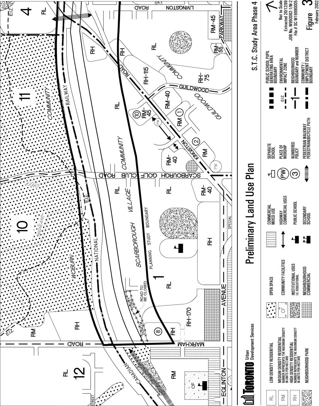
4 4 There is one large privately owned property situated on the northeast corner of Scarborough Golf Club Road and Dale Avenue that is vacant. Official Plan and Zoning By-law Amendment applications proposing 36 townhouses were submitted for this property in October of The applicant appealed these to the Ontario Municipal Board (OMB) in March of 2001 on the basis that Council had not made a decision in the time period required by the Planning Act. In November of 2001, the OMB approved the applications and designated the property Medium Density Residential and zoned it Multiple Family Residential allowing for 36 townhouses. The OMB will issue the final order on this appeal once a site plan agreement is finalized. A site plan application has yet to be submitted for this development. Preliminary Land Use Plan Staff prepared a preliminary land use plan after considering the land use issues raised through the study, the comments of the Working Group and other residents, and City staff. The preliminary land use plan is illustrated on Figure 2. Figure 2 RM NP RL O RM DUNELM STREET DALE RL AVENUE NP RM/RH PRELIMINARY LAND USE PLAN RL LOW DENSITY RESIDENTIAL NP O NEIGHBOURHOOD PARK OPEN SPACE PEDESTRIAN / BICYCLE PATH RM RH MEDIUM DENSITY RESIDENTIAL HIGH DENSITY RESIDENTIAL Staff propose the following land use designations: - Open Space on City-owned lands adjacent to the level rail crossing at Scarborough Golf Club Road that may be grade separated in the future. An Open Space designation may also be appropriate on the watercourse identified by the Toronto Region Conservation Authority (TRCA) on the north side of Dunelm Street. Further consultation is needed with the TRCA to determine the significance of this feature.
5 5 - A Pedestrian/Bicycle Path symbol through the area to provide for a future trail. - Low Density Residential on privately owned developed properties to reflect their current single-family use, and on the smaller City-owned properties on Dunelm Street and Dale Avenue. This would provide for future development of single-detached dwellings on existing lots or on new lots created by severance. - Medium Density Residential on the privately owned property on the northeast corner of Scarborough Golf Club Road and Dale Avenue as approved by the Ontario Municipal Board. - Medium Density Residential on the City-owned property on the northeast corner of Markham Road and Dunelm Street. Neighbourhood Park on the larger City-owned property to the east and the intervening privately owned property on the north side of Dunelm Street. - Medium and/or High Density Residential and Neighbourhood Park on the City-owned properties at Dale Avenue and Kingston Road. The City-owned properties at Markham Road and Dunelm Street and at Dale Avenue and Kingston Road are large enough to accommodate both parkland and townhouses or apartments. These properties are located along arterial roads at the periphery of the community making them suitable for more intensive residential uses. They are also close to transit and other services and facilities, including the Guildwood GO Station on Kingston Road. Existing apartment buildings are adjacent or nearby providing for compatibility of uses. Staff have also prepared urban design guidelines for these properties, to ensure that future development is of high quality. Parkland is proposed adjacent to the existing single-family homes to provide additional parkland for residents and to act as a buffer to the more intensive residential uses. It would be appropriate for the City to examine opportunities for the acquisition of the privately owned property situated between the two larger City-owned properties at Markham Road and Dunelm Street. This would provide for the consolidation of this property with the City-owned lands to the east proposed to be designated Neighbourhood Park. Conclusions: Planning staff have prepared a Discussion Paper for the Scarborough Village portion of the Phase 4 STC Land Use Study that includes a preliminary land use plan. Staff held Community Information Meetings as directed by Council, and a Working Group was established to obtain public input. Comments on the Discussion Paper from other City Departments, agencies, and residents will be sought and considered by staff before preparing the final land use plan. Staff will present a final land use plan and draft Official Plan and Zoning By-law Amendments for Council s consideration in June of 2002.
6 6 Contact: Sue McAlpine, Planner Tel: (416) ; Fax: (416) ; The submits the following report (April 23, 2002) from the Director of Community Planning, East District: Purpose: This report responds to Council's direction to staff to outline the Planning Act procedures required to designate and zone the publicly-held lands in the Scarborough Village portion of the Phase 4 study area as Open Space. Financial Implications and Impact Statement: There are no financial implications resulting from the adoption of this report. Recommendations: It is recommended that this report be received. Background: The land use study for STC Phase 4 was initiated in April of The study area includes the former corridor lands south of the CN rail line, extending from Markham Road to Morningside Avenue, through the Scarborough Village and Guildwood communities. The purpose of the study was to determine the appropriate land use designations and zoning for these lands in consultation with City Departments, agencies, residents and local Councillors. Options for park uses were to be explored, environmental features identified, appropriate levels of development in suitable locations determined, and housing staff were to be consulted for interest in developing new homes on portions of the corridor. Official Plan and Zoning By-law Amendments were approved by Council on February 13, 14, 15, 2002 for the Guildwood portion of the study area. A Status Report on the Scarborough Village portion of the study area was presented to at its meeting on January 29, 2002 and included the following recommendations: That Community Council direct staff to: (1) circulate the Discussion Paper to City Departments, agencies, the Scarborough Village South Community Association, the Working Group, and others requesting a copy; (2) convene a Community Information Meeting in consultation with the Ward Councillor; and;
7 7 (3) prepare a Final Report with recommendations for appropriate land use designations and draft Official Plan and Zoning By-law Amendments for the Scarborough Village portion of the Phase 4 STC Land Use Study; this report to be presented at the Public Meeting of on June 4, 2002, with notice of the Public Meeting to be given by newspaper advertisement and to all persons who requested notice during the study. deferred the Status Report to the February 25, 2002 meeting of Community Council. At its meeting on February 25, 2002 again deferred the Status Report and requested: Comments: That the Director, in consultation with the City Solicitor, report back to Community Council, outlining a procedure under the Planning Act to accomplish an Official Plan and Zoning designation as Open Space, for the publicly-held lands. The City owns 11 properties in the Scarborough Village portion of the study area totalling 8 hectares (19 acres) as shown on Attachment 1. The rest is in private ownership; 41 properties comprising approximately 7 hectares (17 acres). The STC extends through the rear portion of the City and privately owned properties that front on Dunelm Street and Dale Avenue. The STC is identified in the Official Plan as a Special Study Area, with the front portions of these properties designated Low Density Residential. All the properties are zoned Single Family Residential, with the exception of the City-owned property at the east end of Dale Avenue which is zoned Highway Commercial. Through the land use study, staff have explored opportunities for parkland and open space uses on the City-owned properties, as well as options for a trail through the corridor. Staff recommended that the opportunity to develop a trail within the corridor continue to be explored through the completion of the study. Most of the properties along the corridor have depths that exceed 100 metres (300 feet). As a result, there is ample space to develop a trail adjacent to the rail line, and provide for other uses on the remaining land. The development of a continuous trail through the corridor would require the acquisition of private property. This issue was discussed with the residents during the land use study who were opposed to this proposal. In addition, residents living on Dunelm Street submitted a petition opposing a trail through the corridor, citing loss of privacy and safety as main concerns. Planning Act Procedures Official Plan and Zoning By-law Amendments would be required to designate and zone the City-owned properties Open Space. These amendments would follow the same Planning Act procedures required for all Official Plan and Zoning By-law amendments, including:
8 8 A Public Meeting: The Planning Act requires that Council hold a public meeting to consider amendments to the Official Plan and Zoning By-law with notice of the public meeting to be provided at least 20 days prior to the meeting. Notification of the Public Meeting: The Planning Act provides options for notification of public meetings and these include giving notice to all owners within 120 metres of the area to which the amendments apply, posting a notice of the public meeting on the property, or by publication of the public meeting in a newspaper. Notice of the public meeting must also be provided to every person or public body that requested notice of the public meeting. Approximately 300 people have requested notice of public meetings for the Phase 4 STC Land Use Study. Council Adoption of the Official Plan Amendment and Passing the Zoning By-law: Notice of Council s adoption of the Official Plan and Zoning By-law Amendments must be given no later than 15 days from the day Council adopted the amendments to all persons requesting such notice. Appeal Period: A 20 day appeal period applies from the date the notice of the adoption of the amendments was given. Should Council wish to pursue the designation and zoning of the City-owned lands for Open Space, staff require direction with respect to the preparation of the necessary Official Plan and Zoning By-law amendments and the scheduling and notification of the Public Meeting. Related Issues: The Housing First Policy The City s Property Management Committee (PMC) has considered nine of the City-owned properties through its property disposal process. Through this process, the properties were circulated to all City agencies, boards, commissions, departments and the ward councillors to identify any interest in the retention of the properties for municipal purposes. The General Manager of Shelter and Housing Support expressed interest in the three larger City-owned properties for affordable housing under the Housing First Policy. Under the Let s Build program, this would provide for a 25% affordable housing component on these lands. At its meeting on December 10, 1999, the PMC identified these three sites as suitable for development of affordable housing in conformity with the Housing First Policy. However, as the properties were under planning study and were also impacted by the trails study, the PMC recommended that the sites be brought forward for issuance of Request for Expressions of Interest or Requests for Proposals when these studies were completed. No interest was expressed in the retention of the six smaller properties for municipal purposes. The Housing First Policy which was adopted by Council in June of 1999 states, The first priority in the decision making process respecting surplus or potentially surplus City-owned real property should be affordable housing development. A direction to proceed with the Open Space redesignation would have to be reconciled with the Housing First Policy.
9 9 Potential Loss of Revenue Ten of the City-owned properties are currently zoned Single Family Residential with one property zoned Highway Commercial. Through the land use study, planning staff recommended that two City parcels be considered for medium or high density residential uses and seven of the City properties be designated low density residential providing for potentially 13 single family lots (Attachment 2). The designation and zoning of these properties as Open Space would preclude the opportunity to generate revenue from the sale of these lands. Privately Owned Properties The privately owned lands in the STC are also designated Special Study Area. The Discussion paper proposed that this be replaced by a Low Density Residential designation. Should Council instruct staff to redesignate the City-owned lands then it would be necessary to give further instructions regarding the privately owned lands and trail opportunities through this area. Conclusions: Should Council determine that it is appropriate to designate and zone the City-owned properties as Open Space, then staff require direction to prepare the appropriate Official Plan and Zoning By-law Amendments. Planning staff would also require further instructions regarding the privately owned properties and the trail issues identified earlier. The redesignation of these properties to Open Space would be contrary to the determination of the Property Management Committee that these sites have been identified under the Housing First Policy as having the potential for a 25% affordable housing component. Further direction to appropriate City staff would be required to address this issue. Contact: Susan McAlpine, Planner Tel: (416) ; Fax: (416) ; smcalpin@city.toronto.on.ca
10 10 PHASE 4 SCARBOROUGH TRANSPORTATION CORRIDOR LAND USE STUDY SCABOROUGH VILLAGE COMMUNITY Discussion Paper January, 2002 Urban Development Services
11 11 1. INTRODUCTION Scarborough Transportation Corridor The former Scarborough Transportation Corridor (STC) includes lands south the CN rail line through Scarborough that were intended to provide for an extension of the Gardiner expressway. These lands were designated as a Special Study Area in the Official Plan in the mid 1980 s after Council for the former City of Scarborough determined they were no longer needed for transportation purposes. In 1995, the former City of Scarborough initiated a series of land use studies to determine appropriate land use designations for the former corridor lands. The location and status of these land use studies are illustrated on Figure 1. Phase 4 STC Land Use Study The Terms of Reference for the Phase 4 STC Land Use Study were approved by City Council in April of The study area extends approximately 3.5 kilometres from Markham Road to Morningside Avenue through the Scarborough Village and Guildwood communities as shown on the map below. Figure 2 The purpose of the study is to determine appropriate land use designations for this section of the former corridor. A Zoning By-Law review is also being undertaken to determine where changes to the Zoning for the corridor lands may be appropriate. This Discussion Paper is for the Scarborough Village portion of the study area extending from Markham Road to Kingston Road. It includes the background information, the public input, the land use issues reviewed and a preliminary land use plan.
12 12 Urban Development Services Not to Scale 16/12/99 JOB No. W /W-1 File # W96052 Figure 1
13 13 2. BACKGROUND INFORMATION Existing Official Plan Designations The former corridor is designated as a Special Study Area in the Official Plan, as shown on Figure 3. The neighbouring area south of the corridor is predominantly designated Low Density Residential. Apartment buildings at Markham Road and Kingston Road are designated High Density Residential. Existing Zoning The majority of the lands within the study area are zoned Single-Family Residential as shown on Figure 4. One parcel situated north of Dale Avenue at Kingston Road is zoned Highway Commercial, and the apartment buildings at Markham Road and Kingston Road are zoned Apartment and Multiple Family Residential. Land Ownership and Existing Uses Figures 5 and 6 illustrate land ownership and existing land uses within the study area respectively. The study area consists primarily of established low density residential neighbourhoods developed with single-detached dwellings. The City owns several vacant properties within the study area. Smaller City-owned properties are interspersed among privately owned single-family lots on the north side of Dale Avenue and Dunelm Street. Larger City-owned properties are situated at Markham Road and Dunelm Street and at Dale Avenue and Kingston Road. To the south are commercial, apartment and townhouse uses fronting on Kingston Road. Most of the lands north of the rail line comprise the Scarborough Golf and Country Club, with apartment buildings fronting on Markham Road. There is a vacant City-owned property on the east side of Markham Road south the rail line. Commercial uses front Markham Road to the south of this parcel. Recent Development Applications Official Plan and Zoning By-law Amendment applications were submitted in October of 1999 for the privately owned property located at the northeast corner of Scarborough Golf Club Road and Dale Avenue, to permit a 36 unit townhouse development as illustrated on Figure 7. In March of 2001, the applicant appealed these applications to the Ontario Municipal Board (OMB) on the basis that Council had not made a decision in the time period required by the Planning Act. In November of 2001, the OMB approved the applications and designated the property Medium Density Residential and zoned it Multiple-Family Residential allowing for 36 townhouses. The OMB will issue the final order on this appeal once a site plan agreement is finalized. A site plan application has yet to be submitted for this development.
14 14
15 15 Urban Development Services Existing Zoning Phase 4 - S.T.C. Land Use Study File # SC-W S T M Study Boundary Former STC Corridor Single Family Residential Two Family Residential Multiple-Family Residential A HC CC NC Apartment Residential Highway Commercial Community Commercial Neighbourhood Commercial P PW RWY SC Park Place(s) of Worship Railway Corridor School Figure 4 Not to Scale Extracted 1/12/99 - BP
16 16 Urban Development Services Existing Land Ownership Phase 4 - S.T.C. Land Use Study File # SC-W Study Boundary Other Former STC Corridor Canadian National Railway City of Toronto P School Park Figure 5 Not to Scale Extracted 1/12/99 - BP
17 17 Urban Development Services Existing Land Uses Phase 4 - S.T.C. Land Use Study File # SC-W Study Boundary Former STC Corridor Single Family Residential T A MF Townhouse C Commercial W Woodlot Apartment NH Nursing Home P Park Multiple Family Residential PW Place of Worship V Vacant Figure 6 Not to Scale Extracted 1/12/99 - BP
18 18 CANADIAN NATIONAL RAILWAY 44.18m (144.95') 31.12m (102.10') 48.59m (159.42') SCARBOROUGH GOLF CLUB ROAD B L O C K A 3 STOREY TOWNHOUSES 9 UNITS 81.57m (267.62') ONE-WAY ROAD 1.83M HIGH CHAIN-LINK FENCE 2.5M HIGH SAFETY BERM 5.5M HIGH NOISE ATTENUATION WALL ABOVE TOP OF RAIL STREET PARKING ON NORTH SIDE OF ROAD ONE-WAY ROAD B L O C K D 3 STOREY TOWNHOUSES 5 UNITS ONE-WAY LANE B L O C K E 3 STOREY TOWNHOUSES 6 UNITS B L O C K B 3 STOREY TOWNHOUSES 6 UNITS ONE-WAY ROAD B L O C K F 3 STOREY TOWNHOUSES 7 UNITS BLOCK C 3 STOREY TOWNHOUSES 3 UNITS m (385.40') 1 STOREY DWELLING m (419.75') DALE AVENUE Site Plan Applicant's Submitted Drawing Not to Scale 21/12/99 JOB No. Z / Z-2 2 Dale Avenue File # SC-P , SC-Z Figure 7
19 19 3. COMMUNITY CONSULTATION Staff held Community Information Meetings in February of 2000 to introduce the study to the community and obtain public input. A Working Group was then formed consisting of local residents, local Councillors and staff, and a series of Working Group meetings began in May of Land use scenarios were developed by staff and presented to the Working Group for review and discussion. Presentations by staff on the new Official Plan, the Housing First Policy and the Trails study were given to provide information to the Working Group. Staff held additional Community Information Meetings in June of 2000, to update the larger community on the study and obtain further public input. Staff attended meetings in the fall of 2000 organized by residents, and the Scarborough Village South Community Association (SVCSA) meeting in March of 2001 to discuss expanding the scope of the study to include preparing a Community Improvement Plan for the area. The comments received to date are summarized as follows: - Residents prefer that the corridor lands be used as open space or parkland. - Residents oppose medium or high density residential uses in Scarborough Village. - Residents oppose using City-owned properties for affordable housing under the City s Housing First Policy. - Residents have raised issues regarding compatibility, servicing capacities, school capacities, increased traffic and construction traffic in relation to higher density residential uses. - The Working Group submitted a petition requesting that Council not consider the Discussion Paper until such time as a Services Impact Study including school impacts is submitted. - Residents living on the north side of Dunelm Street submitted a petition opposing a public trail in the corridor to the rear of their homes. - A petition signed by 83 residents was submitted opposing the development applications for 36 townhouses at the northeast corner of Scarborough Golf Club Road and Dale Avenue. - Working Group members from Scarborough Village are opposed to the potential future grade separation at the level rail crossing at Scarborough Golf Club Road. - The Scarborough Village South Community Association prefers that the corridor lands in Scarborough Village be considered a biodiversity area.
20 20 - Residents oppose staff s proposal to prepare a Community Improvement Plan for the area. 4. LAND USE ISSUES Introduction The Scarborough Village portion of the study area can be characterized as an established residential community. It is developed primarily with single-detached dwellings with apartment buildings at Markham Road and Dunelm Street and at Kingston Road and Dale Avenue. As such, land uses considered for the former corridor lands within this area were limited to residential, open space and parkland uses. The type of residential uses, the distribution of land uses, the suitability of lands for open space and parkland, and the status of roads and grade separations in this area were identified as issues by staff and residents. Figure 8 illustrates the nature and the location of the land use issues in the study area. Residential Issues Planning staff assessed the corridor lands to determine their appropriateness for low, medium or high density residential uses. Residents are concerned with the potential designation of properties for residential use. They would prefer that the corridor lands be designated open space or parkland or identified as a biodiversity area. There are a number of privately owned lots on the north side of Dunelm Street and Dale Avenue developed with single-detached dwellings, and the corridor extends through the rear yards of these lots. Staff recommends that the corridor lands on these properties be designated Low Density Residential to reflect the existing single-family uses and Low Density Residential designations on the frontage of these properties. The smaller City-owned properties on the north side of Dunelm Street and Dale Avenue are similar in size to the existing developed single-family properties along these streets. Staff recommend that these City-owned properties be designated Low Density Residential. This designation would provide for the future development of single-family dwellings on appropriately sized lots, or through severance to create additional lots. There are also City-owned properties north of Dunelm Street that do not have direct frontage on the public street. Staff recommends designating these lands Low Density Residential providing for the consolidation of these lands with adjacent properties. There is some community support for a Low Density Residential designation on these properties. Staff consider the larger City-owned properties at Markham Road and Dunelm Street and at Dale Avenue and Kingston Road suitable for more intensive residential uses. The property at Markham Road and Dunelm Street is approximately 1.2 hectares (3 acres) in size, and the property at Dale Avenue and Kingston Road is approximately 2 hectares (5 acres) in size. These
21 21 properties are large and configured appropriately for townhouses or apartments. They are suitable sites for more intensive residential uses due to their location at the periphery of the community along arterial roads. They are close to the Guildwood GO Station and to other community services and facilities on Kingston Road. In addition, apartments are adjacent to these sites providing compatibility of uses.
22 22 -Residential Intensification -Urban Design -Housing First Policy -Parkland Offroad Bicycle/ Pedestrian Trail Grade Separation -Residential Intensification -Urban Design -Housing First Policy -Parkland Issues Urban Development Services Phase 4 - S.T.C. Land Use Study File # SC-W P Study Boundary School Park Figure 8 Not to Scale June, 2000
23 23 The Official Plan provides for a maximum of 100 units per hectare (40 units per acre) in Medium Density Residential designations and 150 units per hectare (60 units per acre) in High Density Residential designations. A medium or high density residential designation on these sites would provide for approximately 100 units at Markham Road and Dunelm Street and approximately 150 units at Dale Avenue and Kingston Road. Residents are opposed to medium or high density residential uses on these sites. Compatibility, increased traffic, the capacity of local schools and municipal services, and the potential for affordable housing to be built on City-owned properties under the City s Housing First Policy are issues of concern to the residents. These issues are explored below. (a) Compatibility In order to address the issue of compatibility between low density and medium or high density residential uses on the City-owned sites, staff have prepared Urban Design Guidelines for these properties. The Guidelines address site organization, access, massing of buildings, streetscape treatment, landscaping, open space, and safety. Future development proposals for these sites would be assessed with respect to the Guidelines to ensure that a high standard of development is achieved. The Urban Design Guidelines are included as Appendix 1 to this paper. (b) Schools Cedar Drive Public School is located in this area south of the former corridor lands. The Boards of Education were circulated a request for comments on the land use study. Although no formal responses have been received to date, staff understand that Cedar Drive Public School is currently operating at capacity. Staff will address the issue of school capacity with the School Board and report back to Council on this issue. (c) Municipal Services Any new development within this area will require municipal water, sanitary sewer and storm sewer services. To date, no issues have been raised by Works and Emergency Services (WES) staff with respect to existing services in this area. Additional opportunity will be provided to WES staff to comment on the preliminary land use plan through the circulation of the Discussion Paper. (d) City s Housing First Policy Staff from the Community and Neighbourhood Services Department have indicated that the larger City-owned properties are of interest for the provision of affordable housing under the City s Housing First Policy. Residents are opposed to the application of the Housing First Policy on these lands. Concerns relate to the existing amount of social housing and lower end market rental housing in this area, and the impacts of affordable housing on the community.
24 24 The issue of housing affordability is an important City-wide issue. Although the tenure of residential uses cannot be designated in the Official Plan, the Official Plan policies promote the provision of a range of housing types and densities to meet a range of community needs. The City-owned properties provide an opportunity for the development of affordable housing under the City s Housing First Policy. (e) Traffic Study Staff conducted a traffic study to assess the potential impact of additional residential development in this area, if all sites identified as suitable for residential use were developed to their highest potential. The study found that existing traffic levels are not excessive, and additional residential development would not significantly impact this community. Traffic concerns continue to be a significant issue for residents. Members of the Working Group from Scarborough Village put forward a proposal to close Scarborough Golf Club Road from the CN rail line north to Mazaryktown as a means of traffic calming in this neighbourhood. This proposal has been reviewed by WES and Planning staff. Closing Scarborough Golf Club Road to through traffic other than emergency vehicles would require a full Environmental Assessment (EA). If closure were recommended through the EA process, then Council could consider an Official Plan Amendment to delete the road from the Official Plan. Staff do not support the proposal to close this road. Parkland Issues Historically, Scarborough Village was identified as an area within the former City of Scarborough where additional parkland was required. The current approach to assessing parkland also indicates that parkland levels in Scarborough Village are low when examined on a Citywide basis. Staff assessed the corridor lands to determine their suitability for parkland. Property size and configuration are important considerations for parkland as small or narrow properties are not adequate for the construction of play equipment or sport fields. The larger properties at Markham Road and Dunelm Street and Kingston Road and Dale Avenue provide the best opportunity for parkland in this community. These are also the locations where medium and high density residential uses are considered appropriate. There is sufficient land is these locations to provide additional parkland in this community and provide for residential uses. The lands adjacent to the existing residential areas are appropriate locations for parkland as this would provide a buffer between existing single-detached homes and possible future higher density residential uses. Some residents support the designation of these lands entirely for park purposes. There is a private property situated between the two larger City-owned properties at Markham Road and Dunelm Street. It would be appropriate to examine opportunities for the acquisition of this property to provide for a consolidated development with adjacent City-owned property. Residents would prefer that this property be designated parkland.
25 25 Open Space Issues The Toronto and Region Conservation Authority (TRCA) has advised that a small watercourse traverses a portion of the corridor lands on the north side of Dunelm Street west of Scarborough Golf Club Road, and they recommend the protection of this watercourse. It appears however, that this watercourse has been altered with filling. Staff will consult further with the TRCA to determine the significance of this watercourse. One of the objectives of the land use study is the designation of a bicycle\pedestrian trail through this area and residents support this. However, residents along Dunelm Street are opposed to a public trail on the corridor lands through the rear yard of their properties. A combination on-road and off-road trail can be developed in this area. The Scarborough Village South Community Association has put forward the position that the corridor lands in Scarborough Village be designated as a biodiversity area. The City and the TRCA are undertaking a Natural Heritage System Study for the City. The information provided through this study will be used to assist staff in developing the Natural Heritage policies for the City s new Official Plan. The Phase 4 STC lands were evaluated by the TRCA in the context of the Natural Heritage System Study. No additional features of environmental significance were identified in the Scarborough Village portion of the Phase 4 study area through this evaluation. Roads Issues In the past, staff considered options to extend Livingston Road under the Kingston Road overpass to connect to Dale Avenue. WES staff have advised that there are no current plans to extend this roadway, and they do not anticipate bringing this new road forward as a City-initiated project. When the original expressway was proposed staff anticipated that Dunelm Street would be closed, and this is noted in the Official Plan. Staff recommends that the reference to the closure of Dunelm Street be removed from the Official Plan. Grade Separations The level rail crossing at Scarborough Golf Club Road is identified in the Official Plan as a crossing to be improved. WES staff reviewed level rail crossings within the City to determine their exposure indices. The exposure index measures the average annual daily traffic by the number of trains passing per day, and is one factor used in setting priorities for grade separation construction. The level rail crossing at Scarborough Golf Club Road has the highest exposure index in the City, indicating that this level rail crossing is likely to be grade separated in the future. There are no immediate plans to construct a grade separation at this level rail crossing. However, the protection of lands in the vicinity of this level rail crossing is important to provide for a future grade separation. Staff recommends that the City-owned property on the west side of Scarborough Golf Club Road be designated Open Space to provide for this potential grade separation.
26 26 Members of the Working Group from Scarborough Village are opposed to the grade separation of Scarborough Golf Club Road and the rail-line. 5. PRELIMINARY LAND USE PLAN Introduction Staff have prepared a preliminary land use plan after considering the land use issues identified through the study, the comments of the Working Group and other residents, and City staff. Staff believe that the preliminary land use plan provides for appropriate land use designations for the Phase 4 STC lands in the Scarborough Village Community. The preliminary land use plan is illustrated on Figure 9, and the land use designations are proposed as follows: (a) Low Density Residential - Private properties currently developed with single-detached dwellings on Dunelm Street and Dale Avenue - Smaller City-owned properties on Dunelm Street and Dale Avenue (approximately 13 single-family lots) (b) Medium Density Residential - City-owned property at the northeast corner of Dunelm Street and Markham Road (approximately 100 units) - Private property on the northeast corner of Scarborough Golf Club Road and Dale Avenue (36 townhouses) (c) Medium and/or High Density Residential - City-owned property on the north side of Dale Avenue at Kingston Road (approximately 150 units) (d) Neighbourhood Park - City-owned lands on Dunelm Street east of Markham Road (1 hectare (2.5acres)) - City-owned lands on the north side of Dale Avenue west of Kingston Road (1 hectare (2.5 acres)) - Privately owned property on Dunelm Street near Markham Road (0.3 hectares (0.7 acres))
27 27 (e) Open Space - City-owned property on the west side of Scarborough Golf Club Road (0.5 hectares (1.3 acres)) (f) Pedestrian/Bicycle Path - A pedestrian/bicycle path symbol is proposed through the area (g) Road Closures Comments - Reference to the closure of Dunelm Street would be removed The preliminary land use plan reflects the current use of the properties or adjacent uses where this is appropriate from a land use perspective. A Low Density Residential designation is appropriate for the existing single-family lots and the smaller City-owned properties on the north side of Dunelm Street and Dale Avenue. This designation recognizes the existing single-family uses and is a natural extension of the Low Density Residential designation currently on the frontage of these properties. A Medium Density Residential designation is shown on the private property on the northeast corner of Scarborough Golf Club Road and Dale Avenue. This property was designated by the Ontario Municipal Board in November of 2001 allowing for 36 townhouses. Staff propose a Medium Density Residential designation on the City-owned property on the northeast corner of Markham Road and Dunelm Street. A Neighbourhood Park designation is proposed on the City-owned property to the east of this parcel. There is a smaller privately owned property situated between the two larger City-owned properties on Dunelm Street. Due to its location, staff recommends that the City examine opportunities for the acquisition of this private property to provide for its consolidation with adjacent City-owned property. Residents would prefer that this property be designated park in conjunction with the City-owned property to the east that staff propose be designated Neighbourhood Park. Staff propose a Neigbourhood Park designation on this property to provide a buffer between the more intensive residential uses proposed to the west and existing low density residential uses on Dunelm Street.
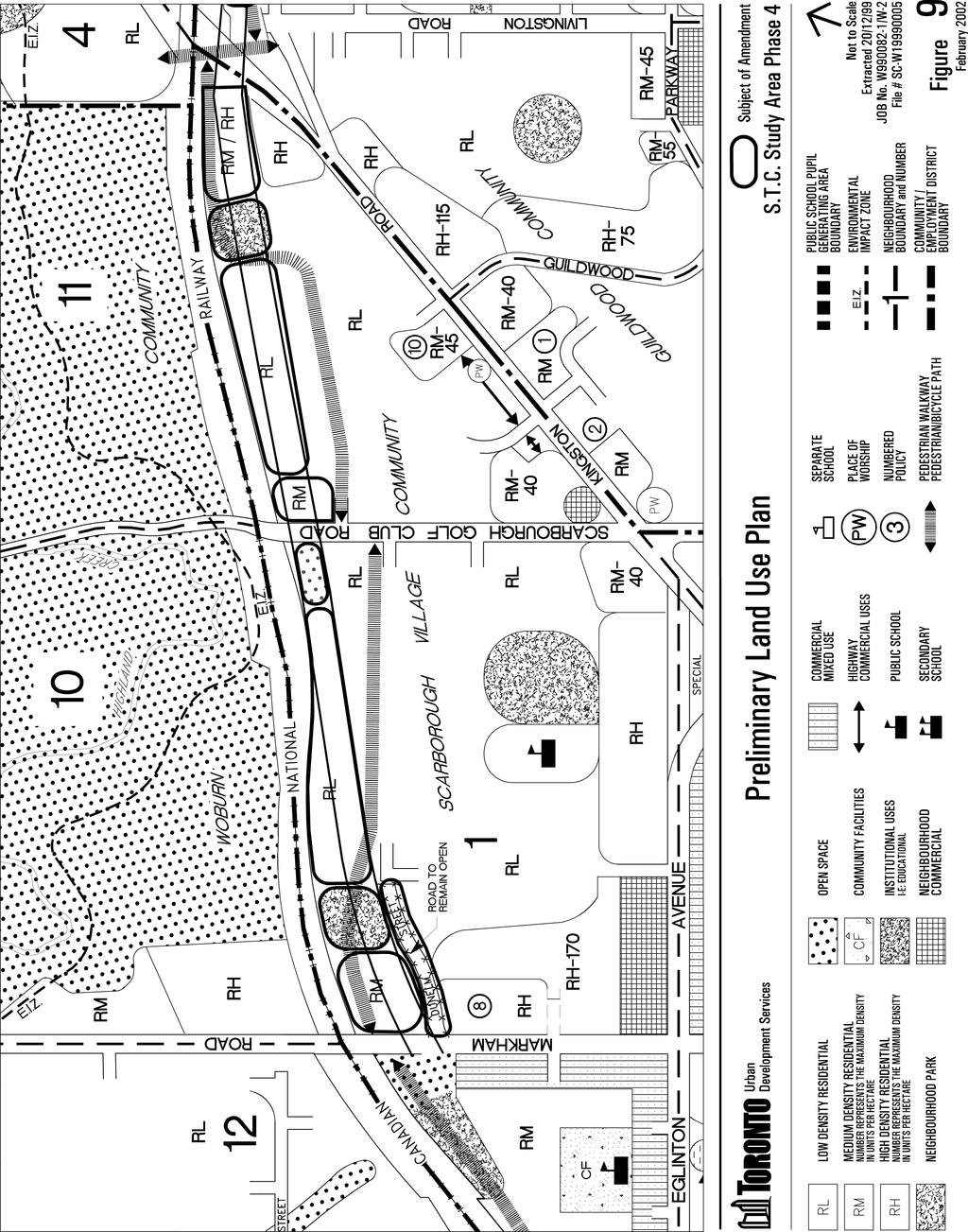
28 28
29 29 For the larger City-owned properties at Dale Avenue and Kingston Road, staff propose a combination of Neighbourhood Park and Medium and High Density Residential designations. The larger City owned properties are of sufficient size and appropriate configuration to allow for the development of a number of residential units and provide parkland. The Guildwood GO Station is accessible from this area providing for public transit. The intensification of residential uses near major transit facilities is also important to reduce automobile dependency and pollution. These properties are located along arterial roadways at the periphery of the community close to services and facilities on Kingston Road. In addition, apartments are located adjacent or nearby, providing for compatibility of uses. Urban Design Guidelines are also proposed to ensure that future development is of a high standard. Neighbourhood Park designations are proposed to provide additional parkland for this community and to separate and buffer the existing low density community from more intensive residential uses. The traffic study indicates that traffic generated from these residential uses will not be excessive or significantly impact the community. Staff propose to add a bike/pedestrian trail symbol to the Official Plan through the area to provide for the future development of a combination on-road and off-road trail. This provides the connection needed to link with the future trail identified in the Official Plan west of Markham Road. Zoning By-Law Review Staff have reviewed the Zoning By-law to determine where changes are appropriate. Changes are appropriate in situations where the current zoning is not consistent with the use of the land or with the proposed land use designation. At this time, changes to the Zoning By-Law would be appropriate as follows: (a) (b) (c) The property on the north side of Dale Avenue at Kingston Road is currently zoned Highway Commercial. A rezoning of this property to reflect the proposed land use designations would be appropriate. A Zoning By-law Amendment is required on the lands at Markham Road and Dunelm Street to reflect the proposed land use designation in this area. The City-owned lands on the west side of Scarborough Golf Club Road are zoned Single Family Residential. An Open Space zone category would be appropriate to provide for public works that may be required in association with a grade separation at this location. More detailed zone provisions will be required to implement the proposed land use designations. Staff recommends that the more detailed zone provisions be developed based on the Urban Design Guidelines presented in Appendix 1, in consultation with the Ward Councillor and residents.
30 30 6. NEXT STEPS To complete the Phase 4 STC Land Use Study for the Scarborough Village Community, the following steps are proposed: - That the Discussion Paper be circulated for comment to City Departments and other technical agencies. - That the Discussion Paper be circulated for comment to the Working Group, the Scarborough Village South Community Association, the local Councillor and other individuals requesting copies of this paper. - That a Community Information Meeting be held to obtain the input of the larger community on the Discussion Paper. - That the Public Meeting to consider the draft Official Plan and Zoning By-law Amendments be held at the June 4, 2002 meeting of. - That notice of the Public Meeting be advertised by newspaper and sent to all persons who requested notice during the study. - That a Recommendation Report be prepared which considers the community input, agency and Department comments. This report would also include the proposed Official Plan and Zoning By-Law Amendments. Site Organization Policy APPENDIX 1 URBAN DESIGN GUIDELINES New residential units should use existing city streets for access and address. If new streets are required, they should be extended and integrated with the City s public street system. Guidelines 1. New development should be sited and organized to: (a) (b) (d) use existing streets for address and access wherever possible provide extensions to existing street patterns, laneways and sidewalks to create strong physical and visual links between existing and new development avoid gated communities and dead end streets
31 31 (e) front units onto existing or newly created streets with no back-to-front facing relationships Access Policy Organize buildings and site plans to minimize the impact of parking and servicing function on streets and accessible open space. Guidelines 1. In new development: (a) (b) (c) (d) (e) locate loading, garbage and other services so that they do not have a negative impact on the development or adjacent neighbourhoods these areas should be screened, fenced or properly landscaped to mitigate negative effects consolidate servicing and parking areas where appropriate locate access to servicing to the rear of the site or from a private lane minimize number and width of curb cuts on the site Massing Policy New development should provide building continuity to frame streets and open spaces. Appropriate setbacks from property lines and building faces should ensure adequate light, view and privacy conditions. Locate the primary façade of buildings parallel to the street with a consistent setback from the property line. Guidelines 1. New development should be: (a) (b) (c) architecturally interesting and should consist of a clear base building, a strong cornice line, and an articulated roof contain banding or architectural treatment to add definition between storeys consist of vertical and horizontal elements on the façade that repeats, to give the street unity and coherence, have main entrances facing the street rather from parking spaces or driveways
32 32 (d) contain proportionate solid wall to fenestration ratio Streetscape Policy Provide streetscape improvements that include planting, paving and lighting. Streetscapes should provide for pedestrian comfort and safety in the development. Guidelines 1. In order to improve streetscapes, new development should: (a) (b) (c) minimize the amount of hard surface paving in the street and on private lots used for vehicles or storage maximize the amount of the street and private lots not used for building to provide soft landscaping provide adequate lighting, to public standards, for sidewalks adjacent to private roads, along pathways, throughout parking areas or lanes Landscape/Open Space Policy Site buildings at the edge of parks and open spaces to provide enclosure, overlook and connections to the public street system. Provide landscape elements that reinforce and compliment the general development and are sustainable, attractive, and functional. Street tree plantings and appropriate landscaping of individual buildings are essential elements of development proposals. Provide necessary and adequate acoustical barriers and landscaping to mitigate the impact of the adjacent rail line. Guidelines 1. New development should be sited and organized to: (a) (b) (c) (d) provide private open space that maximizes amenity, visibility and sun conditions provide uses at-grade that encourage activity related to the open space locate site uses such as landscaped areas, patios and private open space next to each other preserve and protect existing healthy trees and green space
Phase 4: Scarborough Transportation Corridor Land Use Study - Scarborough Village Community Final Report
 STAFF REPORT ACTION REQUIRED Phase 4: Scarborough Transportation Corridor Land Use Study - Scarborough Village Community Final Report Date: April 24, 2013 To: From: Wards: Reference Number: Scarborough
111 Wenderly Drive Official Plan and Zoning By-law Amendment Applications - Preliminary Report
 STAFF REPORT ACTION REQUIRED 111 Wenderly Drive Official Plan and Zoning By-law Amendment Applications - Preliminary Report Date: August 17, 2015 To: From: Wards: Reference Number: North York Community
3035 Weston Road - Official Plan and Zoning By-law Amendment and Draft Plan of Subdivision Applications - Request for Directions Report
 STAFF REPORT ACTION REQUIRED 3035 Weston Road - Official Plan and Zoning By-law Amendment and Draft Plan of Subdivision Applications - Request for Directions Report Date: December 18, 2007 To: From: Wards:
39 Thora Avenue Zoning Amendment Application Preliminary Report
 STAFF REPORT ACTION REQUIRED 39 Thora Avenue Zoning Amendment Application Preliminary Report Date: January 28, 2014 To: From: Wards: Reference Number: Scarborough Community Council Director, Community
3390, 3392, 3394, 3396 and 3398 Bayview Avenue - Official Plan Amendment, Zoning By-law Amendment Application - Preliminary Report
 STAFF REPORT ACTION REQUIRED 3390, 3392, 3394, 3396 and 3398 Bayview Avenue - Official Plan Amendment, Zoning By-law Amendment Application - Preliminary Report Date: March 14, 2016 To: From: Wards: Reference
1417, , 1427 & 1429 Yonge Street - Official Plan Amendment and Zoning Amendment Applications - Preliminary Report
 STAFF REPORT ACTION REQUIRED 1417, 1421-1425, 1427 & 1429 Yonge Street - Official Plan Amendment and Zoning Amendment Applications - Preliminary Report Date: March 24, 2015 To: From: Wards: Reference Number:
STAFF REPORT. September 25, City Council. Chief Planner and Executive Director, City Planning Division
 STAFF REPORT September 25, 2006 To: From: Subject: City Council Chief Planner and Executive Director, City Planning Division Request for Directions Report Toronto & East York Community Council, Report
1555 Midland Avenue - Zoning Amendment & Subdivision Applications - Preliminary Report
 STAFF REPORT ACTION REQUIRED 1555 Midland Avenue - Zoning Amendment & Subdivision Applications - Preliminary Report Date: October 24, 2013 To: From: Wards: Reference Number: Scarborough Community Council
Director, Community Planning, Toronto and East York District
 STAFF REPORT September 1, 2005 To: From: Subject: Toronto and East York Community Council Director, Community Planning, Toronto and East York District Further Report Applications to amend Official Plan
4121 Kingston Road Zoning Amendment Application - Preliminary Report
 STAFF REPORT ACTION REQUIRED 4121 Kingston Road Zoning Amendment Application - Preliminary Report Date: August 15, 2012 To: From: Wards: Reference Number: Scarborough Community Council Acting Director,
Director, Community Planning, Scarborough District ESC 44 OZ & ESC 44 SB
 STAFF REPORT ACTION REQUIRED 6175, 6183 Kingston Road and 1, 2, 4, 5, 7,10 & 11 Franklin Avenue - Official Plan Amendment, Zoning Amendment and Draft Plan of Subdivision Applications Preliminary Report
PIN , Part 1, Plan SR-713 in Lot 2, Concession 5, Township of McKim (1096 Dublin Street, Sudbury)
") STAFF REPORT Applicant: Dalron Construction Limited Location: PIN 02124-0103, Part 1, Plan SR-713 in Lot 2, Concession 5, Township of McKim (1096 Dublin Street, Sudbury) Official Plan and Zoning By-law:
STAFF REPORT Applicant: Dalron Construction Limited Location: PIN 02124-0103, Part 1, Plan SR-713 in Lot 2, Concession 5, Township of McKim (1096 Dublin Street, Sudbury) Official Plan and Zoning By-law:
Islington Avenue - Official Plan and Zoning By-law Amendment Application - Preliminary Report
 STAFF REPORT ACTION REQUIRED 3002-3014 Islington Avenue - Official Plan and Zoning By-law Amendment Application - Preliminary Report Date: Febuary 2, 2016 To: From: Wards: Reference Number: Etobicoke York
12, 14, 16 and 18 Marquette Avenue and 7 Carhartt Street Zoning By-law Amendment Application - Preliminary Report
 STAFF REPORT ACTION REQUIRED 12, 14, 16 and 18 Marquette Avenue and 7 Carhartt Street Zoning By-law Amendment Application - Preliminary Report Date: July 17, 2014 To: From: Wards: Reference Number: North
Director, Community Planning, North York District
 STAFF REPORT ACTION REQUIRED 1-35, 45-69 and 6-66 Adra Villaway, 1-25, 2-24, 30-44 and 37-53 Grado Villaway, 1-29 and 2-28 Tomar Villaway Official Plan and Zoning By-law Amendment Applications and Rental
Director, Community Planning, North York District NNY 10 OZ and NNY 10 RH
 STAFF REPORT ACTION REQUIRED 847 873 Sheppard Avenue West - Official Plan Amendment and Zoning By-law Amendment and Rental Housing Demolition and Conversion Applications - Preliminary Report Date: April
STAFF REPORT. March 14, Toronto and East York Community Council. Director, Community Planning, South District
 STAFF REPORT March 14, 2005 To: From: Subject: Toronto and East York Community Council Director, Community Planning, South District Preliminary Report Official Plan Amendment and Rezoning Application 05
1202 & 1204 Avenue Road Zoning By-law Amendment Application - Preliminary Report
 STAFF REPORT ACTION REQUIRED 1202 & 1204 Avenue Road Zoning By-law Amendment Application - Preliminary Report Date: March 17, 2017 To: From: Wards: Reference Number: North York Community Council Director,
Acting Director, Community Planning, Toronto and East York District
 STAFF REPORT ACTION REQUIRED 620 Avenue Road, 215 & 217 Lonsdale Road OPA & Rezoning Application Preliminary Report Date: March 13, 2008 To: From: Wards: Reference Number: Toronto and East York Community
Yonge Street, 5-9 St. Joseph Street and 11-19, 25 St. Nicholas Street Rezoning Application - Preliminary Report
 STAFF REPORT ACTION REQUIRED 606-618 Yonge Street, 5-9 St. Joseph Street and 11-19, 25 St. Nicholas Street Rezoning Application - Preliminary Report Date: December 11, 2008 To: From: Wards: Reference Number:
111 Plunkett Road (formerly part of 135 Plunkett Road) - Zoning By-law Amendment Application and Plan of Subdivision Application - Preliminary Report
 - Zoning By-law Amendment Application and Plan of Subdivision Application - Preliminary Report") STAFF REPORT ACTION REQUIRED 111 Plunkett Road (formerly part of 135 Plunkett Road) - Zoning By-law Amendment Application and Plan of Subdivision Application - Preliminary Report Date: May 27, 2013 To:
STAFF REPORT ACTION REQUIRED 111 Plunkett Road (formerly part of 135 Plunkett Road) - Zoning By-law Amendment Application and Plan of Subdivision Application - Preliminary Report Date: May 27, 2013 To:
25 Leonard Avenue - Official Plan Amendment and Zoning Amendment Applications - Preliminary Report
 STAFF REPORT ACTION REQUIRED 25 Leonard Avenue - Official Plan Amendment and Zoning Amendment Applications - Preliminary Report Date: March 8, 2017 To: From: Wards: Reference Number: Toronto and East York
Director, Community Planning, Etobicoke York District
 STAFF REPORT ACTION REQUIRED 3555 Don Mills Road Zoning By-law Amendment Application Preliminary Report Date: May 22, 2012 To: From: Wards: Reference Number: North York Community Council Director, Community
Bathurst Street Zoning Amendment Application and Rental Housing Demolition Application under Municipal Code Chapter 667 Final Report
 STAFF REPORT ACTION REQUIRED 1996-2000 Bathurst Street Zoning Amendment Application and Rental Housing Demolition Application under Municipal Code Chapter 667 Final Report Date: January 26, 2017 To: Toronto
LITTLE MOUNTAIN ADJACENT AREA REZONING POLICY
 LITTLE MOUNTAIN ADJACENT AREA REZONING POLICY JANUARY 2013 CONTENTS 1.0 INTENT & PRINCIPLES...1 2.0 APPLICATION...2 3.0 HOUSING TYPES, HEIGHT & DENSITY POLICIES...3 3.1 LOW TO MID-RISE APARTMENT POLICIES...4
Yonge Street and 3 Gerrard Street East - Zoning Amendment Application - Preliminary Report
 STAFF REPORT ACTION REQUIRED 363-391 Yonge Street and 3 Gerrard Street East - Zoning Amendment Application - Preliminary Report Date: May 22, 2015 To: From: Wards: Reference Number: Toronto and East York
3.1. OBJECTIVES FOR RESIDENTIAL LAND USE DESIGNATIONS GENERAL OBJECTIVES FOR ALL RESIDENTIAL DESIGNATIONS
 3. RESIDENTIAL LAND USE DESIGNATIONS INTRODUCTION The Residential land use designations provide for housing and other land uses that are integral to, and supportive of, a residential environment. Housing
200 St. Clair Ave W - Official Plan Amendment and Zoning Amendment Applications - Preliminary Report
 STAFF REPORT ACTION REQUIRED 200 St. Clair Ave W - Official Plan Amendment and Zoning Amendment Applications - Preliminary Report Date: December 15, 2014 To: From: Wards: Reference Number: Toronto and
1970 Victoria Park Avenue and 9 Clintwood Gate Zoning By-law Amendment Application Preliminary Report
 STAFF REPORT ACTION REQUIRED 1970 Victoria Park Avenue and 9 Clintwood Gate Zoning By-law Amendment Application Preliminary Report Date: September 23, 2013 To: From: Wards: Reference Number: North York
230 Oak Street- Official Plan Amendment and Zoning Bylaw Amendment Applications - Preliminary Report
 STAFF REPORT ACTION REQUIRED 230 Oak Street- Official Plan Amendment and Zoning Bylaw Amendment Applications - Preliminary Report Date: February 6, 2014 To: From: Wards: Reference Number: Toronto and East
250, 252, 254 and 256 Royal York Road and 8 and 10 Drummond Street - Zoning By-law Amendment Application - Preliminary Report
 STAFF REPORT ACTION REQUIRED 250, 252, 254 and 256 Royal York Road and 8 and 10 Drummond Street - Zoning By-law Amendment Application - Preliminary Report Date: May 28, 2013 To: From: Wards: Reference
Director, Community Planning, North York District
 STAFF REPORT ACTION REQUIRED 3, 5, 11, 17, 21 Allenbury Gardens & 3, 5 Kingslake Road Official Plan and Zoning By-law Amendment and Rental Housing Demolition Applications Final Report Date: February 6,
4027 and 4031 Ellesmere Road Zoning Amendment and Draft Plan of Subdivision Applications - Request for Direction Report
 STAFF REPORT ACTION REQUIRED 4027 and 4031 Ellesmere Road Zoning Amendment and Draft Plan of Subdivision Applications - Request for Direction Report Date: August 22, 2013 To: From: Wards: Reference Number:
Update on the Avenues and Mid-Rise Buildings Action Plan
 STAFF REPORT INFORMATION ONLY Update on the Avenues and Mid-Rise Buildings Action Plan Date: May 15, 2009 To: From: Wards: Reference Number: Planning and Growth Management Committee Chief Planner and Executive
Kingston Road - Zoning Amendment and Draft Plan of Subdivision Applications - Preliminary Report
 STAFF REPORT ACTION REQUIRED 6480-6484 Kingston Road - Zoning Amendment and Draft Plan of Subdivision Applications - Preliminary Report Date: April 19, 2016 To: From: Wards: Reference Number: Scarborough
Toronto and East York Community Council. Director, Community Planning, Toronto and East York District
 STAFF REPORT ACTION REQUIRED 1481, 1491, 1501 Yonge Street, 25 & 27 Heath Street East and 30 Alvin Avenue Official Plan and Zoning Amendment Application 06 199698 STE 22 OZ Preliminary Report Date: March
8.5.1 R1, Single Detached Residential District
 8.5.1 R1, Single Detached Residential District The purpose of this district is to provide for residential development in the form of single detached dwellings. Dwelling, Single Detached Home Business,
Galloway Road and 4097 Lawrence Avenue East - Zoning Amendment Application - Preliminary Report
 STAFF REPORT ACTION REQUIRED 197-201 Galloway Road and 4097 Lawrence Avenue East - Zoning Amendment Application - Preliminary Report Date: November 29, 2013 To: From: Wards: Reference Number: Scarborough
50 and 52 Finch Avenue East - Official Plan and Zoning By-law Amendment Applications - Preliminary Report
 STAFF REPORT ACTION REQUIRED 50 and 52 Finch Avenue East - Official Plan and Zoning By-law Amendment Applications - Preliminary Report Date: August 16, 2016 To: From: Wards: Reference Number: North York
3 and 5 Southvale Dr - Official Plan Amendment and Zoning Amendment Applications - Preliminary Report
 STAFF REPORT ACTION REQUIRED 3 and 5 Southvale Dr - Official Plan Amendment and Zoning Amendment Applications - Preliminary Report Date: August 20, 2015 To: From: Wards: Reference Number: North York Community
5 to 25 Wellesley Street West and 14 to 26 Breadalbane Street - Zoning Amendment Application - Preliminary Report
 STAFF REPORT ACTION REQUIRED 5 to 25 Wellesley Street West and 14 to 26 Breadalbane Street - Zoning Amendment Application - Preliminary Report Date: May 16, 2013 To: From: Wards: Reference Number: Toronto
CITY OF VAUGHAN EXTRACT FROM COUNCIL MEETING MINUTES OF DECEMBER 11, 2012
 Item 6, Report No. 50, of the Committee of the Whole (Public Hearing), which was adopted, as amended, by the Council of the City of Vaughan December 11, 2012, as follows: By receiving Communication C1
50 and 52 Neptune Drive Rezoning Preliminary Report
 STAFF REPORT ACTION REQUIRED 50 and 52 Neptune Drive Rezoning Preliminary Report Date: February 11, 2010 To: From: Wards: Reference Number: North York Community Council Director, Community Planning, North
Infrastructure, Development and Enterprise Services
 Staff Report To Service Area City Council Infrastructure, Development and Enterprise Services Date Monday, April 9, 2018 Subject Report Number Statutory Public Meeting 671 Victoria Road North Proposed
507, 509 and 511 Kingston Road - Official Plan and Zoning By-law Amendment Applications - Preliminary Report
 STAFF REPORT ACTION REQUIRED 507, 509 and 511 Kingston Road - Official Plan and Zoning By-law Amendment Applications - Preliminary Report Date: March 9, 2017 To: From: Wards: Reference Number: Toronto
Richmond Street West - Zoning Amendment Application Final Report
 STAFF REPORT ACTION REQUIRED 842-856 Richmond Street West - Zoning Amendment Application Final Report Date: May 24, 2012 To: From: Wards: Reference Number: Toronto and East York Community Council Director,
25 St. Dennis Drive - Zoning By-law Amendment Application - Preliminary Report
 STAFF REPORT ACTION REQUIRED 25 St. Dennis Drive - Zoning By-law Amendment Application - Preliminary Report Date: February 4, 2016 To: From: Wards: Reference Number: North York Community Council Director,
40 Moccasin Trail and 50 Green Belt Drive - OMB
 REPORT FOR ACTION 40 Moccasin Trail and 50 Green Belt Drive - OMB Date: March 21, 2017 To: City Council From: City Solicitor Wards: Ward 34 SUMMARY The purpose of this report is to request further direction
Appendix1,Page1. Urban Design Guidelines. Back to Back and Stacked Townhouses. DRAFT September 2017
 Appendix1,Page1 Urban Design Guidelines DRAFT September 2017 Back to Back and Stacked Townhouses Appendix1,Page2 Table of Contents 1 Introduction 1 1.1 Purpose 1 1.2 Urban Design Objectives 1 1.3 Building
Urban Design Brief Dundas Street. London Affordable Housing Foundation. November Zelinka Priamo Ltd.
 Urban Design Brief 1039-1047 Dundas Street London Affordable Housing Foundation November 2017 Zelinka Priamo Ltd. TABLE OF CONTENTS Page No. INTRODUCTION... 3 SECTION 1 LAND USE PLANNING CONTEXT... 3 1.1
836 St Clair Ave W - Zoning Amendment Application - Preliminary Report
 STAFF REPORT ACTION REQUIRED 836 St Clair Ave W - Zoning Amendment Application - Preliminary Report Date: October 24, 2013 To: From: Wards: Reference Number: Toronto and East York Community Council Director,
Paul D. Ralph, BES, RPP, MCIP, Commissioner, Development Services Department
 Public Report To: From: Report Number: Development Services Committee Paul D. Ralph, BES, RPP, MCIP, Commissioner, Development Services Department DS-16-50 Date of Report: April 14, 2016 Date of Meeting:
Staff Report for Council Public Meeting
 Agenda Item 3.3 Staff Report for Council Public Meeting Date of Meeting: September 27, 2017 Report Number: SRPRS.17.134 Department: Division: Subject: Planning and Regulatory Services Development Planning
Financial Impact Statement There are no immediate financial impacts associated with the adoption of this report.
 STAFF REPORT Planning and Development Department Subject: Application by RYC Property to rezone a portion of lands on John Murray Dr. and Megan Lynn Dr. from R2 to R3 and to enter into a Development Agreement
STAFF REPORT. January 25, North York Community Council. Director, Community Planning, North District
 STAFF REPORT January 25, 2005 To: From: Subject: Purpose: North York Community Council Director, Community Planning, North District Refusal Report OPA & Rezoning Application 04 194214 NNY 33 OZ Applicant:
250 Lawrence Avenue West - Official Plan and Zoning By-law Amendment Applications Preliminary Report
 STAFF REPORT ACTION REQUIRED 250 Lawrence Avenue West - Official Plan and Zoning By-law Amendment Applications Preliminary Report Date: April 22, 2015 To: From: Wards: Reference Number: North York Community
Plan Dutch Village Road
 Plan Dutch Village Road Objective: The lands around Dutch Village Road are a minor commercial area that services the larger Fairview community. Maintaining the vibrancy of the area by planning for redevelopment
740 and 750 York Mills Road and 17 Farmstead Road Zoning By-law Amendment Application Preliminary Report
 STAFF REPORT ACTION REQUIRED 740 and 750 York Mills Road and 17 Farmstead Road Zoning By-law Amendment Application Preliminary Report Date: September 20, 2013 To: From: Wards: Reference Number: North York
Staff Report for Council Public Meeting
 Agenda Item 3.3 a Staff Report for Council Public Meeting Date of Meeting: February 7, 2018 Report Number: SRPRS.18.022 Department: Division: Subject: Planning and Regulatory Services Development Planning
TOTTENHAM SECONDARY PLAN
 TOTTENHAM SECONDARY PLAN AMENDMENT NO. 11 TO THE OFFICIAL PLAN OF THE TOWN OF NEW TECUMSETH The following text and schedules to the Official Plan of the Town of New Tecumseth constitute Amendment No. 11
4650 Eglinton Avenue West - Zoning By-law Amendment Application - Preliminary Report
 STAFF REPORT ACTION REQUIRED 4650 Eglinton Avenue West - Zoning By-law Amendment Application - Preliminary Report Date: August 14, 2015 To: From: Wards: Reference Number: Etobicoke York Community Council
Northwest Corner of Dufferin Street and McAdam Avenue (0 Dufferin Street) Rezoning Application Final Report
 Rezoning Application Final Report") STAFF REPORT ACTION REQUIRED Northwest Corner of Dufferin Street and McAdam Avenue (0 Dufferin Street) Rezoning Application Final Report Date: April 8, 2010 To: From: Wards: Reference Number: North York
STAFF REPORT ACTION REQUIRED Northwest Corner of Dufferin Street and McAdam Avenue (0 Dufferin Street) Rezoning Application Final Report Date: April 8, 2010 To: From: Wards: Reference Number: North York
Townhouse and Low-Rise Apartment Guidelines Project. Planning and Growth Management Committee. Chief Planner and Executive Director, City Planning
 PG8.12 STAFF REPORT ACTION REQUIRED Townhouse and Low-Rise Apartment Guidelines Project Date: October 20, 2015 To: From: Wards: Reference Number: Planning and Growth Management Committee Chief Planner
66 Isabella Street Rezoning Application - Preliminary Report
 STAFF REPORT ACTION REQUIRED 66 Isabella Street Rezoning Application - Preliminary Report Date: November 15, 2010 To: From: Wards: Reference Number: Toronto and East York Community Council Director, Community
Richmond Street West - Zoning Amendment Application - Preliminary Report
 STAFF REPORT ACTION REQUIRED 842-856 Richmond Street West - Zoning Amendment Application - Preliminary Report Date: September 15, 2011 To: From: Wards: Reference Number: Toronto and East York Community
LIN AVE The applicant is proposing to construct a four-unit Lot A R.P
 Public Notice June 21, 2018 Subject Property: 125 Calgary Avenue Lot 4, District Lot 250, Similkameen Division Yale District, Plan 1164, Except Plan B5473 Application: Rezone PL2018-8261 The applicant
PREPARED FOR: ADI DEVELOPMENT GROUP INC.
 Acronym Urban Design and Planning/Mark Sterling Consulting Inc. 111 Clendenan Avenue, Toronto, Ontario M6P 2W7 URBAN DESIGN BRIEF PROPOSED DEVELOPMENT 4880 VALERA ROAD, CITY OF BURLINGTON PREPARED FOR:
Official Plan & Zoning By-law Amendment Application Preliminary Report
 STAFF REPORT ACTION REQUIRED 847 873 Sheppard Avenue West Official Plan & Zoning By-law Amendment Application Preliminary Report Date: January 13, 2010 To: From: Wards: Reference Number: North York Community
377 Spadina Rd and 17 Montclair Ave - Zoning Amendment Application - Preliminary Report
 STAFF REPORT ACTION REQUIRED 377 Spadina Rd and 17 Montclair Ave - Zoning Amendment Application - Preliminary Report Date: May 15, 2015 To: From: Wards: Reference Number: Toronto and East York Community
Director, Community Planning, North York District NNY 15 OZ & NNY 15 RH
 STAFF REPORT ACTION REQUIRED 12-18 Marquette Avenue and 7 Carhartt Street - Official Plan Amendment and Zoning By-law Amendment Applications Final Report Date: September 18, 2015 To: From: Wards: Reference
Planning Rationale in Support of an Application for Plan of Subdivision and Zoning By-Law Amendment
 Planning Rationale in Support of an Application for Plan of Subdivision and Zoning By-Law Amendment The Kilmorie Development 21 Withrow Avenue City of Ottawa Prepared by: Holzman Consultants Inc. Land
Church Street and 117 Dundas Street East - Zoning Amendment Application - Preliminary Report
 STAFF REPORT ACTION REQUIRED 215-229 Church Street and 117 Dundas Street East - Zoning Amendment Application - Preliminary Report Date: February 26, 2015 To: From: Wards: Reference Number: Toronto and
100 Ranleigh Ave - Zoning Amendment Application - Request for Direction Report
 STAFF REPORT ACTION REQUIRED 100 Ranleigh Ave - Zoning Amendment Application - Request for Direction Report Date: May 27, 2016 To: From: Wards: Reference Number: North York Community Council Director,
For Vintages of Four Mile Creek Town of Niagara on the Lake, Ontario
 Planning Impact Analysis For Vintages of Four Mile Creek Town of Niagara on the Lake, Ontario Prepared by: Upper Canada Consultants 261 Martindale Road Unit #1 St. Catharines, Ontario L2W 1A1 Prepared
LOT AREA AND FRONTAGE
 LOT AREA AND FRONTAGE Lot Area & Frontage for the R2.1 Zone Lot Area & Frontage for the R2.4 Zone Minimum Lot Minimum Lot Zone Area Width R2.1 700 sq m 18 m R2.4 600 sq m 16 m Lot Area means the total
40-58 Widmer Street - Zoning Amendment Application - Preliminary Report
 STAFF REPORT ACTION REQUIRED 40-58 Widmer Street - Zoning Amendment Application - Preliminary Report Date: April 19, 2013 To: From: Wards: Reference Number: Toronto and East York Community Council Director,
307 Sherbourne Street - Zoning Amendment Application - Preliminary Report
 STAFF REPORT ACTION REQUIRED 307 Sherbourne Street - Zoning Amendment Application - Preliminary Report Date: August 14, 2015 To: From: Wards: Reference Number: Toronto and East York Community Council Director,
2. Rezone a portion of the lot from R2 (Small Lot Residential) to RD2 (Duplex: Housing Lane).
 to RD2 (Duplex: Housing Lane).") Public Notice September 6, 2018 Subject Property Subject Property: 337 Hastings Ave Lot 24, District Lot 1, Group 7, Similkameen Division Yale (Formerly Yale-Lytton) District, Plan 932 Application: The
Public Notice September 6, 2018 Subject Property Subject Property: 337 Hastings Ave Lot 24, District Lot 1, Group 7, Similkameen Division Yale (Formerly Yale-Lytton) District, Plan 932 Application: The
14 Strachan Ave and East Liberty St - Rezoning Application - Preliminary Report
 STAFF REPORT ACTION REQUIRED 14 Strachan Ave and 39-51 East Liberty St - Rezoning Application - Preliminary Report Date: August 19, 2009 To: From: Wards: Reference Number: Toronto and East York Community
Urban Design Brief (Richmond) Corp. 1631, 1635, 1639, 1643 and 1649 Richmond Street City of London
 Corp. 1631, 1635, 1639, 1643 and 1649 Richmond Street City of London") Urban Design Brief 1635 (Richmond) Corp. 1631, 1635, 1639, 1643 and 1649 Richmond Street City of London Site Plan Control Application Holding Provision Application April 1, 2015 Prepared for: Rise Real
Urban Design Brief 1635 (Richmond) Corp. 1631, 1635, 1639, 1643 and 1649 Richmond Street City of London Site Plan Control Application Holding Provision Application April 1, 2015 Prepared for: Rise Real
Director, Community Planning, Scarborough District
 STAFF REPORT ACTION REQUIRED 3655 Kingston Road Official Plan Amendment and Zoning Amendment Final Report Date: August 16, 2017 To: From: Wards: Reference Number: Scarborough Community Council Director,
There are no immediate economic impacts associated with this report.
 COMMITTEE OF THE WHOLE NOVEMBER 15, 2011 VAUGHAN OFFICIAL PLAN VOLUME 1 REQUEST FOR MODIFICATION ANLAND GROUP INC. 7386 ISLINGTON AVENUE WARD 2 The Commissioner of Planning recommends that: 1. As per the
20 Edward Street Zoning Amendment Application - Preliminary Report
 STAFF REPORT ACTION REQUIRED 20 Edward Street Zoning Amendment Application - Preliminary Report Date: January 20, 2015 To: From: Wards: Reference Number: Toronto and East York Community Council Director,
Sheppard Ave East and 6, 8 and 10 Greenbriar Road - Official Plan Amendment and Zoning Amendment Applications - Preliminary Report
 STAFF REPORT ACTION REQUIRED 625-627 Sheppard Ave East and 6, 8 and 10 Greenbriar Road - Official Plan Amendment and Zoning Amendment Applications - Preliminary Report Date: April 15, 2016 To: From: Wards:
49 51 Lawrence Avenue East and 84 Weybourne Crescent Official Plan Amendment and Zoning By-law Amendment Application Request for Direction Report
 STAFF REPORT ACTION REQUIRED 49 51 Lawrence Avenue East and 84 Weybourne Crescent Official Plan Amendment and Zoning By-law Amendment Application Request for Direction Report Date: June 8, 2016 To: From:
150 Eglinton Avenue East - Zoning Amendment Application - Preliminary Report
 STAFF REPORT ACTION REQUIRED 150 Eglinton Avenue East - Zoning Amendment Application - Preliminary Report Date: May 15, 2015 To: From: Wards: Reference Number: Toronto and East York Community Council Director,
1 Valhalla Inn Road - Zoning Amendment - Preliminary Report
 STAFF REPORT ACTION REQUIRED 1 Valhalla Inn Road - Zoning Amendment - Preliminary Report Date: March 9, 2007 To: From: Wards: Reference Number: Etobicoke York Community Council Director, Community Planning,
Eglinton Avenue East and 3-7 Cardiff Road Official Plan and Zoning Amendment Applications Request for Direction
 STAFF REPORT ACTION REQUIRED 492 498 Eglinton Avenue East and 3-7 Cardiff Road Official Plan and Zoning Amendment Applications Request for Direction Date: May 16, 2017 To: From: Wards: Reference Number:
6040 Bathurst Street and 5 Fisherville Road Zoning Bylaw Amendment Application Preliminary Report
 STAFF REPORT ACTION REQUIRED 6040 Bathurst Street and 5 Fisherville Road Zoning Bylaw Amendment Application Preliminary Report Date: January 24, 2017 To: From: Wards: Reference Number: North York Community
Guidelines for the Approval of New Homes Sales Offices (Building Permits, Agreements, Securities)
") Guidelines for the Approval of New Homes Sales Offices (Building Permits, Agreements, Securities) ENCLOSURES: Site Plan Application Building Permit Application Grading and Drainage Approval Requirements
Guidelines for the Approval of New Homes Sales Offices (Building Permits, Agreements, Securities) ENCLOSURES: Site Plan Application Building Permit Application Grading and Drainage Approval Requirements
1267 King Street West Zoning Amendment Final Report
 . STAFF REPORT ACTION REQUIRED 1267 King Street West Zoning Amendment Final Report Date: January 28, 2015 To: From: Wards: Reference Number: Toronto and East York Community Council Director, Community
3005 Bloor Street West and 14 Humbervale Boulevard - Official Plan and Zoning Amendment Applications - Preliminary Report
 STAFF REPORT ACTION REQUIRED 3005 Bloor Street West and 14 Humbervale Boulevard - Official Plan and Zoning Amendment Applications - Preliminary Report Date: March 10, 2018 To: From: Wards: Reference Number:
Director, Community Planning, Etobicoke York District WET 13 OZ and WET 13 RH
 STAFF REPORT ACTION REQUIRED 35, 41-63, 65 and 95 High Park Avenue and 66 and 102-116 Pacific Avenue - Official Plan and Zoning By-law Amendment and Rental Housing Demolition Applications - Preliminary
3636 Bathurst Street Zoning By-law Amendment Application - Preliminary Report
 STAFF REPORT ACTION REQUIRED 3636 Bathurst Street Zoning By-law Amendment Application - Preliminary Report Date: February 29, 2012 To: From: Wards: Reference Number: North York Community Council Director,
CITY CLERK. (City Council on May 21, 22 and 23, 2002, adopted this Clause, without amendment.)
") CITY CLERK Clause embodied in Report No. 4 of the, as adopted by the Council of the City of Toronto at its meeting held on May 21, 22 and 23, 2002. 11 Final Report Zoning By-law Amendment Application TF
CITY CLERK Clause embodied in Report No. 4 of the, as adopted by the Council of the City of Toronto at its meeting held on May 21, 22 and 23, 2002. 11 Final Report Zoning By-law Amendment Application TF
1061 The Queensway - Official Plan and Zoning By-law Amendment Applications - Preliminary Report
 STAFF REPORT ACTION REQUIRED 1061 The Queensway - Official Plan and Zoning By-law Amendment Applications - Preliminary Report Date: January 28, 2015 To: From: Wards: Reference Number: Etobicoke York Community
Bloor Street West, 6-14 Oakmount Road and 35 and 37 Pacific Avenue Official Plan Amendment and Rezoning Applications - Preliminary Report
 STAFF REPORT ACTION REQUIRED 1844-1854 Bloor Street West, 6-14 Oakmount Road and 35 and 37 Pacific Avenue Official Plan Amendment and Rezoning Applications - Preliminary Report Date: February 23, 2011
166 Clinton Street Zoning Amendment Application Preliminary Report
 STAFF REPORT ACTION REQUIRED 166 Clinton Street Zoning Amendment Application Preliminary Report Date: May 4, 2011 To: From: Wards: Reference Number: Toronto and East York Community Council Director, Community
CITY OF VAUGHAN EXTRACT FROM COUNCIL MEETING MINUTES OF SEPTEMBER 27, 2018
 CITY OF VAUGHAN EXTRACT FROM COUNCIL MEETING MINUTES OF SEPTEMBER 27, 2018 Item 5, Report No. 28 of the Committee of the Whole (Public Hearing), which was adopted without amendment by the Council of the
PLANNING REPORT Gordon Street City of Guelph. Prepared on behalf of Ontario Inc. March 17, Project No. 1507
 PLANNING REPORT 1131 Gordon Street City of Guelph Prepared on behalf of 1876698 Ontario Inc. March 17, 2016 Project No. 1507 423 Woolwich Street, Suite 201, Guelph, Ontario, N1H 3X3 Phone (519) 836-7526