Residential (170 detached lots) Park, Buffer, Walkways
|
|
|
- Godfrey Phillips
- 5 years ago
- Views:
Transcription
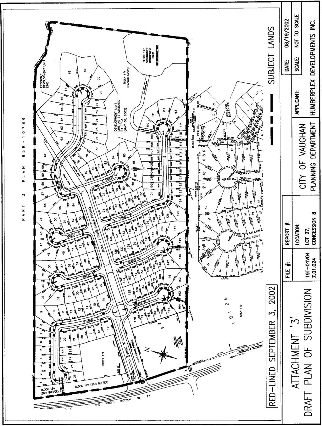
1 COMMITTEE OF THE WHOLE SEPTEMBER 3, 2002 ZONING BY-LAW AMENDMENT FILE Z DRAFT PLAN OF SUBDIVISION FILE 19T-01V04 HUMBERPLEX DEVELOPMENTS INC. REPORT #P Recommendation The Commissioner of Planning recommends: 1. THAT Draft Plan of Subdivision 19T-01V04 (Humberplex Developments Inc.), prepared by Brutto Consulting, dated May 30, 2002, BE DRAFT APPROVED, as red-lined September 3, 2002, subject to the conditions of draft approval contained within Attachment #1. 2. THAT Zoning By-law Amendment Application Z (Humberplex Developments Inc.) BE APPROVED, to rezone the lands to the appropriate zone categories and to provide exceptions to zoning standards, as required, to implement the approved draft plan of subdivision. 3. FOR the purposes of notice, the Subdivision Agreement shall contain a provision that parkland shall be dedicated, and/or cash-in-lieu paid, within the plan at the rates stipulated in OPA #601 and conform to the approved Cash-In-Lieu of Parkland Policy. 4. NOW THEREFORE BE AND IT IS HEREBY RESOLVED THAT the proposed Plan of Subdivision 19T-01V04 be allocated sewage capacity from the Kleinburg Water Pollution Control Plant and water capacity from the Kleinburg-Nashville Community Water System of the York Water Supply System, for a total of 170 residential units or an equivalent of 629 persons. Purpose On March 22, 2001, the Owner submitted an application to amend the Zoning By-law, together with a Draft Plan of Subdivision, to rezone the lands to R1 Residential Zone and OS1 Open Space Conservation Zone. The Draft Plan consists of 174 residential lots with frontages ranging from 18.28m to 37.14m, a stormwater management pond, and two park blocks. The Draft Plan has since been revised to propose 170 lots having frontages ranging from 14.36m to 29.48m, with a majority at 18.29m. The land use area breakdown of the subdivision is as follows: Land Uses Residential (170 detached lots) Park, Buffer, Walkways Valleyland Stormwater Management Pond Entrance Feature, Emergency Access TransCanada Pipeline Roads, Reserves, Servicing Easements TOTAL Area ha ha ha ha ha ha ha ha
2 Background - Analysis and Options The subject lands are located on the east side of Regional Road #27, south of Kirby Road in Part of Lot 27, Concession 8, City of Vaughan. The ha site, with m of frontage on Regional Road #27, is primarily used for farm fields and contains a dwelling and several farm buildings. The lands are designated Serviced Residential, Open Space, Valley Area and Neighbourhood Park by OPA #601 (Kleinburg-Nashville Community Plan). The zoning is A Agricultural Zone by By-law The surrounding land uses are as follows: North - golf course (OS2 Open Space Zone) South - linear park, water tower, residential (R1Residential Zone) East - valley land (OS1 Open Space Conservation Zone) West - Regional Road #27; residential, vacant commercial (RR Rural Residential Zone, C6 Highway Commercial Zone) At a Public Hearing on May 7, 2001, Council received the application and directed that any issues identified be addressed by Staff in a comprehensive report to the Committee of the Whole. A letter was received from the abutting golf course owner requesting a fence along the shared property line and cost-sharing. The ratepayers raised a number of concerns, including: size of the lots provision of a linear park width of the Highway #27 buffer view of the valley location of the park servicing capacity pedestrian access to Kleinburg core area architectural control Official Plan The lands are designated Serviced Residential, Valley Area, Open Space and Community Park by Official Plan Amendment #601 (Kleinburg-Nashville Community Plan). Amendment #601 permits a maximum density between 5.0 to 7.5 units per hectare for the Serviced Residential Area. Density is calculated on the basis of a net residential hectare, which includes local and primary roads, land for residential development, and environmental linkages located on tablelands. The total area for the proposed residential lots and the roads is hectares. At 170 units, the density for this development is 6.52 units/hectare, within the maximum range permitted in the Official Plan. The proposed development conforms to the Official Plan. Zoning The lands are currently zoned A Agricultural Zone by By-law The proposed zoning is R1 Residential Zone, which requires a minimum lot frontage of 18m and minimum lot area of 540 sq.m. Some of the proposed lots have frontages less than 18m due to their pie shape. Exceptions in the by-law will need to be provided for these lots. The park blocks will be zoned OS2 Open Space Park Zone, as will the buffer along Highway #27. The valley lands and stormwater management pond will be zoned OS1 Open Space Conservation Zone.
3 Subdivision Design The proposed plan of subdivision consists of 170 detached residential lots. The plan includes a stormwater management pond, valley lands, parks and a buffer along Highway #27. The development is based on a spine boulevard entering from Regional Road #27, from which 8 culde-sacs radiate. The park is located at the entrance to the subdivision and is adjacent to a 30m wide buffer along Highway #27. A number of walkways are provided to serve as pedestrian connections to the valley land, parks to the south, and access to the Kleinburg core. Amendment #601 requires a 30m to 50m wide landscape buffer along Highway #27 to screen the visibility of the residential development from the arterial roads. The proposal includes a 30m buffer along the Highway #27 frontage. The conditions of draft approval require the preparation of a landscape plan for the buffer block. Servicing On August 19, 2002, Council received an information item regarding the availability of increased servicing capacity for the Community of Kleinburg. A recommendation has been included in this report for Council to allocate servicing capacity to this development. A servicing report will be required to demonstrate how the proposed development is to be serviced. Roads Official Plan Amendment #601 notes that local roads shall generally have an 18.5 metre to 20 metre right-of-way. The Owner is proposing 17.5m right-of-way widths for the cul-de-sacs. Alternative Design Standards (ADS) for the road allowances would permit a right-of-way with a 17.5m width. Should Council wish to approve the use of ADS for this subdivision, the Engineering Department has no objections. Due to the proximity of the subject lands to Highway #27, a noise report is required for review and approval by the City. The City requires all dwelling units that abut or face an arterial road, to be constructed with mandatory air conditioning. All required acoustic barriers abutting public lands shall be constructed with all berming and fencing materials, including foundations, entirely on private lands. Parks The Urban Design Department has calculated the required parkland dedication to be ha. A total of ha of parkland has been provided in the plan, in the form a parkette (Block 17) along Regional Road #27 at the entrance to the subdivision. Cash-in-lieu of parkland will be required for the remaining.394 ha parkland. The Official Plan requires that a minimum buffer of 10m shall be established from the top-ofvalley bank, where development will not be permitted. The draft plan provides for a 5m public tableland buffer adjacent to the majority of the lots next to the valley corridor. In addition a rearyard of 7.5m will apply to all residential lots. The combined buffer and setback will effectively create a 12.5m structural setback from the valley edge. The policies in Amendment #601 regarding Views, Vistas and Focal Points are intended to preserve and enhance views to natural features including valley lands, topographic features and across open spaces and to provide for sites to terminate streets and view corridors wherever possible. The proposed development has provided a single pedestrian access to the valley and a public buffer along the top of the valley. Staff will examine the possibility of securing additional pedestrian access to the valley system from the easterly roads, where permitted by the topography.
4 All development in the Kleinburg residential areas is subject to the urban design policies of OPA #601. The Department of Urban Design recommends that Architectural Control Guidelines be prepared for this development and a condition has been included to this effect. TransCanada Pipeline The TransCanada Pipeline (TCPL) transects east/west across the subject lands. The draft plan shows the pipeline within a central boulevard of the primary spine road. TCPL objects to the approval of this draft plan in this format. Their reasons for objection include; number of crossings over the pipeline, safety issues related to third-party strikes, emergency response and operational issues. TCPL has recommended that the Owner apply to the National Energy Board for approval. The Owner has submitted a report from Ross Milne Consulting Ltd. in response to the concerns raised by TCPL. The report concludes that the pipeline easement is incorporated into the subdivision in a way that protects the safety of the subdivision residents. The design of the plan allows TransCanada Pipelines Limited to monitor and maintain the pipeline, as well as carry out major repairs and replacement. If all applicable Codes and National Energy Board requirements are met, and the required Pipeline Crossing Agreements are fully executed to the satisfaction of the City, the Engineering Department has no concerns with these issues, from the City s perspective. The consultant s report recommends several conditions that are required to comply with National Energy Board regulations, including the necessary crossing agreements, which have been included in the conditions of draft approval. Heritage The dwelling on the property has been identified as a heritage dwelling (Train Log House). The Kleinburg and Area Ratepayers Association are opposed to the demolition of this house. Heritage Vaughan passed the following resolution at its meeting of March 20, 2002: THAT Heritage Vaughan recommends the preservation of the Train Log House located at Highway #27; and, THAT the owner contact Culture staff to discuss the preservation of the structure; and, THAT the structure be boarded up in order to secure the building as per the City s Bylaw. A draft condition has been included in Attachment #1 that requires the preservation and relocation of the Train Log House by the Owner. Other Comments The Region of York has indicated no objections to the approval of this plan, subject to conditions of draft approval, incorporated into Attachment #1. The Toronto and Region Conservation Authority has indicated no objection to this development, subject to conditions of approval that have been incorporated into Attachment #1. The School Boards have advised that they do not require school sites within this proposed plan of subdivision.
5 Conclusion Staff have reviewed the applications for rezoning and draft plan of subdivision consisting of a total of 170 residential lots, buffer block, park and valleyland, and are of the opinion that the proposal conforms to the Official Plan. The zoning of the lands will be compatible with the zoning in the immediate area and would implement the designation of the site. Additionally, the OS1 Open Space Conservation Zone on the valleylands and the 5m public tableland buffer, would restrict development on these lands. Staff can support approval of the zoning amendment application and draft plan of subdivision, subject to the red-line plan and the conditions of draft approval contained within Attachment #1. Should Council concur, the Recommendation of this report can be adopted. Attachments 1. Draft Conditions 2. Location Map 3. Draft Plan of Subdivision 4. Report from Ross Milne Consulting Ltd. (FOR COUNCILLORS ONLY) 5. Letter from TransCanada Pipeline Limited (FOR COUNCILLORS ONLY) Report prepared by: Marco Ramunno, Manager, Development Planning, ext Respectfully submitted, MICHAEL DeANGELIS Commissioner of Planning JOANNE R. ARBOUR Director of Community Planning /CM R:\ser\working\colest\Humberplex.cw.doc
6 ATTACHMENT NO. 1 CONDITIONS OF DRAFT APPROVAL DRAFT PLAN OF SUBDIVISION 19T-01V04 HUMBERPLEX DEVELOPMENTS INC. LOT 27, CONCESSION 8, CITY OF VAUGHAN THE CONDITIONS OF THE COUNCIL OF THE CITY OF VAUGHAN THAT SHALL BE SATISFIED PRIOR TO THE RELEASE FOR REGISTRATION OF PLAN OF SUBDIVISION 19T-01V04, ARE AS FOLLOWS: City of Vaughan Conditions 1. The Plan shall relate to the draft plan of subdivision, prepared by Brutto Consulting, drawing #00-350, dated April, 2002 (revised May 30, 2002), as red-lined on September 3, 2002 to incorporate the following revisions: a) provide a 23m feeder road right-of-way for Street A and include a "feeder road to arterial road intersection design" at its intersection with Highway No. 27, as per City Standard Drawings B-5 and D-4; also, provide a 6m wide minimum pavement section for Street A along each side of the center medium to facilitate fire route requirements. b) provide daylight triangles and associated 0.3m reserves at all intersections of Street A, with Streets B, C, D, E, F, G, H, and I, as per City Standard Drawing D-1. c) confirm a 90 degree centre-line match at the intersection of Street A, with Streets B, C, D, E, F, G, H, and I, and Highway No.27. d) confirm angle bends for Streets C, H, and I, as per City Standard Drawing C-3. e) confirm a minimum 65m centre-line radius for Streets C, D, F and I, as per City Standard Drawing C-4. f) provide additional sidewalk locations in accordance to the City of Vaughan Sidewalk Policy, to be detailed on the construction drawings. g) any revisions as required by the Engineering Department Transportation Division. h) provide additional walkway block(s) connecting to the valleyland, to the satisfaction of the City. 2. The lands within this Plan shall be appropriately zoned by a zoning by-law, which has come into effect in accordance with the provisions of The Planning Act, including: a) all residential lots placed in the R1 Residential Zone, with exceptions provided for lots not meeting the minimum 18m frontage. b) Blocks 174 and 177 placed in an appropriate Open Space Zone to prohibit structural encroachment. 1
7 c) a minimum 7.5m structural setback abutting the open space for Lots 64 to 85 inclusive, and Lots 108 to 114 inclusive. d) a minimum 10m setback from the TransCanada Pipeline right-of-way for all structures and excavations. 3. The Owner shall pay any and all outstanding application fees to the Community Planning Department, in accordance with Tariff of Fees By-law The Owner shall enter into a subdivision agreement with the City to satisfy all financial and other conditions, with regard to such matters as the City may consider necessary, including payment of development levies and the woodlot development charge, the provision of roads and municipal services, landscaping and fencing. The said agreement shall be registered against the lands to which it applies. 5. The Owner shall agree to create easements for maintenance purposes for all lots providing less than 1.2 m sideyards, or having roof encroachments, prior to transfer of land. 6. Prior to final approval, easements required for utility, drainage and construction purposes shall be created and granted to the appropriate authority(ies), free of all charge and encumbrances. 7. The road allowances within this Plan shall be named to the satisfaction of the City, in consultation with the Regional Planning Department; proposed street names shall be submitted by the Owner for approval by Council and shall be included on the first engineering drawings. 8. The road allowances within the Plan shall be designed in accordance with the City s engineering standards and shall be dedicated to the City free of all charge and encumbrances. The streets, lots and blocks shall be designed to coincide with the development pattern on adjacent properties. 9. Any dead end or open side of a road allowance within the Plan shall be terminated in a 0.3m reserve, to be conveyed to the City free of all charge and encumbrances, until required for a future road allowance or development of adjacent lands. 10. Final engineering design(s) may result in minor variations to the Plan (eg., in the configuration of road allowances and lotting, number of lots etc.), which may be reflected in the final plan to the satisfaction of the City. 11. The Owner shall agree that construction access shall be provided only in a location approved by the City and/or the appropriate authority. 12. Prior to final approval, the Owner shall submit a soils report, and the Owner shall agree to implement the recommendations of such report, as approved by the City. 13. The Owner shall agree to remove any driveways and buildings on site, which are not approved to be maintained as part of the plan or for construction purposes; any modification to off-site driveways required to accommodate this Plan shall be co-ordinated and completed at the cost of the Owner. 14. The Owner shall agree that all lots or blocks to be left vacant shall be graded, seeded, maintained and signed to prohibit dumping and trespassing. 2
8 15. The Owner shall agree that no building permits will be applied for until the City is satisfied that adequate access, municipal water, sanitary and storm services are available. 16. The Owner shall agree in the subdivision agreement to carry out improvements and/or upgrades to the existing sanitary sewer system in Kleinburg including the wastewater pumping station at Nashville Road and Regional Road #27 that may be necessary to provide an sanitary outlet to the Plan to the satisfaction of the City. 17. Prior to the transfer of pertinent lots within the Plan, the Owner shall construct a 1.5 metre high black vinyl chain link fence along the limits of the residential lots where they abut the open space, storm water management, and/or park blocks to the satisfaction of the City. 18. Warning clauses shall be included in all Offers of Purchase and Sale or Lease with respect to the TransCanada Pipeline, to the satisfaction of the City. 19. The Owner shall agree that on lots with flankages on a collector or primary road, as identified by the Architectural Design Guidelines and the City, a front elevation featuring a main entrance or in some cases, an upgraded elevation, shall face the flankage. The flankage elevation for such lots shall be approved by the Control Architect, and the Director of Urban Design and/or the Director of Community Planning, prior to issuance of a building permit. 20. a) Prior to the initiation of grading or stripping of topsoil and prior to final approval, the Owner shall submit environmental site assessment report(s) in accordance with the "Ministry of Environment and Energy s Guidelines for Use at Contaminated Sites in Ontario, June 1996", as amended, and shall reimburse the City for the cost of peer review of the reports. b) Should site remediation be required to meet the applicable soil and ground water criteria set out in the above Guidelines, the Owner shall submit to the City prior to final approval, a copy of the Record of Site Condition acknowledged by a Provincial Officer of the Ministry of the Environment. c) The Owner shall provide a certificate by a qualified professional that all lands within the Plan and any lands and easements external to the Plan to be dedicated to the City, meet the applicable soil and ground water criteria noted above. d) Where lands are being conveyed to the municipality for parkland purposes, the Owner shall agree that prior to issuance of any building permits, the Owner shall submit a Phase 2 environmental site assessment report(s) addressing all park blocks in the plan, in accordance with the Ministry of Environment Guideline for Use at Contaminated Sites in Ontario (June 1996 as amended), to the satisfaction of the City. On-site sampling contained in the reports shall be conducted following completion and certification of the rough grading of the park block(s). Testing may include but not be limited to surface and subsurface soil, ground water, soil vapor, plant and aquatic species sampling and testing of building materials. The Owner shall reimburse the City for the cost of peer review of said report(s). 3
9 e) The Owner shall incorporate the recommendations contained in the report from paragraph (d) and ensure adequate field inspection is provided to validate the recommendation in the Phase II E.S.A. to the satisfaction of the City. 21. a) Prior to final approval and prior to any works commencing on the site, the Owner shall submit for approval by the City and the Toronto and Region Conservation Authority (TRCA), a detailed engineering report(s) that describes the storm drainage system (quantity and quality) for the proposed development, and how it will comply with the approved Wycliffe-Humberplex Master Environmental Servicing Plan (URS Cole Sherman, March 2001, Addendum Report July 2001, and all additional submissions and correspondance), which shall include: i) plans illustrating how this drainage system will be tied into the surrounding drainage systems, and indicating whether it is part of an overall drainage scheme, the design capacity of the receiving system and how external flows will be accommodated; ii) iii) iv) the location and description of all outlets and other facilities; stormwater management techniques which may be required to control minor and major flows; proposed methods of controlling or minimizing erosion and siltation on-site and in downstream areas during and after construction; v) overall grading plans for the subject lands; and vi) storm water management practices to be used to treat stormwater, to mitigate the impacts of development on the quality and quantity of ground and surface water resources as it relates to fish and their habitat. b) The Owner shall agree to implement the recommendations set out in the aforementioned report(s) to the satisfaction of the City and TRCA. 22. The Owner shall agree: a) to obtain all necessary permits pursuant to Ontario Regulation 158 and the Lakes and Rivers Improvement Act. b) to maintain all stormwater management and erosion and sedimentation control structures operating and in good repair during the construction period. c) to erect a permanent fence to the satisfaction of the TRCA for lots and blocks abutting Block 174. d) to obtain authorization under the Federal Fisheries Act through the submission of a comprehensive fish habitat compensation package for the harmful alteration, disruption or destruction of fish habitat, where deemed applicable. 4
10 e) to provide a copy of the executed subdivision agreement to The Toronto and Region Conservation Authority. f) that in conjunction with Condition #22 and paragraphs (a), (b) and (c) above, the Owner shall prepare a comprehensive Open Space Master Plan for Blocks 174 and 177 which shall implement the restoration/enhancement plan in accordance with the approved MESP and supporting documentation. 23. Prior to final approval, the Owner shall pay the proportionate share of the cost of any external municipal services, including local improvement projects that have been designed and oversized by others to accommodate the subject plan, to the satisfaction of the City. 24. a) Prior to final approval, the Owner shall satisfy all technical, financial and other requirements of Hydro Vaughan Distribution Inc., its successors and assigns, (herein Hydro Vaughan) regarding the design, installation, connection and/or expansion of electric distribution services, or any other related matters; the Owner shall enter into a development agreement with Hydro Vaughan which addresses the foregoing requirements. b) The Owner shall agree to design, purchase materials, and install a buried hydro distribution system, compatible with the existing and/or proposed systems in surrounding Plans, all in accordance with the latest standards and specifications of Hydro Vaughan Distribution Inc and the City. 25. Prior to final approval, the Owner shall submit a noise and/or vibration study, prepared by a qualified consultant for approval by both the City and the Region of York. The preparation of the noise report shall include the ultimate traffic volumes associated with the surrounding road network. The Owner shall agree in the subdivision agreement to implement the approved abatement measures. 26. The Owner shall convey the following lands to the City or the TRCA, where appropriate, free of all charge and encumbrances: a) Block 177 for stormwater management purposes b) Block 174 for open space purposes c) Blocks 172, 181 and 184 for landscaping purposes d) Block 171 for parkland purposes 27. The Owner shall agree to design, purchase materials and install a street lighting system, compatible with the existing and/or proposed systems in surrounding plans, all in accordance with City standards and specifications. 28. The Owner shall agree to erect fencing in the locations and of the types as shown on the approved construction drawing and as required by the City, in accordance with an Urban Design and Architectural Design Guidelines. 29. The Owner shall agree to pay the City at the time of registration of the Plan, payment at the rate of $1, per residential unit, plus $ per future unit on each part lot, as per Schedule "I", in accordance with the Special Area Woodlot Development Charge By-law. 5
11 30. Prior to final approval, the Owner shall submit a tree assessment, including an inventory of all existing trees, assessment of significant trees to be preserved, and proposed methods of tree preservation/or remedial planting; the Owner shall not remove trees without written approval of the City and shall agree to undertake the measures identified in the City-approved assessment. 31. Prior to final approval, the Owner shall submit: a) an urban design/streetscape master plan in accordance with the policies outlines in the Kleinburg-Nashville Community Plan for OPA #601, which shall address, at minimum, the following: internal landscaping on boulevards as it relates to the road rights-of-ways and the location of underground services (ie. typical road sections incorporating boulevard trees); co-ordination of the urban design/streetscape elements as they relate to the Kleinburg-Nashville Community Plan, including entrance features and medians; landscaping of buffer Blocks 172 and 184 along Highway #27. the appropriate continuous pedestrian linkage between the park and valley through the TransCanada Pipeline Block 173. the appropriate configuration and landscape treatment of the stormwater management pond Block Prior to final approval, the Owner shall not remove any vegetation or topsoil or start any grading of the lands, without a fill permit issued by the City, and a development agreement, if necessary. 33. Prior to final approval, the Owner shall prepare a detailed open space master plan for review and approval by the City and TRCA. The master plan shall address, but not limited to, edge management rehabilitation planting, trails, bridge crossings, erosion repair sites and pedestrian access points into the valley. For Blocks 174 and 177, the master plan shall implement the restoration/enhancement plan in accordance with the approved MESP and supporting documentation. 34. Prior to final approval, architectural guidelines shall be submitted for Council s approval; the Owner shall agree that: a) all development shall proceed in accordance with the Council approved architectural design guidelines. b) a control architect satisfactory to the City shall be retained at the cost of the Owner, to ensure that all development proceeds in compliance with the approved architectural design guidelines. c) prior to the submission of individual building permit applications, the control architect shall have stamped and signed the drawings certifying compliance with the approved architectural guidelines. 6
12 d) City may undertake periodic reviews to ensure compliance with the architectural guidelines; should inadequate enforcement be evident, the City may cease to accept drawings stamped by the control architect and retain another control architect at the expense of the Owner. 35. In the event that the Owner and the City agree that the Owner will develop Park Block 171, the Owner shall agree that the design, securities and construction for the park will be addressed through an amending agreement in accordance with the City Developer Build/Parks Development Policy. 36. a) Prior to final approval and prior to commencement of any works on any site identified as being archaeologically significant, the Owner shall carry out archaeological excavations of such sites to the satisfaction of the Ministry of Citizenship, Culture and Recreation (Archeological Unit) and the City; the Owner shall agree to take protective measures required by the City for such sites. b) Prior to the commencement of any archaeological field work, a copy of the contract information sheet which was submitted to the Ontario Heritage Foundation, shall have been forwarded to the City; licensed consultants are urged to review the Archaeological Facility Master Plan Study housed in the City of Vaughan Archives, prior to commencing any fieldwork. 37. Prior to final registration the Owner shall ensure the preservation and relocation of the Train Log House located on the property, to the satisfaction of the Heritage Vaughan Committee. 38. The Owner agrees to: a) include on all offers of purchase and sale, a statement which advises the prospective purchaser that mail delivery will be from a designated Community Mailbox. b) be responsible for notifying the purchaser of the exact Community mailbox locations prior top the closing of any home sale. c) consult with Canada Post Corporation to determine suitable locations for placement of Community Mailboxes and to indicate these locations on the appropriate servicing plans. d) determine and provide suitable temporary Community Mailbox location(s), which may be utilized by Canada Post until curbs, sidewalks and final grading have been completed at the permanent Community Mailbox locations. 39. The Owner agrees to: a) provide the following for each community mailbox site, as shown on the servicing plans: i) a sidewalk section (concrete pad), as per municipal and Canada Post standards, to support the mailboxes; ii) iii) any required walkway across the boulevard, as per municipal standards; and, any required curb depressions. 7
13 b) provide a suitable temporary community mailbox location(s) until the curbs, sidewalks and final grading have been completed at the permanent location(s). c) provide a copy of the executed agreement to Canada Post. 40. The Owner shall cause the following warning clauses to be included in a schedule to all offers of purchase and sale, or lease for all lots/blocks: a) within the entire subdivision plan: "Purchasers and/or tenants are advised that despite the inclusion of noise control features within both the development area and the individual building units, noise levels, including from construction activities, may be of concern and occasionally interfere with some activities of the dwelling occupants." "Purchasers and/or tenants are advised that the proposed finished lot and/or block grading may not meet City of Vaughan lot grading criteria in certain areas, to facilitate preservation of existing vegetation and to maintain existing adjacent topographical conditions." "Purchasers and/or tenants are advised that traffic calming measures may have been incorporated into the road allowances." "Purchasers and/or tenants are advised that the planting of trees on City boulevards in front of residential units is a requirement of the City and a conceptual location Plan is included in the subdivision agreement. While every attempt will be made to plant trees as shown, the City reserves the right to relocate or delete any boulevard tree without further notice. Purchasers and/or tenants are advised that the City has not imposed a "tree fee", or any other fee which may be charged as a condition of purchase, for the planting of trees. Any "tree fee" paid by a purchaser for boulevard trees does not guarantee that a tree will be planted on the boulevard adjacent to their residential dwelling." "Purchasers and/or tenants are advised that where Canadian National or Canadian- Pacific railway company(s), or its assigns or successors in interest, has a right-ofway within 300 metres from the subject lands, and there may be future alterations or expansions to the rail facilities or operations which may affect the living environment of the residents in the vicinity, notwithstanding any noise and vibration attenuating measures included in the development and individual dwelling(s); CNR/CPR will not be responsible for any complaints or claims arising from use of such facilities and/or operations on, over or under the aforesaid right-of-way." "Purchasers and/or tenants are advised that mail delivery will be from a designated community mailbox, the location of which will be identified by the Owner prior to any home closings." 8
14 "Purchasers and/or tenants are advised that any roads ending in a dead end or culde-sac may be extended in the future to facilitate development of adjacent lands, without further notice." b) abutting any open space, woodlot or stormwater facility: "Purchasers and/or tenants are advised that the adjacent open space, woodlot or stormwater management facility may be left in a naturally vegetated condition and receive minimal maintenance." c) abutting a park block: "Purchasers and/or tenants are advised that the lot abuts a "Neighbourhood Park", and that noise and lighting should be expected from the designed active use of the park." 41. The Owner shall cause the following to be displayed on the interior wall of the sales office, information approved by the City of Vaughan, prior to offering any units for sale, to be monitored periodically by the City. No building permit shall be issued for a sales office or model home, or a residential unit until such information is approved by the City of Vaughan. the land use for the broader area, showing surrounding land uses, arterials/highways, railways and hydro lines etc. the location of street utilities, community mailboxes, entrance features, fencing and noise attenuation features, together with the sidewalk plan approved in conjunction with draft plan approval. the location of parks, open space, stormwater management facilities and trails. the location of institutional uses, including schools, places of worship, community facilities. the location and type of commercial sites. colour-coded residential for singles, semis, multiples, and apartment units. the following notes in BOLD CAPITAL TYPE on the map: "For further information, on proposed and existing land uses, please call or visit the City of Vaughan Community Planning Department, at 2141 Major Mackenzie Drive, (905) " "For detailed grading and berming information, please call the developer s engineering consultant, (name) at ". "This map is based on information available as of (date of map), and may be revised or updated without notification to purchasers." 9
15 [In such circumstances, the Owner is responsible for updating the map and forwarding it to the City for verification.] 42. Where the Owner proposes to proceed with the construction of a model home(s) prior to registration of the Plan, the Owner shall enter into an agreement with the City, setting out the conditions, and shall fulfill relevant conditions of that agreement prior to issuance of a building permit. 43. Prior to the initiation of grading or stripping of topsoil and prior to final approval, the Owner shall submit a topsoil storage plan detailing the location, size, side slopes, stabilization methods and time period, for approval by the City. Topsoil storage shall be limited to the amount required for final grading, with the excess removed from the site, and shall not occur on either park or school blocks. 44. Prior to final registration, the Owner shall: a) submit an application to TransCanada Pipelines (TCPL) for approval to cross their pipeline and sign a Crossing Agreement that is in compliance with current National Energy Board regulations. b) design and install the permanent fencing along TCPL s easement in a manner that will allow TCPL access through gates or other means to carry out their normal monitoring and maintenance programs. 45. The Owner shall agree a) to provide TCPL s Regional Office five business days advance notice in writing before commencing construction activities on the site. b) that the Owner, or their contractors shall not undertake any construction activity involving grading of the TCPL easement or excavation with power equipment within 30m of the easement without TCPL s prior approval and without giving TCPL s Regional Office 3 business days written notice. b) that the Owner, or their contractors, shall not carry out any excavation using power equipment within 0.5m of the pipeline. 46. Prior to final approval, the City shall be advised by the School Board(s) that satisfactory arrangements regarding the adequate provision and distribution of educational facilities have been made between the Owner and the School Board(s). Region of York Conditions 47. The following lands shall be conveyed to the Region of York for public highway purposes, free of all costs and encumbrances, as shown on the red-lined draft plan: a) 15m by 15m daylighting triangles at the intersection of Street A and Highway No The intersection of Street A and Highway No. 27 shall be designed and constructed to the satisfaction of the Regional Transportation and Works Department with any interim or permanent 10
16 intersection work including turning lanes, profile adjustments, illumination and/or signalization as deemed necessary by the Regional Transportation and Works Department. 49. The Owner shall provide a set of engineering drawings for approval by the Region which indicates the subdivision storm drainage system, site grading and servicing, plan and profile for proposed intersections, construction access and mud mat design, utility location plans, pavement markings, intersection signalization and illumination design, traffic control/construction staging plans, and landscape plans. 50. The Owner shall agree: a) that any noise attenuation required fences adjacent to Regional roads shall be constructed only on the private side of the 0.3 metre reserve, to a maximum of 2.5 metres in height, subject to the area municipality s concurrence. b) that maintenance of the noise barriers and fences bordering on Regional right-of-ways shall not be the responsibility of the Region. c) that any landscaping provided on the Regional right-of-way by the Owner or the area municipality, must be approved by the Region and maintained by the area municipality, with the exception of the usual grass maintenance. 51. The Owner shall provide the following to the Region of York: a) a copy of the executed subdivision agreement; and b) a Solicitor s Certificate of Title to the Region of York Corporate and Legal Services Department, to the satisfaction of the Regional Solicitor, at no cost to the Region, with respect to the conveyance of lands to The Regional Municipality of York. 52. The Owner shall provide sidewalks connecting to Highway No. 27 to access future transit service to the satisfaction of the Region of York. 53. The Region shall confirm that adequate water supply capacity and sewage treatment capacity are available for the development proposed within this draft plan of subdivision or any phase thereof and have been allocated thereto by the City of Vaughan. 54. The Region shall confirm that the required water supply and sanitary sewage contracts have been let to accommodate the development proposed within this draft plan of subdivision or any phase thereof. 55. The Owner shall enter into an agreement with the Region of York, agreeing to satisfy all conditions, financial and otherwise, of the Regional Corporation; Regional Development Charges are payable prior to final approval in accordance with By-law DC Other Conditions 56. Final approval for registration may be issued in phases to the satisfaction of the City, subject to all applicable fees provided that: 11
17 a) phasing is proposed in an orderly progression, in consideration of such matters as the timing of road improvements, infrastructure, schools and other essential services; and b) all government agencies agree to registration by phases and provide clearances, as required in Conditions 1 to 55 inclusive, for each phase proposed for registration; furthermore, the required clearances may relate to lands not located within the phase sought to be registered. 57. The City shall advise that Conditions 1 to 46 inclusive, have been satisfied; the clearance letter shall include a brief statement detailing how each condition has been met. 58. The Regional York shall advise that Conditions 47 to 55 inclusive, have been satisfied; the clearance letter shall include a brief statement detailing how each condition has been met. 12
18
19
COMMITTEE OF THE WHOLE JUNE 17, 2002 ZONING BY-LAW AMENDMENT FILE Z DRAFT PLAN OF SUBDIVISION FILE 19T-01V08 MAJORWEST DEVELOPMENT CORPORATION
 COMMITTEE OF THE WHOLE JUNE 17, 2002 ZONING BY-LAW AMENDMENT FILE Z.01.050 DRAFT PLAN OF SUBDIVISION FILE 19T-01V08 MAJORWEST DEVELOPMENT CORPORATION Recommendation The Commissioner of Planning recommends:
1. That the Block 18 Phasing Plan (Attachment #4) BE APPROVED.
 BE APPROVED.") COMMITTEE OF THE WHOLE JUNE 21, 2004 ZONING BY-LAW AMENDMENT FILE Z.02.084 DRAFT PLAN OF SUBDIVISION FILE 19T-02V10 1275620 ONTARIO INC. REPORT P.2004.15 Recommendation 1. That the Block 18 Phasing Plan
COMMITTEE OF THE WHOLE JUNE 21, 2004 ZONING BY-LAW AMENDMENT FILE Z.02.084 DRAFT PLAN OF SUBDIVISION FILE 19T-02V10 1275620 ONTARIO INC. REPORT P.2004.15 Recommendation 1. That the Block 18 Phasing Plan
5. That the Owner shall agree that all development Blocks shown within the Draft Plan will be connected to full municipal services.
 Conditions Relating to Draft Plan of Subdivision Approval East Fonthill 26T 01014 (Draft Plan dated December 1, 2013, and revised August 28, 2014), the Town of Pelham 1. This approval applies to the Draft
The Corporation of The Town of Richmond Hill. Schedule of Conditions. Draft Plan of Subdivision. File 19T(R)-16002
-16002") Town of Richmond Hill The Corporation of The Town of Richmond Hill Development Planning Division Schedule of Conditions Draft Plan of Subdivision File 19T(R)-16002 Country Wide Homes (Jefferson) Inc. Lots
Town of Richmond Hill The Corporation of The Town of Richmond Hill Development Planning Division Schedule of Conditions Draft Plan of Subdivision File 19T(R)-16002 Country Wide Homes (Jefferson) Inc. Lots
The Corporation of The Town of Richmond Hill. Schedule of Conditions. Draft Plan of Subdivision. File 19T(R) Town of Richmond Hill
 Town of Richmond Hill") The Corporation of The Town of Richmond Hill Development Planning Division Schedule of Conditions Draft Plan of Subdivision File 19T(R)-14009 Country Wide Homes (Jefferson) Inc. Lot 3, Plan 65M-2071 Town
The Corporation of The Town of Richmond Hill Development Planning Division Schedule of Conditions Draft Plan of Subdivision File 19T(R)-14009 Country Wide Homes (Jefferson) Inc. Lot 3, Plan 65M-2071 Town
Chair and Members Planning and Economic Development Committee
 TO: FROM: Chair and Members Planning and Economic Development Committee Melissa Halford Manager of Planning DATE: June 23, 2016 SUBJECT: Amendment No. 6 to Draft Approval Subdivision File No. S2006-3 (Loon
TOWN OF WHITBY REPORT RECOMMENDATION REPORT
 TOWN OF WHITBY REPORT RECOMMENDATION REPORT REPORT TO: Planning and Development Committee REPORT NO: PL 4-08 DATE OF MEETING: January 21, 2008 FILE NO(S): MI-01-07 (SW- 2002-03) PREPARED BY: Planning Department
MIDHURST DRAFT PLAN OF SUBDIVISION CONDITIONS OF APPROVAL SP-T-1005: D. Hickling August 29, 2014August 2, 2017
 No. Conditions DRAFT PLAN 1. This approval applies to the proposed draft plan of subdivision located at PT E1/2 LT 15 CON 6 Vespra, PT E1/2 LT 14 CON 6 Vespra, as in RO1472251; S/T RO147294; S/T easement
and Members of Municipal Council
 REPORT TO: SUBMITTED BY: SUBJECT: Mayor James M. Diodati and Members of Municipal Council Planning, Building & Development 26T-11-2017-002 Winzen Niagara Draft Plan of Subdivision 4825 Pettit Avenue Applicant:
MIDHURST DRAFT PLAN OF SUBDIVISION CONDITIONS OF APPROVAL SP-T-1004: Micks August 29, 2014August 2, 2017
 No. Conditions DRAFT PLAN 1. This approval applies to the proposed draft plan of subdivision located at PT W1/2 LT 14 CON 6 Vespra as in RO1442683 except PT 3 51R38091 subject to an easement as in RO144798;
Guidelines for the Approval of New Homes Sales Offices (Building Permits, Agreements, Securities)
") Guidelines for the Approval of New Homes Sales Offices (Building Permits, Agreements, Securities) ENCLOSURES: Site Plan Application Building Permit Application Grading and Drainage Approval Requirements
Guidelines for the Approval of New Homes Sales Offices (Building Permits, Agreements, Securities) ENCLOSURES: Site Plan Application Building Permit Application Grading and Drainage Approval Requirements
CONDITIONS OF DRAFT PLAN OF SUBDIVISION APPROVAL
 CONDITIONS OF DRAFT PLAN OF SUBDIVISION APPROVAL CONDITIONS OF DRAFT APPROVAL FOR PLAN OF SUBDIVISION 24T-08001/H Part of Park Lot 3 and Ann Street, Cavanaugh s Unregistered Plan, Part of the East Half
CITY OF VAUGHAN POLICY AND PROCEDURES FOR DEALING WITH CONTAMINATED OR POTENTIALLY CONTAMINATED SITES
 CITY OF VAUGHAN POLICY AND PROCEDURES FOR DEALING WITH CONTAMINATED OR POTENTIALLY CONTAMINATED SITES MAY 2001 This Report should be read in conjunction with the City of Vaughan BACKGROUND REPORT ON POLICY
Staff Report for Committee of the Whole Meeting
 Agenda Item 22 Staff Report for Committee of the Whole Meeting Department: Division: Subject: Planning and Regulatory Services Development Planning Request for Approval Zoning Amendment and Draft Plan
TOTTENHAM SECONDARY PLAN
 TOTTENHAM SECONDARY PLAN AMENDMENT NO. 11 TO THE OFFICIAL PLAN OF THE TOWN OF NEW TECUMSETH The following text and schedules to the Official Plan of the Town of New Tecumseth constitute Amendment No. 11
Corporate Report. Planning & Development Services, Implementation. Date of Report: January 7, 2013 Date of Meeting: January 21, 2013
 Corporate Report Report from Planning & Development Services, Implementation Date of Report: January 7, 2013 Date of Meeting: January 21, 2013 Report Number: PDS-019-2013 File: 60.46.394 Subject: Application
OFFICE CONSOLIDATION
 OFFICE CONSOLIDATION SECONDARY PLAN AREA 2A THE NORTHWEST SANDALWOOD PARKWAY SECONDARY PLAN February 2010 EXPLANATORY NOTES (Secondary Plan Area 2(a)) General (pertaining to all secondary plan office consolidations)
Committee of Adjustment Agenda
 Committee of Adjustment Agenda Hearing Date: May 25, 2017 Time: 7:00 p.m. Location: 225 East Beaver Creek Road, 1 st Floor (Council Chambers) Call to Order Disclosure of Pecuniary Interest Requests for
Committee of the Whole (Public Hearing) Report
 Report") Item: 6 Committee of the Whole (Public Hearing) Report DATE: Tuesday, January 22, 2019 WARD: 1 TITLE: CAL-CROWN HOMES (THREE) INC. ZONING BY-LAW AMENDMENT FILE Z.18.016 DRAFT PLAN OF SUBDIVISION FILE 19T-18V007
Item: 6 Committee of the Whole (Public Hearing) Report DATE: Tuesday, January 22, 2019 WARD: 1 TITLE: CAL-CROWN HOMES (THREE) INC. ZONING BY-LAW AMENDMENT FILE Z.18.016 DRAFT PLAN OF SUBDIVISION FILE 19T-18V007
COMMITTEE OF THE WHOLE MEETING APRIL 23, 2018
 REPORT #PD-2018-12 COMMITTEE OF THE WHOLE MEETING APRIL 23, 2018 DRAFT PLAN EXTENSION REQUEST WALTON DEVELOPMENT AND MANAGEMENT WALTON INDUSTRIAL PLAN OF SUBDIVISION 7005 INDUSTRIAL PARKWAY SETTLEMENT
CITY OF VAUGHAN EXTRACT FROM COUNCIL MEETING MINUTES OF MAY 16, 2017
 CITY OF VAUGHAN EXTRACT FROM COUNCIL MEETING MINUTES OF MAY 16, 2017 Item 1, Report No. 18, of the Committee of the Whole (Public Hearing), which was adopted without amendment by the Council of the City
Committee of Adjustment Agenda
 Committee of Adjustment Agenda Hearing Date: July 6, 2017 Time: 7:00 p.m. Location: 225 East Beaver Creek Road, 1 st Floor (Council Chambers) Staff reports obtained online do not include hard copy information
CITY OF VAUGHAN EXTRACT FROM COUNCIL MEETING MINUTES OF MAY 7, 2007
 Item 1, Report No. 24, of the Committee of the Whole (Public Hearing), which was adopted without amendment by the Council of the City of Vaughan on May 7, 2007. 1 ZONING BY-LAW AMENDMENT FILE Z.06.071
CITY OF VAUGHAN EXTRACT FROM COUNCIL MEETING MINUTES OF DECEMBER 9, 2014
 CITY OF VAUGHAN EXTRACT FROM COUNCIL MEETING MINUTES OF DECEMBER 9, 2014 Item 22, Report No. 41, of the Committee of the Whole, which was adopted without amendment by the Council of the City of Vaughan
CITY OF VAUGHAN EXTRACT FROM COUNCIL MEETING MINUTES OF SEPTEMBER 27, 2018
 CITY OF VAUGHAN EXTRACT FROM COUNCIL MEETING MINUTES OF SEPTEMBER 27, 2018 Item 5, Report No. 28 of the Committee of the Whole (Public Hearing), which was adopted without amendment by the Council of the
COUNTY OF BRANT DEVELOPMENT SERVICES DEPARTMENT COMMITTEE OF ADJUSTMENT. Chair and Members of the Committee of Adjustment
 COUNTY OF BRANT DEVELOPMENT SERVICES DEPARTMENT COMMITTEE OF ADJUSTMENT TO: FROM: Chair and Members of the Committee of Adjustment Ruchika Angrish, Senior Planner DATE: January 23, 2014 REPORT: CA-14-06
CITY OF VAUGHAN EXTRACT FROM COUNCIL MEETING MINUTES OF MAY 5, 2009
 Item 1, Report No. 25, of the Committee of the Whole (Public Hearing), which was adopted without amendment by the Council of the City of Vaughan on May 5, 2009. 1 ZONING BY-LAW AMENDMENT FILE Z.06.027
EXCERPTS FROM HALIFAX REGIONAL MUNICIPALITY CHARTER
 EXCERPTS FROM HALIFAX REGIONAL MUNICIPALITY CHARTER Municipal planning strategy 227 The Council may adopt a municipal planning strategy for all, or part, of the Municipality and there may be separate strategies
3035 Weston Road - Official Plan and Zoning By-law Amendment and Draft Plan of Subdivision Applications - Request for Directions Report
 STAFF REPORT ACTION REQUIRED 3035 Weston Road - Official Plan and Zoning By-law Amendment and Draft Plan of Subdivision Applications - Request for Directions Report Date: December 18, 2007 To: From: Wards:
CITY OF VAUGHAN EXTRACT FROM COUNCIL MEETING MINUTES OF FEBRUARY 21, 2017
 CITY OF VAUGHAN EXTRACT FROM COUNCIL MEETING MINUTES OF FEBRUARY 21, 2017 Item 1, Report No. 7, of the Committee of the Whole (Public Hearing), which was adopted, as amended, by the Council of the City
CITY OF VAUGHAN EXTRACT FROM COUNCIL MEETING MINUTES OF JUNE 19, 2018
 CITY OF VAUGHAN EXTRACT FROM COUNCIL MEETING MINUTES OF JUNE 19, 2018 Item 39, Report No. 21, of the Committee of the Whole, which was adopted, as amended, by the Council of the City of Vaughan on June
APPENDIX "39T "
 14 APPENDIX "39T-00513-1" (Conditions to be included for Draft Plan Approval) THE CORPORATION OF THE CITY OF LONDON'S CONDITIONS AND AMENDMENTS TO FINAL APPROVAL FOR THE REGISTRATION OF THE SUBDIVISION,
Staff Report for Council Public Meeting
 Agenda Item 3.3 Staff Report for Council Public Meeting Date of Meeting: September 27, 2017 Report Number: SRPRS.17.134 Department: Division: Subject: Planning and Regulatory Services Development Planning
City of Kingston Report to Planning Committee Report Number PC
 To: From: Resource Staff: Date of Meeting: Subject: Executive Summary: City of Kingston Report to Planning Committee Report Number PC-15-049 Chair and Members of Planning Committee Lanie Hurdle, Commissioner,
Staff Report for Council Public Meeting
 Agenda Item 3.3 a Staff Report for Council Public Meeting Date of Meeting: February 7, 2018 Report Number: SRPRS.18.022 Department: Division: Subject: Planning and Regulatory Services Development Planning
THE CORPORATION OF THE TOWNSHIP OF KING THE CERTIFICATE PAGE FOR AMENDMENT NO. 89 TO THE OFFICIAL PLAN OF THE TOWNSHIP OF KING
 THE CORPORATION OF THE TOWNSHIP OF KING THE CERTIFICATE PAGE FOR AMENDMENT NO. 89 TO THE OFFICIAL PLAN OF THE TOWNSHIP OF KING (KING CITY COMMUNITY PLAN) The attached text and schedules constituting Amendment
Guide to Preliminary Plans
 Guide to Preliminary Plans Introduction The Douglas County is committed to providing open, transparent application processes to the public. This Guide is provided to assist anyone interested in the procedures
Staff Report for Council Public Meeting
 Agenda Item 3.3 a Staff Report for Council Public Meeting Date of Meeting: April 11, 2018 Report Number: SRPRS.18.087 Department: Division: Subject: Planning and Regulatory Services Development Planning
TO: CHAIR AND MEMBERS PLANNING AND ENVIRONMENT COMMITTEE
 TO: CHAIR AND MEMBERS PLANNING AND ENVIRONMENT COMMITTEE FROM: GEORGE KOTSIFAS, P.ENG. MANAGING DIRECTOR, DEVELOPMENT & COMPLIANCE SERVICES AND CHIEF BUILDING OFFICIAL SUBJECT: APPLICATION BY: SIFTON PROPERTIES
4700 Highway 7, Woodbridge. ROSEMARIE HUMPHRIES Humphries Planning Group Inc.
 File: B035/13 Item # 6 Ward #2 Applicant: VISTA PARC LIMITED Address: Agent: 4700 Highway 7, Woodbridge ROSEMARIE HUMPHRIES Humphries Planning Group Inc. Adjournment Status: Notes: NO PLANNING COMMENTS
]y]q EFFECT ON URBAN WORKS RESERVE FUND AND DEVELOPMENT CHARGES RESERVE FUNDS' $ 1,043,638
![]y]q EFFECT ON URBAN WORKS RESERVE FUND AND DEVELOPMENT CHARGES RESERVE FUNDS' $ 1,043,638](/thumbs/87/96511569.jpg "]y]q EFFECT ON URBAN WORKS RESERVE FUND AND DEVELOPMENT CHARGES RESERVE FUNDS' $ 1,043,638") ]y]q 4 Page # 1 File Number: 39T-99522 That, on the recommendation of the Acting General Manager of Planning and Development, on the advice of the General Manager of Environmental & Engineering Services
]y]q 4 Page # 1 File Number: 39T-99522 That, on the recommendation of the Acting General Manager of Planning and Development, on the advice of the General Manager of Environmental & Engineering Services
1370 Neilson Road - Zoning Amendment Application - Preliminary Report
 STAFF REPORT ACTION REQUIRED 1370 Neilson Road - Zoning Amendment Application - Preliminary Report Date: July 18, 2014 To: From: Wards: Reference Number: Scarborough Community Council Director, Community
Weston Road (Phase 2) - Official Plan and Zoning By-law Amendment and Lifting of the (H) Holding Symbol Applications - Preliminary Report
 - Official Plan and Zoning By-law Amendment and Lifting of the (H) Holding Symbol Applications - Preliminary Report") STAFF REPORT ACTION REQUIRED 3415-3499 Weston Road (Phase 2) - Official Plan and Zoning By-law Amendment and Lifting of the (H) Holding Symbol Applications - Preliminary Report Date: March 8, 2016 To:
STAFF REPORT ACTION REQUIRED 3415-3499 Weston Road (Phase 2) - Official Plan and Zoning By-law Amendment and Lifting of the (H) Holding Symbol Applications - Preliminary Report Date: March 8, 2016 To:
City of Grande Prairie Development Services Department
 City of Grande Prairie Development Services Department COUNTRYSIDE SOUTH OUTLINE PLAN Prepared by: GPEC Consulting Ltd. #202, 10712-100th Street Grande Prairie, AB Council Resolution of August 20, 2001
York Neighbourhood Area Structure Plan
 York Neighbourhood Area Structure Plan Office Consolidation March 2006 Prepared by: Planning and Policy Services Branch Planning and Development Department City of Edmonton Bylaw 7064 was adopted by Council
Frequently Asked Questions
 Frequently Asked Questions Cambridge West Land Use Planning Matters January 10, 2018 Q1 What is proposed for the undeveloped lands within the Cambridge West area? A. Four separate landowners each own part
DEVELOPMENT APPLICATION PRE-CONSULTATION FORM
 DEVELOPMENT APPLICATION PRE-CONSULTATION FORM Meeting Date: Property Owner: Site Address: Applicant & Address Site Area: APPLICATION TYPE (check applicable applications): Local Official Plan Amendment
MINTO COMMUNITIES INC. AVALON WEST STAGE 4 PLANNING RATIONALE. July Prepared for:
 MINTO COMMUNITIES INC. AVALON WEST STAGE 4 PLANNING RATIONALE July 2015 Prepared for: MINTO COMMUNITIES INC. 200 180 Kent Street Ottawa, Ontario K1P 0B6 Prepared by: J.L. RICHARDS & ASSOCIATES LIMITED
Appendix A. Schedule of Conditions
 Page 13 Town of Richmond Hill Development Planning Division Appendix A The Corporation of The Town Of Richmond Hill Schedule of Conditions Draft Plan of Subdivision File 19T(R)-16001 2468390 Ontario Inc.
a. provide for the continuation of collector streets and thoroughfare streets between adjacent subdivisions;
 Section 7.07. Intent The requirements of this Section are intended to provide for the orderly growth of the Town of Holly Springs and its extra-territorial jurisdiction by establishing guidelines for:
Committee of Adjustment Agenda
 Committee of Adjustment Agenda Hearing Date: November 24, 2016 Time: 7:15 p.m. Location: 225 East Beaver Creek Road, 1 st Floor (Council Chambers) Staff reports obtained online do not include hard copy
Authority: North York Community Council Item 34.85, as adopted by City of Toronto Council on August 25, 26, 27 and 28, 2014 CITY OF TORONTO
 Authority: North York Community Council Item 34.85, as adopted by City of Toronto Council on August 25, 26, 27 and 28, 2014 CITY OF TORONTO BY-LAW No. 1038-2014 To amend former City of Toronto Zoning By-law
CONDOMINIUM APPLICATION GUIDE application for approval under Section 51 of the Planning Act, R.S.O. 1990
 CONDOMINIUM APPLICATION GUIDE application for approval under Section 51 of the Planning Act, R.S.O. 1990 City of Mississauga Development Services Planning and Building Department 300 City Centre Drive,
Council Public Meeting
 Agenda 3.1 a Council Public Meeting Department: Division: Subject: Planning and Regulatory Services Development Planning Request for Comments Zoning By-law Amendment and Draft Plan of Subdivision Applications
Guide to Combined Preliminary and Final Plats
 Guide to Combined Preliminary and Final Plats Introduction The Douglas County is committed to providing open, transparent application processes to the public. This Guide is provided to assist anyone interested
CITY OF VAUGHAN EXTRACT FROM COUNCIL MEETING MINUTES OF DECEMBER 11, 2012
 Item 6, Report No. 50, of the Committee of the Whole (Public Hearing), which was adopted, as amended, by the Council of the City of Vaughan December 11, 2012, as follows: By receiving Communication C1
Administration and Calculation of Servicing Agreement Fees and Development Levies
 Administration and Calculation of Servicing Agreement Fees and Development Levies Policy Title: Applies to: Reference # Administration and Calculation of Servicing Agreement Fees and City of Regina ###-XXX-##
Paul D. Ralph, BES, RPP, MCIP, Commissioner, Development Services Department
 Public Report To: From: Report Number: Development Services Committee Paul D. Ralph, BES, RPP, MCIP, Commissioner, Development Services Department DS-16-50 Date of Report: April 14, 2016 Date of Meeting:
COMMITTEE OF THE WHOLE MEETING FEBRUARY 6, 2017
 REPORT #PD-2017-06 COMMITTEE OF THE WHOLE MEETING FEBRUARY 6, 2017 EXTENSION TO DRAFT PLAN APPROVAL REQUEST HONEY HILL SUBDIVISION 6314 ALLISTON DEVELOPMENTS INC. 6314 14TH LINE SETTLEMENT OF ALLISTON
THE CORPORATION OF THE CITY OF VAUGHAN
 Arvit Investments Inc. (Mosaik Homes Inc.) THE CORPORATION OF THE CITY OF VAUGHAN IN THE MATTER OF Section 17(28) of the Planning Act, RSO 1990, c.p.13 and IN THE MATTER OF Amendment Number 724 to the
Bylaw No , being "Official Community Plan Bylaw, 2016" Schedule "A" DRAFT
 Bylaw No. 2600-2016, being "Official Community Plan Bylaw, 2016" Schedule "A" Urban Structure + Growth Plan Urban Structure Land use and growth management are among the most powerful policy tools at the
3.1. OBJECTIVES FOR RESIDENTIAL LAND USE DESIGNATIONS GENERAL OBJECTIVES FOR ALL RESIDENTIAL DESIGNATIONS
 3. RESIDENTIAL LAND USE DESIGNATIONS INTRODUCTION The Residential land use designations provide for housing and other land uses that are integral to, and supportive of, a residential environment. Housing
i. The only permitted uses shall be a maximum of two (2) multiple dwellings and related accessory uses;
 multiple dwellings and related accessory uses;") Presented To: Planning Committee Request for Decision Application for rezoning in order to permit 80 dwelling units, comprising two (2) six-storey multiple dwellings with 40 units, Paris Street, Sudbury
Presented To: Planning Committee Request for Decision Application for rezoning in order to permit 80 dwelling units, comprising two (2) six-storey multiple dwellings with 40 units, Paris Street, Sudbury
ARTICLE 23 CONDOMINIUM STANDARDS
 ARTICLE 23 CONDOMINIUM STANDARDS Section 23.01 Intent. The intent of this Article is to provide regulatory standards for condominiums and site condominiums similar to those required for projects developed
APPENDIX 2 PROCEDURES AND SUPPLEMENTARY INFORMATION
 APPENDIX 2 PROCEDURES AND SUPPLEMENTARY INFORMATION APPENDIX 2 - PROCEDURES AND SUPPLEMENTARY INFORMATION 1. Building Code Act 1.1 General The Building Code Act provides the enabling authority for Councils
COMMITTEE OF THE WHOLE REPORT
 THE CORPORATION OF THE TOWN OF COBOURG COMMITTEE OF THE WHOLE REPORT TO: FROM: TITLE: Mayor and Council Desta McAdam Planner I - Development DATE OF MEETING: April 2 nd, 2018. TITLE / SUBJECT: Application
Draft Model Access Management Overlay Ordinance
 Draft Model Access Management Overlay Ordinance This model was developed using the City of Hutchinson and the Trunk Highway 7 corridor. The basic provisions of this model may be adopted by any jurisdiction
MUNICIPAL DISTRICT OF ROCKY VIEW NO. 44 ELBOW VALLEY WEST DIRECT CONTROL DISTRICT BYLAW C
 This document has been consolidated for convenience only. A current listing of any and all amendments can be obtained from the Municpal District Office Bylaw No. Date of Approval Amendment Type Bylaw C-6042-2005
The Corporation of the Town of Orangeville
 The Corporation of the Town of Orangeville Form for Applications under the Planning Act Please tick one or more boxes to indicate the type of application(s) Office Use Only Official Plan Amendment Zoning
D Date of Application: November 5, File No.:
 1 DRAFT PLAN OF SERVICED SUBDIVISION APPLICATION DELEGATED AUTHORITY REPORT MANAGER, DEVELOPMENT REVIEW SUBURBAN SERVICES, PLANNING AND GROWTH MANAGEMENT DEPARTMENT Site Location: 33 Johnwoods Street File
CITY CLERK. Phase 4 Scarborough Transportation Corridor Land Use Study - SC-W (Ward 36 - Scarborough Southwest)
") CITY CLERK Clause embodied in Report No. 4 of the, which was before the Council of the City of Toronto at its meeting held on May 21, 22 and 23, 2002. 14 Phase 4 Scarborough Transportation Corridor Land
CITY CLERK Clause embodied in Report No. 4 of the, which was before the Council of the City of Toronto at its meeting held on May 21, 22 and 23, 2002. 14 Phase 4 Scarborough Transportation Corridor Land
Guide to Minor Developments
 Guide to Minor Developments Introduction The Douglas County (DCD) is committed to providing open, transparent application processes to the public. This Guide is provided to assist anyone interested in
For Vintages of Four Mile Creek Town of Niagara on the Lake, Ontario
 Planning Impact Analysis For Vintages of Four Mile Creek Town of Niagara on the Lake, Ontario Prepared by: Upper Canada Consultants 261 Martindale Road Unit #1 St. Catharines, Ontario L2W 1A1 Prepared
TARIFF OF FEES FOR PROCESSING OF PLANNING APPLICATIONS GENERAL TERMS
 Page 2 SCHEDULE A TO BY-LAW 2016-149 TARIFF OF FEES FOR PROCESSING OF PLANNING APPLICATIONS GENERAL TERMS 1.0. Fee Acceptance 1.1. Fees shall only be accepted in conjunction with the filing of an application
CORPORATION OF THE MUNICIPALITY OF PORT HOPE BY-LAW NO. 34/2005
 CORPORATION OF THE MUNICIPALITY OF PORT HOPE BY-LAW NO. 34/2005 Being a By-law to enter into a Site Plan Agreement with 688120 Ontario Limited (Graham and Susan Chapman) 6829 Dale Road between the Corporation
TRCA Administrative Fee Schedule for ENVIRONMENTAL ASSESSMENT and INFRASTRUCTURE PERMITTING SERVICES IMPLEMENTATION GUIDELINES May 2014
 IMPLEMENTATION GUIDELINES Introduction TRCA s Fee Schedule for Environmental Assessment and Permitting Services was adopted by Resolution #A237/13 of the Authority Board on January 31, 2014. The Fee Schedule
Report to: Development Services Committee Report Date: April 21, 2015
 SUBJECT: Preliminary Report Applications for Draft Plan of Subdivision, Zoning By-law Amendment, Plan of Condominium and Site Plan Approval by Urbancorp Inc. 9064-9110 Woodbine Avenue File No s: SU/ZA/CU/SC
Planning and Building Department
 Page 1 of Report PB-83-13 TO: Development and Infrastructure Committee Planning and Building Department SUBJECT: OP & Rezoning 5001 Corporate Drive Appleby Gardens LJM Developers Report Number: PB-83-13
TOWN OF MARKHAM ONTARIO
 TOWN OF MARKHAM ONTARIO BY-LAW 211-83 A BY-LAW TO PRESCRIBE A TARIFF OF FEES FOR THE PROCESSING OF PLANNING APPLICATIONS IN THE TOWN OF MARKHAM This By-law is printed under and by authority of the Council
Financial Impact Statement There are no immediate financial impacts associated with the adoption of this report.
 STAFF REPORT Planning and Development Department Subject: Application by RYC Property to rezone a portion of lands on John Murray Dr. and Megan Lynn Dr. from R2 to R3 and to enter into a Development Agreement
Committee of Adjustment Hearing Thursday, September 1, 2016 at 7 p.m. 225 East Beaver Creek Road, Richmond Hill, ON 1 st Floor (Council Chambers)
") Committee of Adjustment Hearing Thursday, September 1, 2016 at 7 p.m. 225 East Beaver Creek Road, Richmond Hill, ON 1 st Floor (Council Chambers) Call to Order Disclosure of Pecuniary Interest Requests
Committee of Adjustment Hearing Thursday, September 1, 2016 at 7 p.m. 225 East Beaver Creek Road, Richmond Hill, ON 1 st Floor (Council Chambers) Call to Order Disclosure of Pecuniary Interest Requests
SUBDIVISION BY-LAW MUNICIPALITY OF THE COUNTY OF INVERNESS
 SUBDIVISION BY-LAW MUNICIPALITY OF THE COUNTY OF INVERNESS APPROVED BY COUNCIL: JUNE 15, 1998 EFFECTIVE DATE: SEPTEMBER 23, 1998 Page 2 TABLE OF CONTENTS PART 1: SHORT TITLE... 5 PART 2: INTERPRETATION...
Committee of Adjustment Hearing Thursday, July 21, 2016 at 7 p.m. 225 East Beaver Creek Road, Richmond Hill, ON 1 st Floor (Council Chambers)
") Committee of Adjustment Hearing Thursday, July 21, 2016 at 7 p.m. 225 East Beaver Creek Road, Richmond Hill, ON 1 st Floor (Council Chambers) Call to Order Disclosure of Pecuniary Interest Requests for
Committee of Adjustment Hearing Thursday, July 21, 2016 at 7 p.m. 225 East Beaver Creek Road, Richmond Hill, ON 1 st Floor (Council Chambers) Call to Order Disclosure of Pecuniary Interest Requests for
4027 and 4031 Ellesmere Road Zoning Amendment and Draft Plan of Subdivision Applications - Request for Direction Report
 STAFF REPORT ACTION REQUIRED 4027 and 4031 Ellesmere Road Zoning Amendment and Draft Plan of Subdivision Applications - Request for Direction Report Date: August 22, 2013 To: From: Wards: Reference Number:
Applicant: ONTARIO INC. JOE NUOSCI. MARK MCCONVILLE Humphries Planning Group Inc.
 File: A043/15 Item # 20 Ward #1 Applicant: 2109179 ONTARIO INC. JOE NUOSCI Address: Agent: 3501 King-Vaughan Road, Woodbridge MARK MCCONVILLE Humphries Planning Group Inc. Adjournment Status: Notes: Comments/Conditions:
3390, 3392, 3394, 3396 and 3398 Bayview Avenue - Official Plan Amendment, Zoning By-law Amendment Application - Preliminary Report
 STAFF REPORT ACTION REQUIRED 3390, 3392, 3394, 3396 and 3398 Bayview Avenue - Official Plan Amendment, Zoning By-law Amendment Application - Preliminary Report Date: March 14, 2016 To: From: Wards: Reference
There are no immediate economic impacts associated with this report.
 COMMITTEE OF THE WHOLE NOVEMBER 15, 2011 VAUGHAN OFFICIAL PLAN VOLUME 1 REQUEST FOR MODIFICATION ANLAND GROUP INC. 7386 ISLINGTON AVENUE WARD 2 The Commissioner of Planning recommends that: 1. As per the
Attachment No. 1 is a map showing the location of the subject site and the existing zoning for the area.
 shawa Report To: Development Services Committee Item: Date of Report: DS-10-201 August 25,2010 Commissioner, Development File: Date of Meeting: Services Department 18T-95011, August 30,2010 B3100-0135,
RESIDENTIAL AND RECREATIONAL
 Energy, Mines & Resources Land Management Branch 320-300 Main Street Whitehorse, Yukon Y1A 2B5 667-5215 Fax 667-3214 www.emr.gov.yk.ca RESIDENTIAL AND RECREATIONAL Lot Enlargement Policy OBJECTIVE To facilitate
Community & Infrastructure Services Committee
 REPORT TO: DATE OF MEETING: June 23, 2014 SUBMITTED BY: Community & Infrastructure Services Committee Alain Pinard, Director of Planning PREPARED BY: Brian Bateman, Senior Planner, 519-741-2200 ext. 7869
Director, Community Planning, Scarborough District ESC 44 OZ & ESC 44 SB
 STAFF REPORT ACTION REQUIRED 6175, 6183 Kingston Road and 1, 2, 4, 5, 7,10 & 11 Franklin Avenue - Official Plan Amendment, Zoning Amendment and Draft Plan of Subdivision Applications Preliminary Report
Staines Road and Steeles Avenue Zoning and Subdivision Applications Final Report
 STAFF REPORT ACTION REQUIRED Staines Road and Steeles Avenue Zoning and Subdivision Applications Final Report Date: November 13, 2007 To: From: Wards: Reference Number: Scarborough Community Council Director,
Members of the City of Brantford Committee of Adjustment. 1.0 TYPE OF REPORT Committee of Adjustment Decision Regarding an Application for Consent
 DATE: October 18 th 2017 REPORT NO. CD2017-168 TO: Members of the City of Brantford Committee of Adjustment FROM: Brandon Kashin, Current Development Planner 1.0 TYPE OF REPORT Committee of Adjustment
CITY OF VAUGHAN EXTRACT FROM COUNCIL MEETING MINUTES OF DECEMBER 11, 2012
 CITY OF VAUGHAN EXTRACT FROM COUNCIL MEETING MINUTES OF DECEMBER 11, 2012 Item 12, Report No. 48, of the Committee of the Whole, which was adopted, as amended, by the Council of the City of Vaughan December
PLANNING SERVICES FORM 3.3 SUBDIVISION APPLICATION COMMERCIAL OR BUSINESS PURPOSES
 FOR OFFICE USE ONLY Date of Receipt File Number Fee Submitted SUBDIVISION APPLICATION COMMERCIAL OR BUSINESS PURPOSES Accepted by Please note that the information provided in these forms is crucial to
RESIDENTIAL / DEVELOPMENT PROJECTS
 Mailing address: 5 Shoreham Drive, Downsview, ON M3N 1S4 Office location: 101 Exchange Avenue, Vaughan, ON L4K 5R6 Tel: 416-661-6600 Fax: 416-661-6898 www.trca.ca RESIDENTIAL / DEVELOPMENT PROJECTS APPLICATION
68 Marine Parade Drive Zoning By-law Amendment and Site Plan Control Applications Lifting of the Holding (H) Symbol
 Symbol") STAFF REPORT ACTION REQUIRED 68 Marine Parade Drive Zoning By-law Amendment and Site Plan Control Applications Lifting of the Holding (H) Symbol Date: January 26, 2012 To: From: Wards: Reference Number:
STAFF REPORT ACTION REQUIRED 68 Marine Parade Drive Zoning By-law Amendment and Site Plan Control Applications Lifting of the Holding (H) Symbol Date: January 26, 2012 To: From: Wards: Reference Number:
PIN , Part 1, Plan SR-713 in Lot 2, Concession 5, Township of McKim (1096 Dublin Street, Sudbury)
") STAFF REPORT Applicant: Dalron Construction Limited Location: PIN 02124-0103, Part 1, Plan SR-713 in Lot 2, Concession 5, Township of McKim (1096 Dublin Street, Sudbury) Official Plan and Zoning By-law:
STAFF REPORT Applicant: Dalron Construction Limited Location: PIN 02124-0103, Part 1, Plan SR-713 in Lot 2, Concession 5, Township of McKim (1096 Dublin Street, Sudbury) Official Plan and Zoning By-law:
Director, Community Planning, South District
 STAFF REPORT October 21, 2002 To: Midtown Community Council From: Director, Community Planning, South District Subject: Refusal Report Applications for Amendments to the Official Plan and Zoning By-law,
APPLICATION FOR PLAN OF SUBDIVISION/CONDOMINIUM
 The Corporation of the County of Wellington APPLICATION FOR PLAN OF SUBDIVISION/CONDOMINIUM Please review the following application guidelines PRE-CONSULTATION: The County of Wellington strongly encourages