Place (neighborhood or village) Date (month/day/year) S122/95
|
|
|
- Henry Harper
- 5 years ago
- Views:
Transcription
 Lake Williams Area residential, commercial Construction Dates or Period 18th- to early 20th centuries \ ~t:;,. r;r'3 fajr.")
1 FORM A -AREA Assessor's Sheets Massachusetts Historical Commission I 68, Boylston Street Boston, Massachusetts '/~~ f'rlk\ -< 't USGS Quad Area Letter Form Numbers in Area I I AJ 154, 62, 63, 72, 649, Place (neighborhood or village) Lake Williams Area residential, commercial Construction Dates or Period 18th- to early 20th centuries \ ~t:;,. r;r'3 fajr. -:\:~Major Intrusions and Alterations much visihle uilding alteration; several mid- to late-20th C. ommercia1 bujldings on I akeside, some modern ouses on Winter, Bond, and Lakeside. Acreage ca 40 acres Anne Forbes. consultant Historical Comm. Date (month/day/year) S122/95 Bond Street Lakeside Avenue to Lincoln Street: (# 643, 610/612) Winter Avenue Winter Street SEE AITACHED SHEET Follow Massachusetts Historical Commission Survey Manual instructions for completing this form
![AREA FORM ARCHITECTURAL DESCRIPTION [X] see continuation sheet Describe architectural, structural and landscape features and evaluate in terms of other areas within the community.](/docs-images/89/100548900/images/2-0.jpg "The architecture of the ca.")
2 AREA FORM ARCHITECTURAL DESCRIPTION [X] see continuation sheet Describe architectural, structural and landscape features and evaluate in terms of other areas within the community. The architecture of the ca. 40-acre area immediately to the east and north of Lake Williams is primarily a mixture of venerable farmhouses of the late-eighteenth- through early nineteenth-centuries, and three clusters of modest late-nineteenth-century wood-frame houses, many of them put up for either rental or resale. Although its waterfront views once made this a prime residential location, today most of the buildings have been extremely altered, and a group of modem commercial buildings, some with large parking lots, occupies much of the property overlooking the shores of the lake. I \ The oldest house here is probably the William Gates House at 77 Lakeside Avenue, one of several twostory "half-houses" that were built in in the eighteenth century. A high-style Federal house, which retains a louvered elliptical fanlight over the entry, was built at 643 Lincoln Street by Capt. William Holyoke in about Lakeside Avenue, apparently built by carpenter David Brown in , adds to the area its individual character as a "high-shouldered", five-bay late Federal house with a pair of rear chimneys. Near the beginning of the Greek Revival period, probably in about , William Holyoke's son, Edward Holyoke, built the large 2 1/2-story gable-end house, (now much altered), at 610 Lincoln St./I09 Lakeside Avenue. (See Forms 62, 63, 72 and 649.) (Cont.) HISTORICAL NARRATIVE [X] see continuation sheet Explain historical development of the area. Discuss how this area relates to the historical development of the community. The major eighteenth-century east-west route through, the "Great Road", later the Boston Post Road, took a sharp turn as it neared the west part of, swinging north from the old Williams Tavern around the town's only sizeable natural lake, Lake Williams. (The section of the road through this area is now Lakeside Avenue, and its lower section has been re-routed closer to the lake shore.) There was fertile farmland on the rising ground of the east and north shores of the lake, as well as scenic views across the water to the hills in the distance. One or two seventeenth-century settlers may have made their homes just north of the lake, but the most significant spurt of development occurred here in the first few decades after the Revolution, when several houses were built by families who remained here for generations afterward. At least five of these homesteads, however, have been demolished, four of them in this century. On the east side of the lake were the residences of members of the prominent Fay and Gates families (the former property belonged previously to Winslow Lewis), and located along the north shore were an older Gates house and the homes of Brighams, Barbers, and Howes. By 1800 Capt. Aaron Brigham was operating a tan yard here, using water from the lake in his operations, and his next-door neighbor, Ephraim Barber, was making clocks and guns in a shop beside his house at 221 Lakeside (demolished--see Form #54). The only section of Lincoln Street then in existence was its westernmost block, and that was only a short lane leading east off the Post Road, to connect with "Ragged Lane", (today's Winter Street), which linked the area with Elm Street to the north. (Cont.) ( \ BIBLIOGRAPHY and/or REFERENCES [ ] see continuation sheet Maps, birdseye views, and atlases: 1803, 1835, 1856, 1875, Sanborn maps from Bigelow. Historic Reminiscences of Hudson. History of the Town of directories and tax valuations. Vital Records. The Enterprise. [] Recommended as a National Register District. If checked, you must attach a completed National Register Criteria Statement form.

3 INVENTORY FORM CONTINUATION SHEET Community Property '1assachusetts Historical Commission J Boylston Street Boston, Massachusetts Area(s) AJ Lake Williams Area Form Nos. 54, 62, 63, 72, 649, ARCHITECfURAL DESCRIPTION, cont. Winter Street developed gradually over the second half of the nineteenth century with about fifteen modest, wood-frame houses on small lots. Most are small-scale gable-ends on brick foundations, and nearly all are so altered as to have lost what vernacular decoration they may have had. One of the better preserved is #70, which is one of few to retain its wood clapboards, molded, boxed cornice, 2- over-2-sasb windows, and glass-and-panel door. Two of three gable-end houses at the foot of Lakeside Avenue were built by 1889, and the other, #25 Lakeside, the only example here of a gable-end with two-story, turned-posted facade porches, probably appeared shortly afterward. In the early 1880's, as part of the construction of the Water Works in 1883, the rare surviving brick Pumping Station on the north shore of Lake Williams was built. Although somewhat altered by the removal of its coal shed and tall, tapered chimney, and the installation of modern garage doors and the filling in of some windows, it is valuable as a rare surviving building of the type. Since the recent fire that devastated the 1890's Millham Reservoir pump house (see Form #916), this is the only building remaining from 's late-nineteenth-century waterworks development. Bond Street, the last of the major residential developments in the area, was cut through and built up nearly all at once in the 1890's, with two-story gable-end houses on rubble foundations. Nearly all have a one-bay side en, and in front of some of those is a comer porch under a "catslide" continuation of +bemain roof plane. This configuration, as well as the asymmetrical arrangement of the pair of secondary facade windows, is similar enough to many found in the Frye area east of upper Pleasant Street (see Area Form V), to suggest that the same builder might have been involved. Some of these houses retain some vernacular Queen Anne ornamentation, such as the pierced-bracketed door hoods at #s 28, 35, 36, 51, and 61. A few houses representative of some early-twentieth-century building types were also built here. The one in best condition is 25 Bond Street, a long one-story bungalow of ca with a clipped-gabled projecting entry bay and 6-over-l-sash windows. A shingled gable-end bungalow is located at 65 Bond Street, and an unusual ca. 1920's American Four-Square, built entirely of concrete block with quoined corners, is located at 62 Winter Street. HISTORICAL NARRATIVE, cont. Lake Williams was known at the beginning of the eighteenth century as "Howe's Pond", probably after Col. Eleazer How(e), who bought the former Thomas Rice farm near its northwest corner in Later, for a while in the late eighteenth and early nineteenth century, it was called "Gates Pond II, after either William Gates of 77 Lakeside and his brother Silas, or their father, Silas, who lived in a former house at the end of Lincoln Street. The water system was established in the early 1880's, with Lake Williams as its main source of supply. The Water Works Pumping Station was built in 1883 on the north side of the lake to distribute the water and pump it up Sligo Hill to the reservoir, and later the standpipe, at the hilltop. (See Form #909.) In the last quarter of the nineteenth century there was considerable nleasure boating on the lake. Sailboat races were held here in the summer, and one or two boathouses ~re built on the east shore. In 1893, however, the city acquired 56 acres of land around the lake to protect the watershed, and boating was prohibited from that time on. (Cont.)

4 INVENTORY FORM CONTINUATION SHEET Massachusetts Historical Commission 80 Boylston Street Boston, Massachusetts Community Area(s) AJ Property Lake Williams Area Form Nos. 54, 62, 63, 72,649, HISTORICAL NARRATIVE, cont. Ice cutting, however, was a thriving business in the area until well into the twentieth century. Early ice houses stood on the north shore of the lake. l.w. Brigham and RE. Bond each had one in the 1870's, and for nearly half a century after that, members of the Howe family ran thriving ice businesses here. The largest ice-cutting operations, however, were those of Howe & Connor, who had several ice houses here in the 1880's, and the early-twentieth-century Lake Williams and Peoples' Ice Companies. The Lake Williams Ice Company was founded by Ephraim Howe of Bolton Street, and under his sons Oscar, Irving, and Winslow Howe it had a large complex of ice houses and wagon sheds back from the street on the north side of the pond, with a long conveyor belt that ran down the hill through a culvert under the road and out onto the pond. The company, which in 1897 bought out the Greenwood Cider and Vinegar Co. on Maple Street, (see Area Form T: Chestnut Hill), also dealt in vinegar, cider, wood, and railroad ties, and supplied the ties for the construction of the electric street railway in It was at the Peoples' Ice Company at the west end of the lake that the locally notorious "ice-house murder" was committed in 1923, when liquor smugglers killed the proprietor. As for other development on the east and north part of the area, by 1856 three buildings had been built on Winter Street, and John Hale had opened his blacksmith shop on lower Lakeside Avenue. By 1875 eight more houses had been built on Winter Street, and a small cluster of barns, sheds, and one or two houses stood on the street's lower section south of Lincoln, (today officially Winter Avenue.) At that time, Winslow Arnold's laundry was operating at the southeast comer of the lake, obviously taking advantage of the ready water supply. By 1889 a few more houses had been constructed on Winter Street, as well as two out of the three at the foot of Lakeside Avenue. The final major development of the area took place in the 1890's, when Bond Street was laid out with small houselots, and built up within a few years with ten of the dozen houses that stand there today. The buildings discussed above and listed on the Area Data Sheet represent some of the most historically or architecturally significant resources in the area. There are several more historic properties located in the area, however. See Area Sketch Map for their locations.
5 INVENTORY FORM CONTINUATION SHEET Community Property Lake Williams Area Massachusetts Historical Commission o Boylston Street Boston, Massachusetts Area(s) AJ Form Nos. 54, 62, 63, 72, 649, :r I (-J A ~:. LA t r; \0/ LLI A-vttC1. A:(L( A. ~I\J\)IM.. ~ ~~ ~ M~ V\u-tv...6ers. O-~~ X - {V\t"'l l.\srul\ ~~0;dtS~6Y\C.~-l~Q.Jf W1
6 INVENTORY FORM CONTINUATION SHEET Community Property Massachusetts Historical Commission 80 Boylston Street Boston, Massachusetts Area(s) AJ Lake Williams Area Form Nos. 54, 62, 63, 72, 649, AREA DATA SHEET NOTE: Although the inventory includes the entire area shown on the Area Sketch Map, only resources which are mentioned in text of the Area Form have been given inventory numbers and are listed on the Area Data Sheet. As a rule, these represent the most historically or architecturally significant resources in the area. There are many more historic properties located within the area, however. (See Area Sketch Map for their locations.) Starred properties (*) have individual or small area forms. MHC# Parcel # Street Address Historic Name Date Style/type Bond Street ca Bungalow Bond Street 1890's Queen Anne vernac.gable-end Bond Street 1890's Queen Anne vernac. gable-end Bond Street 1890's Queen Anne vernac. gable-end Bond Street 1890's Queen Anne vemac. gable-end Bond Street 1890's Queen Anne vemac. gable-end Bond Street ca Bungalow Lakeside Avenue 1890's Queen Anne vernac. gable-end * Lakeside Avenue William Gates House mid-18th C. Colonial "halfhouse * Lakeside Ave. Ephraim Barber Hse. (demolished) * Lakeside Ave. Brown/Maynard House ca Federal/Greek Revival Lakeside Avenue Pumping Station, Marl- ca Utilitarian brick borough Waterworks * /612 Lincoln St./ Edward Holyoke House ca formerly Greek 109 Lakeside Ave. Revival (cont.)

7 INVENTORY FORM CONTINUATION SHEET Community Property Massachusetts Historical Commission ~OBoylston Street.oston, Massachusetts Area(s) Al Lake Williams Area Form Nos. 54, 62, 63, 72, 649, AREA DATA SHEET, cont. MHC# Parcel # Street Address Historic Narne Date Style/type * Lincoln Street Capt. William Holyoke Hse Federal 62 Winter Street 1920's Four-Square 70 Winter Street J. Barnes House ca. 1870's Victorian vernac. gable-end \,.
 AI Form Nos. 54, 62, 63, 72, 649, 1214-1224 I, - : \"l- I \")
8 INVENTORY FORM CONTINUATION SHEET Community Property Lake Williams Area Massachusetts Historical Commission 80 Boylston Street Boston, Massachusetts Area(s) AI Form Nos. 54, 62, 63, 72, 649, I, - : "l- I \
 AI Lake")
9 INVENTORY FORM CONTINUATION SHEET Community Property.. 1assachusetts Historical Commission J Boylston Street Boston, Massachusetts Area(s) AI Lake Williams Area Form Nos. 54, 62, 63, 72, 649,
 AJ Lake Williams Area Form Nos.")
10 INVENTORY FORM CONTINUATION SHEET Community Property Massachusetts Historical Commission 80 Boylston Street Boston, Massachusetts Area(s) AJ Lake Williams Area Form Nos. 54, 62, 63, 72, 649,
11 F.O R M,B';~';;' 'B U I L DIN MASSACHUSETTSmSTORICAL COMMISSION Office of the Secretary, state House, Boston G In Area no. Form no. 54 I Address 221 Lakeside Avenue Name Lieut. Ephram Barber Homestead 2. Present use Residence Present owner Frederick Beck 3. Descr-Iption: 2j- Story Salt Box Date 1781 Source Pub. Local Histories Style Colonial 4. M'ap. Draw sketch of building location in relation to nearest cross streets and other buildings. Indicate north. Architect Exterior wall fabric 0' RTe. ~O lj LA Ke.. ~ WI'" L IItM 5 a '0 o Moved LINC.O ttl ST Outbuildings (describe) None other features Center chimney, house predates Altered 1781 construction Date Date _ 5. Lot size: One acre or less x Over one acre Approximate frontage 100 Feet Approximate distance of building from street NOT WRITE IN THIS SPACE Us.GSQuadrant \\ -, \ \- ",\.,\ (over) 40 Feet 6. Recorded by Ernest Ginnetti aistorical Organization Cornmi s s ion Date 12/29(76 5M-2-75-R061465'~ (20M-2O:;76) ;\ \
12
, x x Conservation Education Exploration/ settlement Industry Military Political Recreation Religion Science/ invention Social!")
13 _9:~~torical en l\';...-' Fann ;~ ''ttt uses (if any) and dates Residence '-. --: ~\., o~k as many as applicable), x x Conservation Education Exploration/ settlement Industry Military Political Recreation Religion Science/ invention Social! humanitarian Transportation significance (includeexplanation of themes checked above),... "IJbJl~'.. \\",Ephraim Barber was born in 1747 t and was a master clock maker, whose 'clocks and workmanship were cherished on both sides of the Atlantic. He "was in the employ of the government for many years as a gunsmith, and carried a rifle of his own manufacture which underscored his reputation 'as a good hunter. During the Revolution he was in the six month ser-,vice from the town of and did not own a horse, considering,.i~'nothing to walk to and from Boston. He married Elizabeth Crosby on Oct. 11, 1781, and represented the town of M~r1borough in the General Court 1810 and 1811, he died Nov. 14, 1817 at the age of Bibliographyand/or references (such as local histories, deeds, assessor's records. early maps, etc.) History of M~rlborough M~ss. Charles Hudson, Boston, Historical Reminiscences of, Ell~ 'Bigelow, Engineering Dept.
 Aboriginal Agricultural Architectural The Arts Commerce Communication Community development x x x Conservation Education Exploration/ settlement Industry Military")
14 Original use _ Subsequent uses (if any) and dates _ 8. Themes (check as many as applicable) Aboriginal Agricultural Architectural The Arts Commerce Communication Community development x x x Conservation Education Exploration/ settlement Industry Military political x X.Recreation -'Religion.sctence/' _ :invention s~cial/.humanitarian Transportation 9. Historical significance (include explanation of themes checked above) In the bend of the road stands the house of, in olden times of Ephraim Bqrber, the brass clock maker. No better eight day clocks were ever manufactured, and even today they stand ticking allover the country. Only a short time agoxone of f s citizens journeyed abroad, and stepping into an old hostelry of England where much to his surprise and pleasure saw ticking before him an old grandfather clock "Made by Ephram Barber, Marlbor ugh, New England." Ephraim was a gunsmith in the employ of the government for many years~ and a most skilled workman. He was a great hunter, always carrying a rif~e of his O\VU manufacture; also a good pedestrian, making nothing of walking to and from Boston. At one time he was representative to the General Court. Yet he kept no horsel 10. Bibliography and/or references (such as local histories, deeds, assessor's records, early maps, etc.) -Homestead names are taken from the Oc t ; 24, fus03 map of by Silas Holman Surveyor, which also includes the,town of Hudson. :}. ;. Histories are taken. from Historical Reminisces 5,f Marlb.o.rough by Ella, ~~igelow \
15 FORM B - BUILDING MASSACHUSETTS mstorical COMMISSION Office of the Secretary, State House, Boston In Area no. Form no. 62 ~~~ \.... l ~ 1. Town Address 77 Lake.side Ave.nue Name Cgpt. i-iilliam Gates Homestead 2. Present use Two Tennament Present owner Hary F. Lemay \ 4. Map. Draw sketch of building location in relation to nearest cross streets and other buildings. Indicate north. 3. Description: 2t Story off center chimney Date 1784 Source Pub. Local Histories Style Colonial Architect Exterior wall fabric Clapboard --:.--_D I L «re J.O L/tvC.OLf'./ s r -- WILL IltfV\ S ~ -; ~ j..j o o NOT WRITE IN THIS.SPACE ~. e USGSQuadrant -.. ~ "'--:-.._ 0 HC Photo no. \- o RI Ci- I W A L R o '\.\ (over) \ \ 5M-2-75-R061465; (20M-2;;76) \. 0 0 Outbuildings (describe) None Other features T\-l0 distinct house plans both predate 1784 construction Altered Date Moved 5. Lot size: Date One acre or less X Over one acre 0 Approximate frontage 150 Feet Approximate distance of building from street 40 Feet 6. Recorded by Ernest Ginnetti M~rlborough H~stor~cal Organization Commission Date 12/29/76
16 ,... "'.. t x e.' 7. Originalowner (ifknown) ~:: Originalusc---=F'-'a=rm~ _ Subsequentuses (ifany)and dates Residence and Two Tennament 8. Themes (checkas many as applicable) Aboriginal Agricultural Architectural The Arts Commerce Communication Community development x x Conservation Education Exploration! settlement Industry Military Political 9. Historicalsignificance(includ explanation of themes checked above) Recreation Religion Science! invention Social! humanitarian Transportation r \.' \. william Gates was born April 8, 1762, and married Jerusha Goodnow January 13, He was a carpenter and joiner by trade, but no evidence suggests he built this house, I believe it was built by his grandfather Simon Gates at the year of his marriage in William's father Silas, commanded a company of men from, Northborough, and Southborough, which on April 19, 1775 mqrched off to Concord with 180 men. This represented about one seventh of the towns population, being at that time about 1300 people. William Gates was a Captain of Militia and held many important to~vn offices, he died January 12, 1848 at the age of 86. Archetecturally this house is of the same plan and type as the Joseph Morse, and John Weaks homesteads previously covered in this survey, and does not seem likely that it was built as late as Bibliographyand/or references(suchas localhistories,deeds, assessor'srecords, early maps, etc.) History of Mass. Charles Hudson, Boston, Historical Remini~cences of, Ella Bigelow, Marl Engineering Dept
.")
17 INVENTORY FORM CONTINUATION SHEET Community Property Massachusetts Historical Commission 80 Boylston Street Boston, Massachusetts Area(s) AJ William Gates House Form No. 62 HISTORICAL NARRATIVE, cont. The house was subsequently owned by William and Elizabeth's son, William D. Gates (b. 1808). He married Sally Newton in 1842, and may have updated the house somewhat around the time of their marriage. By 1871 the property had been acquired by Mrs. M. Ryan, who owned it for at least 28 years. She was apparently the daughter of William and Ellen (Woods) Colgan, who came to from County Tipperary, Ireland, in the middle of the nineteenth century.
18 JNVENTORY FORM CONTINUATION SHEET Community Property Massachusetts Historical Commission 80 Boylston Street Boston, Massachusetts Area(s) AJ William Gates House Form No. 62 Additional information by Anne Forbes, consultant to Historical Commission, 5/19/95: ASSESSOR'S # less than one acre PHOTO #95-12: 27 ARCHITECTURAL DESCRIPTION. An interior inspection of all parts of this house would be necessary to estimate its construction date. A house of this type, the two-story, three-bay "half-house" could have been built as early as 1710, or as late as the Revolutionary period. This one is a three-part building, with two "saltbox" wings--one abutting the north end, and a two-story one attached to the rear southeast corner of the main house. The north wing, which has the appearance of a complete 1 l/2-story house with fourbay facade, could be an earlier building. A large chimney is located behind the ridge of the main house, and a slender one rises from the ridge of the north wing. Most of the windows of all sections are 2-over-2-sash, with molded surrounds. The three small windows in the upper story of the north wing are set high under the eaves, extending into the frieze. A large multi-light "picture window" on the wing's facade was apparently added in this century. Unfortunately, the facade entries of both the main house and north wing have been replaced, but the proportions of the opening of the main entry remain from the paired latenineteenth-century doors that were formerly located there. The architectural trim includes an overhanging, molded and boxed cornice, and narrow comerboards. The house is clapboarded, with a primarily granite foundation. HISTORICAL NARRATIVE, cont. This house is significant as the home of at least two generations of the Gates family, several of whom established homes in the vicinity of "Williams Pond" (later also called "Gates Pond") in the eighteenth and nineteenth centuries. It was certainly the home of Capt. William Gates ( ). Captain Gates was the son of Silas and Elizabeth Gates, who lived nearby on the site of 643 Lincoln Street, and the brother of Silas Gates, long-time proprietor of the Williams Tavern opposite the foot of Lakeside Avenue. He was a carpenter, and could have either built the house, or enlarged it from an existing one. He married Jerusha Goodnow in 1784, and after her untimely death, (apparently in childbirth), married his neighbor Elizabeth Howe, daughter of Stephen Howe, in Captain Gates was for many years the leader of the choir of the West Church. (Cont.) BIBLIOGRAPHY, cont. Maps and atlases: 1803, 1830, 1835, , Marlboro vital records. Marlboro directories and tax valuations. Bigelow, James. "Photographs and Descriptions of Some Old Houses in." [] Recommended for listing in the National Register of Historic Places. If checked, a completed National Register Criteria Statement form is attached.
19 FORM B - BUILDING In Area no. Form no. MASSACHUSETTSHISTORICALCOMMISSION Office of the Secretary, state House, Boston -.~'\,.~.,.,<- <, 4'.:" F' ;#' //-. "j' ~'.., Ii.~ I 1. Town ~<atlborou~~h Address Lal.e s i.de Name,.:d.': jel.rd Eo 1yolc.e homes tead Present use l~esid.ence Present owner 3. Description: 2t Story Federal Date Circa 1825 Source Pub. Local Ki.s'cories Style Federal 4. Architect :::d;; mrd. ~lolyoke Exterior wall fabric Uood. Clapboard Outbuildings (describe) i'lone Other features Gable end. faces stree t OIJ n f?i J.O ~...v LA- f\ J=. 0 l/wc..(jln ~ L \J A K bt unusual fene::;tration, ell to the north e 'l.rlier structure Altered Date Moved Date 5. Lot size: On8 acre or less Over one acre -i r ",,>- WILLIAMS E S ~ -"-'" I /) 0 vv ~ ~ A V t:l (over) Approximate frontage 100 Feet Approximate distance of building from street 50 feet 6. Recorded by Ernest Ginnet_t_i _ Organization 1'larlborough Historical COmmisslon Date 7/8/78 '4-5-77
20 7. Origi na l owner (if known) Subsequent uses (if any) and dates_j_ ;:_,,_l_c _ 8. Themes (check as many as applicable) Aboriginal Agricultural Architectural The Arts Commerce Com munication Community development Conservation Education Exploration/ settlement Industry Military Political Recreation Religion Science/ invention Social! humanitarian Transportation 9. Historical significance (include explanation of themes checked above) Edwar'd Holyoke, Sen., was in Lynn in His son El.Lz ur' liolyo ke came to 11arlborough before the,.(evolution, and marched wi.t h Capt. Daniel Barnes to Canbridge on the l:.'th of A1iril 1775, and later he enterej regular service, ~lizur also married Sarah Gates, daughter of Silas and. Elizabeth. Gates in t.h at; same ye ar, Their grandson Edwar-d built this house before he married. and liveci here until his death. ;:!:d,varcl s t father's house, Capt. ',fillia.ffi Holyoke lived. next door to the noth east and the homestead. is includ.ed in this survey also. llos t of the houses around Lalce.ri.Ll.Lans ate~. of historic i;n:~,ortal'lce and. t hi.s re;~ion should be Lnc Luo-sd in an llistoric uistric. 10. Bibliography and/or references (such as local histories, deeds, assessor's records, early maps, etc.) Historical Reminiscences of i' la.rlborough, ~11a Bige1oH, Har1., History of Mass., Cll.ar1es Hudson, Boston, Map of.
 ------ I,ake Williams area 231 Lakeside Avenue D. Brown/S.B. Maynard House dwelling Original dwe1jing Date of Construction ca 1825-30 I, - ~Style!Form _,\" _.")
21 FORM B - BUILDING Assessor's number USGS Quad Area(s) Form Number Massachusetts Historical Commission 80 Boylston Street 30ston, Massachusetts I 80-2 I I I AJ 649 r:::.place (neighborhood or village) I,ake Williams area 231 Lakeside Avenue D. Brown/S.B. Maynard House dwelling Original dwe1jing Date of Construction ca I, - ~Style!Form _," _.t ~ Architect/Builder deeds; maps; visual assessment Federal probably David Brown Exterior Material: Sketch Map Draw a map of the area indicating properties within it. Number each property for which individual inventory forms have been completed. Label streets, including route numbers, if any. Attach a separate sheet if space is not sufficient here. Indicate north. Foundation granite Wallffrim synthetic siding Roof asphalt shingle Outbuildings/Secondary Structures _ shed ;<', \?\. 0W~ Major Alterations (with dates) main entty \,A~ replaced, exterior chimney added on east endfair Moved [X] no [ ] yes Date NfA Acreage less than one acre.corded by Anne Forbes Setting Opposite lake WjJJiams at edge of Organization for Marlboro Hist Comm modern commercial/residential area Stone Date retaining wall across street front
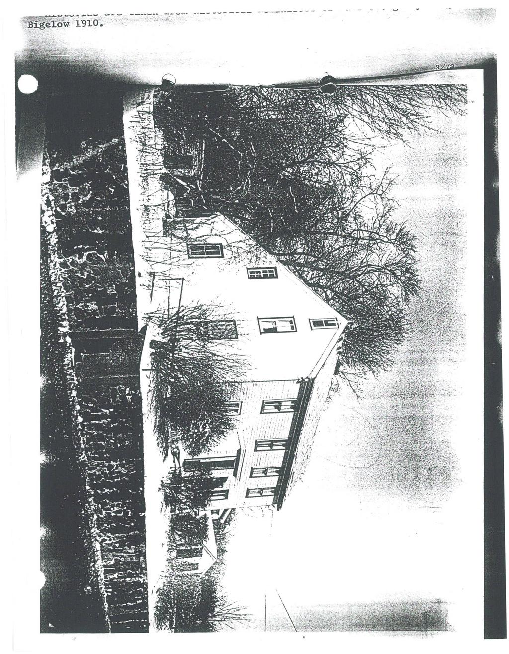
![BUILDING FORM ARCHITECTURAL DESCRIPTION [] see continuation sheet Describe architectural features. Evaluate the characteristics of this building in terms of other buildings within the community.](/docs-images/89/100548900/images/22-0.jpg "Although this house is not mentioned in the town histories as one of 's historic residences, its form and style indicate that it would have been built during the late Federal period, probably between")
22 BUILDING FORM ARCHITECTURAL DESCRIPTION [] see continuation sheet Describe architectural features. Evaluate the characteristics of this building in terms of other buildings within the community. Although this house is not mentioned in the town histories as one of 's historic residences, its form and style indicate that it would have been built during the late Federal period, probably between 1825 and It is a tall, five- by two-bay, 2 1I2-story bouse, one-room deep, with a pair of rear chimneys. A one-story shed-roofed rear leanto gives the west end a near salt-box profile. Most of the windows are tall 9-over-9-sash, with molded surrounds. The main entry, which is altered by a twentieth-century surround, has a 6-panel door with glass in the top two panels, and full-length, divided sidelights that signal the approach of the Greek Revival period. Other architectural detail includes a molded, boxed cornice, without an overhang at the gable-ends, and a prominent bed molding along the facade. HISTORICAL NARRATIVE [X] see continuation sheet Explain history of the building. Explain its associations with local (or state) history. Include uses of the building, and the role(s) the owners/occupants played within the community. This house is the only survivor of what was once a line of at least six eighteenth- and early nineteenthcentury houses standing along the north shore of Lake Williams on what had been the "Great Road", later part of the Boston Post Road, and eventually became Lakeside Avenue. Further research will be necessary to verify its history, for which local documentation is somewhat confusing. Deed and map research reveals that at several points in the nineteenth century more than one property along this section of Lakeside Avenue was owned by the same owner, and that the houses here went back and forth between members of the Howe, Brigham, and Holyoke families, especially, probably at times with one holding a mortgage for another. Because of the demolition of at least four buildings on either side of this house, it is also difficult to identify through map evidence. It appears to have been built between the eighteenth-century houses of Eleazer How to the west and Ephraim Barber to the east (both demolished-see Form #54). No house is shown in this position on the map of 1803, but by 1830 a house is shown here, belonging to "D. Brown." This would be David Brown, who by 1832 had sold the house to Samuel B. Maynard. (Carpenter David Brown [b. 1805], with Elbridge Howe, built the old town hall in If this is that David Brown, it is likely that he constructed this house himself). Although deeds indicate that William F. Holyoke, who lived further east on the street, bought the property by 1840, that transaction may represent a loan or mortgage, as S.B. Maynard is still shown as the owner on the maps of 1856 and A mortgage was foreclosed on the property at least once just after the Civil War, and deeds from 1867 and 1870 may also represent a mortgage on the property held by Edward Rice, apparently Mr. Maynard's brother-in-law, Edward G. Rice. (See Form # Northborough Road). (Cont.) BIBLIOGRAPHY and/or REFERENCES [] see continuation sheet Maps and atlases: 1853, , 1875, 1889, Bigelow. Directories and Real Estate valuations. Historical Society: House files. [ ] Recommended for listing in the National Register of Historic Places. If checked. a completed National Register Criteria Statement form is attached.
23 INVENTORY FORM CONTINUATION SHEET Community Property Brown/Maynard House.1assachusetts Historical Commission 80 Boylston Street Boston, Massachusetts Area(s) AJ Form No. 649 HISTORICAL NARRATIVE, cont. In 1899, a few years after Samuel Maynard's death, three of his heirs deeded the property to his daughter, Sarah Maynard Jackman. She and her husband, J.V. Jackman, principal of the Bigelow School, lived nearby at 183 Lakeside Avenue. Samuel Maynard's widow, Sarah (Rice), survived him, and probably remained here until her death, along with another daughter, Harriet Maynard. In 1908 the property was sold to Samuel Kinder(s). The Kinder family lived here for many hears; in 1930 the house was still occupied by Mrs. Jeanette Kinder.
Town Kingston. Place (neighborhood or village) Silver I ake. Address 279 Grove Street. Historic Name. Style/Form. Roof asphalt shingles
 Silver I ake. Address 279 Grove Street. Historic Name. Style/Form. Roof asphalt shingles") USGS Quad Area(s) Form Number 379 Town Kingston Place (neighborhood or village) Silver I ake Address 279 Grove Street Historic Name Horace Maglathlin Hnngp Uses: Present residence Original residence of
USGS Quad Area(s) Form Number 379 Town Kingston Place (neighborhood or village) Silver I ake Address 279 Grove Street Historic Name Horace Maglathlin Hnngp Uses: Present residence Original residence of
Assessor's number USGS Quad Area(s) Form Number. Town Kingston. Place (neighborhood or village) Address 24 School Street Historic Name
 Form Number. Town Kingston. Place (neighborhood or village) Address 24 School Street Historic Name") FORM B - BUILDING Massachusetts Historical Commission 220 Morrissey Blvd. Boston, Massachusetts 02125 Assessor's number USGS Quad Area(s) Form Number 374 Town Kingston Place (neighborhood or village) Address
FORM B - BUILDING Massachusetts Historical Commission 220 Morrissey Blvd. Boston, Massachusetts 02125 Assessor's number USGS Quad Area(s) Form Number 374 Town Kingston Place (neighborhood or village) Address
Assessor's number USGS Quad Area(s) Form Number. Town Kingston Place (neighborhood or village) Address 92 Si immer Street Historic Name
 Form Number. Town Kingston Place (neighborhood or village) Address 92 Si immer Street Historic Name") FORM B-BUILDING Massachusetts Historical Commission 220 Morrissey Blvd. Assessor's number USGS Quad Area(s) Form Number 269 Town Kingston Place (neighborhood or village) Address 92 Si immer Street Historic
FORM B-BUILDING Massachusetts Historical Commission 220 Morrissey Blvd. Assessor's number USGS Quad Area(s) Form Number 269 Town Kingston Place (neighborhood or village) Address 92 Si immer Street Historic
\ Town. St,- F O R M B - BUILDING. Massachusetts Historical Commission 80 Boylston Street Boston, Massachusetts 02116
 F O R M B - BUILDING Massachusetts Historical Commission 80 Boylston Street Boston, Massachusetts 02116 Assessor's number USGSQuad 33/160-10 Boston South \ Town Br Area(s) Form Number BKL.616
Place (neighborhood or village) Address 4 Flm Street Historic Name. Foundation granite
 Address 4 Flm Street Historic Name. Foundation granite") rorm B - BUILDING Assessor's number USGS Quad Area(s) Form Number 221 Town Kingston Place (neighborhood or village) Address 4 Flm Street Historic Name Augustus Pope House Uses: Present residence Original
rorm B - BUILDING Assessor's number USGS Quad Area(s) Form Number 221 Town Kingston Place (neighborhood or village) Address 4 Flm Street Historic Name Augustus Pope House Uses: Present residence Original
o Approximate distance of building from street Ci ty Home City of Marlborough 50' 37M-7-77 FORM B - BUILDING In Area no. Form no.
 FORM B - BUILDING In Area no. Form no. MASSACHUSETTS HISTORICAL COMMISSION Office oi the Secretary, State House, Boston 104 MarlborQugh 359Bo1ton Street me Ci ty Home Dept. of Recreation/ Open Space City
BOSToN POST RO,4..b been reduced. in si.:.ze,dormers are FORM B - BUILDING. In Area no. Form no.
 FORM B - BUILDING MASSACHUSETTS HISTORIC COMMISSION Office of the Secretary, state House, Boston,~.;1.' _: '.{.. 1. Town Marl borough In Area no. Form no. 91 Address 31 Northborough _~_Zo_a_d _ Name Samuel
r 5 .._-. tj~lj Q ~ Q r JUL &3 OD 00 --:::--;~-;:-V_N~I:..-(}...:...N.:... 5 r U I:l n 0 0 Q ~ r-cj-cj--o-o-" S
 FORM B - BUILDING In Area no. Form no. 11,1ASSACHUSETTS HISTORICAL COMMISSION Off" 0 tho cs r». oto:>. " cto:>to u""",,,, U"",t"..._-. 1. Town :Harlborou:(r~ Address 115 Union.3treet Name Fairviev; Farm
Plymouth 163. Place (neighborhood or village)
") USGS Quad Area(s) Form Number Plymouth 163 Town Place (neighborhood or village) Address 2 Cross Street Historic Name Uses: Present residence Original residence Date of Construction c.1850 Source maps Style/Form
USGS Quad Area(s) Form Number Plymouth 163 Town Place (neighborhood or village) Address 2 Cross Street Historic Name Uses: Present residence Original residence Date of Construction c.1850 Source maps Style/Form
Commonwealth of Massachusetts Massachusetts Historical Commission 220 Morrissey Boulevard, Boston, Massachusetts
 Inventory No: Historic Name: Common Name: Address: HRV.56 Barnard, E. House Blanchard - Bromfield, H. House 12 Old Boston Rd City/Town: Village/Neighborhood: Harvard Harvard Center Local No: 22B-9.01;
FORM A - AREA MASSACHUSETTS HISTORICAL COMMISSION MASSACHUSETTS ARCHIVES BUILDING 220 MORRISSEY BOULEVARD BOSTON, MASSACHUSETTS 02125
 FORM A - AREA MASSACHUSETTS HISTORICAL COMMISSION MASSACHUSETTS ARCHIVES BUILDING 220 MORRISSEY BOULEVARD BOSTON, MASSACHUSETTS 02125 Assessor s Sheets USGS Quad Area Letter Form Numbers in Area Town Northborough
Place (neighborhood or village) Address fift/fin Slimmer Street. Historic Name. Source maps. Exterior Material: Roof asphalt shingles
 Address fift/fin Slimmer Street. Historic Name. Source maps. Exterior Material: Roof asphalt shingles") 7 a r USGS Quad Area(s) Form Number 260 Town Place (neighborhood or village) Address fift/fin Slimmer Street Historic Name Keith's store Uses: Present oommercial Original commercial Date of Construction
7 a r USGS Quad Area(s) Form Number 260 Town Place (neighborhood or village) Address fift/fin Slimmer Street Historic Name Keith's store Uses: Present oommercial Original commercial Date of Construction
Assessor's number 46/100. Town. Address. luses: Present _. Source Melville Style/Form. Condition good. Moved X no.
 FORM B - BUILDING Assessor's number 46/100 USGS Quad Plymouth Area(s) Form Number 75 Massachusetts Historical Commission Massachusetts Archives Facility 220 Morrissey Boulevard Boston, Massachusetts 02125
Commonwealth of Massachusetts Massachusetts Historical Commission 220 Morrissey Boulevard, Boston, Massachusetts
 Inventory No: Historic Name: SBR.45 Newton, Moses House Common Name: Address: 15 Main St City/Town: Village/Neighborhood: Southborough Southborough Local No: 54-28 Year Constructed: Architect(s): Architectural
Loveland Historic Preservation Commission Staff Report
 COMMUNITY & STRATEGIC PLANNING Civic Center 500 East Third Street Loveland, Colorado 80537 (970) 962-2577 FAX (970) 962-2945 TDD (970) 962-2620 www.cityofloveland.org Loveland Historic Preservation Commission
NEW HAMPSHIRE HISTORIC PROPERTY DOCUMENTATION LESSARD HOUSE NH STATE NO Second Avenue, Berlin, Coos County, New Hampshire
 NEW HAMPSHIRE HISTORIC PROPERTY DOCUMENTATION LESSARD HOUSE NH STATE NO. 695 Location:, Berlin, Coos County, New Hampshire USGS Berlin Quadrangle UTM Coordinates: Z19 4926222N 326139E Present Owner: Present
Commonwealth of Massachusetts Massachusetts Historical Commission 220 Morrissey Boulevard, Boston, Massachusetts
 Inventory No: Historic Name: HRV.13 Blanchard, William House Common Name: Address: 16 Ayer Rd City/Town: Village/Neighborhood: Local No: Harvard Harvard Center 17D-08; 50; E10 Year Constructed: Architect(s):
Commonwealth of Massachusetts Massachusetts Historical Commission 220 Morrissey Boulevard, Boston, Massachusetts
 Inventory No: Historic Name: Common Name: Address: SBR.54 Walker, Francis W. House Mahoney, Daniel F. House 6 Main St City/Town: Village/Neighborhood: Local No: 54-65 Year Constructed: c 1840 Architect(s):
RECEIVED Follow Massachusetts Historical Commission Survey Manual instructions when completing this form.
 / AUG 2 5 1998 MARS. HIST. GQMM FORM B - BUILDING Assessor's number USGS Quad Area(s) Form Number Plymouth B 17i 7r? Town Kingston Place (neighborhood or village) Address P4D Main Street Historic Name
Commonwealth of Massachusetts Massachusetts Historical Commission 220 Morrissey Boulevard, Boston, Massachusetts
 Inventory No: Historic Name: Common Name: Address: hrv.52 Bridge, Jeremiah - Stone, Dea. Isaac N. House Hartwell, Daniel - Farnsworth, J. House 23 Fairbank St City/Town: Village/Neighborhood: Harvard Harvard
.u,.." VUUULUJ)'''ill J tl/utl. FORM B - Building
'''ill J tl/utl. FORM B - Building") FORM B - Building Map and Lot # USGS Quad Form Number 113 40 y 13 Town Groton Place (neighborhood or village) Groton Center Photograph Address (3"x3" or 3-1/2x5" black andwhite only) Labelphoto on back
FORM B - Building Map and Lot # USGS Quad Form Number 113 40 y 13 Town Groton Place (neighborhood or village) Groton Center Photograph Address (3"x3" or 3-1/2x5" black andwhite only) Labelphoto on back
Architectural Inventory Form
 OAHP1403 Rev. 9/98 COLORADO CULTURAL RESOURCE SURVEY Architectural Inventory Form Official eligibility determination (OAHP use only) Date Initials Determined Eligible- NR Determined Not Eligible- NR Determined
Submitted to Fire Station 8 Working Group and Arlington County Public Library HOUSE AT 2211 NORTH CULPEPER STREET
 Submitted to Fire Station 8 Working Group and Arlington County Public Library HOUSE AT 2211 NORTH CULPEPER STREET Location: 2211 North Culpeper Street, Arlington, Virginia. Significance: The house at 2211
Architectural Inventory Form
 310 N Spruce St 5SM1775 Official Eligibility Determination OAHP1403 (OAHP use only) COLORADO CULTURAL RESOURCE SURVEY Rev. 9/98 Date Initials Determined Eligible National Register Determined Not Eligible
NEW HAMPSHIRE HISTORIC PROPERTY DOCUMENTATION DINARDO-DUPUIS HOUSE NH STATE NO Wight Street, Berlin, Coos County, New Hampshire
 NEW HAMPSHIRE HISTORIC PROPERTY DOCUMENTATION DINARDO-DUPUIS HOUSE NH STATE NO. 696 Location:, Berlin, Coos County, New Hampshire USGS Berlin Quadrangle UTM Coordinates: Z19 4926650N 325990E Present Owner:
BUILDING INVENTORY SHEET
 Specifics *Address : BUILDING INVENTORY SHEET 24 Locke Road Longitude : Latitude : 1806 Name: A. Knowles Esq. (10) * 1841 Name : Captain Jesse Knowle s 1892 Name: E. A. Knowle s Current Owner: Jack Lessard
town Kingston Place (neighborhood or village) Major Alterations (with dates) Condition good
 Major Alterations (with dates) Condition good") number USGS Quad Form Number 350 town Place (neighborhood or village) Address 6 Prospect Street Historic Name Cnhh ft Drew Factory Uses: Present factory Original factory Date of Construction c.1848 Source
number USGS Quad Form Number 350 town Place (neighborhood or village) Address 6 Prospect Street Historic Name Cnhh ft Drew Factory Uses: Present factory Original factory Date of Construction c.1848 Source
DHR Resource Number: AVON STREET
 DHR Resource Number: 104-5082-0089 309 AVON STREET 309 Avon Street Parcel ID: 580127000 DHR Resource Number: 104-5082-0089 Primary Resource: Store, Spudnuts (contributing) Date: 1960 Commercial Style Site
BUILDING INVENTORY SHEE T
 Specific s *Address : BUILDING INVENTORY SHEE T 22 Exeter Road Longitude : Latitude : 1806 Name: J. Philbrick (19) *1841 Name: Jonathan Philbrick (19 ) 1892 Name: Andrew J. Philbrick Current Owner: Richard
BUILDING INVENTORY SHEE T
 Specifics *Address : BUILDING INVENTORY SHEE T 36 Mace Road AREA 5 Longitude : Latitude : 1806 Name : N/A * 1841 Name: John Mace (8) 1892 Name : G. Mace? Current Owner : Original Owner: Date Built: after
1718 Jefferson Park Avenue (DHR # )
") JEFFERSON PARK AVENUE 1718 Jefferson Park Avenue (DHR # 104-5092-0068) STREET ADDRESS: 1718 Jefferson Park Avenue MAP & PARCEL: 11-56 PRESENT ZONING: R-UHD ORIGINAL OWNER: P. D. Glison ORIGINAL USE: PRESENT
JEFFERSON PARK AVENUE 1718 Jefferson Park Avenue (DHR # 104-5092-0068) STREET ADDRESS: 1718 Jefferson Park Avenue MAP & PARCEL: 11-56 PRESENT ZONING: R-UHD ORIGINAL OWNER: P. D. Glison ORIGINAL USE: PRESENT
Property INVENTORY FORM CONTINUATION SHEET. Marlborough. West Main Street
 FORMA-AREA /' Assessor's Sheets / 'USGS Quad.-' I Area Letter Form Numbers in Area _6_9_, _81_~1 I I I 184, 136-141, 210-244 Town Place (neighborhood or village) city center Name of Area " Present Use
Edward Doran Davison Sr. The Lumber King
 Edward Doran Davison Sr. The Lumber King Edward Doran Davison Senior was born in 1819 at Mill Village, Queens County. Growing up under the guidance of his maternal Aunt Catherine Doran, a woman with savvy
1 WAY STREET. Private Residence
 1 WAY STREET VG BALDWIN STREET Late 19th C. (cal 1898) 21/2 storey brick gable roofed residential building with a projecting central bay with 1/1 windows in each of the three faces on the first two storeys
City of Loveland Community and Strategic Planning Civic Center 500 East 3 rd Street Loveland, Colorado Fax
 City of Loveland Community and Strategic Planning Civic Center 500 East 3 rd Street Loveland, Colorado 80537 970-962-2577 Fax 970-962-2900 Loveland City Council Staff Report From: Matt Robenalt, Community
Historic Property Report
 Location Address: 1224 E ROCKWOOD PINES RD, SPOKANE, WA 99203 Tax No/Parcel No: 35294.0243 Plat/Block/Lot: ROCKWOOD PINES 2ND L15 Geographic Areas: Spokane County, SPOKANE NW Quadrangle, T25R43E29 Information
Mary J. Berg House 2517 Regent Street
 CITY OF BERKELEY Ordinance #4694 N.S. LANDMARK APPLICATION Mary J. Berg House 2517 Regent Street Additional Photographs Streetscape showing 2511, 2517 & 2521 Regent Street 2517 Regent Street front façade
Poten ally Eligible Structures
 Poten ally Eligible Structures (Note: Construction dates for many properties are based on County Assessor s records and have not been verified by historical research.) Fifteen commercial or public buildings
Memorandum. 233 Wilshire Boulevard, Suite 130, Santa Monica, CA INTERNET TEL FAX
 TO: Scott Albright, City of Santa Monica DATE: April 29, 2010 CC: FROM: PCR Services RE: PRELIMINARY HISTORIC ASSESSMENT: 2501 2ND TH STREET, APN As requested by City s staff, PCR Services Corporation
COUNCIL MEETMI 5 JUL f 5 08
 COUNCIL MEETMI 5 JUL f 5 08 BY-LAW NO. 2008-XXX A BY-LAW TO DESIGNATE 1345 WOODBINE ROAD, TO BE OF CULTURAL HERITAGE VALUE AND INTEREST PURSUANT TO THE PROVISIONS OF THE Oh TARIO HERITAGE A CT (R.S.O.
STAFF REPORT NEW BEDFORD HISTORICAL COMMISSION MEETING July 10, 2017
 PATRICK J. SULLIVAN DIRECTOR City of New Bedford Department of Planning, Housing & Community Development 608 Pleasant St, New Bedford, Massachusetts 02740 Telephone: (508) 979.1500 Facsimile: (508) 979.1575
Commonwealth of Massachusetts Massachusetts Historical Commission 220 Morrissey Boulevard, Boston, Massachusetts
 Inventory No: Historic Name: HRV.11 Bromfield School Common Name: Address: 24 Massachusetts Ave City/Town: Village/Neighborhood: Local No: Harvard Harvard Center 22B-40; 25; OC8 Year Constructed: Architect(s):
Town/City: Address: Source: Style/Form: Condition: Acreage:
 FORM B BUILDING MASSACHUSETTS HISTORICAL COMMISSION MASSACHUSETTS ARCHIVES BUILDING 220 MORRISSEY BOULEVARD BOSTON, MASSACHUSETTS 02125 Photograph (view from ) Assessor s Number USGS Quad Area(s) Form
A Walking Tour of Heritage Burlington Art Gallery of Burlington Neighbourhood Walking Tour
 A Walking Tour of Heritage Burlington Art Gallery of Burlington Neighbourhood Walking Tour Educate, Inform and Engage the community on Burlington s Heritage The Ontario Heritage Act provides a framework
Memorandum. Overview. Background Information. To: Scott Albright, City of Santa Monica Date: 04/22/2013 Jan Ostashay, Principal OAC
 Memorandum P.O. Box 542 Long Beach, CA 562.500.9451 HISTORICS@AOL.COM To: Scott Albright, City of Santa Monica Date: 04/22/2013 From: Jan Ostashay, Principal OAC Re: PRELIMINARY HISTORICAL ASSESSMENT:
PROTECTED LANDMARK DESIGNATION REPORT
 PROTECTED LANDMARK DESIGNATION REPORT LANDMARK NAME: Fox-Kuhlman Building OWNERS: Michael Shapiro (305 Travis); Carolyn Wenglar (307 Travis) APPLICANTS: Same as Owners LOCATION: 305-307 Travis - Main Street
Commonwealth of Massachusetts Massachusetts Historical Commission 220 Morrissey Boulevard, Boston, Massachusetts
 Inventory No: Historic Name: Common Name: Address: NWB.229 Washington Street Methodist Episcopal Church Temple Achavas Achim 53 1/2 Washington St City/Town: Newburyport Village/Neighborhood: Local No:
List of Landmarks. Below are the properties currently designated as Cary Historic Landmarks:
 Historic Landmarks Overview The Town of Cary designates Cary Historic Landmarks as a way to preserve buildings that are historically, architecturally, or culturally significant to Cary. The Town Council
119 Maywood Lane (DHR # )
") MAYWOOD LANE 119 Maywood Lane (DHR # 104-5092-0058) STREET ADDRESS: 119 Maywood Lane MAP & PARCEL: 11-63 PRESENT ZONING: R-2U ORIGINAL OWNER: B. R. Bibb ORIGINAL USE: PRESENT USE: PRESENT OWNER: Maywood
MAYWOOD LANE 119 Maywood Lane (DHR # 104-5092-0058) STREET ADDRESS: 119 Maywood Lane MAP & PARCEL: 11-63 PRESENT ZONING: R-2U ORIGINAL OWNER: B. R. Bibb ORIGINAL USE: PRESENT USE: PRESENT OWNER: Maywood
1. Name of Property. historic name Coonradt, Ernest E. and Ruth G., House. other names/site number. 2. Location
 Site Inventory Form State Inventory No. 09-00875 New Supplemental State Historical Society of Iowa Part of a district with known boundaries (enter inventory no.) 09-00962 (November 2005) Relationship:
Maryland Historical Trust Inventory No Maryland Inventory of Historic Properties Form
 Inventory No. 15 21 Maryland Inventory of 1. Name of Property (indicate preferred name) historic John O Etchison House other 2. Location street and number 25611 Long Corner Road not for publication city,
STATE OF IOWA. Historical and Architectural Reconnaissance Survey for 2008 Flood Projects in Elkader, Clayton County
 STATE OF IOWA CHESTER J. CULVER GOVERNOR PATTY JUDGE LT. GOVERNOR DEPARTMENT OF PUBLIC DEFENSE IOWA HOMELAND SECURITY AND EMERGENCY MANAGEMENT DIVISION DAVID L. MILLER, ADMINISTRATOR Historical and Architectural
HISTORIC RESOURCES INVENTORY - BUILDING AND STRUCTURES. One Constitution Plaza, 2nd Floor, Hartford CT 06103
 HISTORIC RESOURCES INVENTORY - BUILDING AND STRUCTURES Please send completed form to: Stacey Vairo, National Register and State Register Coordinator, Connecticut Commission State Historic on Culture Preservation
2. Historic name: Spalding: Caroline Residence. 3. Street or rural address: 1006 North Crescent Drive. Cftv Beverly Hills Zip County Los Angeles
 state or L~aIlTornIa I ne Hesources Agency Ser. No. ~ I ~ 1. ) ~5 DEPARTMENT OF PARKS AND RECREATION HABS HAER NR ~ SHL Loc_ UTM: A ll-3~41~) ~ B HISTORIC RESOURCES INVENTORY C D IDENTIFICATION 1. Common
1. Name of Property. historic name Beyer, Christian P and Olive, House. other names/site number. 2. Location
 Site Inventory Form State Inventory No. 09-00724 New Supplemental State Historical Society of Iowa Part of a district with known boundaries (enter inventory no.) 09-00621 (November 2005) Relationship:
Site Inventory Form State Inventory No New Supplemental
 Site Inventory Form State Inventory No. 70-00940 New Supplemental State Historical Society of Iowa Part of a district with known boundaries (enter inventory no.) (December 1, 1999) Relationship: Contributing
Commonwealth of Massachusetts Massachusetts Historical Commission 220 Morrissey Boulevard, Boston, Massachusetts
 Inventory No: Historic Name: Common Name: Address: HRV.61 Harvard Evangelical Congregational Church Harvard Orthodox Church 5 Still River Rd City/Town: Village/Neighborhood: Harvard Harvard Center Local
Maryland Historical Trust Inventory No. PG: 81B-003 Maryland Inventory of Historic Properties Form
 Maryland Historical Trust Inventory No. PG: 81B-003 Maryland Inventory of 1. Name of Property (indicate preferred name) historic other 2. Location Thrift Schoolhouse street and number 11110 Thrift Road
Administration Building YMCA Branch To Remain Intact
 Project Site BOSTON LANDMARKS COMMISSION The YMCA of Greater Boston, Inc. and Huntington Affordable Housing Limited Partnership (together, Building was originally comprised of three (3) separate buildings
Wyman Historic District
 Wyman Historic District DISTRICT DESCRIPTION The Wyman Historic District is a large district that represents the many architectural styles in fashion between the late 1800s through 1955. With the establishment
Los Angeles Department of City Planning RECOMMENDATION REPORT
 Los Angeles Department of City Planning RECOMMENDATION REPORT CULTURAL HERITAGE COMMISSION HEARING DATE: June 16, 2011 TIME: 10:00 AM PLACE: City Hall, Room 1010 200 N. Spring Street Los Angeles, CA 90012
I Marlborough I F N, ,
 ORMA-AREA Assessor's Sheets USGS Quad Area Letter orm Numbers in Area (.tt:'1oj\, / ~_1Sk;1?.;U I 69,70 81, 82 ~.J~ (ff~'7,,:::."".'/ t """lj' /. Town I Marlborough I N, 162-177, 376-406 Marlborough./
other names/site number Downtown Survey Map # J-135
 Site Inventory Form State Inventory No. 29-01109 New Supplemental State Historical Society of Iowa Part of a district with known boundaries (enter inventory no.) 29-03685, 29-00001 (November 2005) Relationship:
The W. D. Beaty House
 The W. D. Beaty House This report was written on 28 February 1990 1. Name and location of the property: The property known as the W. D. Beaty House is located at 2400 Park Lane in Charlotte, N. C. 2. Name,
Site Inventory Form State Inventory No New Supplemental
 Site Inventory Form State Inventory No. 70-00938 New Supplemental State Historical Society of Iowa Part of a district with known boundaries (enter inventory no.) (December 1, 1999) Relationship: Contributing
IMPORTANT NOTICE. Architectural Inventory Form COLORADO CULTURAL RESOURCE SURVEY I. IDENTIFICATION. 519 West 19th Street 5PE.6460
 IMPORTANT NOTICE OAHP1403 Rev. 9/98 COLORADO CULTURAL RESOURCE SURVEY Architectural Inventory Form Page 1 This survey form represents an UNOFFICIAL COPY and is provided for informational purposes only.
Alterations to a Designated Heritage Property and Authority to Amend a Heritage Easement Agreement, 80 Bell Estate Road (Thornbeck-Bell House)
") STAFF REPORT ACTION REQUIRED Alterations to a Designated Heritage Property and Authority to Amend a Heritage Easement Agreement, 80 Bell Estate Road (Thornbeck-Bell House) Date: October 4, 2011 To: From:
STAFF REPORT ACTION REQUIRED Alterations to a Designated Heritage Property and Authority to Amend a Heritage Easement Agreement, 80 Bell Estate Road (Thornbeck-Bell House) Date: October 4, 2011 To: From:
Stewkley s Historic Public Houses
 Stewkley s Historic Public Houses Buckinghamshire Archaeological Society BUCKINGHAMSHIRE HISTORIC PUBS SURVEY / March 2013 SURVEY: Stewkley Local History Group REPORT: Jill Scott Report number BAS/2013-03
Current Functions (Enter categories from instructions) 02D01: Commerce / financial / savings and loan 11D03: doctor office chiropractic
 02D01: Commerce / financial / savings and loan 11D03: doctor office chiropractic") Site Inventory Form State Inventory No. 92-00550 New Supplemental State Historical Society of Iowa Part of a district with known boundaries (enter inventory no.) 92-00349 (November 2005) Relationship:
Site Inventory Form State Inventory No. 92-00550 New Supplemental State Historical Society of Iowa Part of a district with known boundaries (enter inventory no.) 92-00349 (November 2005) Relationship:
IMPORTANT NOTICE. Architectural Inventory Form COLORADO CULTURAL RESOURCE SURVEY I. IDENTIFICATION North Grand Avenue 5PE.
 IMPORTANT NOTICE OAHP1403 Rev. 9/98 COLORADO CULTURAL RESOURCE SURVEY Architectural Inventory Form Page 1 This survey form represents an UNOFFICIAL COPY and is provided for informational purposes only.
Richardson s Bakery. Description of Historic Place. Heritage Value of Historic Place
 HISTORIC RESOURCES 2013 City of Medicine Hat Richardson s Bakery Date of Construction 1899 Address 720-4 (Montreal) Street SE Original Owner Henry McNeely Neighbourhood River Flats Legal 1491;24;11 Description
IMPORTANT NOTICE. Architectural Inventory Form COLORADO CULTURAL RESOURCE SURVEY I. IDENTIFICATION North Grand Avenue 5PE.
 IMPORTANT NOTICE OAHP1403 Rev. 9/98 COLORADO CULTURAL RESOURCE SURVEY Architectural Inventory Form Page 1 This survey form represents an UNOFFICIAL COPY and is provided for informational purposes only.
other names/site number Downtown Survey Map # J-143
 Site Inventory Form State Inventory No. 29-01123 New Supplemental State Historical Society of Iowa Part of a district with known boundaries (enter inventory no.) 29-03685, 29-00001 (November 2005) Relationship:
IMPORTANT NOTICE. Architectural Inventory Form COLORADO CULTURAL RESOURCE SURVEY I. IDENTIFICATION. 210 West 20th Street 5PE.6616
 IMPORTANT NOTICE OAHP1403 Rev. 9/98 COLORADO CULTURAL RESOURCE SURVEY Architectural Inventory Form Page 1 This survey form represents an UNOFFICIAL COPY and is provided for informational purposes only.
SURVEY OF PUBLIC HOUSES. Tingewick
 BUCKINGHAMSHIRE ARCHAEOLOGICAL SOCIETY HISTORIC BUILDINGS GROUP SURVEY OF PUBLIC HOUSES IN THE PARISH OF Tingewick BUCKINGHAMSHIRE A record of extant buildings that are currently or were formerly public
Town of Cary, North Carolina Rezoning Staff Report 13-REZ-13 An Zou Property Town Council Meeting November 21, 2013
 Town of Cary, North Carolina Rezoning Staff Report 13-REZ-13 An Zou Property Town Council Meeting November 21, 2013 REQUEST To amend the Town of Cary Official Zoning Map by rezoning 0.63 acres located
Section 7: HIGH STREET and The Cottage, Singleborough Lane (Sequential numbers south side, none north side)
") Buckinghamshire Archaeological Society HISTORIC BUILDINGS GROUP Great Horwood Village Survey : October 2011 Section 7: HIGH STREET and The Cottage, Singleborough Lane (Sequential numbers south side, none
Buckinghamshire Archaeological Society HISTORIC BUILDINGS GROUP Great Horwood Village Survey : October 2011 Section 7: HIGH STREET and The Cottage, Singleborough Lane (Sequential numbers south side, none
Current Functions (Enter categories from instructions) Materials (Enter categories from instructions)
 Materials (Enter categories from instructions)") Site Inventory Form State Inventory No. 29-00089 New Supplemental State Historical Society of Iowa Part of a district with known boundaries (enter inventory no.) 29-03522 (November 2005) Relationship:
Site Inventory Form State Inventory No. 29-00089 New Supplemental State Historical Society of Iowa Part of a district with known boundaries (enter inventory no.) 29-03522 (November 2005) Relationship:
Architectural Inventory Form
 OAHP1403 Rev. 9/98 COLORADO CULTURAL RESOURCE SURVEY Architectural Inventory Form Official eligibility determination (OAHP use only) Date Initials Determined Eligible- NR Determined Not Eligible- NR Determined
Property Name Haxton-Griffin Farm Location Athens vic., Greene County, New York NATIONAL REGISTER OF HISTORIC PLACES CONTINUATION SHEET
 Section Number 7 Page 1 7. Narrative Description Location & Setting The Haxton-Griffin Farm is located on the west side of the Hudson River, about one-half mile from the river and less than two miles southwest
Steve Mizokami Senior Planner, City of Santa Monica. From: Christine Lazzaretto, Principal; Heather Goers, Architectural Historian Date: April 3, 2018
 To: Steve Mizokami Senior Planner, City of Santa Monica 1 From: Christine Lazzaretto, Principal; Heather Goers, Architectural Historian Date: April 3, 2018 INTRODUCTION Per your request, Historic Resources
FAIRMOUNT HILL: Fairmount Street through #64, Newton Street from #39 to end.
 MARLBOROUGH SURVEY OF mstoric, ARCHITECTURAL, AND CULTURAL RESOURCES: RESOURCES POTENTIALLY ELIGffiLE FOR THE NATIONAL REGISTER OF mstoric PLACES NOTE: Only thirteen historic resources in Marlborough are
laaj 1-11S90- NATIONAL REGISTER OMB No NPS Form (Rev, 8-86)
") NPS Form 10-900 (Rev, 8-86) OMB No. 1024-0018 United States Departaent of the Interior National Park Service NATIONAL REGISTER OF HISTORIC PLACES REGISTRATION FORM J laaj 1-11S90- NATIONAL REGISTER i 1.
NPS Form 10-900 (Rev, 8-86) OMB No. 1024-0018 United States Departaent of the Interior National Park Service NATIONAL REGISTER OF HISTORIC PLACES REGISTRATION FORM J laaj 1-11S90- NATIONAL REGISTER i 1.
Town/City: Address: 14 Congress Street. Source: historic maps & directories. Style/Form: Roof: Condition: Acreage:
 FORM B BUILDING MASSACHUSETTS ARCHIVES BUILDING 220 MORRISSEY BOULEVARD BOSTON, MASSACHUSETTS 02125 Assessor s Number USGS Quad 03-026-00017 Area(s) Worcester North Form Number V WOR.1045 Town/City: Worcester
VIRGINIA BEACH HISTORICAL REGISTER PROGRAM INFORMATION AND NOMINATION/APPLICATION FORM INSTRUCTIONS
 VIRGINIA BEACH HISTORICAL REGISTER PROGRAM INFORMATION AND NOMINATION/APPLICATION FORM INSTRUCTIONS Program Information: The Virginia Beach Historical Register was established by the Virginia Beach City
Sickels Laundry and Dry Cleaning
 Site Inventory Form State Inventory No. 29-03677 New Supplemental State Historical Society of Iowa Part of a district with known boundaries (enter inventory no.) 29-03685 (November 2005) Relationship:
Architectural Inventory Form
 OAHP1403 Rev. 9/98 COLORADO CULTURAL RESOURCE SURVEY Architectural Inventory Form Official eligibility determination (OAHP use only) Date Initials Determined Eligible- NR Determined Not Eligible- NR Determined
1. Name of Property. other names/site number Downtown Survey Map # DT- 053
 Site Inventory Form State Inventory No. 92-00510 New Supplemental State Historical Society of Iowa Part of a district with known boundaries (enter inventory no.) 92-00349 (November 2005) Relationship:
NEW HAMPSHIRE HISTORIC PROPERTY DOCUMENTATION BICKFORD RENTAL HOUSE NH STATE NO First Avenue, Berlin, Coos County, New Hampshire
 NEW HAMPSHIRE HISTORIC PROPERTY DOCUMENTATION BICKFORD RENTAL HOUSE NH STATE NO. 689 Location:, Berlin, Coos County, New Hampshire USGS Berlin Quadrangle UTM Coordinates: Z19 4926353N 326093E Present Owner:
Windshield Survey of McLoud, Pottawatomie County. September 12, 2007 By Jim Gabbert Architectural Historian OK/SHPO
 Windshield Survey of McLoud, Pottawatomie County September 12, 2007 By Jim Gabbert Architectural Historian OK/SHPO Purpose and Methodology The purpose of this windshield survey is to identify, based on
George Washington, Maryland, and Mount Vernon: The Cultural Landscape. Director of Archaeology, George Washington s Mount Vernon
 George Washington, Maryland, and Mount Vernon: The Cultural Landscape Luke J. Pecoraro, PhD Director of Archaeology, George Washington s Mount Vernon Late Archaic Period: 2500 1200 BC Contact Period:
_.. _.~I- o so WfrlieRB~E sr \ \ D~O. q~d 16) D O. r r;.ay n- N CENTRAL sr 10. LrWc..OL t/ s r: _.._-- FORM B - BUILDING
 D O. r r;.ay n- N CENTRAL sr 10. LrWc..OL t/ s r: _.._-- FORM B - BUILDING") FORM B - BUILDING In Area no. Form no. M.ASSACHUSETTS HISTORICAL COM1\'1ISSIO:\ Office of the Secretary, state House, Boston 1. Town. _:)--:"l. "h!)~ _"'O;". ~t~:. ---_.._-- Name 0. ::..::~lbee ~::.ouse
FORM B - BUILDING In Area no. Form no. M.ASSACHUSETTS HISTORICAL COM1\'1ISSIO:\ Office of the Secretary, state House, Boston 1. Town. _:)--:"l. "h!)~ _"'O;". ~t~:. ---_.._-- Name 0. ::..::~lbee ~::.ouse
Zip Ownership is: Public Private
 State of California The Resources Agency DEPARTMENT OF PARKS AND RECREATION HISTORIC RESOURCES INVENTORY Ser.No. (~3_()OTV HABS HAER NR ~-3 SHL UTM: A ii3~i fl~~ft~.a(~fl B C D IDENTIFICATION 1. Common
The Corporation of the TOWN OF MILTON
 Report to: From: Chair & Members of the Administration & Planning Standing Committee B. Koopmans, Acting Director of Planning and Development Date: May 13, 2013 Report No. PD-022-13 Subject: HERITAGE DESIGNATION
Memorandum. Historic Resources Inventory Survey Form 315 Palisades Avenue, 1983.
 Memorandum TO: Roxanne Tanemori, City of Santa Monica DATE: August 30, 2007 CC: FROM: Jon L. Wilson, M.Arch., Architectural Historian RE: Preliminary Historic Assessment: 315 Palisades Avenue (APN 4293-015-015)
3I6' t1' 0)vU-&--y~cJ) t y. '1'-
vU-&--y~cJ) t y. '1'-") Inventory Number REGISTER OF HISTORIC KANSAS PLACES--COVER SHEET Name of Property Dr. E. A. Lyons House Location 212 S. Kansas Ave. (street and number) Norton (city, town, or vicinity location) Lots 5
Inventory Number REGISTER OF HISTORIC KANSAS PLACES--COVER SHEET Name of Property Dr. E. A. Lyons House Location 212 S. Kansas Ave. (street and number) Norton (city, town, or vicinity location) Lots 5
1 Total Total. Current Functions (Enter categories from instructions) Materials (Enter categories from instructions)
 Materials (Enter categories from instructions)") Site Inventory Form State Inventory No. 29-03663 New Supplemental State Historical Society of Iowa Part of a district with known boundaries (enter inventory no.) (November 2005) Relationship: Contributing
Site Inventory Form State Inventory No. 29-03663 New Supplemental State Historical Society of Iowa Part of a district with known boundaries (enter inventory no.) (November 2005) Relationship: Contributing
HERITAGE PROPERTY RESEARCH AND EVALUATION REPORT
 ATTACHMENT NO. 12 HERITAGE PROPERTY RESEARCH AND EVALUATION REPORT WILLIAM CLARKE HOUSES 505-507 and 509-511 ADELAIDE STREET WEST, TORONTO Prepared by: Heritage Preservation Services City Planning Division
Architectural Inventory Form
 OAHP1403 Rev. 9/98 COLORADO CULTURAL RESOURCE SURVEY Architectural Inventory Form Official eligibility determination (OAHP use only) Date Initials Determined Eligible- NR Determined Not Eligible- NR Determined
Hastings CBD Heritage Inventory Project HEARDS JEWELLERY CENTRE
 Hastings CBD Heritage Inventory Project HEARDS JEWELLERY CENTRE Photo: R. Murray, 2012 LOCATION: Street and Number: 112-114 Heretaunga Street West City / Town: Hastings Region: Hawke s Bay LEGAL DESCRIPTION: