Responsible and Innovative Land Administration
|
|
|
- Thomasina Gallagher
- 5 years ago
- Views:
Transcription

1 Responsible and Innovative Land Administration An Example from Ethiopia 3 RD DECEMBER 2018
2 Outline A few words about NIRAS Fit-for-purpose: A low-tech disruptive approach? The REILA Project in Ethiopia Bernd Eversmann Technical Director Land, NIRAS International Consulting 2

3 NIRAS International Consulting In 2018, more than 300 in-house staff 27 Offices in Europe, Asia Latin America and Africa 300 projects with > 1500 project staff members
4 4 Increasing Pressure on Land Current Land Administration Solutions don t scale well

5 5 Increasing Pressure on Land Current Land Administration Solutions don t scale well

6 6 Increasing Pressure on Land Current Land Administration Solutions don t scale well
7 7 Increasing Pressure on Land Current Land Administration Solutions don t scale well


8 8 Increasing Pressure on Land Current Land Administration Solutions don t scale well ~ 70 % of the world s population have no access to formal land administration services. Only 25% of the approx. 6 billion land parcels worldwide have robust security of tenure. In 15 countries assessed by PRINDEX, an average of 25% of the population felt their tenure rights were not safe. Sources (clockwise from u.l.): Reliefweb, The Guardian, Gates Foundation, PRINDEX

9 Mass Registration in Cambodia Towards a fit-for-purpose approach for systematic registration, but: Discussions about 5cm in the rice paddies. 9


10 Fit-for-purpose A Summary of some Principles Flexibility: Scale and accuracy relate to the purpose (topography, density of development, budget) rather than technical standards. Basic purposes: Include all land; provide secure tenure for all, include the use of land General boundaries rather than fixed boundaries: using general boundaries to delineate land areas will be sufficient for most land administration purposes, especially in rural and semi-urban areas. Aerial imageries rather than field surveys: the use of highresolution satellite/ aerial imagery is sufficient for most land administration purposes, and is three to five times cheaper than field surveys. Incremental Improvement: Opportunities for updating, upgrading and improvement: building the spatial framework should be seen in a perspective of opportunities for ongoing updating, sporadic upgrading and incremental improvement whenever relevant or necessary for fulfilling land policy aims and objectives Cost-effective: Unit costs often range between 6 and 10 USD per parcel. Rwanda and Ethiopia are show cases of the method. As little as possible, as much as necessary. United States Source: FIG, GLTN

11 : FIG publication
12
")
13 The REILA Project In Ethiopia REILA = Responsible & Innovative Land Administration Bilaterally agreed project Timeframe: July June 2017 Budget: 12,800,000 Euro contribution by Finland Project area: Federal level, Benishangul-Gumuz & Amhara Regions plus trial districts in 3 additional Regions (Tigray, Oromyia and SNNP) 13

14 14 More about REILA Project Area, Objective, Purpose The overall objective of REILA is, in line with ESIF: improved livelihood and economic well-being of the rural population through promotion of sustainable land management practices The purpose of the project is to contribute towards an improved, transparent and appropriate land administration system in Ethiopia.


15 A new zero order geodetic network The geodetic network is of importance for the 2nd level land certification, as cadastral surveying and mapping must be geographically referenced to a national reference frame.


16 Occupational Standard on Rural Cadastre and Land Registration Level III AGR CLR Develop Cadastre and Land Registration Action Plan AGR CLR Undertake a Site Assessment to Conduct AGR CLR Perform Surveying Computations AGR CLR Produce Digital Data AGR CLR Develop and Use Advanced Spreadsheets AGR CLR Perform Tenure Documentation AGR CLR Deal with Land Holding Conflict AGR CLR Monitor Implementation of Work Plan/Activities AGR CLR Lead Small Teams Duration 1035 hours AGR CLR Organize, Check and Maintain Equipment and AGR CLR Collect and Set-out Basic Surveying Data AGR CLR Operate GIS Software to Spatial Input Analysis AGR CLR Prepare and Produce Maps from Orthophoto AGR CLR Store and Retrieve Spatial and Non Spatial Data AGR CLR Complete Database Back- Up and Recovery AGR CLR Process Applications and Respond to Client s Legal AGR CLR Apply Quality Control AGR CLR Improve Business Practice AGR CLR Operate Surveying Equipment AGR CLR Demarcate Land Parcel Boundary Using AGR CLR Read and Interpret Basic Image Data AGR CLR Perform Adjudication, Registration and Certification Activities for AGR CLR Operate Database Management System AGR CLR Take Instruction in Relation Transaction AGR CLR Maintain and Monitor Environmental Work AGR CLR Lead Workplace Communication AGR CLR Maintain Quality System and Continuous Improvement Processes

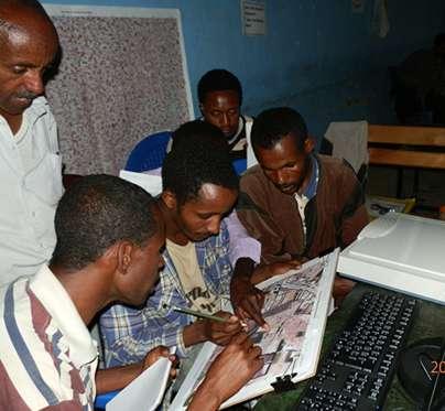
17 Method development: Imagery Trials Trial Districts (Woredas) 1 - Oromiya, Ilu Woreda 2 - SNNP, Meskan Woreda 3 - Amhara, Dembecha Woreda 4 - Tigray, Kola Temben Woreda 5 - Benishangul-Gumuz, Bambasi Woreda 6 - Benishangul-Gumuz, Bullen Woreda 7 - Benishangul-Gumuz, Kamashi Woreda 17
18 Contextualisation of the Approach Different topography, land use patterns, land cover, legislation 18


 and 7th Sept")
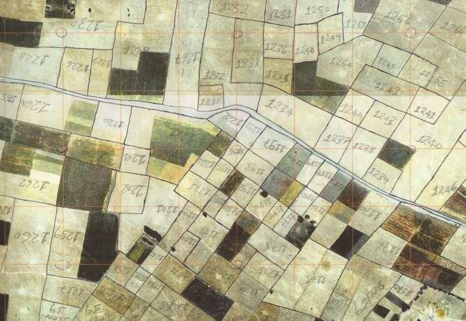
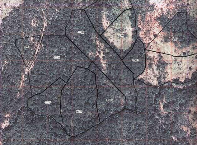
19 Contextualisation of the Approach II Postmarking in rural areas without manmade structures Comparison between precision GPS and boundaries drawn on the orthophoto The same area in Belo Jiganfoye, Benishangul-Gumuz on 3rd April (top) and 7th Sept (bottom)


20 Aerial Photography Procured and Processed for about 30,000 km 2 in the Project Area


21 Public Information and Awareness Higher level officials Land holders Region-, zone-, woreda-, kebele staff Land administration committee

22 The Legal Framework Federal constitution Federal proclamation No. 456 AM - Regional constitution AM - Land administration & Use policy and strategy AM Proclamation No 133/2005 AM- Land administration and use regulation AM Land administration and use directives BG - Regional constitution BG - Land administration & Use policy and strategy BG - Land administration proclamation BG- Land administration and use regulation BG Land administration and use directives Þ Þ Alignment with existing legal framework Contributions to federal PIA strategy

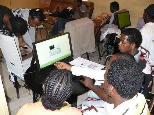
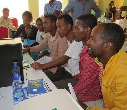
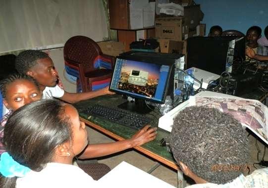
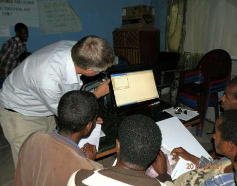
23 Training of para-surveyors In the office (GIS training)


24 and in the field, for a total of 2 weeks.
 Kebele Land Administration Committee member (legal")
25 The Field Team Surveyor (drawing the parcel borders in the image) Field data recorder (registering all parcel information) Team leader (supervision, reporting and quality control) Kebele Land Administration Committee member (legal representative)


26 Transparency during the Fieldwork Farmers participate in parcel boundary identification

27 Public Display

28 The Result à Issued Parcel Maps
 153155 109972 20991 23724 40339 30 June 2016 30. Sep 16 30 Dec.")
29 2nd Level Certification Supported by REILA (B-G and Amhara) Holding Certificates Issued (30 th May 2017) June Sep Dec March May 2017

30 NRLAIS National Rural Land Administration Information System Analyses data for federal purposes and distributes data through ENSDI Aggregate data, monitor and support woreda operations The heart of the system for land registration and maintenance of records Data migration Of existing land records Window to the system, no ICT
31 Kiitos Thank you Amasegenalehu Vielen Dank
MASS REGISTRATION OF LAND PARCELS USING FIT-FOR-PURPOSE LAND ADMINISTRATION: PROCEDURES AND METHODS
 MASS REGISTRATION OF LAND PARCELS USING FIT-FOR-PURPOSE LAND ADMINISTRATION: PROCEDURES AND METHODS TAREK ZEIN Hansa Luftbild AG, Germany zein@hansaluftbild.de Paper prepared for presentation at the 2017
The Fit- for-purpose Concept
 The Fit- for-purpose Concept Building Spatial Frameworks for Sustainable Land Governance in Sub-Sahara Africa Prof. Stig Enemark Honorary President Aalborg University, Denmark LAND POLICIES AND LAND GOVERNANCE,
AFRICA REGIONAL NETOWORK
 Facing the Global Agenda - The Role of Land Professionals Prof. Stig Enemark FIG Honorary President Aalborg University, Denmark AFRICA REGIONAL NETOWORK Challenges and Opportunities in Facing the SDG s:
From Measurement to Management
 From Measurement to Management The changing role of the land surveyors Prof. Stig Enemark Aalborg University, Denmark LAND MANAGEMENT AND HUMAN RIGHTS INTERNATIONAL SEMINAR, HØGSKOLEN I BERGEN, 8 9 SEPTEMBER
A Geocoded Cadastral Fabric as a Precondition for a Sustainable Land Management System
 A Geocoded Fabric as a Precondition for a Sustainable Land Management System Gottfried KONECNY, Germany; J.P. LAUZON, Canada; Abdul Salam MOHAMMED, India Key words: SDI,, Parcel Boundaries, GPS-GNSS, Land
Low Cost Titling in Africa
 Low Cost Titling in Africa Land Tenure Regularisation in Rwanda Presentation to the World Bank Annual Land Conference, Washington DC April 26-27, 2010 National Land Centre, Ministry of Environment and
FIG-WB Forum on Land Administration and reform in Sub-Sahara Africa
 FIG-WB Forum on Land Administration and reform in Sub-Sahara Africa Chris Mnyanga Ministry of Lands UNITED REPUBLIC OF TANZANIA] FIG WORKING WEEK, Abuja, NIGERIA 2013-6-10 MAY 2013 Country at Glance UNITED
Land Markets and Land Rights in support of the Millennium Development Goals
 Land Markets and Land Rights in support of the Millennium Development Goals A Global Perspective Prof. Stig Enemark President Aalborg University, Denmark 3rd LAND ADMINISTRATION FORUM FOR THE ASIA AND
Commission 7, Land Administration and IT. Paul van der Molen INTERNATIONAL INSTITUTE FOR GEO-INFORMATION SCIENCE AND EARTH OBSERVATION
 Commission 7, Land Administration and IT Paul van der Molen INTERNATIONAL INSTITUTE FOR GEO-INFORMATION SCIENCE AND EARTH OBSERVATION FIG Commission 7 on cadastre and land management Study Visits (e.g.
FROM RESIDENTIAL LICENSES TO FULL TITLE IN TANZANIA
 FORMALISATION OF LANDED PROPERTIES IN UNPLANNED SETTLEMENTS FROM RESIDENTIAL LICENSES TO FULL TITLE IN TANZANIA by Sarah A. Kyessi, Assistant Director Settlements Regularisation Ministry of Lands Housing
Cadastre in Addis Ababa. Status and future development
 Status and future development Dr.-Ing. Paul Hartfiel Mülheim, 1. Oct. 2010-1 - Addis Ababa Capital of Ethiopia Area population 540 km² > 3,200,000 (rapidly growing) 2,300,000 in 1994 > 22% of all urban
WHAT IS AN APPROPRIATE CADASTRAL SYSTEM IN AFRICA?
 WHAT IS AN APPROPRIATE CADASTRAL SYSTEM IN AFRICA? Tommy ÖSTERBERG, Sweden Key words: ABSTRACT The following discussion is based on my experiences from working with cadastral issues in some African countries
International funding projects in Republic Geodetic Authority
 International funding projects in Republic Geodetic Authority Serbia: Republic Geodetic Authority Workshop Exploring Funding Instruments for NMCA 7-8 November 2012 Republic Geodetic Authority Republic
Implementation of Fit for Purpose Land Administration in Nepal, in a post disaster context.
 Implementation of Fit for Purpose Land Administration in Nepal, in a post disaster context. Paula Dijkstra, Raja Ram Chhatkuli, Danilo Antonio, Eva-Maria Unger, Chrit Lemmen Wondimagegm Tesfaye, Shristee
Key Registers in Finland and some views of Cadastre 2035
 Presented at the FIG Working Week 2016, May 2-6, 2016 in Christchurch, New Zealand Key Registers in Finland and some views of Cadastre 2035 FIG Working Week, Christchurch New Zealand May, the 3rd, 2016
New Developments in the Hellenic Cadastre
 New Developments in the Hellenic Cadastre Prof. M. Kavouras Vice-president Ktimatologio S.A. (Hellenic Cadastre) The Hellenic Cadastre Background The Hellenic National Cadastre Organizational and institutional
DEVELOPMENT OF A GIS-BASED LAND REGISTRY SYSTEM
 DEVELOPMENT OF A GIS-BASED LAND REGISTRY SYSTEM *Vanum Govindu 1, Kidu Gebremedhin 2 and Desta Luel Tsegay 3 1 Department of GEOS for Natural Resource Management, Institute of Geo-Information and Earth
FIG-WB Forum on Land Administration
 FIG-WB Forum on Land Administration and Reform in Sub-Sahara Africa [Nigeria] [Peter O. Adeniyi] FIG WORKING WEEK, Abuja, NIGERIA 2013-6-10 MAY 2013 Statistic Country at a Glance Total population 162,470,737
Fit-For-Purpose what is it?
 FIG Commission 7 Annual Meeting 2016 Working Group 7.1 Fit-For-Purpose Land Administration Christiaan Lemmen October, 24th 2016 Coimbra, Portugal Fit-For-Purpose what is it? Fit-for-purpose: The systems
Regional Cadastral Study Reforms in the Region
 UNECE WORKING PARTY ON LAND ADMINISTRATION Workshop on the Influence of Land Administration on People and Business Cavtat, Croatia 2-3 October 2008 Regional Cadastral Study Reforms in the Region Miodrag
IT Solutions in Supporting Rwanda Land Administration System
 Ease of Doing Business Initiative Conference 2016 Digitizing Government business Leveraging ICT to enhance the Business Environment IT Solutions in Supporting Rwanda Land Administration System Pothin MUVARA
OPTIONS FOR STRENGTHENING LAND ADMINISTRATION
 Document of the World Bank Public Disclosure Authorized Public Disclosure Authorized Public Disclosure Authorized Public Disclosure Authorized Report No: 61631-ET OPTIONS FOR STRENGTHENING LAND ADMINISTRATION
Land Tools for Tenure Security for All
 Land Tools for Tenure Security for All PROF. JAAP ZEVENBERGEN UNIVERSITY OF TWENTE - ITC 1 ST JUNE 2017 HELSINKI, FINLAND GLOBAL LAND CHALLENGES 70 % Dealing with the affordability issue - how to modernize
Quality Improvement of the Real Estate Cadastre in Serbia
 , Serbia Key words: quality improvement, real estate information, quality assurance, Serbia SUMMARY The concept of cadastral modernization in the Republic of Serbia was defined in 1992, and it is being
The Cadastral Template 2.0, From Design to Implementation
 Abbas RAJABIFARD (Australia), Daniel Steudler (Switzerland), Ali AIEN, and Mohsen KALANTARI, Australia Key words: Cadastral Template 2.0, Cadastral Template Project, Land Administration, PCGIAP SUMMARY
PRESENTATION TO THE 2004 ANNUAL MEETING OF FIG COMMISSION 7. Apie van den Berg and James Mudau SOUTH AFRICA SEPTEMBER 2004
 PRESENTATION TO THE 2004 ANNUAL MEETING OF FIG COMMISSION 7 Apie van den Berg and James Mudau SOUTH AFRICA SEPTEMBER 2004 HISTORICAL OVERVIEW Pre 1994 Tenure Systems: Full ownership Permission to Occupy
Use of data in Ukraine for sustainable economic growth. Oleksandr Maliuk State Service of Ukraine for Geodesy, Cartography and Cadastre
 Use of data in Ukraine for sustainable economic growth Oleksandr Maliuk State Service of Ukraine for Geodesy, Cartography and Cadastre Kehl, 2017 Content of the presentation Ukraine & StateGeoCadastre:
Good Land Governance for the 2030 Agenda
 Good Land Governance for the 2030 Agenda Addis Ababa, Ethiopia 20-22 April, 2014 Role of Geospatial Information in Good Land Policy and Governance Oumar Sylla UN-Habitat/GLTN oumar.sylla@unhabitat.org
Scenic Nepal. Land Administration Systems. Outline of Presentation. Interests in land. Rights: Registration and security of tenure positions
 Scenic Nepal Land Administration Systems Managing Rights, Restrictions, and Responsibilities in Land Prof. Stig Enemark President Aalborg University, Denmark SURVEY DEPARTMENT KATHMANDU, NEPAL. 16 FEBRUARY
Technology-driven solutions for the innovation of land administration and management
 Technology-driven solutions for the innovation of land administration and management Technology and economic growth - Studies*find link between technology innovation and national economic prosperity especially,
RWANDA NATURAL RESOURCES AUTHORITY Department of Lands and Mapping
 RWANDA NATURAL RESOURCES AUTHORITY Department of Lands and Mapping National Land Use and Development Master Plan Presentation to National Forum on Sustainable Urbanisation in Support of EDPRS 2 Eng. Didier
COMPUTERIZED SYSTEM SUPPORTING DEVELOPMENT OF LAND MARKET IN GEORGIA
 COMPUTERIZED SYSTEM SUPPORTING DEVELOPMENT OF LAND MARKET IN GEORGIA S. G. TSIRAMUA, I. S. MELASHVILI Land Registration Unit of Government of Georgian, World Bank and IFAD Agriculture Development Project.
Global Eradication of Infectious Diseases
 Global Security of Tenure Campaign the Time of Rights Dr Robin McLaren Land Professional Know Edge Limited Location Information Innovation COMMISSION 7 ANNUAL MEETING, COIMBRA, PORTUGAL OCTOBER 2016 1
Motivation: Do land rights matter?
 Impacts of land registration: Evidence from a pilot in Rwanda Daniel Ali; Klaus Deininger; Markus Goldstein Motivation: Do land rights matter? Insecure rights can lower productivity Goldstein and Udry,
Designing for transparency and participation in the Hellenic Cadastral Project
 Designing for transparency and participation in the Hellenic Cadastral Project Dr. Dimitris Rokos Director of Planning and Investments, Hellenic National Cadastre and Mapping Agency S.A. Table of Contents
LAND ADMINISTRATION REFORM IN GHANA DR W.ODAME LARBI PROJECT DIRECTOR GHANA LAND ADMINISTRATION PROJECT
 LAND ADMINISTRATION REFORM IN GHANA DR W.ODAME LARBI PROJECT DIRECTOR GHANA LAND ADMINISTRATION PROJECT 1 OUTLINE Background Long Term Objectives of the LAP Objectives of Phase 1 of LAP The Components
Land Tenure and Geospatial Data and Technology
 Land Tenure and Geospatial Data and Technology Ioana Bouvier E3/Land and Urban, USAID Senior Geospatial Analyst January 23, 2018 January 23, 2018 1 OUTLINE 1. Overview of geospatial data and technology
PROJECT INFORMATION DOCUMENT (PID) CONCEPT STAGE Report No.: AB3229 Project Name. Land Registry and Cadastre Modernization Project Region
 CONCEPT STAGE Report No.: AB3229 Project Name. Land Registry and Cadastre Modernization Project Region") PROJECT INFORMATION DOCUMENT (PID) CONCEPT STAGE Report No.: AB3229 Project Name Land Registry and Cadastre Modernization Project Region EUROPE AND CENTRAL ASIA Sector Central government administration
PROJECT INFORMATION DOCUMENT (PID) CONCEPT STAGE Report No.: AB3229 Project Name Land Registry and Cadastre Modernization Project Region EUROPE AND CENTRAL ASIA Sector Central government administration
LADM-based Crowdsourced 3D Cadastral Surveying Potential and Perspectives
 National Technical University Of Athens School of Rural and Surveying Engineering LADM-based Crowdsourced 3D Cadastral Surveying Potential and Perspectives Maria Gkeli, Surveying Engineer, PhD student
FIG Congress 2010 Facing the Challenges Building the Capacity Sydney, Australia, April
 Setting up the infrastructure for improving the development of Cadastre in Greece Dr. Dimitris ROKOS, Dr. Konstantinos KYRIAZIS and Dr. Panos LOLONIS KTIMATOLOGIO S.A. (Hellenic Cadastre) Source: wikipedia
Cadastre: definitions
 Introduction New vision towards a multipurpose cadastral system to support land management in Morocco Moha EL-AYACHI, El Hassane SEMLALI, Mohamed ETTARID, Driss TAHIRI, Institut Agronomique et Vétérinaire
Ethiopia: Land Investment for Transformation (LIFT) Programme
 Programme") 2013-2020 Ethiopia: Land Investment for Transformation (LIFT) Programme Towards Sustainable Development Goals: Equal access to land is an important focus of Sustainable Development Goal 2, End hunger,
2013-2020 Ethiopia: Land Investment for Transformation (LIFT) Programme Towards Sustainable Development Goals: Equal access to land is an important focus of Sustainable Development Goal 2, End hunger,
The Digital Cadastral Database and the Role of the Private Licensed Surveyors in Denmark
 IRISH INSTITUTE OF SURVEYORS, DUBLIN INSTITUTE OF TECHNOLOGY, 23 NOVEMBER 2005 PUBLISHED IN IIS NEWS, WINTHER 2006. The Digital Cadastral Database and the Role of the Private Licensed Surveyors in Denmark
The impacts of land title registration: evidence from a pilot in Rwanda. Daniel Ali Klaus Deininger Markus Goldstein Preliminary: Please do not cite
 The impacts of land title registration: evidence from a pilot in Rwanda Daniel Ali Klaus Deininger Markus Goldstein Preliminary: Please do not cite Do land rights matter for productivity? Insecure rights
LAND ADMINISTRATION DEVELOPMENTS IN RWANDA
 LAND ADMINISTRATION DEVELOPMENTS IN RWANDA, Rwanda Key words : Land tenure security, land registration, land rights, land commissions. SUMMARY : The new Rwandan land policy consider appropriate land administration
REFORMING LAND REGISTRATION IN CAMBODIA
 REFORMING LAND REGISTRATION IN CAMBODIA LOR Davuth and SUON Sopha, Cambodia Key words: Land problem, State Reform, Legal Reform, Systematic Land Registration. ABSTRACT It is clear that the overriding problem
The LADM and the Continuum of Land Rights
 CheeHai TEO, Malaysia and Christiaan Lemmen, the Netherlands Key words: LADM, Continuum of Land Rights, Voluntary Guidelines, Spatial Enabled Societies SUMMARY The development of the Land Administration
Systematic Land Information Management (SLIM)
") Systematic Land Information Management (SLIM) By Mr. Jukka Nieminen Jaakko Pöyry Infra Soil and Water Ltd. Expert Group Meeting on Secure Land Tenure: New Legal Frameworks and Tools Nairobi 12 November
Systematic Land Information Management (SLIM) By Mr. Jukka Nieminen Jaakko Pöyry Infra Soil and Water Ltd. Expert Group Meeting on Secure Land Tenure: New Legal Frameworks and Tools Nairobi 12 November
Iranian Cadastre System. Nasrollah Jahangard Iran s Deeds and Properties Registration Organization I.R. of Iran 14 th PCGIAP, KL, Malaysia 2008
 Iranian Cadastre System Nasrollah Jahangard Iran s Deeds and Properties Registration Organization I.R. of Iran 14 th PCGIAP, KL, Malaysia 2008 General Information Europe Middle East Asia Africa Middle
Innovative approaches to Land Governance Programme management; a Contractors View. Clive English & Owen Edwards
 Innovative approaches to Land Governance Programme management; a Contractors View Clive English & Owen Edwards 1 Structure of the Presentation The Programmes and Issues in Land Governance Principal Elements
Building Fit for Purpose Land Administration Systems - World Bank Experience
 Building Fit for Purpose Land Administration Systems - World Bank Experience Gavin Adlington Lead Land Administration Specialist The World Bank Fit For Purpose The only way to establish a successful land
Alternatives for Economic Boundary Determination in the Establishment of a Cadastral System. Paper to the FIG Working Week 2012 Rome, May 9, 2012
 Alternatives for Economic Boundary Determination in the Establishment of a Cadastral System Paper to the FIG Working Week 2012 Rome, May 9, 2012 by Gottfried Konecny Emeritus Professor Leibniz University
Ignition for Fit For Purpose Land Administration in Nepal
 Presented at the FIG Working Week 2017, May 29 - June 2, 2017 in Helsinki, Finland Ignition for Fit For Purpose Land Administration in Nepal Paula Dijkstra (Netherlands), David Mitchell, Rohan Bennett
UNPLANNED URBAN DEVELOPMENT
 National Technical University of Athens School of Rural and Surveying Engineering UNPLANNED URBAN DEVELOPMENT Chryssy A Potsiou, Lecturer NTUA chryssyp@survey.ntua.gr UNECE WPLA WORKSHOP EFFECTIVE AND
Information contained
 Cadastral Integrity Unit Audit Survey Procedures August 2012 Table of Contents Introduction... 2 2. Objectives... 3 3. Roles, responsibilities and delegations... 4 3.1 Ethical conduct... 4 3.2 Workplace
Fit-For-Purpose Land Administration: Guiding Principles FACILITATED BY:
 Fit-For-Purpose Land Administration: Guiding Principles 1. GLTN overview - GLTN BRIEFING AND PROGRAMME 2. Geospatial Data - Sustainable Development - 3. Fit-for-purpose Land Administration Guiding Principles
BULGARIAN CADASTRE A GUARANTEE FOR THE OWNERSHIP RIGHTS IN IMMOVABLE PROPERTIES
 4 TH INTERNATIONAL CONFERENCE RECENT PROBLEMS IN GEODESY AND RELATED FIELDS WITH INTERNATIONAL IMPORTANCE February 28 - March 2, 2007, Inter Expo Centre, Sofia, Bulgaria BULGARIAN CADASTRE A GUARANTEE
Click to edit Master title style
 Click to edit Master title style Modern Cadastre and Land Administration Session 5a. The toolbox approach Jude Wallace 2007 Click to edit Overview Master title style Objectives To understand the circumstances
PCC conference Tällberg. Aspects on development cooperation
 PCC conference Tällberg Aspects on development cooperation PCC conference Tällberg WHO I AM Anders Åberg, Project Leader Posted over seas 10 years Tanzania 1978 1980 Vietnam 1987 1990 Laos 2004 2008 Now
Field surveying inspection using tablets
 Field surveying inspection using tablets Rami Farraj, Ahmad Sghyyer Survey of Israel, Lincoln 1, Tel-Aviv, Israel rami@mapi.gov.il ahmad@mapi.gov.il Key words: Field Surveying, Cadastre, Mapping Procedures
Quality Improvement to Cadastral Information in Sweden
 Gunnar BLIXT, Sweden Key words: digital cadastre, quality, cadastral index map, real property register. SUMMARY Lantmäteriet is a governmental agency which gives support for creating an efficient and sustainable
Land Administration Developments in Rwanda
 Land Administration Developments in Rwanda Eugène RURANGWA Expert Group Meeting on secure land tenure new legal frameworks and tools UN-Gigiri, Nairobi, 10-12 November, 2004 Contents Somme figures about
Systematic Land Regularization in Lesotho
 Systematic Land Regularization in Lesotho Jakob Riise Ian Corker Jan van Bennekom-Minnema Key words: Systematic Land Regularization First Registration Rights Adjudication General Boundary Survey Cadastre
Securing the Human Rights and Livelihoods Cambodian Indigenous Communities by Land Registration
 Ministry Land of Land Management Urban Planning Engaging the Challenges, Enhancing the Relevance Securing the Human Rights and Livelihoods Cambodian Indigenous Communities by Land Registration BY Mr. SUON
Implementing Norwegian funded projects with the State Geodetic Administration in Croatia
 Implementing Norwegian funded projects with the State Geodetic Administration in Croatia Fredrik Steiwer Managing Director Project Management and Mapping AS PMM? Project Management and Mapping AS (PMM)
The Multipurpose Hungarian Unified Land Registry System
 The Multipurpose Hungarian Unified Land Registry System András Osskó FIG Working Week Integrating Generation Stockholm, Sweden 14-19 June 2008 Republic of Hungary is located in Central Europe Neighbouring
Cadastral Framework Standards
 Cadastral Framework Standards The goal of the Data Standards and Recommendations Committee is to provide recommendations and guidelines to Indiana GIS user communities to facilitate the collection, maintenance
Cadastral Template 2003
 PCGIAP-Working Group 3 "Cadastre" FIG-Commission 7 "Cadastre and Land Management" Cadastral Template 2003 The establishment of a cadastral template is one of the objectives of Working Group 3 "Cadastre"
Land Administration Infrastructures for Sustainable Development
 The Global Challenges Land Administration Infrastructures for Sustainable Development Prof. Stig Enemark Department of Development and Planning Aalborg, University, Denmark INTERNATIONAL CONFERENCE ON
Reforming the Land Sector in Jamaica
 Silburn CLARKE and Llewelyn ALLEN, Jamaica Key words: tenure, cadastre, land reform, adjudication, public awareness, land titling, GPS, parcel mapping, traversing, land legislation, tenure regularisation,
Our policy of providing clients a personal service has been rewarded by a wide and diverse client base with high-level repeat commissions.
 1.0 Introduction Datum Surveying Consultants has professional, technical resources, equipment, experience and training to undertake any type of Survey and Mapping project expediently. Since inception in
DOING BUSINESS Frederic Meunier EDBI Conference, Nairobi
 DOING BUSINESS 2016 Frederic Meunier EDBI Conference, Nairobi May 3 rd, 2016 How has the Registering Property indicator changed over time? Efficiency of land administration systems has always been measured:
ROYAL GOVERNMENT OF CAMBODIA. Ministry of Land Management, Urban Planning and Construction
 ROYAL GOVERNMENT OF CAMBODIA Urban Planning and Construction Land Registration and Constriction service In Cambodia Presented: H.E Sar Sovann General Director of GDGC Director of LMAP/ LASSP 1. Land Policy
Toolbox for the Development of Cadastral and Registration Proclamation for Second Level Certification Program in Ethiopia
 International Journal of Sciences: Basic and Applied Research (IJSBAR) ISSN 2307-4531 (Print & Online) http://gssrr.org/index.php?journal=journalofbasicandapplied ---------------------------------------------------------------------------------------------------------------------------------
UN-HABITAT s Mission and Vision. Sustainable urban development Adequate shelter for all
 GLTN contributes to the implementation of pro poor land policies to achieve secure land rights for all www.gltn.net GLTN Secretariat, facilitated by PO Box 30030, Nairobi 00100, Kenya Tel: +254 20 762
GLOBAL GEOSPATIAL MANAGEMENT INFORMATION
 GLOBAL GEOSPATIAL MANAGEMENT INFORMATION SEOUL, KOREA 24 th to 26 th October 2011 COUNTRY REPORT - REPUBLIC OF BOTSWANA 1. INTRODUCTION 1.1. SOCIAL, ECONOMIC AND POLITICAL BACKGROUND Botswana attained
Developing a Modern Cadastre in Lao PDR
 Developing a Modern Cadastre in Lao PDR Bounhom Heuangsavath Deputy Director General, Department of Lands, Lao PDR 1 May 27 Project Contributors Lao PDR 16 provinces, 1municipality 6.2 million population
National Technical University of Athens School of Rural and Surveying Engineering
 National Technical University of Athens School of Rural and Surveying Engineering INFORMAL SETTLEMENTS REAL ESTATE MARKET NEED FOR GOOD LAND ADMINISTRATION AND PLANNING FIG COM3, UNECE CHLM & WPLA JOINT
Addis Ababa: The Road Map to Progress through Securing Property Rights with Real Property Registration System
 Addis Ababa: The Road Map to Progress through Securing Property Rights with Real Property Registration System Tarek ZEIN; Dr. Paul HARTFIEL; Germany, and Zerihun Amdemariam BERISSO, Ethiopia Key words:
INDIAN INSTITUTE OF TECHNOLOGY ROORKEE. Presentation on REAL TIME CADASTRAL SURVEYING SOLUTION WITH A SPECIAL IMPHESIS TO MODERN GPS TECHNOLOGY.
 INDIAN INSTITUTE OF TECHNOLOGY ROORKEE Presentation on REAL TIME CADASTRAL SURVEYING SOLUTION WITH A SPECIAL IMPHESIS TO MODERN GPS TECHNOLOGY By: Prof. Kamal Jain, Dept. of Civil Engg. IIT-Roorkee AIM
Incorporating Sustainable Development Objectives into ICT Enabled Land Administration Systems - Case Study Switzerland
 EXPERT GROUP MEETING ON INCORPORATING SUSTAINABLE DEVELOPMENT OBJECTIVES INTO ICT ENABLED LAND ADMINISTRATION SYSTEMS 9-11 November 2005, Centre for Spatial Data Infrastructures and Land Administration
Commission 7 Cadastre and Land Administration. Work Plan
 Commission 7 Cadastre and Land Administration Work Plan 2011 2014 Appendix to item 17.7 1. Title Cadastre and Land Administration 2. Terms of Reference Commission 7 deals with land administration and land
The means to identify trends and policy innovations for strengthening Land Governance
 Economy, Society and Climate change The Impact of mega trends in the Building Environment, Construction Industry and Real estate The means to identify trends and policy innovations for strengthening Land
Challenges and Opportunities in Developing Innovative Geospatial Tools for Fit-For-Purpose Land Rights Mapping
 Challenges and Opportunities in Developing Innovative Geospatial Tools for Fit-For-Purpose Land Rights Mapping This project has received funding from the European Union's Horizon 2020 research and innovation
Land surveying is probably the (second) oldest profession in the world
 oldest profession in the world") Land Surveying and Land Management in an International Perspective Prof Stig Enemark Honorary President Aalborg University, Denmark CADASTRE IN A DIGITAL WORLD NORDIC AND GLOBAL PRESPECTIVES INTERNATIONAL
Land Surveying and Land Management in an International Perspective Prof Stig Enemark Honorary President Aalborg University, Denmark CADASTRE IN A DIGITAL WORLD NORDIC AND GLOBAL PRESPECTIVES INTERNATIONAL
Public Disclosure Copy
 Public Disclosure Authorized EUROPE AND CENTRAL ASIA Tajikistan Agriculture and Rural Development Global Practice IBRD/IDA Specific Investment Loan FY 2005 Seq No: 27 ARCHIVED on 01-Jun-2015 ISR19129 Implementing
The programme is implemented
 Surveying Property valuation and spatial data tools to assist in land restitution by Jaco de Kock, GISCOE Land and tenure reform in the South African government context are beyond talk and have received
Reporting Thailand Cadastral System in Cadastre 2014 Trends BY VUTTINAN UTESNAN. Rajamangala University of Technology Krungthep
 Reporting Thailand Cadastral System in Cadastre 2014 Trends BY VUTTINAN UTESNAN Rajamangala University of Technology Krungthep Faculty of Engineering, Bangkok, THAILAND Topics INTRODUCTION THAILAND CADASTRAL
OUTLINE OF PRESENTATION
 LAND REGISTRATION USING AERIAL PHOTOGRAPH IN NAMIBIA COSTS AND LESSONS Donatha Kapitango Ministry of Lands and Resettlement Marcel Meijs German Development Agency OUTLINE OF PRESENTATION 1. Introduction
LLANO CENTRAL APPRAISAL DISTRICT REAPPRAISAL PLAN FOR TAX YEARS 2017 & 2018 AS ADOPTED BY THE BOARD OF DIRECTORS
 LLANO CENTRAL APPRAISAL DISTRICT REAPPRAISAL PLAN FOR TAX YEARS 2017 & 2018 AS ADOPTED BY THE BOARD OF DIRECTORS TABLE OF CONTENTS ITEM PAGE Executive Summary 5 Revaluation Decision (Statutory or Administrative)
The development of a GIS for an informal settlement. Benita NORDIN, Swedesurvey AB
 Benita NORDIN, Swedesurvey AB Key words: GIS, informal settlement, land tenure, adjudication SUMMARY The purpose of the paper is to try to show examples of the use of GIS as one of the tools for solving
Development of Cadastral Survey and Land Ownership Registration System in Mongolia
 Development of Cadastral Survey and Land Ownership Registration System in Mongolia M.Saandar,, Ph. D Vice President, the Mongolian Association of Surveying and Mapping, ( As National Member of FIG ) MonMap
The Register of the Domain of the State, Cadastre 2014 and LADM
 The Register of the Domain of the State, Cadastre 2014 and LADM Bruno Gilbert, Christian Lord, Daniel Roberge Foncier Québec 29 e réunion ISO/TC 211 Québec, 4 novembre 2009 Presentation plan Context Modernization
Implementing Innovative Land Tenure Tools In East-Africa: SWOT-Analysis Of Land Governance
 Presented at the FIG Working Week 2017, May 29 - June 2, 2017 in Helsinki, Finland Implementing Innovative Land Tenure Tools In East-Africa: SWOT-Analysis Of Land Governance Ine BUNTINX, Joep CROMPVOETS,
ABSTRACT Land Administration System in Lithuania
 ABSTRACT Land Administration System in Lithuania 1. General introduction to the Lithuanian Land Administration System and State Enterprise Centre of Registers ( shortly SECR) Lithuania has established
Greetings from Denmark. Property Rights, Restrictions and Responsibilities - A Global Land Management Perspective. Wonderful Copenhagen
 Property Rights, Restrictions and Responsibilities - A Global Land Management Perspective Greetings from Denmark 43,000 sq km Prof. Stig Enemark President Aalborg University, Denmark Aalborg Copenhagen
Property Based Land Information Systems of Turkey
 Property Based Land Information Systems of Turkey Mehmet Fatih DİRİ, Bilgehan ÖZSOY, Ünsal ERGÜN, Turkey Key words: Cadaster, Land Registry, GIS, Property, TURKEY SUMMARY The property, addition to the
Spatial Data Infrastructure in Sweden
 Spatial Data Infrastructure in Sweden Hans-Erik WIBERG, Sweden Key words: ABSTRACT Sweden was one of the first countries to address Data Infrastructure matters and have during several decades developed
Sustainable Land Management based on Fast Approach Cadastral Documentation
 Sustainable Land Management based on Fast Approach Cadastral Documentation Dr. Alexander Kohli, Vice-President SWISS LAND MANAGEMENT FOUNDATION Agenda 1. Basic Principles of Data Modeling in a Spatially
Addressing Land Sector Opportunities with Geospatial Information in Nepal
 The 20th UNRCC-AP and the 4th UN-GGIM-AP 5-10 October 2015 Jeju Island, Republic of Korea Addressing Land Sector Opportunities with Geospatial Information in Nepal Krishna Raj BC Executive Director Land