Challenges and Opportunities in Developing Innovative Geospatial Tools for Fit-For-Purpose Land Rights Mapping
|
|
|
- Harvey Bell
- 5 years ago
- Views:
Transcription

1


2 Challenges and Opportunities in Developing Innovative Geospatial Tools for Fit-For-Purpose Land Rights Mapping This project has received funding from the European Union's Horizon 2020 research and innovation programme, under Grant Agreement No Mila Koeva, Sophie Crommelinck, Claudia Stöcker, Joep Crompvoets, Serene Ho, Ine Buntinx, Angela Schwering, Malumbo Chipofya, Sahib Jan, Tarek Zein, Christian Timm, Kaspar Kundert, Placide Nkerabigwi, Berhanu Alemie, Robert Wayumba
3 The Land Tool Evolution Only 30% of the world s population has access to formal land administration systems to register and protect their land rights. Mapping cadastral boundaries using traditional, field based methods often proves to be time, cost and labour intensive.
4 The Land Tool Evolution Recently there are many evidences that show that the existing ICT-based approaches for land tenure recording do not deliver what is expected. 1 st Generation Conventional precise, expensive, complex procedures, requiring specialists, imported, government driven (mostly) 2nd Generation Pro-Poor / Fit-for-Purpose cheaper, less accurate, simpler, barefoot, para-surveyors, bottom-up, manual, participation, grass roots, diversity, scalable...? 3 rd Generation Socio-Technical Fusion high tech, human touch, partnerships, innovation/market focused, end-user driven, automation, artificial intelligence, robotics


5 Program: H2020-ICT-2015 Type of Action: Research and Innovation (RIA) Topic: International partnership building in low and middle income countries Acronym: its4land Number: Duration: 48 months Start Date: Consortium: 8 partners Budget: 3.9 M EUR
6 Its4land - Aim To develop innovative tools to make land rights mapping faster, cheaper, easier, and more responsible
7 Its4land - Innovation The innovation process incorporates a broad range of stakeholders and emergent geospatial technologies including: Smart sketch maps Unmanned Aerial Vehicles (UAVs) Automated feature extraction Sharing and publishing through geocloud services The aim is to combine these innovative approaches with the specific needs, market opportunities and readiness of end-users in the domain of land tenure information recording in East Africa.
8 Case locations RWANDA developing approaches that can support updating, at scale, land rights documents and maps KENYA adapting tools to enable mapping of pastoralist land rights and layered disputes ETHIOPIA developing approaches that improve plot recordation of urban smallholder and dwellers (peri urban and rural landscapes)
9 Contextualization - Get Needs KUL Capture the specific needs, market opportunities, and readiness of end-users in the domain of land tenure information recording. In 2017, they engaged with 57 organizations and community groups across the three case countries (more than 100 individuals) Ethiopia, Kenya and Rwanda
10 Draw and Make WWU Munster - Implementation of a sketch based geospatial data recording to capture land tenure data from local perspective. Field visits to Kajiado, Kenya and Bahir-Dar Ethiopia (data collection, data verification/validation)
11 Draw and Make main activities Development of 1. A domain model for representing sketch maps 2. A system for automatic recognition of land tenure sketch maps; 3. Spatial models for representing sketch maps as land tenure records; 4. Embedding land tenure sketch maps within existing spatial data sets (sketch map alignment). 5. LADM extensions to integrate local domain models


12 Draw and Make task overview (Object recognition) 2. Symbol deletion 1. Symbol extraction 3. Image Segmentation 5. Vectorization House: geom =rectangle <1,2,3,4 > Graveyard :geom=polygon <1,2, 3,4 > Forest : geom= polygon< 1,2, 3,4 >.. Pattern detection and contour detection


13 Draw and Make data collection/verification Data covering large geographic areas should be collected at multiple scales 1. Large scale maps around areas of interest (highly informative regions) 2. Small scale to cover larger regions 3. Maps can then be joined by providing cross references Supplementary materials used: Cadastral, topographic maps, aerial and satellite images

14 UAV workflow for land tenure data acquisition UT (ITC) To design, test and validate UAV workflow Synthesis on the current state of UAV regulations Stöcker, C.; Bennett, R.; Nex, F.; Gerke, M.; Zevenbergen, J.: Review of the current state of UAV regulations. In: Remote Sensing. 2017, 9, 459;
15 UAV workflow for land tenure data acquisition Selection of a suitable UAV Purchase, shipping and import UAVs Pilot training for 8 trainees (UT, HL, BDU, TUK, INES, ESRI) Fixed wing UAV, 60 min of endurance Payload: Industrial grade RGB camera IMU/GNSS Applanix APX 15
 Fixed wing UAV, Payload: Industrial grade RGB camera")

16 UAV workflow for land tenure data acquisition Selection of a suitable UAV, purchase, shipping and import UAVs Pilot training for 8 trainees (UT, HL, BDU, TUK, INES, ESRI) Fixed wing UAV, Payload: Industrial grade RGB camera IMU/GNSS Applanix APX 15 Reasons for selection: With a flight time of up to 90min the UAV can capture more than 1 km² during one flight with a GSD of less than 3cm. Allows for direct georeferencing (reducing the ground surveying work)
 urban and peri urban area Musanze) Kenya (rural Maasai land and in peri urban Kisumu) Zanzibar (World Bank")
17 UAV - data collection Test flights in Germany (testing different ground trothing strategies and processing scenarios) Successful flights in: Rwanda (Charis UAS) urban and peri urban area Musanze) Kenya (rural Maasai land and in peri urban Kisumu) Zanzibar (World Bank collaboration)


18 Automate UT (ITC) To design a tool for automatic delineation of visible cadastral boundaries based on UAV images Review background information
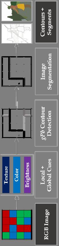
19 Automate Globalized Probability of Boundary (gpb) Contour Detection


20 Automate Simple Linear Iterative Clustering (SLIC)
 Results: Compared to manual delineation, the number of clicks per 100m is reduced up")
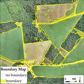
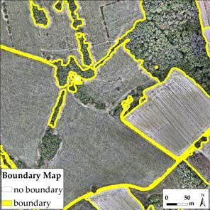
21 Automate Combination of: The two state-of-the-art computer vision methods: gpb and SLIC and Machine learning part (assigning costs to each outline according to local boundary knowledge) Interactive user guided delineation (by calculating the least cost path by previeously extracted lines) Results: Compared to manual delineation, the number of clicks per 100m is reduced up to 86%
22 Tool integration HL- To develop a technical platform for integrating the developed tools. The implementation follows a toolbox approach user can select the tools of his interest. Following the idea for geocloud the tools will be encapsulated as services with an appropriate API.
23 Govern and Grow and Capitalize To understand how these technologies can be adopted and sustained To develop a sustainable business model for commercialization of the integrated suite of land tenure recording tools within the enduser markets.
24 Website


25 Smart Surveyors for Land and Water Management
The Intelligent Cadastre
 The Intelligent Cadastre Rohan Bennett, Kwabena Asiama, and Jaap Zevenbergen FIG Commission 7/3 Workshop on Crowdsourcing of Land Information St Juliens, Malta 16-20 November 2015 What is intelligent?
Implementing Innovative Land Tenure Tools In East-Africa: SWOT-Analysis Of Land Governance
 Presented at the FIG Working Week 2017, May 29 - June 2, 2017 in Helsinki, Finland Implementing Innovative Land Tenure Tools In East-Africa: SWOT-Analysis Of Land Governance Ine BUNTINX, Joep CROMPVOETS,
Deliverable 2.2 Stakeholder audit and classification
 Deliverable 2.2 Stakeholder audit and classification 29 th April 2016 Version 1.4 Abstract: An audit of its4land stakeholders including actors classification and identification and selected use case areas
MASS REGISTRATION OF LAND PARCELS USING FIT-FOR-PURPOSE LAND ADMINISTRATION: PROCEDURES AND METHODS
 MASS REGISTRATION OF LAND PARCELS USING FIT-FOR-PURPOSE LAND ADMINISTRATION: PROCEDURES AND METHODS TAREK ZEIN Hansa Luftbild AG, Germany zein@hansaluftbild.de Paper prepared for presentation at the 2017
International funding projects in Republic Geodetic Authority
 International funding projects in Republic Geodetic Authority Serbia: Republic Geodetic Authority Workshop Exploring Funding Instruments for NMCA 7-8 November 2012 Republic Geodetic Authority Republic
Responsible and Innovative Land Administration
 Responsible and Innovative Land Administration An Example from Ethiopia 3 RD DECEMBER 2018 Outline A few words about NIRAS Fit-for-purpose: A low-tech disruptive approach? The REILA Project in Ethiopia
Egyptian Nationwide Title Cadastre System
 Kholoud SAAD, Egypt Key words: Cadastre, Registration, Urban, Rural, National Cadastre, Automation, reengineering. SUMMARY With growing need for integrated information, Enterprise Solutions has become
Meeting the Changing National Geospatial Information Needs. Palitha Udayakantha Surveyor General - Sri Lanka
 Meeting the Changing National Geospatial Information Needs Palitha Udayakantha Surveyor General - Sri Lanka Sri Lanka Location Latitude 5 55 10-9 50 6 North Longitude 79 31 19-81 52 36 East Area 65610
UN-HABITAT s Mission and Vision. Sustainable urban development Adequate shelter for all
 GLTN contributes to the implementation of pro poor land policies to achieve secure land rights for all www.gltn.net GLTN Secretariat, facilitated by PO Box 30030, Nairobi 00100, Kenya Tel: +254 20 762
The Developing Role of the Surveyor in a Developing World
 The Developing Role of the Surveyor in a Developing World Paula DIJKSTRA 24-9-2018 FIG Seminar Cadastre in a digital world Nordic and Global Perspective Developing World requires reliable geospatial information
Map Modernization Modernization Program
 FEMA Map Modernization Program Presented to Maryland Association of Floodplain and Stormwater Managers October 27, 2005 Map Modernization Program Autorun.exe 2 Map Modernization Program Outline Map Mod
LOW-COST LAND INFORMATION SYSTEM FOR SUSTAINABLE URBAN DEVELOPMENT
 Presented at the FIG Congress 2018, May 6-11, 2018 in Istanbul, Turkey LOW-COST LAND INFORMATION SYSTEM FOR SUSTAINABLE URBAN DEVELOPMENT Case Examples in Kenya and Zambia Presented by John Gitau Land
Click to edit Master title style
 Click to edit Master title style Modern Cadastre and Land Administration Session 5a. The toolbox approach Jude Wallace 2007 Click to edit Overview Master title style Objectives To understand the circumstances
Securing Land Rights for Broadband Land Acquisition for Utilities in Sweden
 Securing Land Rights for Broadband Land Acquisition for Utilities in Sweden Marija JURIC and Kristin LAND, Sweden Key words: broadband, land acquisition, cadastral procedure, Sweden SUMMARY The European
AN OVERVIEW OF LAND TOOLS IN SUB- SAHARAN AFRICA: PAST, PRESENT AND FUTURE
 AN OVERVIEW OF LAND TOOLS IN SUB- SAHARAN AFRICA: PAST, PRESENT AND FUTURE BY CLARISSA AUGUSTINUS CHIEF, LAND AND TENURE SECTION UNHABITAT Nairobi, 11-11-2004 WHY UN-HABITAT HAS CO-SPONSORED THIS EGM UN-HABITAT
Innovations in Education at Faculty ITC and within Land Administration Programme
 Innovations in Education at Faculty ITC and within Land Administration Programme Prof. Jaap Zevenbergen, Vice-Dean Education at Faculty ITC, Prof. Land Administration dr. Dimo Todorovski, Course Coordinator
Infrastructure challenges & geospatial solutions
 Infrastructure challenges & geospatial solutions Geospatial World Forum, Amsterdam 2012 Exchange Forum on Earth Observation Systems for Nation Building Todd Douglas Taylor, Trimble Social harmony Connection
Technology-driven solutions for the innovation of land administration and management
 Technology-driven solutions for the innovation of land administration and management Technology and economic growth - Studies*find link between technology innovation and national economic prosperity especially,
CONCEPT NOTE EFFECTIVE LAND ADMINISTRATION IN AFRICA TRAINING WORKSHOP
 CONCEPT NOTE EFFECTIVE LAND ADMINISTRATION IN AFRICA TRAINING WORKSHOP Innovative Concepts, Tools and Practices for Effective Land Administration Land Conference Pre-Conference Workshop Advocating & Implementing
The New Technology of a Survey Data Model and Cadastral Fabric as the Foundation for a Future Land Administration System.
 The New Technology of a Survey Data Model and Cadastral Fabric as the Foundation for a Future Land Ian HARPER, Australia Key words: cadastral modelling, survey data model, Survey Accuracy, Cadastre 2014
Mass Housing Development Blueprint: The Case of Namibia
 Mass Housing Development Blueprint: The Case of Namibia Charl-Thom Bayer Department of Land and Property Sciences Governance in Africa 15-17 1. How is Policy Informed Nationally and Regionally? 2. How
Esri Middle East and Africa User Conference. December Abu Dhabi, UAE. Land Administration. Mark Baker
 Esri Middle East and Africa User Conference December 10 12 Abu Dhabi, UAE Land Administration Mark Baker Our Agenda 0900 0930 Welcome Mark Baker, Esri 0930 1030 New Directions The New Addressing System
ParcelMap BC Compiling a Parcel Fabric for the Province of British Columbia. Presented by: Ellen Styner (General Manager) and Wendy Amy (GIS Manager)
 and Wendy Amy (GIS Manager)") ParcelMap BC Compiling a Parcel Fabric for the Province of British Columbia Presented by: Ellen Styner (General Manager) and Wendy Amy (GIS Manager) Who is MNC? MNC is a geomatics engineering firm with
ParcelMap BC Compiling a Parcel Fabric for the Province of British Columbia Presented by: Ellen Styner (General Manager) and Wendy Amy (GIS Manager) Who is MNC? MNC is a geomatics engineering firm with
A Quantitative Comparison of Completely Visible Cadastral Parcels Using Satellite Images: A Step towards Automation
 A Quantitative Comparison of Completely Visible Cadastral Parcels Using Satellite Images: A Step towards Automation Divyani KOHLI, Netherlands, Rohan BENNETT, Australia, Christiaan LEMMEN, Kwabena ASIAMA,
A Vision for a Fully Digital Cadastral Survey System
 A Vision for a Fully Digital Cadastral Survey System Anselm HAANEN, Trent GULLIVER, New Zealand Key words: cadastral survey system, digital cadastre, survey plans SUMMARY Surveyors have traditionally prepared
Low Cost Cadastral Data Aquisition?
 Low Cost Cadastral Data Aquisition? Jacobus Meijer and Christiaan Lemmen (Netherlands): 21 May 2011 Abstract Spatial Cadastral Data (Mapping) Participatory Development Some low cost approaches in cadastral
Advances in Modern Land Administration Cadastre 2014 in the Year 2006
 Advances in Modern Land Administration Cadastre 2014 in the Year 2006 Winfried HAWERK, Germany Key words: E-Land Administration, IT renewal strategies SUMMARY FIG Commission 7 Working Group 7.3 deals with
Digitalisation of the Real Property Rights Towards Spatially enabled E-Government
 Digitalisation of the Real Property Rights Towards Spatially enabled E-Government Lise Schroeder, Bent Hulegaard Jensen, Esben Munk Soerensen & Line Hvingel Istanbul, Turkey 25 june 201 Overview Introduction
NELGA GOOD PRACTICES. Training Workshop on Effective Land Administration in Africa
 Training Workshop on Effective Land Administration in Africa Training workshop on effective land administration in Africa A training workshop on effective land administration in Africa was held at United
The Fit- for-purpose Concept
 The Fit- for-purpose Concept Building Spatial Frameworks for Sustainable Land Governance in Sub-Sahara Africa Prof. Stig Enemark Honorary President Aalborg University, Denmark LAND POLICIES AND LAND GOVERNANCE,
Cadastre in Addis Ababa. Status and future development
 Status and future development Dr.-Ing. Paul Hartfiel Mülheim, 1. Oct. 2010-1 - Addis Ababa Capital of Ethiopia Area population 540 km² > 3,200,000 (rapidly growing) 2,300,000 in 1994 > 22% of all urban
Land Information System as new instrument for Land Administration: Case Examples. Mike Cheremshynskyi Consultant, Land Administration Expert
 Land Information System as new instrument for Land Administration: Case Examples Mike Cheremshynskyi Consultant, Land Administration Expert Background Growth of population and fast urbanization in many
Implementing Innovative Land Tenure Tools In East-Africa: SWOT-Analysis Of Land Governance
 Implementing Innovative Land Tenure Tools In East-Africa: SWOT-Analysis Of Land Governance Ine BUNTINX, Joep CROMPVOETS, Serene HO, Bruno BROUCKER, Belgium Key words: Land Governance, Land Tenure SUMMARY
Centre for SDIs and Land Administration Department of Geomatics Spatial systems to support sustainable development
 Centre for SDIs and Land Administration Department of Geomatics MODERN CADASTER and LAND ADMINISTRATION تهران-مرداد 1386 2014 ..... 2 ماه Centre for SDIs and Land Administration Department of Geomatics
Good Land Governance for the 2030 Agenda
 Good Land Governance for the 2030 Agenda Addis Ababa, Ethiopia 20-22 April, 2014 Role of Geospatial Information in Good Land Policy and Governance Oumar Sylla UN-Habitat/GLTN oumar.sylla@unhabitat.org
PROCESSES IN CADASTRE: PROCESS MODEL FOR SERBIAN 3D CADASTRE
 UNIVERSITY IN NOVI SAD, SERBIA FACULTY OF TECHNICAL SCIENCES PROCESSES IN CADASTRE: PROCESS MODEL FOR SERBIAN 3D CADASTRE Dubravka SLADIĆ, Aleksandra RADULOVIĆ and Miro GOVEDARICA 6th International FIG
PREPARING SURVEY TENDER GIS DATABASE OUTCOMES
 PREPARING SURVEY TENDER SPECIFICATIONS FOR PROJECT GIS DATABASE OUTCOMES Presentation by Ian Harper GEODATA AUSTRALIA ESRI User Conference 2009 24 st July 2009 BACKGROUND GIS databases now provide a more
Fit-for Purpose Approaches to Land Administration
 Fit-for Purpose Approaches to Land Administration Brent Jones, PE, PLS Global Manager, Casastre/Land Records bjones@esri.com Land Administration GIS is the platform for land administration Land administration
COMPUTERIZED SYSTEM SUPPORTING DEVELOPMENT OF LAND MARKET IN GEORGIA
 COMPUTERIZED SYSTEM SUPPORTING DEVELOPMENT OF LAND MARKET IN GEORGIA S. G. TSIRAMUA, I. S. MELASHVILI Land Registration Unit of Government of Georgian, World Bank and IFAD Agriculture Development Project.
CADASTRE 2014: New Challenges and Direction
 CADASTRE 2014: New Challenges and Direction Anna KRELLE and Abbas RAJABIFARD, Australia Key words: Cadastre, Cadastre 2014, Land Administration SUMMARY Land and land related activities form part of the
A new era: Dynamic Information Management
 A new era: Dynamic Information Management Professional and Institutional Developments Kees de Zeeuw MSc Director Kadaster International The Netherlands Affiliate member s perspective 45 affiliates from
A CADASTRAL GEODATA BASE FOR LAND ADMINISTRATION USING ARCGIS CADASTRAL FABRIC MODEL A CASE STUDY OF UWANI ENUGU, ENUGU STATE, NIGERIA
 A CADASTRAL GEODATA BASE FOR LAND ADMINISTRATION USING ARCGIS CADASTRAL FABRIC MODEL A CASE STUDY OF UWANI ENUGU, ENUGU STATE, NIGERIA BY Ndukwu, Raphael. Ike Department of Geoinformatics & Surveying University
Low Cost Titling in Africa
 Low Cost Titling in Africa Land Tenure Regularisation in Rwanda Presentation to the World Bank Annual Land Conference, Washington DC April 26-27, 2010 National Land Centre, Ministry of Environment and
GLTN Tools and Approaches in Support of Land Policy Implementation in Africa
 GLTN Tools and Approaches in Support of Land Policy Implementation in Africa Jamal Browne (UN-Habitat), Jaap Zevenbergen (ITC), Danilo Antonio (UN-Habitat), Solomon Haile (UN-Habitat) Land Policy Development
Key Concepts, Approaches and Tools for Strengthening Land Tenure Security
 Key Concepts, Approaches and Tools for Strengthening Land Tenure Security Dr. Samuel Mabikke Land & GLTN Unit / UN-Habitat Urban CSO Cluster Learning Exchange on Strengthening Land Tenure Security for
Project Management Forum. Eilat 2009
 Project Management Forum Eilat 2009 May 2009 FIG Working Week 1 Purpose To build on the sessions in Hong Kong and Stockholm To review the elements of PM To review examples of the stages of development
Land Administration Developments in Rwanda
 Land Administration Developments in Rwanda Eugène RURANGWA Expert Group Meeting on secure land tenure new legal frameworks and tools UN-Gigiri, Nairobi, 10-12 November, 2004 Contents Somme figures about
GLTN LAND TOOLS -SOME EXAMPLES-
 GLTN LAND TOOLS -SOME EXAMPLES- Dr. Jaap Zevenbergen University of Twente What are GLTN Land Tools? GLTN considers that a tool is a practical method to achieve a defined objective in a particular context.
By: Barney I. S. Laseko Programme Coordinator Prime Minister s Office TANZANIA
 2014 CONFERENCE ON LAND POLICY IN AFRICA 11 14 NOVEMBER, 2014 Focussed Discussion VIII Converting from Manual Land Registration to GIS Enabled Land Information System Case of Sub Saharan Africa Tanzania
GAUSSCAD A WEBGIS APPLICATION FOR COLLECTING CADASTRAL DATA
 M.M. Moise GaussCAD a WebGIS Application for Collecting Cadastral Data GAUSSCAD A WEBGIS APPLICATION FOR COLLECTING CADASTRAL DATA Mihai-Mircea MOISE, S.C. GAUSS S.R.L., mihai.moise@gauss.ro Abstract:
Fit-For-Purpose Land Administration: Guiding Principles FACILITATED BY:
 Fit-For-Purpose Land Administration: Guiding Principles 1. GLTN overview - GLTN BRIEFING AND PROGRAMME 2. Geospatial Data - Sustainable Development - 3. Fit-for-purpose Land Administration Guiding Principles
A Geocoded Cadastral Fabric as a Precondition for a Sustainable Land Management System
 A Geocoded Fabric as a Precondition for a Sustainable Land Management System Gottfried KONECNY, Germany; J.P. LAUZON, Canada; Abdul Salam MOHAMMED, India Key words: SDI,, Parcel Boundaries, GPS-GNSS, Land
Marine Spatial Data Infrastructure (MSDI) & The Marine Cadastre Application. April 10, 2018
 & The Marine Cadastre Application. April 10, 2018") Marine Spatial Data Infrastructure (MSDI) & The Marine Cadastre Application April 10, 2018 A Collaborative Pilot Project Vision of CHS: A framework of geographic data, metadata, users and tools Intent
Marine Spatial Data Infrastructure (MSDI) & The Marine Cadastre Application April 10, 2018 A Collaborative Pilot Project Vision of CHS: A framework of geographic data, metadata, users and tools Intent
UN-GGIM Expert Group on Land Administration and Management Expert Group Meeting, Delft, The Netherlands 14 & 15 March, 2017
 UN-GGIM Expert Group on Land Administration and Management Expert Group Meeting, Delft, The Netherlands 14 & 15 March, 2017 BACKGROUND DOCUMENT The Delft Expert Group Meeting This two-day meeting of the
Spatial Data Warehouse Ltd. Cadastral Mapping INITIATIVE 1: CADASTRAL MAPPING. Version Spatial Data Warehouse Ltd. & AltaLIS Ltd.
 Spatial Data Warehouse Ltd. Initiative 1: Cadastral Mapping INITIATIVE 1: CADASTRAL MAPPING 29 P3 The SDW/AltaLIS Model Background The Government of Alberta started a mapping program, the Municipal Integrated
Land Tools for Tenure Security for All
 Land Tools for Tenure Security for All PROF. JAAP ZEVENBERGEN UNIVERSITY OF TWENTE - ITC 1 ST JUNE 2017 HELSINKI, FINLAND GLOBAL LAND CHALLENGES 70 % Dealing with the affordability issue - how to modernize
Land Markets and Land Rights in support of the Millennium Development Goals
 Land Markets and Land Rights in support of the Millennium Development Goals A Global Perspective Prof. Stig Enemark President Aalborg University, Denmark 3rd LAND ADMINISTRATION FORUM FOR THE ASIA AND
Royal Institute of British Architects. Report of the RIBA visiting board to Coventry University
 Royal Institute of British Architects Report of the RIBA visiting board to Coventry University Date of visiting board: 22 & 23 November 2018 Confirmed by RIBA Education Committee: 19 February 2019 1 Details
EXPLORING OPTIONS FOR STANDARDISATION OF PROCESSES AND TRANSACTIONS IN LAND ADMINISTRATION
 EXPLORING OPTIONS FOR STANDARDISATION OF PROCESSES AND TRANSACTIONS IN LAND ADMINISTRATION CHRISTIAAN LEMMEN (1),(2), EVA-MARIA UNGER (2), PETER VAN OOSTEROM (3), MOHSEN KALANTARI (4) AND KEES DE ZEEUW
The Journey to 100% Electronic Survey. Land Information New Zealand. August 2009
 The Journey to 100% Electronic Survey and Title Lodgement Land Information New Zealand August 2009 Land Information New Zealand Established 1996 Titles, Survey, Geodetic, Electoral 12 locations 500 staff
Global Eradication of Infectious Diseases
 Global Security of Tenure Campaign the Time of Rights Dr Robin McLaren Land Professional Know Edge Limited Location Information Innovation COMMISSION 7 ANNUAL MEETING, COIMBRA, PORTUGAL OCTOBER 2016 1
Integration of Public Service Procedures and Use of Cadastral Data
 Integration of Public Service Procedures and Use of Cadastral Data Signe Rudzite Head of Cadastre and Register Department The State Land Service Vilnius, 21.10.2013 Content General information Current
Alternatives for Economic Boundary Determination in the Establishment of a Cadastral System. Paper to the FIG Working Week 2012 Rome, May 9, 2012
 Alternatives for Economic Boundary Determination in the Establishment of a Cadastral System Paper to the FIG Working Week 2012 Rome, May 9, 2012 by Gottfried Konecny Emeritus Professor Leibniz University
Making housing finance markets work for the poor A perspective on the role of big data. Illana Melzer
 Making housing finance markets work for the poor A perspective on the role of big data Illana Melzer Illana@71point4.com 2 Big data is generated everywhere. How much of it is justifiably in the line of
LAND TENURE IN ASIA AND THE PACIFIC CHALLENGES, OPPORTUNITIES AND WAY FORWARD
 LAND TENURE IN ASIA AND THE PACIFIC CHALLENGES, OPPORTUNITIES AND WAY FORWARD Workshop on Land Administration and Management 20th United Nations Regional Cartographic Conference for Asia and the Pacific
LAND ADMINISTRATION ACADEMIC EDUCATION IN EASTERN AFRICA. Eastern Africa Land Administration Academic Network EALAAN
 LAND ADMINISTRATION ACADEMIC EDUCATION IN EASTERN AFRICA Eastern Africa Land Administration Academic Network EALAAN AUTHORS OF THE PAPER Fabien HAGENIMANA, Rwanda Seid HUSSEN, Ethiopia Monica LENGOIBONI,
Functional system for cadastral plans
 , Republic of Macedonia Key words: Cadastre, Digital plans, Data, System SUMMARY The analysis shows that the real estate market in Republic of Macedonia grows daily. With the expansion of this market increases
Lessons for federated countries that have state land registries the Australian experience
 Lessons for federated countries that have state land registries the Australian experience Ian Williamson Centre for SDI and Land Administration Department Infrastructure Engineering University of Melbourne
Rohan Bennett (PhD) Jaap Zevenbergen (Prof.)
 Jaap Zevenbergen (Prof.)") Developing an integrated conceptual model to understand land governance continuum Berhanu K. Alemie (PhD) Rohan Bennett (PhD) Jaap Zevenbergen (Prof.) Presentation outline Background Research objective
Developing an integrated conceptual model to understand land governance continuum Berhanu K. Alemie (PhD) Rohan Bennett (PhD) Jaap Zevenbergen (Prof.) Presentation outline Background Research objective
Cadastre a role model for Private-Public-People-Partnership
 Cadastre 4.0 - a role model for Private-Public-People-Partnership Gerda Schennach, Austria Chair of FIG Commission 7 1 Who owns... buildings? the mountains? land? forests? the sea? infrastructure? 2 From
Building Fit for Purpose Land Administration Systems - World Bank Experience
 Building Fit for Purpose Land Administration Systems - World Bank Experience Gavin Adlington Lead Land Administration Specialist The World Bank Fit For Purpose The only way to establish a successful land
Introduction to Land Tenure Administration
 Introduction to Land Tenure Administration Karol Boudreaux Land Tenure & Resource Rights Practice Lead, The Cloudburst Group January 22, 2018 January 22, 2018 1 WHAT WE LL COVER Background and Definitions
Information Quality - A Critical Success Factor How to make it all right!
 Information Quality - A Critical Success Factor How to make it all right! Anders Svensson, Sweden Key words: Cadastre, information quality, property information, property boundaries SUMMARY Sweden has
Mobile and Tablet. Ready
 Realtors are demanding newer and more accurate solutions to assist them in client communications. These solutions need to be able to deliver accurate property information both in and outside the office.
The LADM and the Continuum of Land Rights
 CheeHai TEO, Malaysia and Christiaan Lemmen, the Netherlands Key words: LADM, Continuum of Land Rights, Voluntary Guidelines, Spatial Enabled Societies SUMMARY The development of the Land Administration
Economic and Social Council 6 July 2018
 1 ADVANCE UNEDITED VERSION UNITED NATIONS E/C.20/2018/12/Add.1 Economic and Social Council 6 July 2018 Committee of Experts on Global Geospatial Information Management Eighth session New York, 1-3 August
The Social Tenure Domain Model STDM-Online
 Land and Poverty Conference 2016 Scaling up Responsible Land Governance 14-18 March, 2016 Washington, DC The Social Tenure Domain Model STDM-Online Arnulf Christl: metaspatial Cyprian Celebalo: UN Habitat
Land Information System for Revenue Planning, Estimates and Collection
 Land Information System for Revenue Planning, Estimates and Collection Hardi FADILLAH HAMZAH, Malaysia Key words: valuation, land revenues SUMMARY With the emerging trend of State Government implementing
Problems and Solution Proposals in Integration of Cadastral Data into Geographical Information System (GIS) in Turkey
 in Turkey") Problems and Solution Proposals in Integration of Cadastral Data into Geographical Information System (GIS) in Turkey Gülgün OZKAN, S. Savas DURDURAN, Ali ERDI and Bilal GIRGIN, Turkey Key words: Cadastre,
Problems and Solution Proposals in Integration of Cadastral Data into Geographical Information System (GIS) in Turkey Gülgün OZKAN, S. Savas DURDURAN, Ali ERDI and Bilal GIRGIN, Turkey Key words: Cadastre,
New Models for Property Data Verification and Valuation
 New Models for Property Data Verification and Valuation for 2006 IAAO Councils and Sections Joint Seminar May 9-11, 2006 Charleston, South Carolina Presented by George Donatello, CMS Principal Consultant
The programme is implemented
 Surveying Property valuation and spatial data tools to assist in land restitution by Jaco de Kock, GISCOE Land and tenure reform in the South African government context are beyond talk and have received
Unified Land Administration for a Better Spatial Infrastructure
 Unified Land Administration for a Better Spatial Infrastructure Gyula IVÁN Institute of Geodesy, Cartography & Remote Sensing FÖMI (HUNGARY) Open Symposium 30th Korean Cadastral Seminar & FIG Commission
LAND ISSUES AND GEO-INFORMATION: RESPONDING POST DISASTER EARTHQUAKES IN NEPAL
 LAND ISSUES AND GEO-INFORMATION: RESPONDING POST DISASTER EARTHQUAKES IN NEPAL ARBIND MAN TULADHAR FACULTY OF GEO-INFORMATION SCIENCE AND EARTH OBSERVATION (ITC), UNIVERSITY OF TWENTE, THE NETHERLANDS,
Land surveying is probably the (second) oldest profession in the world
 oldest profession in the world") Land Surveying and Land Management in an International Perspective Prof Stig Enemark Honorary President Aalborg University, Denmark CADASTRE IN A DIGITAL WORLD NORDIC AND GLOBAL PRESPECTIVES INTERNATIONAL
Land Surveying and Land Management in an International Perspective Prof Stig Enemark Honorary President Aalborg University, Denmark CADASTRE IN A DIGITAL WORLD NORDIC AND GLOBAL PRESPECTIVES INTERNATIONAL
Presented by: Stewart Information International, Inc. Jack McKenna
 Presented by: Stewart Information International, Inc. Jack McKenna Held at the: 2007 ESRI Survey & Engineering GIS Summit San Diego Convention Center San Diego, California June 16-19, 2007 Integrating
2016 CIAM PLENARY MEETING. Item 13 - Open Forum Drones Activities Development by CIAM
 1 2016 CIAM PLENARY MEETING Item 13 - Open Forum Drones Activities Development by CIAM CIAM Organising Committee for FAI International Events for Drones Terms of Reference: published in July 2015 Mission
Towards Kenya s Profile of the Land Administration Domain Model
 Department of Geospatial and Space Technology University of Nairobi Towards Kenya s Profile of the Land Administration Domain Model David N. Siriba and Jasper N. Mwenda dnsiriba, jnmwenda{@uonbi.ac.ke}
Role of spatial planning in modern society
 Republic of Croatia State Geodetic Administration The Role of Cadastre in the Development of Regional and Local Planning Structure in Croatia Zdravko Cesarec and Željko Bačić 1 Role of spatial planning
THE APPLICATION OF GIS AND LIS Solutions and Experiences in East Africa. Lenny Kivuti
 Using GIS and LIS for Planning Sustainable Development Bepic Group CHOGM, Malta 2005 THE APPLICATION OF GIS AND LIS Solutions and Experiences in East Africa Lenny Kivuti 21 November, 2005 Presented by
The Digital Cadastral Database and the Role of the Private Licensed Surveyors in Denmark
 IRISH INSTITUTE OF SURVEYORS, DUBLIN INSTITUTE OF TECHNOLOGY, 23 NOVEMBER 2005 PUBLISHED IN IIS NEWS, WINTHER 2006. The Digital Cadastral Database and the Role of the Private Licensed Surveyors in Denmark
Engaging the Land Sector Gatekeepers in Crowd sourced Land Administration
 Engaging the Land Sector Gatekeepers in Crowd sourced Land Administration Robin MCLAREN, United Kingdom Key words: citizen empowerment, crowdsourcing, land administration, pilot projects, gate keepers,
GPS For Land Surveyors By Jan Van Sickle
 GPS For Land Surveyors By Jan Van Sickle You might be aware that surveyors have been using GPS to do extremely precise surveys for years, fixing points with relative accuracy on the order of millimeters.
LAND ADMINISTRATION DEVELOPMENTS IN RWANDA
 LAND ADMINISTRATION DEVELOPMENTS IN RWANDA, Rwanda Key words : Land tenure security, land registration, land rights, land commissions. SUMMARY : The new Rwandan land policy consider appropriate land administration
Providing access to land: challenges and solutions Lessons learnt by members of the International Land Coalition
 Providing access to land: challenges and solutions Lessons learnt by members of the International Land Coalition CSD17 Capacity Building Workshop Bangkok, 28-30 January 2009 Dr Michael Taylor, Programme
Presented at the FIG Congress 2018, May 6-11, 2018 in Istanbul, Turkey
 Presented at the FIG Congress 2018, May 6-11, 2018 in Istanbul, Turkey 5 Bibliometric Analysis of Articles Presented Under Commission 7: A Case of the 25th Fig Congress in Malaysia in 2014 Zeynel Abidin
IT-SUPPORTED STATE-LAND MANAGEMENT IN A TRANSITIONAL ENVIRONMENT
 IT-SUPPORTED STATE-LAND MANAGEMENT IN A TRANSITIONAL ENVIRONMENT - Examples from Eastern Germany and Mongolia - TOPICS 1 S LAND INFORMATION SYSTEM History and main components IT-strategy and development
The Boundary and the Effects of Cadastral Surveying in Cyprus
 The Boundary and the Effects of Cadastral Surveying in Cyprus Aristi Louca, Margarita Fani Surveyor Engineers, Cyprus Association of Rural and Surveying Engineers The History of Cyprus goes back 11000
THE XXV FIG INTERNATIONAL CONGRESS IN MALAYSIA Kuala Lumpur, Malaysia, June 2014 at Kuala Lumpur Convention Centre
 CALL FOR PAPERS TO THE XXV FIG INTERNATIONAL CONGRESS IN MALAYSIA Kuala Lumpur, Malaysia, 16 21 June 2014 at Kuala Lumpur Convention Centre Dear Friend and Colleague, It is our privilege and honour to
Cloud GIS Real Estate Management, Appraisal and Development Service USING ESRIs ARCGIS SERVER
 Cloud GIS Real Estate Management, Appraisal and Development Service USING ESRIs ARCGIS SERVER INFODIM: Was founded on 1992 and is internationally certified as a GIS company from D&B Dun & Bradstreet Global
The development of a GIS for an informal settlement. Benita NORDIN, Swedesurvey AB
 Benita NORDIN, Swedesurvey AB Key words: GIS, informal settlement, land tenure, adjudication SUMMARY The purpose of the paper is to try to show examples of the use of GIS as one of the tools for solving