From Measurement to Management
|
|
|
- Molly Ford
- 5 years ago
- Views:
Transcription

1 From Measurement to Management The changing role of the land surveyors Prof. Stig Enemark Aalborg University, Denmark LAND MANAGEMENT AND HUMAN RIGHTS INTERNATIONAL SEMINAR, HØGSKOLEN I BERGEN, 8 9 SEPTEMBER 2014


2 The enclosure movement in DK The enclose movement included a transformation from a feudalistic to a market oriented society based on private ownership to land. The resulting structure of agriculture holdings can be found in today s cadastral and topographic maps.
3 Technology Engineer Law Lawyer Planning Architect Real Property Measurement Science Spatial Information Management Land Management Surveyor Mapping GIS-systems Land-use Management Consultancy Engineering Surveys Cadastral Work Spatial Planning
4 Private licensed surveyors Liberal profession (such as lawyers, veterinarians, etc.) Licensed for boundary determination and cadastral work (40%) Work areas also include: Mapping, engineering surveys, GIS (40%) Consultancy on real estate and land law issues (15%) About 400 surveyors working in private practice About 100 private surveying firms (2012) throughout the country of 5.5. mill inhabitants.

5 The only constant is change

6 Evolution of the Surveying Profession in DK State agencies 15% Municipalities 25% Engineering companies 15% Total 60% 15% 25% Private practice total 40%

7 Evolution of the Professional Profile in DK
8 The big swing From Measurement Surveyors will still be high level experts within measurement science, but due to technology development the role is changing into managing the measurements To Management Surveyors will increasingly contribute to building sustainable societies as experts in managing land and properties The Land Professionals


9 Setting the scene The people to land relationship is dynamic and reflects the cultural and institutional setting of the country or jurisdiction


10 Evolution of the land administration discipline Tomb of Menna, Ancient Egypt, ca BCE Evolution of Western Land Administration Systems


11 Cadastral systems FIG, 1996 UN-ECE, 1996 The concept of the multipurpose cadastre FIG, 1999

12 Land Registration Systems around the World Deeds System (French/Latin/USA style): A register of owners; the transaction is recorded not the title. Title System (German, Torrens/English style): A register of properties; the title is recorded and guarantied.

13 A Worldwide Comparison of Cadastral Systems

14 A Global Perspective 14


15 Land Reform Eastern Europe Romania fragmented agricultural parcels Denmark (same scale) - consolidated agricultural holdings 15
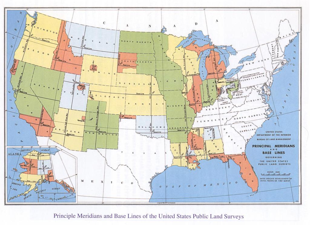
16 U.S.A. 16
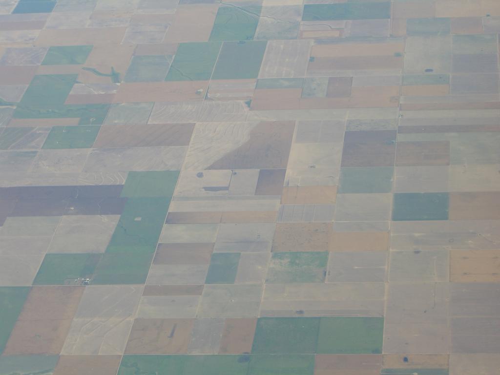
17 17

18 U.S.A. Mount Rushmore, South Dakota Three surveyors and some other guy George Washington, Thomas Jefferson, Theodor Roosevelt, Abraham Lincoln 18

19 A cadastral map of Australia One map - 10,2 mill parcels


20 Countries in Transition - China 20


21 Africa - limitations of formal cadastral systems More than 70 per cent of the land in many developing countries are outside the formal systems of land registration and administration This relates especially to informal settlements and areas governed by customary tenure Traditional cadastral systems do not provide for security of tenure in these areas. Traditional cadastral surveys are too costly and time consuming for dealing with informal land rights
: Not only a (legal) person but a range of subjects such as")
 parcel but a range of objects such as land parcels, land objects, buildings, etc.")

22 The Social Tenure Domain Model Party Social Tenure Relationship Spatial Unit Modeling the relation between Parties Social Tenure Spatial Unit Parties (who): Not only a (legal) person but a range of subjects such as person, couple, groups of people, unidentified groups, authority Spatial Unit (where): Not only an identified (measured) parcel but a range of objects such as land parcels, land objects, buildings, etc., and identified in various ways such as a point, street -axes, photos Social tenure (what): Not only ownership and formal legal rights but also a range of informal, indigenous and customary rights as well as financial issues such group loans and micro credit.


23 Fit-for purpose Most developed countries have developed a country-wide spatial framework over centuries mainly as large scale cadastral maps. In most developing countries the cadastral coverage is less than 30 per cent and serving only the elite. A country wide spatial framework should be developed using a fit-forpurpose approach rather than being guided by high tech solutions and costly/time consuming field survey procedures. A continuum of land rights, a continuum of accuracy, a continuum registration, a continuum of..

24 Fit-for purpose Key principles General boundaries rather than fixed boundaries - General boundaries will be sufficient for most land administration purposes.. Aerial imageries rather than field surveys. - Aerial imageries are 3-5 times cheaper and less capacity demanding than field surveys. - Aerial imageries provide not only the framework of the parcels but also the general topography to be used for a range of land administration functions Accuracy relates to the purpose rather than technical standards - Accuracy should be seen as a relative term related to the use of the information Opportunities for updating, upgrading and improvement - Building the spatial framework is not a one stop process - In turn, incremental improvement will establish a fully integrated land administration system. - This could be named as a Continuum of Accuracy

25 From Cadastre to Land Governance Holding of rights to lands Economic aspects of land Control of land use and land development Administering the people to land relationship through Land Policy Land Management Good Governance and Building the capacity to deal with this

26 Land governance Land governance is about the policies, processes and institutions by which land, property and natural resources are managed. This includes decisions on access to land; land rights; land use; land development. Land governance is about determining & implementing sustainable land policies. The land management paradigm

 All land and")
27 Spatially Enabled Government A spatially enabled government organises its business and processes around place based technologies. It is not about managing spatial information it is about managing information, or governing society, spatially. The technical core of Spatially Enabled Government is the spatial framework (land parcel mapping) All land and all kind of tenure rights and land use must be included in the land administration systems
28 Key message Simply put sustainable development requires sustainable land administration systems Land professionals play a key role in building and managing these systems Thank you for your attention
A beautiful setting. The Evolving Role of Cadastral Systems in Support of Good Land Governance. Setting the scene
 The Evolving Role of Cadastral Systems in Support of Good Land Governance Prof. Stig Enemark President Aalborg University, Denmark THE DIGITAL CADASTRAL MAP FIG COMMISSION 7 OPEN SYMPOSIUM KARLOVY VARY,
Land surveying is probably the (second) oldest profession in the world
 oldest profession in the world") Land Surveying and Land Management in an International Perspective Prof Stig Enemark Honorary President Aalborg University, Denmark CADASTRE IN A DIGITAL WORLD NORDIC AND GLOBAL PRESPECTIVES INTERNATIONAL
Land Surveying and Land Management in an International Perspective Prof Stig Enemark Honorary President Aalborg University, Denmark CADASTRE IN A DIGITAL WORLD NORDIC AND GLOBAL PRESPECTIVES INTERNATIONAL
The Fit- for-purpose Concept
 The Fit- for-purpose Concept Building Spatial Frameworks for Sustainable Land Governance in Sub-Sahara Africa Prof. Stig Enemark Honorary President Aalborg University, Denmark LAND POLICIES AND LAND GOVERNANCE,
Scenic Nepal. Land Administration Systems. Outline of Presentation. Interests in land. Rights: Registration and security of tenure positions
 Scenic Nepal Land Administration Systems Managing Rights, Restrictions, and Responsibilities in Land Prof. Stig Enemark President Aalborg University, Denmark SURVEY DEPARTMENT KATHMANDU, NEPAL. 16 FEBRUARY
Land Markets and Land Rights in support of the Millennium Development Goals
 Land Markets and Land Rights in support of the Millennium Development Goals A Global Perspective Prof. Stig Enemark President Aalborg University, Denmark 3rd LAND ADMINISTRATION FORUM FOR THE ASIA AND
Greetings from Denmark. Property Rights, Restrictions and Responsibilities - A Global Land Management Perspective. Wonderful Copenhagen
 Property Rights, Restrictions and Responsibilities - A Global Land Management Perspective Greetings from Denmark 43,000 sq km Prof. Stig Enemark President Aalborg University, Denmark Aalborg Copenhagen
Land Administration in support of the Global Agenda: Current FIG Policies
 Land Administration in support of the Global Agenda: Current FIG Policies Prof. Stig Enemark President Aalborg University, Denmark FIG COMMISSION 7 ANNUAL MEETING VERONA, ITALY, SEPTEMBER 2008 Current
AFRICA REGIONAL NETOWORK
 Facing the Global Agenda - The Role of Land Professionals Prof. Stig Enemark FIG Honorary President Aalborg University, Denmark AFRICA REGIONAL NETOWORK Challenges and Opportunities in Facing the SDG s:
The Digital Cadastral Database and the Role of the Private Licensed Surveyors in Denmark
 IRISH INSTITUTE OF SURVEYORS, DUBLIN INSTITUTE OF TECHNOLOGY, 23 NOVEMBER 2005 PUBLISHED IN IIS NEWS, WINTHER 2006. The Digital Cadastral Database and the Role of the Private Licensed Surveyors in Denmark
Fit-For-Purpose what is it?
 FIG Commission 7 Annual Meeting 2016 Working Group 7.1 Fit-For-Purpose Land Administration Christiaan Lemmen October, 24th 2016 Coimbra, Portugal Fit-For-Purpose what is it? Fit-for-purpose: The systems
Land Administration Infrastructures for Sustainable Development
 The Global Challenges Land Administration Infrastructures for Sustainable Development Prof. Stig Enemark Department of Development and Planning Aalborg, University, Denmark INTERNATIONAL CONFERENCE ON
The Message FIG-WB Partnership on Land Governance in Support of the Global Agenda
 FIG-WB Partnership on Land Governance in Support of the Global Agenda Prof. Stig Enemark, Denmark President 2007-2010 Mr. Teo Chee Hai, Malaysia President Elect 2011-2014 WORLD BANK LAND GROUP, WASHINGTON,
Understanding the Land Management Paradigm
 FIG COM 7 SYMPOSIUM ON INNOVATIVE TECHNOLOGIES FOR LANDADMINISTRATION 19 25 June 2005, Madison, Wisconsin, USA. Understanding the Land Management Paradigm Prof. Stig Enemark Vice-President of FIG Department
Facing the global agenda Outline of presentation
 The global surveying profession Global Trends towards a Spatially Enabled Society Prof. Stig Enemark President Aalborg University, Denmark AREAL OG EJENDOM 2009 - NORGES JORDSKIFTEKANDIDATFORENING VESTBY
Land Management and Development
 CLGE INTERNATIONAL CONFERENC 2005 EUROPEAN PROFESSIONAL QUALIFICATIONS IN GEODETIC SURVEYING BRUSSELS, 1-2 DECEMBER 2005 Land Management and Development Professor Stig Enemark Department of Development
Spatial Enablement and the Response to Climate Change and the Millennium Development Goals
 Spatial Enablement and the Response to Climate Change and the Millennium Development Goals Prof. Stig Enemark President Aalborg University, Denmark 18th UNITED NATIONS REGIONAL CARTOGRAPHIS CONFERENCE
Applying a Land Management Profile in Surveying Education
 Applying a Land Management Profile in Surveying Education Stig ENEMARK and Daniel GALLAND, Denmark Key words: Land Management, Land Administration, Surveying Education, Problem-based Learning. SUMMARY
Supporting Capacity Development for Sustainable Land Administration Infrastructures
 THE EIGHTH UNITED NATIONS REGIONAL CARTOGRAPHIC CONFERENCE FOR THE AMARICAS (UNRCCA) 27 June 1 July 2005, United Nations Headquarters, New York Supporting Capacity Development for Sustainable Land Administration
Good Land Governance for the 2030 Agenda
 Good Land Governance for the 2030 Agenda Addis Ababa, Ethiopia 20-22 April, 2014 Role of Geospatial Information in Good Land Policy and Governance Oumar Sylla UN-Habitat/GLTN oumar.sylla@unhabitat.org
Click to edit Master title style
 Click to edit Master title style Modern Cadastre and Land Administration Session 5a. The toolbox approach Jude Wallace 2007 Click to edit Overview Master title style Objectives To understand the circumstances
Creation Land Administration in Formal and Informal Environment. FIG Commission 7 Working Group 1
 Creation Land Administration in Formal and Informal Environment András OSSKÓ, Hungary Key words: land administration, informal land tenure, customary tenure, sustainable Development. SUMMARY FIG Commission
Land Tools for Tenure Security for All
 Land Tools for Tenure Security for All PROF. JAAP ZEVENBERGEN UNIVERSITY OF TWENTE - ITC 1 ST JUNE 2017 HELSINKI, FINLAND GLOBAL LAND CHALLENGES 70 % Dealing with the affordability issue - how to modernize
Presented at the FIG Congress 2018, May 6-11, 2018 in Istanbul, Turkey
 Presented at the FIG Congress 2018, May 6-11, 2018 in Istanbul, Turkey 5 Bibliometric Analysis of Articles Presented Under Commission 7: A Case of the 25th Fig Congress in Malaysia in 2014 Zeynel Abidin
Lessons for federated countries that have state land registries the Australian experience
 Lessons for federated countries that have state land registries the Australian experience Ian Williamson Centre for SDI and Land Administration Department Infrastructure Engineering University of Melbourne
Flying high and Keeping the feet on the ground
 Building the Capacity The Agenda and Achievements 2007-2010 FIG handover ceremony, FIG headquarters, Copenhagen, 26 November 2010 The Agenda Building the Capacity through Flying high and Keeping the feet
Responsible and Innovative Land Administration
 Responsible and Innovative Land Administration An Example from Ethiopia 3 RD DECEMBER 2018 Outline A few words about NIRAS Fit-for-purpose: A low-tech disruptive approach? The REILA Project in Ethiopia
A new era: Dynamic Information Management
 A new era: Dynamic Information Management Professional and Institutional Developments Kees de Zeeuw MSc Director Kadaster International The Netherlands Affiliate member s perspective 45 affiliates from
A Geocoded Cadastral Fabric as a Precondition for a Sustainable Land Management System
 A Geocoded Fabric as a Precondition for a Sustainable Land Management System Gottfried KONECNY, Germany; J.P. LAUZON, Canada; Abdul Salam MOHAMMED, India Key words: SDI,, Parcel Boundaries, GPS-GNSS, Land
Land Governance in Support of The Millennium Development Goals. Stig Enemark Paul van der Molen Robin McLaren
 Land Governance in Support of The Millennium Development Goals Stig Enemark Paul van der Molen Robin McLaren INV 1 - Land Governance in Support of the Millennium Development Goals Sydney, Australia, 11-16
Key Registers in Finland and some views of Cadastre 2035
 Presented at the FIG Working Week 2016, May 2-6, 2016 in Christchurch, New Zealand Key Registers in Finland and some views of Cadastre 2035 FIG Working Week, Christchurch New Zealand May, the 3rd, 2016
The LADM and the Continuum of Land Rights
 CheeHai TEO, Malaysia and Christiaan Lemmen, the Netherlands Key words: LADM, Continuum of Land Rights, Voluntary Guidelines, Spatial Enabled Societies SUMMARY The development of the Land Administration
Underpinning Sustainable Land Administration Systems for Managing the Urban and Rural Environment
 Underpinning Sustainable Land Administration Systems for Managing the Urban and Rural Environment Stig ENEMARK, Denmark Key words: Cadastre, Land Administration, Land Management, FIG. SUMMARY The paper
Cadastres, Land Information Systems and Planning - is decentralisation a significant key to sustainable development?
 Cadastres, Land Information Systems and Planning - is decentralisation a significant key to sustainable development? Prof. Stig Enemark Department of Development and Planning Aalborg University, Fibigerstrede
UN-HABITAT s Mission and Vision. Sustainable urban development Adequate shelter for all
 GLTN contributes to the implementation of pro poor land policies to achieve secure land rights for all www.gltn.net GLTN Secretariat, facilitated by PO Box 30030, Nairobi 00100, Kenya Tel: +254 20 762
Cadastre: definitions
 Introduction New vision towards a multipurpose cadastral system to support land management in Morocco Moha EL-AYACHI, El Hassane SEMLALI, Mohamed ETTARID, Driss TAHIRI, Institut Agronomique et Vétérinaire
Fit-For-Purpose Land Administration, Standards and Interoperability
 Fit-For-Purpose Land Administration, Standards and Interoperability Christiaan Lemmen Kadaster International University of Twente/ITC UN GGIM Seminar Effective Land Administration Deqing China September,
FIG-WB Forum on Land Administration and reform in Sub-Sahara Africa
 FIG-WB Forum on Land Administration and reform in Sub-Sahara Africa Chris Mnyanga Ministry of Lands UNITED REPUBLIC OF TANZANIA] FIG WORKING WEEK, Abuja, NIGERIA 2013-6-10 MAY 2013 Country at Glance UNITED
Transforming Society The Story of the Danish Cadastre from late 1700s
 FIG WORKING WEEK, HELSINKI, FINLAND, 29 MAY 2 JUNE 2017 HISTORY SYMPOSIUM 28 MAY 2017 Transforming Society The Story of the Danish Cadastre from late 1700s Stig ENEMARK and Pia DAHL HØJGAARD, Denmark Key
THINKING OUTSIDE THE TRIANGLE TAKING ADVANTAGE OF MODERN LAND MARKETS. Ian Williamson
 THINKING OUTSIDE THE TRIANGLE TAKING ADVANTAGE OF MODERN LAND MARKETS Ian Williamson Professor of Surveying and Land Information Head, Department of Geomatics Director, Centre for Spatial Data Infrastructures
Cadastral Template 2003
 PCGIAP-Working Group 3 "Cadastre" FIG-Commission 7 "Cadastre and Land Management" Cadastral Template 2003 The establishment of a cadastral template is one of the objectives of Working Group 3 "Cadastre"
LAND TENURE IN ASIA AND THE PACIFIC CHALLENGES, OPPORTUNITIES AND WAY FORWARD
 LAND TENURE IN ASIA AND THE PACIFIC CHALLENGES, OPPORTUNITIES AND WAY FORWARD Workshop on Land Administration and Management 20th United Nations Regional Cartographic Conference for Asia and the Pacific
Cadastral Development in Norway and Need for Improvements
 Cadastral Development in Norway and Need for Improvements Leiv Bjarte MJØS, Norway Key words: Cadastre, Cadastral Surveying, Cadastral Development, Land Register, Land Registration, Boundary Disputes SUMMARY
Danish Multipurpose Cadastre Experiences so Far
 Danish Multipurpose Cadastre Experiences so Far Jørgen SKRUBBELTRANG, Denmark Key words: Multipurpose cadastre, restrictions pertaining to public law, new users, top down implementation, quality of the
AN OVERVIEW OF LAND TOOLS IN SUB- SAHARAN AFRICA: PAST, PRESENT AND FUTURE
 AN OVERVIEW OF LAND TOOLS IN SUB- SAHARAN AFRICA: PAST, PRESENT AND FUTURE BY CLARISSA AUGUSTINUS CHIEF, LAND AND TENURE SECTION UNHABITAT Nairobi, 11-11-2004 WHY UN-HABITAT HAS CO-SPONSORED THIS EGM UN-HABITAT
Spatially Enabled Society Role of the Cadastre
 armasuisse Bundesamt für Landestopografie swisstopo Swiss Federal Directorate for Cadastral Surveying Spatially Enabled Society Role of the Cadastre XXIV FIG International Congress 2010 FIG-Task Force
Benchmarking Cadastral Systems Results of the Working Group 7.1
 Benchmarking Cadastral Systems Results of the Working Group 7.1 Jürg KAUFMANN, Switzerland Key words: ABSTRACT In 1998, FIG-Commission 7 launched three new working groups for the period 1998-2002. Working
Understanding Cadastral Maps
 The Australian Surveyor, Vol. 41, No. 1, 38-52, 1996 by Understanding Cadastral Maps Ian Williamson Professor of Surveying and Land Information, Department of Geomatics, The University of Melbourne, Australia
10/2/2018. Fit for Purpose Continuum of rights -with GLTN UN Habitat Land Administration Domain Model Sharing of knowledge Network of Experts
 Thanks to FIG FIG Fit for Purpose Continuum of rights -with GLTN UN Habitat Land Administration Domain Model Sharing of knowledge Network of Experts 1 Norwegian support to projects abroad and the role
Annual Meeting 2006 SLOVENIA, BLED RASAS GOFMANAS JAUNIUS GRIGAS RIMANTAS RAMANAUSKAS KESTUTIS TRECIOKAS
 Annual Meeting 2006 SLOVENIA, BLED LAND ADMINISTRATION IN LITHUANIA RASAS GOFMANAS JAUNIUS GRIGAS RIMANTAS RAMANAUSKAS KESTUTIS TRECIOKAS ADMINISTRATIVE STRUCTURE OF LITHUANIA HISTORY OF LAND ADMINISTRATION
The Bathurst Declaration on Land Administration for Sustainable Development
 United Nations and International Federation of Surveyors The Bathurst Declaration on Land Administration for Sustainable Development The Story The cumulative evolution of society s land administration
Commission 7 Cadastre and Land Administration. Work Plan
 Commission 7 Cadastre and Land Administration Work Plan 2011 2014 Appendix to item 17.7 1. Title Cadastre and Land Administration 2. Terms of Reference Commission 7 deals with land administration and land
Integrated Land-Use Management for Sustainable Development
 Integrated Land-Use Management for Sustainable Development Stig ENEMARK, Denmark Key words: Planning control, land-use, land management, informal urban development SUMMARY The paper addresses the issue
Global Eradication of Infectious Diseases
 Global Security of Tenure Campaign the Time of Rights Dr Robin McLaren Land Professional Know Edge Limited Location Information Innovation COMMISSION 7 ANNUAL MEETING, COIMBRA, PORTUGAL OCTOBER 2016 1
COMMISSION 7 CADASTRE AND LAND MANAGEMENT WORK PLAN
 Appendix to item 34.7 FIG Congress in Washington, 19-26 April 2002 COMMISSION 7 CADASTRE AND LAND MANAGEMENT WORK PLAN 2002 2006 1. Title Cadastre and Land Management 2. Terms of Reference Commission 7
A Fit For Purpose approach to Land Administration in Africa in support of the new 2030 Global Agenda *
 2017 CONFERENCE ON LAND POLICY IN AFRICA UN ECONOMIC COMMISISON FOR AFRICA, ADDIS ABABA, ETHIPOIA, 14 17 NOVEMBER 2017 A Fit For Purpose approach to Land Administration in Africa in support of the new
The Cadastral Template 2.0, From Design to Implementation
 Abbas RAJABIFARD (Australia), Daniel Steudler (Switzerland), Ali AIEN, and Mohsen KALANTARI, Australia Key words: Cadastral Template 2.0, Cadastral Template Project, Land Administration, PCGIAP SUMMARY
Land Administration And Spatial Data Infrastructures
 Land Administration And Spatial Data Infrastructures Ian WILLIAMSON, Donald GRANT and Abbas RAJABIFARD Centre for SDIs and Land Administration Department of Geomatics University of Melbourne, Australia
FIG and FIG Commission 7 Topics of interest
 FIG and FIG Commission 7 Topics of interest Chair FIG Commission 7 Cadastre & Land Management 1 What is FIG? Interna tiona l Fed era tion of Surveyors Féd éra tion Interna tiona le d es Géom ètres Interna
Centre for SDIs and Land Administration Department of Geomatics Spatial systems to support sustainable development
 Centre for SDIs and Land Administration Department of Geomatics MODERN CADASTER and LAND ADMINISTRATION تهران-مرداد 1386 2014 ..... 2 ماه Centre for SDIs and Land Administration Department of Geomatics
Land Tenure and Geospatial Data and Technology
 Land Tenure and Geospatial Data and Technology Ioana Bouvier E3/Land and Urban, USAID Senior Geospatial Analyst January 23, 2018 January 23, 2018 1 OUTLINE 1. Overview of geospatial data and technology
FIG Working Week 2008 and XXXI. General Assembly, Stockholm, Sweden, June FIG Commission 7 Annual Meeting 15 September 2008
 FIG Working Week 2008 and XXXI. General Assembly, Stockholm, Sweden, 14-19 June 2008 András s OSSKÓ FIG Commission 7 Annual Meeting Verona, Italy, 11-15 15 September 2008 The Working Week held in Stockholm,
THE XXV FIG INTERNATIONAL CONGRESS IN MALAYSIA Kuala Lumpur, Malaysia, June 2014 at Kuala Lumpur Convention Centre
 CALL FOR PAPERS TO THE XXV FIG INTERNATIONAL CONGRESS IN MALAYSIA Kuala Lumpur, Malaysia, 16 21 June 2014 at Kuala Lumpur Convention Centre Dear Friend and Colleague, It is our privilege and honour to
Cadastral Development - Introduction
 Cadastral Development - Introduction Erik Stubkjær Department of Development and Planning, Aalborg University, DK A Theoretical Base for Cadastral Development KTH, Stockholm, 2003 Overview 1. 2. 3. 4.
Securing land rights in sub Saharan Africa
 Land Policy Initiative Conference African Union, African Development Bank, UNECA Addis Abeba, 11 14 November 2014 Securing land rights in sub Saharan Africa Alain Durand Lasserve National Centre of Scientific
STATUS REPORT
 Working Group 3 Land Administration STATUS REPORT 2006-2009 2009 Prof Ian Williamson (Chair) Mr Ahmad Fauzi Nordin (Vice Chair) Assoc. Prof Abbas Rajabifard (Vice Chair) 18th UNRCC-AP Conference Bangkok
Opportunities for Surveyors in Modern Land Markets
 Opportunities for Surveyors in Modern Land Markets Ian WILLIAMSON, Australia Key words: Land administration, land market, cadastre SUMMARY A large component of the activities of the land surveyor, land
LAND ADMINISTRATION IN CANADA HISTORICAL WISDOM AND MODERN CHALLENGES IN QUEBEC LAND ADMINISTRATION: FROM PAPER CADASTRAL MAPS TO ON-LINE SERVICES
 HISTORICAL WISDOM AND MODERN CHALLENGES IN QUEBEC LAND ADMINISTRATION: FROM PAPER CADASTRAL MAPS TO ON-LINE SERVICES Francis ROY P rof e s s or D é p. Sciences g é omatiques FIG Working Week Sofia, Bulgaria
Introduction to Land Tenure Administration
 Introduction to Land Tenure Administration Karol Boudreaux Land Tenure & Resource Rights Practice Lead, The Cloudburst Group January 22, 2018 January 22, 2018 1 WHAT WE LL COVER Background and Definitions
LAUNCH OF CADASTRAL TEMPLATE 2.0
 LAUNCH OF CADASTRAL TEMPLATE 2.0 Dr. Daniel Steudler Scientific Associate, swisstopo Prof. Abbas Rajabifard Director Centre for SDIs and Land Administration, Melbourne University FIG-Commission 7, Annual
NEW ROLES OF LAND ADMINISTRATION SYSTEMS
 NEW ROLES OF LAND ADMINISTRATION SYSTEMS Centre for SDIs and Land Administration Department of Geomatics The University of Melbourne Email: ianpw@unimelb.edu.au SUMMARY This paper sketches the key issues
Incorporating Sustainable Development Objectives into ICT Enabled Land Administration Systems - Case Study Switzerland
 EXPERT GROUP MEETING ON INCORPORATING SUSTAINABLE DEVELOPMENT OBJECTIVES INTO ICT ENABLED LAND ADMINISTRATION SYSTEMS 9-11 November 2005, Centre for Spatial Data Infrastructures and Land Administration
Expert Group Meeting 9-11 November 2005 Geomatics The University of Melbourne Centre for Spatial Data Infrastructures and Land Administration
 Incorporating Sustainable Development Objectives into ICT Enabled Land Administration Systems Australia s International Science Linkages Program Expert Group Meeting 9-11 November 2005 Geomatics The University
Structure of Presentation
 Geoconference on Cadastre 4.0 Fig Commission 7 Annual Meeting 2016 24-28 October 2016 Coimbra, Portugal Cadastre 4.0 as a paradigm towards a Fin-Tech enabled Real estate management Velpuri Manohar (Denmark),
CADASTRE 2014: New Challenges and Direction
 CADASTRE 2014: New Challenges and Direction Anna KRELLE and Abbas RAJABIFARD, Australia Key words: Cadastre, Cadastre 2014, Land Administration SUMMARY Land and land related activities form part of the
Cadastral Futures building a new vision for the nature and role of cadastres. XXIV FIG International Congress Sydney, April 11-15
 Cadastral Futures building a new vision for the nature and role of cadastres XXIV FIG International Congress Sydney, April 11-15 Rohan Bennett, Abbas Rajabifard, Mohsen Kalantari, Jude Wallace, Ian Williamson
Germany on the way to a 4D-Cadastre
 Germany on the way to a 4D-Cadastre Dr. Jens Riecken (DVW Vicepresident), Ulrich Gruber, Dr. Markus Seifert (DVW WG Geoinformation) TS 9.1 4D Cadastre, Land Domain Models & Concepts 1 Content About my
LAND ADMINISTRATION SYSTEM IN BRUNEI DARUSSALAM
 LAND ADMINISTRATION SYSTEM IN BRUNEI DARUSSALAM Presenter: Maslina Abu Bakar Brunei Darussalam AVA-Brunei Chapter 1 Presentation Content: 1. Introduction. 2. Land Administration. 3. Relevant Laws on Land
FIG Commission 3 Spatial Information Management. Report of Activities 2009
 Appendix to item 10.3 Report to the 33 rd General Assembly FIG Congress in Sydney, Australia 2010 FIG Commission 3 Spatial Information Management Report of Activities 2009 1. General Since 2007, FIG Commission
Land Consolidation in Sweden and Land
 From chaos to order... Land Consolidation in Sweden and Land Reform in Romaniasimilarities and discrepancies a comparison Mats Backman June 16 th 2008 Personal presentation Land Consolidation work in Sweden
Annual Meeting II/2016 FIG Commission 7 Cadastre & Land Management. Report
 Annual Meeting II/2016 FIG Commission 7 Cadastre & Land Management Report 1 Structure Chair G. Schennach (AT) V-Chair for communications, social media, web Hyunsook LEE (KR) WG 7.1 Fit-For-Purpose LA Ch.
Presentation: Urban planning law reform in Latin America
 Cities Alliance Project Output Presentation: Urban planning law reform in Latin America Urban Planning Education and Applied Research in Sub-Saharan Africa P131278 This project output was created with
New Technology for Cadastral Systems. Brent Jones, PE, PLS
 New Technology for Cadastral Systems Brent Jones, PE, PLS Benefits of Good Land Administration Key to addressing global challenges.. Secure Tenure Equitable Land and Property Taxation Support for Government
UNPLANNED URBAN DEVELOPMENT
 National Technical University of Athens School of Rural and Surveying Engineering UNPLANNED URBAN DEVELOPMENT Chryssy A Potsiou, Lecturer NTUA chryssyp@survey.ntua.gr UNECE WPLA WORKSHOP EFFECTIVE AND
FIG Working group Valuation and Real estate management through Fin-tech. Manohar Velpuri
 FIG Working group 9.2 - Valuation and Real estate management through Fin-tech Manohar Velpuri Introduction Projects Timeline and working group project updates II plenary - ISO TC 307 report Integration
The importance of changes in land surveyors education
 András OSSKÓ Key words: land administration, roles of land surveyors, extended education, lifelong learning SUMMARY It s a world wide experience, especially in developed countries that the interest in
Smart Infrastructure Benefits and Key Players from a Global Perspective
 Smart Infrastructure Benefits and Key Players from a Global Perspective Spatial@gov 2010 October 5-7 Canberra Jude Wallace and Abbas Rajabifard Centre for Spatial Data Infrastructures and Land Administration
Landmanagement in support of SDG About Surveyors Role and Profile
 Landmanagement in support of SDG About Surveyors Role and Profile Univ.Prof. EoE Dr.-Ing. Holger Magel FIG Honorary President Founding Director TUM International Master Program Land Management and Land
National Technical University of Athens School of Rural and Surveying Engineering
 National Technical University of Athens School of Rural and Surveying Engineering INFORMAL SETTLEMENTS REAL ESTATE MARKET NEED FOR GOOD LAND ADMINISTRATION AND PLANNING FIG COM3, UNECE CHLM & WPLA JOINT
WHAT IS AN APPROPRIATE CADASTRAL SYSTEM IN AFRICA?
 WHAT IS AN APPROPRIATE CADASTRAL SYSTEM IN AFRICA? Tommy ÖSTERBERG, Sweden Key words: ABSTRACT The following discussion is based on my experiences from working with cadastral issues in some African countries
Cadastral Template Project
 Annual Meeting FIG-Commission 7 Clermont-Ferrand, France, 13 Sept. 2004 Cadastral Template Project Daniel Steudler Swiss Federal Directorate of Cadastral Surveying In cooperation with: Ian P. WILLIAMSON,
Land Administration Infrastructure: The Other Side of the Coin 1
 IV. Land Administration Infrastructure: The Other Side of the Coin 1 Ian Williamson, Director, Centre for SDI and Land Administration, The University of Melbourne, Australia Introduction There is a great
The Danish Digital Cadastral Map A Tool for Land Management
 The Danish Digital Cadastral Map A Tool for Land Management Søren CHRISTENSEN, Denmark Key words: Digital cadastre, restrictions pertaining to public law, land management. ABSTRACT The establishments of
Land Administration Developments in Rwanda
 Land Administration Developments in Rwanda Eugène RURANGWA Expert Group Meeting on secure land tenure new legal frameworks and tools UN-Gigiri, Nairobi, 10-12 November, 2004 Contents Somme figures about
Building a European Spatial Data Infrastructure: The Role of EuroGeographics
 Building a European Spatial Data Infrastructure: The Role of EuroGeographics Richard Kirwan President of EuroGeographics 1st Congress on Cadastre in the EU 1 Presentation overview EuroGeographics - the
Building Fit for Purpose Land Administration Systems - World Bank Experience
 Building Fit for Purpose Land Administration Systems - World Bank Experience Gavin Adlington Lead Land Administration Specialist The World Bank Fit For Purpose The only way to establish a successful land
Alternatives for Economic Boundary Determination in the Establishment of a Cadastral System. Paper to the FIG Working Week 2012 Rome, May 9, 2012
 Alternatives for Economic Boundary Determination in the Establishment of a Cadastral System Paper to the FIG Working Week 2012 Rome, May 9, 2012 by Gottfried Konecny Emeritus Professor Leibniz University
Rapid Urbanization What can land surveyors do? Paul van der MOLEN. % (millions) % Rural ,974 3, ,
 % Rural ,974 3, ,") Rapid Urbanization What can land surveyors do? Paul van der MOLEN What is it all about? population World Urban % Rural % (millions) (millions) (millions) 2011 6,974 3,632 52.1 3,341 47.9 2050 9,306 6,252
Rapid Urbanization What can land surveyors do? Paul van der MOLEN What is it all about? population World Urban % Rural % (millions) (millions) (millions) 2011 6,974 3,632 52.1 3,341 47.9 2050 9,306 6,252
The Challenge to Implement International Cadastral Models Case Finland 1
 The Challenge to Implement International Cadastral Models Case Finland 1 Tarja MYLLYMÄKI and Tarja PYKÄLÄ, Finland Key words: cadastre, modelling, LADM, INSPIRE SUMMARY Efforts are currently made to develop
Fit-For-Purpose Land Administration: Guiding Principles FACILITATED BY:
 Fit-For-Purpose Land Administration: Guiding Principles 1. GLTN overview - GLTN BRIEFING AND PROGRAMME 2. Geospatial Data - Sustainable Development - 3. Fit-for-purpose Land Administration Guiding Principles
People, Politics and Places - responding to the Millennium Development Goals
 LAND POLICIES & LEGAL EMPOWERMENT OF THE POOR INTERNATIONAL WORKSHOP, WOLD BANK, WSHINGTON, 2-3 NOVEMBER 2006 1. INTRODUCTION People, Politics and Places - responding to the Millennium Development Goals