INDIAN INSTITUTE OF TECHNOLOGY ROORKEE. Presentation on REAL TIME CADASTRAL SURVEYING SOLUTION WITH A SPECIAL IMPHESIS TO MODERN GPS TECHNOLOGY.
|
|
|
- Nelson Washington
- 6 years ago
- Views:
Transcription


1 INDIAN INSTITUTE OF TECHNOLOGY ROORKEE Presentation on REAL TIME CADASTRAL SURVEYING SOLUTION WITH A SPECIAL IMPHESIS TO MODERN GPS TECHNOLOGY By: Prof. Kamal Jain, Dept. of Civil Engg. IIT-Roorkee

2 AIM Aim of this Lecture This lecture reviews the current Cadastral Surveying and Mapping System with the view to identifying the areas that lead to high and unaffordable cadastral survey services and suggest a real time cadastral surveying solution, while giving equal importance to desired mapping accuracy, ease of work and cost of surveying. 2
3 DEFINITION OF A CADASTRE A parcel-based and up-to-date land information system containing a record of interests in land. Cadastre usually includes a geometric description of parcels linked to other records describing the nature of interests, ownership or control over these, and often the value of the parcel and its improvements. (International Federation of Surveyors, FIG 2005) 3
4 DEFINITION OF A CADASTRE Cadastres 1. were historically develop to collect land taxes (fiscal purpose) 2. are now widely adopted to support land registration (legal purpose) 3. are becoming a tool to improve land development (physical purpose) 4. typically consist of: - A cartographic inventory of property parcels indicating parcel boundaries and Unique Parcel Identifier (cadastral plans) - A register of interests (rights, restrictions, responsibilities) and interest holders (eg. owners) 4
5 CADASTRAL MAP CONTENT 5
6 COMPUTERIZATION OF LAND RECORDS Three Centrally Sponsored Schemes (CSS) : Strengthening of Revenue Administration and Updating of LandRecords(SR&ULR)[ ] Computerization of land records(colr)[ ] National Land Records Modernization Programme (NLRMP) [2008] 6
7 STRENGTHENING OF REVENUE ADMINISTRATION AND UPDATING OF LAND RECORDS (SR & ULR ) Started in Funding pattern 50:50 (for UTs 100%) Strengthening & modernizing revenue machinery - construction of buildings, purchase of survey equipment, vehicles, carrying out survey & settlement operations, digitization of survey records, maps/storage facilities and strengthening training institutes. 7
8 COMPUTERIZATION OF LAND RECORDS (COLR) [ ] Started in % Central Assistance Initially Pilot Projects in 8 districts in 8 States launched Extended to all the States/Uts Components data entry of textual data, cadastral maps digitization, data centres in tehsils and sub-division level, district land records data centers, monitoring cell at State headquarter and training on computer awareness and application software. 8
9 NLRMP Started in 2008 Main Objectives: Tousherinasystemofreal-timelandrecords Automatic Mutation Integration between Textual and Spatial Records Inter-connectivity between land records and registration systems Presumptive title system to conclusive titling system 9


10 MEASUREMENT TECHNIQUES 1. Triangulation E C D γ θ ω α β B A 10

11 MEASUREMENT TECHNIQUES 1. Triangulation 2. Distance and Bearing Distance: 6.95 m Azimuth: º C D Distance: 7.12 m Azimuth: º E Distance: m Azimuth: º B Distance: m Azimuth: º A Distance: m Azimuth: º 11


12 MEASUREMENT TECHNIQUES 1. Triangulation 2. Distance and Bearing 3. Photogrammetry D E C B A 12
13 MEASUREMENT TECHNIQUES 1. Triangulation 2. Distance and Bearing 3. Photogrammetry 4. Global positioning D E C B A 13


14 TYPICAL GPS RANGING ERRORS 14
15 DIFFERENTIAL CORRECTION A correction is calculated by comparing the known location to the location determined by the GPS satellites The correction is then applied to the other receivers (known as the rover ) calculated position 15
16 POST-PROCESSED Advantages Higher accuracy Reliability Free Disadvantages After the fact Requires post-processing software 16
17 REAL-TIME: ADVANTAGES Advantages Immediacy Better accuracy in field Disadvantages Latency Can be unavailable / unreliable Some sources expensive (WAAS is free) Possible datum shift error 17
18 VIRTUAL REFERENCE STATION The Virtual Reference Station concept is based on having a network of GPS reference stations continuously connected via data links to a control center. A computer at the control center continuously gathers the information from all receivers, and creates a living database of Regional Area Corrections. These are used to create a Virtual Reference Station, situated only a few meters from where any rover is situated, together with the raw data, which would have come from it. Reference station data streams back to server through LAN, Internet, or radio links Roving receiver sends an NMEA string back to server using cellular modem. Virtual Reference Station position is established. Server uses VRS position to create corrected observables and broadcasts them to rover 18
 Initialization < 1 min» Instant access to real time kinematic(rtk) corrections» Ideal when centimeter-accuracy is a must» Built in redundancy to ensure connectivity, consistency")
19 VRS Accuracy (Repeatable) < 1 (2.5 cm) Initialization < 1 min» Instant access to real time kinematic(rtk) corrections» Ideal when centimeter-accuracy is a must» Built in redundancy to ensure connectivity, consistency and quality» Obtain the same high level accuracy without the cost or maintenance of owning/ operating a base station»newcoverageingeorgiaandnewmexico 19
 Initialization 1-5 min (Satellite Only)» The easiest and most accessible means to get high accuracy positioning» High accuracy solution available nearly anywhere in the world without the")
20 CENTERPOINT RTX Accuracy (Repeatable) < 1.5 (4 cm) Initialization 1-5 min (Satellite Only)» The easiest and most accessible means to get high accuracy positioning» High accuracy solution available nearly anywhere in the world without the cost and maintenance of owning/operating a base station» Use for any application that requires high accuracy, centimeter-level positioning» and QZSS enabled for better coverage and reliability» Built in redundancy to ensure connectivity, consistency and quality» Satellite coverage as pictured, IP/cellular delivery available worldwide 20

21 OMNISTAR HP Accuracy (Repeatable) < 2-4 (6-10 cm) Initialization Standard» High performance accuracy solution when decimeter level accuracy is required» Compatible with a large variety of GNSS receivers 21

22 OMNISTAR G2 & OMNISTAR XP Accuracy (Repeatable) < 3-4 (8-10 cm) Initialization Standard» Reliable, widely available satellite coverage» Compatible with a large variety of GNSS receivers» OmniSTARG2 service includes GLONASS satellites for even more reliable coverage time 22

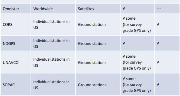
23 DGPS SOURCES 23

24 VRS NOW H-STAR Accuracy (Repeatable) < 4 (10 cm) Initialization < 1 min» Instant access to real time kinematic (RTK) corrections» Accuracy without the cost and maintenance of owning/operating base stations» Built in redundancy to ensure connectivity, consistency, and quality 24

25 RANGEPOINT RTX Accuracy (Repeatable) < 20 (50 cm) Initialization 1-5 min» Accuracy is a significant improvement over regional differential systems such as WAAS, EGNOS or SBAS» Use when the highest accuracy is not required» Satellite coverage as pictured, mobile data available worldwide 25
26 DATA PREPRATION: METHODOLOGY High Resolution Satellite Imagery Ground Control Points Identification High Resolution Satellite Imagery Object based Image Classification [Forest and Water Body Digitization ] GCP Points GPS Survey Georeferencing [Coordinate & Projection System] Topology Validation Topology Error Correction Land Parcel Identification & Validation Final Cadastral Map 26
27 LAND PARCEL TO GIS READY CADASTRAL MAP 27
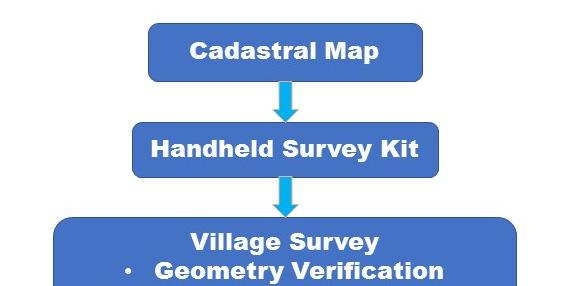
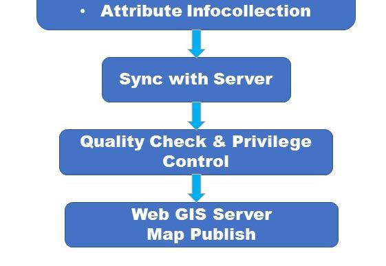
28 SURVEY: METHODOLOGY 28
29 KORBA: SURVEY MANAGEMENT 29
30 GIS READY DIGITIZATION 30
31 GIS READY MAP 31

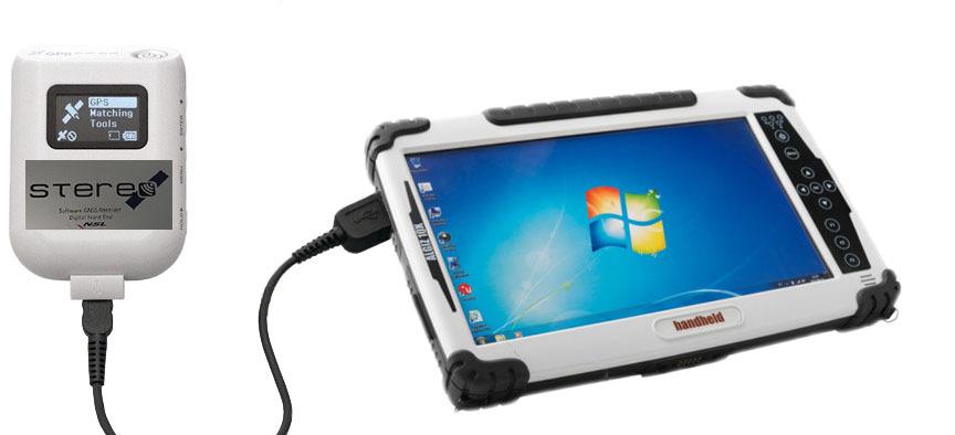
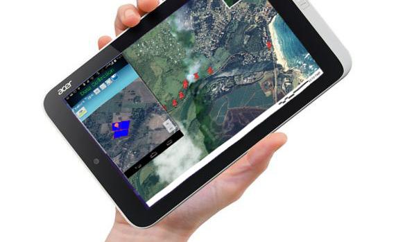
32 HANDHELD SURVEYING KIT 32

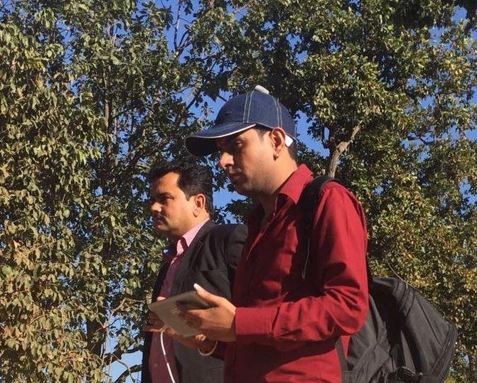
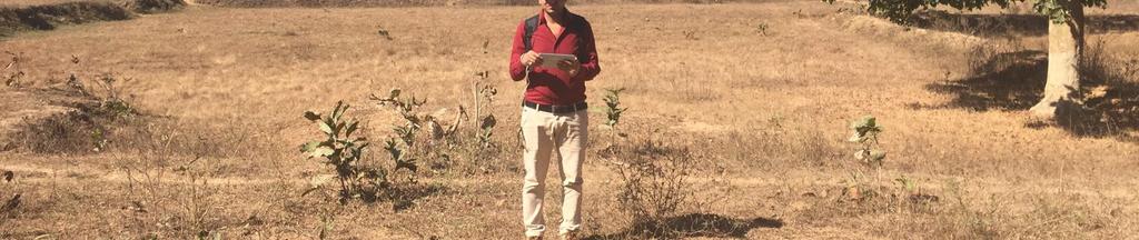
33 KORBA ON SITE SURVEY 33
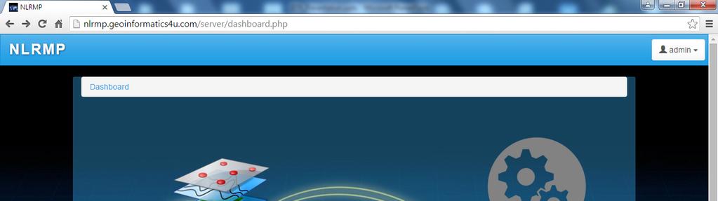

34 PROJECT MANAGEMENT PORTAL 34
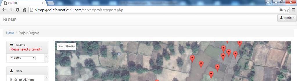
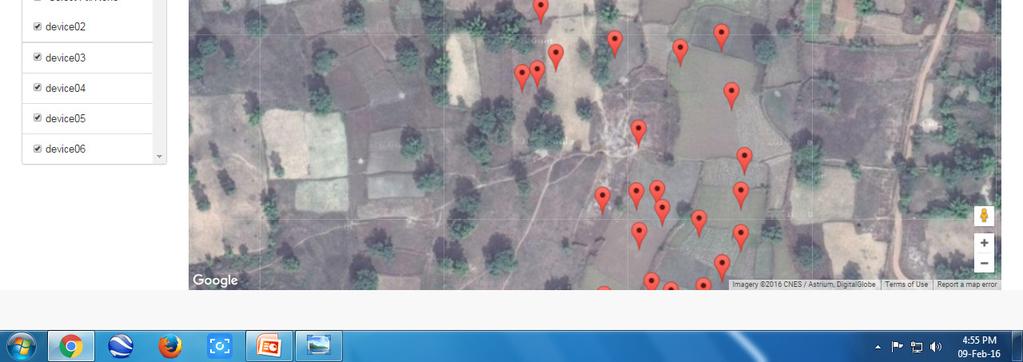
35 PROJECT MANAGEMENT PORTAL 35


36 PROJECT MANAGEMENT PORTAL: Attribute Information 36
37 RESULTS: GIS READY MAP PUBLISH Figure. Map with unique ownership records Figure. Map with unique Khasra numbers 37
38 RESULTS: ASSOCIATED ATTRIBUTE 38


39 RESULTS: GIS READY MAP SERVER 39
40 Thanks 40
A Geocoded Cadastral Fabric as a Precondition for a Sustainable Land Management System
 A Geocoded Fabric as a Precondition for a Sustainable Land Management System Gottfried KONECNY, Germany; J.P. LAUZON, Canada; Abdul Salam MOHAMMED, India Key words: SDI,, Parcel Boundaries, GPS-GNSS, Land
(Website: Ministry of Rural Development Government of India
 Department of Land Resources (Website: www.dolr.nic.in) Ministry of Rural Development Government of India 1 Computerization of Land Records Three Centrally Sponsored Schemes (CSS) : Strengthening of Revenue
Field surveying inspection using tablets
 Field surveying inspection using tablets Rami Farraj, Ahmad Sghyyer Survey of Israel, Lincoln 1, Tel-Aviv, Israel rami@mapi.gov.il ahmad@mapi.gov.il Key words: Field Surveying, Cadastre, Mapping Procedures
Alternatives for Economic Boundary Determination in the Establishment of a Cadastral System. Paper to the FIG Working Week 2012 Rome, May 9, 2012
 Alternatives for Economic Boundary Determination in the Establishment of a Cadastral System Paper to the FIG Working Week 2012 Rome, May 9, 2012 by Gottfried Konecny Emeritus Professor Leibniz University
FIG-WB Forum on Land Administration and reform in Sub-Sahara Africa
 FIG-WB Forum on Land Administration and reform in Sub-Sahara Africa Chris Mnyanga Ministry of Lands UNITED REPUBLIC OF TANZANIA] FIG WORKING WEEK, Abuja, NIGERIA 2013-6-10 MAY 2013 Country at Glance UNITED
A Method For Building Legal Digital Cadastre Without Using Cadastral Measurements Field Book Data Is It Accurate Enough?
 A Method For Building Legal Digital Cadastre Without Using Cadastral Measurements Field Book Data Is It Jad JARROUSH, Dmitri BRICKMAN, Israel Key words: Digital Cadastre, Least Squares Cadastral Computations,
Development of Mobile Cadastral Surveying System for Korean Cadastral Resurvey Project
 Development of Mobile Cadastral Surveying System for Korean Cadastral Resurvey Project Joon-Sik, KIM, Sang-Gu, KANG, Yun-Soo, CHOI, Republic of Korea Key words: Mobile Cadastral Surveying System, RTK-GPS,
Land Tenure and Geospatial Data and Technology
 Land Tenure and Geospatial Data and Technology Ioana Bouvier E3/Land and Urban, USAID Senior Geospatial Analyst January 23, 2018 January 23, 2018 1 OUTLINE 1. Overview of geospatial data and technology
Land Administration and Spatial Enablement Victoria s Experience. Chris McRae, Executive Director Land Victoria
 Land Administration and Spatial Enablement Victoria s Experience Chris McRae, Executive Director Land Victoria 4 th UN Land Administration Forum, October 2011 Outline About Land Victoria Land Victoria
MASS REGISTRATION OF LAND PARCELS USING FIT-FOR-PURPOSE LAND ADMINISTRATION: PROCEDURES AND METHODS
 MASS REGISTRATION OF LAND PARCELS USING FIT-FOR-PURPOSE LAND ADMINISTRATION: PROCEDURES AND METHODS TAREK ZEIN Hansa Luftbild AG, Germany zein@hansaluftbild.de Paper prepared for presentation at the 2017
Problems and Solution Proposals in Integration of Cadastral Data into Geographical Information System (GIS) in Turkey
 in Turkey") Problems and Solution Proposals in Integration of Cadastral Data into Geographical Information System (GIS) in Turkey Gülgün OZKAN, S. Savas DURDURAN, Ali ERDI and Bilal GIRGIN, Turkey Key words: Cadastre,
Problems and Solution Proposals in Integration of Cadastral Data into Geographical Information System (GIS) in Turkey Gülgün OZKAN, S. Savas DURDURAN, Ali ERDI and Bilal GIRGIN, Turkey Key words: Cadastre,
BULGARIAN CADASTRE A GUARANTEE FOR THE OWNERSHIP RIGHTS IN IMMOVABLE PROPERTIES
 4 TH INTERNATIONAL CONFERENCE RECENT PROBLEMS IN GEODESY AND RELATED FIELDS WITH INTERNATIONAL IMPORTANCE February 28 - March 2, 2007, Inter Expo Centre, Sofia, Bulgaria BULGARIAN CADASTRE A GUARANTEE
Reporting Thailand Cadastral System in Cadastre 2014 Trends BY VUTTINAN UTESNAN. Rajamangala University of Technology Krungthep
 Reporting Thailand Cadastral System in Cadastre 2014 Trends BY VUTTINAN UTESNAN Rajamangala University of Technology Krungthep Faculty of Engineering, Bangkok, THAILAND Topics INTRODUCTION THAILAND CADASTRAL
Reliability of the Italian cadastral system data quality and improvement prospects
 Reliability of the Italian cadastral system data quality and improvement prospects Eng. Franco MAGGIO (Central Director for Cadastral, Cartographic and Land Registration Services) Eng. Arturo ANGELINI
Land Consolidation in Sweden and Land
 From chaos to order... Land Consolidation in Sweden and Land Reform in Romaniasimilarities and discrepancies a comparison Mats Backman June 16 th 2008 Personal presentation Land Consolidation work in Sweden
Innovations in Education at Faculty ITC and within Land Administration Programme
 Innovations in Education at Faculty ITC and within Land Administration Programme Prof. Jaap Zevenbergen, Vice-Dean Education at Faculty ITC, Prof. Land Administration dr. Dimo Todorovski, Course Coordinator
Quality Improvement to Cadastral Information in Sweden
 Gunnar BLIXT, Sweden Key words: digital cadastre, quality, cadastral index map, real property register. SUMMARY Lantmäteriet is a governmental agency which gives support for creating an efficient and sustainable
A Radical Solution for the Cadastre Problem in Egypt Using Integrated GPS-GIS System
 A Radical Solution for the Cadastre Problem in Egypt Using Integrated GPS-GIS System Dr. Ehab NABIL NASSIF, Egypt Key words: ABSTRACT During the period 1897-1907 the cadastral surveying of Egypt was established.
LADM-based Crowdsourced 3D Cadastral Surveying Potential and Perspectives
 National Technical University Of Athens School of Rural and Surveying Engineering LADM-based Crowdsourced 3D Cadastral Surveying Potential and Perspectives Maria Gkeli, Surveying Engineer, PhD student
Cadastral Information System of Sofia
 Alexander LAZAROV and Hristo DECHEV, Bulgaria Key words: ABSTRACT A new Cadastre and Property Register Act (CPRA) was passed in April 2000, setting up rules for the maintenance of these two registers.
New Developments in the Hellenic Cadastre
 New Developments in the Hellenic Cadastre Prof. M. Kavouras Vice-president Ktimatologio S.A. (Hellenic Cadastre) The Hellenic Cadastre Background The Hellenic National Cadastre Organizational and institutional
The Integration of CORS Networks and the Cadastre and its Application in NSW, Australia
 The Integration of CORS Networks and the Cadastre and its Application in NSW, Australia Jai REDDY, Australia Key words: digital cadastre, CORS, GNSS, cadastral system SUMMARY In many countries, CORS networks
PROJECT INFORMATION DOCUMENT (PID) CONCEPT STAGE Report No.: AB3229 Project Name. Land Registry and Cadastre Modernization Project Region
 CONCEPT STAGE Report No.: AB3229 Project Name. Land Registry and Cadastre Modernization Project Region") PROJECT INFORMATION DOCUMENT (PID) CONCEPT STAGE Report No.: AB3229 Project Name Land Registry and Cadastre Modernization Project Region EUROPE AND CENTRAL ASIA Sector Central government administration
PROJECT INFORMATION DOCUMENT (PID) CONCEPT STAGE Report No.: AB3229 Project Name Land Registry and Cadastre Modernization Project Region EUROPE AND CENTRAL ASIA Sector Central government administration
Key Registers in Finland and some views of Cadastre 2035
 Presented at the FIG Working Week 2016, May 2-6, 2016 in Christchurch, New Zealand Key Registers in Finland and some views of Cadastre 2035 FIG Working Week, Christchurch New Zealand May, the 3rd, 2016
Functional system for cadastral plans
 , Republic of Macedonia Key words: Cadastre, Digital plans, Data, System SUMMARY The analysis shows that the real estate market in Republic of Macedonia grows daily. With the expansion of this market increases
Introduction to Land Tenure Administration
 Introduction to Land Tenure Administration Karol Boudreaux Land Tenure & Resource Rights Practice Lead, The Cloudburst Group January 22, 2018 January 22, 2018 1 WHAT WE LL COVER Background and Definitions
Establishing a Land policy reform and GPS Technology implementation in Burkina Faso
 Annual World Bank Conference on Land and Poverty 2013 Establishing a Land policy reform and GPS Technology implementation in Burkina Faso Presentation made by Moha EL-AYACHI, IAV Hassan 2, Morocco Paper
THE APPLICATION OF GIS AND LIS Solutions and Experiences in East Africa. Lenny Kivuti
 Using GIS and LIS for Planning Sustainable Development Bepic Group CHOGM, Malta 2005 THE APPLICATION OF GIS AND LIS Solutions and Experiences in East Africa Lenny Kivuti 21 November, 2005 Presented by
GAUSSCAD A WEBGIS APPLICATION FOR COLLECTING CADASTRAL DATA
 M.M. Moise GaussCAD a WebGIS Application for Collecting Cadastral Data GAUSSCAD A WEBGIS APPLICATION FOR COLLECTING CADASTRAL DATA Mihai-Mircea MOISE, S.C. GAUSS S.R.L., mihai.moise@gauss.ro Abstract:
SCOPE OF PRESENTATION
 INTERNATIONAL SYMPOSIUM AND EXHIBITION ON GEOINFORMATION Global Trends: Geoinformation For The New Economy Studies Toward the Development of Implementation Plan Of Coordinated Cadastral System for Peninsular
Land Information System as new instrument for Land Administration: Case Examples. Mike Cheremshynskyi Consultant, Land Administration Expert
 Land Information System as new instrument for Land Administration: Case Examples Mike Cheremshynskyi Consultant, Land Administration Expert Background Growth of population and fast urbanization in many
Government of India Ministry of Rural Development Department of Land Resources *******
 Government of India Ministry of Rural Development Department of Land Resources Notice Inviting Expression of Interest (EoI) G Wing, NBO Building, Nirman Bhawan, New Delhi ******* The Department of Land
By: Barney I. S. Laseko Programme Coordinator Prime Minister s Office TANZANIA
 2014 CONFERENCE ON LAND POLICY IN AFRICA 11 14 NOVEMBER, 2014 Focussed Discussion VIII Converting from Manual Land Registration to GIS Enabled Land Information System Case of Sub Saharan Africa Tanzania
Development of the New Cadastral Survey System in Tanzania
 Samwel S. KATAMBI, Tanzania Keywords: Cadastral Survey System, Cadastre, Land Administration, NSDI. SUMMARY In recent years the demand for cadastral survey informations in Tanzania has been increasing
The programme is implemented
 Surveying Property valuation and spatial data tools to assist in land restitution by Jaco de Kock, GISCOE Land and tenure reform in the South African government context are beyond talk and have received
Ⅱ-2. The Resurvey Project
 Presenter : JANG, Bong-Bae MLTM Ministry of land,transport and Maritime Affairs KIM, Soon-Tae KCSC Korea Cadastral Survey Corp., JANG, Bong-Bae Ⅰ. INTRODUCTION The Korean modern cadastral system was established
TSO1C: Land Reforms. Commission 7
 TSO1C: Land Reforms. Commission 7 Development of & Implementation LIS. Building an effective Partnership to Reform Uganda s Land Administration (7320) Gasant Jacobs, Head: Business Development. Tax & Accounting
The Development Strategy for Cadastre and Land Register in Finland
 1 2 The Development Strategy for and Land in Finland Arvo Kokkonen Ministry of Agriculture and Forestry Facts and figures of Finland - land area 304 530 km² - water area 33 615 km² - total area 338 195
FIG Congress 2010 Facing the Challenges Building the Capacity Sydney, Australia, April
 Setting up the infrastructure for improving the development of Cadastre in Greece Dr. Dimitris ROKOS, Dr. Konstantinos KYRIAZIS and Dr. Panos LOLONIS KTIMATOLOGIO S.A. (Hellenic Cadastre) Source: wikipedia
Universal Geo-database Connector Interface Component (UG-CIC) For Virtual Web-base GIS Server Essential For Real Estate Industry Uses
 For Virtual Web-base GIS Server Essential For Real Estate Industry Uses") Universal Geo-database Connector Interface Component (UG-CIC) For Virtual Web-base GIS Server Essential For Real Estate Industry Uses Jad Jarroush & Dr. Kobi Zaid Zaid Orniv Group L.T.D Israel kobi_z@zaidorniv.co.il
Universal Geo-database Connector Interface Component (UG-CIC) For Virtual Web-base GIS Server Essential For Real Estate Industry Uses Jad Jarroush & Dr. Kobi Zaid Zaid Orniv Group L.T.D Israel kobi_z@zaidorniv.co.il
Land Administration India Overview. March 17
 Land Administration India Overview March 17 1 Administration Criminal Administration law and order, policing, investigation, prosecution, jails... Revenue (Land) Administration land tenures, revenue, reforms,
Cadastre: definitions
 Introduction New vision towards a multipurpose cadastral system to support land management in Morocco Moha EL-AYACHI, El Hassane SEMLALI, Mohamed ETTARID, Driss TAHIRI, Institut Agronomique et Vétérinaire
Systematic Land Information Management (SLIM)
") Systematic Land Information Management (SLIM) By Mr. Jukka Nieminen Jaakko Pöyry Infra Soil and Water Ltd. Expert Group Meeting on Secure Land Tenure: New Legal Frameworks and Tools Nairobi 12 November
Systematic Land Information Management (SLIM) By Mr. Jukka Nieminen Jaakko Pöyry Infra Soil and Water Ltd. Expert Group Meeting on Secure Land Tenure: New Legal Frameworks and Tools Nairobi 12 November
Dimension Cadastre Stepping Beyond Limits
 Swiss Federal Directorate for Cadastral Surveying Dimension Cadastre Stepping Beyond Limits Dr. Daniel Steudler Background Think Tank active since 2012; aim is to identify the current trends in the geoinformation
Cadastral Framework Standards
 Cadastral Framework Standards The goal of the Data Standards and Recommendations Committee is to provide recommendations and guidelines to Indiana GIS user communities to facilitate the collection, maintenance
From 2D representation of the buildings into cadastral maps towards 3D GIS applications and BIM a case study for Prishtina
 From 2D representation of the buildings into cadastral maps towards 3D GIS applications and BIM a case study for Prishtina This is a Peer Reviewed Paper Fisnik LOSHI, Kosovo Keywords: 3D cadastre, property
Technology-driven solutions for the innovation of land administration and management
 Technology-driven solutions for the innovation of land administration and management Technology and economic growth - Studies*find link between technology innovation and national economic prosperity especially,
Project Management Forum. Eilat 2009
 Project Management Forum Eilat 2009 May 2009 FIG Working Week 1 Purpose To build on the sessions in Hong Kong and Stockholm To review the elements of PM To review examples of the stages of development
How a Cadaster Might Look Like in Finland in the Year 2035?
 How a Cadaster Might Look Like in Finland in the Year 2035? Mr. MARKKU Eino Olavi MARKKULA, Finland Key words; Cadastre, Coordinates, Digitised Process, Key Registers, Land Register Summary The Finnish
Developing Infrastructure Framework To Facilitate The Malaysia Multipurpose 3D Cadastre
 Developing Infrastructure Framework To Facilitate The Malaysia Multipurpose 3D Cadastre Sr Dr. Tan Liat Choon Sr Looi Kam Seng University of Technology Malaysia Department of Survey and mapping Malaysia
NEW DEVELOPMENTS IN THE REAL PROPERTY REGISTER AND CADASTRE IN LITHUANIA
 NEW DEVELOPMENTS IN THE REAL PROPERTY REGISTER AND CADASTRE IN LITHUANIA Jaunius Grigas E-mail: jaunius.grigas@registrucentras.lt Verona, 2008 FUNCTIONS OF STATE ENTERPRISE CENTRE OF REGISTERS Registration
Integration of Landregistry and Cadastre in the Netherlands. Presentation by Wim Louwman Chief registrar
 Integration of Landregistry and Cadastre in the Netherlands Presentation by Wim Louwman Chief registrar Programme Legal system in the Netherlands. History: - 1832: seperated public registers (Landregistry)
CADASTRE 2014: New Challenges and Direction
 CADASTRE 2014: New Challenges and Direction Anna KRELLE and Abbas RAJABIFARD, Australia Key words: Cadastre, Cadastre 2014, Land Administration SUMMARY Land and land related activities form part of the
CLICK HERE TO KNOW MORE
 CLICK HERE TO KNOW MORE LANDS AND SURVEYS DEPARTMENT SABAH, MALAYSIA GEO-CADASTRE IN LAND ADMINISTRATION: SABAH S EXPERIENCE Sr Hj SAFAR B UNTONG, FISM, MRICS Director, Lands & Surveys Department Sabah,
Reforming the Land Sector in Jamaica
 Silburn CLARKE and Llewelyn ALLEN, Jamaica Key words: tenure, cadastre, land reform, adjudication, public awareness, land titling, GPS, parcel mapping, traversing, land legislation, tenure regularisation,
COUNTRY REPORT ON CADASTRE AND LAND REGISTRAION IN IRAN. By: Hamid Berenjkar, IRAN
 COUNTRY REPORT ON CADASTRE AND LAND REGISTRAION IN IRAN By: Hamid Berenjkar, IRAN Key words: Comprehensive Cadastre, Cadastre System, Cadastral Survey, Land Book, Iran ABSTRACT Land registration and cadastral
Responsible and Innovative Land Administration
 Responsible and Innovative Land Administration An Example from Ethiopia 3 RD DECEMBER 2018 Outline A few words about NIRAS Fit-for-purpose: A low-tech disruptive approach? The REILA Project in Ethiopia
Cadastral Template 2003
 PCGIAP-Working Group 3 "Cadastre" FIG-Commission 7 "Cadastre and Land Management" Cadastral Template 2003 The establishment of a cadastral template is one of the objectives of Working Group 3 "Cadastre"
A Complete, Free Solution for Cadastral Map Management
 A Complete, Free Solution for Cadastral Map Management Gyula IVÁN Institute of Geodesy, Cartography & Remote Sensing (FÖMI) HUNGARY FIG Commission 7, Annual Meeting 11-15 September 2008., Verona, ITALY
Establishing Efficient Cadastral Surveying Plan in Accordance with Introducing World Geodetic Reference System in Korea
 Modern Environmental Science and Engineering (ISSN 2333-2581) December 2015, Volume 1, No. 6, pp. 299-303 Doi: 10.15341/mese(2333-2581)/06.01.2015/003 Academic Star Publishing Company, 2015 www.academicstar.us
From Parcel to Global Cadastre: Challenges and Issues of the Post-Reform Quebec Cadastre. Elisabetta Genovese, Francis Roy
 From Parcel to Global Cadastre: Challenges and Issues of the Post-Reform Quebec Cadastre Elisabetta Genovese, Francis Roy Department of Geomatic Sciences, Laval University, Québec, Canada elisabetta.genovese@scg.ulaval.ca
Egyptian Nationwide Title Cadastre System
 Kholoud SAAD, Egypt Key words: Cadastre, Registration, Urban, Rural, National Cadastre, Automation, reengineering. SUMMARY With growing need for integrated information, Enterprise Solutions has become
The creation of a Survey Accurate Cadastral Map for surveyed areas in Trinidad & Tobago
 The creation of a Survey Accurate Cadastral Map for surveyed areas in Trinidad & Tobago Anesh Gopee, Keith Miller and Charisse Griffith Charles University of the West Indies Trinidad aneshtt@yahoo.com
OVERVIEW AND PROGRESS DEPARTMENT OF LANDS, THAILAND
 OVERVIEW AND PROGRESS OF DEPARTMENT OF LANDS, THAILAND presented by PEERA YOMWAN Division of Mapping Technology, DOL The Asean Federation of Land Surveying and Geomatics (AFLAG) : April 11, 2017 @ BKK
LRIMS Cadastre Module
 LRIMS Cadastre Module User Requirements and Functionality (Seychelles Case Study) John Latham, NRL Renato Cumani, NRL Luigi Simeone, NRL Summary Background User Requirements Business Model Application
SECTOR PUBLIC CADASTRES AND REGISTERS MARKET PARTICIPANTS
 E-SERVICES TO CITIZENS, GOVERNMENT AND BUSINESSES. LITHUANIA EXPERIENCE Arvydas Bagdonavičius State Enterprise Centre of Registers Arvydas.Bagdonavicius@registrucentras.lt REGISTERS AND IS MANAGED BY THE
Progress Report on Green Paper. Dr. Paddy Prendergast. on behalf of the. IIS Commission on Land Registration
 Progress Report on Green Paper By Dr. Paddy Prendergast on behalf of the IIS Commission on Land Registration Paddy Prendergast - Chair Brendan Sweeny - Hempenstall Surveys Paul Corrigan - P Corrigan Associates
Hi-tech Survey Operation using Modern Technologies: Concept & Process Flow
 Hi-tech Survey Operation using Modern Technologies: Concept & Process Flow Presented by Sri Biswaranjan Rath Asst. Director,CLR Board of Revenue, Odisha Limitations of present system of surveying Survey
Revenue. Major part of ULB's revenue comes by means of:
 Revenue Major part of ULB's revenue comes by means of: Collecting property tax Issuing trade licenses Alloting its land and buildings to carry out business Collecting usage charges and service fees for
Hybrid Cadastre Pilot Project Guidelines for Public Land Disposition Surveys Operations Division
 Hybrid Cadastre Pilot Project Guidelines Operations Division January 12, 2015 Version Update Version No. Date Summary of Changes 2.0 January 12, Table of Contents 2015 Table of Contents added to Guidelines.
The computerised land reallotment process in Turkey and the Netherlands in multi-purpose land consolidation projects
 The computerised land reallotment process in Turkey and the Netherlands in multi-purpose land consolidation projects FIG Conference, 15 April 2010, Sydney Louisa J. M. Jansen (Netherlands), Mustafa Karatas,
The Contribution of Forest Owners Associations for the Forest Cadastre Implementation. João Gaspar Ana Navarro Ferreira PORTUGAL
 The Contribution of Forest Owners Associations for the Forest Cadastre Implementation João Gaspar Ana Navarro Ferreira PORTUGAL Motivation Lack of forestry cadastre; Unify all FOAs databases with common
Aspect of preliminary activities in the function of supporting NSDI
 Sonja DIMOVA, Republic of Macedonia Key words: e-governance, geospatial data, NSDI, INSPIRE, metadata SUMMARY The successful establishment of the NSDI in the true sense of the word cannot be performed
A CADASTRAL GEODATA BASE FOR LAND ADMINISTRATION USING ARCGIS CADASTRAL FABRIC MODEL A CASE STUDY OF UWANI ENUGU, ENUGU STATE, NIGERIA
 A CADASTRAL GEODATA BASE FOR LAND ADMINISTRATION USING ARCGIS CADASTRAL FABRIC MODEL A CASE STUDY OF UWANI ENUGU, ENUGU STATE, NIGERIA BY Ndukwu, Raphael. Ike Department of Geoinformatics & Surveying University
Jack McKenna, Director of Business Development, Africa and the Caribbean
 Presented at the FIG Working Week 2016, May 2-6, 2016 in Christchurch, New Zealand Jack McKenna, Director of Business Development, Africa and the Caribbean FIG WORKING WEEK 2016 Fit for Purpose Parcel
International funding projects in Republic Geodetic Authority
 International funding projects in Republic Geodetic Authority Serbia: Republic Geodetic Authority Workshop Exploring Funding Instruments for NMCA 7-8 November 2012 Republic Geodetic Authority Republic
LIS a motivation for SDI initiative
 Eric Mwaikambo Ardhi University Dar es Salaam Tanzania Overview Status of LIS in Tanzania Relationship between SDI and LIS Spatial Standards LIS a motivation for SDI initiative Conclusion & Recommendations
Generic land administration business. FAO Workshop Rome, November 18-19,
 Generic land administration business FAO Workshop Rome, ovember 18-19, 2010 18.11.2010 1 Objectives Agree about what is the core land administration business common to all countries Derive the corresponding
Cadastral Information System for M.I. Wushishi Housing Estate.
 Cadastral Information System for M.I. Wushishi Housing Estate. Kemiki O. A 1 * Odumosu J.O 2 Ayoola A.B 1 Popoola N.I 1 1, Department of Estate Management and Valuation, Federal University of Technology,
Directorate of Survey and Mapping NAMIBIA. Cadastral Information System. Vehupisa Kasuko Tjatindi Surveyor Directorate of Survey and Mapping NAMIBIA
 Vehupisa Kasuko Tjatindi Directorate of Survey and Mapping NAMIBIA Tel: +64 61 965000 Directorate of Survey and Mapping NAMIBIA Cadastral Information System Introduction Over the past few decades cadastral
Trimble Land Solutions -Transforming the way land
 Sanjeev Trehan Regional Manager - SAARC MARCH 2016 Trimble Land Solutions -Transforming the way land tenure is secured and land assets are managed. Government Opportunity Challenge Implementation of secure
Topographic Signs Important Context of 3D Cadastre
 STATE GEODETIC ADMINISTRATION Gruška 20,10 000 Zagreb, Croatia Delft University of Technology Faculty of Architecture and the Built Environment Department OTB GIS Technology Section Topographic Signs Important
Meeting the Changing National Geospatial Information Needs. Palitha Udayakantha Surveyor General - Sri Lanka
 Meeting the Changing National Geospatial Information Needs Palitha Udayakantha Surveyor General - Sri Lanka Sri Lanka Location Latitude 5 55 10-9 50 6 North Longitude 79 31 19-81 52 36 East Area 65610
ABSTRACT Land Administration System in Lithuania
 ABSTRACT Land Administration System in Lithuania 1. General introduction to the Lithuanian Land Administration System and State Enterprise Centre of Registers ( shortly SECR) Lithuania has established
Land Administration And Spatial Data Infrastructures
 Land Administration And Spatial Data Infrastructures Ian WILLIAMSON, Donald GRANT and Abbas RAJABIFARD Centre for SDIs and Land Administration Department of Geomatics University of Melbourne, Australia
XXV FIG CONGRESS KUALA LUMPUR, MALAYSIA, JUNE 2014.
 XXV FIG CONGRESS KUALA LUMPUR, MALAYSIA, 16-21 JUNE. THEME: ENGAGING THE CHALLENGES, ENHANCING THE RELEVANCE THE DILEMMA Malaysia, 16 21 OF June RESTRUCTURING THE LAND GOVERNANCE SYSTEM IN NIGERIA BY UKAEJIOFO,
TOWARDS E-LAND ADMINISTRATION - ELECTRONIC PLANS OF SUBDIVISIONS IN VICTORIA
 TOWARDS E-LAND ADMINISTRATION - ELECTRONIC PLANS OF SUBDIVISIONS IN VICTORIA Mohsen Kalantari 1, Chris Lester 2, David R Boyle 3, Neil Coupar 4 1 eplan Coordinator 2 SPEAR Manager 3 Deputy Surveyor General
CADASTRAL WORKS in TURKEY AND GDLRC (TKGM)
") CADASTRAL WORKS in TURKEY AND GDLRC (TKGM) NOVEMBER 2011 SOME NUMBERS ABOUT TURKEY Area :783.600 Km 2 Population : 747 millions (2008) Number of land parcels : 555 millions Villages and quarters : 52.437
CADASTRAL WORKS in TURKEY AND GDLRC (TKGM) NOVEMBER 2011 SOME NUMBERS ABOUT TURKEY Area :783.600 Km 2 Population : 747 millions (2008) Number of land parcels : 555 millions Villages and quarters : 52.437
Analytical Cadastre in Israel: Restoring Land Boundaries Based on Photogrammetric Tools
 Analytical Cadastre in Israel: Restoring Land Boundaries Based on Photogrammetric Tools Yohanan GAVISH and Prof. Yerach DOYTSHER, Israel Key words: analytical cadastre; photogrammetry; restoring land boundaries;
Land Information Management in Southern Africa Focus on technology management training in Surveying and Mapping in Namibia
 Land Information Management in Southern Africa Focus on technology management training in Surveying and Mapping in Namibia Chris Paresi, Urban and Regional Planning and Geo-Information Management Department,
IMPLEMENTATION OF LEGAL DIGITAL CADASTRE IN ISRAEL
 IMPLEMENTATION OF LEGAL DIGITAL CADASTRE IN ISRAEL Dr. Gershon STEINBERG, Israel INTRODUCTION The Survey of Israel (SOI), Israel s national surveying and mapping agency, plans to implement full legal digital
University of Nairobi LAND INFORMATION SYSTEM FOR LAND MANAGEMENT IN KENYA. CASE STUDY: NAIROBI COUNTY, BURUBURU PHASE I ESTATE
 University of Nairobi LAND INFORMATION SYSTEM FOR LAND MANAGEMENT IN KENYA. CASE STUDY: NAIROBI COUNTY, BURUBURU PHASE I ESTATE BY Justus Amdavi F56/69371/2013 Supervisor: Mr Jasper Mwenda CONTENTS Introduction
D DAVID PUBLISHING. Mass Valuation and the Implementation Necessity of GIS (Geographic Information System) in Albania
 in Albania") Journal of Civil Engineering and Architecture 9 (2015) 1506-1512 doi: 10.17265/1934-7359/2015.12.012 D DAVID PUBLISHING Mass Valuation and the Implementation Necessity of GIS (Geographic Elfrida Shehu
Journal of Civil Engineering and Architecture 9 (2015) 1506-1512 doi: 10.17265/1934-7359/2015.12.012 D DAVID PUBLISHING Mass Valuation and the Implementation Necessity of GIS (Geographic Elfrida Shehu
Low Cost Cadastral Data Aquisition?
 Low Cost Cadastral Data Aquisition? Jacobus Meijer and Christiaan Lemmen (Netherlands): 21 May 2011 Abstract Spatial Cadastral Data (Mapping) Participatory Development Some low cost approaches in cadastral
UNIVERSITY OF NAIROBI
 UNIVERSITY OF NAIROBI GENERATION OF SURVEY PLAN FROM DEMARCATION PLAN: CASE STUDY OF MUKA MUKUU SETTLEMENT FARMS. By OGUTU KANGA STELLAMARIS F19/2553/2008 Supervisor: Mr. B.M Okumu A project report submitted
Cadastral and Right of Way Data Sharing
 Cadastral and Right of Way Data Sharing May 2010 TRS 1006 This Transportation Research Synthesis (TRS) provides summaries of recent research and implementation efforts on a topic of current interest. Online
Modernizing Land Administration Systems
 Presented at the FIG Congress 2018, May 6-11, 2018 in Istanbul, Turkey Modernizing Land Administration Systems B r e n t J o n e s P E, PLS E s r i Land Administration Systems GIS is the Technology Platform
Interoperability in surveying
 Interoperability in surveying Ron Bloksma Kadaster Dutch Land Registry Thread in my career Law Organisation Processes Information Legal interoperability Organisational interoperability Semantic interoperability
The Fit- for-purpose Concept
 The Fit- for-purpose Concept Building Spatial Frameworks for Sustainable Land Governance in Sub-Sahara Africa Prof. Stig Enemark Honorary President Aalborg University, Denmark LAND POLICIES AND LAND GOVERNANCE,
CADASTRE SURVEY PRACTICE (SGHU 4323)
") CADASTRE SURVEY PRACTICE (SGHU 4323) WEEK 11-eCADASTRE SR DR. TAN LIAT CHOON 07-5530844 016-4975551 1 OUTLINE Coordinated Cadastral System National Digital Cadastral Database Multipurpose Cadastre 3D Cadastre
CADASTRE SURVEY PRACTICE (SGHU 4323) WEEK 11-eCADASTRE SR DR. TAN LIAT CHOON 07-5530844 016-4975551 1 OUTLINE Coordinated Cadastral System National Digital Cadastral Database Multipurpose Cadastre 3D Cadastre