Arch-Laclede s Landing Station
|
|
|
- Joanna Evans
- 5 years ago
- Views:
Transcription


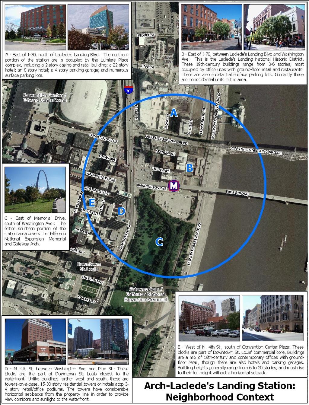
1 Arch-Laclede s Landing Station This station profile describes existing conditions around the Arch-Laclede s Landing MetroLink Station. This is one of a set of profiles for each of the MetroLink System s 37 light rail stations. These profiles present demographic and employment data from within a half-mile of the station, and describe the land uses and building types within a quarter-mile of the station. They also identify Metro-owned parcels that may offer opportunity to encourage new development around the station; other vacant and underutilized sites that may offer opportunity for infill development; and the physical, policy, and zoning barriers to TOD that currently exist. These profiles serve as a basis for conversation and planning with the community, elected officials, developers, financial institutions, and other stakeholders. The Arch-Laclede s Landing Station directly serves two of the region s most recognized landmarks, the Gateway Arch/Jefferson National Expansion Memorial, and the Laclede s Landing Historic District. The entire southern portion of the station area is occupied by the Arch Grounds. North of Washington Avenue lies the historic Eads Bridge and Laclede s Landing, a national Historic District containing several blocks of three- to six-story, 19 th century warehouse and commercial buildings that have been converted for modern office use. Most of these buildings contain groundfloor retail space, largely tenanted by restaurants, bars, and other entertainment uses; currently, there are no residential units on the Landing. North of the Landing sits Lumiere Place, a large-scale development containing a twostory casino and retail building; a 22-story hotel; an eight-story hotel; a four-story parking garage; and numerous surface parking lots. The western portion of the station area includes a small part of the Downtown commercial core, mostly developed with a mix of modern and 19 th century mid-rise and high-rise office buildings. The quarter-mile station area covers 129 lots on 20 blocks, with a total assessed value of $135,941,230. Regional Accessibility by Transit The MetroBus System does not directly serve the Landing Station, but MetroLink offers direct connections and timely travel to a wide range of housing opportunities, shopping, jobs, and other high-demand destinations: MetroLink (RED LINE) o Scott Air Force Base (40 minutes) o Lambert International Airport (40 minutes Table 1: Average MetroLink Boardings Estimates* Total Monthly Average Daily Boardings Boardings Weekday Weekend METROLINK STATION AVERAGE 36,500 1, MISSOURI STATION AVERAGE 42,000 1, ARCH-LACLEDE'S LANDING METROLINK STATION 34,900 1,050 1,370 *M etro Fiscal Year July June MetroLink (RED AND BLUE LINE) o Downtown St. Louis (3 minutes) o Central West End (25 minutes) As can be seen in Table 1 below, although average boardings at Arch-Laclede s Landing are slightly lower than average for stations in Missouri and system-wide, it is only about 4% less than the system-wide monthly and daily averages.
2 Demographics, Housing, and Employment Most of the land around the Downtown Station is occupied by large civic uses and office towers, but there are approximately 1,300 people living within a half-mile of the station. As shown in Table 2 below, the residential population appears to consist mostly of working-age professionals, with 47% of the population between the ages of 35 and 64. Half of residents possess high school diplomas, and a third of residents have a college or graduate degree. Nearly three-quarters of the households make less than $50,000 per year, and a third of individual residents live below the Federal poverty line. Table 2: Demographics Population Population Income Acres Age Persons in poverty 32.0% Population 1, % Density (persons/acre) % Household income % $0-9, % Sex % $10,000-14, % Male 57.2% % $15,000-24, % Female 42.8% $25,000-49, % Source: American Community Survey, US Census Bureau *Education statistics apply to persons age 25 or older. Education* $50,000-74, % No diploma 11.5% $75,000-99, % High school 55.2% $100, % College degree 11.7% Graduate degree 21.6% Household size % % 3 3.4% 4 4.4% % As shown in Table 3 below, the half-mile station area has an average residential density of 2.5 housing units per acre; this is to be expected for an area mostly developed with non-residential uses. Most (87%) of the housing stock was built between the 1940s and 1990s, with only 2.1% built since All of the occupied housing is rental units, and the vacancy rate is 30%. Forty-three percent of rental units are priced between $500 and $749 per month. In order to commute to work, 65% of residents use their own vehicle, 6.2% use transit, and 19% walk to work. 2
3 Table 3: Housing and Transportation Housing Housing Transportation Housing Units Owner-occupied housing values Vehicle Availability Total units 1,326 < $100,000 N/A Zero-vehicle households 32.4% Density (DUs/acre) 2.5 $100, ,999 N/A Owner-occupied N/A Occupied % $200, ,999 N/A Renter-occupied 32.4% Owner-occupied 0 0% $300, ,999 N/A Renter-occupied % $500,000+ N/A Workers* 633 Vacant % Rental prices Means of commute* Housing Age No cash rent % Drives alone (SOV) 65.2% Pre-1940s % $ % Carpool 0% 1940s-1990s 1, % $ % Transit 6.2% 2000s % $ % Motorcycle 0% Source: American Community Survey, US Census Bureau * Workers refers to persons age 16 or over who selfidentified as being employed. $ % Walk 18.8% $ % Other 0% $ % Work at Home 9.8% Table 4 provides data on employment within the station area. Within a half-mile of the Arch-Laclede s Landing MetroLink Station there are 1,897 firms and agencies employing over 25,000 people. The vast majority of these jobs fall into the professional, scientific, and technical services sectors. Other sectors providing a considerable number of jobs include accommodation and food services, and finance and insurance. Table 4: Employment, Half-Mile Radius NAICS Industry Firms Jobs NAICS Industry Firms Jobs 11 Agriculture, Forestry, Fishing & Professional, Scientific, Technical Hunting Services 1,142 10, Mining, Quarrying, and Oil & Gas Management of Companies and Extraction Enterprises Administrative & Support, Waste 22 Utilities Management & Remediation Services 23 Construction Educational Services Manufacturing Health Care & Social Assistance Wholesale Trade Arts, Entertainment, and Recreation Retail Trade Accommodation and Food Services 78 5, Transportation & Warehousing Other Services Information Public Administration Finance & Insurance 80 3, Unclassified Real Estate, and Rental & Leasing Total: 1,897 25,041 Source: ReferenceUSA as accessed via the St. Louis City Library Database 3

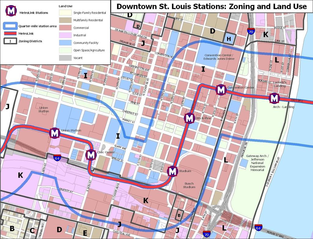
4 Neighborhood Context: Summary The Arch-Laclede s Landing Station directly serves two of the region s most recognized landmarks, the Gateway Arch/ Jefferson National Expansion Memorial, and the Laclede s Landing Historic District. The entire area south of Washington Avenue is occupied by the Arch Grounds and a two-story parking garage. North of Washington Avenue lies the Laclede s Landing National Historic District, which contains several blocks of three- to six-story, 19 th century warehouse and commercial buildings that have been converted for modern office use. Most of these buildings contain ground-floor retail space, largely tenanted by restaurants, bars, and other entertainment uses; currently, there are no residential units on the Landing. The northern portion of the station area holds the Lumiere Place large-scale development, including a two-story casino and retail building; a 22-story hotel; an eight-story hotel; a four-story parking garage; and numerous surface parking lots. The western portion of the station area includes a small part of the Downtown commercial core, mostly developed with a mix of modern and 19 th century, six- to 20-story office buildings. Fourth Street also includes two 30-story residential towers and a 15-story hotel tower, each with considerable horizontal setbacks and set atop a two- or three-story retail base. The map on this page illustrates the general station location and quarter-mile station area. The map on the following page provides a more detailed description of existing land uses and prevailing development patterns within that quarter-mile area. 4
5 5
6 6
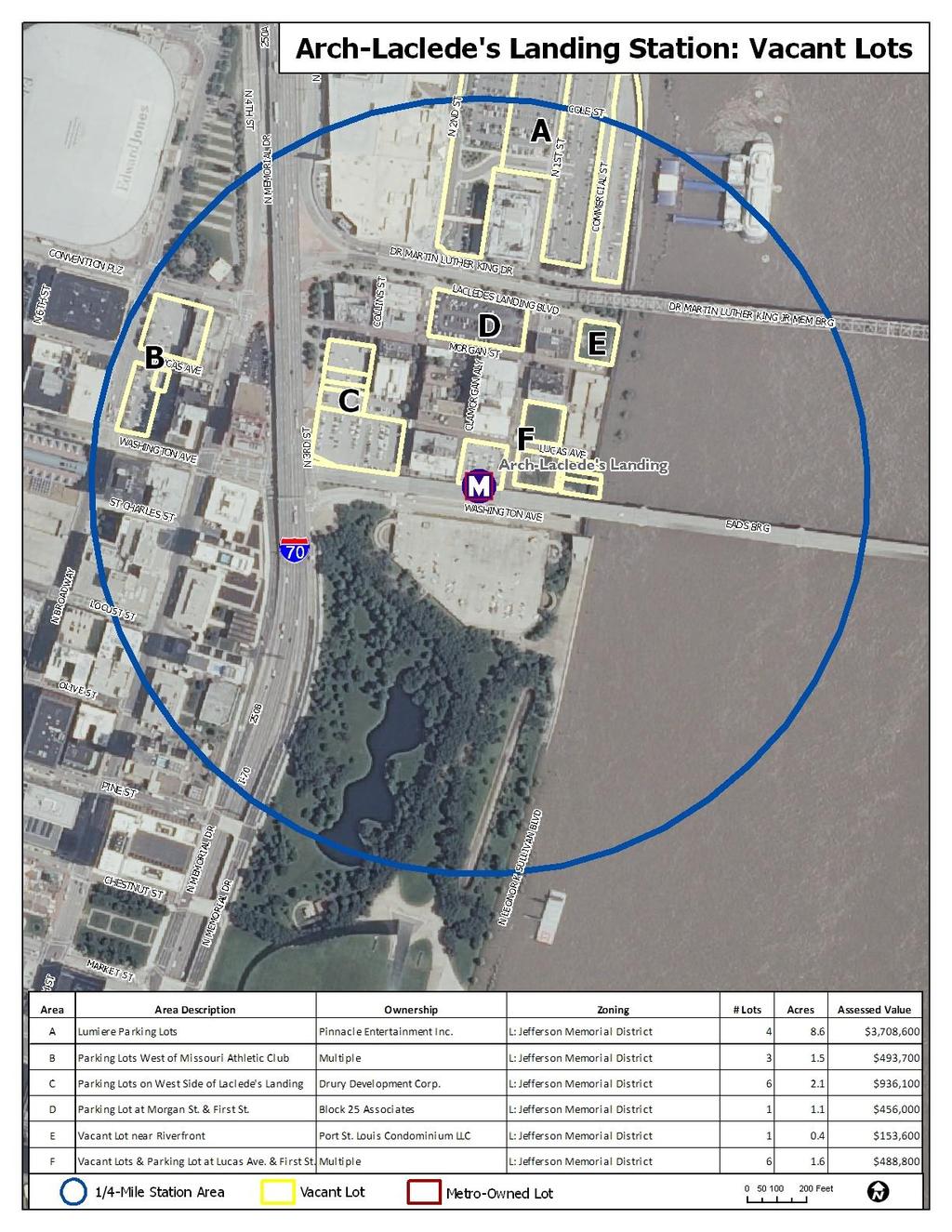
7 Zoning, Land Use Policies, and Community Plans The map and table on the following pages illustrate and explain current zoning regulations within a quarter-mile of both the Arch-Laclede s Landing Station. The combined station area is entirely within the City of St. Louis, and all lots are covered by the L: Jefferson Memorial District. Potential Development Opportunities and Issues Availability of land: There are two fairly large vacant lots within the quarter-mile station area, both within the Laclede s Landing Historic District. These two vacant lots offer a total of two acres. There are also four distinct concentrations of surface parking lots, totaling approximately 13 acres, that may offer some opportunity for new development. TOD within the Arch-Landing Station area will depend largely on the redevelopment of surface parking lots or selective infill on two vacant lots. Zoning: Existing zoning regulations within the combined station area do not appear to pose any significant barriers to new or infill TOD. The entire station area is within the L: Jefferson Memorial District, which allows all uses except a set list of heavy manufacturing and industry. The L District also establishes a very liberal building envelope, determined by a flexible prism that starts with a base height of 200 that can be increased through the provision of building setbacks; however, the L District does set an absolute maximum height of 751 above mean sea level. The L District requires a minimum lot size of sq. ft. per dwelling unit, and sets no minimum parking requirement. 7
8 8
9 Table 5: Arch-Landing Station: Existing Zoning Regulations L District Type Jefferson Memorial District Uses Permitted All uses allowed, except for a defined set of heavy manufacturing, industrial, and noxious uses By Special Permit Outdoor pay telephones Minimum Lot Area Maximum Building Height Residential/mixed use, up to 8 stories / 100' = 250 sq.ft. per DU. Residential/mixed use over 8 stories = 100 sq.ft. per DU Flexible, based on 200' "reference prism" and setbacks; maximum height 751' above sea level Minimum Front Yard None required Minimum Side Yard None required Minimum Rear Yard None required Parking Miscellaneous *DU = dwelling unit Residential = 1 per DU; retail = 1 per 700 sq.ft. over 3,000 sq.ft.; restaurants = 1 per 200 sq.ft. over 1,000 sq.ft.; hotels = 1 per 4 sleeping rooms; industrial and wholesale =1 per 10 employees There are three zoning overlay districts meant to provide greater flexibility and good planning for new developments. A Community Unit Plan (CUP) District allows a large-scale planned development for an area of at least 15 acres. Planned Unit Development (PUD) Districts are similar to CUPs, but at a smaller scale. Special Use Districts (SUDs) can be used to encourage particular development outcomes in specific areas, by allowing either more or less flexibility in permitted uses. All of these overlay districts require formal review and approval of the rezoning and a detailed site plan. 9
Downtown Stations: 8 th & Pine and Convention Center
 Downtown Stations: 8 th & Pine and Convention Center This station profile describes existing conditions around two MetroLink Stations in Downtown St. Louis, the 8 th & Pine and Convention Center Stations.
North Hanley Station. o Flower Valley Shopping Center o Cross Keys Shopping Cente #49 North Lindbergh MetroBus
 North Hanley Station This station profile describes existing conditions around the North Hanley MetroLink Station. This is one of a set of profiles for each of the MetroLink System s 37 light rail stations.
Forest Park DeBaliviere Station
 Forest Park DeBaliviere Station This station profile describes existing conditions around the Forest Park-DeBaliviere MetroLink Station. This is one of a set of profiles for each of the MetroLink System
NOVEMBER 2016 AARP IN ST. LOUIS & CITIZENS FOR MODERN TRANSIT PLACEMAKING STRATEGIES FOR ST. LOUIS TRANSIT DRAFT
 NOVEMBER 2016 AARP IN ST. LOUIS & CITIZENS FOR MODERN TRANSIT PLACEMAKING STRATEGIES FOR ST. LOUIS TRANSIT DRAFT APPENDIX AARP IN ST. LOUIS + CMT + ARCTURIS + THE INNIS GROUP 51 APPENDIX APPENDIX A - RIDERSHIP
Attachment 3. Guelph s Housing Statistical Profile
 Attachment 3 Guelph s Housing Statistical Profile Table of Contents 1. Population...1 1.1 Current Population (26)...1 1.2 Comparative Growth, Guelph and Ontario (21-26)...1 1.3 Total Household Growth (21
The Southgate Economic Development Department provides economic development services for the Township of Southgate.
 4. Industrial Development 4.1 Industrial Development Assistance The Southgate Economic Development Department provides economic development services for the. The Economic Development Department: Provides
Existing Land Use. Typical densities for single-family detached residential development in Cumberland County: 1
 Existing Land Use A description of existing land use in Cumberland County is fundamental to understanding the character of the County and its development related issues. Economic factors, development trends,
5,787 SF Bank-Owned Property
 FOR SALE 5,787 SF Bank-Owned Property Total SF 5,787 Acreage 0.40 Parcel ID 0820D022 Zoning C-3. General Commercial District List Price $64,000.00 5,787± sf office (based on courthouse records) 0.4± acres
AUBURN BANKSTOWN BLACKTOWN HOLROYD PARRAMATTA THE HILLS. West Central District Demographic & Economic Characteristics
 AUBURN BANKSTOWN BLACKTOWN HOLROYD PARRAMATTA THE HILLS West Central District Demographic & Economic Characteristics Contents The West Central District 3 People 4 Population 4 Age Profile 6 Households
APPENDIX C CHARACTERISTICS OF THE ENERGIZE PHOENIX CORRIDOR
 APPENDIX C CHARACTERISTICS OF THE ENERGIZE PHOENIX CORRIDOR BACKGROUND ON RESIDENTIAL AND COMMERCIAL BUILDINGS IN THE EP CORRIDOR The 10-mile EP corridor (Figure G1) is a highly diverse, mixed-use L-shaped
MONTGOMERY COUNTY RENTAL HOUSING STUDY. NEIGHBORHOOD ASSESSMENT June 2016
 MONTGOMERY COUNTY RENTAL HOUSING STUDY NEIGHBORHOOD ASSESSMENT June 2016 AGENDA Model Neighborhood Presentation Neighborhood Discussion Timeline Discussion Next Steps 2 WORK COMPLETED Socioeconomic Analysis
THIS IS AN EXAMPLE REPORT
 Ann Arbor Retail Space 2,000-4,000 SF, High Traffic Prepared on THIS IS AN EXAMPLE REPORT John, It was good speaking with you today. I've identified several spaces that appear to meet your needs. Look
WAREHOUSE FOR LEASE with Refrigeration / Freezers
 Dunlap Works 8205 Dunlap Street Houston, Texas 77074 WAREHOUSE FOR LEASE with Refrigeration / Freezers NEWLY REMODELED BEFORE Property Features: Newly remodeled Convenient location in Southwest Houston
Demographics Review Multi-family Housing Data & Characteristics. Triplexes, quadplexes, and apartments. Development Potential Future Considerations
 Horizon Discussion: Arlington 2012 Multi-Family Housing Profile City Council Meeting September 17, 2013 6 Overview Demographics Review Multi-family Housing Data & Characteristics Triplexes, quadplexes,
Appendix A: Guide to Zoning Categories Prince George's County, Maryland
 Appendix A: Guide to Zoning Categories Prince George's County, Maryland RESIDENTIAL ZONES 1 Updated November 2010 R-O-S: Reserved Open Space - Provides for permanent maintenance of certain areas of land
US Worker Cooperatives: A State of the Sector
 US Worker Cooperatives: A State of the Sector Worker cooperatives have increasingly drawn attention from the media, policy makers and academics in recent years. Individual cooperatives across the country
I-45 and Parker Road 6500 North Freeway - Houston, Texas 77056
 Large Pylon Sign Excellent Exposure to I-45 Freeway 6,554 SQ FT. SPACE AVAILABLE I-45 and Parker Road 6500 North Freeway - Houston, Texas 77056 NOW Lx 6,554 SQ FT and 1,000 SQ FT LEASE SPACE BPI Realty
OFFICE / WAREHOUSE FOR LEASE in Northwest Houston
 West 34th Street Complex 2217-2221 West 34th Street Houston, Texas 77018 OFFICE / WAREHOUSE FOR LEASE in Northwest Houston Property Features: Frontage on West 34th Street in Garden Oaks 20 ceiling height
Beltway 8 & Hwy 90. SEC Beltway 8 and Hwy 90 (Crosby Freeway) Houston, Texas 77049
 Houston, Texas 77049") Beltway 8 & Hwy 90 SEC Beltway 8 and Hwy 90 (Crosby Freeway) Houston, Texas 77049 BPI Realty Services Inc 3800 SW Freeway Suite 304 Houston, TX 77027 Phone: (281) 530-0900 Fax: (281) 530-0690 Beltway 8
Beltway 8 & Hwy 90 SEC Beltway 8 and Hwy 90 (Crosby Freeway) Houston, Texas 77049 BPI Realty Services Inc 3800 SW Freeway Suite 304 Houston, TX 77027 Phone: (281) 530-0900 Fax: (281) 530-0690 Beltway 8
housing plan May 18, 2009
 housing plan May 18, 2009 Cherry Hill Township and Planning Board reserve the right to make further changes to this Housing Element & Fair Share Plan. The need or desirability of a change may arise from
III. Housing Profile and Analysis
 III. Housing Profile and Analysis 3-1 III. Housing Profile and Analysis A. Housing Types Information on the type of housing available is important to have a clear picture of what Lacey has in its housing
TOD and Equity. TOD Working Group. James Carras Carras Community Investment, Inc. August 7, 2015
 TOD and Equity TOD Working Group James Carras Carras Community Investment, Inc. August 7, 2015 What is Equitable TOD? Equity is fair and just inclusion. Equitable TOD is the precept that investments in
For Sale. 2,880+/- sf bldg on 3.64+/- acres. Formerly operated as Alternative Automotive. Frontage and signage on Memorial Hwy. Ample parking.
 For Sale 17530 State Route 536 Mount Vernon, WA 2,880+/- sf bldg on 3.64+/- acres Formerly operated as Alternative Automotive. Frontage and signage on Memorial Hwy. Ample parking. Furniture, Fixtures and
Employment Projections to 2022
 Employment Projections to 2022 Agriculture, Forestry and Fishing Inner MetropolitanMelbourne Mining-10 Manufacturing Electricity, Gas, Water and Waste Services Construction Wholesale Trade Retail Trade
Mesa Tidwell Shopping Center Mesa Road at Tidwell Road Houston, Texas 77028
 Mesa Tidwell Shopping Center 9413-9419 Mesa Road at Tidwell Road Houston, Texas 77028 Property Features: 3,000 SF Available Only grocery anchored center in the area Pad site available Adjacent to area
FOR LEASE IN MEDFORD, OREGON CARDINAL AVE. Cardinal Ave & Crater Lake Hwy, Medford, Oregon
 CRATER LAKE HWY FORMER RETAIL PADS FOR LEASE IN MEDFORD, OREGON ANCHORS OPENING SUMMER 2018! CARDINAL AVE available 10,000 SF available 10,000 SF available 8,490 SF LEAR WAY available 7,000 SF Location
Beechnut Village Shopping Center
 Beechnut Village Shopping Center 8145 South Highway 6 at Beechnut Street Houston, Texas 77083 availabilities: 2,400 sq. ft. space available 2017 Demographics 1-mile 3-miles 5-miles Est. Population 19,662
CRANBERRY TOWNSHIP PROFILE:
 CRANBERRY TOWNSHIP PROFILE: 2015 Market Analysis Update MARKET ANALYSIS UPDATE 2015 Prepared by Delta Development Group, Inc. 2525 Rochester Road Ste 400 Cranberry Township PA 16066 For more information,
Woodbridge Shopping Center Highway 6 & Voss Road
 Woodbridge Shopping Center Highway 6 & Voss Road Highlights - Shadow Space to Kroger Store - Located at the Hard Corner of a Lighted Intersection on Hwy 6 - Pads Ideal for Fast Food, Bank, or Restaurant
POPULATION FORECASTS
 POPULATION FORECASTS Between 2015 and 2045, the total population is projected to increase by 373,125 residents to reach 2.2 million. Some areas will see major increases, while other areas will see very
San Francisco HOUSING INVENTORY
 2008 San Francisco HOUSING INVENTORY San Francisco Planning Department April 2009 1 2 3 4 1 888 Seventh Street - 227 units including 170 off-site inclusionary affordable housing units; new construction
Bellaire Gessner Shopping Center 8880 Bellaire Boulevard Houston, Texas 77036
 Bellaire Gessner Shopping Center 8880 Bellaire Boulevard Houston, Texas 77036 Property Features: Located next to Fiesta Mart Surrounded by a diverse dense Residential community Adjacent to Strake Jesuit
Future Land Use Categories & Nodes December 23, Future Land Use Categories
 Future Land Use Categories & Nodes December 23, 2015 A note regarding nodes: Descriptions for nodes are located in the general recommendations handout. Node locations are set in part by the Auburn Interactive
Mohave County General Plan
 63 64 65 66 67 68 69 70 71 The Land Use Diagram is not the County's zoning map. 13 It is a guide to future land use patterns. Zoning and area plan designations may be more restrictive than the land use
Minneapolis Trends. Permitted residential conversions, remodels and additions. Permitted non-residential conversions, remodels and additions
 Minneapolis Trends A Quarterly Overview of Socioeconomic & Housing Trends in Minneapolis Highlights for the fourth quarter of 21 fourth quarter 21 change from 4Q-1 3Q-1 4Q-9 Labor force 217,947 residents
REQUEST STAFF RECOMMENDATION. On April 26, 2012, Signature Books Inc., represented by Dave Richards, submitted petitions for the following amendments:
 PLANNING COMMISSION STAFF REPORT Signature Books Zoning Map Amendment and an Amendment to the North Temple Area Plan Petitions PLNPCM2012-00254 PLNPCM2012-00255 July 11, 2012 Planning Division Department
PART 3 RESIDENTIAL ZONING DISTRICTS. Designation of Residential Zoning Districts and Purpose Statements.
 PART 3 S Section 301. Designation of and Purpose Statements. See Table 3-1 herein this Section for the designations and purpose statements of the respective Residential Zoning Districts which are shown
FOR SALE CORAL GABLES DEVELOPMENT SITE ALHAMBRA CIRCLE CORAL GABLES, FL 33134
 for for a FOR SALE CORAL GABLES DEVELOPMENT SITE 367-371 ALHAMBRA CIRCLE CORAL GABLES, FL 33134 THE OFFERING Foundry Commercial is pleased to exclusively offer for sale a portfolio of two properties located
Kinzie Industrial Corridor
 Mayor Emanuel s Industrial Corridor Modernization Kinzie Industrial Corridor Fulton Market Innovation District Plan Implementation September 19, 2017 Rahm Emanuel, Mayor David Reifman, Commissioner Dept.
NEW AND REVISED. Organization, format and editing. Numbering, page layout, tables, charts, illustrations General editing and plain English voice
 NEW AND REVISED Organization, format and editing Numbering, page layout, tables, charts, illustrations General editing and plain English voice ORGANIZATION AND FORMAT Chapter 1 Introductory Provisions
Salem HNA and EOA Advisory Committee Meeting #6
 Salem HNA and EOA Advisory Committee Meeting #6 Residential Land Policies Employment Land Policies Policy Discussions with the Committee Outcome of today s meeting Direction from this Committee on proposed
Minneapolis Trends. Permitted residential conversions, remodels and additions. Permitted non-residential conversions, remodels and additions
 Minneapolis Trends A Quarterly Overview of Socioeconomic & Housing Trends in Minneapolis Highlights for the fourth quarter of 214 fourth quarter 214 Labor force 219,419 residents change from 4Q-14 3Q-14
Addressing the Impact of Housing for Virginia s Economy
 Addressing the Impact of Housing for Virginia s Economy A REPORT FOR VIRGINIA S HOUSING POLICY ADVISORY COUNCIL NOVEMBER 2017 Appendix Report 2: Housing the Commonwealth's Future Workforce 2014-2024 Jeannette
KARMAR REALT Y GROUP, INC. C O M M E R C I A L & I N V E S T M E N T R E A L E S T A T E S E R V I C E S S A L E
 KARMAR REALT Y GROUP, INC. C O M M E R C I A L & I N V E S T M E N T R E A L E S T A T E S E R V I C E S S A L E 99 ALDAN AVENUE, CONCORDVILLE, PA 19331 DESCRIPTION: 30,000 +/- SQ. FT. OF BUILDING FULLY
The Planning and Zoning Commission also recommended a building height of 58 with these added mitigating measures.
 April 27, 2018 Town Council Matt Pielsticker, AICP Planning Director Town of Avon 1 Lake Street Avon, CO 81620 Re: PUD 17001 - Village at Avon Planning Area F Amendment Dear Avon Town Council: This letter
Generic Environmental Impact Statement. Build-Out Analysis. City of Buffalo, New York. Prepared by:
 Generic Environmental Impact Statement Build-Out Analysis City of Buffalo, New York 2015 Prepared by: TABLE OF CONTENTS 1.0 INTRODUCTION 1 2.0 METHODOLOGY 2 3.0 EXISTING LAND USE 3 4.0 EXISTING ZONING
RESIDENTIAL DEMAND ANALYSIS
 RESIDENTIAL DEMAND ANALYSIS ST. JOSEPH DOWNTOWN MARKET AREA CITY OF ST. JOSEPH, MISSOURI BUCHANAN COUNTY October 2007 ACKNOWLEDGMENTS DOWNTOWN REVITALIZATION AND ECONOMIC ASSISTANCE FOR PLANNING CONSULTANT
Minneapolis Trends. Permitted residential conversions, remodels and additions. Permitted non-residential conversions, remodels and additions
 Minneapolis Trends A Quarterly Overview of Socioeconomic & Housing Trends in Minneapolis Highlights for the third quarter of 213 third quarter 213 Labor force 219,777 residents change from 3Q-13 2Q-13
Metropolitan Planning Commission. DATE: April 5, 2016
 TO: FROM: Metropolitan Planning Commission MPC Staff DATE: April 5, 2016 SUBJECT: Petition of Nine Line Inc. Robert McCorkle, Agent PIN: 2-1034-01-002 380.5 Acres Aldermanic District: 5 (Shabazz) County
EAST-WEST CORRIDOR EXISTING CONDITIONS
 EAST-WEST CORRIDOR EXISTING CONDITIONS EXISTING CONDITIONS : PREVIOUS PLANS & STUDIES 7 recent planning efforts areas of overlap are of particular interest EXISTING CONDITIONS : LAND USE large concentration
Ch. 14 CAPITOL HILL. Historic Districts - Apartment and Multi-family Development
 Historic Districts - Apartment and Multi-family Development Ch. 14 CAPITOL HILL A HISTORY OF APARTMENT AND MULTI-FAMILY DEVELOPMENT The following background on the historical development of apartment and
ABILENE ZONING REGULATIONS TABLE OF CONTENTS
 ABILENE ZONING REGULATIONS TABLE OF CONTENTS ARTICLE SECTION TITLE PAGE 1 TITLE AND PURPOSE 1-1 Title. 1-1 1-2 Purpose and Intent.. 1-1 1-3 Consistency with Comprehensive Plan 1-2 1-4 Jurisdiction. 1-2
Route 6 Corridor Study Bristol Planning Commission Meeting #1. May 25, 2016 FITZGERALD & HALLIDAY, INC. Innovative Planning, Better Communities
 Route 6 Corridor Study Bristol Planning Commission Meeting #1 May 25, 2016 FITZGERALD & HALLIDAY, INC. Innovative Planning, Better Communities Today s Agenda 1. Introductions 2. Study overview Scope Schedule
Alamo Corners Shopping Center
 Alamo Corners Shopping Center 1449 West Duranta Street & US-83 Alamo, Texas 78516 Presented By: Bridge Realty Partners, Inc. 16910 Dallas Parkway, Suite 110 Dallas, Texas 75248 P 972.235.7888 F 972.235.3570
Market Trends Generated on 09/27/2018 Page 1 of Lorenzen Rd, Tracy, CA , San Joaquin County. Pricing Trends
 12 Lorenzen Rd, Tracy, CA 95304-8188, San Joaquin County Pricing Trends Median Sale Price to Current Value - Tax The percentage of properties that have increased or decreased in value based on the year
ORDINANCE NO. Adopted by the Sacramento City Council Date Adopted
 ORDINANCE NO. Adopted by the Sacramento City Council Date Adopted AN ORDINANCE DELETING VARIOUS CHAPTERS OF TITLE 17 OF THE SACRAMENTO CITY CODE AND ADDING CHAPTER 17.444 TO THE SACRAMENTO CITY CODE, RELATING
Rapid City Planning Commission Rezoning Project Report
 Rapid City Planning Commission Rezoning Project Report April 21, 2016 Item #9 Applicant Request(s) Case # 16RZ011; a request to rezone property from Central Business District to General Commercial District
1057 Canton RD Marietta, GA 30066
 1057 Canton RD Marietta, GA 30066 +/- 1.49 Acres Presently Zoned LI $350,000 With all utilities available. Very little lot prep necessary for most uses. Two Level steppes descending from the street level.
Housing. Approved and Adopted by City Council November 13, City Council Resolution City Council Resolution
 5 Housing Approved and Adopted by City Council November 13, 2018 Chapter 5 Housing 5.1 City Council Resolution 2018-096 5.2 Fontana General Plan CHAPTER 5 Housing This chapter of the General Plan Update
Planning Justification Report
 Planning Justification Report Kellogg s Lands City of London E&E McLaughlin Ltd. June 14, 2017 Zelinka Priamo Ltd. Page i TABLE OF CONTENTS Page No. 1.0 2.0 2.1 2.2 3.0 4.0 5.0 5.1 5.2 5.3 5.4 5.5 5.6
Offered for Sale. Bradfield Creek Townhomes. Presented By:
 Presented By: Multi-Family Investments Mishan Ice, Broker 10000 North Central Expressway, Suite 400 Dallas TX 75231 214-394-0818 mishan@prop-co.com Offered for Sale Bradfield Creek Townhomes 832 Courtenay
FOR SALE 140 N. BRENTWOOD CLAYTON, MO FOR SALE DOWNTOWN CLAYTON OPPORTUNITY LAND AVAILABLE FOR REDEVELOPMENT
 FOR SALE 140 N. BRENTWOOD CLAYTON, MO FOR SALE DOWNTOWN CLAYTON OPPORTUNITY LAND AVAILABLE FOR REDEVELOPMENT TABLE OF CONTENTS Section1 Section 2 Section 3 Section 4 Offering Summary Development Opportunity
From Policy to Reality
 From Policy to Reality Updated ^ Model Ordinances for Sustainable Development 2000 Environmental Quality Board 2008 Minnesota Pollution Control Agency Funded by a Minnesota Pollution Control Agency Sustainable
PLANNING AND IMPLEMENTING TOD: KEY FACTORS FOR SUCCESS. Sujata Srivastava Knowledge Corridor TOD Workshop June 5, 2013
 PLANNING AND IMPLEMENTING TOD: KEY FACTORS FOR SUCCESS Sujata Srivastava Knowledge Corridor TOD Workshop June 5, 2013 6-year old partnership dedicated to improving practice through technical assistance,
MPN. S broad street corner development site. 701 s broad street, philadelphia, pa 19147
 S broad street corner development site 701 s broad street, philadelphia, pa 19147 1601 Walnut St, Philadelphia, PA 19102 215.413.4900 www.mpnrealty.com corner development site FOR SALE 701 s broad street
$26.00/SF/YR, NNN. I-5 116,966 ADT (15) Barbur Blvd (Hwy 99W) 15,600 ADT (16) Capitol Hwy 18,173 ADT (15)
 Barbur Blvd (Hwy 99W) 15,600 ADT (16) Capitol Hwy 18,173 ADT (15)") FOR LEASE Capitol Corner PORTLAND, OREGON Location: Available Space: Rental Rate: Comments: Traffic CountS: At the corner of I-5 & SW Barbur Blvd intersecting at Capitol Hwy 1,300 SF (former Salon) 1,755
FOR LEASE Capitol Corner PORTLAND, OREGON Location: Available Space: Rental Rate: Comments: Traffic CountS: At the corner of I-5 & SW Barbur Blvd intersecting at Capitol Hwy 1,300 SF (former Salon) 1,755
8023 Alhambra AVE South gate, CA
 8023 Alhambra AVE South gate, CA O F F E R I N G M E M O R A N D U M 2MATTHEWS REAL ESTATE INVESTMENT SERVICES 2 APARTMENT NAME CONTENTS 04 PROPERTY OVERVIEW 06 AREA OVERVIEW 10 FINANCIAL OVERVIEW 12 RENT
Town of Frisco 2015 Land Use Profile
 Town of Frisco 2015 Land Use Profile I. Introduction The 2015 Land Use Profile correlates closely with several of the quality of life direction statements from the 2011 Frisco Community Plan. This study
Existing Conditions: Economic Market Assessment
 Existing Conditions: Economic Market Assessment Introduction The US 24/40 Corridor Study examined existing conditions as they related to economic and commercial market assessments, existing land use, and
BOARD OF TRADE BUILDING
 CRA FOR LEASE IN PORTLAND, OREGON BOARD OF TRADE BUILDING Location SW 4th Avenue and Oak Street, Portland, Oregon Available Spaces 1,806 SF (suite 105) space located at SW Oak St, just off 4 th Avenue
2018 Housing Plan Element and Fair Share Plan
 2018 Housing Plan Element and Fair Share Plan Township of Lebanon Hunterdon County, New Jersey Prepared by the Lebanon Township Planning Board in consultation with Michael P. Bolan, AICP/PP January 24,
Santa Rosalia Santa Rosalia Drive Los Angeles, CA PROPERTY HIGHLIGHTS
 Santa Rosalia 4525 Santa Rosalia Drive Los Angeles, CA PROPERTY HIGHLIGHTS Michael Salerno Executive Vice President (310) 202-9166 michaels@mdrealtycorp.com 3627 Motor Avenue Los Angeles, CA 90034 29 units
Tonawanda Brownfield Opportunity Area
 Tonawanda Brownfield Opportunity Area Pre-Nomination Study Agenda What is a Brownfield & the Brownfield Opportunity Area (BOA) Program Characteristics Demographic/Economic Land Characteristics Environmental
4 LAND USE 4.1 OBJECTIVES
 4 LAND USE The Land Use Element of the Specific Plan establishes objectives, policies, and standards for the distribution, location and extent of land uses to be permitted in the Central Larkspur Specific
Analysis of Commercial Buildings in the GeoDirectory Database Q Vacancy Rates
 GEOVIEW Quarterly Commercial Vacancy Rates Report Analysis of Commercial Buildings in the GeoDirectory Database Q4 2013 This is the first GeoView end of year analysis. It is based on the quarterly reports
Orange Avenue Corridor Study
 Focusing on Orange Avenue in Winter Park, this study identifies its composition, existing conditions, and examines highest and best use opportunities from a zoning and development perspective. Its aim
FOR SALE PORTLAND, ME BAYSIDE PROPERTIES. rare urban infill development opportunity. The Boulos Company
 PORTLAND, ME FOR SALE BAYSIDE PROPERTIES rare urban infill development opportunity The Boulos Company 1 Executive Summary 2 parcel Map 3 portland map 4 zoning map 5 zoning details 6 parcel details 7 traffic
Article 04 Single Family Residential Districts
 Article 04 Article 04 Section 04.01 Intent (a) R1A Residence District. The R1A Single Family Residential District is established to include areas of low density single-family residences and limited agricultural
8Land Use. The Land Use Plan consists of the following elements:
 8Land Use 1. Introduction The Land Use Plan consists of the following elements: 1. Introduction 2. Existing Conditions 3. Opportunities for Redevelopment 4. Land Use Projections 5. Future Land Use Policies
1636 NORTH VENTURA AVENUE
 1636 NORTH VENTURA AVENUE VENTURA, CA 93001 OFFERING MEMORANDUM N O N - E N D O R S E M E N T A N D D I S C L A I M E R N O T I C E Non-Endorsements Marcus & Millichap is not affiliated with, sponsored
FEASIBILITY REPORT. 1486, 1490 and 1494 Clementine. Prepared by: Lloyd Phillips & Associates Ltd. For: Ottawa Salus
 DRAFT FEASIBILITY REPORT 1486, 1490 and 1494 Clementine Prepared by: Lloyd Phillips & Associates Ltd. For: Ottawa Salus LPA File No. 1008 Lloyd Phillips & Associates June 9, 2010 Feasibility Report Page
Nine Story, LEED Certified Class A Office Building. One Summerlin Festival Plaza Drive, Las Vegas, Nevada 89135
 ine Story, LEED Certified Class A Office Building One Summerlin 1980 Festival Plaza Drive, Las Vegas, evada 89135 property highlights LEED Certified Silver, core and shell. Green building initiatives throughout,
4.11 POPULATION AND HOUSING
 4.11 POPULATION AND HOUSING INTRODUCTION This section of the Draft Environmental Report (Draft EIR; DEIR) describes the current population and demographic characteristics and housing and employment conditions
JUDSON AND STAHL PAD SITE
 JUDSON AND STAHL PAD SITE NWQ JUDSON & STAHL ROAD SAN ANTONIO, TX THOMAS TYNG 1604 ROLLING OAKS MALL PD C 44 7,1 T EC BJ SU 1604 Selma D MADISON HIGH SCHOOL 54 8,4 CP THE FORUM PD 1C,93 14 LIVE OAK CROSSING
Demographics 1 Mile 3 Mile 5 Mile
 Fiesta Anchored Center End Cap For Lease Location: 1175 Edgebrook, Houston, TX 77034 Nestled in the retail hub of Edgebrook and I-45 South. Grocery anchored Fiesta Center with end caps available. Additional
PROPERTY OFFERING. 99 Ross Rd, Preston CT 06365
 PROPERTY OFFERING 99 Ross Rd, Preston CT 06365 Welcome to the Town of Preston. Preston is a rural country town where farmhouses, ponds, brooks, open fields, and stonewalls dot the landscape. Located directly
Burlington Unincorporated Community Plan
 Burlington Unincorporated Community Plan June 30, 2010 Meeting Page 1 of 24 Table of Contents (Page numbers to be inserted) I. Background a. Location and Community Description b. Planning of Unincorporated
STATE OF AFFORDABLE HOUSING
 STATE OF AFFORDABLE HOUSING IN NORTH DAKOTA 2010 REPORT Sponsored by: EXECUTIVE SUMMARY North Dakota is showing positive growth in a variety of economic factors the lowest unemployment rate in the country,
FEC The purpose of the Flexible Use Employment Center classification is to provide for areas of employment uses situated on individual sites or in
 FEC The purpose of the Flexible Use Employment Center classification is to provide for areas of employment uses situated on individual sites or in campus-style parks. Primary uses in the FEC classification
2. Second dwellings and medical hardships per Article 10.
 Article 7: Zoning Districts and Zoning Map Section 135: NON-URBAN ZONING DISTRICT (NU) A. Purpose The intent of this district is to allow agricultural, recreational, wildlife, forestry, open space, farming
SAN IPSE CAPITAL OF SILICON VALLEY
 CITY OF SAN IPSE CAPITAL OF SILICON VALLEY TO: HONORABLE MAYOR AND CITY COUNCIL COUNCIL AGENDA: 12-13-16 ITEM: 4.4 Memorandum FROM: Toni J. Taber, CMC City Clerk SUBJECT: SEE BELOW DATE: December 1, 2016
Missing Middle Housing Types Showcasing examples in Springfield, Oregon
 Missing Middle Housing Types Showcasing examples in Springfield, Oregon MissingMiddleHousing.com is powered by Opticos Design Illustration 2015 Opticos Design, Inc. Missing Middle Housing Study Prepared
Summary Report on the Economic Impact of the State Center Project Baltimore, MD
 Summary Report on the Economic Impact of the State Center Project Baltimore, MD Prepared for: Maryland Department of Transportation Prepared by: BAE Urban Economics March 2011 Summary of Key Findings Phase
Economic Significance of the Property Industry to the. OTAGO Economy PREPARED FOR PROPERTY COUNCIL NEW ZEALAND BY URBAN ECONOMICS
 Economic Significance of the Property Industry to the OTAGO Economy PREPARED FOR PROPERTY COUNCIL NEW ZEALAND BY URBAN ECONOMICS 2016 ABOUT PROPERTY COUNCIL NEW ZEALAND Property Council New Zealand is
4. Parks and Recreation Fee Facility Needs and Cost Estimates Fee Calculation Nexus Findings 24
 TABLE OF CONTENTS CHAPTER PAGE 1. Introduction and Summary of Calculated Fees 1 1.1 Background and Study Objectives 1 1.2 Organization of the Report 2 1.3 Calculated Development Impact Fees 2 2. Fee Methodology
DIVISION 7. R-6 AND R-6A RESIDENTIAL ZONES* The purpose of the R-6 residential zone is:
 Date of Draft: March 6, 2015 DIVISION 7. R-6 AND R-6A RESIDENTIAL ZONES* Sec. 14-135. Purpose. The purpose of the R-6 residential zone is: (a) To set aside areas on the peninsula for housing characterized
RAE EXCLUSIVE RESIDENTIAL ZONE A residential district exclusively for low density single family housing and accessory uses.
 KNOX COUNTY ZONING ORDINANCE DISTRICT SUMMARY REQUIREMENTS 2/11/2009 RAE EXCLUSIVE RESIDENTIAL ZONE A residential district exclusively for low density single family housing and accessory uses. 10,000 sq.
UPDATE Board of Selectmen June 20, 2017
 MAPLE STREET I-1 AREA DRAFT ZONING BYLAW & DEVELOPMENT STANDARDS Town of Danvers, MA UPDATE Board of Selectmen June 20, 2017 The Danvers Team: Brovitz Community Planning & Design Dodson & Flinker Danvers
Housing Issues Report Shoreline Towers Inc. Proposal 2313 & 2323 Lake Shore Boulevard West. Prepared by PMG Planning Consultants November 18, 2014
 Housing Issues Report Shoreline Towers Inc. Proposal 2313 & 2323 Lake Shore Boulevard West Prepared by PMG Planning Consultants November 18, 2014 PMG Planning Consultants Toronto, Canada M6A 1Y7 Tel. (416)
Housing Study & Needs Assessment
 Housing Study & Needs Assessment Phase II Public Engagement Presentation #2 Winston-Salem, North Carolina January 25, 2018 MEETING OVERVIEW Welcome & Introductions Purpose & Goals Community Discussions