Mohave County General Plan
|
|
|
- Audra Lindsey
- 5 years ago
- Views:
Transcription

1 63
2 64
3 65
4 66
5 67
6 68
7 69
8 70
9 71
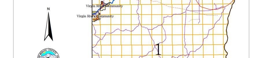
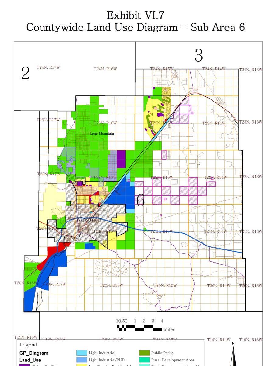
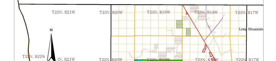
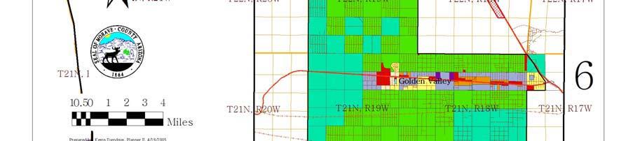
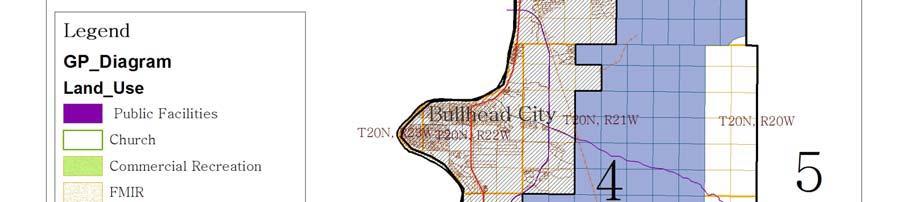
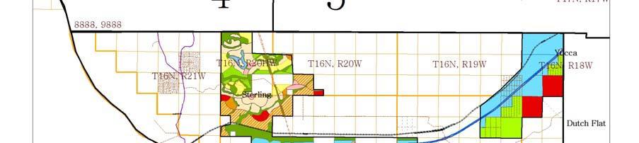
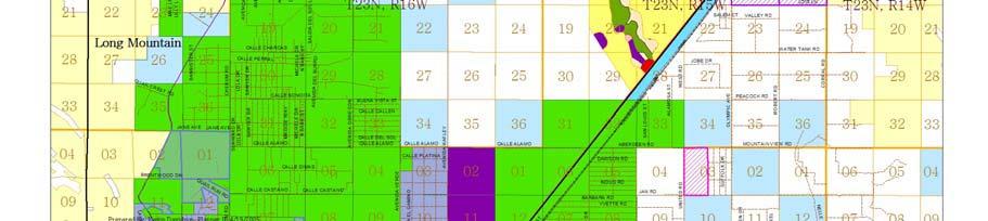
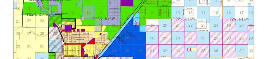
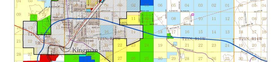
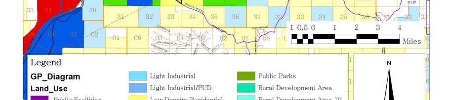
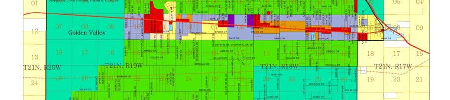
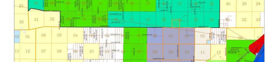
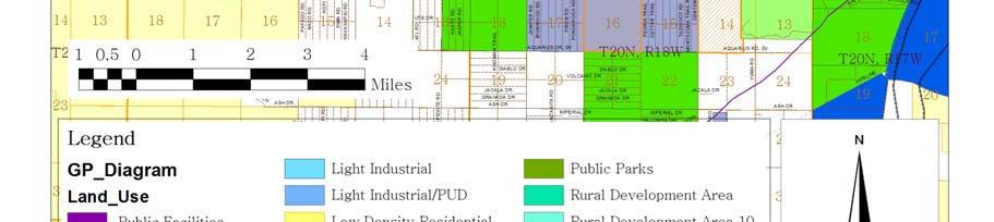
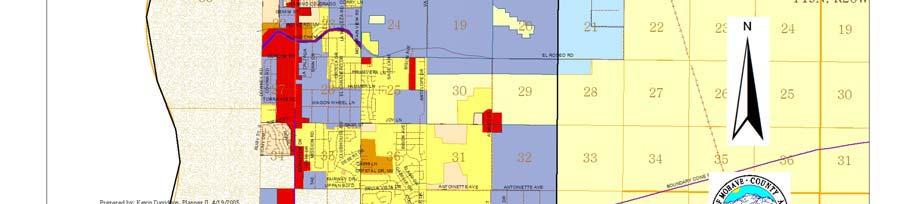
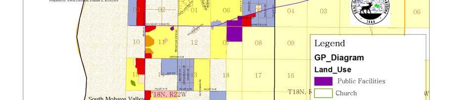
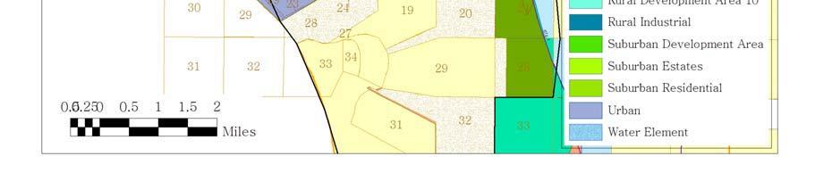
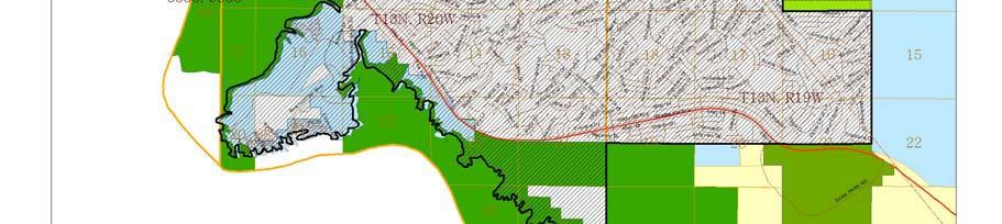
10 The Land Use Diagram is not the County's zoning map. 13 It is a guide to future land use patterns. Zoning and area plan designations may be more restrictive than the land use categories of the Land Use Diagram. Land Use Categories A consistent set of land use categories is used in all Land Use Diagrams to describe the type and intensity of use anticipated. Exhibit VI.13 shows the relationship between planning area types and land use categories. Exhibit VI.14 lists these categories and briefly summarizes their policy intent. Each category is described in more detail in the following section of this Element. In each case, the exhibit gives a name and abbreviation for the land use category. For residential uses, the exhibit shows the range of densities consistent with each category. Density is expressed as the number of Dwelling Units per Acre (DU/A). 14 For example, the category "Medium Density Residential" includes development at densities ranging from five to twelve dwelling units per acre. The method for calculating a development project's density is described in Exhibit VI.15. The goals and policies of the Land Use Element define this method and other factors to be considered in evaluating a project's consistency with the Land Use Diagram. In addition to the residential density range, Exhibit VI.14 also indicates the typical uses found in each land use category. This list is not comprehensive, and does not address the accessory uses that a zoning district might permit. It simply describes the primary uses typically found in this category, so residents and property owners can understand the County's general policy intent for a certain area. The Land Use Diagram uses sixteen categories to describe the future land uses in Mohave County. Land use categories are meant to be more general than zoning districts -- there may be several zoning districts that could be consistent with a particular land use category. In some cases, the land uses found in an Area Plan are also more specific than these land use categories. These categories, which are listed in Exhibit VI.13, are described in more detail below. Included in the following general descriptions of each category is a statement of whether land uses within the category are intended to be rural, suburban or urban in character. 13 Zoning is part of the property owner's "bundle of rights" and is based on an adopted ordinance which prescribes a set of discrete uses and activities while the land use diagram shows the idealized or highest and best use of the property based on contemporary planning theory and public input. 14 For planning purposes, these densities are expressed in terms of gross land area. -72-
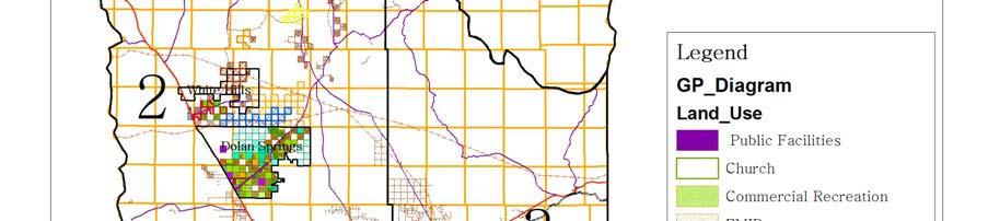
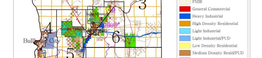
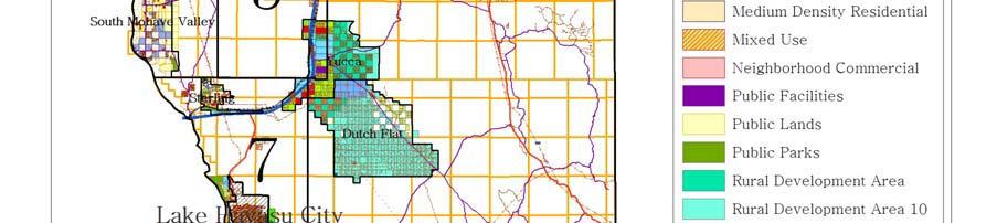
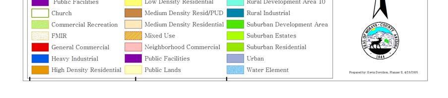
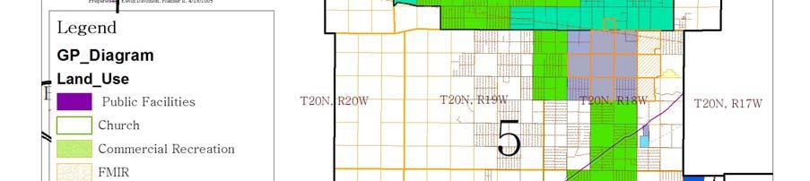
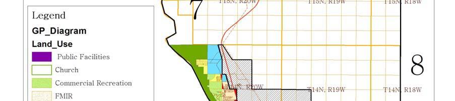
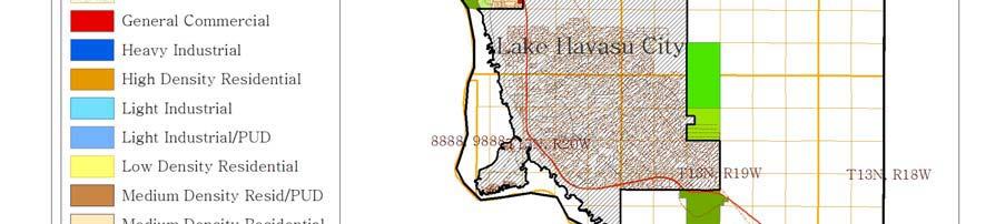
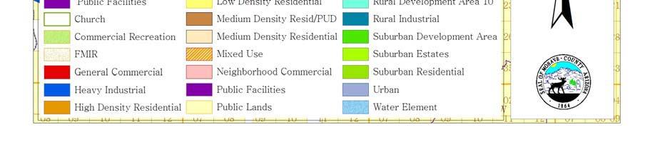
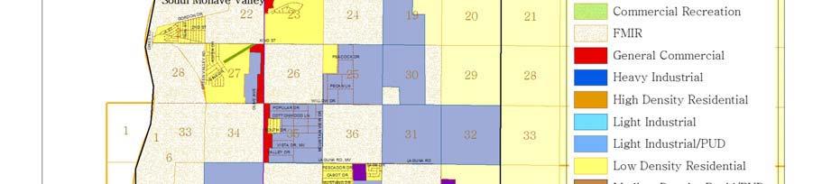
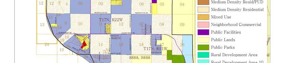
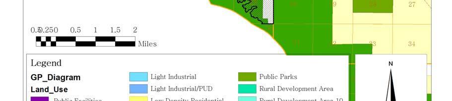
11 Exhibit VI.13: Land Use Categories in Planning Areas Residential Uses Land Use Categories RDA SDA UDA Outlying Communities Rural Residential (RR) Y M M Y Suburban Estates (SE) N Y M M Suburban Residential (SR) N Y M M Low Density Residential (LR) N N Y M Medium Density Residential (MR) N N Y M High Density Residential (HR) N N Y N Non-Residential Uses Neighborhood Commercial (NC) M M Y Y General Commercial (GC) N M Y M Commercial Recreation (CR) M M Y M Public Lands Rural Industrial (RI) Y NA NA M Light Industrial (LI) M M Y M Heavy Industrial (HI) M M Y N Airport Industrial (AI) M M Y N Public Facilities & Institutions (PF) M Y Y Y Public Parks (PP) Y Y Y Y Public Lands (PL) Y Y Y Y Y = Land use category is consistent with this planning area. M = Land use category may be consistent with this planning area, depending on the location, natural features and surrounding uses. N = Land use category is not typically consistent with this planning area. NA = Not Applicable -73-
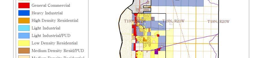
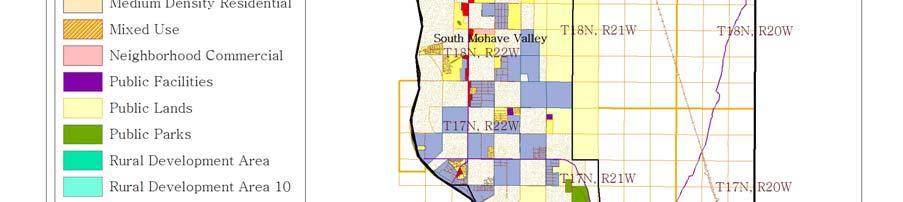
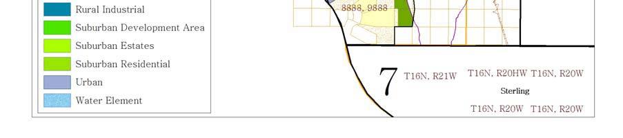
12 Exhibit VI.14: Detailed Land Use Categories for Unincorporated Mohave County Code Designation Typical(1) Density/Intensity Maximum Density Policy Intent(2) Residential RR Rural Residential 0.2 DU/A Single family dwellings on large parcels in rural, agricultural or environmentally constrained setting SE Suburban Estates 0.4 DU/A 0.5 DU/A Single family dwellings on large semi-rural parcels SR Suburban Residential 1.0 DU/A 1.0 DU/A Single family dwellings at low density LR Low Density Residential 3.5 DU/A 5 DU/A Single family dwellings on standard to large urban lots MR Medium Density Residential 8 DU/A 12 DU/A Predominantly low density apartments, duplexes, cluster developments and mobile home parks HR High Density Residential 16 DU/A 25 DU/A Apartments and condominiums Non-Residential NC Neighborhood Commercial NA NA Small scale retail and service establishments meeting the needs of residents within a neighborhood GC General Commercial NA NA Retail, office and service uses meeting community or regional needs CR Commercial Recreation NA NA Privately-owned facilities providing outdoor recreational opportunities RI Rural Industrial NA NA Includes a variety of industrial activities located in rural areas, although primarily along arterial roadways LI Light Industrial NA NA Includes low intensity manufacturing and warehousing with limited outdoor activity HI Heavy Industrial NA NA Includes uses such as construction yards, heavy manufacturing, factories and operations involving significant outside production or transfer of goods AI Airport Industrial NA NA Includes uses that are compatible with, and benefit from airport adjacency Public Land PF Public Facilities & Institutions NA NA Includes schools, fire stations, libraries, hospitals and other public buildings PP Public Parks NA NA Publicly-owned parks and open space PL Public Lands NA NA Publicly-owned lands that are not designated for park or open space uses Notes NA: Not Applicable (1) Typical - Those densities which are likely to be achieved through normal development. (2) This chart highlights primary uses anticipated in each category; the detailed descriptions of land use categories on this page provide detailed explanations. -74-
13 Exhibit VI.15: Calculation of Residential Development Density Residential Density Measured as Dwelling Units per Acre (DU/A): DU/A = For Example: Number of Dwelling Units Number of Gross Acres in Site DU/A = 100 Dwelling Units = 50 Gross Acres 2 DU/A Residential Land Uses Residential land use categories are used to identify places where the principal planned land use is for residential purposes. 15 There are six residential land use categories. The rural residential category applies to most land within Rural Development Areas (RDA's). The two suburban residential land use categories (Suburban Residential and Suburban Estate) have higher densities, and will generally have higher service requirements than rural development. However, suburban residential development in UDA's may be required to provide urban levels of service. Three of the residential categories (Low Density Residential, Medium Density Residential & High Density Residential) reflect urban residential development. Urban residential development means that lots are smaller than one acre in size and that urban services (i.e., paved roads, centralized water and sewer, etc.) must be provided to serve the development. Urban residential uses are planned only within identified Urban Development Areas; a plan amendment will be required to establish urban development in rural or suburban development areas. Rural Residential (RR). All RDA's are designated Rural Residential, permitting single family development on lots of five (5) or more acres. Larger lot sizes may be appropriate to address environmental concerns (such as steep slopes, flood hazard zones, etc.) and infrastructure deficits (such as unimproved and un-maintained roads). The existing rural/agricultural character of these areas should be maintained. Residents in these areas are able to keep their own livestock. Land use may be served by septic systems, wells, and other services planned at rural levels. Nonresidential land uses may be permitted in rural residential areas through the rezoning process. Outlying communities, typically found within these the rural parts of the county, will be permitted to continue growing at existing intensities, with uses which are consistent with, or will enhance, the existing character of the community. Suburban Estates (SE). This suburban land use is characterized by single-family lots ranging from two (2) to five (5) acres. It is a category used in the Suburban Development Areas (SDA's). Non-residential land uses are not the primary uses in a Suburban Estate area. Septic systems will be the primary means of wastewater disposal. Many lots will use well water, but this will vary based on groundwater conditions and proximity to existing organized water systems. 15 Zoning district regulations determine what additional uses may be allowed within a primarily residential area. These land uses typically include public facilities, parks and supporting commercial. -75-
14 Suburban Residential (SR). This is the highest density non-urban land use category, with densities ranging from greater than one-half (0.5) dwelling unit per acre to a maximum density of one (1) dwelling unit per acre. These densities result in lot sizes of one to two acres. While Suburban Residential areas will be mostly singlefamily, some neighborhood commercial development will be permitted as part of a planned development. Suburban service requirements generally will be lower than in urban areas, but will vary as dictated by site conditions. Septic tanks will generally be permitted, but soil conditions, groundwater quality concerns, proximity to existing utilities and other factors may create the need for urban sewer systems. Minimum road or water system improvement requirements may also vary from one site to the next. Low Density Residential (LR). This is the lowest density residential development planned within urban areas. It is designed to reflect development between one (1) and five (5) units per acre. This category is used only in Urban Development Areas (UDA's). Since the lot sizes are less than one acre, community sewer or ADEQ approved onsite sewage disposal and water systems are needed, as are other urban services. 16 Low density residential areas will be developed exclusively with single family homes, except where planned developments permitting neighborhood commercial uses are approved. Medium Density Residential (MR). This urban land use category is used to show areas with five (5) or more dwelling units per acre, but less than twelve (12) dwellings per acre. Typical residential uses in these areas are patio and zero lot line homes, mobile home parks, mobile home subdivisions, duplexes, some multi-family projects, and, where specifically approved as part of a planned development, neighborhood commercial development. Full urban services are required for medium density residential development. High Density Residential (HR). This urban residential category is used to show the highest density planned in Mohave County. Development could range from twelve (12) to a maximum of twenty-five (25) dwelling units per acre. Higher density areas provide opportunities to develop uses such as townhomes, apartments or condominiums. Mixed use developments incorporating office and retail space may be approved in HR areas through the planned development process. High Density Residential uses can serve as an effective buffer between non-residential development and lower density residential neighborhoods. Full urban services are required for HR development. Non-Residential Land Uses Non-residential land use categories are used to identify places where the principal uses are for nonresidential purposes, such as office, retail, resorts, manufacturing, and others. There are six nonresidential land use categories. All will be permitted within urban areas depending upon urban setting and availability of services. The categories are listed in Exhibits VI.13 and VI.14 and are described in more detail below. Exhibit VI.14 describes the typical uses expected in each of these categories. The uses shown here are intended to describe the general character of development. Zoning districts, consistent with these general categories, will establish the specific uses and 16 New subdivisions approved by the County with lots less than in one-acre size must be connected to a community sewer system. -76-
15 development standards for a particular non-residential property. Neighborhood Commercial (NC). Neighborhood commercial uses are those that meet the needs of residents in the adjacent neighborhood. Small scale retail and service establishments, as well as small office buildings, will be permitted in this land use category. General Commercial (GC). This land use category is used to indicate locations for retail, service and office uses that serve an entire community or region. Major retail centers, fast food restaurants, service stations, multi-story office buildings and other intensive commercial uses should be located in areas designated for general commercial uses. Commercial Recreation (CR). This land use category encompasses a broad range of privately-owned or leased facilities for active recreation, where the primary activity occurs outside of buildings. Uses include golf courses, equestrian centers, small and large scale amusement parks, as well as recreational vehicle parks and campgrounds providing sites for temporary habitation. Rural Industrial (RI). This land use category provides for industrial activities in rural areas. Uses found in Sections 11 and 21 of the North American Industrial Classification System (NAICS), such as timber harvesting and sand and gravel mining, respectively, are considered rural industrial. Rural Industrial is also an appropriate land use for renewable power generation (NAICS Section ). Section X, Appendix K for NAICS listings. Light Industrial (LI). This land use category is intended for a variety of lighter industrial uses. These uses typically involve fewer impacts on the surrounding areas, in terms of noise, fumes, nuisances and hazards, than do the uses described under Heavy Industrial. This category includes such uses as warehousing, wholesale sales and distribution, and light manufacturing. Some related office uses also occur in this category. Most activities associated with uses in this category take place within buildings. Certain construction and manufacturing activities found in Sections 23, 31, 32 and 33 of the NAICS are allowed in this land use category. Heavy Industrial (HI). This land use category allows for a relatively wide range of industrial uses, including heavy manufacturing, construction yards and support retail commercial. These uses may have safety, nuisance or environmental effects which make them undesirable neighbors to residential areas. They should be located near or adjacent to major transportation facilities (such as rail lines, airports or freeways). Design standards focus on minimizing the effects of these uses on surrounding development. Power generation, construction and manufacturing activities found in Sections 22, 23, 31, 32 and 33 of the NAICS are allowed in this land use category. Airport Industrial (AI). This land use category is intended for industrial development that is compatible with adjacent airport use and development that benefits from proximity to airport facilities. Such uses include certain manufacturers, transport service providers, wholesalers and warehouse facilities. -77-
16 Public Land Uses Public land use categories are used to identify land that is owned by the Federal, State or local government. Public land may be used for facilities ranging from libraries to wastewater treatment plants, for parks and open space, or for other public purposes. On occasion, public lands are sold or exchanged to consolidate blocks of developable land and preserve natural resource areas. All publicly owned lands fall into one of the three broad categories described below. Public Facilities (PF). This category includes such public and quasi-public institutional uses as schools, colleges, fire stations, libraries, government buildings and hospitals. Public Parks (PP). Local, State and National parks that are publicly owned and managed for the benefit of the general public are included in this category. Public Lands (PL). This category is used to indicate land in rural areas that is owned by a public agency, but is not primarily devoted to parks and recreational use. Lands owned and managed by the BLM, BoR and Arizona State Lands Department are included in this category. The Land Use Element contains special policies for the County's involvement in more intense development of these properties. Certain public lands under the administration of the BLM have also been designated for renewable energy production. Countywide Land Use Goals and Policies Community Balance Goal 10: To retain the beauty, the natural setting and resources, and the rural character of the County while providing opportunities for coordinated growth and development. Policy 10.1 Mohave County shall establish and maintain its land use plans to provide areas for different types of future land uses and intensities, and shall plan for public services and facilities appropriate to the planned land uses. Policy 10.2 Mohave County shall plan for urban, suburban and rural development areas. Policy 10.3 Mohave County should identify sufficient locations for residential and nonresidential development to accommodate growth anticipated through the year 2025, with provision of additional land use capacity for market choice and flexibility. Policy 10.4 Locations for commercial and industrial uses should be identified to support the County's economic development objectives, including diversification of the economic base. Policy 10.5 Mohave County shall use its planning and development regulations to protect residential neighborhoods from encroachment of incompatible activities or land uses which may have a negative impact on the residential living environment. -78-
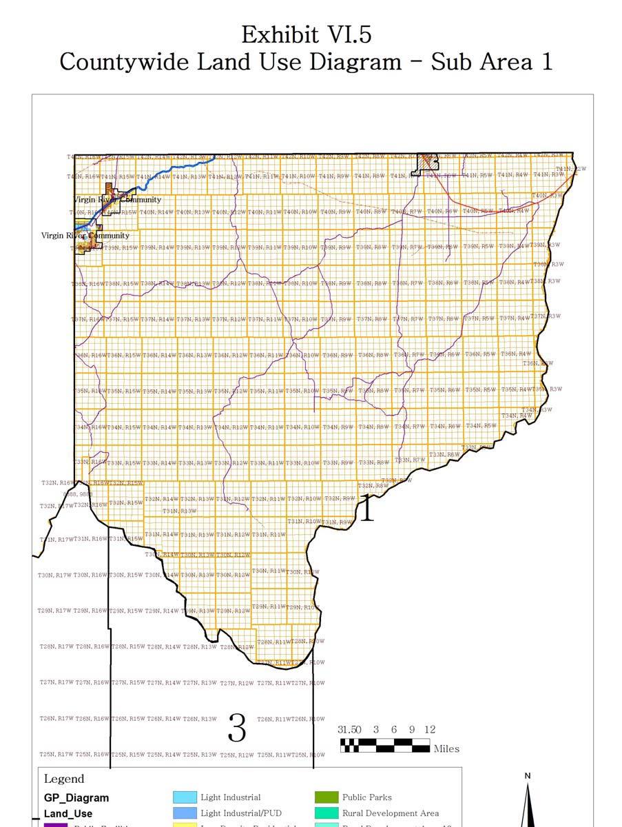
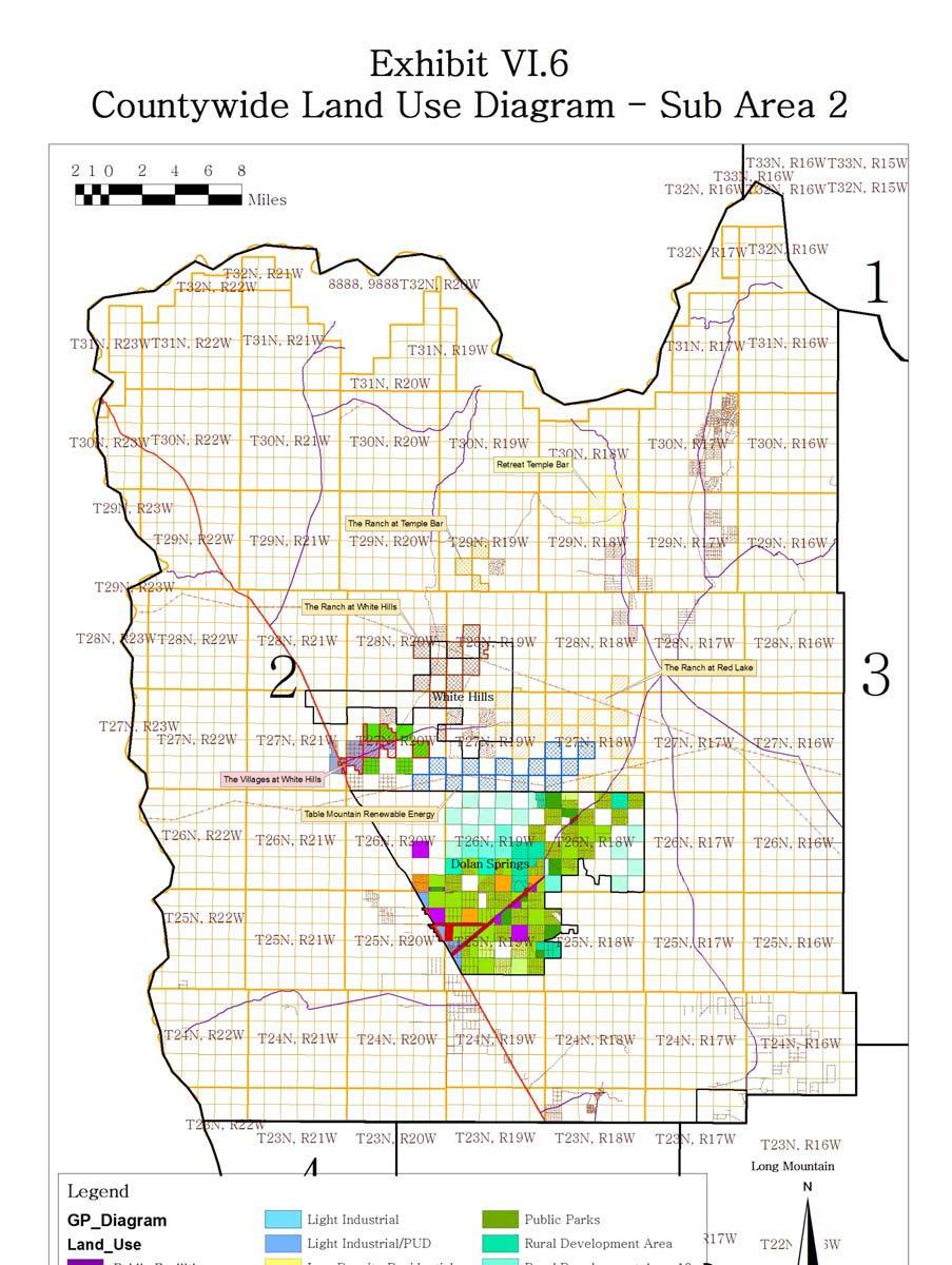
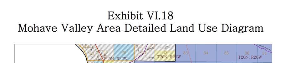
17 Policy 10.6 Proposed non-residential structures adjacent to residential neighborhoods shall be designed and located to protect the privacy of residences. Policy 10.7 Development adjacent to a park or public open space should be designed to facilitate public access to, and use of, the park while minimizing potential conflicts between park users and residents of the development. Policy 10.8 In reviewing development proposals, Mohave County should consider issues of community character, compatibility of use, environmental impact, resident security and safety, and efficient service provision. Policy 10.9 Mohave County shall require phased commercial and industrial projects to be designed so a project is able to function effectively as each phase is completed. Policy The County shall encourage future patterns of development and land use that reduce infrastructure construction costs and make efficient use of existing and planned public facilities. Policy In planning for expansion of its growth areas, Mohave County should give first priority to development of vacant or under-utilized land within these growth areas and second priority to development that expands the community. Designation of Planning and Land Use Areas Goal 11: To use the General Plan Land Use Diagram to graphically depict the County's desired community form and character. Policy 11.1 The Land Use Diagrams depict planned land use in the unincorporated areas of Mohave County. These diagrams are Exhibits VI.4 through VI.12 and Exhibits VI.16 through VI.19. These diagrams should establish the general pattern of future land use appropriate to achieve the County's goals. Policy 11.2 The official copies of the Land Use Diagrams are on file at the Mohave County Planning Department. The boundaries of land use categories, as depicted on these official diagrams, should be used to determine the appropriate land use category for areas that are not clearly delineated on the Land Use Diagrams contained in the General Plan document. Due to their size, the Land Use Diagrams reproduced in the General Plan document may not completely reflect the official copy. Policy 11.3 Exhibit VI.3 lists the general planning area types used in planning for future development in Mohave County. Mohave County shall use these planning area types to describe the general policies appropriate to particular parts of the unincorporated County. -79-
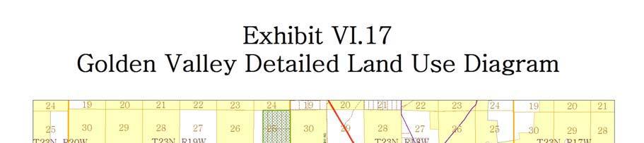
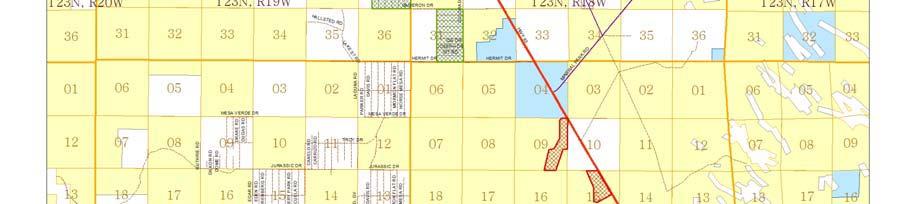
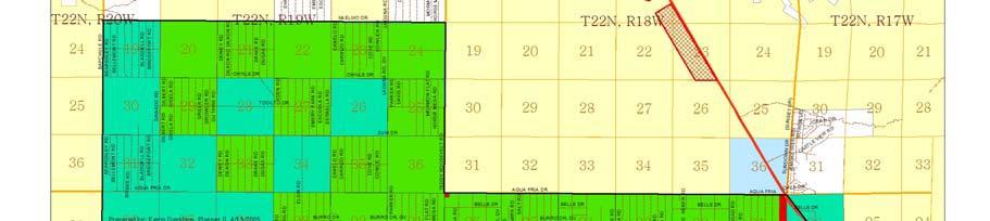
18 Policy 11.4 Exhibit VI.4 is the Countywide Land Use Diagram. It shows the location of areas planned for urban, suburban or rural development; it also shows the outlying communities subject to special planning policies. Exhibits VI.5 through VI.12 show these planning areas for each part of Mohave County. Mohave County should use these exhibits and the policies in this Land Use Element to establish the general pattern of development in the County's unincorporated areas. Zoning of individual parcels may continue to be more restrictive than the land use categories shown on the Land Use Diagram. Existing conditions, such as environmental or public facility constraints, may prevent the realization of the maximum development potential permitted in the designated land use category. Policy 11.5 Exhibits VI.13 and VI.14 provide the general description of the land use categories used in the County's Detailed Land Use Diagrams. These exhibits, along with the descriptions of these categories found in the Land Use Element text, shall explain the purpose and intent of the land use categories shown on the Detailed Land Use Diagrams. Policy 11.6 Exhibits VI.16 through VI.19 are the Detailed Land Use Diagrams for areas of the unincorporated County with substantial amounts of planned urban or suburban development. Mohave County should use these exhibits and the policies in this Land Use Element to establish the pattern of land uses and residential densities in the County's unincorporated areas. Policy 11.7 Mohave County shall only approve requests for rezoning, special permits, the division of land, other new development proposals or public projects that are consistent with these Land Use Diagrams, the policies contained in this Land Use Element and the other Elements of this General Plan, as further set forth in the County's Development Regulations. Amendments to specific area plans or the general plan may accommodate other requests. Policy 11.8 A residential proposal's density shall be considered consistent with the applicable Land Use Diagram if the average gross density of the entire project is within the range of the land use category for the property. Mohave County may approve projects at any density within this range, if consistent with zoning regulations; the category does not ensure approval at the maximum density. The actual density approved will take into consideration the policies found in the other elements of the General Plan. Appropriate infrastructure must either exist or be provided by the developer to fulfill the goals and policies within the Public Infrastructure Element. Land within a floodway should be excluded from density calculations. Floodway fringe lands may be included in the calculation if development can be appropriately engineered. -80-
19 81
20 82

21 83
22 84
4.2 LAND USE INTRODUCTION
 4.2 LAND USE INTRODUCTION This section of the EIR addresses potential impacts from the Fresno County General Plan Update on land use in two general areas: land use compatibility and plan consistency. Under
City of Sacramento Zoning Code - Zoning Descriptions Excerpt from website on April 5, 2010
 City of Sacramento Zoning Code - Zoning Descriptions Excerpt from website on April 5, 2010 RE Rural Estates Zone. This is a very low density residential zone. It is intended to be applied primarily to
891941, , : COMPREHENSIVE PLAN AMENDMENT, COMMUNITY PLAN AMENDMENT, AND AREA-WIDE MAP AMENDMENT
 Application Nos. 891941, 891909, 891940: COMPREHENSIVE PLAN AMENDMENT, COMMUNITY PLAN AMENDMENT, AND AREA-WIDE MAP AMENDMENT Amendments to designate five parcels as Rural Industrial Center in the Alderton
Chapter 2 Land Use. State of Land Use
 Ch2 6/21/2016 1 Chapter 2 Land Use The responsibility of a municipality to manage and regulate land use is rooted in its need to protect the health, safety, and welfare of local citizens. Although only
Bylaw No The Corman Park Saskatoon Planning District Official Community Plan Bylaw, 2010
 Bylaw No. 8844 The Corman Park Saskatoon Planning District Official Community Plan Bylaw, 2010 Codified to Bylaw No. 9446 May 23, 2017 BYLAW NO. 8844 The Corman Park Saskatoon Planning District Official
Corman Park - Saskatoon Planning District Official Community Plan
 1 Corman Park - Saskatoon Planning District Official Community Plan CONSOLIDATED: October, 2017 2 Table of Contents Bylaw Amendments... 3 Section 1: Foundations... 4 Section 2: Future Growth Sector Objectives
Comprehensive Plan 2015 to 2030 STATE OF LAND USE
 Chapter 2 Land Use The responsibility of a municipality to manage and regulate land use is rooted in its need to protect the health, safety, and welfare of local citizens. Although only acting as one section
PLANNING COMMISSION REPORT Regular Agenda Public Hearing Item
 PC Staff Report 11/12/12 Item No. 2B- 1 PLANNING COMMISSION REPORT Regular Agenda Public Hearing Item ITEM NO. 2B: A TO GPI; 110 ACRES; E OF K-10 & N OF W 6 TH ST (MKM) : Consider a request to rezone approximately
2030 General Plan. December 6, 7 pm
 2030 General Plan GPAC Meeting #9 GPAC Meeting #9 December 6, 7 pm City Council Input on Working Draft Land Use Map Council discussed GPAC & PC versions of the working draft land use map 11/28 Council
8Land Use. The Land Use Plan consists of the following elements:
 8Land Use 1. Introduction The Land Use Plan consists of the following elements: 1. Introduction 2. Existing Conditions 3. Opportunities for Redevelopment 4. Land Use Projections 5. Future Land Use Policies
THE CITY OF RAYMORE, MISSOURI Single-Family Residential Zoning Districts
 THE CITY OF RAYMORE, MISSOURI Single-Family Residential Zoning Districts REGULATIONS COMMON TO ALL DISTRICTS: Uses permitted in each district include detached single-family dwellings, manufactured homes
Marion County Board of County Commissioners
 Marion County Board of County Commissioners Date: 12/29/2015 P&Z: 12/28/2015 BCC: 1/12/2016 Item Number 160113Z Type of Application Rezoning Request From: A-1 (General Agriculture) To: PUD (Planned Unit
ARTICLE III District Regulations. A map entitled "Franklin Zoning Map" is hereby adopted as part of this chapter 1.
 ARTICLE III District Regulations ~ 305-8. Adoption of Zoning Map. A map entitled "Franklin Zoning Map" is hereby adopted as part of this chapter 1. ~ 305-9. Official Zoning Map; amendments. Regardless
Rural Living (RL) Rural Living
 Rural Living") Place Types Rural Living (RL) Rural Living Rural living areas are characterized by very large lots, abundant open space, pastoral views, and a highdegree of separation between buildings. The lots are typically
Place Types Rural Living (RL) Rural Living Rural living areas are characterized by very large lots, abundant open space, pastoral views, and a highdegree of separation between buildings. The lots are typically
South of White Rock Rezoning Kick-off Meeting
 South of White Rock Rezoning Kick-off Meeting May 6, 2010, 2:00 P.M. American River Room Overview Property owners seeking to restore previous zoning designations City now completing map revisions (north
Exhibit B RESOLUTION NO.
 Exhibit B RESOLUTION NO. RESOLUTION OF THE CITY COUNCIL OF THE CITY OF PLACERVILLE AMENDING THE PLACERVILLE GENERAL PLAN LAND USE SECTION - PART I: LAND USE/CIRCULATION DIAGRAMS; AMENDING THE GENERAL PLAN
Chapter Four Growth in the Next 20 years
 Chapter Four Growth in the Next 20 years Although the city of Fargo has pushed to the limits planned for in the original growth plan, the city still has substantial amounts of land available for growth.
Revised Code of Ordinances, City of Hallowell (1997) SUBCHAPTER II RESIDENTIAL DISTRICTS DIVISION A (RESERVED)
 SUBCHAPTER II RESIDENTIAL DISTRICTS DIVISION A (RESERVED)") SUBCHAPTER II RESIDENTIAL DISTRICTS DIVISION A (RESERVED) [Derivation: Ord. No. 12-10, eff. 10/19/2012] SECTIONS 9-211 THROUGH 9-230 (Reserved) DIVISION B MEDIUM DENSITY RESIDENTIAL DISTRICT (R1) SECTION
SUBCHAPTER II RESIDENTIAL DISTRICTS DIVISION A (RESERVED) [Derivation: Ord. No. 12-10, eff. 10/19/2012] SECTIONS 9-211 THROUGH 9-230 (Reserved) DIVISION B MEDIUM DENSITY RESIDENTIAL DISTRICT (R1) SECTION
Residential Project Convenience Facilities
 Standards for Specific Land Uses 35.42.220 E. Findings. The review authority shall approve a Land Use Permit in compliance with Subsection 35.82.110.E (Findings required for approval) or a Conditional
FUTURE LAND USE ELEMENT
 FUTURE LAND USE ELEMENT GOAL: 2.1 A distribution of land uses throughout unincorporated Manatee County which limit urban sprawl, providing a predictable and functional urban form, encouraging development
Section 2: Land Use Designations
 Section 2: Land Use Designations Introduction The purpose of a land use designation is to match the lands in a Plan Area to the goals, objectives and policies set out in the Official Community Plan. The
Midwest City, Oklahoma Zoning Ordinance
 2010 Midwest City, Oklahoma Zoning Ordinance 9/2/2010 Table of Contents Section 1. General Provisions... 5 1.1. Citation... 5 1.2. Authority... 5 1.3. Purpose... 5 1.4. Nature and Application... 5 1.5.
SECTION 3. Housing. Appendix A LAND USE DEFINITIONS
 SECTION 3 Housing A Appendix A LAND USE DEFINITIONS A-2 Housing Commission Attachment B Appendix A Land Use Definitions INTRODUCTION The Land Use Map (Figure A-1) of Community Vision 2040 illustrates the
Chapter RESIDENTIAL ZONING DISTRICTS
 Chapter 18.16 RESIDENTIAL ZONING DISTRICTS Sections: 18.16.010 Purpose of Chapter 18.16.020 Purpose of Residential Zoning Districts 18.16.030 Regulations for Residential Zoning Districts 18.16.040 Residential
LAND USE. General Plan Update Working Paper January In this Working Paper. Page
 General Plan Update Working Paper January 2008 In this Working Paper Page Introduction... LU-1 Distribution of Existing Land Uses... LU-1 Current General Plan Designations... LU-5 Westover Field Airport
REZONING APPLICATION INSTRUCTIONS
 REZONING APPLICATION INSTRUCTIONS All required information, as stated on the Rezoning Application Checklist, must be included to qualify as a complete application. Upon receipt, staff will review the application
Proposed Future Land Use Plan Open House
 City of Port August Aransas, 30 th, 2006 Texas Proposed Future Plan Open House Wednesday, Background The City of Port Aransas does not have an adopted Future Plan (FLUP). The last Future Plan for the City
MISSOULA COUNTY ZONING REGULATIONS Effective April 11, Chapter 2 Zoning Districts
 MISSOULA COUNTY ZONING REGULATIONS Effective April 11, 2017 Chapter 2 Zoning Districts 25 26 MISSOULA COUNTY ZONING REGULATIONS Effective April 11, 2017 SECTION 2.01 PURPOSES CHAPTER 2 ZONING DISTRICTS
ZONING CLASSIFICATION SUMMARY SHEET
 Growth and Resource Management Planning and Development Services 123 West Indiana Avenue Room 202 DeLand, Florida 32720-4253 Telephone (386) 943-7059 Fax (386) 626-6570 www.volusia.org ZONING CLASSIFICATION
ARTICLE 3: Zone Districts
 ARTICLE 3: Zone Districts... 3-1 17.3.1: General...3-1 17.3.1.1: Purpose and Intent... 3-1 17.3.2: Districts and Maps...3-1 17.3.2.1: Applicability... 3-1 17.3.2.2: Creation of Districts... 3-1 17.3.2.3:
STAFF REPORT. Permit Number: Gonzalez. Kitsap County Board of Commissioners; Kitsap County Planning Commission
 STAFF REPORT Permit Number: 15 00657 Gonzalez DATE: March 2, 2016 TO: FROM: Kitsap County Board of Commissioners; Kitsap County Planning Commission Katrina Knutson, AICP, Senior Planner, DCD and Jeff Arango,
CHAPTER 50 LAND USE ZONES ARTICLE 50 BASIC PROVISIONS
 CHAPTER 50 LAND USE ZONES ARTICLE 50 BASIC PROVISIONS 50.010 - PURPOSE The purposes of this chapter are to establish land use zones required to implement the goals and policies of the Klamath County Comprehensive
FUTURE LAND USE ELEMENT
 FUTURE LAND USE ELEMENT GOAL: 2.1 A distribution of land uses throughout unincorporated Manatee County which limit urban sprawl, providing a predictable and functional urban form, encouraging development
WOODLAND AREA GENERAL PLAN URBAN DEVELOPMENT POLICY
 APPENDIX A WOODLAND AREA GENERAL PLAN URBAN DEVELOPMENT POLICY The following text indicates proposed amendments to the Woodland Area General Plan Urban Development Policy currently adopted and included
Planning Department Oconee County, Georgia
 Planning Department Oconee County, Georgia STAFF REPORT REZONE CASE #: 6985 DATE: October 31, 2016 STAFF REPORT BY: Andrew C. Stern, Planner APPLICANT NAME: Williams & Associates, Land Planners PC PROPERTY
CCC XXX Rural Neighborhood Conservation (NC)
") CCC 33.10.XXX Rural Neighborhood Conservation (NC) Purpose: Maintain low density rural residential areas and associated uses commonly found in rural areas consistent with the local character of the distinctive
CCC 33.10.XXX Rural Neighborhood Conservation (NC) Purpose: Maintain low density rural residential areas and associated uses commonly found in rural areas consistent with the local character of the distinctive
(B) On lots less than 1.5 acres, accessory buildings shall have a maximum size of 672 square feet in area.
 On lots less than 1.5 acres, accessory buildings shall have a maximum size of 672 square feet in area.") Setbacks in Commercial Districts: (1) Downtown Business District: Setbacks from State Highways 70 and 155 shall be the lesser of a minimum of 100 feet or the footprint of the present principal building
Setbacks in Commercial Districts: (1) Downtown Business District: Setbacks from State Highways 70 and 155 shall be the lesser of a minimum of 100 feet or the footprint of the present principal building
JEFFERSON COUNTY, WEST VIRGINIA Office of Planning and Zoning 116 East Washington Street, 2 nd Floor P.O. Box 716 Charles Town, WV 25414
 JEFFERSON COUNTY, WEST VIRGINIA Office of Planning and Zoning 116 East Washington Street, 2 nd Floor P.O. Box 716 Charles Town, WV 25414 www.jeffersoncountywv.org Email: planningdepartment@jeffersoncountywv.org
A. Location. A MRD District may be permitted throughout the County provided it meets the standards established herein.
 752. Multi-Residential District (MRD) The Multi-Residential (MRD) District is intended to provide opportunities for rural, suburban and urban density mixed-residential developments consistent with the
Chapter 1107: Zoning Districts
 Chapter 1107: Zoning Districts 1107.01 Establishment of Zoning Districts (a) Districts Established In order to carry out the purpose of this code, the City is hereby divided into the zoning districts established
1. Future Land Use FLU6.6.8 Land uses within the Rural Service Area portion of the Wekiva Study Area shall be limited to very low and low intensity
 1. Future Land Use FLU6.6.8 Land uses within the Rural Service Area portion of the Wekiva Study Area shall be limited to very low and low intensity uses to the greatest extent possible. Existing land uses
PUTNAM COUNTYCOMPREHENSIVE PLAN
 COMPREHENSIVE PLAN EXHIBIT AA COMPREHENSIVE PLAN A. Future Land Use Element Goals, Objectives, Policies This section proposed objectives and policies, which will assist Putnam County Commissioners and
North Qu Appelle No. 187 Bylaw Basic Planning Statement - Table of Contents
 - Table of Contents Section1 Introduction 2 Section 2 - The Rural Municipality of North Qu Appelle No. 187 3 Section 3 Municipal Goals.... 3 Section 4 Agriculture and Natural Resources.. 4 Section 5 Residential
CITY OF NORTH LAS VEGAS MEMORANDUM
 CITY OF NORTH LAS VEGAS MEMORANDUM TO: FROM: SUBJECT: Planning Commission Community Development and Compliance Department # 28 ) AMP-03-15; Coleman Airpark II & III - Comprehensive Plan Amendment (Public
Existing Land Use. Typical densities for single-family detached residential development in Cumberland County: 1
 Existing Land Use A description of existing land use in Cumberland County is fundamental to understanding the character of the County and its development related issues. Economic factors, development trends,
Land Use Survey Summer 2014
 Land Use Survey Summer 2014 North Ogden City, Utah Robert Scott, City Planner Travis Lund, Planning Intern Contents General Information... 1 Land Use Groups... 1 Urbanized Land Uses... 1 Residential...
HOUSING ELEMENT GOALS, OBJECTIVES, & POLICIES
 HOUSING ELEMENT GOALS, OBJECTIVES, & POLICIES GOAL H-1: ENSURE THE PROVISION OF SAFE, AFFORDABLE, AND ADEQUATE HOUSING FOR ALL CURRENT AND FUTURE RESIDENTS OF WALTON COUNTY. Objective H-1.1: Develop a
PUBLIC DRAFT May 2017 Zoning Districts Use Regulations Definitions (partial)
") PUBLIC DRAFT May 2017 Zoning Districts Use Regulations Definitions (partial) Table of Contents Subchapter 1: General Provisions... 1 Subchapter 2: Administration & Procedures... 3 Subchapter 3: Zoning
PUBLIC DRAFT May 2017 Zoning Districts Use Regulations Definitions (partial) Table of Contents Subchapter 1: General Provisions... 1 Subchapter 2: Administration & Procedures... 3 Subchapter 3: Zoning
SECTION CLASSIFICATION OF ZONES For the purpose of this Code the following primary land use zoning districts are hereby established:
 ARTICLE 4 ZONING DISTRICTS SECTION 4.010 CLASSIFICATION OF ZONES For the purpose of this Code the following primary land use zoning districts are hereby established: Primary Zones Abbreviated Designation
STAFF REPORT. Permit Number: Unlimited. Kitsap County Board of Commissioners; Kitsap County Planning Commission
 STAFF REPORT Permit Number: 15 00550 Unlimited DATE: March 2, 2016 TO: FROM: Kitsap County Board of Commissioners; Kitsap County Planning Commission Katrina Knutson, AICP, Senior Planner, DCD and Jeff
ADAMS COUNTY, NEBRASKA
 ADAMS COUNTY, NEBRASKA LAND USE PLAN 2010 AMENDED AND ADOPTED BY ADAMS COUNTY, NEBRASKA AUGUST 3, 2010 RESOLUTION NO. 10-08-03.1 Prepared By 1 EXISTING LAND USE INTRODUCTION Evaluating the land uses that
2. LAND USE DESIGNATIONS AND PRINCIPLES FOR DEVELOPMENT
 2. LAND USE DESIGNATIONS AND PRINCIPLES FOR DEVELOPMENT General areas have been designated for specific types of land use on the Future Land Use Map and are described in this section. In order to satisfy
GOVERNMENT CODE SECTION GOVERNMENT CODE SECTION 65302
 GOVERNMENT CODE SECTION 65300 65300. Each planning agency shall prepare and the legislative body of each county and city shall adopt a comprehensive, long-term general plan for the physical development
ARTICLE B ZONING DISTRICTS
 ARTICLE B ZONING DISTRICTS Sec. 8-3021 Established. In order to protect the character of existing neighborhoods; to prevent excessive density of population in areas which are not adequately served with
H5. Residential Mixed Housing Urban Zone
 H5. Residential Mixed Housing Urban Zone H5.1. Zone description The Residential Mixed Housing Urban Zone is a reasonably high-intensity zone enabling a greater intensity of development than previously
301. Zoning Districts. C-D A-1 R-1 R-V B-1 I-1
 301. Zoning Districts. The Township is divided into the districts set forth by this chapter and as shown by the district boundaries on the Official Zoning District Map. The zoning districts are: C-D Conservation
DIVISION 1 PURPOSE OF DISTRICTS
 ARTICLE 2 ZONING DISTRICTS AND MAP DIVISION 1 PURPOSE OF DISTRICTS Section 2.101 Zoning Districts. For the purpose of this Ordinance, the City of Richmond is hereby divided into districts as follows: DISTRICT
RE: 6. GILL/GREEN COMPREHENSIVE PLAN AMENDMENT, REZONING AND PRELIMINARY PLAT
 commission memo DATE: Thursday - August 9, 2018 TO: Marion Planning & Zoning Commission FROM: David N. Hockett, AICP Principal Planner RE: 6. GILL/GREEN COMPREHENSIVE PLAN AMENDMENT, REZONING AND PRELIMINARY
1.2 Forecasting Growth
 Relationship to Zoning and Other Implementation Actions The Anchorage 2040 Land Use Plan, along with other elements of the Comprehensive Plan, provides policy direction for future land use decisions, such
To achieve growth, property development, redevelopment and an improved tax base in the cities and boroughs in the Lehigh Valley.
 Most growth in property valuation is in townships. Between 1991 and 2004, the assessed valuation of the townships in the Lehigh Valley increased by more than $2.8 billion, an increase of 41%. At the same
Chapter 2. Zoning Districts
 CHAPTER II. LAND USE ZONING DISTRICTS 2.00.00. GENERALLY In order to ensure that all development is consistent with the goals and objectives of the comprehensive plan, it is necessary and proper to establish
WASHINGTON COUNTY DEVELOPMENT CODE
 WASHINGTON COUNTY DEVELOPMENT CODE Pursuant to MSA Ch 394, Washington County has adopted official controls for the purposes of regulating the physical development of land in the unincorporated areas of
Division 5 Residential Low Density Zone: Assessment Criteria and Assessment Tables
 Division 5 Residential Low Density Zone: Assessment Criteria and Assessment Tables 4.5.1 Residential Low Density Zone The provisions in this division relate to the Residential Low Density Zone as follows
1 November 13, 2013 Public Hearing APPLICANT & PROPERTY OWNER: HOME ASSOCIATES OF VIRGINIA, INC.
 1 November 13, 2013 Public Hearing APPLICANT & PROPERTY OWNER: HOME ASSOCIATES OF VIRGINIA, INC. STAFF PLANNER: Carolyn A.K. Smith REQUEST: Conditional Change of Zoning (AG-1 & AG-2 Agricultural Districts
RESOLUTION NO. WHEREAS, per the 2010 U.S. Census the population of the City of Placerville was 10,389; and
 RESOLUTION NO. RESOLUTION OF THE CITY COUNCIL OF THE CITY OF PLACERVILLE AMENDING THE HIGH DENSITY RESIDENTIAL (HD) LAND USE DESIGNATION CONTAINED WITHIN THE CITY OF PLACERVILLE S GENERAL PLAN PART 1 LAND
Accessory Dwelling Units PJR-032
 Accessory Dwelling Units PJR-032 Purpose: This handout summarizes the regulations of the Sonoma County Zoning Ordinance for accessory dwelling units. The text of the ordinance is located in Attachment
2. Second dwellings and medical hardships per Article 10.
 Article 7: Zoning Districts and Zoning Map Section 135: NON-URBAN ZONING DISTRICT (NU) A. Purpose The intent of this district is to allow agricultural, recreational, wildlife, forestry, open space, farming
1.300 ZONING DISTRICT REGULATIONS
 1.205 VACANT LOT SPECIAL REQUIREMENTS: On lots less than 1.5 acres, only one garage allowed with a maximum size of 672 square feet in area. 1.300 ZONING DISTRICT REGULATIONS 1.301 ESTABLISHMENT OF DISTIRCTS:
CITY OF PORT ORCHARD
 CITY OF PORT ORCHARD ZONING DESIGNATIONS (Adapted from POMC Chapter 20.34 Zoning Districts, as adopted 6/13/2017) 20.34.110 Greenbelt zone (Gb). (1) Purpose. It is the purpose of the greenbelt zone to
Town of. River Falls. Land Use Element Vierbicher Associates, Inc
 Town of River Falls 2005 Vierbicher Associates, Inc Contents Contents s. 66.1001(2)(h) Wis. Stats................................................. ii Introduction................................................................
PAPRlamird4-Lairds Corner
 PAPRlamird4-Lairds Corner Lamird Report This report provides the written record of local circumstances that explains how the Lairds Corner LAMIRD ( this lamird ) fits within the rural element goals of
Understanding the Conditional Use Process
 Understanding the Conditional Use Process The purpose of this document is to explain the process of applying for and obtaining a conditional use permit in the rural unincorporated towns of Dane County.
Metropolitan Planning Commission. DATE: April 5, 2016
 TO: FROM: Metropolitan Planning Commission MPC Staff DATE: April 5, 2016 SUBJECT: Petition of Nine Line Inc. Robert McCorkle, Agent PIN: 2-1034-01-002 380.5 Acres Aldermanic District: 5 (Shabazz) County
ARTICLE 2 ZONING DISTRICTS AND MAPS
 ARTICLE 2 ZONING DISTRICTS AND MAPS SECTION 2.100 PURPOSE OF DISTRICTS Section 2.101. For the purpose of this Ordinance, Billings Township is hereby divided into districts as follows: DISTRICT NAME SYMBOL
STAFF REPORT. Permit Number: Porter. Kitsap County Board of Commissioners; Kitsap County Planning Commission
 STAFF REPORT Permit Number: 15 00461 Porter DATE: November 9, 2015 TO: FROM: Kitsap County Board of Commissioners; Kitsap County Planning Commission Katrina Knutson, AICP, Senior Planner, DCD and Jeff
19.12 CLUSTER RESIDENTIAL DISTRICT
 Chapter 19.12 CLUSTER RESIDENTIAL DISTRICT (Adopted 12/22/2003; Ordinance #0061970). Amended 7/3/17, Ordinance #079100. Section 19.12.010 - Declaration of Intent. The Cluster Residential District provides
3.1. OBJECTIVES FOR RESIDENTIAL LAND USE DESIGNATIONS GENERAL OBJECTIVES FOR ALL RESIDENTIAL DESIGNATIONS
 3. RESIDENTIAL LAND USE DESIGNATIONS INTRODUCTION The Residential land use designations provide for housing and other land uses that are integral to, and supportive of, a residential environment. Housing
Land Use. Land Use Categories. Chart 5.1. Nepeuskun Existing Land Use Inventory. Overview
 Land Use State Comprehensive Planning Requirements for this Chapter A compilation of objectives, policies, goals, maps and programs to guide the future development and redevelopment of public and private
PINELLAS COUNTY COMPREHENSIVE PLAN
 PINELLAS COUNTY COMPREHENSIVE PLAN Future Land Use Map (FLUM) Category Descriptions and Rules Amended March 17, 2009 (Ordinance 09-17) Amended March 16, 2010 (Ordinance 10-18) Amended October 26, 2010
2014 Plan of Conservation and Development. Development Plan & Policies
 The Town of Hebron Section 3 2014 Plan of Conservation and Development Development Plan & Policies C. Residential Districts I. Residential Land Analysis This section of the plan uses the land use and vacant
Tallahassee Land Development Code
 Tallahassee Land Development Code Sec. 10-170. Residential reservation District (a) urpose and Intent. (1) The district is characterized by existing homogeneous residential areas within the community which
City of Oshkosh Zoning Update
 City of Oshkosh Zoning Update The Zoning Rewrite Process Commenced in June of 2013 with selection of Vandewalle and Associates as zoning rewrite consultants. Consultants, City Staff, Plan Commission, and
HOOD RIVER COUNTY EXCEPTIONS DOCUMENT. (Amended 12/17/84)
") HOOD RIVER COUNTY EXCEPTIONS DOCUMENT 1984 (Amended 12/17/84) COUNTY EXCEPTIONS DOCUMENT The Hood River County Comprehensive Land Use Plan is the basic instrument used for County land use planning. It
HOOD RIVER COUNTY EXCEPTIONS DOCUMENT 1984 (Amended 12/17/84) COUNTY EXCEPTIONS DOCUMENT The Hood River County Comprehensive Land Use Plan is the basic instrument used for County land use planning. It
TABLE OF CONTENTS SECTION TITLE PAGE. 1.0 Introduction Residential Industrial 4
 TABLE OF CONTENTS SECTION TITLE PAGE 1.0 Introduction 2 2.0 Residential 3 3.0 Industrial 4 4.0 Outdoor Storage, Yards Lot Area, Frontage and Fencing 5 5.0 Implementation 6 2 1.0 INTRODUCTION On May 25,
ARTICLE 7. SPECIFIC USE STANDARDS
 ARTICLE 7. SPECIFIC USE STANDARDS Section 7.1 Applicability The following standards apply to specified uses in all zoning districts in which such uses are allowed. Section 7.2 Accessory Apartments (A)
H6 Residential Terrace Housing and Apartment Buildings Zone
 H6. Residential Terrace Housing and Apartment Buildings Zone [CIV-2016-404-002333: Franco Belgiorno-Nettis]-Note: The properties affected by this appeal are identified on the Auckland Unitary Plan viewer.
4.2 RESIDENTIAL ZONING DISTRICTS
 4.2 RESIDENTIAL ZONING DISTRICTS A. Purpose: To define regulations and standards for each residential zoning district in the City. The following sections identify uses, regulations, and performance standards
PLANNING REPORT. Lot 5, SDR Lot 6 and 7 Concession 3 Township of Normanby Municipality of West Grey County of Grey
 PLANNING REPORT Dwelling Surplus to a Farm Operation Official Plan and Zoning By-law Amendment and Consent to Sever Lot 5, SDR Lot 6 and 7 Concession 3 Township of Normanby Municipality of West Grey County
Zachary, Louisiana Unified Development Code
 Zachary, Louisiana Unified Development Code CONTENTS PAGE I CONTENTS Article 1 Zoning Districts; Uses and Accessory Uses... 1 Division 1.100 Purpose and Application of Article... 1 Sec. 1.101 Purpose
H4. Residential Mixed Housing Suburban Zone
 H4. Residential Mixed Housing Suburban Zone H4.1. Zone description The Residential Mixed Housing Suburban Zone is the most widespread residential zone covering many established suburbs and some greenfields
March 26, Sutter County Planning Commission
 March 26, 2003 To: Re: Sutter County Planning Commission Agenda Item #12: Public hearing on Rezoning #03-04 to change the zoning classification of two parcels totaling 324+ acres from the AG (General Agricultural)
Comprehensive Plan Amendment #PLN , Reserve at Cannon Branch (Coles Magisterial District)
") COUNTY OF PRINCE WILLIAM 5 County Complex Court, Prince William, Virginia 22192-9201 PLANNING (703) 792-7615 FAX (703) 792-4758 OFFICE Internet www.pwcgov.org Christopher M. Price, AICP Director of Planning
COUNTY OF PRINCE WILLIAM 5 County Complex Court, Prince William, Virginia 22192-9201 PLANNING (703) 792-7615 FAX (703) 792-4758 OFFICE Internet www.pwcgov.org Christopher M. Price, AICP Director of Planning
25282 Baseline Street, San Bernardino
 LAN FOR SALE Residential / Multi-Family / Senior or ay Care evelopment 2282 Baseline Street, San Bernardino A M RO A O ABL SAN E Baseline Street S el Rosa rive ROERTY OVERVIEW > Approximately: ±39,200
PLANNING COMMISSION STAFF REPORT
 PLANNING COMMISSION STAFF REPORT West Capitol Hill Zoning Map Amendment Petition No. PLNPCM2011-00665 Located approximately at 548 W 300 North Street, 543 W 400 North Street, and 375 N 500 West Street
FEC The purpose of the Flexible Use Employment Center classification is to provide for areas of employment uses situated on individual sites or in
 FEC The purpose of the Flexible Use Employment Center classification is to provide for areas of employment uses situated on individual sites or in campus-style parks. Primary uses in the FEC classification
THE REDEVELOPMENT PLAN
 PAGE 37 THE REDEVELOPMENT PLAN FUTURE LAND USE The Silver Terrace Redevelopment Area is currently designated as Redevelopment Area #4 on the City of Delray Beach Future Land Use Map (FLUM). This designation
ZONING ORDINANCE CITY OF GRANDVIEW
 ZONING ORDINANCE CITY OF GRANDVIEW TABLE OF CONTENTS SECTION 1 TITLE SECTION 2 PURPOSE SECTION 3 ZONING DISTRICTS ESTABLISHED 3.1 Zoning Districts Identified 3.2 Description and Purpose of Zoning Districts
ARTICLE 15 - PLANNED UNIT DEVELOPMENT
 Section 15.1 - Intent. ARTICLE 15 - PLANNED UNIT DEVELOPMENT A PUD, or Planned Unit Development, is not a District per se, but rather a set of standards that may be applied to a development type. The Planned
H5. Residential Mixed Housing Urban Zone
 H5. Residential Mixed Housing Urban Zone [ENV-2016-AKL-000197: Robert Adams] Addition sought H5.1. Zone description The Residential Mixed Housing Urban Zone is a reasonably high-intensity zone enabling
CHAPTER 2: ZONING DISTRICTS
 CHAPTER 2: ZONING DISTRICTS 2.1. GENERAL 2.1.1. Purpose To carry out the purpose and provisions of this Code, the County is divided into zoning districts. This chapter establishes the base zoning districts