Archaeological Building Survey:
|
|
|
- Maximillian Jack Matthews
- 6 years ago
- Views:
Transcription


 Ltd.")


1 Archaeological Building Survey: Worsley New Hall Cold War Bunker, Worsley. Final Version. Client: Peel Investments (North) Ltd. Technical Report: Dr Michael Nevell & Charlotte Vance Report No: 02/2012 CfAA: Archaeological Building Survey: Concrete Bunker, Worsley. January 2012 (2) Page 1
2 Contents Summary 3 1. Introduction 4 2. Historical Background 6 3. Building Description 7 4. Discussion Sources 15 Appendix 1: Photographic catalogue 17 Appendix 2: Illustrations 23 CfAA: Archaeological Building Survey: Concrete Bunker, Worsley. January 2012 (2) Page 2
3 Summary The Centre for Applied Archaeology was commissioned by Peel Investments (North) Ltd to undertake a Level 2 Building Survey of the Cold War Bunker at Worsley New Hall, Worsley, M28 2LJ. The survey work was carried out in November 2011 by Vicky Nash, Brian Grimsditch and Matthew Bishop. A concrete bunker was constructed by the War Office in 1951 as an Anti Aircraft Operations Room (AAOR). In 1958 the Bunker became redundant and was used by the Royal Navy as a food store until the early 1960s. In 1961 the Bunker was purchased by Salford Corporation and used as a joint area control centre with Lancashire County Council. However, after the disbanding of the Civil Defence Corps in 1968 the building was handed over to the Greater Manchester Fire Service and in 1985 leased a local gun club who used the site as a shooting range until 2000 when it purchased by Peel Investments (North) Ltd. The building was empty at the time of the current survey and due to extensive vandalism both entrances have now been blocked. CfAA: Archaeological Building Survey: Concrete Bunker, Worsley. January 2012 (2) Page 3
4 1. Introduction 1.1 Background The Centre for Applied Archaeology was commissioned by Peel Investments (North) Ltd to undertake a Level 2 Building Survey of the Cold War Bunker at Worsley New Hall, Worsley, M28 2LJ. The survey work was carried out in November 2011 by Vicky Nash, Brian Grimsditch and Matthew Bishop. 1.2 Location, Topography and Current Land Use A concrete bunker was constructed by the War Office in 1951 as an Anti Aircraft Operations Room (AAOR). In 1958 the Bunker became redundant and was used by the Royal Navy as a food store until the early 1960s. In 1961 the Bunker was purchased by Salford Corporation and used as a joint area control centre with Lancashire County Council. However, after the disbanding of the Civil Defence Corps in 1968 the building was handed over to the Greater Manchester Fire Service and in the early 1990s it was sold to a local gun club and used as a shooting range until The building was empty at the time of the current survey and due to extensive vandalism both entrances have now been blocked. There are no designations associated with the Bunker and it is not currently listed on the Greater Manchester Historic Environment Record. However, it does lie within the Middle Wood Site of Biological Interest (grade B). 1.3 Methodology This survey has followed the conventions laid down in Understanding Historic Buildings. A guide to good recording practice (English Heritage 2006) and the Institute of Field Archaeologists' Standard and Guidance for the archaeological investigation and recording of standing buildings or structures (IFA, Revised Edition 2001). In brief this work comprised: Historic research including a historic map regression exercise (scaled to a large, uniform, size), examination of Census records, trade directories and local history sources held at Salford Local History Library. A photographic survey showing general view of the building s exterior and setting; the overall appearance of the building s principle rooms and circulation areas; detailed coverage of the building s external and internal appearance; and architectural and structural features relevant to the building s design. The photographs have been taken as high resolution digital photographs, with the viewpoint directions shown on plans. A measured ground floor and first floor plan at 1:100 scale. CfAA: Archaeological Building Survey: Concrete Bunker, Worsley. January 2012 (2) Page 4
5 A written report including a description of the structure; a discussion of the site s development and importance; and a photographic catalogue. CfAA: Archaeological Building Survey: Concrete Bunker, Worsley. January 2012 (2) Page 5
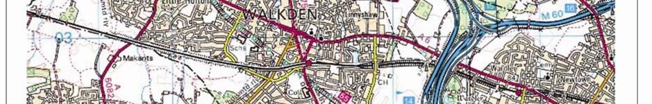
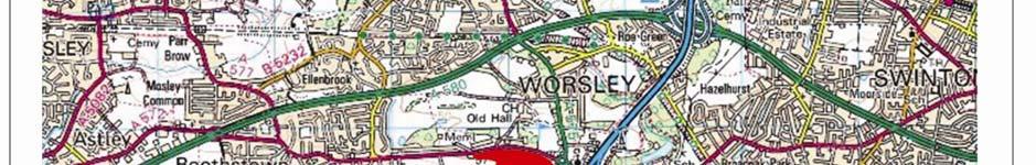
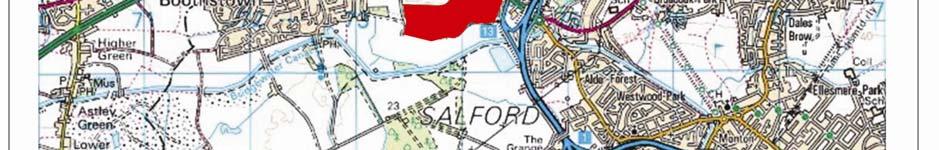
6 2. Historical Background 2.1 Introduction The background history of the Bunker was mainly uncovered from cartographic evidence although a certain amount of information was obtained from local historical sources taken from Salford University Library, Salford Local History Library, the Bridgewater Estate Archive and Census Returns. 2.2 The Cartographic Evidence The site of the concrete bunker first appears on a 1952 map from the Bridgewater Estate Archive (Fig 2). This depicts the area of the proposed bunker with its sewer and electrical services. The 1975 map (Fig 3) shows the completed bunker. It was square in shape and had a car park to the east. The bunker complex lay south of an access road. The bunker appears unaltered on the subsequent 1991 OS mapping (Fig 4) and the site survey in November 2011 determined that no alterations had taken place externally to the structure. 2.3 The Documentary Evidence Correspondence held within the Bridgewater Estate Archive, which date to June 1951, referred to the construction of a reinforced concrete building by the War Office on the site of the former New Hall (BEA/IV/C20, Vol. 844). Although the purpose of the building was not stated within this correspondence, further documentary research has established that the building was an Anti Aircraft Operations Room, which was opened in 1952 and which served the Manchester Gun Defended Area (Catford, 2002, 1). In November 1956 the site was sold by Bridgewater estates to the Secretary of State for the War Department was re-used as a Royal Navy food store until 1961, when it was purchased by Salford Corporation and used as a joint area control centre with Lancashire County Council (Catford, 2002, 1; Bridgewater Archives, Peel Group). After the disbanding of the Civil Defence Corps in 1968 the building was handed over to the Greater Manchester Fire Service. In 1985 they leased the site to the Worsley Rifle and Pistol Club who used it as a shooting range (Catford, 2002, 1; Bridgewater Archives, Peel Group). In 2000 the Bunker was purchased by Peel Investments (North) Ltd. However owing to extensive vandalism both entrances into the Bunker were blocked and the structure has remained empty ever since. This last sale re-united the site with the historic Worsley New Hall grounds. CfAA: Archaeological Building Survey: Concrete Bunker, Worsley. January 2012 (2) Page 6
7 3. Building Description 3.1 The Overall Plan-form of the Bunker This section provides a description of the standing structure of the bunker as visible at the time of the survey. It is not an architectural description, but rather an archaeological assessment of the building s fabric, space and function as recovered from measured and photographic surveys. The findings of this work are used to inform an assessment of the structure s date, phasing and importance. At the time of the current survey the Bunker was a large square, concrete, structure, two storeys high. It was terraced into the hillside. The interior was dominated by a large, central, square-plan operations room which rose through both storeys. This was surrounded by rooms accessed by corridors. 3.2 Ground Floor Entrance The ground floor was accessed via a secondary entrance which was located at this level on the southern side of the building. The entrance had been bolted and welded shut, a safety precaution likely to have been untaken by the local gun club in the 1990s. Corridor G1 (Fig 9) This room ran throughout the ground floor of the building providing access into all rooms on this level. G1 measured 1.20m wide and approximately 2.50m in height. The floor, walls and ceiling were constructed from reinforced concrete slabs. Iron piping and ventilation trunking ran round the top of the walls throughout the corridor. Room G2 (Fig 10) This room lay in the south-western corner of the building. The ceilings and walls were entirely covered in square asbestos tiles, which probably acted as a sound-proofing system. The floor was constructed from concrete. At the western end of the room were two wallmounted boxes containing possible fuse boxes. These boxes were linked to an aluminium bar also mounted on the western wall. Two ceiling lights and associated switches were located in the central portion of the room. A possible iron air vent built into the ceiling was identified in the south-western corner of the room. The sound proofing tiling indicated that this was a radio/communications room. Room G3 (Fig 11) This room lay in the south-western portion of the building. Access to G3 was from corridor G1 to the south and from the central operations room G4 to the east. The room measured CfAA: Archaeological Building Survey: Concrete Bunker, Worsley. January 2012 (2) Page 7
8 4.27m x 5.50m. The floors, ceilings and walls were constructed from reinforced concrete slabs and covered in square tiling. No other features were present in this room. Room G4 (Fig 12) This was located in the central portion of the building. G4 was the largest room in the building measuring 10.43m x 10.97m. The room had four points of access; from the west through corridor G1 and room G3 and from the east through corridor G1 and room G10. The viewing gallery (G7) located above the room to the north clearly identified this space as the main operations room. The walls, ceiling and floors were constructed from reinforced concrete slabs. Across the ceiling laid east to west were metal lighting strips and the remains of electrical cord that would have originally carried overhead lights. Strips of metal were also found on the walls (Fig 13). These were probably used as a mounting for shelves or cabinets. At least four blocked doorways were identified running around the top of G4 at first floor height. These doorways would have originally led to rooms F2 and F7 on the first floor. Two open doorways at the same height were also indentified located either side of the viewing gallery in F5. These access points infer that a spectator s gallery originally ran over or around the top of the operations room with access to both G4 and the various first floor rooms. This notion is supported by the presence of beam slots running around the circumference of the room at the same level. The room was found to be full of debris from all periods. Room G5 (no image) This room was located in western half of the building, against the western exterior wall. Originally the room would have been accessible from the north by corridor G1. At the time of this survey this access was blocked by debris. Room G6 (Fig 14) This lay in the far north-western corner of the building. The room measured 5.64m x 4.57m. The floors, walls and ceiling were constructed from concrete. Iron pipes and light fittings ran at ceiling level across the extent of the room. No other fixtures or fittings were present. G6 could be accessed from two doorways along the room s northern wall, both of which led into corridor G1. At the western end of G6, a doorway led into a narrow side room measuring 3.20m x 0.92m. The only access into this room was through G6. This side room was void of any fixtures and fittings. Room G7 (Fig 15) This room was located in the southern central portion of the building. The room measured 6.40m x 5.71m. The floor, walls and ceilings were constructed from reinforced concrete slabs. Light fittings ran at ceiling level. An air vent system ran along the top of the northern wall. A T-shaped wooden inlay ran north-south across the main floor of the room. A groove running down the centre of this wooden inlay suggested that this feature was a runner for mobile shelving or screens. Room G8 (Fig 16) This lay in the far north-eastern corner of the building, and was a mirror image of room G6. The room measured 5.64m x 4.57m. The room could be accessed from the west through a CfAA: Archaeological Building Survey: Concrete Bunker, Worsley. January 2012 (2) Page 8
9 1.52m wide doorway from corridor G1. At the eastern end of G8, a doorway led into a narrow side room. This room measured 3.20m x 0.92m. A likely use of this space would be for storage purposes. Iron heating pipes and light fittings ran around the top of the room at ceiling level. At the eastern end of the room, the remains of three wall mounted iron coat hooks (Fig 17) were found to the south of the doorway leading to the side room. Room G9 (Fig 18) This room lay in the eastern half of the building, directly opposite room G8 in the west half of the building. The room measured 5.50m x 3.05m. The only access into this room was from the north through a reinforced steel framed cast iron safe door. The door was painted gray and embellished with the maker s stamp on the inside of the door: Chatwood Milner ltd, London, England (Fig 19). Along the south wall of the room were three fitted cast iron/steel safes all of which were found to be empty and open. The eastern safe was embellished with the logo: Samuel Withers & Co, West Bromwich. To the west of the safes, along the room s western wall was one set of steel shelving units. Adjacent to these units was a four tiered grey filing cabinet which were found open and empty. Next to the filing cabinet were two blue steel cabinets. Other shelving units were found lying on the ground amongst general debris. Room G10 (Fig 20) This lay in the southeast portion of the building and was a mirror image of room G3. G10 measured 4.27m x 5.50m. The room could be accessed from the north via corridor G1 or from the west by the central operations room G4. A single strip of metal ran around the room at mid level. Light fittings and a ventilation shaft ran north-south across the room at ceiling level. The room was found to be full of debris. Room G11 (Fig 21) This room was located in the far southeast corner of the building. The room measured 3.05x 2.60m and was accessible from the north by corridor G1. In the southwest corner of the room was a cast iron/steel boiler (Fig 22). Running from the back of the boiler up and through the ceiling was a flue. Various iron pipes ran off the east side of the boiler. Fitted to the east wall of G11 were the remains of two iron supporting bars, probably used to hold machinery associated with boiler (Fig 23). Various light fitting and control switches were found mounted to the west wall of G11 under an air vent. Room G12 (Fig 24) This lay directly to the west of room G11. The room measured 4.71m x 3.06m and was accessible from the west by corridor G1. The room contained a large iron/steel air handling unit, the central component for the building s ventilation system. The controls for the system and the room s lighting were located on the western wall. An additional wall mounted control was located on the eastern wall (Fig 25). Stairwells Stairwell S1 (Fig 26) was located at the very south of the building. The stairs rose from an entrance flanked by two steel posts in corridor G1 to room F1 on the first floor. The staircase CfAA: Archaeological Building Survey: Concrete Bunker, Worsley. January 2012 (2) Page 9
10 was found to be blocked at the top of its flight by a wooden hatch laid into the floor of F1 (Fig 31) Stairwell S2 (no image) was located in the western half of the building. The stairs rose from corridor G1 on the ground floor to room F2 on the first floor. The stairs provided direct access to the viewing platform G7 on the first floor. Stairwell S3 (Fig 27) was located in the eastern half of the building. The stairs rose from corridor G1 to corridor F4 on the first floor. The stairs provided direct access to the viewing platform G7 on the first floor. Stairwell S4 (Fig 28) lay in the far northeast corner of the building. The stairs rose from corridor G1 on the ground floor to the toilet block in room F6 on the first floor. 3.3 First floor Main Entrance This was located at this level on the north side of the building and incorporates a concrete covered porch. During the time of survey the locks and bolts of the main door were vandalised and broken open. Immediately after the survey the entrance was permanently sealed with concrete. Room F1 (Fig 29) This room was located in southern part of the building. The room ran the full width of the building, along its southern external wall. F1 measured 21.70m x 4.60m. The floors, walls and ceilings were all constructed from reinforced concrete slabs. Access to F1 was from the west through a door in the northern partition wall. At the far western end of the room was a row of four shooting targets made from sheet metal. It is likely that these sheets originally lay behind superimposed circle targets. Behind the metal sheets was the butts or backstop where the pellets used for shooting would have been contained and collected. A power control box was located on the room s western wall (Fig 30). Laid in to the floor, along the southern wall of F1 was a square wooden hatch (Fig 31). The hatch was found to block the top of stairwell S1. Room F2 (Fig 32) This was located in the western portion of the building, aligned north-south along the western exterior wall. The room measured 14.35m x 5.80m. The floor and walls were constructed from concrete. F2 could be accessed from the south through room F1, from the north by room F3 and from the east by corridor F4. Two blocked doorways were indentified along the room s eastern wall (Fig 33). On the north wall were two wall mounted fuse boxes. Room F3 (Fig 34) This room lay directly to the north of room F2 and could only be accessed from this room. F3 measured 4.26m x 5.77m. All walls were built with breeze blocks and coated with a whitewash paint. An open circular air vent leading outside the building had been cut in to the north wall. Two sets of wall mounted light switches were indentified on the east wall. A 1m wide CfAA: Archaeological Building Survey: Concrete Bunker, Worsley. January 2012 (2) Page 10
11 doorway located in the northwest corner of the room lead into a rectangular side room measuring 3.00m x 1.00m. At the time of this survey this room was full with debris. Corridor F4 (Fig 35) This lay in the northern part of the building and was found to run around the viewing platform area F5. The corridor provided access to eastern room F2, the viewing platform F5, and the toilet block F6. Staircase S3 rose to meet F4 from the ground floor. The corridor appears to terminate either side of the viewing gallery at two open doorways that drop straight down to the operations room on the ground floor (Fig 36). The corridor was found to be constructed from concrete blocks which had been painted black from their mid section down to the floor. The north-east aligned section of F4 was found to have a small square window cut through its southern wall into the north wall of the viewing platform room (Fig 37). A single strip of metal had been laid round the ceiling of the corridor. It is presumed this was for mounted ceiling lights. Room F5 (Fig 38) This room lay in the northern part of the building and was partially surrounded by corridor F4. The room measured 6.42m x 5.48m. The southern wall of the room was made from solid concrete and was partially open. This opening provided the building with a large viewing gallery for the central operations room (G4) that lay below on the ground floor. The northern, eastern and western walls were constructed from breeze blocks. Covering the extent of these three walls and the ceiling were the remains of wooden frames, very likely to have been a mounting for wooden panels. Access to this room from G4 was through two doorways in the northeast and northwest of F5. Staircase s S2 and S3 provided access to the viewing gallery from the ground floor. Room F6 (Fig 39) This was located in the far north-eastern corner of the building. The room comprised of three breezed blocked south facing toilet cubicles. There were three points of access to this room: two to the north by corridor F4 and room F7 and one to the west by staircase S4 which rose to F6 from the ground floor. A metal fan probably associated with the air venting systems was found running through the mid section partition wall in room F6 (Fig 40). It was clear that the toilets were a later addition and the room would have originally been an open space, mirroring the image of room F3 in the north-west corner of the building. Room F7 (Fig 41) This room was located in the eastern portion of the building. The room was north-south aligned and measured 13.37m x 5.79m. Access to the room was from the north by a doorway in the north wall. The walls, ceiling and floor had been constructed from reinforced concrete slabs. The presence of five angled plates at the southern end of room suggested that the purpose of the room at the time of the survey was a short range shooting gallery. These angled plates would have been located in the butts, the area behind the targets (Fig 42). The targets themselves had not survived. Two blocked doorways were identified along the western wall (Fig 43) that may originally have led down into a room or walkway that ran around the operations room G4 at first floor level. CfAA: Archaeological Building Survey: Concrete Bunker, Worsley. January 2012 (2) Page 11
12 4. Discussion 4.1 The Phasing of the Cold War Bunker Two main phases of activity at the concrete bunker were identified by the current survey. These indicated a building development spanning the 1950s to the 1990s (Figs 7 & 8). Phase I: This primary phase saw the construction of the two story concrete building as described in the documentary evidence from This building was erected as an Anti Aircraft Operations Room which served the Manchester Gun Defended Area (Catford, 2002, 1). On the ground floor, eight reinforced concrete rooms were constructed around the central operations room G4. The ground floor rooms included the radio communications room G2, the safe room G9, the boiler room G11 and the central ventilation room G12. The first floor comprised six rooms and one corridor (F1-F7) running around the edge of the central operations room. The viewing gallery F5 was located in the north of the building overlooking the central operations room through a viewing window from the north. Rooms F2, F7 and F1 were found to have blocked doorways located along those walls that bounded the central operations room. Corridor F4 was found to terminate at two open doorways located along the southern wall of the same room. It is suggested that a walkway originally ran around the circumference of G4 with access to the first floor via these openings. It is envisaged that this walkway provided access between G4 and the first floor. This notion is further supported by the presence of beam slots running around the edge of G4 at first floor height. Phase II: 1990s Despite the transfer of use of the site to Salford City in 1961 and then to the Greater Manchester Fire Service in 1974, no major alterations to the plan-form of the building were noted until the 1990s when it was sold to a local gun club. This phase saw the re-use and alteration of at least three rooms on the first floor. Rooms F1 and F7 were clearly re-used as long-range (F1) and short range (F7) shooting galleries. There is a possibility that during the building s use as anti aircraft operation building, these rooms were originally divided into smaller rooms. The local gun club who took over the building in the 1990s may have knocked the rooms together to create the long shooting galleries. The survey noted the construction of a butts and target practice area at the east end of F1 and at the south end of F7. Again these changes can be associated by the acquisition of the bunker by a local gun club in the early 1990 s. Room F6 was found to contain three toilet cubicles constructed from breeze blocks. The main walls of the room were found to be constructed from reinforced concrete slabs and were clearly part of the original building. The cubicles were probably constructed during this phase as part of the conversion for use by the local gun club. 4.2 The Archaeological Context of the Bunker The concrete bunker at Worsley New Hall was built in the years as part of the reorganisation of Britain s anti-aircraft defences during the early 1950s (Catford 2010, 123-4; CfAA: Archaeological Building Survey: Concrete Bunker, Worsley. January 2012 (2) Page 12
13 Cocroft & Thomas 2004, 148). The plan-form and materials used owed a great deal to the bunker s Second World War and pre-war antecedents. Central communications complexes, with a large operations room surrounded by corridors and smaller rooms which included telephone communications, electrical and air supplies and rest facilities, were developed in the 1930s to co-ordinate the RAF s response to the threat from bombing by enemy aircraft. Such control centres were part of Britain s early warning and response systems, which also encompassed, during the Second World War, the air-raid warning system; the blackout; evacuation; and the ARP Warden system. They were usually concrete and steel structures partially terraced or built into the landscape so as to minimise discovery and the risk of bombing (Lowry 1995, 32-47). A fine example of a Second World War era control complex survives beneath Dover Castle, Kent, cut into the chalk on which the medieval castle stands (Semple 2005). The construction of the bunker at Worsley New Hall, despite its physical similarities to its ancestors, was undertaken in the light of civil defence policies developed in the decade after 1945 as part of the response to the emergence of nuclear weapons and the threat of war with the Soviet Union (Grant 2006, 54-76). The spur for this was the Berlin blockade crisis of 1948 and the increased risk of attack, especially with nuclear weapons. The Second World War warning system and civil defence structure was re-assembled after 1948 through the Civil Defence Act (1948). This involved an alternative seat of government (underground at Box Hill near Corsham in Wiltshire), and a regional command structure, with 12 zones (Regional Seats of Government or RSGs) as during the War. Beneath these would be further sub-regional control centres, local war rooms, and at street level warden posts staffed by the newly formed Civil Defence Corps. Initially, the focus was warning, evacuation, shelter and post-attack management through the RSGs and the Corps (Grant 2006, 9-11, 54-75). This involved building underground and over-ground warehouses to stock-pile essential goods such as fuel and food, and the construction of regional and sub-regional control centres and local war rooms. The defence of the population from aerial bombardment was still thought possible through use of anti-aircraft guns (Catford 2010, 104) and therefore Britain was divided into 33 gun defended areas arranged in five groups. The bunker at Worsley New Hall was part of this network of anti-aircraft operations centres built during the early 1950s across Britain and away from major conurbations such as Manchester (Cocroft & Thomas 2004, 147-8). The site at Worsley New Hall formed part of 5 Group controlling the Manchester Gun Defended Area and was run by 70 Brigade. The nearest comparable site was the anti-aircraft operations room at Frodsham, which formed part of 4 Group under 79 Brigade (Catford 2010, 108; Cocroft & Thomas 2004, 148). AAOR centres all followed a similar plan with a two-storey concrete structure, the lower storey of which was set into the ground. Internally, the plan was dominated by a two-storey plotting room overlooked by a viewing gallery and control cabins from which AAOR staff filtered information from the RAF sector operations centres to the individual gun sites. The Worsley New Hall bunker thus formed part of the initial development of Britain s Cold War Civil Defence strategy. As the Cold War developed and nuclear technology advanced civil defence policies changed as it was realised that nuclear bombs could be delivered via inter-continental ballistic missiles rather than by long-distance-bombers. The development of nuclear weapons technology and budget cuts during the mid-1950s led to a significant review of the civil defence policy in 1954, which moved the strategy towards preserving the ability of Britain to function as a government after a nuclear war, rather than protecting the population (Grant 2006, ). CfAA: Archaeological Building Survey: Concrete Bunker, Worsley. January 2012 (2) Page 13
14 This explains why the anti-aircraft operations room at Worsley New Hall was transferred to Salford City Council in 1961 when it continued to act as a sub-regional control centre. This change in policy also led to the construction of 1,563 underground observation posts managed by the Royal Observer Corps (ROC). They were designed to monitor the location and effect of nuclear blasts and were in operation from the mid-1950s to the 1980s. An example of a large ROC post that survives with its fixtures and fittings intact is the York Cold War Bunker, now a Scheduled Ancient Monument and opened to the public through English Heritage. This two-storey structure was opened in 1961 and operated by the Royal Observer Corps as part of the UK Warning and Monitoring Organisation network. It controlled a network of smaller bunkers scattered around Yorkshire to monitor nuclear explosions and fallout in the region. A number of these cold war civil defence bunkers have been recorded archaeologically since 2000 as part of the planning process. A sub-regional control bunker from the early 1950s was recorded in 2008 beneath the Civic Centre at Dagenham, London. Like Worsley this had a large central control room, as well kitchen, dormitories and independent air, water and electricity supplies (Capon 2008). A small local war room in the basement of a building on Canterbury Street, Gillingham, Kent, was investigated in Like Worsley this bunker that was a concrete structure with its own air and electricity supply although it lacked a large central operations room (Smith 2010). The emergence of the idea of détente after the Cuban Missile Crisis of 1962 and changes to the scale and nature of nuclear weapons in the 1960s led to the closure of the Civil Defence Corps in 1968 (Grant 2006, ). The bunker at Worsley New Hall was also closed in this year, suggesting that it was no longer seen as a viable part of the new policy of preserving the civil power after a nuclear war. That policy saw new underground emergency control centres and monitoring stations built elsewhere in the region. CfAA: Archaeological Building Survey: Concrete Bunker, Worsley. January 2012 (2) Page 14
15 5. Sources Bibliography Brownbill J & Farrer, W, 1911, A History of the County of Lancaster: Volume 4. Victoria County Histories. Catford N, 2010, Subterranean Britain. Cold War Bunkers. Folly Books, Sparkford. Capon L, 2008, Dagenham Borough Control Underground Bunker. London Borough of Barking and Dagenham. A Historic Building Record. Unpublished client report by AOC Archaeology group, Twickenham. Coroft W D & Thomas R C T, 2004, Cold War. Building for Nuclear Confrontation English Heritage, Swindon, revised paperback edition. English Heritage, 2005, Understanding Historic Buildings. A guide to good recording practice. English Heritage. Grant M, 2006, Civil Defence Policy in Cold War Britain, Unpublished PhD thesis, Queen Mary, University of London. Institute of Field Archaeologists', 2001, Standard and Guidance for the archaeological investigation and recording of standing buildings or structures (IFA, Revised Edition 2001). Irvine J, 1995, Worsley Park, Salford: An Archaeological Evaluation. University of Manchester Archaeological Unit. Lowry B, ed, 1995, 20 th Century Defences in Britain. An Introductory Guide. Practical Handbooks in Archaeology No. 12. Council for British archaeology, York. Nears P, 2011, Worsley New Hall: Presentation to the Eccles and District History Society. Semple J, 2005, Dover s bunker mentality : Dover, its people and its tunnels in two world wars. Unpublished PhD thesis, University of Kent. Smith V, 2010, The Cold War Civil Defence Centre, Canterbury Street, Gillingham, Kent. An Historic Building Survey. Unpublished client report by Victor Smith. Special Collections Bridgewater Archives, Peel Group Ltd. Sale document, Bridgewater Estates to Secretary of State for the War Department, 15 th November CfAA: Archaeological Building Survey: Concrete Bunker, Worsley. January 2012 (2) Page 15
16 Dead of Release, Bridgewater Estates to the Greater Manchester County Council, dated 24 th September Lease from, the Greater Manchester County Council to Trustees of Worsley Rifle and Pistol Club, dated 11 th December Sale document, The Greater Manchester Fire & Civil Defence Authority to Trustees of Worsley Rifle & Pistol Club, dated 6 th January Sale document, The Trustees of Worsley Rifle & Pistol Club, to Peel Investments North Limited, dated 6 th January Bridgewater Estate Archives, 1840 to University of Salford Library. Maps OS 1 to 6 Mile, Country Series Provisional Edition 1949, Lancashire Sheet 103 NW. OS 1:10,560, National Grid Series 1956, Sheet SD 70 SW. OS 1:10,000, National Grid Series 1975, Sheet SD 70 SW. OS 1:10,000, National Grid Series 1991, Sheet SD 70 SW. OS 1:10,000, National Grid Series 1999, Sheet SD 70 SW. Web Sources Census Records for England Ancestry.co.uk Catford, N. 2002, Worsley 4 Group, 70 Brigade AAOR serving the Manchester GDA. - CfAA: Archaeological Building Survey: Concrete Bunker, Worsley. January 2012 (2) Page 16
17 Appendix 1: Photographic Catalogue Photo Number Figure Number Room Description Looking 1. F4 North-west part of corridor F4 W 2. F4 North-east part of corridor F4 E 3. F4 Shot along length of northern W corridor 4. F4 Close up of window into F5 from S entrance 5. F4 Shot along length of western corridor S 6. F4 Shot of blocked stairwell and SW doorway into G4 7. F4 Doorway into F2 NW 8. F4 Ceiling detail of western corridor S 9. F4 Detail of strip light fixture in western S corridor 10. F5 Viewing platform room NE 11. F5 Viewing platform room NW 12. F5 Viewing platform room SE 13. F5 Shot of viewing platform window S 14. F5 Viewing platform room SW 15. F5 Detail of ceiling SW 16. F5 Detail of flooring E 17. G4 Shot of central operations room from S viewing platform room 18. G4 Shot of central operations room from SW viewing platform room 19. G4 Shot of central operations room from SE viewing platform room 20. F2 Shot of debris blocking stairwell S2 S 21. F2 General shot of Room F2 S 22. F2 General shot of Room F2 N 23. F2 Shot of doorway, light fixture and E blocked stairwell. 24. F2 North-west corner of room and NW doorway between F2 and F3 25. F2 Shot of blocked doorway E 26. F2 Detail of ceiling N 27. F2 Detail of fuse boxes N 28. F3 Shot of north-east corner of room NE 29. F3 Shot of north-west corner of room NW and doorway 30. F3 Shot into cupboard SW 31. F3 Detail of pillar/pipe remnants on E CfAA: Archaeological Building Survey: Concrete Bunker, Worsley. January 2012 (2) Page 17
18 floor 32. F1 General shot of room E 33. F1 Shot of blocked doorway N 34. F1 Detail of ceiling girder and light S fixture 35. F1 Detail of steel firing range bullet E deflector at eastern end of room 36. F1 Leather curtain at eastern end of firing range E 37. F1 General shot of room W 38. F1 Shot of north-west corner of room, NW doorway and electrical fixtures 39. F1 Wide shot of ceiling E 40. F1 Wide shot of flooring E 41. F1 Detail of flooring E 42. F1 Detail of power control unit N 43. F1 Detail of access to cross-floor shaft W 44. F4 Shot of eastern corridor with S doorway into operations room at southern end 45. S3 Top of stairwell and doorway into F6 NE 46. S3 Top of stairs and doorway into G4 SW 47. S3 Shot down stairs into G4 S 48. S3 Shot down to mid-level of stairwell E 49. F6 Shot of western end of room/corridor W with doorway to S3 visible on left 50. F6 Shot of eastern end of room/corridor E with doorway to F7 visible in right corner 51. F6 General shot of toilet doorways NE 52. F6 Detail of toilet cistern N 53. F6 Shot of toilet doorways NW 54. F6 Shot of toilet doorways NW 55. F6 Shot along eastern side of room and S doorway into F7 56. S4 Shot of top of stairwell E 57. S4 Shot down stairs S 58. S4 Detail of girders and light fixtures S 59. F7 General shot of room S 60. F7 Shot of steel firing range bullet S deflectors at southern end of room 61. F7 Shot of steel firing range bullet SW deflectors and leather curtain at southern end of room 62. F7 Shot of blocked doorway in southwestern W corner 63. F7 Wide shot of north-west corner of room NW CfAA: Archaeological Building Survey: Concrete Bunker, Worsley. January 2012 (2) Page 18
19 64. F7 General shot of northern end of room N 65. F6 Detail of extractor fan N 66. F4 Eastern corridor N 67. F4 Shot from outside of first floor SW entrance 68. F1 Detail of blocked stairwell S1 Down 69. F1 Shot of blocked stairwell S1 S 70. G4 Shot of south-west corner of room SW 71. G4 Shot of north-east corner of room NE with viewing platform window topleft 72. G4 Shot of north-west corner of room NW with viewing platform window topright 73. G4 Shot of south-east corner of room SE 74. G4 Detail of ceiling Up 75. G4 Shot of northern wall and viewing N platform window with open doorways on left and right of shot 76. G4 Detail of floor Down 77. G4 Shot of map/document fixtures on W western wall 78. G4 Detail of air-vent on northern wall N 79. G4 Shot of northern doorway on eastern E wall 80. G4 Shot of southern doorway on eastern E wall 81. G4 Shot of southern doorway on western W wall 82. G4 Shot of northern doorway on western W wall 83. G4 Detail of fallen Rooms Allocation Down Operational sign 84. G3 Shot of south-west corner of room SW 85. G3 Shot of north-east corner of room NE with doorway to G4 on right 86. G3 Detail of pipe work on ceiling N 87. G1 Shot of northern doorway of room S G3 88. G1 Shot of northern doorway from NE corridor into G4 89. G1 Shot of debris filled corridor and N stairwell S2 90. G1 Shot of debris blocked main southern E corridor 91. G10 Shot into room from doorway S 92. G1 Shot of north-east corridor and N stairwell S3 93. G1 Detail of SMOKING STRICTLY E CfAA: Archaeological Building Survey: Concrete Bunker, Worsley. January 2012 (2) Page 19
20 PROHIBITED painted wall sign 94. G1 Shot of north-east corridor with S stairwell on right 95. G1 Shot of corridor and northern SW doorways of G4 and G G1 Detail of iron fixtures on eastern wall E in far east corridor 97. G11 Shot of doorway into boiler room SE 98. G11 Shot of doorway into boiler room SW and boiler 99. G11 Shot of boiler S 100. G11 Detail of boiler S 101. G11 Shot of electrical fixtures and air W vent 102. G11 Shot of pipe work and debris east of S boiler 103. G1 Shot of southern ground floor SW entrance corridor and doorway into room G G1 Shot of fuse box on northern wall of N ground floor entrance corridor 105. G1 Wide shot of southern ground floor SW entrance corridor and doorway into room G G2 Shot through doorway into radio W room 107. S1 Shot of blocked stairwell S1 E 108. S1 Wide shot of stairwell S1 and ground E floor entrance corridor 109. G2 Detail of open fuse box on northern N wall of room 110. G2 Shot of ceiling and light fixtures W 111. G2 General shot of room E 112. G2 General shot of room W 113. G2 Shot of electrical fixtures on western W wall of room 114. G2 Detail of sound proof material used N on walls and concrete base behind 115. G2 Shot of inter-floor shaft opening SW 116. G12 Shot of ventilation system and SE doorway into room 117. G12 Shot into doorway of room and E ventilation system in background 118. G12 Detail of iron ventilation feature N 119. G12 Shot of eastern wall and remnants of E frame 120. G12 Detail of electrical starter motor and N isolator switch 121. G12 General shot of ventilation system W CfAA: Archaeological Building Survey: Concrete Bunker, Worsley. January 2012 (2) Page 20
21 122. G12 Shot of motor on floor W 123. G12 Detail of ventilation system S 124. G12 Shot of light switches and electrical SW fixtures on western wall 125. G12 Detail of ceiling E 126. S1 Shot of area below stairwell W 127. S1 Shot through opening into area SW below stairwell 128. G1 Shot of stairwell S3 and corridor N 129. G9 Shot of doorway into safe room and S door 130. G9 Detail of company branding on W inside of safe door 131. G9 Shot of safe room door system N 132. G9 Wide shot of door system and N northern wall 133. G9 Shot of north-west corner of room NW 134. G9 Shot of safes on southern wall of S room 135. G9 Detail of eastern safe door on SE southern wall 136. G9 Detail of central safe on southern S wall 137. G9 General shot of room S 138. S4 Shot of stairwell N 139. G1 Shot of north-east corridor and W eastern doorway of G G1 Shot of north-east corridor with safe E room door in distance 141. G1 Detail of ceiling fixtures in corridor N 142. G7 General shot of northern end of room NW from doorway 143. G7 Detail of flooring against west wall N 144. G7 Shot of north-west corner and ceiling NW fixtures in room 145. S3 Shot of area below stairwell W 146. G8 Shot of west doorway of room from SE corridor 147. G8 General shot of eastern end of room E with doorway to below stairwell S G8 General shot of western end of room W and doorway into corridor 149. G8 Detail of pipe work and ceiling E 150. G8 Shot of doorway into area below E stairwell S G8 Shot of area below stairwell S4 S 152. G8 Detail of flooring and pipe work W along northern wall 153. G1 Shot of northern corridor W CfAA: Archaeological Building Survey: Concrete Bunker, Worsley. January 2012 (2) Page 21
22 154. G1 Detail of fuse boxes and electrical SW fixtures on southern wall of northern corridor 155. G1 Detail of fuse boxes and electrical SE fixtures on southern wall of northern corridor 156. G1 Shot of western corridor surrounding N G G1 Detail of pipe work and ceiling in N western corridor surrounding G S2 Shot of entrance into area below W stairwell 159. G6 Shot of doorway into room NW 160. G6 General shot of north-east corner of NE room 161. G6 Shot of western end of room with W doorway to corridor on left and doorway to storage area on right 162. G6 Shot of doorway into area below W stairwell 163. G6 Shot of area under stairwell S 164. G6 Shot of ceiling SE 165. G1 Shot of debris filled corridor SW surrounding inaccessible room G G1 Shot of debris filled corridor to west S of stairwell S Exterior Shot of south-east corner N 168. Exterior Shot of southern ground floor NW entrance 169. Exterior Shot of southern doorway NW 170. Exterior Shot of southern ground floor NE entrance 171. Exterior Shot of western wall NE 172. Exterior Shot of western wall SE 173. Exterior Shot of roof and ventilation chimney SE 174. Exterior Shot of north-west corner and E northern wall 175. Exterior Shot of northern first floor doorway S 176. Exterior Detail of northern doorway light Up 177. Exterior Detail of northern doorway S 178. Exterior Shot of north-east corner and W northern wall 179. Exterior Shot of top of exterior stairs and W eastern wall 180. Exterior Detail of ventilation shaft grill W 181. Exterior Shot from base of stairs N 182. Exterior Detail of iron wall frame of southern wall N CfAA: Archaeological Building Survey: Concrete Bunker, Worsley. January 2012 (2) Page 22


23 Appendix 2: Illustrations CfAA: Archaeological Building Survey: Concrete Bunker, Worsley. January 2012 (2) Page 23
24 CfAA: Archaeological Building Survey: Concrete Bunker, Worsley. January 2012 (2) Page 24
25 CfAA: Archaeological Building Survey: Concrete Bunker, Worsley. January 2012 (2) Page 25
26 CfAA: Archaeological Building Survey: Concrete Bunker, Worsley. January 2012 (2) Page 26
27 CfAA: Archaeological Building Survey: Concrete Bunker, Worsley. January 2012 (2) Page 27
28 CfAA: Archaeological Building Survey: Concrete Bunker, Worsley. January 2012 (2) Page 28
29 CfAA: Archaeological Building Survey: Concrete Bunker, Worsley. January 2012 (2) Page 29
30 CfAA: Archaeological Building Survey: Concrete Bunker, Worsley. January 2012 (2) Page 30


31 Figure 9: General shot of corridor G1 with blocked staircase S2 to the right. Looking north. Figure 10: General shot of southwest radio control room G2 with sound proofing tiles covering the walls and ceiling. Looking west. CfAA: Archaeological Building Survey: Concrete Bunker, Worsley. January 2012 (2) Page 31


32 Figure 11: General shot of western room G3, showing the northern and eastern doorways. Looking northeast. Figure 12: General shot of the main operations room G4 showing its western access points. The shot also shows the viewing gallery F5 on the first floor. Looking north-west. CfAA: Archaeological Building Survey: Concrete Bunker, Worsley. January 2012 (2) Page 32

33 Figure 13: Detail of fixings for possible shelving on the east facing wall of the main operations room G4. Looking west. Figure 14: General shot of north-western room G6, showing the southern doorway and access to the western side room. Looking southwest. CfAA: Archaeological Building Survey: Concrete Bunker, Worsley. January 2012 (2) Page 33


34 Figure 15: General shot of room G7, showing the floor with a T-shaped wooden in-lay. Looking west. Figure 16: General shot of room G8, showing doorway leading to staircase S4. Looking east. CfAA: Archaeological Building Survey: Concrete Bunker, Worsley. January 2012 (2) Page 34


35 Figure 17: Detail of doorway in room G8 leading to staircase S4 showing wall mounted coat hooks. Looking east. CfAA: Archaeological Building Survey: Concrete Bunker, Worsley. January 2012 (2) Page 35


36 Figure 18: General shot of the safe room G9, showing the three cast iron and steel safes along the south wall. Looking south Figure 19: Detail of the main door into to the safe room G9. Note the reinforced steel surround and double thickness iron door. Looking south. Figure 20: General shot of eastern room G10 partially filled with debris. Looking south. CfAA: Archaeological Building Survey: Concrete Bunker, Worsley. January 2012 (2) Page 36


37 Figure 21: Shot of the northern doorway into the boiler room G11 from corridor G1. The boiler itself can be seen in the southwestern corner of the room. Looking south. Figure 22: Detail of the cast iron boiler in room G11. CfAA: Archaeological Building Survey: Concrete Bunker, Worsley. January 2012 (2) Page 37


38 Figure 23: Detail of wall mounted support bars on the west facing wall of room G11. Figure 24: Shot of the air ventilation room G12, showing the central air handling unit for the building. Looking west. CfAA: Archaeological Building Survey: Concrete Bunker, Worsley. January 2012 (2) Page 38


39 Figure 25: Detail of wall mounted control device for the ventilation unit in room G12. The device was fixed to the south facing wall of the room. Figure 26: Detail of stairwell S1 which rose from corridor G1 to room F1 on the first floor. Access to F1 was found to be blocked by a wooden hatch built into the floor of F1. CfAA: Archaeological Building Survey: Concrete Bunker, Worsley. January 2012 (2) Page 39


40 Figure 27: Shot taken of eastern stairwell S3 taken from corridor F4 on the first floor. Looking east. Figure 28: Shot taken of north eastern staircase S4, looking down the staircase from toilet room F6. Looking south. CfAA: Archaeological Building Survey: Concrete Bunker, Worsley. January 2012 (2) Page 40


41 Figure 29: General shot of the long range shooting gallery in F1. Figure 30: Detail of a power control system mounted on to the south facing wall of room F1. Looking north. CfAA: Archaeological Building Survey: Concrete Bunker, Worsley. January 2012 (2) Page 41


42 Figure 31: Detail of blocked southern stairwell S1 in room F1. The wooden hatch marks the location where the stairs would have risen to from corridor G1 on the ground floor. Figure 32: General shot of room F2 showing the access to room F3 along the northern wall and a series of possible fuse boxes in the northwest corner of the room. Looking northwest. CfAA: Archaeological Building Survey: Concrete Bunker, Worsley. January 2012 (2) Page 42


43 Figure 33: Detail of the most southerly blocked doorway along the east wall of room F2. This doorway would have originally lead to a walkway or room that ran around the top of the main operations room G4. Looking east. Figure 34: General shot of room F3 showing light switch on the north wall and an open air vent cut through the west wall. Looking north. CfAA: Archaeological Building Survey: Concrete Bunker, Worsley. January 2012 (2) Page 43


44 Figure 35: General shot of corridor F4 looking west down the east-west aligned section of the corridor. Figure 36: General shot of the main operations room showing the eastern end of corridor F4 terminating with an open doorway on the first floor. Looking northeast. CfAA: Archaeological Building Survey: Concrete Bunker, Worsley. January 2012 (2) Page 44


45 Figure 37: Detail of a window cut into the partition wall between corridor F4 and the viewing gallery room F5. Looking south. Figure 38: General shot of the viewing gallery room F5 showing the eastern doorway and the viewing window that looks down on to the main operation room G4. The walls and ceiling were found to be covered in wooden framing, a likely mounting for wooden panels. Looking southeast. CfAA: Archaeological Building Survey: Concrete Bunker, Worsley. January 2012 (2) Page 45


46 Figure 39: General shot of the breeze block toilet block in north-eastern room F6. Looking northeast. Figure 40: Detail of a corroded fan located on the east-west aligned partition wall in room F6. Looking north. CfAA: Archaeological Building Survey: Concrete Bunker, Worsley. January 2012 (2) Page 46


47 Figure 41: General shot of the short range shooting gallery in room F7, showing the metal sheeting of the butts area at the southern end of the room. Figure 42: Detail of the butts area behind the damaged target area at the southern end of room F7. Looking southwest. CfAA: Archaeological Building Survey: Concrete Bunker, Worsley. January 2012 (2) Page 47

48 Figure 43: Detail of one of two blocked doorways located along the west wall of room F7. The doorway would have originally provided access to a walkway or room that ran around the top of the main operations room G4. Looking west. CfAA 2012 Report No. 2. Worsley New Hall Bunker, Building Survey 48
CASTLES SPOTTER S GUIDE
 GCSE HISTORY HISTORY AROUND US During your visit to Rochester Castle today you will be investigating its remains to find out about : why it was built in this particular place how it was defended against
HISTORIC BUILDING RECORDING OF THE FORMER ST PHILIP HOWARD SCHOOL, AVENUE ROAD, HERNE BAY, KENT
 HISTORIC BUILDING RECORDING OF THE FORMER ST PHILIP HOWARD SCHOOL, 41-43 AVENUE ROAD, HERNE BAY, KENT 1 1.0 INTRODUCTION...PAGE 3 2.0 HISTORICAL/ARCHAEOLOGICAL BACKGROUND...PAGE 5 3.0 DESCRIPTION OF THE
Property condition survey for the Ewa Silo building located in the premises of the Port of Szczecin
 1 PROJEKTOWANIE Badanie Konstrukcji i Obiektów M.Sc. Eng. Zdzisław Woźniak 71-118 Szczecin, ul. Kaliny 51/29 telephone number 603 583 702 Property condition survey for the Ewa Silo building located in
CHANGE IN VALUE ALTERATIONS MADE OCCUPANCY CHANGES
 INTRODUCTION This assignment is based on a residential house situated on 104 Rochester Road in Salt River, Cape Town. The house has an erf size of 238m 2 and floor size 350.82 m 2 with two storeys. The
NEW HAMPSHIRE HISTORIC PROPERTY DOCUMENTATION LESSARD HOUSE NH STATE NO Second Avenue, Berlin, Coos County, New Hampshire
 NEW HAMPSHIRE HISTORIC PROPERTY DOCUMENTATION LESSARD HOUSE NH STATE NO. 695 Location:, Berlin, Coos County, New Hampshire USGS Berlin Quadrangle UTM Coordinates: Z19 4926222N 326139E Present Owner: Present
Renovation Progress. June 2-15, Weeks 35 & 36
 Renovation Progress June 2-15, 2012 Weeks 35 & 36 Jun 2 Sisters investigate the progress and ponder the finished arrangement of the reception area (right) and the residence area on 2 nd Ottilia (below)
Aesthetic value This modern building is typical design for its date and has low aesthetic value.
 Friends Meeting House, Stoke-on-Trent 2 Miller Street, Newcastle-under-Lyme, ST5 1QJ National Grid Reference: SJ 85470 46308 Statement of Significance A modest building of 1978 that provides good facilities
1 The Alleys, St Mary s Road, Hemel Hempstead, Hertfordshire, HP2 5ZB
 Quaker Meeting House, Hemel Hempstead 1 The Alleys, St Mary s Road, Hemel Hempstead, Hertfordshire, HP2 5ZB National Grid Reference: TL 05672 07875 Statement of Significance An early eighteenth-century
Friends Meeting House, Acomb. The Green, Acomb, York, YO26 5LR. National Grid Reference: SE Statement of Significance
 Friends Meeting House, Acomb The Green, Acomb, York, YO26 5LR National Grid Reference: SE 57149 51293 Statement of Significance Acomb meeting house is a modest building, adapted in the beginning of the
The Terminal Building (now St. Davids House)
") The US Navy base, next to RAF Brawdy in Pembrokeshire, was officially an "Oceanographic Research Station", though it has long been know that it was a processing centre for a network of underwater microphones,
The US Navy base, next to RAF Brawdy in Pembrokeshire, was officially an "Oceanographic Research Station", though it has long been know that it was a processing centre for a network of underwater microphones,
NEW HAMPSHIRE HISTORIC PROPERTY DOCUMENTATION DINARDO-DUPUIS HOUSE NH STATE NO Wight Street, Berlin, Coos County, New Hampshire
 NEW HAMPSHIRE HISTORIC PROPERTY DOCUMENTATION DINARDO-DUPUIS HOUSE NH STATE NO. 696 Location:, Berlin, Coos County, New Hampshire USGS Berlin Quadrangle UTM Coordinates: Z19 4926650N 325990E Present Owner:
Kent Cottage guide price 815,000 Pound Green Buxted East Sussex TN22 4JR
 Kent Cottage guide price 815,000 Pound Green Buxted East Sussex TN22 4JR Step inside Kent Cottage A charming Victorian detached house, extended and modernised in recent years but retaining the character
Bramblehurst Hunsdon Road Torquay Devon 845,000 Freehold
 Bramblehurst Hunsdon Road Torquay Devon 845,000 Freehold 2 2 Bramblehurst Hunsdon Road Torquay Devon TQ1 1QB 845,000 A classical Victorian villa, Bramblehurst is one of Torquay s heritage Victorian homes,
Old Administration Area. Archival Recording. Final January 2016
 Old Administration Area Australian National University (ANU) Archival Recording Final January 2016 Prepared for Australian National University (ANU) Old Administration Area, Australian National University
Comhairle Chontae Laois
 Laois County Council Comhairle Chontae Laois HOUSING MAINTENANCE POLICY Approved by Laois County Council September 2010 LAOIS COUNTY COUNCIL HOUSING MAINTENANCE POLICY BACKGROUND Laois County Council currently
Damascus
 Damascus Flag Locations 1. Sitting on the roof of a building on the north side of the canal. 2. On the second floor of a building in the north east corner of the district. 3. Sitting in a boat on the west
What issues regarding FHA lending have been raise throughout this chapter and which ones place great responsibility on the appraiser?
 The FHA & VA Appraiser: Thriving and Surviving (7 hour CE) This course will provide you with an understanding of the historical and present needs for FHA and VA programs. It focuses on the most current
Sandyford Farm, Near Belsay Northumberland NE20 0HG
 Sandyford Farm, Near Belsay Northumberland NE20 0HG TWO DEVELOPMENT SITES WITH LAND UNIT 1: THE FARMHOUSE 425,000 UNIT 2: SHEPHERDS COTTAGE 425,000 SITUATION AND DESCRIPTION Sandyford Farm near Belsay
Friends Meeting House, Taunton
 Friends Meeting House, Taunton Bath Place, High Street, Taunton, Somerset, TA1 4EP National Grid Reference: ST 22568 24419 Statement of Significance The meeting house was built in 1816 to replace an earlier
stanchions apparent. The level is raised and reached by a long flight of steps (Fig. 2).
.") County Hall NORWICH An applcation has been received by English Heritage for the inclusion of County Hall on the List of Buildings of Special Architectural or Historic Interest. The application was made
County Hall NORWICH An applcation has been received by English Heritage for the inclusion of County Hall on the List of Buildings of Special Architectural or Historic Interest. The application was made
NOW, THEREFORE, THE COUNCIL OF THE CITY OF CALGARY ENACTS AS FOLLOWS:
 PUD2017-0081 ATTACHMENT 1 BYLAW NUMBER 13M2017 BEING A BYLAW OF THE CITY OF CALGARY TO DESIGNATE THE WHITE RESIDENCE AS A MUNICIPAL HISTORIC RESOURCE * * * * * * * * * * * * * * * * * * * * * * * * * *
78 Queen Street, Castle Douglas
 www.dgspc.co.uk info@dgspc.co.uk 63 King Street CASTLE DOUGLAS Tel: (01556) 502946 property@hewats.co.uk 78 Queen Street, Castle Douglas JUMP ON THE LADDER First and attic floor flat forming part of a
Evidential value The building has low evidential value, and the site is thought to have low archaeological potential.
 Friends Meeting House, Oswestry Oak Street, Oswestry, SY11 1LJ National Grid Reference: SJ 28855 29901 Statement of Significance This small meeting house was built in 1934 as an Anglican mission hall,
GENERAL INFORMATION * EXISTING UNITS IMMEDIATELY AVAILABLE AND MEETING THE MINIMUM REQUIREMENTS, OR
 SOLICITATION FOR OFFERS Solicitation number NE-18-006 (FY19) GENERAL INFORMATION SYNOPSIS THE UNITED STATES (U.S.) IS REQUESTING OFFERS TO LEASE UP TO 19 FAMILY HOUSING UNITS. THE TERM REQUIRED IS FIVE
Renovating older apartment buildings A multi-disciplinary international project. Architectural design & construction
 Renovating older apartment buildings A multi-disciplinary international project Architectural design & construction Town House apartment in Århus Roger Howard Taylor BTH The Project Urban renewal of Bülowsgade
1. PRESENTATION OF THE PROJECT
 1. PRESENTATION OF THE PROJECT Luxury chalets - Alpe d Huez LOCATION The project is located at the highest point of the Alpe d Huez resort, beside the ski slopes and opposite the Grandes Rousses mountain
Hawks View Massey Lane, Brierfield. BB9 5JT
 Hawks View Massey Lane, Brierfield. BB9 5JT Price: 385,000 This imposing three storey stone built residence offering five bedroom accommodation was originally built for the staff of Hawks House in approximately
REAL ESTATE MANAGEMENT RESPONSIBILITY ALLOCATION TABLE BETWEEN SEVAS KODIT OY AND RESIDENTS
 REAL ESTATE MANAGEMENT RESPONSIBILITY ALLOCATION TABLE BETWEEN SEVAS KODIT OY AND RESIDENTS 1. BASIC PRINCIPLES OF REAL ESTATE MANAGEMENT AND MAINTENANCE Real estate management and maintenance is mainly
Flat 5, Streets, Northgate, Louth, LN11 0LY 64,950
 Flat 5, Streets, Northgate, Louth, LN11 0LY 64,950 Greatly improved 2 nd floor flat with contemporary accommodation Located within a character warehouse conversion Positioned in the central conservation
STAIRS Design & Construction
 STAIRS Design & Construction A Stair is a system of steps by which people and objects may pass from one level of a building to another. A stair is to be designed to span a large vertical distance by dividing
ACCESSORY DWELLING UNITS
 ACCESSORY DWELLING UNITS Category: Residential Construction Revised: [Paul L. Scarlett], Director Responsible Bureau Sections: Development Services Center 1900 SW Fourth Avenue Portland, OR 97201 503-823-7310
The Island s Largest Independent Estate Agency. 15 Leigh Terrace, Douglas
 CG Impressive 1800 s Victorian Town House 285,000 00 (44) 1624 625888 15 Leigh Terrace, Douglas * Impressive 1800 s Victorian Town House * Completely refurbished to a High Standard Throughout * (Re-Rendered,
LING HILL FARM WHITBY, NORTH YORKSHIRE
 LING HILL FARM WHITBY, NORTH YORKSHIRE A FARMSTEAD INCLUDING A HOUSE, COTTAGE AND PART COMPLETED BARN CONVERSION PLUS PLANNING PERMISSION FOR BARNS TO BE CONVERTED TO PROVIDE 2 FURTHER HOLIDAY COTTAGES.
A DEVELOPMENT FROM SQUARE AND CRESCENT QUEEN STREET. squareandcrescent.com
 A DEVELOPMENT FROM SQUARE AND CRESCENT 35 37 QUEEN STREET squareandcrescent.com Unique Developments. Remarkable Residencies. Living History. Located in the Edinburgh New Town, a UNESCO World Heritage site,
2014 OSSC CHAPTER 10 - MEANS OF EGRESS TABLE OF CONTENTS
 2014 OSSC CHAPTER 10 - MEANS OF EGRESS TABLE OF CONTENTS Section 1001 ADMINISTRATIVE 1001.1 General 1001.2 Alterations to existing means of egress 1001.3 Maintenance 1001.4 Fire safety and evacuation plans
Rawlinson House, Lewisham, London SE13 5EL
 Rawlinson House, Lewisham, London SE13 5EL Client: Lewisham Homes Old Town Hall Catford London SE6 4RU Date: 18 February 2016 Job No: 2540-MA-N-RP-0001-D00 Martin Arnold Ltd 4 Gunnery Terrace The Royal
12 CUMBERLAND STREET WOODBRIDGE SUFFOLK IP12 4AB
 12 CUMBERLAND STREET WOODBRIDGE SUFFOLK IP12 4AB OIEO 600,000 COUNTRY HOMES COTTAGES UNIQUE PROPERTIES CONVERSIONS PERIOD PROPERTIES LUXURY APARTMENTS Pictured (above left and right): The Tide Mill, Woodbridge
KIMBELL ART MUSEUM - LOUIS KAHN Forth Worth, Texas THE UNPROGRAMMED Gijs Loomans
 KIMBELL ART MUSEUM - LOUIS KAHN Forth Worth, Texas - 1972 THE UN Gijs Loomans 277 KIMBELL ART MUSEUM - LOUIS KAHN Forth Worth, Texas - 1972 INTRODUCTION The Kimbell Art Museum is built in a park environment
The meeting house has medium heritage significance as an inter-war suburban house which was converted for use as a meeting house.
 Friends Meeting House, Billericay School Road, Billericay, Essex, CM12 9LH National Grid Reference: TQ 67586 93993 Statement of Significance The meeting house has medium heritage significance as an inter-war
29 Springfield Road, Ulverston, Cumbria, LA12 0EJ
 29 Springfield Road, Ulverston, Cumbria, LA12 0EJ Situated in one of the town s popular roads, this nicely proportioned family home offers excellent potential for somebody looking to move into this popular
Information contained
 www.lpi.nsw.gov.au No: 2011/07 Date: October 2011 Defining who is responsible for items and areas in a Strata Scheme Land and Property Information, a division of the Department of Finance and Services
An impressive four bedroom Grade II listed detached farmhouse set in attractive grounds at the heart of a working country estate
 Chartered Surveyors / Estate Agents An impressive four bedroom Grade II listed detached farmhouse set in attractive grounds at the heart of a working country estate Rent 1,500 p.c.m Ref: R1769/D Blood
Offers Around 225,000
 Hawes 01969 667744 Leyburn 01969 622936 www.jrhopper.com Market Place, Leyburn North Yorkshire DL8 5BD Bentham 01524 262044 Settle 01729 825311 London 02074 098451 leyburn@jrhopper.com For Sales In The
510 MAIN STREET WINNIPEG CITY HALL Green Blankstein Russell and Associates (Bernard Brown and David Thordarson, principal designers),
,") 510 MAIN STREET WINNIPEG CITY HALL Green Blankstein Russell and Associates (Bernard Brown and David Thordarson, principal designers), 1962-1964 It would be difficult to find a more well-known, public building
510 MAIN STREET WINNIPEG CITY HALL Green Blankstein Russell and Associates (Bernard Brown and David Thordarson, principal designers), 1962-1964 It would be difficult to find a more well-known, public building
Renovation Progress. May 5 11, Week 31
 Renovation Progress May 5 11, 2012 Week 31 May 5 A Saturday work day for these men tying rebar and building wood framing for the north porch slab May 5 New Infirmary hallway on 1 st Ottilia with most of
Janet Campbell Howard Hanna Real Estate Services. 85 South Union Street Main Line: (585) Spencerport NY Office Fax: (585)
 Spencerport NY Office Fax: (585)") Quality Built Homes By: Iuppa Homes Inc. Rich Iuppa Builder & Howard Hanna Real Estate Services Spencerport Office Janet Campbell Broker Associate Office: (585)-352-8524 Cell: (585)-739-8065 Subdivision
Quality Built Homes By: Iuppa Homes Inc. Rich Iuppa Builder & Howard Hanna Real Estate Services Spencerport Office Janet Campbell Broker Associate Office: (585)-352-8524 Cell: (585)-739-8065 Subdivision
1 Kidgate Mews Louth LN11 9HA
 1 Kidgate Mews Louth LN11 9HA 1 Kidgate Mews, Louth, Lincolnshire LN11 9HA A two bedroom town cottage requiring improvement Freehold parking space within the adjoining courtyard Positioned in the Conservation
AN ORDINANCE ESTABLISHING STANDARDS FOR THE REVIEW, APPROVAL, AND OPERATION OF OUTDOOR SHOOTING RANGES, AND OTHER MATTER RELATED THERETO.
 STATE OF SOUTH CAROLINA ) ) ORDINANCE # 514 COUNTY OF PICKENS ) AN ORDINANCE ESTABLISHING STANDARDS FOR THE REVIEW, APPROVAL, AND OPERATION OF OUTDOOR SHOOTING RANGES, AND OTHER MATTER RELATED THERETO.
CG 00 (44)
") The Island s Largest Independent Estate Agency CG 00 (44) 1624 812823 Detached 3 Storey Period House Close to Town Centre Ingleside, Vernon Road, Ramsey 249,950 REDUCED REDUCED * Detached 3 Storey Period
The Island s Largest Independent Estate Agency CG 00 (44) 1624 812823 Detached 3 Storey Period House Close to Town Centre Ingleside, Vernon Road, Ramsey 249,950 REDUCED REDUCED * Detached 3 Storey Period
ReNOVATION à la carte Program
 ReNOVATION à la carte Program The Program Renovation à la Carte provides financial assistance to property owners for the renovation or replacement of certain exterior or interior components of their residential
CAS PAR. Comprehensive Assessment and Solution Process For Aging Residents INTRODUCTION MATERIALS NEEDED 1 CASPAR
 CAS PAR Comprehensive Assessment and Solution Process For Aging Residents INTRODUCTION CASPAR consists of 6 sections.the suggested order of completing the protocol is as follows:. Contact Information.
ACCESSORY DWELLING UNITS
 ACCESSORY DWELLING UNITS Category: Residential Construction Revised: [Paul L. Scarlett], Director Responsible Bureau Sections: Development Services Center 1900 SW Fourth Avenue Portland, OR 97201 503-823-7310
Residencial El Prado - "Viviendas desde *. Plaza y Trastero Incluido" Ensanche de Vallecas (caseta nº 1)
") A NEW CITY IN MADRID El Prado residential complex is located in Madrid, in a new area that will soon be considered as one of the most important residential areas in the autonomous community, the place
A NEW CITY IN MADRID El Prado residential complex is located in Madrid, in a new area that will soon be considered as one of the most important residential areas in the autonomous community, the place
LOCATION ORIENTATION ARCHITECTURAL UNIQUENESS STATE OF CONSERVATION RETURN ON INVESTMENT
 LEVENE HOUSE LOCATION ORIENTATION ARCHITECTURAL UNIQUENESS STATE OF CONSERVATION RETURN ON INVESTMENT LOCATION ORIENTATION ARCHITECTURAL UNIQUENESS STATE OF CONSERVATION RETURN ON INVESTMENT Levene house
PREPARED FOR: ADI DEVELOPMENT GROUP INC.
 Acronym Urban Design and Planning/Mark Sterling Consulting Inc. 111 Clendenan Avenue, Toronto, Ontario M6P 2W7 URBAN DESIGN BRIEF PROPOSED DEVELOPMENT 4880 VALERA ROAD, CITY OF BURLINGTON PREPARED FOR:
2018 CSBC / 2018 CSFSC Part III. Chapter #10. Means of Egress. Table of Contents. Based on the 2015 IBC and the 2015 IFC.
 2018 CSBC / 2018 CSFSC Part III. Chapter #10. Means of Egress. Table of Contents. Based on the 2015 IBC and the 2015 IFC. October 23, 2018 Section 1001. Administration. See Section 107.2.3 for Egress Drawing
3 RIVERSIDE COURT, CASTLE STREET, DUMFRIES, DG1 1DT
 www.dgspc.co.uk info@dgspc.co.uk 1 Newall Terrace DUMFRIES Tel: 01387 267316 Fax: 01387 269747 enquiries@primroseandgordon.co.uk www.primroseandgordon.co.uk 3 RIVERSIDE COURT, CASTLE STREET, DUMFRIES,
Capel Gwnda & Capel Gwnda Cottage (Finest Range) Rhydlewis, Llandysul, Ceredigion, SA44 5RN
 Rhydlewis, Llandysul, Ceredigion, SA44 5RN") 0345 094 3006 www.westwalesproperties.co.uk Capel Gwnda & Capel Gwnda Cottage (Finest Range) Rhydlewis, * SMALL FARM, FARM HOUSE, BARN CONVERSION AND LAND* An opportunity to purchase a Farmhouse and Barn
0345 094 3006 www.westwalesproperties.co.uk Capel Gwnda & Capel Gwnda Cottage (Finest Range) Rhydlewis, * SMALL FARM, FARM HOUSE, BARN CONVERSION AND LAND* An opportunity to purchase a Farmhouse and Barn
U.S. Department of Housing and Urban Development Office of Public and Indian Housing. A Good Place to Live!
 U.S. Department of Housing and Urban Development Office of Public and Indian Housing A Good Place to Live! Introduction Having a good place to live is important. Through your Public Housing Agency (or
Maison du Moulin Kings Mills, Castel
 Kings Mills, Castel Price: 795,000 Joint Agent Local Market Sales Lounge/dining room, kitchen, utility/boot room, 3 bedrooms, bedroom 4/snug, study, family bathroom, 2 shower rooms. Ample parking and large
Rock Island County Courthouse History & Significance
 1 Rock Island County Courthouse History & Significance HISTORY: The Rock Island County Courthouse was built in 1896 in downtown Rock Island. Rock Island County was established in 1833 and Stephenson, as
 0845 094 3006 www.westwalesproperties.co.uk Ty Rhondda Roch, Haverfordwest, Pembrokeshire, SA62 6AH ***NO CHAIN*** Ty Rhondda is a well maintained detached family home, located in the rural village of
16 Fortunes Way, Bedhampton, Hampshire Guide Price ~ 279,995 ~ Freehold
 16 Fortunes Way, Bedhampton, Hampshire Guide Price ~ 279,995 ~ Freehold A Three Bedroom Semi-Detached Family Home Two Reception Rooms, Fitted Kitchen & Utility Room Elevated Location with Views Towards
Apartment Lifts There are individual lifts dedicated to the Building. Security lifts to all levels including car park.
 Atrium Building components The major components of the building consist of the following: Entry lobby The entry lobby will consist of paint finish walls and ceilings, tiled externally and internally, glass
Accessible drinking fountain does not have a clear 30 wide floor space centered on the drinking fountain (centerline to the counter edge is 12 ).
.") ADA STANDARD: PARKS SERVICE CENTER GARAGE 4.15.5(1), Figs. 4(e) and 27(b) Accessible drinking fountain does not have a clear 30 wide floor space centered on the drinking fountain (centerline to the counter
ADA STANDARD: PARKS SERVICE CENTER GARAGE 4.15.5(1), Figs. 4(e) and 27(b) Accessible drinking fountain does not have a clear 30 wide floor space centered on the drinking fountain (centerline to the counter
Renovation Progress. Apr , Week 29
 Renovation Progress Apr. 23 27, 2012 Week 29 Apr. 23 Drilling and making adjustments to steel posts that need to be in place before the upper level is cemented Apr. 23 Masonry on north porch of kitchen
Buildings in NYC. More Amazing Than They Seem
 Buildings in NYC More Amazing Than They Seem Author s Note On the outside, buildings are tall, and grand, but that s not all. The exterior is just a fraction of the building s history. Here are some pictures
Courtil Jardin Bas Rouvets, St Saviour s Price: 1,200,000 Local Market Sales
 Bas Rouvets, St Saviour s Local Lounge, kitchen/dining Market Sales room, utility, dressing room/bedroom 6, 5 bedrooms (1 en suite bathroom), 2 bathrooms, separate wc. Ample parking, detached single garage,
CALL-OFF PROCUREMENT OF SALES AGENT FOR THE DISPOSAL OF THE SITE FORMING THE ROYAL MARINES MUSEUM NEAR EASTNEY BARRACKS, HAMPSHIRE
 CONTENTS 1. PURPOSE... 2 2. BACKGROUND TO THE CONTRACTING AUTHORITY... 2 3. BACKGROUND TO REQUIREMENT/OVERVIEW OF REQUIREMENT... 4 4. DEFINITIONS... 5 5. SCOPE OF REQUIREMENT... 5 6. THE REQUIREMENT...
Arriving and Getting In
 Waldorf St Martins Apartment Hotel Accessibility Report - 8/6/18 Waldorf St Martins offers 4 x One Bedroom Accessible Apartments for short term accommodation, in Auckland CBD, close to all central attractions
Criteria Evaluation: Landmark staff found that the structure application meets History Criteria 1a, and Architecture Criterion 2a and 2b.
 To: Landmark Preservation Commission From: Kara Hahn, Principal Planner, Community Planning & Development (CPD) Date: October 9, 2018 RE: Landmark Designation for the Henderson House, 2600 Milwaukee Street
Multi-Family Properties Available
 Vol Cert Case Number PIN Property Address City All Outstanding Taxes To Deed Estimated Taxes Due To Deed Property Description Target Pricing for Cert/Deed Property Image 42 1458 2015COTD003051 16-21-413-032-0000
Wheatlands Lane, Cross Hills 775,000
 Wheatlands Lane, Cross Hills 775,000 Wheatlands Wheatlands Lane Cross Hills BD20 8SH AN IMPRESSIVE AND SPACIOUS FOUR BEDROOMED DETACHED FAMILY HOME WITH A SEPARATE TWO BEDROOMED COACH HOUSE STANDING IN
South East CBD/ Paris End
 South East CBD/ Paris End Over the past 50 years, the eastern end of the CBD around Collins and Little Collins streets has lost many lanes and important heritage lanescapes due to large-scale office developments
The Cross, Mold, Flintshire, CH7 1AZ Tel: Fax: Northop, Mold, Flintshire CH7 6BD
 The Cross, Mold, Flintshire, CH7 1AZ Tel: 01352 751515 Fax: 01352 751414 Email: mold@cavres.co.uk The Green Northop, Mold, Flintshire CH7 6BD Price 500,000 A most attractive four bedroom detached family
FOR SALE or TO LET UNIT 6, NAVIGATION DRIVE HURST BUSINESS PARK DUDLEY, DY5 1UT
 Jan 13 FOR SALE or TO LET UNIT 6, NAVIGATION DRIVE HURST BUSINESS PARK DUDLEY, DY5 1UT Location The property is located on Navigation Drive within a well established industrial area approximately 3.2 km
Strata Plan Fast Facts
 December 2015 ISSN: 2201-4292 Title: Strata Plan Fast Facts ISSN: 2201-4292 Land and Property Information www.lpi.nsw.gov.au Copyright Crown in right of New South Wales through Land and Property Information
MaRsh & MaRsh properties
 MaRsh & MaRsh properties 93 Lightcliffe Road, Brighouse, HD6 2HJ Offers Around: 325,000 A property that certainly presents the wow factor; this detached stone built bungalow is situated on a generous plot
The BSF project, September to December A photo timeline by Jack and Jacob Harris
 The BSF project, September to December 2012 A photo timeline by Jack and Jacob Harris September 2012 Many areas of the building reopened following refurbishment over the summer holidays. Substantial transformations
TREFACH, NEVERN NR NEWPORT, SA42
 TREFACH, NEVERN NR NEWPORT, SA42 Handsome & historic manor house Grade II Listed 2/3 reception rooms. 3 bedrooms. Rear self-contained 3 bedroom wing Attached 2 bedroom self-contained cottage Part converted
Preparing Property descriptions D A V I D T. BUTCHER, PLS
 Preparing Property descriptions D A V I D T. BUTCHER, PLS Who can prepare property descriptions? 327.272. Practice as professional land surveyor defined. 1. A professional land surveyor shall include any
The Grotto House, Lower Basildon, Reading, West Berkshire
 The Grotto House, Lower Basildon, Reading, West Berkshire Building Recording For Dr James D Hull by Sean Wallis Thames Valley Archaeological Services Ltd Site Code GHB 09/79 September 2009 Summary Site
LOWER GODNEY HOUSE, LOWER GODNEY, WELLS, SOMERSET, BA5 1RZ (Wells 5 miles, Wedmore 6 miles, Glastonbury 3 miles, Bristol 25 miles, Bath 24 miles,
 LOWER GODNEY HOUSE, LOWER GODNEY, WELLS, SOMERSET, BA5 1RZ (Wells 5 miles, Wedmore 6 miles, Glastonbury 3 miles, Bristol 25 miles, Bath 24 miles, Castle Cary Station 16 miles.) LOWER GODNEY HOUSE LOWER
Saint Cloud Business Center
 Saint Cloud Business Center 14 7th Avenue North Saint Cloud, MN 56303 For Sale or Lease Located on 7th Avenue in the heart of downtown across from the Court House Square. A large professional reception
Refresh 25/8/05. Policy. CBC/CM/PolicyFile/2005 1
 Policy CBC/CM/PolicyFile/2005 1 POLICY STATEMENT LANDLORD REPAIRING OBLIGATIONS under the RIGHT to BUY The housing service operate 2 kinds of repairing obligations to tenants:- 1. Those set out in the
Asking Price 299,500
 16 Bibby Road Churchtown Southport PR9 7PT Asking Price 299,500 Traditional Semi Detached Home Modernised to a High Standard Was Originally Built as Five Bedrooms Ground Floor WC & First Floor Four Piece
10 BEAUFORT Castle Road, Sandgate
 10 BEAUFORT Castle Road, Sandgate A stylish and contemporary 2 bedroom beachside apartment with curved balcony opening to the direct and stunning sea views. PRICE GUIDE: 435,000 LEASEHOLD 10 Beaufort,
Marston Road, Crookes, Sheffield, S10 1HG. Asking Price: 160,000
 Marston Road, Crookes, Sheffield, S10 1HG TWO BEDROOMS STONE FRONTED END TERRACE GREAT LOCATION OFF SHOT KITCHEN LEVEL PLOT ENERGY PERFORMANCE RATING E Asking Price: 160,000 Marston Road, Crookes, Sheffield,
Secondary Suites Changes between the 2006 ABC and the 2014 ABC Requirements
 Secondary Suites Changes between the 2006 ABC and the 2014 ABC Requirements Alberta Building Code 2006 Alberta Building Code 2014 Change 9.37.2. Construction 9.37.2.1. Height of Rooms and Spaces 1) The
STILLNESS SUNDRIDGE PARK BROMLEY, KENT 1,295,000 FREEHOLD
 STILLNESS SUNDRIDGE PARK BROMLEY, KENT 1,295,000 FREEHOLD Viewing by appointment with The Modern House Tel +44 (0)1420 520805 info@themodernhouse.co.uk www.themodernhouse.co.uk The carefully-composed exterior
Archaeological monitoring and recording at Tollesbury Wick Marshes, Tollesbury, Essex September-October 2004
 Archaeological monitoring and recording at Tollesbury Wick Marshes, Tollesbury, Essex September-October 2004 report prepared by Howard Brooks on behalf of the Essex Wildlife Trust CAT project code: 04/9c
Boa-Vista, Station Road, Scalby, Scarborough, YO13 0PU Reduced to: 710,000
 Boa-Vista, Station Road, Scalby, Scarborough, YO13 0PU Reduced to: 710,000 Boa-Vista, Station Road, Scalby, Scarborough, YO13 0PU Boa- Vista is an attractive, detached Edwardian house occupying a generous
Garden Villa Rue Sauvage, St Sampson s
 Rue Sauvage, St Sampson s Price: 635,000 Joint Agent Local Market Sales Lounge, sitting room, dining room, drawing room, kitchen, scullery, 6 double bedrooms, bathroom. Parking and extensive gardens. This
3, Albion Road, Malvern WR14 1PU
 3, Albion Road, Malvern WR14 1PU Spacious, period THREE DOUBLE BEDROOM, three storey semi-detached house with drive for 2-4 cars & potential for erecting GARAGE. Offering good sized LIVING/DINING ROOM,
Rénovation. municipal
 Rénovation à la carte municipal Program The municipal program Renovation à la Carte provides financial assistance to property owners for the renovation or replacement of certain exterior or interior components
Accessibility Guide for Buttermere Cottage
 Accessibility Guide for Buttermere Cottage Email: buttermerecottage@gmail.com Telephone: 01466 780471 Website: www.buttermerecottage.com Contact: Rachel Nowak Welcome At Buttermere Cottage we want to make
BUILDINGS IN TALBOT YARD, YORKERSGATE, MALTON. Case UID: RECOMMENDATION. Recommended Grade: II
 ADDRESS BUILDINGS IN TALBOT YARD, YORKERSGATE, MALTON Parish MALTON District RYEDALE County NORTH YORKSHIRE Case UID: 169678 Date First Listed: 27-OCT-2010 Formerly Listed As: RECOMMENDATION Outcome: Yes,
Residence 51. LOCATION John Kennedy Area, Limassol. STATUS Under Construction for SALE. COMPLETION DATE September 2010
 LOCATION John Kennedy Area, Limassol STATUS Under Construction for SALE COMPLETION DATE September 2010 DESCRIPTION is situated in a prime location in the heart of the city s business and leisure amenities,
Design and Access Statement and Planning Statement. Application for Planning Approval. New Shopfront. 58 High Street West Glossop
 Design and Access Statement and Planning Statement as part of the Application for Planning Approval for a New Shopfront to 58 High Street West Glossop for Atmore Properties Plc 14/12/11 1 1.0 Introduction
LOT A. Range of modern and traditional farm buildings and acres of land Windsor Hill, Shepton Mallet FOR SALE BY AUCTION IN 8 LOTS
 LOT A Range of modern and traditional farm buildings and 148.95 acres of land Windsor Hill, Shepton Mallet FOR SALE BY AUCTION IN 8 LOTS An attractive range of modern and traditional farm buildings together