MONTGOMERY COUNTY PLANNING DEPARTMENT THE MARYLAND-NATIONAL CAPITAL PARK AND PLANNING COMMISSION
|
|
|
- John Riley
- 5 years ago
- Views:
Transcription
1 MONTGOMERY COUNTY PLANNING DEPARTMENT THE MARYLAND-NATIONAL CAPITAL PARK AND PLANNING COMMISSION MCPB Item No. Date: Preliminary Plan Amendment No B Alvermar Woods, Lot 17 (In Response to a Violation) Joshua Penn, Senior Planner, Joshua.Penn@montgomeryplanning.org, Rich Weaver, Planner Supervisor, Richard.Weaver@montgomeryplanning.org, John Carter, Chief Area 3 Planning Team Description Preliminary Plan Amendment No B Alvermar Woods, Lot 17 (In Response to a Violation) Modify the Category I Conservation Easement on the property located at Riverwood Drive, 2.07 acres, RE-2 Zone, Potomac Master Plan Staff Recommendation: Approval with conditions Applicant: Kambiz Kazemi Subject Property: Alvermar Woods, Lot 17 (10410 Riverwood Drive) Submittal Date: July 31, 2011 Review Basis: Chapter 22A Staff Report Date: Summary Removal of 0.51 acres (22,215 square feet) of Category I conservation easement. Mitigation for removal of easement: o Onsite: 6,898 square feet (0.15 acres) of new Category I conservation easement added o Offsite: Purchase of 31,363 square feet (0.72 acres) mitigation credit at a Forest Conservation Mitigation Bank in the same Watershed. The previous Limited Amendment to the Preliminary Plan A was denied by the Planning Board on October 21, 2010 because it did not meet all the necessary parameters for easement removal in terms of mitigation and easement locations.
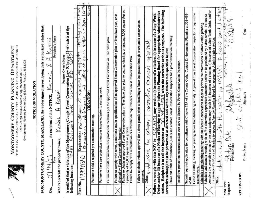
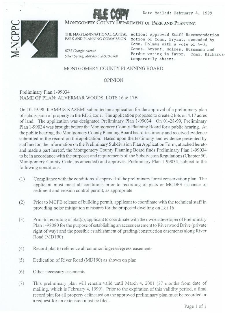
2 STAFF RECOMMENDATION: Approval of the Limited Amendment to the Preliminary Plan and associated Final Forest Conservation Plan, subject to the following conditions: 1. The Applicant must submit a complete record plat application within ninety (90) days of the mailing of the Planning Board Resolution approving the limited amendment to the Preliminary Plan that delineates the revised Category I conservation easement. The existing conservation easement remains in full force and effect until the record plat is recorded in the Montgomery County Land Records by the Applicant. 2. The record plat must reference the standard Category I conservation easement as recorded at liber 13178, folio 412 in the Land Records for Montgomery County, Maryland over the areas identified to remain, as shown on the amended final forest conservation plan. 3. The Applicant must submit a Certificate of Compliance to use an M-NCPPC approved offsite forest mitigation bank within the same watershed within ninety (90) days of the mailing of the Planning Board Resolution approving A. The Certificate of Compliance must provide 0.72 acres (31,363.2 square feet) of mitigation credit for the removal of 0.36 acres (15,681.6 square feet) of Category I conservation easement taken offsite. 4. The Applicant must delineate the revised Category I conservation easement boundary on the property with permanent easement markers and appropriate signage as required by A no later than ninety (90) days from the recordation of the record plat and the new conservation easement. 5. All other conditions of Preliminary Plan No and Forest Conservation Plan No that were not modified herein, as contained in the Planning Board s Opinion dated February 4, 1999, remain in full force and effect. BACKGROUND The Montgomery County Planning Board approved Preliminary Plan Alvermar Woods, on January 28, 1999 for 2 lots (Lots 16 and 17) on 4.17-acres of land in the RE-2 Zone, located in the southwest corner of the intersection of River Road and Riverwood Drive. That application was subject to the Forest Conservation Law (Chapter 22A of the County Code) at the time of approval; therefore, conservation easements were placed on both of the approved lots to meet the requirements of the Law. The original approved forest conservation plan ( FCP ) for preliminary plan showed 1.61 acres of existing forest on the 4.17 acre property, with 1.43 acres of forest retained, and 0.18 acres of forest cleared. Development of the two lots did not generate a planting requirement due to the amount of forest retained on the property. The approved FCP showed 0.33 acres on Lot 16 and 1.1 acres on Lot 17 of retained forest in easement. Lot 17 consisting of 90,309 square feet or 2.07 acres is located at Riverwood Drive in Potomac ( Property or Subject Property ). The Subject Property is currently in violation because the Applicant, and current property owner, constructed a shed, driveway, and pathway in the Category I conservation easement removing the entire understory within the 1.1 acre easement area. An M-NCPPC Inspector ( Inspector ) issued a Notice of Violation (NOV) on July 14, 2009 (see Attachment A). This NOV required the Applicant to schedule and meet with the M-NCPPC to discuss the violation prior to August 15, The Applicant met with the Inspector in the field on July 29, 2009 to discuss the violation as required by the July 14, 2009 NOV. After subsequent discussion between the 2
3 Inspector and the Forest Conservation Program Manager, it was decided that a new NOV should be issued laying out remedial actions required and the deadline in which to complete them. A letter from the M-NCPPC Enforcement Staff was issued on August 28, 2009 (see Attachment B) instructing the Applicant of the appropriate remedial action that was necessary to submit a limited amendment to the preliminary plan by December 1, 2009 in order to revise the FCP. At a minimum, the application was to include a plan to show how areas incompatible with the conservation easement would be mitigated and how other areas of the easement would be restored. A short extension was granted to the Applicant to ensure a complete application at time of submission. The application was received on December 11, On August 10, 2010 the Inspector issued a $ Administrative Citation #EPD to Mr. Kazemi, Applicant, for continued mowing within the Category I conservation easement. On August 25, 2010, the Applicant, through his attorney, contested the citation in writing and requested a hearing in front of the Planning Board. On September 1, 2010, a meeting was held with the Applicant s attorney and the M-NCPPC staff to discuss the citation and a hearing date for the Planning Board as requested in the Applicant s August 25 th letter. The Applicant was informed that the Limited Amendment to the Preliminary Plan would be heard prior to the hearing on the citation. On October 21, 2010 Preliminary Plan Amendment A went to the Planning Board and the Amendment was denied. The Applicant continued to work on the issue through legal means to address the situation and ultimately submitted this application for a new Limited Amendment on July 31,
4 Figure 1: Vicinity Map SITE DESCRIPTION The Subject Property is located at Riverwood Drive, 390 feet south of River Road in the Potomac Subregion Master Plan area, contains a single family residence. The Property is relatively level and has no streams, wetlands, floodplains or buffers on site. The Property is located within the Potomac River Direct watershed, which has a Use I-P designation. The Countywide Stream Protection Strategy rates the water quality in this watershed as having fair quality. 4

5 Figure 2: Two Lot Alvermar Woods Subdivision 5
 by removing and rearranging portions of the Category I conservation easement on the Subject Property.")
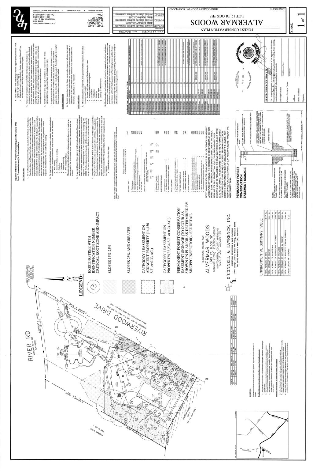
6 Figure 3: Alvermar Woods, Lot 17 (Subject Property) PROPOSAL On July 31, 2011, the Applicant submitted the current application to amend Preliminary Plan and Preliminary Forest Conservation Plan # B ( Application or Amendment ) by removing and rearranging portions of the Category I conservation easement on the Subject Property. This Amendment proposes to rearrange or add 6,898 square feet (0.15 Ac.) of easement area not previously within the easement and remove 15,681.6 square feet (0.36 Ac.) of Category I conservation easement which will be mitigated offsite by purchasing mitigation credit at a 2:1 ratio or 31,363.2 square feet (.72 acres) in the approved Lorax Forest Conservation Bank 1. The recommendations for onsite easement 1 The Lorax Forest, forest conservation bank, is within the same watershed as the Subject Property, Potomac River Direct Watershed. 6

7 replacement and offsite mitigation included in this report, were completed after many months of negotiation and numerous meetings to reach a resolution satisfactory to Staff and the Applicant. Figure 4: Diagram of Easement Changes 7

8 Figure 5: Proposed Category I conservation easements PLANNING BOARD REVIEW AUTHORITY The Forest Conservation Law requires Planning Board action on certain types of modifications to an approved FCP. COMCOR 22A A (2), the Forest Conservation Regulations, state: Major amendments which entail more than a total of 5000 square feet of additional forest clearing must be approved by the Planning Board or the Planning Director (depending on who approved the original plan). 8
9 The Applicant proposes to modify the entire Category I conservation easement on the Subject Property, which is approximately 0.51 acres (22,215 square feet), therefore; the Application must be reviewed by the Planning Board. ANALYSIS AND FINDINGS The Alvermar Woods subdivision property originally had 1.61 acres of forest. The original approved forest conservation plan showed that 0.18 acres of forest was to be removed and that 1.43 acres of forest would be retained. Pursuant to COMCOR 22a-12(h)(2), a Category I conservation easement was placed on the forest as a long-term protection measure to protect the existing forest and ensure that it remains a naturally regenerating forest. The record plat for Lot 17, shows 49,262 square feet (1.13- acres) of Category I conservation easement and references the standard Category I conservation easement language recorded in the land records at Liber folio 412. The record plat Owner Certificate is signed by Kambiz and Azar Kazemi dated April 29, The approved FCP shows that the Category I conservation easements on the plat contained existing forest when the plat was recorded. At this time, no areas left onsite met the definition of forest as defined in Section 22A-3 of the Montgomery County Code, which states, Forest means a biological community dominated by trees and other woody plants (including plant communities, the understory, and forest floor) covering a land area which is 10,000 square feet or greater and at least 50 feet wide*. However, minor portions of a forest stand which otherwise meet this definition may be less than 50 feet wide if they exhibit the same character and composition as the overall stand. Forest includes: (1) areas that have at least 100 live trees per acre with at least 50 percent of those trees having a 2 inch or greater diameter at 4.5 feet above the ground; and (2) forest areas that have been cut but not cleared. (*Note: The definition of forest was changed in 2001, the minimum width was increased from 35 feet to 50 feet.) At a meeting with the Applicant on February 26, 2010, Staff proposed options to address the violation that Staff would support. Those options were: 1) restore the Category I easements to a state which meets the definition of forest and has no activities or objects within it that conflict with the recorded Category I conservation easement; or 2) revise the preliminary plan to remove the Category I conservation easement and provide offsite mitigation acceptable to Staff and the Planning Board. Originally the Applicant chose an alternate solution to address the violation and was denied at the Planning Board on October 21, 2010 (Attachment C). This Amendment is consistent with Staff s original position from February 26, 2010 and is also consistent with current Planning Board practices regarding conservation easement removals. 9
10 The Application, in this case, is in response to a violation and a retroactive process to resolve the violation bringing the Subject Property into compliance. The proposed mitigation for the easement encroachment and subsequent easement removal is to mitigate onsite and offsite in a forest mitigation bank within the same watershed. The Planning Board practice for the removal of conservation easement, as determined in November of 2008, is a minimum ratio of 2:1 if taken offsite. However, if the easement can be rearranged onsite, the Board has found a ratio of 1:1 to be acceptable. Onsite mitigation is generally preferable to offsite mitigation because it provides in-kind and in-place benefits for what is being removed. The Applicant proposed a combination method to meet the Planning Board s mitigation practice. The proposal requests the removal of 0.51 acres (22,215 square feet), of which 6,898 square feet (0.15 Ac.) will be met onsite at a ratio of 1:1 and 0.36 acres (15,681.6 square feet) of easement that cannot be effectively met onsite and will be taken offsite. The 6,898 square feet (0.15 Ac.) of new Category I conservation easement to be placed onsite is within previously unencumbered areas of the Subject Property. Currently the Category I conservation easement areas, both existing and proposed, do not meet the definition of forest due to the absence of understory as a result of the violation. However, the same areas of forest have a well-developed Tulip Poplar-White Oak association canopy layer. Staff believes that this area is a good candidate for natural regeneration of herbaceous and understory species that would be consistent with a Tulip Poplar-White Oak association. Additional understory plantings in this area could be difficult to maintain based upon limited sun from the mature canopy and a persistent whitetail deer population. Natural regeneration would be a good way to re-establish the missing forest community layers and produce native vegetation that is tolerant of both the deer browse and low light conditions. All areas of Category I conservation easement to remain on the Subject Property will be signed with permanent forest conservation signage and separated from the active areas by hardscape. Currently, much of the onsite Category I conservation easement is separated from the yard area by a five foot wide hardscape path built by the Applicant. Staff believes that with the hard line delineation of the pathway and the permanent forest conservation signage the easement area will be readily apparent and there will be no confusion as to the easement boundaries. The 0.36 acres (15,681.6 square feet) of Category I conservation easement removal being mitigated offsite is the minimum amount required to bring the Subject Property into compliance. It will be mitigated by purchasing credits at a 2:1 ratio or 31,363 square feet (.72 acres) in the approved Lorax Forest Conservation Bank located within the Potomac River Direct watershed. The Analysis above played a role in the meetings and discussions that were held while trying to resolve the outstanding violation issue. The Applicants proposal meets the Planning Board s practice for mitigation and will meet all of its offsite mitigation requirements within the same watershed. 10
11 Staff supports the creation of the new onsite easements, the easement removal, and the proposed mitigation as a means to resolve the outstanding encroachment issues bringing the Subject Property into compliance. NOTIFICATION and OUTREACH The Subject Property was signed with notification of the upcoming Preliminary Plan Limited Amendment prior to the July 31, 2012 submission. All adjoining and confronting property owners, civic associations, and other registered interested parties will be notified of the public hearing on the Application. As of the date of this report, Staff has not received any calls or correspondence in regards to this Application. Any comments received hereafter will be forwarded to the Board. CONCLUSION Staff recommends that the Planning Board approve this limited preliminary plan amendment to revise the forest conservation plan with the conditions specified above. Attachments: A. Notice of Violation (NOV) B. Letter and Corrective Action Order C. Opinion for Preliminary Plan Amendment No A (Denied) D. Original Preliminary Plan No E. Original Opinion for Preliminary Plan No F. Original Plat Preliminary Plan No G. Proposed Plan Preliminary Plan Amendment No B 11
12 12 ATTACHMENT A
13 13 ATTACHMENT B
14 14 ATTACHMENT C
15 15 ATTACHMENT C
16 16 ATTACHMENT C
17 17 ATTACHMENT C
18 18 ATTACHMENT C
19 19 ATTACHMENT C
20 20
21
22
23 23
MONTGOMERY COUNTY PLANNING DEPARTMENT THE MARYLAND-NATIONAL CAPITAL PARK AND PLANNING COMMISSION
 MONTGOMERY COUNTY PLANNING DEPARTMENT THE MARYLAND-NATIONAL CAPITAL PARK AND PLANNING COMMISSION St. Andrews Episcopal School, Forest Conservation Plan Amendment, CBA 1389C (In response to violation) MCPB
MONTGOMERY COUNTY PLANNING DEPARTMENT THE MARYLAND-NATIONAL CAPITAL PARK AND PLANNING COMMISSION
 MONTGOMERY COUNTY PLANNING DEPARTMENT THE MARYLAND-NATIONAL CAPITAL PARK AND PLANNING COMMISSION MCPB Item No. Hearing Date: 10/8/15 Howard Hughes Medical Institute, Limited Amendment of the Preliminary
MONTGOMERY COUNTY PLANNING DEPARTMENT THE MARYLAND-NATIONAL CAPITAL PARK AND PLANNING COMMISSION
 MONTGOMERY COUNTY PLANNING DEPARTMENT THE MARYLAND-NATIONAL CAPITAL PARK AND PLANNING COMMISSION MCPB Consent Item Date: 12/19/13 * Consent Item Barton Property: Preliminary Plan Amendment No. 12011021A
MONTGOMERY COUNTY PLANNING DEPARTMENT THE MARYLAND-NATIONAL CAPITAL PARK AND PLANNING COMMISSION
 MONTGOMERY COUNTY PLANNING DEPARTMENT THE MARYLAND-NATIONAL CAPITAL PARK AND PLANNING COMMISSION MCPB Item No. 3 Date: 01-31-13 Preliminary Plan 120090300, Boyds Highlands Calvin Nelson, Jr. Planner Coordinator,
MONTGOMERY COUNTY PLANNING DEPARTMENT THE MARYLAND-NATIONAL CAPITAL PARK AND PLANNING COMMISSION
 MONTGOMERY COUNTY PLANNING DEPARTMENT THE MARYLAND-NATIONAL CAPITAL PARK AND PLANNING COMMISSION Colesville Senior Living Facility, Limited Preliminary Plan Amendment, 12016011A MCPB Consent Item Date:
MONTGOMERY COUNTY PLANNING DEPARTMENT THE MARYLAND-NATIONAL CAPITAL PARK AND PLANNING COMMISSION
 MONTGOMERY COUNTY PLANNING DEPARTMENT THE MARYLAND-NATIONAL CAPITAL PARK AND PLANNING COMMISSION MCPB Item No.: Date: 06-21-12 The Plantations, Preliminary Plan -120090240 Benjamin Berbert, Senior Planner,
MONTGOMERY COUNTY PLANNING DEPARTMENT THE MARYLAND-NATIONAL CAPITAL PARK AND PLANNING COMMISSION
 MONTGOMERY COUNTY PLANNING DEPARTMENT THE MARYLAND-NATIONAL CAPITAL PARK AND PLANNING COMMISSION MCPB Item No. Date: 1-17-13 Preliminary Plan 120110180 - Parmjit & Saini Estates Katherine Holt, Senior
MONTGOMERY COUNTY PLANNING DEPARTMENT THE MARYLAND-NATIONAL CAPITAL PARK AND PLANNING COMMISSION
 MONTGOMERY COUNTY PLANNING DEPARTMENT THE MARYLAND-NATIONAL CAPITAL PARK AND PLANNING COMMISSION MCPB Item No. 8 Date: 03-07-13 Sonoma, Preliminary Plan, 120130040 Melissa Williams, Senior Planner, Melissa.williams@montgomeryplanning.org,
MONTGOMERY COUNTY PLANNING DEPARTMENT THE MARYLAND-NATIONAL CAPITAL PARK AND PLANNING COMMISSION
 MONTGOMERY COUNTY PLANNING DEPARTMENT THE MARYLAND-NATIONAL CAPITAL PARK AND PLANNING COMMISSION MCPB Item No. Date: 12/6/12 Limited Site Plan Amendment, 82000018D, DANAC Stiles Property, Lot 6 of Block
MONTGOMERY COUNTY PLANNING DEPARTMENT THE MARYLAND-NATIONAL CAPITAL PARK AND PLANNING COMMISSION
 MONTGOMERY COUNTY PLANNING DEPARTMENT THE MARYLAND-NATIONAL CAPITAL PARK AND PLANNING COMMISSION MCPB Item No.: Date: 07-28-16 Lake Normandy Estates: Pre-Preliminary Plan No. 720160020 Ryan Sigworth AICP,
MONTGOMERY COUNTY PLANNING DEPARTMENT THE MARYLAND-NATIONAL CAPITAL PARK AND PLANNING COMMISSION
 MONTGOMERY COUNTY PLANNING DEPARTMENT THE MARYLAND-NATIONAL CAPITAL PARK AND PLANNING COMMISSION MCPB Item Date: 06/01/17 900 Thayer Avenue: Project Plan Amendment No. 92005003B and Site Plan Amendment
MONTGOMERY COUNTY PLANNING BOARD
 MONTGOMERY COUNTYPLANNING BOARD T H E MARYLAND-NATIONAL CAPITAL PARK A N D P L A N N I N G C O M M I S S I O N MCPB NO. 10-100 Preliminary Plan No. 120100210 Date of Hearing: July 1, 2010 MONTGOMERY COUNTY
MONTGOMERY COUNTY PLANNING DEPARTMENT THE MARYLAND-NATIONAL CAPITAL PARK AND PLANNING COMMISSION
 MONTGOMERY COUNTY PLANNING DEPARTMENT THE MARYLAND-NATIONAL CAPITAL PARK AND PLANNING COMMISSION MCPB Item No. Date: 10-11-12 Subdivision Review Waiver SRW 2011001: Big Woods Road Richard Weaver, Acting
MONTGOMERY COUNTY PLANNING DEPARTMENT THE MARYLAND-NATIONAL CAPITAL PARK AND PLANNING COMMISSION
 MONTGOMERY COUNTY PLANNING DEPARTMENT THE MARYLAND-NATIONAL CAPITAL PARK AND PLANNING COMMISSION MCPB Item No. Date: 12/4/14 Preliminary Plan No. 120140200, Northwood Knolls Description Patrick Butler,
MONTGOMERY COUNTY PLANNING DEPARTMENT THE MARYLAND-NATIONAL CAPITAL PARK AND PLANNING COMMISSION
 MONTGOMERY COUNTY PLANNING DEPARTMENT THE MARYLAND-NATIONAL CAPITAL PARK AND PLANNING COMMISSION MCPB Item No. Date: 05-22-14 Washington Gas Pipeline No.27 Main Relocation: Mandatory Referral No. MR 2014041
Applicant s Agent Lisa Murphy, Esq. Staff Planner PJ Scully. Lot Recordation 12/01/1972 Map Book 94, Page 33 GPIN
 Property Owner and Applicant Address 3925 Shore Drive Public Hearing September 24, 2018 City Council District Bayside Agenda Item 6 Variance Request Encroachment into the Resource Protection Area (RPA)
MONTGOMERY COUNTY PLANNING DEPARTMENT
 MONTGOMERY COUNTY PLANNING DEPARTMENT THE MARYLAND-NATIONAL CAPITAL PARK AND PLANNING COMMISSION Forest Conservation Law Amendments - Modifications MCPB Item No. 7 Date: 5/24/2018 SUMMARY Mark Pfefferle,
MONTGOMERY COUNTY PLANNING DEPARTMENT THE MARYLAND-NATIONAL CAPITAL PARK AND PLANNING COMMISSION
 MONTGOMERY COUNTY PLANNING DEPARTMENT THE MARYLAND-NATIONAL CAPITAL PARK AND PLANNING COMMISSION MCPB Item No. Date: 9/22/11 Site Plan Amendment 82008011A, North Bethesda Center Parcels F, I, & J Joshua
MONTGOMERY COUNTY PLANNING DEPARTMENT THE MARYLAND-NATIONAL CAPITAL PARK AND PLANNING COMMISSION
 MONTGOMERY COUNTY PLANNING DEPARTMENT THE MARYLAND-NATIONAL CAPITAL PARK AND PLANNING COMMISSION MCPB Consent Item Date: 11-2-17 Washington Adventist Hospital, Site Plan Amendment No. 82008021F Rhoda Hersson-Ringskog,
TENTATIVE MAP INFORMATION SHEET
 TENTATIVE MAP INFORMATION SHEET GENERAL INFORMATION This information sheet explains how your Tentative Map application will be processed, what fees you must pay, and what plans you must submit. If you
MONTGOMERY COUNTY PLANNING BOARD
 MONTGOMERY COUNTY PLANNING BOARD T H E MARYLAND-NATIONAL CAPITAL PARK A N D P L A N N I N G C O M M I S S I O N MCPB NO. 10-144 Hearing Date: September 30, 2010 MONTGOMERY COUNTY PLANNING BOARD RESOLUTION
GROSVENOR-STRATHMORE METRO STATION MANDATORY REFERRAL APPLICATION NORTH BETHESDA, MD
 GROSVENOR-STRATHMORE METRO STATION MANDATORY REFERRAL APPLICATION NORTH BETHESDA, MD Submission by: Fivesquares JDA at Grosvenor Metro, LLC On behalf of Washington Metropolitan Area Transit Authority 1
MONTGOMERY COUNTY PLANNING DEPARTMENT THE MARYLAND-NATIONAL CAPITAL PARK AND PLANNING COMMISSION
 MONTGOMERY COUNTY PLANNING DEPARTMENT THE MARYLAND-NATIONAL CAPITAL PARK AND PLANNING COMMISSION MCPB Item No. 3 Date: 05/28/15 Ingleside, Preliminary Plan No. 120140140 Ryan Sigworth AICP, Senior Planner
RECOMMENDATION: Approval subject to the following conditions:
 RECOMMENDATION: Approval subject to the following conditions: 1) Approval under this preliminary plan is limited to 2 lots for 2 dwelling units 2) The record plat must note that the preliminary plan is
7-l MoNtcoupnv CouNtv PreNNrNc Boeno,I 'tne ITaRYLAND-NATIoNAL CAPITAL PARI< AND PLANNING con{n{ission
 7-l MoNtcoupnv CouNtv PreNNrNc Boeno,I 'tne ITaRYLAND-NATIoNAL CAPITAL PARI< AND PLANNING con{n{ission MCPB No. 16-023 Preliminary Plan No. '120160110 Date of Hearing: March 3, 2016 ltar 17 frft, RESOLUTlON
9 November 12, 2014 Public Hearing
 9 November 12, 2014 Public Hearing APPLICANT AND PROPERTY OWNER: GARRETT A. & BERNADETTE P. ALCARAZ STAFF PLANNER: Kristine Gay REQUEST: Subdivision Variance to Section 4.4(b) of the Subdivision Ordinance,
PLANNING COMMISSION STAFF REPORT. Merrimac PLNSUB Planned Development 38 West Merrimac November 9, Request. Staff Recommendation
 PLANNING COMMISSION STAFF REPORT Merrimac PLNSUB2011-00374 Planned Development 38 West Merrimac November 9, 2011 Planning and Zoning Division Department of Community and Economic Development Applicant:
CHAPTER 6 CHESAPEAKE BAY PRESERVATION AREAS AND STREAM PROTECTION AREAS
 CHAPTER 6 CHESAPEAKE BAY PRESERVATION AREAS AND STREAM PROTECTION AREAS 6.1 INTRODUCTION Virginia s Chesapeake Bay Preservation Area (CBPA) Designation and Management Regulations (9VAC10-20 et seq.) require
MONTGOMERY COUNTY PLANNING BOARD THE MARYLAND-NATIONAL CAPITAL PARK AND PLANNING COMMISSION
 MONTGOMERY COUNTY PLANNING BOARD THE MARYLAND-NATIONAL CAPITAL PARK AND PLANNING COMMISSION APPROVED MINUTES The Montgomery County Planning Board met in regular session on Thursday, February 19, 2015,
Clearcreek Township Zoning Staff Report Soraya Farms Section 6 Stage 3 Review Page 1 of 8
 Staff Report: Completed by Jeff Palmer Director of Planning & Zoning Report Date: September 10, 2018 Meeting Date: October 1, 2018 Applicant: Shery Oakes, agent for Soraya Farms Requested Action: Soraya
Montgomery Village - South Valley Park: Subdivision Regulation Waiver SRW , and Site Plan No
 Montgomery Village - South Valley Park: Subdivision Regulation Waiver SRW - 201402, and Site Plan No. 820140070 12 SUBDIVISION REGULATION WAIVER RECOMMENDATION AND CONDITIONS OF APPROVAL Staff recommends
MONTGOMERY COUNTY PLANNING DEPARTMENT THE MARYLAND-NATIONAL CAPITAL PARK AND PLANNING COMMISSION
 MONTGOMERY COUNTY PLANNING DEPARTMENT THE MARYLAND-NATIONAL CAPITAL PARK AND PLANNING COMMISSION MCPB Item No. 6 Date: 9-27-18 Seneca Farms, Preliminary Plan No. 120170240 Jonathan Casey, Senior Planner,
MONTGOMERY COUNTY PLANNING BOARD
 APR :7 20m MONTGOMERY COUNTY PLANNING BOARD THE MARYLAND-NATIONAL CAPITAL PARK AND PLANNING COMMISSION MCPB No. 10-172 Date of Hearing: December 9, 2010 MONTGOMERY COUNTY PLANNING BOARD RESOLUTION WHEREAS,
VARIANCE APPLICATION
 TOWN OF CARY Submit to the Development Customer Service Center, P.O. Box 8005, Cary, NC 27512 Planning Department Planning Department Contact: (919) 469-4046 Fee: $600.00 For office use only: Method of
THE SUBDIVISION AND LAND DEVELOPMENT REVIEW PROCESS
 THE SUBDIVISION AND LAND DEVELOPMENT REVIEW PROCESS INTRODUCTION: Howard County Subdivision and Land Development Regulations are intended to promote the health, safety and general welfare of County residents.
Plan nt Plan Filing and
 PARISH OF ASCENSION OFFICE OF PLANNING AND DEVELOPMENT PLANNING DEPARTMENT APPENDIX VI PLANNED UNIT DEVELOPMENT (PUD) CODE Contents: 17-601. General Purpose: Procedures... 3 17-602. General Character:...
ZONING & LAND USE APPLICATION
 City of Maple Plain 5050 Independence St P.O. Box 97 Maple Plain, MN 55359 Office: (763) 479-0515 Fax: (763) 479-0519 ZONING & LAND USE APPLICATION APPLICANT INFORMATION Applicant Name Company, if applicable
DANAC Stiles Property. Preliminary Plan A
 DANAC Stiles Property Preliminary Plan 11996112A Vicinity Located in the LSC North District of the GSSC Master Plan. Adjacent Uses North: Single-family attached townhouses, R-60 zone; East: Office building,
ARTICLE III GENERAL PROCEDURES, MINOR PLANS AND FEE SCHEDULES
 ARTICLE III GENERAL PROCEDURES, MINOR PLANS AND FEE SCHEDULES 301. Prior to Submission a. Copies of this Ordinance shall be available on request, at cost, for the use of any person who desires information
PRELIMINARY AND FINAL PLAT APPLICATION AND REVIEW PROCESS
 COMMUNITY DEVELOPMENT PRELIMINARY AND FINAL PLAT APPLICATION AND REVIEW PROCESS Example Timeline MONTH A Preliminary Plat application Su M Tu W Th F Sa MONTH B Preliminary Plat action Su M Tu W Th F Sa
Mariposa County Public Works Department (209) (for road encroachments, road improvements, and engineering issues)
 (for road encroachments, road improvements, and engineering issues)") CONDITIONAL USE PERMIT GENERAL INFORMATION AND APPLICATION Mariposa County Planning Department 5100 Bullion Street, P.O. Box 2039 Mariposa, CA 95338 Telephone (209) 966-5151 FAX (209) 742-5024 www.mariposacounty.org
CONDITIONAL USE PERMIT GENERAL INFORMATION AND APPLICATION Mariposa County Planning Department 5100 Bullion Street, P.O. Box 2039 Mariposa, CA 95338 Telephone (209) 966-5151 FAX (209) 742-5024 www.mariposacounty.org
Staff Report: Date: Applicant: Property Identification: Acreage of Request: Current Zoning of Requested Area: Requested Action: Attached:
 Staff Report: Completed by Jeff Palmer Director of Planning & Zoning Date: November 7, 2018, Updated November 20, 2018 Applicant: Greg Smith, Oberer Land Developer agent for Ronald Montgomery ET AL Property
MONTGOMERY COUNTY PLANNING DEPARTMENT THE MARYLAND-NATIONAL CAPITAL PARK AND PLANNING COMMISSION
 MONTGOMERY COUNTY PLANNING DEPARTMENT THE MARYLAND-NATIONAL CAPITAL PARK AND PLANNING COMMISSION Ganassa Property, Preliminary Plan, 120040640 MCPB Item No. Date: 7-25-13 Callum Murray, Area 3 Supervisor,
Prepared by: Nick Lagura, Associate Planner
 CITY OF CITRUS HEIGHTS PLANNING DIVISION STAFF REPORT PLANNING COMMISSION MEETING May 25, 2016 Prepared by: Nick Lagura, Associate Planner REQUEST The applicant requests approval of a Tentative Parcel
WHEREAS, the staff of The Maryland-National Capital Park and Planning Commission recommended APPROVAL of the application with conditions; and
 R E S O L U T I O N WHEREAS, Redeemed Christian Church of God is the owner of a 2.83-acre parcel of land known as Lot 9, Lot 19, P/O Lot 1 and P/O Lot 18, Block B, Plat Book A, Plat 5, said property being
APPLICATION PACKET SINGLE FAMILY CLUSTER HOUSING OPTION REVIEW
 APPLICATION PACKET SINGLE FAMILY CLUSTER HOUSING OPTION REVIEW COMMUNITY DEVELOPMENT DEPARTMENT CHARTER TOWNSHIP OF PLYMOUTH 9955 N. Haggerty Road Plymouth, MI 48170 Fees Revised 9.13.2017 1. PURPOSE APPLICATION
R E S O L U T I O N. a. Remove Table B from the plan.
 R E S O L U T I O N WHEREAS, Werrlein Property is the owner of a 0.3902-acre parcel of land in the 5th Election District of Prince George s County, Maryland, being zoned One-Family Detached Residential
MONTGOMERY COUNTY PLANNING DEPARTMENT THE MARYLAND-NATIONAL CAPITAL PARK AND PLANNING COMMISSION
 MONTGOMERY COUNTY PLANNING DEPARTMENT THE MARYLAND-NATIONAL CAPITAL PARK AND PLANNING COMMISSION MCPB Item No.: 10 Date: 06-28-18 Park Potomac: Site Plan Amendment No. 82004015N Benjamin Berbert, Planner
MONTGOMERY COUNTY PLANNING DEPARTMENT THE MARYLAND-NATIONAL CAPITAL PARK AND PLANNING COMMISSION
 MONTGOMERY COUNTY PLANNING DEPARTMENT THE MARYLAND-NATIONAL CAPITAL PARK AND PLANNING COMMISSION MCPB Item No. Date: 05-30-13 Pre-Preliminary Plan No. 720130040: Potomac Highlands Callum Murray, supervisor,
STATE OF MICHIGAN COUNTY OF MARQUETTE, TOWNSHIP OF NEGAUNEE LAND DIVISION, SUBDIVISION AND CONDOMINIUM ORDINANCE
 STATE OF MICHIGAN COUNTY OF MARQUETTE, TOWNSHIP OF NEGAUNEE LAND DIVISION, SUBDIVISION AND CONDOMINIUM ORDINANCE Adopted: August 8 th, 2008 Effective: August 28 th, 2008 Sec.100. Title ARTICLE I GENERAL
DRAFT FOR PUBLIC HEARING (rev. March, 2016)
") Chapter 200. ZONING Article VI. Conservation/Cluster Subdivisions 200-45. Intent and Purpose These provisions are intended to: A. Guide the future growth and development of the community consistent with
Chapter 200. ZONING Article VI. Conservation/Cluster Subdivisions 200-45. Intent and Purpose These provisions are intended to: A. Guide the future growth and development of the community consistent with
BY BOARD OF COUNTY COMMISSIONERS AN ACT TO BE ENTITLED
 BY BOARD OF COUNTY COMMISSIONERS ORDINANCE NO. AN ACT TO BE ENTITLED AN ORDINANCE AMENDING THE PASCO COUNTY LAND DEVELOPMENT CODE, ARTICLE 700, BY REPEALING EXISTING SECTION 702, ENVIRONMENTALLY SENSITIVE
APPLICATION PROCEDURES FOR A MAJOR SUBDIVISION PRELIMINARY PLAT
 APPLICATION PROCEDURES FOR A DEFINITION: The subdivision of a tract of land into at least three (3) residential, commercial, or industrial parcels, including the remainder of the original parcel, fronting
APPLICATION FOR MAJOR SUBDIVISION APPROVAL (PRELIMINARY PLAT)
") 209 S. Main Street Marysville, Ohio 43040 Phone: (937) 645-7350 Fax: (937) 645-7351 www.marysvilleohio.org APPLICATION FOR MAJOR SUBDIVISION APPROVAL (PRELIMINARY PLAT) *** IMPORTANT INFORMATION ~ Please
209 S. Main Street Marysville, Ohio 43040 Phone: (937) 645-7350 Fax: (937) 645-7351 www.marysvilleohio.org APPLICATION FOR MAJOR SUBDIVISION APPROVAL (PRELIMINARY PLAT) *** IMPORTANT INFORMATION ~ Please
ORANGE TOWNSHIP SIDEWALK CONSTRUCTION, REPAIR AND MAINTENANCE POLICY
 RES. 09-214 ADOPT SIDEWALK CONSTRUCTION, REPAIR AND MAINTENANCE POLICY Agan moved the adoption of the following Resolution: WHEREAS, the Township has previously, by Res. 06-382, adopted a sidewalk, repair
MONTGOMERY COUNTY PLANNING DEPARTMENT THE MARYLAND-NATIONAL CAPITAL PARK AND PLANNING COMMISSION
 MONTGOMERY COUNTY PLANNING DEPARTMENT THE MARYLAND-NATIONAL CAPITAL PARK AND PLANNING COMMISSION MCPB Item No. 5 Date: 12-15-16 Bradford s Landing, Preliminary Plan, 120170060 Description Sandra Pereira,
WRIGHT TOWNSHIP Ottawa County 1565 Jackson Street, P.O. Box 255, Marne, Michigan 49435
 WRIGHT TOWNSHIP Ottawa County 1565 Jackson Street, P.O. Box 255, Marne, Michigan 49435 SITE PLAN REVIEW APPLICATION _ Instructions For an application to be considered complete, ALL information must be
WRIGHT TOWNSHIP Ottawa County 1565 Jackson Street, P.O. Box 255, Marne, Michigan 49435
 WRIGHT TOWNSHIP Ottawa County 1565 Jackson Street, P.O. Box 255, Marne, Michigan 49435 SPECIAL USE PERMIT APPLICATION _ Instructions For an application to be considered complete, ALL information must be
MONTGOMERY COUNTY PLANNING DEPARTMENT THE MARYLAND-NATIONAL CAPITAL PARK AND PLANNING COMMISSION
 MONTGOMERY COUNTY PLANNING DEPARTMENT THE MARYLAND-NATIONAL CAPITAL PARK AND PLANNING COMMISSION MCPB Item No. 9 Date: 9-22-16 Proposed Category Map Amendments: Montgomery County Comprehensive Water Supply
Bowie Marketplace Residential Detailed Site Plan Statement of Justification January 13, 2017 Revised February 2, 1017
 Bowie Marketplace Residential Detailed Site Plan Statement of Justification January 13, 2017 Revised February 2, 1017 Submitted on behalf of: BE Bowie LLC 5410 Edson Lane, Suite 220 Rockville, MD 20852
SMALL CELL TECHNOLOGY in the Right-of-Way ADMINISTRATIVE VARIANCE APPLICATION Community Development Department
 PURPOSE OF ADMINISTRATIVE VARIANCE SMALL CELL TECHNOLOGY in the Right-of-Way Pursuant to Sec. 23-706(h), an Administrative Variance is required for installation of a new Small Cell Technology Wireless
Planning Commission Report
 cjly City of Beverly Hills Planning Division 455 N. Rexford Drive Beverly Hills, CA 90210 TEL. (310) 285-1141 FAX. (370) 858-5966 Planning Commission Report Meeting Date: April 28, 2016 Subject: Project
Greenfield Development Requirements
 Greenfield Development Requirements Planning & Engineering Department City of Yorkton Saskatchewan 2014 Summary Greenfield Development refers to the development of raw land to a finished state as residential,
MONTGOMERY COUNTY PLANNING DEPARTMENT THE MARYLAND-NATIONAL CAPITAL PARK AND PLANNING COMMISSION
 MONTGOMERY COUNTY PLANNING DEPARTMENT THE MARYLAND-NATIONAL CAPITAL PARK AND PLANNING COMMISSION MCPB Item No.: 4 Date: 2-7-19 Old Angler s Cove, Preliminary Plan No. 120170290 Ryan Sigworth AICP, Senior
APPLICATION PACKET SINGLE FAMILY CLUSTER HOUSING OPTION REVIEW
 APPLICATION PACKET SINGLE FAMILY CLUSTER HOUSING OPTION REVIEW COMMUNITY DEVELOPMENT DEPARTMENT CHARTER TOWNSHIP OF PLYMOUTH 9955 N. Haggerty Road Plymouth, MI 48170 Fees Revised 7/01/2012 1. PURPOSE APPLICATION
COUNTY COUNCIL OF PRINCE GEORGE'S COUNTY, MARYLAND 2012 Legislative Session
 DR- COUNTY COUNCIL OF PRINCE GEORGE'S COUNTY, MARYLAND Legislative Session Bill No. CB-- Chapter No. Proposed and Presented by Introduced by The Chair (by request Planning Board) Council Member Franklin
STATE OF MICHIGAN COUNTY OF BERRIEN ORONOKO CHARTER TOWNSHIP PRIVATE ROAD ORDINANCE ORDINANCE NO. 65
 STATE OF MICHIGAN COUNTY OF BERRIEN ORONOKO CHARTER TOWNSHIP PRIVATE ROAD ORDINANCE ORDINANCE NO. 65 AN ORDINANCE TO REQUIRE THAT ALL LOTS OR PARCELS OF LAND WHICH DO NOT ABUT PUBLIC STREETS ABUT A PRIVATE
1 September 9, 2015 Public Hearing
 1 September 9, 2015 Public Hearing APPLICANT & PROPERTY OWNER: HOLLOMON- BROWN FUNERAL HOME, INC. STAFF PLANNER: Carolyn A.K. Smith REQUEST: Change of Zoning (R-5D Residential District to Conditional O-2
Lake County Planning, Building and Development Department
 SUBMISSION CHECKLIST FOR SUBDIVISION FINAL PLAT Lake County Planning, Building and Development Department 500 W. Winchester Rd. Unit 101 Libertyville, Illinois 60048-1331 Telephone (847) 377-2600 E-mail:
KETCHUM PLANNING AND ZONING
 IN RE: ) Barrow Variance and ) Fence Design Review ) KETCHUM PLANNING AND ZONING ) COMMISSION - FINDINGS OF FACT, ) CONCLUSIONS OF LAW AND DECISION Permit Number: 13-122 ) BACKGROUND FACTS OWNER: Strada
Chesapeake Bay Preservation Area (CBPA) Map Update. Presentation to the County Board July 15, 2017
 Map Update. Presentation to the County Board July 15, 2017") Chesapeake Bay Preservation Area (CBPA) Map Update Presentation to the County Board July 15, 2017 Chesapeake Bay Program Comprehensive Plan Chesapeake Bay Preservation Ordinance (1992) (Chapter 61, Arlington
Chesapeake Bay Preservation Area (CBPA) Map Update Presentation to the County Board July 15, 2017 Chesapeake Bay Program Comprehensive Plan Chesapeake Bay Preservation Ordinance (1992) (Chapter 61, Arlington
LABEL PLEASE NOTE: ALL APPLICATIONS AND SITE PLANS MUST BE COMPLETED IN BLACK OR BLUE INK ONLY Intake by:
 STAFF USE ONLY Thurston County Resource Stewardship 2000 Lakeridge Dr. S.W. Olympia, WA 98502 (360)786-5490 / (360)754-2939 (Fax) TDD Line (360) 754-2933 Email: permit@co.thurston.wa.us Supplemental Application
PALM BEACH COUNTY PLANNING, ZONING AND BUILDING DEPARTMENT ZONING DIVISION
 PALM BEACH COUNTY PLANNING, ZONING AND BUILDING DEPARTMENT ZONING DIVISION Application No.: DOA-2014-01111 Application Name: World Class Academy Control No.: 1998-00052 Applicant: World Class Academy Inc
PLANNED UNIT DEVELOPMENTS (Ordinance No.: 3036, 12/3/07; Repealed & Replaced by Ordinance No.: 4166, 10/15/12)
") 159.62 PLANNED UNIT DEVELOPMENTS (Ordinance No.: 3036, 12/3/07; Repealed & Replaced by Ordinance No.: 4166, 10/15/12) A. PURPOSE 1. General. The Planned Unit Development (PUD) approach provides the flexibility
159.62 PLANNED UNIT DEVELOPMENTS (Ordinance No.: 3036, 12/3/07; Repealed & Replaced by Ordinance No.: 4166, 10/15/12) A. PURPOSE 1. General. The Planned Unit Development (PUD) approach provides the flexibility
The ARCHITECTURAL REVIEW PROCESS
 The ARCHITECTURAL REVIEW PROCESS COLUMBIA PLACE CHAPEL HILL, NC Introduction/Purpose Architectural Guidelines Procedure and Application Instructions Architectural Review Application This document sets
TOWN OF WATERVILLE VALLEY NEW HAMPSHIRE SITE PLAN REVIEW REGULATIONS
 TOWN OF WATERVILLE VALLEY NEW HAMPSHIRE Effective date March 17, 1981 Revised March 16, 1982 Revised March 13, 1986 Revised March 10, 1987 Revised March 14, 2013 Revised March 8, 2016 TOWN OF WATERVILLE
MONTGOMERY COUNTY PLANNING DEPARTMENT
 MONTGOMERY COUNTY PLANNING DEPARTMENT THE MARYLAND-NATIONAL CAPITAL PARK AND PLANNING COMMISSION MCPB Item No. 9 Date: 9/7/17 (SRA 17-01) Approval Procedures Burial sites; Bill 24-17 Land Use Information
BOROUGH OF JESSUP SUBDIVISION AND LAND DEVELOPMENT ORDINANCE
 BOROUGH OF JESSUP SUBDIVISION AND LAND DEVELOPMENT ORDINANCE 1993 Amended May 1995 Reenacted May 2000 Amended February 9, 2004 Amended May 7, 2007 SUBDIVISION AND LAND DEVELOPMENT ORDINANCE BOROUGH OF
HERON LANDING SUBDIVISION
 HERON LANDING SUBDIVISION Engineering Comments: Per FEMA guidelines, any development greater than 5 acres in size or subdivision 50 lots in size, requires a flood study. Width of drainage easement to be
CARROLL COUNTY BUREAU OF DEVELOPMENT REVIEW OFF-CONVEYANCE SUBMITTAL CHECKLIST AND REVIEW FEE SHEET NOTICE: INCOMPLETE SUBMITTALS WILL BE RETURNED
 CARROLL COUNTY BUREAU OF DEVELOPMENT REVIEW OFF-CONVEYANCE SUBMITTAL CHECKLIST AND REVIEW FEE SHEET An off-conveyance submittal shall include all items as specified in Section 103-7 of the Code of Public
Great Falls Woods Homeowners Association, Inc.
 Great Falls Woods Homeowners Association, Inc. POLICY RESOLUTION NO. 2015-001 Hardwood Tree Removal Procedures WHEREAS, Article VII, Section 7.14 of the Bylaws of the Great Falls Homeowners Association,
County Council Of Howard County, Maryland
 County Council Of Howard County, Maryland 010 Legislative Session Legislative Day No. 7 Resolution No. 91-010 Introduced by: The Chairperson at the request of the County Executive A RESOLUTION pursuant
Staff Report: Date: Applicant: Property Identification: Acreage of Request: Current Zoning of Requested Area: Requested Action: Attached:
 Staff Report: Completed by Jeff Palmer Director of Planning & Zoning Date: November 7, 2018 Applicant: Greg Smith, Oberer Land Developer agent for Ronald Montgomery ET AL Property Identification: Frontage
Minnesota Board of Water and Soil Resources Wetland Conservation Act 2017 Annual Reporting Form
 Minnesota Board of Water and Soil Resources Wetland Conservation Act 2017 Annual Reporting Form Use the tab key to navigate between fields. Local Government Unit (LGU): Becker SWCD Organization Type: SWCD
APPLICATION FOR SUBDIVISION APPROVAL OF A SKETCH PLAN with checklist
 Prior to filing any application for SUBDIVISION approval, the applicant shall request in writing that the zoning administrator schedule a pre-submission conference. APPLICATION TO THE PLANNING BOARD TOWN
City Of Attleboro Conservation Commission
 City Of Attleboro Conservation Commission GOVERNMENT CENTER, 77 PARK STREET ATTLEBORO, MASSACHUSETTS 02703 (508) 223 2222 FAX 222 3046 GENERAL INSTRUCTIONS AND CHECKLIST FOR COMPLETING STORMWATER MANAGEMENT
STANDARDS GOVERNING CONVEYANCES OF REAL PROPERTY IN DARKE COUNTY, OHIO
 STANDARDS GOVERNING CONVEYANCES OF REAL PROPERTY IN DARKE COUNTY, OHIO As directed by Section 319.203 of the Ohio Revised Code which states The County Auditor and the County Engineer shall adopt standards
CHAPTER 50 MONTGOMERY COUNTY SUBDIVISION REGULATIONS
 CHAPTER 50 MONTGOMERY COUNTY SUBDIVISION REGULATIONS Effective February 13, 2017 Sec. 3. Effective Date. This amendment takes effect on February 13, 2017. The amendment applies to any Planning Board action
CHAPTER 50 MONTGOMERY COUNTY SUBDIVISION REGULATIONS PLANNING BOARD DRAFT July 31, 2015
 CHAPTER 50 MONTGOMERY COUNTY SUBDIVISION REGULATIONS PLANNING BOARD DRAFT July 31, 2015 Chapter 50: Subdivision Regulations Page Intentionally Blank Chapter 50: Subdivision Regulations TABLE OF CONTENTS
ELK RAPIDS TOWNSHIP ANTRIM COUNTY, MICHIGAN ORDINANCE NO
 ELK RAPIDS TOWNSHIP ANTRIM COUNTY, MICHIGAN ORDINANCE NO. 3-2011 AN ORDINANCE TO REPLACE THE SUBDIVISION CONTROL ORDINANCE WITH A NEW SUBDIVISION DEVELOPMENT ORDINANCE, IN ACCORD WITH THE LAND DIVISION
MAPLE GROVE PLANNING COMMISSION May 26, 2015
 MAPLE GROVE PLANNING COMMISSION CALL TO ORDER A meeting of the Maple Grove Planning Commission was held at 7:00 p.m. on at the Maple Grove City Hall, Hennepin County, Minnesota. Chair Colson called the
Town of Lincolnville Subdivision Ordinance
 Town of Lincolnville Subdivision Ordinance November 8, 2005 Amended: 06-10-2008---Article 4, Section 4.4.1 Conceptual Plan 06-11-2015---Article 5, Section 5.2.3.i., Article 6.2.3.l., Article 8 & 12 Access
DEED OF EASEMENT AND AGREEMENT Forest Conservation Easement
 DEED OF EASEMENT AND AGREEMENT Forest Conservation Easement THIS DEED OF EASEMENT AND AGREEMENT, made this day of, 20, between ( Property Owner ), and Anne Arundel County, Maryland, a body corporate and
Operating Standards Attachment to Development Application
 Planning & Development Services 2255 W Berry Ave. Littleton, CO 80120 Phone: 303-795-3748 Mon-Fri: 8am-5pm www.littletongov.org Operating Standards Attachment to Development Application 1 PLANNED DEVELOPMENT
ARTICLE 8C SITE CONDOMINIUM DEVELOPMENT ORDINANCE
 ARTICLE 8C SITE CONDOMINIUM DEVELOPMENT ORDINANCE SECTION 8C.01 PURPOSE It is the purpose of this Ordinance to insure that plans for development within Oceola Township proposed under the provisions of
Thurston County Planning Department BOARD OF COUNTY COMMISSIONERS PUBLIC HEARING DRAFT AMENDMENTS TO THE CRITICAL AREAS REGULATIONS. Chapter 24.
 Thurston County Planning Department BOARD OF COUNTY COMMISSIONERS PUBLIC HEARING DRAFT AMENDMENTS TO THE CRITICAL AREAS REGULATIONS Chapter 24.01 GENERAL PROVISIONS Chapter 24.01 6/4/2012 GENERAL PROVISIONS
EL DORADO COUNTY DEVELOPMENT SERVICES ZONING ADMINISTRATOR STAFF REPORT VARIANCE
 EL DORADO COUNTY DEVELOPMENT SERVICES ZONING ADMINISTRATOR STAFF REPORT Agenda of: August 6, 2008 Item No.: Staff: 4.d. Robert Peters VARIANCE FILE NUMBER: V08-0004 APPLICANT: Joseph and Ingrid Herrick
(voice) (fax) (voice) (fax) Site Plan Review
 (fax) (voice) (fax) Site Plan Review") Town of South Boston PO Box 417 455 Ferry Street South Boston Virginia 24592 Planning Department Public Works Department (Engineering) 434.575.4241 (voice) 434.575.4275 (fax) 434.575.4260 (voice) 434.575.4275
Town of South Boston PO Box 417 455 Ferry Street South Boston Virginia 24592 Planning Department Public Works Department (Engineering) 434.575.4241 (voice) 434.575.4275 (fax) 434.575.4260 (voice) 434.575.4275
CZMP Workshop Preserving Your Community & The Environment From Development Impacts
 CZMP Workshop Preserving Your Community & The Environment From Development Impacts Sponsored By Community & Environmental Defense Services 410-654-3021 www.ceds.org/bcmd Help@ceds.org Greater Baltimore
Amendment to the Zoning and Subdivision Ordinances; Consider Repeal Cluster Development Standards
 2 Board of Supervisors Meg Bohmke, Chairman Gary F. Snellings, Vice Chairman Jack R. Cavalier Thomas C. Coen L. Mark Dudenhefer Wendy E. Maurer Cindy C. Shelton February 28, 2018 Thomas C. Foley County