Trumbull County Planning Commission and Staff
|
|
|
- Kristian Pitts
- 5 years ago
- Views:
Transcription

1
2
3 Trumbull County Planning Commission and Staff Planning Commission Members Lewis Kostoff James J. Shader Frank S. Fuda Paul E. Heltzel Daniel E. Polivka Jeff Brown Jerry Henn John Mahan Richard Musick John Sliwinski Lawrence Wright Chairman Vice Chairman County Commissioner County Commissioner County Commissioner Member Member Member Member Member Member Planning Commission Staff William Miller Trish Nuskievicz Greg Bugnone Christine Clementi David Dubiaga Julie Green Lisa Ramsey Mitzi Sabella Mark Zigmont Director Assistant Director Planner III Administrative Assistant Plats and Zoning Coordinator Grants Coordinator Planner II Secretary II Economic Development Coordinator With Assistance From Alan Knapp Jonathan Millea Interns Sarah Kourian John Velk
4 Table of Contents Planning Commission Staff... Table of Contents.. Maps.. Figures... Introduction... i iii v vii 1 Inventory and Analyses History... Population and Demographics.. Township Administration Environmental and Physical Characteristics. Transportation... Housing and Neighborhoods..... Sanitary Sewer and Water Facilities. Community Facilities and Services... Police Department. Fire Department. Road Department... Parks and Recreation. Existing Land Use. Zoning... Public Input Meetings... E-Government Plan of Development Sanitary Sewer and Water Element... Community Facilities Element..... Environmental Element. Green Element... Future Land Use Element..... E-Government Element. Zoning Review and Recommendations. Evaluating and Updating the Comprehensive Plan Table of Contents iii
5 1 Introduction Inventory Table of Contents Environmental and Physical Characteristics History Population Transportation Administration Police Department Fire Department Road Department E-Government Parks and Recreation Sanitary Sewer and Water Facilities Housing and Neighborhood Analysis Existing Land Use Zoning Public Input Meetings Plan of Development Future Land Use Plan Sanitary Sewer and Water Plan Community Facilities Plan Green Plan Zoning Review and Recommendations E-Government Plan Environmental Plan Table of Contents 3
6 Maps State of Ohio Trumbull County Survey Map Historical Re-Creation Survey Map 150 Year Comparison.... Median Household Income.. Census Reference Population Living Below Poverty Level. Female-Headed Households.... Bedrock Geology. Groundwater Yields and Aquifer Geology.. Depth-to-bedrock. Glacial Geology... Topographic Contours. Watersheds... Sub-Watersheds... Slopes.. Soil Characteristics Wetland and Hydric Soils Special Flood Hazard Areas Transportation Corridors. Percent Renter Occupied Home Values. Home Values... Neighborhoods. Sewer Plan... Water Districts..... Existing Land Use... Nonconforming Parcels... Zoning Future Sewer Plan Future Water Plan Future Land Use Maps v
7 Figures 1 Population Growth Trends 27 2 Comparison of Selected Township Population Comparison of Percentage Growth for Selected Townships 28 4 Comparison of Population of Selected Locations Comparison of Percentage Growth of Selected Locations Labor Force Status 30 7 Employed Persons 16 Years or Older by Industry 31 8 Travel Time to Work Age Groups Age Group by Gender Percentage of Population 25 Years or Older with High School Diploma or Higher Median Household Income of Selected Locations Median Household Income by Census Tract Percent of Population Living Below Poverty Level Percent of Population by Race Percent of Population by Race by Block Group Size of Households Percent of Female-Headed Households Poverty Thresholds Poverty Thresholds Local Climatological Data Precipitation Snowfall Average Daily Traffic Volumes Total Crashes Year Structure Built Residential Building Permits Percent Change in Number of Housing Units in Select Locations Number of Houses Built by Year Percent of Vacant Housing Units Percent of Renter Occupied Housing Units Value of Owner Occupied Homes in Selected Locations House Heating Fuel Bedrooms in Housing Units Gross Rent Paid in Cash Mortgage Status Selected Monthly Owner Costs for Mortgaged Owner Occupied Housing Units Consent Decree Areas in Bazetta Township Officer Activity Recap Year End Budget Status Vehicle Inventory Radio and Related Equipment Inventory Weapons and Related Items Inventory Radar and Related Equipment Inventory Investigative Equipment Inventory Figures vii
8 46 Lap Top and Related Equipment Inventory Software Licenses Inventory Miscellaneous Police Equipment Office Equipment Inventory Miscellaneous Equipment Inventory, Police Fire Department Equipment Inventory Road Department Hour Summaries General Equipment Inventory Snow Plow Accessories Inventory Water Pump Equipment Inventory Hand Tool Equipment Inventory Power Tool Inventory Sign Inventory Miscellaneous Equipment Inventory, Fire Office Inventory Cemetery Equipment Inventory Township Park Inventory Public Golf Courses Land Use Codes Bazetta Township Area City of Cortland Area Bazetta Township District Area Residential District Statistics Number of Lots Acreage of Lots Permitted Uses District Uses Development Standards Services Rated by Percentage Strengths Recommended Improvements Recommended Infrastructure Improvements Sanitary Sewer and Water Infrastructure Improvements Petition Process. 243 Figures viii
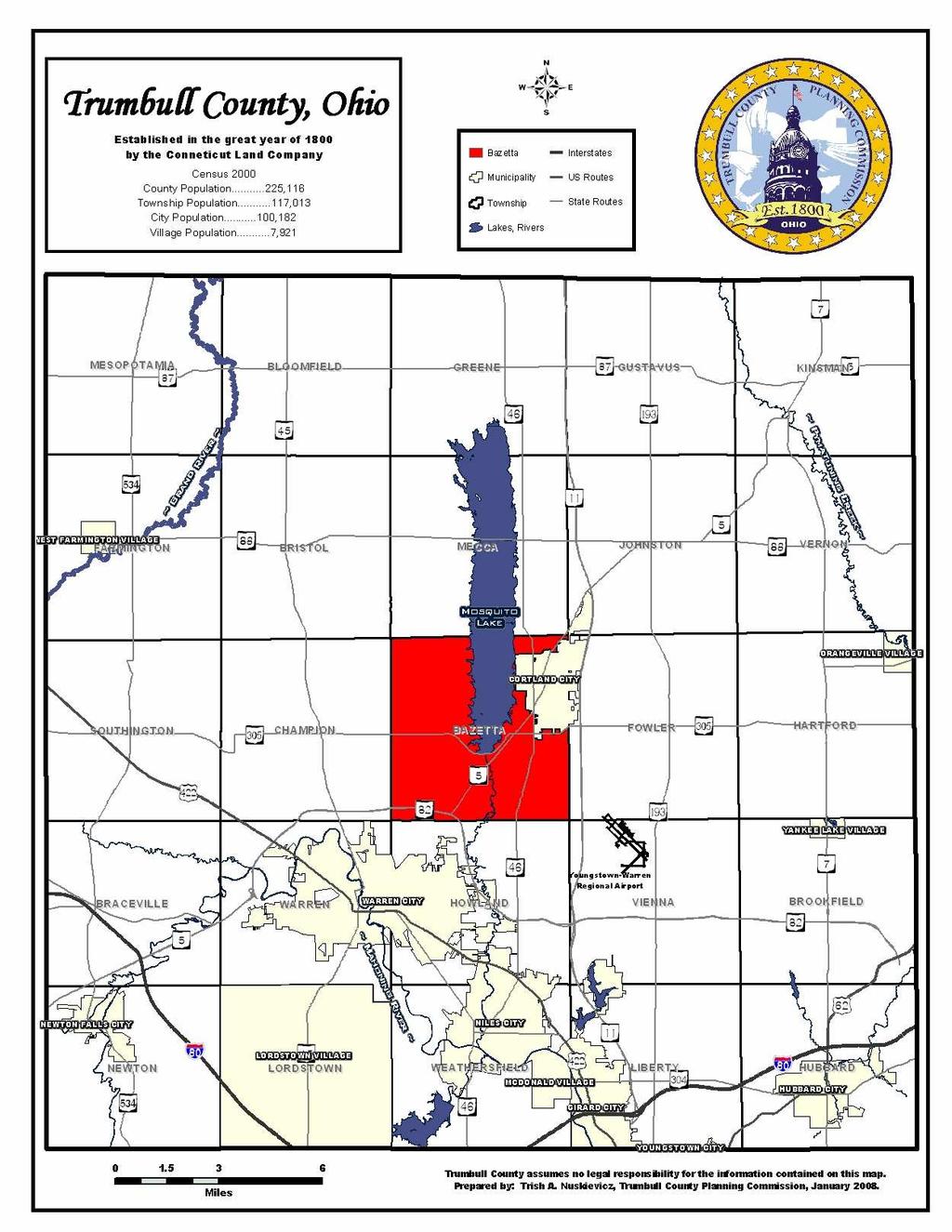
9 Introduction Bazetta Township is a community with a population of 6,306 in Bazetta is located directly in the center of Trumbull County. The township encompasses 17,247 acres; however, Cortland City occupies a significant portion of the northeastern part of the township. The major natural feature of the township is Mosquito Creek Lake, which divides the township in half from north to south for the bulk of the township. The south central portion of the township continues to experience a division from the extending Mosquito Creek. The major roadways of the township are State Route 305, State Route 46, and State Route 5. Regionally, the township is located just north of the urbanized corridor in the Youngstown Warren Metropolitan Area in the State of Ohio. The metropolitan area, also known as the Mahoning Valley, generally consists of Trumbull and Mahoning Counties in Ohio. The Mahoning River flows through the southern part of Trumbull County and then into Mahoning County, and eventually drains into the Beaver River and then the Ohio River. Industrialization came to this area because of the river and sprouted up along its banks. Bazetta Township s location immediately north of this area means the township is experiencing growth from a largely rural township to one in the early stages of urban growth. This is especially evident on State Route 5 and State Route 46, which is experiencing commercial growth in the southernmost portions of the township and residential growth further north before reaching Cortland. A comprehensive plan is a guide for future development in a community, establishing the area s vision for new growth or preservation of the environment. Present trends indicate that the urbanizing population of Bazetta Township can expect great demands in the future. Planning is necessary in helping decision makers anticipate the future and provide for its needs. The Trumbull County Planning Commission has prepared such a plan for Bazetta Township at the request of the Bazetta Township Trustees. The Bazetta Township Comprehensive Plan will have three major components: an inventory and an analysis of the information collected, a plan, and an implementation schedule. The inventory phase of the study will provide a snapshot of current conditions in the township today, including the land use, zoning, environmental conditions, water and sanitary sewer facilities, community facilities, transportation, and other facilities. This information will then be analyzed to identify strengths, weaknesses, opportunities, and constraints to new development in different areas of the township. In the plan phase, community leaders will be asked to prioritize recommendations for the future for new development, zoning, water and sanitary sewer facilities, and related issues. A Future Land Use Map and Plan will be prepared to visualize the community s desires for the future. Finally, an implementation schedule will be devised to help guide the future actions of the township and county in implementing high priorities established in the plan. Introduction 1

10 Introduction 2
11 Introduction 3
12
13 Inventory and Analyses
14

15 History The Connecticut Western Reserve The Sumner-Savory Map of the Western Reserve including the Fire Lands in Ohio (1826) The historical foundation for settling present day Trumbull County began with the Connecticut Western Reserve. The lands northwest of the Ohio River were heavily disputed among several claims of ownership. Much of the dispute was owed to a lack of accurate information regarding the extent of this territory. As a result of inaccurate information, Virginia had claimed nearly all of the land, while Connecticut, Massachusetts, New York, and Pennsylvania had claimed portions of land as well. Charters issued by the Kings of Great Britain conflicted and granted ownership of the same territory to more than one colony. The territory soon called the Connecticut Western Reserve faced a major dispute of ownership as in 1660 Charles II granted title to Connecticut and in 1662, granted title of the same land to New York. Much of the conflict over territory ended by 1733, save a fierce dispute over land just east of the Western Reserve in present day Pennsylvania. This land, called Westmoreland County, was the source of a very bitter and often violent dispute between Pennsylvania and Connecticut. In 1786, Connecticut surrendered the title of Westmoreland County to Pennsylvania in exchange for the undisputed ownership of the Western Reserve territory. This left Connecticut with a rather large tract of land and the decision of exactly how to settle it. The territory extended from the Pennsylvanian border in the east, to 120 miles westward, and from the shoreline of the lake in the north, to the 41 st parallel in the south. Connecticut created a committee of three members whose job was to decide how to disperse the lands of the Western Reserve. The final decision divided the land into tiers and ranges with number 1 being the History 7
16 township of Poland. Each township was five miles square. Land was sold at the price of 50 cents an acre. The majority of the land was sold to a group of investors who formed the Connecticut Land Company. The only land not sold to these investors was the Salt Springs Tract, which was sold to Judge Samuel Parsons in 1788 and the Firelands Tract, which was given to those that lost homes and land in Connecticut during the Revolutionary War. From 1786 until 1800, the Connecticut Western Reserve existed without being under formal jurisdiction of the United States. Though by 1800, the growing settlement in the area drew the attention of Congress. In May of 1800, Connecticut agreed to give jurisdiction to the federal government. On July 10, 1800, Trumbull County was officially formed with the county seat located in Warren. The territory covered in the new county included all the land in the Western Reserve. The county was named Trumbull after Jonathan Trumbull, Governor of Connecticut at the time. During the first half of the 1800s, Trumbull County was divided into Geauga County, Ashtabula County, Portage County, Mahoning County, and present day Trumbull County. Bazetta Township The 17,247 acres of present day Bazetta Township were purchased from the Connecticut Land Company by David Huntington, Nathaniel Shalor, Samuel P. Lord, Sylvester Mather, and Richard McCurdy. The proprietors subsequently divided the land into 100 unequally sized lots in These owners then set forth with the task of selling the land to potential settlers. The first settlers were Edward Scofield, Henry Hulse, John Budd, and their families. Arriving in 1804, Scofield built the first structure, a long cabin, located on present day Route 5 at the corner of Hillman and High streets. Thus began the pattern of settlement in the northeast corner of the township. A northeastern centered settlement was fairly unique to Bazetta Township. For the most part, Western Reserve Settlers settled in the center of the township first. Further perpetuating the pattern begun by Scofield was the fact the much of the land in the south and west of the township was owned by the heirs of Connecticut residents, and because they were not yet of age, the land remained unsettled. The swampy center of the township and the crossing of the Shenango Division of the Erie railroad contributed to this settlement pattern as well. This pattern of development has continued, as the northeast corner of the township is now Cortland City, while population distribution remains less concentrated in the remainder of the township. Klondike Corners was perhaps the only historically notable deviation from this pattern. The crossroads at Hoagland Blackstub (Bazetta Road) and Everett Cortland Hull Road, was the center of a small cluster of population that was briefly referred to as Klondike Corners. Although presently Klondike Corners no longer is a significant location of population in the township, the name still occasionally appears on maps. The origin of the name Klondike is unknown, but it has been suggested that the name is in reference to the gold rush of the late 1800s. Klondike even briefly hosted a post office and occasionally received mail addressed to Klondike, although the area was never officially named anything other than Bazetta. The origin of the name Bazetta is also unknown, although some speculation of its source does exist. Most speculation leads back to the daughter of Edward Scofield, Mrs. R. Scofield Abell, History 8
17 who in an interview with the Western Reserve Chronicle mentioned that her father named the township. Abell suggests that her father selected a name from the Bible. Since the Bible lacks any mention of a Bazetta, a few theories have been proposed. One, from Thomas Kachur, author of Historical Collections of Bazetta Township, suggests that the name might come from a location mentioned in the Bible. In Jerusalem, a pool of waters called Beth-zatha is located near Mount Bezetha. Both names could possibly have been the origin of Bazetta. Another theory uncovered by Bob Smith, was that Bazetta was the tune to a popular hymn in the 1800s. A third theory was mentioned in a script written by the Delta Kappa Gamma Society for the Trumbull County Historical Program. The name origin was suggested as being an Indian name. One thing is certain though, the name Bazetta stands unique and cannot be found as a place name anywhere else in the world. Early Settlement A few years after Edward Scofield settled in the township, he built a gristmill on Walnut Run. The mill was a compliment to the agrarian society in Bazetta Township. Farming of a variety of crops including corn, wheat, flax, and oats, was the primary industry. Additional industry in the area included raising dairy cattle, trade of butter and cheese, and harvesting maple sugar and syrup. Stone quarries in the township provided material for cellars and the foundations of barns and houses. Although local industry kept the growth of the township steady in later years, the first decade of settlement in the township would hardly qualify as a population explosion. In 1804, two families moved in the area. Six years later in 1810, that number had only increased to seven families. However, with the building of the gristmill and the later addition of the sawmill in 1816, the growth rate began to increase so that by 1856 the population was 1,302. Schools Formal schooling was established by 1810 although school was not held in a proper schoolhouse. In 1813, a sturdy structure was built specifically for the purpose of a schoolhouse. Several schools were organized in the years that followed to help accommodate the dispersed population and the physical environment. Mosquito Creek divided the township and in the spring, the swollen creek often cut the west side off from the east side. Until 1929, the township operated under district or one-room schoolhouses. Typically, the township had three or four one-room schoolhouses in operation and functioning separately from the district school in Cortland. Bazetta Township maintained the one room school district system until These schools were the last of their kind in Trumbull County. The last three one-room school districts were the Klondike School (actually two buildings), located on Everett Hull Road; Bazetta School number 3, centrally located in the township just west of Mosquito Creek; and Bazetta School number 4, located in the southwest part of the township. In 1929, the township centralized the school district, and Bazetta School was constructed at the present location of Bazetta Elementary School on the former site of Bazetta School number 4. Cortland and Bazetta kept separate school districts until 1956 when they consolidated and History 9

18 formed Lakeview Local School District. Presently only one school in Lakeview Local School District, Bazetta Elementary School, remains outside of Cortland City and in Bazetta Township. Religious Activities Faith and religion were important to these early settlers. The first instance of organized religion was in 1818 when the Baptists began to hold regular meetings in the homes of the church members. The church grew to a membership of forty-four until a division in the church over the emerging New Testament teaching split the church in two. The more progressive New Testament side developed into the Disciples of East Bazetta. Cortland Christian Church was built in 1853 after moving several times to accommodate its ever-growing population. In the 1870s, Orrin Gates became the first permanent minister of the Cortland Christian Church. Similar to Cortland Christian Church, whose roots began in Bazetta Township but now functions in Cortland, is the United Methodist Church. Organized in 1835, the church opened with John Stedman and J.A. Burkett preaching and W.M. Oatley teaching. Meeting at first in homes, the church experienced a revival in 1840, and raised funds for a structure to be built in The church has moved several times until resting at its present location in the city on North High Street. Bazetta Christian Church developed in the late 1840s under the direction of Calvin Smith. The church began with 35 members and completed building a church structure within a year of organization. Originally located in southeast West Bazetta, the church had a strong attendance base despite its rural location. The church built its present structure in 1972 in the northwest section of Bazetta on the west side of the lake. The original church building was moved to the Trumbull County Fairgrounds Historical Village where it resides today. Bazetta Christian Church History 10
19 Other smaller churches of the township included a Presbyterian Church, the United Brethren Church, West Bazetta Church, and Independence Corner Church. The presence of the many churches and the effectiveness of the preaching at these churches are reflected in the large number of students who entered into a religious career. These young men, raised in such a rich, faith filled environment, went on to preach throughout the Midwest. Post Office Growth in the township prompted the need for a post office. On December 19, 1825, a post office was established in the home of the designated postmaster and then later was moved to the business area of the village. Initially, mail was received once a week, but soon was increased to twice a week to accommodate the needs of the growing population. The first name of this post office was Bazetta, but it was formally changed to Cortland in 1874 with the incorporation of the village. In 1903, the post office became a third class office and at this time the rural delivery service was added. Four routes were set up and serviced by horse and buggy. The post office has assumed many locations before finally settling in at its present day location on South High Street. Cortland In 1816, Samuel Bacon moved his family to Bazetta Township from Warren. In addition to purchasing land and settling in the township, he owned and operated a sawmill. Such was the influence of the Bacon family that the village became locally known as Baconsburg. In 1873, the Shenango Division of the Erie Railroad built a depot and ran tracks through the center of the village. This was a very important step in the growth of the village. Railroad depots tended to attract settlement. Because of increased population and business, resulting from developments such as this one, Cortland formally became incorporated in It was at this time that the name of Baconsburg was changed to Cortland. The story goes that Orrin Gates, who was an employee of the railroad, changed the name on a whim. Railroad officials did not find Baconsburg to be a pleasing name, and so the name was changed by Gates to Cortland. The village of Cortland was one square mile in size. In 1875, the village hall was built and held the offices of the mayor, clerk, treasurer, two jail cells, and rooms for town meetings. Early industry in the village included cheese factories, gristmills, sawmills, and commerce businesses such as jewelers, grocers, a canning factory, general stores, and an inn. The village even boasted a small private hospital in the early 1900s. McCurley Hospital was a 10-bed facility located in the second story of Dr. McCurley s home, and even included an operating room, sterilizing techniques, x-rays, and oxygen machines. Over the years, Cortland has remained the focal point of Bazetta Township as well as the center of industry, commerce, and social life. The population of Cortland continued to grow until it reached 5,000 and officially became a city in Despite Cortland s dominance of the township, the remainder of Bazetta Township is making great strides to catch up with the city. As discussed later in the plan, Bazetta is becoming increasingly less rural and more urban, following the trend set by Cortland. History 11
20 Mosquito Creek Lake By far the most prominent physical feature in Bazetta Township is Mosquito Creek Lake. In addition to covering a significant portion of the land in the township, Mosquito Lake is also a major focus of recreation. Today the lake is home to Mosquito Lake State Park, a major portion of which is located in Bazetta Township. The park features 2,483 acres of park land, 4,000 acres of water, and 5,370 acres in surrounding wildlife land. The U.S. Army Corp of Engineers contracted with the Ohio Department of Natural Resources in 1946 to create and maintain this State Park. Recreational activities in the area include fishing, hunting, trails, picnicking, a swimming beach, boating, camping, and a variety of winter activities. Mosquito Lake is not a naturally occurring lake, but rather a man-made reservoir developed and built in the 1940s. The federal Flood Control Act passed in 1936 created and implemented projects that would help to control flooding on the major waterways. Local politicians pushed hard for the development of such a project in the Mahoning Valley. By stressing the importance of protecting the steel mills that were so vital for war support from potential flooding, the Mahoning Valley gained enough attention to warrant the funds for such a plan. Although this was probably the most significant reason that funds were allocated to the project, the dam and resulting reservoir would fulfill other needs as well. The reservoir would serve to control flooding for the valley as a whole and would also benefit residents and other industries aside from the steel industry. In addition, the reservoir would be an important focus of recreation for the area. Before work could begin, land needed to be acquired and cleared. Although the proposed location for the reservoir was in a marshy area, there were still over 100 farms, a cemetery, a school, and other structure existing in the region. 11,241 acres of land were obtained from Greene, Mecca, and Bazetta townships by right of eminent domain. Farm land was bought for prices from $15 to $45, an acre and residents began to move from the area. Many stayed nearby, simply purchasing land a little farther away from the new lake. Homes were razed, as was the school. The graves and gravestones of Bazetta Center Cemetery were moved to West Township Cemetery. One of the existing bridges that crossed Mosquito Creek was moved to another location in northeast Ohio. The remaining bridge on Everett Hull Road and the roads that crossed the land were left intact. Even today evidence of these roads remains along the shores of the lake as in several locations blocked off portions of roads run directly into the water. Work began in 1943 and was completed in The finished reservoir is 9.6 miles long, has 44 miles of shoreline, and can hold 34 billion gallons of water. The name Mosquito Creek Lake was derived from Mosquito Creek, which earned its name from the irritation of the excessive amounts of mosquitoes that thrived in the swampy and often stagnant waters of the creek that ran through the area. In fact, perhaps the earliest survey of the land recognized this mosquito problem. In 1796, Moses Cleaveland was surveying the land around the creek and remarked in his survey notes that the area had an abundance of mosquitoes. With the undertaking and completion of the new reservoir, there was extensive discussion of whether the name should be changed. Clearly, Mosquito does not conjure images of a pleasant place to visit or live. Nor did the name Mosquito truly reflect the area as the creation of the lake History 12
21 actually reduced the nuisance level of the pest. During the 1940s and again during the 1960s a major push was made to change the name to McKinley Lake to honor former President William McKinley who was born in Niles and raised in the area. The drive to rename the lake was so strong at one point that some legislation was passed to make the name change formal. However, the movement died out and the name was left as is. Notably though, in the mid 1980s the Warren Tribune Chronicle ran a series articles and a contest requesting nominations for renaming the lake, and received over a 100 suggestions for their efforts. Despite past attempts, the name has remained Mosquito Creek Lake, giving a unique if not exactly pleasant sounding moniker to the lake. Trumbull County Fairgrounds The first Trumbull County Fair was held in 1845 and touted as a fair to prove the excellence of the county in agriculture. Organized by the Trumbull County Agricultural Society, the fair followed over 30 years of unofficial agriculture exhibits and contests. Initially held near the Trumbull County Courthouse, the fair moved to Oak Grove Fairgrounds (near where Harding High School is located today) in For a number of reasons the fair was finally moved to its present day location in The Trumbull County Fairgrounds can now be found just past the northwest corner of the intersection of Everett Hull Road and Hoagland Blackstub Road. The fairgrounds have an entrance on both roads. Bazetta Township plays host to the Trumbull County Fair each summer at the Trumbull County Fairgrounds. The fairgrounds feature a variety of facilities. Included on the grounds are an agricultural building, grandstands, and several historical buildings. The fairgrounds are also home to many activities aside from the county fair including car shows and concerts. Historical Analysis of the 1856 Trumbull County Survey Map Bazetta Township: A Snapshot in Time The following illustration is a partial reproduction of the 1856 Trumbull County Survey Map. The original map was based on the survey work of PJ Browne and was published by Gillette Matthews, & Co. out of Philadelphia, Pennsylvania, in According to the original map, the 1854 population of Bazetta Township was 1,302. The Trumbull County Planning Commission utilized the data from this map to recreate the Bazetta Township area. Some data on the original map, such as personal names indicating residences and property owners, were not included in the reproduction. Additional changes were made to increase the readability of the map. An original copy of the map can be found in the Local History and Genealogy Department of the Warren- Trumbull County Public Library - main branch, and a digital copy can be found at courtesy of the Newton Falls Public Library. The map immediately following the historical reproduction is an analysis map featuring the most recent aerial of the township overlayed with the road, stream, section, and feature layer from the 1856 recreated map. As previously noted, Bazetta Township was divided in 1802 into 100 unequal sized lots, or sections. The schematics of these lots are indicated on the map. Lots 1-38 were given to Nathaniel Shalor (with the exception of lots 8 and 34 that were given to David Huntington), lots History 13

22 39-65 to Sylvester Mather, lots to Richard McCurdy, and lots to Samuel P. Lord. Each of these proprietors dispersed and sold off lots according to their own agenda and desires. By 1856, each lot was sold, and in many cases, multiple residents now lived upon a lot. To the best of the Planning Commission s ability, these lots have been recreated using the 1865 map for detail. Aside from the notable lack of Mosquito Lake, which was nearly a century away from creation, the most prominent feature on this map is Leroy. The City of Cortland, even prior to being called Baconsburg, unofficially went by the name of Leroy. The origin of this name is quite a mystery, as no source or meaning for the name has been found. However, early maps of the Western Reserve often labeled present day Cortland as Leroy. This particular map is the last reference made to Leroy, as the name virtually disappeared from all future documents, illustrations, or maps. The road network at this time seems similar to the current layout of roads in the township; however, a closer examination reveals many changes through the years. The construction of Mosquito Lake in the early 1940s submerged several roads in the township. Perhaps the most well known is Everett Hull Road. As the physical evidence of the modern concrete road still exists on the landscape, it is not difficult to envision the expanse of road, which lies under the lake. Another remnant of the former road system is the old path of State Route 305. Currently, State Route 305 extends around the southern edge of the lake until it wraps back northward to its original location. The previous path continued in the west along the residential road known as Miller s Landing, and picks up on the east side of the lake roughly where a state park entrance is located near Imagination Station, the township park in Bazetta. Everett Hull Road Source: 2006 Eastgate Aerial Photograph History 14


23 State Route 305 Source: 2006 Eastgate Aerial Photograph Old Everett Hull Road, East of Mosquito Lake History 15

24 Bazetta Township Comprehensive Plan Old Everett Hull Road, West of Mosquito Lake McCleary Jacoby is another example of a road with visible remnants on the landscape. Significant portions of this road were flooded upon the construction of the dam. Enough of the road was submerged that the road now stops at its former intersection with Everett Hull, presently called Main Street. The road reappears north of Cortland, on the Bazetta Township and Mecca Township border and continues for a short distance until intersecting with State Route 46. Portions of this road are visible on the landscape both from aerial photographs and from field photographs. Between these active parts of McCleary Jacoby, widely cleared trails can be found indicating the past presence of an active roadway. These trails are now a part of the Mosquito Lake State Park Turkey Run Trail System. History 16


25 McCleary Jacoby Source: 2006 Eastgate Aerial Photographs Turkey Run Trail, Former McCleary Jacoby Source: Trish Nuskievicz History 17


26 Bazetta Township Comprehensive Plan Turkey Run Trail, Former McCleary Jacoby Source: Trish Nuskievicz Turkey Run Trail, Former McCleary Jacoby Source: Trish Nuskievicz History 18


27 Turkey Run Trail, Former McCleary Jacoby Source: Trish Nuskievicz One additional road that was covered by the construction of Mosquito Lake was Durst Colebrook. A portion of this road is still fully functioning south of Mosquito Lake. The former roadway was then interrupted by the realignment of State Route 305 and the flooding of Mosquito Creek after the dam construction. North of Mosquito Lake, in Johnston Township, the road reappears on the landscape and continues north into the southern most portion of Ashtabula County. Durst Colebrook Source: 2006 Eastgate Aerial Photographs History 19
28 As with any early road networks, over time roads would appear and disappear. Several minor roads that appear on this map, such as the connecting lane between State Route 46 and Phillips Rice Road, have long since been removed. Of course, with the steady growth of population in the township, it would be excessive to cover all of the new roads since this survey. However, a few of the more notable changes include the relocation of State Route 5 (Elm Road) and the construction of the State Route 82 Outerbelt Bypass. Both of these changes are visible on the analysis map. The only formally named road on the 1856 map is Plank Road, which is interesting considering there does not today exist a road by this name. At first glance this road appears to be in the location of present day State Route 5; however, upon further examination, the modern path of this road is actually Warren-Meadville. State Route 5 was constructed at a later date, perhaps to accommodate the greater amount of traffic flowing into the City of Cortland. However, Plank Road was, at the time, one of the newest and most important paths of transportation between Warren and Leroy. Plank Road, was quite literally, a plank road. Plank Road was a path of planks (all available types of wood were used) roughly three inches thick and nine feet long. Between 1850 and 1853, the majority of the early plank roads were built in the country. These roads were built by stock companies who borrowed money to build them, but upon completion, the companies often failed to receive payment by the stockholders. Since the initial promised payment for the roads was extremely difficult to collect, it stands to reason that money was even harder to obtain for repairs. Often a dirt road ran along the length of the plank road, and many passengers preferred to utilize the dirt over the wood as the conditions of the plank roads were often deteriorated. Tollhouses were generally located every five miles on the roads, and a toll was charged to all who were traveling regardless of which road they chose, dirt or plank. The standard fee was 1 cent per horse per mile. The Bazetta Township Plank Road stretched for 8 miles from Warren to present day Cortland and featured a tollbooth south of Reeves Road and one at the modern intersection of State Route 305 and McCleary Jacoby. Aside from promoting a detailed examination of the previous road network of the township, this 1856 map provides a snapshot in time of development. The township was operating under a oneroom schoolhouse structure, and so schoolhouses were scattered across the township. The schoolhouse located in section 19 would later be divided into two schoolhouses, and the total student enrollment in 1929 would be approximately 38 to 50. The nearby intersection of Everett Hull and Hoagland Blackstub Roads would eventually be coined Klondike s Corners for a portion of the late 1800s to early 1900s. It is important to note that this particular schoolhouse was not visible on the original map, but was listed in the Newton Falls Information Network 1856 Trumbull County Map Index, therefore placement is estimated. Three other schoolhouses serviced the western portion of the township in The schoolhouse in section 46 was located at the intersection of present day State Route 305 and Durst Colebrook. The location of this particular schoolhouse is now submerged under water, although the building itself was removed before that time. The schoolhouse located in section 44 was just down the road from the schoolhouse in section 46. It can be assumed that the population in the surrounding areas was significant enough to support two schoolhouses so close by each other. The History 20
29 schoolhouse located in section 78 was not as significant to the township as the piece of property it resided on was. This schoolhouse was eventually torn down, and is now the location of Bazetta Elementary, which was the first school in the consolidated Bazetta Township School District. The property and present school, constructed circa 1929, is found on the corner of Johnson Plank and Hoagland Blackstub Roads. On the east side of the creek, five additional schools are indicated on the map. Sections 73, 32, and 8 each had a schoolhouse for the students residing outside the small center of population in Leroy. Within the center of Leroy, one school was distinctly labeled as Bazetta Academy. This school was located just west of Walnut Run and was positioned very near Disciple Church. The fifth schoolhouse was located roughly upon the present day location of Sparkle Market. Two assumptions could be made based on the close location of these two schools. Either the population of Leroy necessitated two schools within a close proximity of the town, or the Bazetta Academy served a slightly different educational purpose than that of the generally labeled schoolhouse nearby. No matter what the reasoning behind these two schools in the center of town, it stands to reason that the growing population of Bazetta Township was finding a central population point within the burgeoning town of Leroy. Another popular institution in the early development of the township was the church. Several denominations had found a footing in the township by 1856, which is substantiated by the number of churches with established places to worship. At least five churches had fully constructed building specifically for the cause of the church itself. It is important to note that this map does not detail the possibility of functioning churches operating within the homes of congregational members. The first of six churches indicated on the 1856 map is located in section 24. As previously discussed, this was the small center of population that would briefly be referred to as Klondike s Corners. This church, Disciples Church, is very significant in that although the church is no longer located upon this exact location, the original building is still standing and is preserved in the historic village within the Trumbull County Fairgrounds nearby. The church was founded in 1848 and remained on this property until 1893 when it was moved to the northwest corner of the same intersection. The church continued to grow and was eventually renamed Bazetta Christian Church. In 1972, the congregation constructed a new church on the same location. Soon after, the original church building settled into its present location. What follows is an excerpt from Historical Collections of Bazetta Township, Cortland, Ohio, by Thomas Kachur, describing the original Disciples Church structure. The one room church faced the west and was heated by two coal stoves and lighted with oil lamps. There were two doors in the church, one for the use of the gentlemen and the other used by the women. Long wooden benches were positioned down the center of the church with short wooden benches along the exterior walls. A rail divided the center section of benches to separate the men and ladies sections, as was the custom of that day to have the men seated on one side of the church and the ladies on the other. History 21
30 Several small churches were also recorded on this survey map. First Presbyterian Church was constructed at the center of the township in section number 55. Organized in 1841, the congregation built upon Nathaniel Lattin s property at this location. Section 88 identifies a U.B. Church, which could possibly have been an early branch of the United Brethren Church. The scattered membership of the church eventually established a larger church within Cortland just a few years later in The U.B. Church might also have been a United Baptist Church, as suggested by the Newton Falls Information Network s 1856 Trumbull County Map Index. In Section 53, a Union Church is also identified. Additionally in section 28, the M.R. Church is listed. According to the map index, this was the United Methodist Church. The location of the Methodist Church on the map was the original location of the first building. The church was undergoing a relocation and construction effort during the time this map was published, moving from its original location on the south side of Walnut Run and on the west side of Mecca Street, to its present location just off of High Street. Within Leroy, Disciple Church is noted. This church, also called First Disciples Church, was constructed on land donated by Samuel and Elizabeth Bacon in the early 1850s and included a cemetery, both of which are still standing today. The current name of this church is Cortland Christian Church. Additional churches known to exist around this time, but not represented on the 1856 map, include the Independence Corner Church, the Bazetta or Kennedy Church, and the Ridge Church. The 1856 survey map also includes mentions of industry throughout the township. Sawmills were abundant in the area. The township even featured an advanced form of sawmill technology as a steam sawmill existed in section 3 of the township. A steam-powered mill was much more efficient in production and output. Despite the added speed, the steam-powered mill was very expensive and thus the traditional sawmill persisted in abundance. Additional industries noted on this map include a gristmill, blacksmith shops, turning shop, tavern, stores, a traveller s [sic] home, post office, a doctor s residence, an attorney s residence, and a ropewalk. Just north of Leroy in section 11 is the notation of a ropewalk. It is suspected that either this ropewalk was a bridge over the often high and fast flowing Walnut Run, or it was an actual industry. A traditional ropewalk was a path, typically of extensive length, where materials used to make rope were stretched and twisted together. As the Leroy map indicates a path next to the ropewalk, it can be inferred that this was a location where ropes were made. History 22

31 History 23

32 History 24
33 References: Bazetta Township. Warren Trumbull County Main Library Vertical Files Various Tribune Chronicle, Youngstown Vindicator, and Western Reserve Chronicle articles. Butler, Jos. G. Jr. (1921). History of Youngstown and the Mahoning Valley Ohio (Vol. 1). Chicago: American Historical Society. Case, Mary (Ed.). (1995). Cortland Bazetta Remembered: Personal Reflections of Yesterday. Cortland: Howland Printing. Cherry, P.P. (1921). The Western Reserve and Early Ohio. Akron: R.L. Fouse. Fairgrounds. Warren Trumbull County Main Library Vertical File Various Tribune Chronicle, Youngstown Vindicator, and Western Reserve Chronicle articles. History of Trumbull & Mahoning Counties (Vol. 1). (1882). Cleveland: H.Z. Williams & Bro. Kachur, Thomas J. (1983). Historical Collections of Bazetta Township, Cortland, OH. Publication Unknown. Lane, Sally. (1994). A Walk Through Historic Cortland. Publication Unknown. Newton Falls Information Network Trumbull County Survey Map and Index. Ohio Department of Natural Resources - Mosquito Lake State Park Trumbull County Fair: Fair Book (1996). Trumbull County Fairboard. U.S. Army Corp of Engineers, Pittsburgh District Mahoning Creek Lake Upton, Harriet Taylor. (1909). History of Trumbull County Ohio (Vol. 1). Chicago: Lewis Publishing Co. Upton, Harriet Taylor. (1910). History of the Western Reserve (Vol. 1). Chicago: Lewis Publishing Co. Viets, Vivian Vera and Wilhemien W. Viets. (n.d.). Delta Kappa Gamma Society for Trumbull County Historical Program: Bazetta History. History 25
34
35 Population and Demographics One of the most important elements in a comprehensive community plan is a profile of the population within the community and its neighborhoods. Such a profile should be completed by considering both the existing population and the long-range trends of the area over time. Census information is very useful in creating a demographic profile of a community. By gathering and analyzing this information, growth and development trends can be identified in a community. The trends of the past and present can help to predict conditions of the future. The information presented in this section will aid in developing a proper plan to assist in meeting the anticipated future needs of Bazetta Township. Population Growth The first step in creating a population and demographic profile is to understand the total amount of population presently located in a place, what the population has been over time, and how this compares to the surrounding area. The following charts will illustrate this information. Areas for comparison were selected by location in respect to Bazetta Township, relationship to the township, and comparative in size and character. The population of Bazetta Township has grown from 706 residents in 1900, to 6,306 residents a century later in That is 793 percent growth in 100 years. In comparison, Trumbull County grew 383 percent during the same time frame. Bazetta has shown positive population growth during all decades except from 1900 to 1910 when the population dropped slightly. Population Growth Trends Bazetta Township, (Fig. 1) Year Population Percentage Change Percent of Trumbull County , , , , , , , , Comparing Bazetta with other townships in Trumbull County (Brookfield, Champion, Fowler, and Vienna) indicates that Bazetta Township has not followed the path of population change that these townships have. As previously noted, the only decade during the 1900s that Bazetta experienced a loss of population was from 1900 to During the 1980s when the vast Population and Demographics 27
36 majority of Trumbull County lost population, Bazetta continued to experience population growth. The population increase was not as great as during the previous decades; however, the township still experienced growth. Between 1990 and 2000, many townships were still facing declining population numbers. Despite this, Bazetta was still growing and even increased upon its growth in the 1980s. This fact speaks volumes about Bazetta Township, that even in the midst of extreme economic decline and population decrease throughout the Mahoning Valley, the township still continued to grow. Comparison of Selected Township Population in Trumbull County, (Fig. 2) Year Bazetta Brookfield Champion Fowler Vienna , , , ,129 6,084 1,994 1,066 1, ,432 6,492 2,545 1,180 1, ,033 7,926 3,950 1,289 2, ,196 9,040 8,026 1,772 3, ,563 9,655 8,666 2,464 4, ,121 10,836 9,504 3,041 4, ,414 10,474 9,189 2,868 4, ,306 9,921 9,762 2,733 3,993 Comparison of Percentage Growth for Selected Townships, (Fig. 3) Year Bazetta Brookfield Champion Fowler Vienna Further population comparisons are shown in the following table. Bazetta Township s population from 1900 to 2000 is compared with the population of Cortland City, Warren City, Youngstown City, Trumbull County, Mahoning County, Ohio, and the United States. Bazetta follows a trend of population growth similar to the city of Cortland, the state of Ohio, and the United States. Bazetta Township and Cortland City stand unique when compared against the population trend Population and Demographics 28
37 in the Mahoning Valley. The counties of Mahoning and Trumbull and their largest cities, Youngstown and Warren, often lost population in the later part of the 20 th century. Year Bazetta Twp. Comparison of Population of Selected Locations, (Fig. 4) Cortland City Warren City Youngstown City Trumbull County Mahoning County Ohio (000) USA (000) ,529 48,046 46,591 70,134 4,157 75, ,081 83,044 52, ,151 4,767 91, , ,358 83, ,310 5,759 10, , , , , ,141 6, , ,432 1,014 42, , , ,251 6, , ,033 1,259 49, , , ,629 7, , ,196 1,957 59, , , ,480 9, , ,563 2,525 63, , , ,424 10, , ,414 5,011 56, , , ,487 10, , ,414 5,666 50,793 95, , ,806 10, , ,306 6,830 48,232 82, , ,555 11, ,422 Year Comparison of Percentage Growth of Selected Locations, (Fig. 5) Bazetta Twp. Cortland City Warren City Youngstown City Trumbull County Mahoning County Ohio (000) USA (000) Employment For the last several decades, the unemployment rate in Ohio, and especially in Trumbull County, has been higher than the national rate. The decline in employment in Trumbull County and surrounding areas can be attributed to the fall of the steel industry in the late 1970s and early 1980s. A strong national economy and increased diversification in local industry began the slow reversal of this trend. Population and Demographics 29
38 In July 2007, the national unemployment rate was 4.6 percent. The rate in Ohio was higher at 5.7 percent, and the rate in Trumbull County was higher still at 6.1 percent. In comparison, at the peak of economic troubles in the region in 1982, the unemployment rate of Trumbull County was 20.4 percent and the national rate was 9.7 percent. The following table illustrates the Civilian Labor Force as of 2000 in Bazetta Township. Bazetta Township s unemployment rate of 3.19 percent was 2.51 percent lower than the county rate of 5.7 percent during The census information also indicates that the unemployment rate for males is slightly higher at 3.31 percent than the rate for females at 3.05 percent. Bazetta Township Labor Force Status, 2000 (Fig. 6) Population Type Total Unemployment Rate Total Civilian Labor Force 3,200 - Employed 3,098 - Unemployed Male Civilian Labor Force 1,660 - Employed 1,605 - Unemployed Female Civilian Labor Force 1,540 - Employed 1,493 - Unemployed Type of employment is also considered when collecting and analyzing demographic data about a place. The following table shows employed persons over the age of 16 by industry for 1990 and The largest percentages of workers in Bazetta Township are employed in the manufacturing industry. This industry has experienced a 4.58 percent increase between 1990 and 2000 as more workers enter the manufacturing sector. The second largest employing industry is retail trade. In 2000, percent of workers in Bazetta Township were employed in retail trade. Unlike the top employing industry, retail trade has experienced an percent decrease in employment. Industry sectors with very few workers include agriculture, mining, communication, and information. A few industries show significant increases between 1990 and 2000 in terms of the percentage of change. Although personal and recreational services are not leading industries for employment in Bazetta Township, the sector did experience tremendous growth by increasing from 2.46 percent to 5.52 percent. Additionally, finance, insurance, and real estate employment increased significantly from 3.64 percent to 6.78 percent. Some industry sectors that experienced loss in employment include transportation and educational services. Population and Demographics 30
39 Employed Persons 16 Years or Older by Industry (Fig. 7) Industry Percentage 1900 Percentage 2000 Percentage Change Agriculture, Forestry, Fishing, and Mining Construction Manufacturing Wholesale Trade Retail Trade Transportation Communication and Information Finance, Insurance, and Real Estate Professional and Related Services Educational Services Health Services Personal and Recreational Services Public Administration Considering where residents work helps to create a more detailed picture of the township. In Bazetta Township over half of the residents work within 20 minutes of their home. Considering Bazetta s central location in Trumbull County, it would be safe to assume that most of those persons work within the county boundaries. Just one of many reasons that this is significant is that less commute time often means more time spent at home and of course in the township. Local workers might also place a higher sense of importance on community growth and improvement because they depend on the area for both residence and livelihood. Travel Time to Work, 2000 (Fig. 8) Travel Time Percentage of Population Less than 5 minutes to 9 minutes to 14 minutes to 19 minutes to 24 minutes to 29 minutes to 39 minutes to 59 minutes or more minutes 5.50 Worked at home 1.67 Population and Demographics 31
40 Demographics Creating a demographic profile of a township is critical when properly developing a plan. Information such as age, educational attainment, and income are important considerations for planners. Assessment of these factors helps to determine the services and facilities a township is likely to need. The following diagram illustrates the age distribution of the population in Bazetta Township. The largest age group is 45 to 54 years and comprises percent of the population. The second largest group consists of those aged 35 to 44 and amounts to percent of the township population. This is fairly consistent with the national trend and is often referred to as the Baby Boomer generation born in the years following WWII. (Fig. 9) Age Groups, 2000 Under 5 years 5 to 14 years 15 to 24 years 25 to 34 years 35 to 44 years 45 to 54 years 55 to 64 years 65 to 74 years 75 to 84 years 85 years and over The following chart divides the population by both age and gender. The total population consists of slightly more females than males. Females total percent of the population in Bazetta Township, while males total percent. The general trend is that the older population is slightly more female and the younger population is slightly more male. Even with this slight trend in mind, the difference between genders is almost nominal. Population and Demographics 32
41 Age Group by Gender, 2000 (Fig. 10) Age Group Males Percentage of Percentage of Females Total Population Total Population Under 5 years to 14 years to 24 years to 34 years to 44 years to 54 years to 64 years to 74 years to 84 years years and over Total Educational attainment can be an indicator of the level of skills and training that the residents of an area have. About percent of residents of Bazetta Township over the age of 25 have at least a high school diploma (or equivalent). Approximately percent of this same population group has a bachelor s degree as well. Compared to statistics in 1990, the level of educational attainment has increased. The percent of population with a high school diploma or higher was percent and percent also had a bachelor s degree in Bazetta Township has seen these rates increase 7.75 percent and 4.87 percent respectively during the 1990s. This shows a growing trend of increased educational achievement within the township. Percentage of Population 25 Years or Older with High School Diploma or Higher, 2000 (Fig. 11) Educational Level Total Male Female High school graduate (includes equivalency) Some college, less than 1 year Some college, 1 or more years, no degree Associate degree Bachelor's degree Master's degree Professional school degree Doctorate degree Total Income is also an important factor to consider when researching the demographics of an area. Median Household Income is often used to describe income levels of households residing in a given area. If all of the incomes of all households were listed from lowest to highest, this figure Population and Demographics 33
42 is the income in the middle. In Trumbull County, the median household income in 1999 was $38,298. There is a wide range of income in Trumbull County, which often depends on the neighborhood, or community for which data is presented. This is especially evident when comparing locations such as Bazetta Township, or even Cortland City, both of which have median household incomes of higher then $50,000, with Warren City whose median household income just surpasses the $30,000 mark. Incidentally, the median household income of the township even exceeds that of the State of Ohio and the United States. The following chart and map illustrate this information. Median Household Income of Selected Locations, 1999 (Fig. 12) Location Median Income Bazetta Township $50,219 Cortland City $50,941 Warren City $30,147 Youngstown City $24,201 Trumbull County $38,298 Mahoning County $35,428 Ohio $40,956 United States $41,994 Population and Demographics 34

43 Population and Demographics 35
44 Census Tracts and Block Group Data Examining the census data at the block group level can depict a clearer picture of the township. A reference map is included on the following page, which depicts the census tract, block groups, urban, and rural areas. The lowest median household income in the township is located in Census Tract 9310 Block Group 2, in the census defined urban area. The median income is $19,167. The significantly lower median income in this area is possibly due to an apartment complex located in an area generally lower in population that covers a small area. The highest median household income is located in Census Tract 9310 Block Group 4, in both the urban and rural areas. The median income in this area exceeds $68,000. This area is a newer development that is still expanding. Population and Demographics 36

45 Population and Demographics 37
46 Median Household Income by Census Tract, 1999 (Fig. 13) Census Tract Block Group Median Household Income $57, $36, $30, Rural 1 $61, Urban 1 $26, Rural 2 $47, Urban 2 $19, Rural 3 $46, Urban 3 $35, Rural 4 $68, Urban 4 $68,289 Poverty levels are also very important to consider when looking at the income of an area. The Census Bureau measures poverty by considering both the income and the poverty threshold of a household. Poverty threshold considers the size of the family and the age of the family members as well. Each family is assigned a threshold based on this criteria and as a result are measured on a fairly equal level. The average family size in Bazetta is For example, if this were rounded to three, assuming two adults under the age of 65 and one child under the age of 18, the poverty threshold would be $16,227. For this example the total family income will be $60,000. To calculate the family s ratio of income to poverty, divide income by threshold. This family would have a ratio of A ratio below 1.00 is the official definition of poverty. Anything at or above 1.00 is at or above the poverty level. The example family would be above poverty level. The family of two adults under 65 and one child under 18 would, in 2006, have to have a total income of less than $16,227 to be considered below poverty level. The supplementary chart at the end of this section further illustrates the poverty level criteria for both 1999 (the source of the most recent statistics published for the township) and the newest criteria published in Bazetta Township s total poverty rate is 3.87 percent. In comparison, the national average was percent in Examined by block group, four areas, Census Tract 9213 Block Group 1, Census Tract 9309 Block Group 1, Census Tract 9309 Block Group 4, and Census Tract 9310 Block Group 4, all have 0 percent of the population living below poverty level. Two additional portions of Census Tract 9310, Block Group 1 Urban and Block Group 2 Rural, also report 0 percent poverty. Only in Census Tract 9310 Block Group 3, do both urban and rural locations report some level of poverty. Two block groups report a percentage higher than the county average of percent and are Census Tract 9309 Block Group 3 at percent and Census Census Tract 9213 Block Group 1 is located just south of State Route 82 and is the land where the old Wal-Mart was located. The area is minimally residential and therefore will often not show data. Population and Demographics 38
47 Tract 9310 Block Group 2 Urban area at 15.7 percent. Both are located in older and smaller housing sections of the township. The following chart and map illustrate this information. Percentage of Population Living Below Poverty Level, 1999 (Fig. 14) Census Tract Block Group Percent Below Poverty Level Rural Urban Rural Urban Rural Urban Rural Urban Population and Demographics 39

48 Population and Demographics 40
49 Traditionally Trumbull County has had a strong correlation between race and income statistics, primarily due to the historical economic disadvantages often experienced by minorities nationwide. The areas of the county with the highest percentages of minorities are most often the areas with the lowest incomes and highest levels of poverty. While the residents of these areas are certainly not to blame as most are working hard to support their families, it is important to understand these statistical relationships and their impact on the overall community s welfare. As reported by the 2000 Census, Bazetta is 98 percent white. This indicates that a mere 2 percent of the population is a minority. This is significantly lower than the percentage of minorities in Trumbull County, the State of Ohio, and the United States. Because of the low percentage of minority population in Bazetta Township, it is nearly impossible to support the correlation between minority races and lower income. And conversely, evidence cannot be presented to dispute the correlation found in other areas. Simply, the population is too similar in race to show any correlation to income statistics or poverty levels. (Fig. 15) Percent of Population by Race - Bazetta Township, 2000 White African American American Indian Asian Other Two or more races Percent of Population by Race by Block Group, 2000 (Fig. 16) Census Tract Block Group Percent White Percent African American Percent Other or Two or More Races Some census data can be used to better describe the types of households in an area by identifying the size or makeup of those households. Countywide and nationwide, household sizes have Population and Demographics 41
50 decreased dramatically, as there are more persons living alone, and married couples are having fewer children per family. In some areas this has resulted in a growth in new housing units (more households including single persons or one-parent families) while the population of that area declines (fewer persons in the average household). Bazetta Township s average household size of 2.40 is nearly on par with the county average of 2.48 and the state average of The national average is 2.59, not significantly higher than the local numbers. Again looking more closely at the block groups in Bazetta Township, the greatest difference in average household size is.7 between the township high of 2.6 in Census Tract 9310 Block Group 1 and 1.9 in Census Tract 9309 Block Group 3. Size of Households, 2000 (Fig. 17) Census Tract Block Group Average Household Size (Persons) Related to household size is the presence of one or both parents in family households. Not only does this factor affect the number of persons per household (less with one parent) and the number of housing units (more with parents living in separate households), but also the economic well-being of the households. Generally, households with both parents present offer the possibility of both parents earning salaries or one being able to care for the children full time. If there is only one parent available, then there are other issues to deal with, such as day care while the one parent works. Female-headed households are often the result of divorce (or in the case of the elderly, the death of a spouse), and have often been associated with economic distress. The highest percentage of female-headed households in the township is located in Census Tract 9309 Block Group 3 and is 38.9 percent. The lowest in the township is 13.7 percent and is located in Census Tract 9310 Block Group 4. Population and Demographics 42
51 Percentage of Female-headed Households, 2000 (Fig. 18) Census Tract Block Group Percent of Female-headed Households Population and Demographics 43

52 Population and Demographics 44
53 As discussed, certain factors such as race, income, head of household, and poverty level often have a strong correlation. Bazetta Township does not show much diversity in these statistics; therefore an overwhelming pattern is not clear. However, some patterns typical to the rest of the nation can be extracted from the census data for Bazetta Township. For example, Census Tract 9309 Block Group 3, which covers much of the land on the north side of State Route 305 just south of Cortland City, has the highest percentage of female-headed households. This same area also has a median income of $36,406, which is $13,813 less than the median income of the whole of Bazetta Township. This area also reports the highest percentage of poverty level in the township at 20.8 percent. These factors often show strong correlation in national statistics. One major factor often found in such a pattern that is not present in this instance is a high percentage of minorities. In this block group, the race is reported at 100 percent white. Normally there is a correlation between minorities and economic struggle. In this respect, there is no correlation to the norm. Bazetta Township is experiencing significant population growth in contrast to much of the surrounding area. Bazetta Township does not often follow the trends of Trumbull and Mahoning counties or those trends of Warren or Youngstown. Bazetta Township and Cortland City show similar patterns in nearly all the data compared. The two entities have been closely entwined historically and continue to be today. The strong growth of population in each location reflects on their interconnected relationship. Because the township is experiencing such growth, proper planning is critical in maintaining the vitality of the area. Population and Demographics 45
54 (Fig. 19) Size of Family Unit Weighted Average Threshold One person (unrelated individual) 8,501 Under 65 years 8,667 8, years and over 7,990 7,990 Poverty Thresholds, 1999 Related Children under 18 Years None One Two Three Four Five Six Seven Eight or more Two people 10,869 Householder under 65 years 11,214 11,156 11,483 Householder 65 years and over 10,075 10,070 11,440 Three people 13,290 13,032 13,410 13,423 Four people 17,029 17,184 17,465 16,895 16,954 Five people 20,127 20,723 21,024 20,380 19,882 19,578 Six people 22,727 23,835 23,930 23,436 22,964 22,261 21,845 Seven people 25,912 27,425 27,596 27,006 26,595 25,828 24,934 23,953 Eight people 28,967 30,673 30,944 30,387 29,899 29,206 28,327 27,412 27,180 Nine people or more 34,417 36,897 37,076 36,583 36,169 35,489 34,554 33,708 33,499 32,208 Population and Demographics 46
55 (Fig. 20) Size of Family Unit Weighted Average Threshold One person (unrelated individual) 10,294 Under 65 years 10,488 10, years and over 9,669 9,669 Poverty Thresholds, 2006 Related Children under 18 Years None One Two Three Four Five Six Seven Eight or more Two people 13,167 Householder under 65 years 13,569 13,500 13,896 Householder 65 years and over 12,201 12,186 13,843 Three people 16,079 15,769 16,227 16,242 Four people 20,614 20,794 21,134 20,444 20,516 Five people 24,382 25,076 25,441 24,662 24,059 23,691 Six people 27,560 28,842 28,957 28,360 27,788 26,938 26,434 Seven people 31,205 33,187 33,394 32,680 32,182 31,254 30,172 28,985 Eight people 34,774 37,117 37,444 36,770 36,180 35,342 34,278 33,171 32,890 Nine people or more 41,499 44,649 44,865 44,269 43,768 42,945 41,813 40,790 40,536 38,975 Population and Demographics 47
56
57 Township Administration The oldest form of government in the United States is the township form of government. This level of local government was established long before our current national form, dating back to 1620 when our early settlers established the town unit in the Massachusetts Colony. Before Ohio was ushered into the union as a state in 1803, the township form was already well established. As property throughout the Connecticut Western Reserve was purchased from the Connecticut Land Company and population grew, it was quite simple and effective to utilize the township form of local government. When Ohio became a state in 1803, the elected officials of an Ohio township consisted of three trustees, a clerk, two overseers of the poor, a number of supervisors of highways, justices of the peace, and constables. The offices of treasurer and assessor were added at a later time. During the state s infancy, the townships role was diverse. The township government cared for the poor, maintained the roads, preserved the peace, registered brands, and fulfilled the needs of local government in general. Today, as in 1803, Bazetta Township is a political subdivision of the state. Like the 1803 structure, the township is administered by three trustees and a clerk. As a subdivision of the state, it has only those powers extended to it by the state legislature and performs those mandatory or permitted functions as directed by state law. These duties and functions of the township have changed over time. The Ohio Revised Code, Title V Townships is the source of law for such information. As demands for the increase of different services have been made, the state has increased township authority to provide these services. The following section details present services and facilities of Bazetta Township. Bazetta Township Zoning Regulating the use of land and buildings with zoning permits a community to control the development of land within its political boundaries. Zoning regulations provide for orderly growth by protecting residences and property from incompatible uses on neighboring properties. Zoning is the restriction or the limiting of property rights of a landowner and due to such a nature, must have a reasonable relationship to public health, safety, morals, and general welfare. Zoning at the county and township level was implemented in the state in In Trumbull County, township zoning is utilized, and since 1969, Bazetta Township has provided for the submission and adoption of provisions for a zoning resolution and the administration, enforcement, and amendment of the code. Zoning in Bazetta Township is implemented by four groups: the Zoning Inspector, the Board of Appeals, the Zoning Commission, and the Township Trustees. Zoning Inspector The most important and key individual in the zoning process is the zoning inspector. He or she alone comes into direct contact with all individual zoning cases as the administrator of zoning. The inspector interprets the regulations and explains the need and reasons to comply with the resolutions to avoid legal entanglement. Consequently, the position holder must be knowledgeable about the zoning text and map and can explain in simple terms the provisions of Township Administration 49
58 the zoning resolution. The zoning inspector must understand this advisory role and be courteous in helping people solve problems and be fair and effective in enforcement. Zoning inspectors may receive compensation for their position, but members of the zoning commission and the board of appeals may only receive a set fee for their expenses of meetings they attend if funds are provided by the township trustees. Within the zoning administrative process, the zoning inspector must assume a number of different roles. The zoning inspector assumes a liaison role among the zoning commission, the board of appeals, and the legislative body. The role of educator is manifested within the responsibility of interpreting the intent of the code to the general public. A final role of legal officer is exhibited in the enforcement of the zoning code through on-site inspection and notification of violations when necessary. The roles that the inspector must assume while performing the functions of the position vary widely, but it must be remembered that the position does not include discretionary authority. The inspector is an administrator only. The position s duty is to enforce the zoning codes provisions as adopted and amended. The position has no power to make any special exceptions or grant any variance from the letter of the zoning ordinance. This type of discretion is reserved for the board of appeals or the court, but not the inspector. The zoning inspector, as stated, is charged with the literal enforcement of the zoning resolution. The position s official duties are: Review applications for zoning permits and approve those that conform to all requirements of the zoning resolution. For those applications that do not conform, the inspector informs the applicant specifically how the request does not conform to the requirements. If the objections are not addressed by the applicant, the inspector denies the application and details the denials in writing. Also, the inspector must inform the denied applicant of their right to appeal the decision or request a variance from the board of appeals. On a periodic basis, the zoning inspector conducts on-site inspections after the zoning permit is approved to insure the actual construction will conform to the approved application. Jurisdictional reviews are implemented to see if any violations are taking place or land use changes are occurring without a zoning permit. For properties found in violation, the inspector issues a written notice to the landowner stating the violation and penalty imposed if not corrected. Maintain a complete and accurate database of all violations, non-confirming uses, and maintain an up-to-date zoning text and map. Propose amendments to the zoning commission and the township trustees. Review all subdivision plats submitted to the county planning commission for approval. Township Administration 50
59 Send a copy of each approved zoning permit to the county auditor to help maintain current tax records. A successful zoning inspector is dependent upon sound procedures in their daily function. The zoning resolution must be available for the public to read. The zoning inspector must rely upon the zoning resolution to dictate the appropriate course of action from the public and never tell people what to do without relationship to a specific resolution. The inspector who points to the resolution cannot be suspected of an impropriety or misrepresentation. If people have interpretation or hardship problems or are applying for a conditional use, the zoning inspector should point out all the pertinent sections of the resolution so they can fully understand the resolution and their rights. This type of early effort can eliminate hundreds of hours before the board of appeals and courts. Board of Zoning Appeals The judicial branch of the zoning process is the five-member board of zoning appeals. The board s function is to resolve questions of inequity raised by individual property owners. No matter how carefully the zoning maps are drawn, perceptions of equity will always surface. Individual property owners often perceive that their rights have been unfairly stripped from the restrictions of many zoning resolutions. It is the responsibility of the board of appeals to weigh the merits of property owner complaints. Dating from the legal establishment of zoning with the Supreme Court s decision in Village of Euclid vs. Ambler Realty Co. in 1926, issues of taking have surrounded zoning resolutions. The courts are sometimes called to uphold or overturn the decisions of the board of appeals. Due to taking and property rights issues, members of zoning appeals boards must fully recognize the extent of their powers and judicial limits placed on those powers. The county prosecutor is required to act as legal advisor to the board on maters pertaining to the excise of its administrative functions and to those decisions the law authorizes the board to make. This advice does not include determining facts or policy. It is important for the prosecutor and the board of zoning appeals to be reminded that any action they undertake must be within the limits of township zoning laws. The Ohio Revised Code grants three basic powers to the board of zoning appeals: appeals, variances, and conditional uses. Some zoning resolutions in Ohio provide four additional powers: the extension or substitution of non-conforming uses, temporary uses, zoning district boundary adjustments, and conversion of single-family dwellings to multi-family dwellings. With the help of the county prosecutor, zoning boards should examine carefully any powers not specifically granted by the Ohio Revised Code to determine their legality in relation to the three specific powers granted. Townships and counties do not absolutely have the power of home rule. They can only exercise the powers specifically granted within the text of the Ohio Revised Code. The zoning appeals board must always recognize when hearing a case that the board has the difficult responsibility of being an administrative quasi-court composed of lay people. Due to this role, the board should adopt rules of procedure and strictly follow these established rules to prevent procedural objections. The maintenance of order is essential within any public meeting, and strict adherence to protocol by the board is the best insurance that order shall be maintained. Township Administration 51
60 When presented with a case, all parties must be notified and be given an opportunity to state their case. As the board assesses the merits of the case, law and fact must be the basis of evaluation, not emotion or the opinion of those attending the hearing. Having a legal advisor present during these hearings can be an invaluable aid to the board. The maintenance of well-kept and accurate records is essential to the process. The records are necessary because the board s actions may be appealed to a court, and the records would constitute the major evidence the court considers. The tasks before any board of zoning appeals are difficult. A board must navigate a tenuously fine line. It must uphold the letter and spirit of the zoning law, insure fairness to the individual property owner as well as the entire community, and avoid usurping the prerogatives of the administration, planning, and legislative bodies. Zoning Commission The primary duty of the zoning commission is to prepare the zoning resolution, which includes the text and the map. The commission has secondary responsibilities in addition. The responsibility of initiating amendments and making formal recommendations on all amendments initiated by the legislative authority (township trustees) and property owners are both functions of the zoning commission. The zoning commission s relationship to the legislative authority is that of an advisory body and cannot amend the zoning resolution itself. This does not limit the amount of influence the commission possesses in the legislators final decision. Due to this, the commission should be knowledgeable about planning and development activities of its jurisdiction and surrounding area. Members of the commission are allowed their expenses or other compensation, or both, as the board finds appropriate to provide. As noted, one of the major responsibilities of the zoning commission is to propose amendments to the zoning text and map as the need arises. Often it is determined that existing requirements of the original zoning resolution were too strict or no longer apply to the character of the area and should be modified. It is also possible that new zoning districts will be required because of the construction of new highways or various other capital improvement projects. Zoning once established must not be static but must change as the character of the area changes over time. The zoning commission should be ready to propose changes to the zoning resolution that ultimately will be of the greatest benefit to the residents. The changes should be fair and responsive to the needs of the larger region of which the individual township is only a small part. The zoning commission is responsible for making formal recommendations on all amendments proposed. Whether the amendments are initiated by the township trustees or requested by property owners, the commission will make a formal recommendation to the township trustees. Before the formal recommendation is made, the commission should receive advice from the county or regional planning commission and hold a public hearing on the proposed amendment. These formal recommendations carry considerable weight, and if a township trustee wishes to overrule or modify the recommendation, the unanimous agreement of the township trustees is required. Township Administration 52
61 Township Trustees The function of the board of township trustees in relation to zoning is limited, but essential, not only in its establishment but also in its implementation. There are five specific responsibilities of the township trustees. Appointment of Officials The township trustees appoint all administrative officials. This includes the zoning inspector and any required assistants, the zoning commission, and the board of zoning appeals. Necessary weight should be granted to these appointments for the effectiveness of zoning relies on good administrative personnel as heavily as it depends on a well-prepared and considered zoning text and map. Initiation of Amendments An often-overlooked role of the township trustees is that trustees can and should propose zoning text and map changes. These proposed changes are not simply initiated into law, but must first be sent to the zoning commission for a recommendation. Decisions on all Amendments Final action on all amendments is the most important function possessed by the township trustees. This final action can only be performed after the legislative authority receives the recommendations from the zoning commission. If they reverse or modify the recommendations submitted by the zoning commission, the vote on such a change must be unanimous. Any amendment approved by the township trustees becomes effective thirty days after adoption unless the local residents submit a petition requesting the submission of the matter to the electors at a primary or general election. The petition requires signatures totaling eight percent of the total votes cast in the last gubernatorial election. If the petition is received and verified, the amendment will not become effective unless a majority of the vote cast in the township favors the amendment. Establishment of Fees The township trustees have the authority to establish fees for issuing permits, conducting inspections, and similar activities. Fees may also be required as part of applications for variances, conditional uses and other zoning actions requiring postage, legal advertising, investigations, and general processing of applications. The fees are intended to help establish the administration of zoning as a self-supporting government service. The fee bears a reasonable relationship to the costs involved and due to this relationship, is usually held as valid. Repeal of Zoning Resolution The township trustees possess the authority to initiate action to repeal zoning by adopting a resolution providing that the question is to be decided by the residents at the next primary or general election. The trustees are required to adopt a resolution submitting the questions of repeal to the voters if they are presented with a petition bearing the signatures of eight percent of the votes for governor in the most recent election. In addition to their zoning responsibilities, township trustees have the authority to impact virtually every facet of community development. The following section explains the history of township trustees and their role in creating and maintaining a viable, economically stable community. Township Administration 53
62 Townships are administrative subdivisions of counties. The State of Ohio has 88 counties. Trumbull County was organized with 25 townships, reduced to 24 when Lordstown incorporated as a village. Townships are statutory governments hat have been given their authority by the state legislature. The Ohio Revised Code states that townships are political bodies, which have been granted specific kinds of authority. Title V of the Ohio Revised Code calls for the existence of a Board of Township Trustees, consisting of three members. Two of the three members shall be elected during the same general election. The third trustee is to be elected two years later. All trustees are elected to a four-year term. The trustees may call a special meeting at any time and for any purpose they are permitted by law to act upon. Township trustees, in addition to serving as board members, can also serve as volunteer police and fire personnel, providing they do not receive any compensation. The following summaries, compiled from the Township Trustee Source Book and the Ohio Revised Code, are a sampling of the required and permitted activities of a township trustee. Most of the activities undertaken by township trustees must first be passed by way of resolution or general election. Many of the required and permitted activities of the township trustees contribute directly to community and economic development, community services, general maintenance activities, and rehabilitative activities. The following narrative reveals the important relationship between the authority of the township trustees and the comprehensive planning necessary for successful current and future development in their communities. These authorized actions provide opportunities for infrastructure improvements, an integral variable in developing and executing a capital improvement plan for a township: The trustees can secure, maintain, and provide for solid waste facilities as needed. They may also purchase, rent, lease, or otherwise acquire land suitable for these facilities. They may also choose to contract solid waste services from another municipal or county authority or an independent contractor. They may levy a tax for maintenance and operation costs. The trustees may also create a new solid waste disposal district and provide for its regulation, maintenance, and funding. The trustees may enter into a contract with the board of county of commissioners under which the trustees agree to pay all or any part of the cost of constructing, maintaining, repairing, or operating any water supply improvements established within the township. Township trustees are responsible for road maintenance, improvement, and constructions for roads previously established in the township. Maintenance includes snow removal. They are also responsible for all roads, which are not located within municipalities or designated state or county roads. Township Administration 54
63 These activities are authorized under Title 5 and Title 55 of the Ohio Revised Code. A detailed explanation of the aforementioned authorized activities are found in the Ohio Revised Code , , 5571, 5573, and The trustees have the power of levying taxes to fund community and economic development projects and capital improvement projects. They may also acquire real property within the township in order to provide needed public improvements to the property. The trustees may assess and levy taxable property, real and personal, within the limits of the original township, the taxes necessary to pay interest on bonds issued in the past. The general levy on property is to provide funds to pay for day-to-day operating expenses, relief of the poor, and prevention, control, and abatement of air pollution. They may also levy a tax, in addition to the tax already authorized by law, not to exceed five mills on the dollar, for the purpose of drilling an oil or gas well in the township. The tax levy must be voted on by the general public and passed by a majority vote. The trustees may render funds for the construction, repair and rebuilding of footbridges across rivers and streams when necessary to provide convenient means of access to the public schools of the township. The trustees may levy a tax on transactions by which lodging by a hotel is or is to be furnished to transient guests, except in cities and villages. The trustees may accept, on behalf of the township, the donation by bequest, devise, deed of gift, or otherwise, of any property, real or personal, for any township use. They may also sell properties/possessions they do not need at a public auction. Trustees may sell, lease, or transfer any real property belonging to the township, which is not needed for public use, to a nonprofit senior citizens organization. The senior citizens organization could utilize the land for housing, health, and social services or recreational activities that benefit older persons. These activities are authorized under Title 5 of the Ohio Revised Code. A detailed explanation of the aforementioned authorized activities is found in the Ohio Revised Code and Necessary community services are funded, accessible to the public and executed successfully as a result of the following authorized actions: The trustees may establish rules guarding against the occurrence of fire and to protect the property and lives of the citizens against damage and accidents. They may also purchase/provide fire apparatus, maintain fire stations, provide compensation for volunteers, create fire and ambulance districts, provide licensed emergency medical services, and create codes pertaining to fire hazards and Township Administration 55
64 prevention. The trustees may provide insurance against liability accident and death benefits for members of a volunteer fire squad. The trustees may permit elected officials to join an association or nonprofit organization formed for the improvement of township government. The trustees are authorized to delineate a township police district and create the regulations necessary for its operation. They may also temporarily recruit police from outside municipalities if necessary. The trustees may enter into a contract, without bidding or advertising, for the purchase of services, materials, equipment, or supplies needed to meet an emergency. They must first declare a real and present emergency in connection with the administration of township services and ensure the contract is less than $50,000. The trustees may, by resolution, enter into a contract, without advertising or bidding, for the purchase or sale of materials, equipment, or supplies from or to any department, agency, or political subdivision of the state, or for the purchase of supplies, services, materials, and equipment with a regional planning commission. The trustees have the authority to propose a tax levy to support a hospital association. Special assessments are another means of generating funds for infrastructure improvements. These assessments may be levied for street improvements, street lighting, waste disposal, and sidewalks. Assessments are passed upon approval from the majority of voters. These activities are authorized under Title 5 of the Ohio Revised Code. A detailed explanation of the aforementioned authorized activities are found in the Ohio Revised Code , , , , , to , , , , , , , , , , , 5571, and Social and environmental pollution are of major concern in society today. The following authorized actions correlate with controlling social and environmental pollution. The trustees may make regulations and orders necessary to control passenger car, motorcycle, and internal combustion engine noise. They may adopt regulations and orders that are necessary to control noise within the unincorporated territory of the township, specifically places issued a D permit (issued by the Department of Liquor Control) or areas zoned for residential use. They may regulate the storage of Junk Motor Vehicles on private or public property, within the unincorporated areas of the township. They also have Township Administration 56
65 authority over all vehicle parking in the township. The trustees establish parking ticket procedures and penalties. They can assign Building Nuisances (those buildings either deemed to be a nuisance to the township because they are delinquent in taxes or pose a health hazard to the surrounding community). The trustees have the authority to offer tax credit to persons purchasing the property at a foreclosure sale, excepting the previous owner. The tax credit is offered in exchange for abating the property of nuisance, through demolition or other abatement. The tax credit applies only to real property taxes charged against the abated lot or parcel. Trustees have the authority to acquire land for township parks and recreational areas given 10 percent of the elector s petition for a park district. Trustees are also authorized to accept donations of land or obtain land as a result of using available funds for the growth of timber. Trustees may acquire an ownership interest in land, water, or wetlands, and may restore or maintain them. These activities are authorized in the Ohio Revised Code. A detailed explanation of the aforementioned activities are found in the Ohio Revised Code , , , 519, , 1545, , , , and The following are authorized actions that complement economic and community development. The trustees may expend money from the general fund to make contributions to Conventions and Visitors Bureaus operating within the county in which the township is located. The trustees may sell, lease, or transfer any real property belonging to the township and not needed for public use to a nonprofit senior citizens organization. The senior citizens organization could utilize the land for housing, health and social services, or recreational activities that benefit older persons. The trustees may purchase, appropriate, construct, enlarge, improve, rebuild, repair, furnish, and equip a township hall, a township park, public library buildings, and bridges and viaducts over streets, streams, railroads, or other places where an overhead roadway or footway is necessary. Trustees have the authority to cooperate with federal housing projects. The township trustees can sell or lease property, provide utilities, install streets, purchase bonds, and make improvements at the township s expense. The township zoning commission may propose annexation of abutting lands to the trustees after meeting numerous conditions, including collecting a petition Township Administration 57
66 Sources from the majority of landowners affected. The trustees may propose a resolution prompting the annexation of land. The township also has the authority to provide funding towards the administration of a community improvement corporation. These activities are authorized under Ohio Revised Code , , 1724, and Ohio Revised Code Township Trustee Source Book (Center for Public Management and Regional Affairs, Miami University, 1994) Township Administration 58
67 Environmental and Physical Characteristics Environmental planning can add sustainable social, ecological, and economic outcomes as important factors in the decision-making process. The human use of natural resources should aim to meet the needs of society today, while conserving our resources and ecosystems for the benefit of future generations. This section of the study provides an inventory of general and specific geologic and geographic information such as bedrock geology, groundwater resource yields and related aquifer geology, depth-to-bedrock, glacial geology, topography, elevations, watersheds, soils, slopes, wetlands, flood hazard areas, climate information and several maps. The information in this section will give our community some tools to utilize to move forward in a sustainable way. It will help in the process of delineating the areas in which development and redevelopment are the most economically sensible, while protecting the areas that are environmentally sensitive or critical resources. Virtually all phases of design and construction of projects (industrial, commercial, residential, and recreational developments) depend on, at the very least, a basic knowledge of the area s natural features. Being aware of the naturally occurring characteristics of the land, such as whether the site is in an area prone to flooding, whether wetlands are present, and what types of soils are present, can save time, money and possibly lives. This section tells what valuable resources are located in the planning area, and where these critical areas are located, so that they can be enhanced and protected. Geology The shape of our present landscape is based on geological events that happened long ago, and today geological processes continue to sculpt our bioregion. A basic understanding of geology and these geological processes is important to enhance or limit development in the planning area. Planners, engineers, developers, and others must know what rock formations underlie the soil of the area. This information is critical to help determine the type of manmade development that could occur here, if any. Geology also provides information about mineral resources, depth-tobedrock, and hydrogeology, which helps identify the location of aquifers for groundwater resources. Bedrock geology forms one of two separate types of geologic formations in Northeastern Ohio. The other type of geologic formation, glacial geology, mainly consists of sands, gravels, and clays that were deposited by several glaciers that passed over the area long ago. Environmental and Physical Characteristics 59
68 Bedrock Geology and Map The bedrock geology in Bazetta Township was deposited between 286 and 408 million years ago. It consists of Paleozoic Era rocks from the Pennsylvanian, Mississippian, and Devonian Period. The oldest Devonian-aged bedrock is made up of Undifferentiated Devonian Shales. These formations are found at the lowest elevations in the area under Mosquito Lake Reservoir and Mosquito Creek, where the younger Pennsylvanian and Mississippian-aged bedrock that was deposited on top of it, has eroded away. The next layers of bedrock are the Mississippian-aged Berea and Cussewago Sandstones. Above that, we have the younger Mississippian-aged Cuyahoga Formation, which is made up of interbedded shales, sandstones, and siltstones. There is an unconformity between the Mississippian and Pennsylvanian-aged rocks, evidenced by the lack of the Shenango Sandstone and the Hempfield Shale. These missing sections indicate a major unconformity, which is a period of erosion or non-deposition. The next layer of Pennsylvanian-aged bedrock is made up of the Sharon Formation, which is made up of conglomerate lower section and shale in the upper section. The Pennsylvanian-aged rocks are found at increasing elevations in the area, with the youngest (or most recently deposited) Sharon Formation at the highest elevations in the area. The Sharon Formation occurs in a very small area of the southeastern edge of Bazetta near the intersection of Cadwallader Sonk and Henn Hyde Roads. The geology of the bedrock heavily determines the chemistry (quality) and movement (flow) of groundwater. This information can help to determine the groundwater resource yields of an area. Please refer to the following Bedrock Geology Map. Environmental and Physical Characteristics 60

69 Environmental and Physical Characteristics 61
70 Groundwater Resource Yields and Related Aquifer Geology Groundwater is water saturating the voids, pores, fractures, and holes in the soil and rock at some depth below the earth's surface. While this definition is technically correct, it does not even begin to explain all the complex and varied aspects of groundwater, or the importance of groundwater to the nation and Ohio. There has always been some mystery connected with groundwater because its source is unseen. Stories of underground lakes and rivers in Ohio are common, despite evidence disproving the existence of such bodies of water. In reality, the ultimate source of all groundwater is precipitation. Part of the rain and snow that falls on the earth's surface seeps downward through the soil and collects in porous geologic formations. These formations act something like sponges and temporarily store the water. If these geologic formations are capable of yielding usable quantities of groundwater to a well, they are called aquifers. The two basic types of aquifers in Ohio are Sand and Gravel Aquifers and Bedrock Aquifers. Groundwater in Sand and Gravel Aquifers occurs in pore spaces between individual grains of sand and gravel. In Bedrock Aquifers, groundwater occurs in pore spaces and along fractures, joints, voids, and contacts between different formations. Bazetta Township only has both Sand and Gravel Aquifers and Bedrock Aquifers. The groundwater in Bazetta Township is obtained from Sandstone and Sandy Shale Bedrock Aquifers, Sand and Gravels Aquifers and the Massillon, Berea, Sharon Sandstone Bedrock Aquifers. The lowest yields in the area are gallons per minute (gpm) and occur along the entire western edge of Bazetta. These yields can be developed from Mississippian and Pennsylvanian Sandstone and Sandy Shale Bedrock. Although occasional yields of up to 75 gpm are possible in these areas, maximum sustained yields are closer to 25 gpm. It is important to know where the lowest yields occur since yields of 3-10 gpm are just sufficient to support lowdensity residential units, such as single-family and small business uses. The entire area appears to exceed these minimum yields. Yields of 25 to 100 gallons per minute may be developed in an area to the south of Mosquito Lake, where valley-fill contains thick local deposits of sand and gravel. Wells encountering coarse gravel may yield up to 100 gallons per minute from properly drilled and screened wells. Exploratory drilling may be necessary to locate such deposits. The remainder and majority of Bazetta also has yields of 25 to 100 gallons per minute, which may be developed. Groundwater in these areas is obtained from the sandstone bedrock formations. Principal aquifers are the Massillon Sandstone, the Berea Sandstone, and the Sharon Conglomerate. Sustained yields of 50 gallons per minute are reported with intermittent yields of up to 100 gallons per minute possible. The bedrock is generally covered by less than 85 feet of glacial material. While the type of bedrock heavily determines the quality and yields of the groundwater resource, it also partially determines the cost of drilling a well. Another cost factor in drilling for groundwater is the depth-to-bedrock. Please refer to the following Groundwater Resource Yields and Aquifer Geology Map. Environmental and Physical Characteristics 62

71 Environmental and Physical Characteristics 63
72 Depth-to-Bedrock Knowledge of the depth-to-bedrock in a particular area is valuable information for a variety of users including homeowners and construction companies. Such information can save considerable money and frustration. Consider the difficulty and added expense of digging a basement or a ditch for a pipeline or utility lines and suddenly discovering that blasting or other expensive excavation techniques must be used to remove rock when it was anticipated that only easily removable unlithified sediments would be encountered. Obviously, prior knowledge of the depth to the bedrock could result in the selection of a homestead or route for utility lines that would avoid shallow bedrock and extra expense. A shallow depth-to-bedrock can also cause problems with septic system installation. In areas such as this, extra cost may be incurred for a suitable alternative system to be designed. Although a shallow depth-to-bedrock (less than 10 feet) usually makes the excavating of basements for homes, installation of septic and the laying of utility lines more expensive or impractical, it is an asset to have such a sturdy base surface for large construction projects such as bridges, tall buildings, or manufacturing plants that contain heavy machinery. The bedrock in the area ranges from less than 10 feet to greater than 200 feet below the surface. The deepest bedrock in the area is buried in ancient valleys of pre-glacial origin, which we see here along the Mosquito Creek Corridor. Refer to the Depth-to-Bedrock map to view the areas that are less than 10 feet (shallow), feet, feet, feet, feet, feet and feet below the surface. Environmental and Physical Characteristics 64

73 Environmental and Physical Characteristics 65
74 Glacial Geology Glaciation is a geologic process that has reshaped the land surface (topography) in Bazetta Township. Glaciers are effective agents of erosion, transport, and deposition. They deeply scour the land as they move slowly across the countryside. Picture the glacier as a bulldozer with a blade several states wide scraping and pushing millions of tons of earth and rock ahead of it. Some of this material is deposited along the way, filling pre-glacial valleys, while removing soils and debris from both level lands and pre-glacial hilltops. Although the Great Ice Age ended about 10,000 years ago, imagine what it was like before then. From 10,000 to 1.6 million years ago huge masses of ice flowed under its own weight across large parts of Northeastern Ohio, including Bazetta Township and Trumbull County. Many of the erosional and depositional landforms, such as sand and gravel pits, formed because of Pleistocene glaciation. The Pleistocene Ice Age began about 1.6 million years ago and consisted of several intervals of glacial expansion separated by warmer interglacial periods. Based on the best available evidence, it appears that the Pleistocene Ice Age ended about 10,000 years ago. Pleistocene glaciers covered about three times as much of the earth s surface as they do now and were nearly three kilometers thick. Bazetta Township was one of the areas in Northeastern Ohio once covered by this ice sheet. Imagine that where you are sitting now was once underneath more than a mile of solid ice. As the earth warmed, the glaciers receded in Bazetta Township and left a landscape that was completely new to the area as well as to Northeastern Ohio as a whole. Bazetta Township lies in the glaciated portion of the Appalachian Plateau between the Appalachian Mountain chain to the east and the interior low lands of the Midwest to the west. The land surface is mantled by several glacial drifts of which the most recent was the Wisconsin Age Glacier. The Glacial Geology Map shows the areas where ground moraines, end moraines, outwash areas, floodplains and kettleholes occur in the area. Ground moraines are made up of the sediment liberated from melting ice as the glacier s terminus retreated. An end moraine is the pile of rubble deposited at the terminus of a glacier. The ground moraine has an irregular, rolling topography, whereas an end moraine consists of long ridge like accumulations of sediment. Outwash areas include low terraces and valley trains. The composition of outwash material is generally sand, which may be silty. The outwashed sand may be above till or clay. Floodplains are vast blankets of sediment deposited by the glacier s discharge water. These areas contain numerous circular to oval depressions, called kettleholes, which form when the retreating ice sheet leaves a block of ice that is partially or wholly buried. Kettleholes, generally now incorporated in floodplains, may contain peat or muck. The glaciers have altered the area of Bazetta Township topography to what it is today. When the previously existing streams were blocked with glacially deposited materials, the elevations changed and new drainage patterns formed. See the Glacial Geology Map for a visual of where these features occur. Environmental and Physical Characteristics 66

75 Environmental and Physical Characteristics 67
76 Topography and Elevations As mentioned earlier, the shape of our present landscape is based on events that happened long ago. Topography is an important physical element that can influence the growth, urban and rural development, and the daily lives of an area s residents. These same natural features can play a strong role in the preservation of the area s natural state. The elevations in Bazetta Township range from feet above sea level (asl). The highest elevation of 1064 feet (asl) is located just south of the City of Cortland, near the eastern border of Bazetta Township. The lowest elevation in the area is 844 feet (asl). The lowest elevations occur along the Mosquito Creek Corridor, south of Mosquito Lake, in central Bazetta Township. Please refer to the following topographic map for further detail. Environmental and Physical Characteristics 68

77 Environmental and Physical Characteristics 69
78 Watershed Drainage Basins Bazetta Township has two major watersheds, the Grand River Watershed and the Mahoning River Watershed. There is a very small section located in the northwestern corner of Bazetta, where all surface water flows into the Grand River Watershed. The Grand River carries these waters to the north and empties them into Lake Erie. The majority of Bazetta Township is located within the Mahoning River Watershed Drainage Basin. All precipitation that falls in this watershed flows into the Mahoning River. The Mahoning River then flows to the southeast where it eventually combines with the Shenango River to create the Beaver River, which discharges into the Ohio River and eventually empties into the Gulf of Mexico by way of the Mississippi Watershed Drainage Basin. In very simple terms, a drop of rain that falls as precipitation onto the ground anywhere in the area has the potential to become a part of the water in the Gulf of Mexico. That same drop of rain also has the potential to filter through the soil, seep into the bedrock and end up in a glass of drinking water to be consumed by a Bazetta Township resident or visitor. The growing concern about water quality issues often focuses on how we can protect our drinking and recreational water resources for safe future usage and highlights the ever-increasing need for protection of the entire watershed and restoration of the parts that may already be damaged or contaminated. See the Watersheds map following this section. For more detailed drainage information, we have also included a sub-watershed map of the area. The sub-watersheds divide Bazetta Township into seven different areas of flow. Only one of these flows into the Grand River via the Baughman Creek sub-watershed. Six of the seven subwatersheds flow into the Mahoning River, four of which flow to the Mahoning via Mosquito Creek. These are Mosquito Creek at Mosquito Creek Lake, Mosquito Creek at Niles, Mosquito Creek Lake near Cortland and Walnut Creek at Cortland. The two remaining sub-watersheds that flow to the Mahoning are the Mahoning River above Mud Creek sub-watershed and Mahoning River at Warren sub-watershed. Please refer to the following Watersheds and Sub-watersheds maps. Environmental and Physical Characteristics 70

79 Environmental and Physical Characteristics 71

80 Environmental and Physical Characteristics 72
81 Slopes The specific soil types that are listed on the previous pages were determined, in part, by the slope. Although the slopes in Bazetta Township range from 0-50%, the majority of the slopes range from 0-6%. The area ranges from nearly flat and gently rolling to a few extremely steep slopes. The steepest slopes are 25-50%, which means that in a 100-foot horizontal distance the elevation drops 25 to 50 feet. These areas can be found along the eastern ridge, sloping down into some of the drainage ways of Walnut Run, Confusion Run, and Big Run, to Mosquito Lake and Mosquito Creek. Developments can occur on steep slopes but only at costs much higher than construction on more level lands, and it is not recommended. The steep slopes in the area occur wherever the creeks have cut relatively deep incisions through the land surface during the process of erosion. Due to higher costs associated with developing on steeper slopes, for water quality protection and safety hazards associated with building in such areas, it is a recommendation to avoid any development along drainage ways. These areas should be protected and left covered with natural, native vegetation. See the Slopes map following this section. Environmental and Physical Characteristics 73

82 Environmental and Physical Characteristics 74
83 Soils Soil is one of Ohio s most priceless natural resources. It is an essential link between the parent material below and the life above. Most land dwelling organisms (such as plants, animals, and humans) are dependant on soil for their existence. Our soils are derived from rocks and glacial materials. Sound land use and land management are dependent upon a thorough understanding of soils and their properties. Soils, like varieties of plants and breeds of animals, differ considerably from one another. Many soils in Trumbull County have poor natural drainage and remain wet for long periods of the year. Some of these extremely wet soils are known as hydric soils, and it is in these soils that we are likely to encounter wetlands. Floodplains develop in the soils that border streams, which are usually level and naturally subject to flooding. Deep, level, and well-drained soils are suited for many uses. Because soil differences can mean success or failure in man s use of the land, it is important that these differences can be recognized. Soils in the planning area are of two types, residual and transported. The residual soils are those formed through the weathering or breaking down of the parent rocks in the area, which are sandstones and shales. Transported soils are those formed in other localities and carried to the areas of deposition by water, wind, or ice. In some places the soils have been modified or even created by human activities. These soils have been separated and grouped together to become the urban soils theme on some of the Environmental GIS maps that can be seen in this section of the plan. Many maps included in this section were created for Bazetta Township based, at least in part, upon the knowledge of various soil characteristics. These soil based maps include Slopes, Wetlands, and Hydric Soils, Flooding Soils and the map of Detailed Soil Groups. Other soil based themes included on the maps are the urban soils theme and the shallow depth-to-bedrock theme. The shallow depth-to-bedrock, a steep slope and the hazard of erosion make these soils poorly suited to building development. The construction of dwellings with basements entails costly excavation of the bedrock, but the shallow depth-to-bedrock provides a very strong foundation for larger buildings without basements. Refer to the previous Depth-to-bedrock map and Slopes map to observe where these features occur. Environmental and Physical Characteristics 75
84 Soil Types The inventory of soil types and our summary of characteristics found in Bazetta are: BrF - Brecksville silt loam, 25 to 50 percent slopes. _ Very steep slopes, hazard of erosion is very severe if vegetation is removed. _ Thinly bedded, weathered shale bedrock may be found at a depth of about 26 inches. _ Low strength, the susceptibility to slippage, the slow permeability, and the moderate depth-tobedrock limit many uses. Cb - Canadice silty clay loam, hydric. _ Hydric soil, high water table near or above surface during extended wet periods. _ Subject to ponding. _ Excessive wetness and very slow permeability. _ Poorly suited for building site development. _ Generally unsuited septic tank absorption fields. CcA - Caneadea silt loam, 0 to 2 percent slopes. _ High clay content, subject to excessive compaction when wet. _ Seasonal high water table. _ Poorly suited for building site development. _ Poorly suited septic tank absorption fields. CnA - Chili loam, 0 to 2 percent slopes. _ Probable source of sand and gravel. _ Nearby groundwater may be contaminated if the distribution lines in septic tanks absorption fields are installed too deep in the soil. CnB - Chili loam, 2 to 6 percent slopes. _ Probable source of sand and gravel. _ Nearby groundwater may be contaminated if the distribution lines in septic tanks absorption fields are installed too deep in the soil. CnC - Chili loam, 6 to 12 percent slopes. _ Erosion and drought are the main hazards. _ Probable source of sand and gravel. Ct - Condit silt loam, hydric. _ Hydric soil, high water table near or above surface during extended wet periods. _ Subject to ponding. _ Excessive wetness and very slow permeability. _ Poorly suited for building site development. _ Generally unsuited septic tank absorption fields. Environmental and Physical Characteristics 76
85 Da - Damascus loam, hydric. _ Hydric soil, high water table near or above surface during extended wet periods. _ Subject to ponding. _ Seasonal wetness. _ Poorly suited for building site development. _ Generally unsuited septic tank absorption fields. EhB - Ellsworth silt loam, 2 to 6 percent slopes. _ Erosion is the main management concern. _ Poorly suited to septic tank absorption fields. _ Seasonal high water table. EhB2 - Ellsworth silt loam, 2 to 6 percent slopes, eroded. _ Erosion is the main management concern. _ Poorly suited to septic tank absorption fields. _ Seasonal high water table. EhC2 - Ellsworth silt loam, 6 to 12 percent slopes, eroded. _ Erosion is a serious hazard. _ Poorly suited to septic tank absorption fields. _ Seasonal high water table. EhD2 - Ellsworth silt loam, 12 to 18 percent slopes, eroded. _ Moderately steep slopes. _ Seasonal wetness. _ Poorly suited site for building development. ExB - Ellsworth-Urban land complex, 2 to 8 percent slopes. _ Covered by streets, parking lots, buildings and other structures. _ Soil is used for parks, woodland, lawns, and gardens. _ Moderately well suited for building site development. _ Poorly suited to septic tank absorption fields. _ Properly reinforced foundations, backfill, and drains help to prevent the structural damage caused by shrinking and swelling. FcA - Fitchville silt loam, 0 to 2 percent slopes. _ Seasonal wetness. _ Poorly suited for building site development. _ Poorly suited to septic tank absorption fields. FcB - Fitchville silt loam, 2 to 6 percent slopes. _ Seasonal wetness. _ Poorly suited for building site development. _ Poorly suited to septic tank absorption fields. GfB - Glenford silt loam, 2 to 6 percent slopes. _ Seasonal high water table, frost action, and shrink swell potential. _ Susceptible to surface crusting and erosion. Environmental and Physical Characteristics 77
86 GfC - Glenford silt loam, 6 to 12 percent slopes. _ Erosion is a management concern, establish vegetation. HaA - Haskins loam, 0 to 2 percent slopes. _ Poorly suited to septic tank absorption fields. _ Seasonal wetness and frost action may be problems. HaB - Haskins loam, 2 to 6 percent slopes. _ Poorly suited to septic tank absorption fields. _ Seasonal high water table, erosion, and frost action may be problems. Ho - Holly silt loam, hydric and frequently flooded. Lowest and wettest part of the floodplain. _ Frequently flooded, prolonged wetness and frost action are problems. _ Most areas support wetland vegetation. _ Hydric soil, high water table near or above surface during extended wet periods. _ Lowest and wettest part of the flood plain. _ Subject to ponding. _ Seasonal wetness. _ Generally unsuited to building site development because of the hazard of flooding. _ Generally unsuited to septic tank absorption fields because of the hazard of flooding. JtA - Jimtown loam, 0 to 2 percent slopes. _ Poorly suited for building site development. _ Poorly suited to septic tank absorption fields. _ Seasonal wetness and frost action are problems. JtB - Jimtown loam, 2 to 6 percent slopes. _ Poorly suited for building site development. _ Poorly suited to septic tank absorption fields. _ Seasonal wetness and frost action are problems. LxF - Lordstown - rock outcrop complex, 18 to 50 percent slopes. _ Steep slopes. _ Shallow depth-to-bedrock is a concern, some areas of exposed bedrock. _ Poorly suited for building site development. _ Poorly suited to septic tank absorption fields. _ Well suited for trees and woodland wildlife habitat. LyB - Loudonville silt loam, 2 to 6 percent slopes. _ Shallow depth-to-bedrock. _ Poorly suited to septic tank absorption fields. LyC - Loudonville silt loam, 6 to 12 percent slopes. _ Erosion is hazard if plant cover is removed. _ Shallow depth-to-bedrock. _ Poorly suited to septic tank absorption fields; effluent can pollute ground water if it seeps through cracks in the bedrock. Environmental and Physical Characteristics 78
87 LyD - Loudonville silt loam, 12 to 18 percent slopes. _ Steep slopes. _ Shallow depth-to-bedrock. LzB - Loudonville-Urban land complex, 2 to 6 percent slopes. _ Building foundations or basements generally require costly excavation of the bedrock. _ Erosion is hazard if plant cover is removed. _ Shallow depth-to-bedrock. _ Poorly suited to septic tank absorption fields; effluent can pollute ground water if it seeps through cracks in the bedrock. MgA - Mahoning silt loam, 0 to 2 percent slopes. _ Seasonal high water table. _ Excessive wetness and very slow permeability. _ Poorly suited for building site development. _ Poorly suited to septic tank absorption fields. MgB - Mahoning silt loam, 2 to 6 percent slopes. _ Seasonal high water table. _ Excessive wetness and very slow permeability. _ Poorly suited for building site development. _ Poorly suited to septic tank absorption fields. MhA - Mahoning silt loam, shale substratum, 0 to 2 percent slopes. _ Shallow depth-to-bedrock - weathered shale bedrock can occur at less than 5 feet. _ Perched seasonal high water table. _ Slow to very slow permeability and runoff. _ Poorly suited for building site development. _ Poorly suited to septic tank absorption fields. MhB - Mahoning silt loam, shale substratum, 2 to 6 percent slopes. _ Shallow depth-to-bedrock - weathered shale bedrock can occur at less than 5 feet. _ Perched seasonal high water table. _ Hazard of erosion, seasonal wetness and slow to very slow permeability limit farming. _ Poorly suited for building site development. _ Poorly suited to septic tank absorption fields. MhC - Mahoning silt loam, shale substratum, 6 to 12 percent slopes. _ Shallow depth-to-bedrock - weathered shale bedrock can occur at less than 5 feet. _ Perched seasonal high water table. _ Hazard of erosion, seasonal wetness and slow to very slow permeability limit farming. _ Poorly suited for building site development. _ Poorly suited to septic tank absorption fields. MtA - Mitiwanga silt loam, 0 to 2 percent slopes. _ Shallow depth-to-bedrock. _ Seasonal high water table. _ Poorly suited for building site development. _ Poorly suited for septic tank absorption fields. Environmental and Physical Characteristics 79
88 MtB - Mitiwanga silt loam, 2 to 6 percent slopes. _ Shallow depth-to-bedrock. _ Perched seasonal high water table. _ Poorly suited for building site development. _ Poorly suited for septic tank absorption fields. Or - Orrville silt loam, frequently flooded _ Soil suitable for hiking trails during the drier part of the year. _ Seasonal high water table. _ Located on flood plains. _ Subject to flooding. _ Generally unsuited to building site development because of the hazard of flooding. _ Generally unsuited to septic tank absorption fields because of the hazard of flooding. OsB - Oshtemo sandy loam, 2 to 6 percent slopes. _ Probable source of sand and gravel. _ The effluent in septic tank absorption field can pollute ground water if the distribution lines are installed too deep in the soil. RdB - Rawson silt loam, 2 to 6 percent slopes. _ Seasonal high water table. _ Erosion is the main hazard. _ Limitations on septic tank absorption fields. RsB - Rittman silt loam, 2 to 6 percent slopes. _ Perched seasonal high water table. _ Poorly suited to septic tank absorption fields. RsC - Rittman silt loam, 6 to 12 percent slopes. _ Perched seasonal high water table. _ Poorly suited to septic tank absorption fields. Sb - Sebring silt loam, hydric. _ Hydric soil, high water table near or above surface during extended wet periods. _ Subject to ponding. _ Poorly suited for building site development. _ Generally unsuited for septic tank absorption fields. Sc - Sebring silt loam, till substratum, hydric. _ Hydric soil, high water table near or above surface during extended wet periods. _ Subject to ponding. _ Poorly suited for building site development. _ Generally unsuited for septic tank absorption fields. Tg - Tioga loam, occasionally flooded. _ Subject to flooding. _ Soil is in the highest position of the flood plain. _ Erosion may be a concern. _ Generally unsuited to building site development because of the hazard of flooding. _ Generally unsuited to septic tank absorption fields because of the hazard of flooding. Environmental and Physical Characteristics 80
89 Ud - Udorthents, loamy. _ Conditions vary. _ Most areas have been used as construction sites. _ Suitable plant coverage is needed to control erosion. _ Onsite investigation is needed to determine the suitability for and limitations affecting any proposed use. Ur - Urban land. _ Eighty percent of surface covered by asphalt, concrete, buildings or other structures. _ Areas are five or more acres in size. _ Onsite investigation is needed to determine the suitability for and limitations affecting any proposed use. W - Water. WbA - Wadsworth silt loam, 0 to 2 percent slopes. _ Poorly suited to building site development due to seasonal wetness. WbB - Wadsworth silt loam, 2 to 6 percent slopes. _ Poorly suited to building site development due to seasonal wetness. WeB - Wadsworth-Urban Land complex, 2 to 6 percent slopes. _ Covered by streets, parking lots, buildings and other structures. _ Soil is used for parks, lawns, and gardens. _ Poorly suited for building site development. _ Poorly suited to septic tank absorption fields. _ Erosion is a major hazard where surface is disturbed or exposed for long periods. The Inventory of Soil Types also includes other categories, which we grouped together for mapping purposes due to the similarity of their characteristics. The categories are Flooding Soils, Hydric Soils, Shallow Depth-to-Bedrock, Steep Slopes, and Urbanized Soils. These categories have been broken down into their individual soil units below. Flooding Soils: Lowland areas along waterways are naturally subject to flooding. The following soil types indicate that flooding does occur frequently or occasionally in these specific areas. Ho - Holly silt loam, frequently flooded. Or - Orrville silt loam, frequently flooded. Tg - Tioga loam, occasionally flooded. Hydric Soils (survey for wetlands): Cb - Canadice silty clay loam, hydric. Ct - Condit silt loam, hydric. Da - Damascus loam, hydric. Ho - Holly silt loam, hydric and frequently flooded. Lowest and wettest part of the floodplain. Sb - Sebring silt loam, hydric. Sc - Sebring silt loam, till substratum, hydric. Environmental and Physical Characteristics 81
90 Shallow Depth-to-Bedrock: LxF - Lordstown - rock outcrop complex, 18 to 50 percent slopes, some areas of exposed bedrock. LyB - Loudonville silt loam, 2 to 6 percent slopes. LyC - Loudonville silt loam, 6 to 12 percent slopes. LyD - Loudonville silt loam, 12 to 18 percent slopes. LzB - Loudonville-Urban land complex, 2 to 6 percent slopes. MhA - Mahoning silt loam, shale substratum, 0 to 2 percent slopes. MhB - Mahoning silt loam, shale substratum, 2 to 6 percent slopes. MhC - Mahoning silt loam, shale substratum, 6 to 12 percent slopes. MtA - Mitiwanga silt loam, 0 to 2 percent slopes. MtB - Mitiwanga silt loam, 2 to 6 percent slopes. Steep Slopes: BrF - Brecksville silt loam, 25 to 50 percent slopes. EhD2 - Ellsworth silt loam, 12 to 18 percent slopes, eroded. LxF - Lordstown - rock outcrop complex, 18 to 50 percent slopes. LyD - Loudonville silt loam, 12 to 18 percent slopes Urbanized Soils (have been altered from their original characteristics by human activities): ExB - Ellsworth - Urban land complex, 2 to 8 percent slopes. LzB - Loudonville-Urban land complex, 2 to 6 percent slopes. Ud - Udorthents, loamy. Ur - Urban land. WeB - Wadsworth-Urban Land complex, 2 to 6 percent slopes. Source: Soil Survey of Trumbull County, Ohio, USDA, Natural Resources Conservation Service, Ohio Agricultural Research and Development Center, and Ohio Division of Natural Resources, Division of Soil and Water Conservation, March Grouping into categories and summarization of soil characteristics by Trish Nuskievicz, Trumbull County Planning Commission, April 2000/Last Updated February Environmental and Physical Characteristics 82

91 Environmental and Physical Characteristics 83
92 Wetlands For regulatory purposes under the Clean Water Act, the term wetlands means "those areas that are inundated or saturated by surface or ground water at a frequency and duration sufficient to support, and that under normal circumstances do support, a prevalence of vegetation typically adapted for life in saturated soil conditions. Wetlands generally include swamps, marshes, bogs and similar areas. [Taken from the EPA Regulations listed at 40 CFR 230.3(t)] The presence of hydric soils, hydrophytic vegetation and hydrology make up the three criteria necessary for an area to be considered a wetland. Different soils with similar characteristics form the soil pattern for hydric soils. Refer to Bazetta Township Wetlands Map. Wetlands occur throughout the area in areas that have been left as open space areas or along creek corridors. Wetlands provide many benefits, including food and habitat for fish and wildlife; flood protection; shoreline erosion control; natural products for human use; water quality improvement; and opportunities for recreation, education, and research. Non-point source pollution is the nation's leading source of surface water and ground water quality impairment. When properly managed, wetlands can help prevent non-point source pollution from degrading water quality. Wetlands produce great volumes of food as leaves and stems break down in the water; this enriched material is called detritus. Detritus is food for insects, shellfish, and forage fish, and it provides nutrients for wetlands plants and algae. Recreational fish such as bluefish and striped bass, as well as mammals, reptiles, and amphibians, eat aquatic invertebrates and forage fish. Wetland plants provide shelter and food to diverse species. Wetlands are among the most biologically productive natural ecosystems in the world. They can be compared to tropical rain forests and coral reefs in the diversity of species they support. Wetlands are vital to the survival of various animals and plants, including threatened and endangered species. The U.S. Fish and Wildlife Service estimates that up to 43% of the threatened and endangered species rely directly or indirectly on wetlands for their survival. For many other species, wetlands are primary habitats. For others, wetlands provide important seasonal habitats where food, water, and cover are plentiful. Wetlands often function like natural tubs or sponges, storing water (floodwater, or surface water that collects in isolated depressions) and slowly releasing it. Trees and other wetland vegetation help slow flood waters. This combined action, storage and slowing, can lower flood heights and reduce the water's erosive potential. Wetlands help improve water quality, including that of drinking water, by intercepting surface runoff and removing or retaining its nutrients, processing organic wastes, and reducing sediment before it reaches open water. Wetlands provide opportunities for popular activities such as hiking, fishing, and boating. For example, an estimated 50 million people spend approximately $10 billion each year observing and photographing wetlands-dependent birds. Environmental and Physical Characteristics 84
93 In summary, wetlands reduce the likelihood of flood damage, help control increases in the rate and volume of runoff in urban areas, and buffer lands against erosion. Because wetlands are so productive and because they greatly influence the flow and quality of water, they are valuable to us. It can be concluded that wetlands perform critical functions. The costs of losing the functions this critical resource provides far outweigh any alternative use. It is therefore a recommendation that wetlands and hydric soils are avoided and/or protected from destructive activities and that wetlands are restored in appropriate areas. These areas are perfect for providing natural stormwater retention. Please refer to the following Bazetta Township Wetlands Map. Environmental and Physical Characteristics 85

94 Environmental and Physical Characteristics 86
95 Special Flood Hazard Areas Floodplains play an integral part in the function of our river systems. The alteration or development of the floodplains eliminates or degrades these vital values and resources. By planning wisely and affording protection to natural floodplains, communities can balance economic growth and urbanization. We can protect a floodplain's functions and processes to create and maintain a better quality of life and living environment for the future generations that will work and live here. Natural events such as heavy precipitation during storms or snow/ice melt in the spring produce large volumes of water, which are released onto the land surface. Once the soil becomes saturated and excess water can no longer be absorbed into the ground, it then becomes surface runoff. This runoff then accumulates in streams and rivers. Sometimes this volume of water is so large that it actually exceeds the capacity of the stream or river channel. It is at this point that flooding occurs. The water spills over the banks onto the land, which outlines the course of the channel. This land is referred to as the flood plain, a natural safety valve to relieve the channel of its excess burden. In other words, the flood plain is the nearly flat plain along the course of the stream that is usually dry and naturally subject to flooding. Flood plains are found in valley and lowland areas along the major streams and stream tributaries. The stream and its adjacent land (riparian area) together form the most vital and diverse feature of our landscape. Without trees in this land-water transition zone, streams typically become wide and shallow, habitat is degraded and water quality drops. According to the Ohio Department of Natural Resources riparian ecosystems with forest vegetation: remove pollutants from stream flows during periods of over-bank flow; reduce water temperatures by sheltering and shading; provide wildlife habitat and protect and create aquatic habitat; provide detritus (leaves and woody debris), which is the basic source of energy for the stream ecosystem; and reduce streambank erosion through the high durability of tree root mass. Riparian areas are definitive landforms. They are transition zones between channels and uplands where the land influences the stream and the stream influences the land. It is in this zone that buffer strips of forest vegetation have special importance for the quality of streams. Riparian areas correspond very well with the active flood plain. Estimations of riparian area boundaries may also be based on floodplains identified on Federal Flood Insurance Rate Maps (see map in this section). Lastly, county soil survey reports list soils subject to frequent flooding and steep slopes which may help delineate some riparian areas. It is not always feasible to base buffer strip width on the riparian area. For example, highly entrenched channels may have a riparian area hardly wider than the channel itself, and in other places, floodplains and riparian areas may be so extensive that encroachment is inevitable. For these conditions, a generic minimum standard may be useful. One such standard, according to the Ohio Department of Natural Resources, is based on a dimension equal to two and one-half times the bankfull channel width or 50 feet. Environmental and Physical Characteristics 87
96 Flood warning and forecasting are provided by the Cleveland Office of the National Weather Service. This information is put on a statewide wire service. At the local level, residents of lowlying areas are warned of impending floods by civil defense authorities, state and local police, the Trumbull County Sheriff s Office, and Bazetta Township fire officials. Local television and radio stations also broadcast flood warnings to local residents giving them ample warning to minimize damage losses. Flood maps tell us where the flood risks are based on local hydrology, topology, precipitation, flood protection measures and other scientific data. Refer to the map included in this section for the location and delineation of the flood hazard areas in the area. The map also includes soils that, by their definition, flood occasionally or frequently. Bazetta Township has very few flood hazard areas primarily along Mosquito Creek. See Bazetta Township Flood Hazard Areas Map. Due to both direct and indirect safety hazards associated with building in flood hazard areas, as well as water quality issues, it is a recommendation to avoid any development along drainage ways that eliminates or degrades these vital values and resources. It is also a recommendation that Bazetta Township try to re-establish a healthy buffer of trees along all stream corridors for reasons mentioned in this section. Environmental and Physical Characteristics 88

97 Environmental and Physical Characteristics 89
98 Climate General Trends Generally, the climate of Bazetta Township is of the continental type with moderately warm and humid summers and relatively cold and cloudy winters. More specifically, the climate is that of the Northeastern and North central United States and is called Humid Mesothermal Climate. The characteristics of this climate are: 1. Moderately warm and humid summers with the warmest month above 71.6 o F. 2. Relatively cold winters with the coldest month below 32 o F. 3. Relatively constant precipitation throughout the year. Annual precipitation for Bazetta Township is 38 inches, of which snow accumulation usually reaches 56 inches. The temperature and precipitation of the planning area are greatly affected by the general airflows from west to east that cross Ohio and the continent in general. Every so often, surges of cold, dry air from Canada and warm, humid air from the southern United States occur in this west-to-east airflow, bringing changes in weather every few days. Summers in Bazetta Township are moderately warm and humid as some days near 100 o F. Winters are relatively cold, and some days go below the zero mark. Autumns are characterized by cool temperatures and a general lack of precipitation. The season of spring is usually the wettest period of the year with some milder temperatures causing the flora and fauna of the area to flourish. Lake Effect on Climate The planning area s day-to-day climate conditions are influenced by its nearness to Lake Erie to the north and the Appalachian Mountains to the east. Lake Erie s influence warms the cold air flowing over the area, which causes short, but heavy snowstorms, north of Bazetta Township from early December to April. The Appalachian chain causes the area to be exposed to cold air from Canada and warm, wet air from the southern United States. The effects of Lake Erie and the eastern mountain chain cause wide yearly temperature variations but constant precipitation throughout the year. Thus, long dry periods do not occur often in the planning area. The mean annual temperature for Bazetta Township is approximately 50 o F. Maximum high daily temperatures average into the low 80s in July, and low daily temperatures average in the low 20s in January. Environmental and Physical Characteristics 90
99 Cloud Cover This entire area experiences frequent outbreaks of cold Canadian air masses, which may be modified by passage of Lake Erie. This effect produces widespread cloudiness especially during the cool months. The Bazetta Township area only has about 63 clear days each year. This is a significant number of cloudy days and ranks Ohio as the fourth cloudiest state of all of the United States of America. The sun shines 65 percent of the total time possible in summer and only 30 percent of the total time possible in the winter. The month of October has more clear days on the average than any other month with 8.1 days per year. Wind and Storms Damaging winds of 50 mph or greater are usually associated with thunderstorms. Winds generally prevail from the south or southwest at an average annual speed of 10 ½ miles per hour. Higher wind speeds sometimes occur, usually with thunderstorms in the spring of the year when gusts have temporarily reached up to 62 miles per hour. Bazetta Township can usually count on approximately 35 days of thunderstorms each year. Thunderstorms are most frequent from April through August. Tornadoes and severe thunderstorms are far less prevalent, but do occur. These severe storms are short in duration and cause scattered local damage. Nevertheless, tornadoes are one of the most destructive of all atmospheric storms and area residents should know what to do if such an event should occur. Wind Chill The wind chill factor in the area can reach dangerously chilling levels. The National Weather Service issued several wind chill advisories during the 1996/1997 winter months when the wind chill reached below -20 o F. Humidity As temperatures during the day rise and fall, the relative humidity does the opposite in direct proportion to these changes in temperature. During the night as the air cools, the relative humidity increases. By the early morning hours, it has reached an average of 80 percent. On some mornings, the relative humidity reaches its maximum saturation of 100 percent. At this point, the air mass cannot hold another drop of water. Any further cooling will result in condensation. We have all witnessed the dew on our cars and lawns that results from this process. As the temperature increases, the relative humidity decreases, and by mid-afternoon it reaches an average of 60 percent in the planning area. Humidity is also known to be highest in the cooler winter months and lowest in the warmer summer months. This is the reason winters in the planning area have more cloudy days than in the summer due to the fact there is more water in cooler air. Environmental and Physical Characteristics 91
100 Growing Season Showers and thunderstorms account for most of the rainfall during the growing season. The number of growing season days in the planning area is approximately from May 10 to October 5 of each year. The mean temperature during the growing season is between 62 o F and 63 o F. As mentioned above, the latest date with a 50 percent or less chance of frost (32 o F) is May 10 for the planning area. Weather and General Climatic Information The National Weather Service in Cleveland, Ohio, provides local weather information. See the table on the following page for averaged information on the general climate of the area, which was provided by the National Climatic Data Center in North Carolina. Another excellent source of the most current local weather forecast is provided by the Weather Channel. General Climatological Information for the area provided by the National Climatic Data Center in North Carolina Table of 30-Year Average : Mean January temperature daily maximum: Mean July daily maximum temperature: Mean Annual daily maximum temperature: Normal annual precipitation: Normal annual snowfall: Mean annual wind speed Normal No. days with precipitation degrees F 81.7 degrees F 58.2 degrees F inches 57.2 inches 9.8 mph days per year Extremes Record high temperature: 100 degrees F (July 1988) Record high temperature, January 4, 1997: 65 degrees F Record low temperature, January 1984: -22 degrees F Record high wind speed: 62 mph (April 12, 1996) Maximum 24-hour snowfall: 20.7 inches Number of clear days: 63.1 Days with 1" or more snow: *18.5 Days with thunderstorms: 34.8 Days with heavy fog: 28.2 Latitude: Longitude: Elevation: *Note: One inch of rain equals approximately ten inches of snow. 41 o 15' 16" N 80 o 40 26" W 1,178 feet above sea level Environmental and Physical Characteristics 92
101 Local Climatological Data for Bazetta Township Provided by the National Climatic Data Center in North Carolina Table of Normals, Means, and Extremes (Fig. 21) Temperature in degrees F Winds Month Normal Daily Maximum Normal Daily Minimum Highest Daily Maximum & Year of Occurrence January February March April May June July * August September October November December Lowest Daily Minimum & Year of Occurrence ** Maximum 5- second Wind Speed (mph) & Year of Occurrence *** Mean Wind Speed (mph) Average *Highest temperature and date. **Lowest temperature and date. ***Highest wind speed and date. Environmental and Physical Characteristics 93
102 Precipitation (Fig. 22) Mean Number of Days With: Precipitation (inches) Month Heavy Fog (vis 1/4 mi) Thunderstorms Normal Total Maximum Total & Year of Occurrence January February March April May June * July August September October November December Total Minimum Total & Year of Occurrence ** Maximum in 24 hours & Year of Occurrence *** *Highest total inches and date. **Lowest total inches and date. ***Highest precipitation in 24 hours. Environmental and Physical Characteristics 94
103 Snowfall (Fig. 23) Month Normal Total Inches Maximum in 24 Hours and Year of Occurrence Normal No. of Days with Snowfall > 1" January February March April May * June July 0 T August September T T 1994 October November 4.9 * December Total Data comprised of all forms of frozen precipitation, including hail Please note: One inch of rain equals approximately ten inches of snow..0*- Indicates the value is between 0.00 and T - Indicates traces of precipitation, an amount > 0, but < the lowest reportable value. Elevation: 1,178 feet above sea level Latitude: 41 o 16 N Longitude: 80 o 40 W *Record 24-hour snowfall Environmental and Physical Characteristics 95
104
105 Transportation The Bazetta Township planning area has excellent transportation facilities. The township has access within its boundaries to both well-maintained roadways and highways. Several transportation services service the township as well. Additionally the township has access to a rail line. Outside of the township borders, but within an easy travel time and distance, is access to additional major highways and freeways, as well as to the Youngstown-Warren Regional Airport located in Vienna Township. On a larger scale, the township is well within a two-hour drive time of two international airports located in Cleveland and Pittsburgh. Highways Bazetta Township has several major highways within the township that span large portions of the region as well. This provides easy access to the township for those traveling in for goods and services as well as access to the surrounding areas for exporting goods and commuting to work. The major highways crossing through the township are State Route 5, State Route 305, and State Route 46. State Route 5 locally connects Warren City to Cortland City, making the road and land running along it a prime location for development. State Route 46 connects Cortland City with major commercial developments in Howland Township and in Niles. Like the connecting areas of State Route 5, the sections of State Route 46 in Bazetta Township are also prime for development. The other major highway in Bazetta Township is State Route 305. Unlike State Route 5 and State Route 46, State Route 305 travels in a strict east west orientation through the township, with the only deviation from this direction being the diversion created in the 1940s to accommodate the lake. State Route 305 is very important because it connects Mosquito Lake State Park with the surrounding communities. It is also worth noting that State Route 5 merges with State Route 82 to form a portion of the Warren Outer Belt in the southwestern section of the township. Classification of Streets and Traffic Flow One way of classifying streets is by function of the entity such as limited-access freeways, arterial highways, collector streets, and local streets. The township is served by one limitedaccess freeway, three arterial highways, three collector streets, and a number of local roads. The following table depicts these roadways and includes the average daily traffic count as collected by the Eastgate Regional Council of Governments, published in May 2007, information gathered from 2002 until All roads deemed to be local, primarily those serving the subdivisions and allotments in the township, are not included in this chart. Transportation 97
106 Bazetta Township Average Daily Traffic Volumes (Fig. 24) Limited-Access Freeway State Route 82/5 Arterial Highway State Route 5 State Route 46 State Route ,900 (west of Elm Rd. Interchange) 16,920 (south of Mosquito Creek) 15,220 (north of Mosquito Creek) 8,430 (south of McCleary Jacoby) 6,080 (north of McCleary Jacoby) 5,320 (west of Mosquito Lake) 6,250 (west of SR 46) 7,830 (east of SR 46) Collector Streets North Park Ave. 3,077 (average volume of all counts) Hoagland Blackstub Rd. 6,088 (average volume of all counts) McCleary Jacoby Rd. 1,819 (south of SR 5) Local Streets All other roads N/A Transportation 98
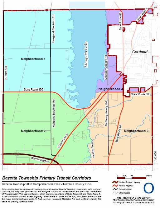
107 Transportation 99
108 The Ohio Department of Transportation published data for 2008 concerning traffic flow for highways and interstates throughout the state. State Route 5, State Route 305, State Route 82, and State Route 46 were all included in this study. The Average Annual Daily Traffic count was taken for each of these highways. The merged portion of State Route 82 and State Route 5 had the highest traffic flow in the township with approximately 28,360 vehicles in average annual daily traffic. The remaining portion of State Route 5 ranked second in highest traffic flow in the township. State Route 305 and State Route 46 were similar to each other with traffic flows between 3,000 and 7,000 vehicles. Traffic Crashes The Ohio Department of Safety records and publishes traffic crash information by township. Bazetta Township reported 238 crashes in 2006, which is the lowest number of crashes reported in the last five years. Despite the increase in traffic and residents, the township has actually experienced fewer accidents. The average number of crashes per year in the township is 278 (based on a five-year average). Bazetta also averages one crash fatality, 102 injuries, and 201 property-damage-only crashes per year. Year Bazetta Township Total Crashes Ohio Department of Safety (Fig. 25) Fatal Crashes Injury Crashes Property Damage Only Crashes Unknown Crashes Total Crashes Deaths Injuries Public Transit Bazetta Township has access to a number of public transit programs provided by both private and public sources. Most prominently, Bazetta joined with the Niles Trumbull Transit System in The Niles Trumbull Transit System provides transit to riders who schedule ahead their trips needs. Riders paid a discounted rate, as Bazetta was a participating community of the system. Transportation is available seven days a week; time varies depending on day of the week and holiday schedule. The township did however vote to reject the 2008 contract with the Niles Trumbull Transit System. The primary reason was lack of resident participation. Although Bazetta has terminated the partnering contract with the Niles Trumbull Transit System, ridership is still available although at a higher rate. Other transportation resources that are available to the township include C.A.T.S. (Community Action Transportation System and Dial-A-Ride. C.A.T.S. does a significant amount of work under a variety of programs, many of which are under a contract with them. C.A.T.S. is Transportation 100
109 organized and ran under TCAP (Trumbull County Action Program). Dial-A-Ride is for citizens over the age of 60, and provides this demographic group with transportation for a variety of reasons including errand running (groceries, bank, etc) and medical appointments. Additionally, the county is serviced by a number of small taxi services including New Valley Taxi, USA Taxi, and Deluxe Transportation. Railroads Bazetta Township has one active railroad running through the center of the township in a northeastern orientation, which eventually crosses through Cortland City. The rail line extending north from the Bazetta Road crossing is owned by Norfolk Southern. This is referred to as the Niles Secondary. Currently the line sees minimal train traffic. According to Rudy Husband, Media Relations - Norfolk Southern, the train traffic is so light that counts are not kept. Presently there are no regularly scheduled trains on this portion of the line, although the lines are able to support nearly all forms of rail transportation and cargo. The southern portion of this line, from Bazetta Road southward, is owned by Ohio Central, a shortline railroad, and is known as the Youngstown Belt. This line is active throughout Warren City and areas south. Most of the use is transportation of steel, lumber, and plastic pellets. Very little of this activity actually occurs in Bazetta Township, as most trains run from the southern United States to Warren City. Transportation 101
110
111 Housing and Neighborhoods Bazetta Township is located in the center of Trumbull County. It is just north of Warren City. The City of Cortland occupies the majority of the northeastern section of the township and Mosquito Lake divides the northern portion of the township in half. The township is primarily rural, but is experiencing significant growth both residentially and commercially. The road network in Bazetta Township often follows a north/south and east/west grid pattern. This is especially true of the majority of the roads save those in the newer residential developments. The most notable exception to this rule is State Route 5. Being one of the earliest major roads in the township, State Route 5 connects the City of Cortland with Warren City and the surrounding urban areas. This corridor is the most significant area of growth in the township. As with many rural roads, many of Bazetta Township s roads bear names of past landowners. Hoagland Blackstub and Durst Clagg are two examples of roads being named after former landowners whose properties abutted the road. Other roads in the township bear, in full or in part, connecting names. Niles-Cortland Road is the local name of State Route 46, and as its name suggests, the road connects Niles and Cortland cities. Warren-Meadville and Everett Cortland Hull are partial landowner and partial location road names. The major developments in the area tend to have road names related to a theme for the development, such as Timber Creek s nature theme: Beaver Trail, Timberline Drive, and Quail Run Drive. Housing Stock Analysis The physical condition of housing was surveyed in the township in the winter of 2008 using a windshield survey method. Housing units were deemed sound, deteriorating, or dilapidated using the 1960 Census of Population and Housing Criteria. The following excerpt features the exact definitions used Census of Population and Housing Structure Characteristics Sound housing is defined as that which has no defects, or only slight defects, which normally are corrected during the course of regular maintenance. Examples of slight defects are: Lack of paint; slight damage to porch or steps; slight wearing away of mortar between bricks or other masonry; small cracks in walls, plaster, or chimney; cracked windows; slight wear on floors, doorsills, doorframes, window sills, or window frames; and broken gutters or downspouts. Deteriorating housing needs more repair than would be provided in the course of regular maintenance. Such housing has one or more defects of an intermediate nature that must be corrected if the unit is to continue to provide safe and adequate shelter. Examples of intermediate defects are: Holes, open cracks, rotted, loose, or missing material over a small area of the foundation, walls, roof, floors, or ceilings; shaky or unsafe porch, steps, or railings; several broken or missing windowpanes; some rotted or loose window frames or sashes that are no longer rainproof or windproof; broken or loose stair treads, or broken, loose, or missing rises, balusters, or railings of inside or outside stairs; deep wear on doorsills, Housing and Neighborhoods 103
112 doorframes, outside or inside steps or floors; missing bricks or cracks in the chimney which are not serious enough to be a fire hazard; and makeshift chimney such as a stovepipe or other uninsulated pipe leading directly from the stove to the outside through a hole in the roof, wall, or window. Such defects are signs of neglect, which lead to serious structural deterioration or damage if not corrected. Dilapidated housing does not provide safe and adequate shelter and in its present condition endangers the health, safety, or well-being of the occupants. Such housing has one or more critical defects, or has a combination of intermediate defects in sufficient number or extent to require considerable repair or rebuilding, or is of inadequate original construction. The defects are either so critical or so widespread that the structure should be extensively repaired, rebuilt, or torn down. Analysis of Housing Conditions The physical condition of housing has a definite influence on the quality of life for citizens of an area. To a certain extent, it is also a reflection of the economic welfare and poverty level of the population. It has been shown in the past that certain housing conditions, such as overcrowding (more than one person per room), lack of sufficient light and air, close proximity to neighbors, lack of necessary plumbing, and lack of adequate kitchen facilities, can lead to higher costs for the community. More police and fire protection may be needed, as well as more health and social welfare work. Revenues from property taxes will also be lower. The housing stock in Bazetta Township is remarkably sound considering the quantity and age of many of the homes in the township. Five homes in the township were in enough disrepair that they were flagged as deteriorated. Most of these homes had multiple issues with windows missing or broken, in addition to above average wear and tear on the outside of the home. Four homes in the township were flagged as dilapidated, meaning the home is not safe for shelter in its current state. Two of these homes were clearly destroyed as the result of fire, the other two are presumably empty as excessive overgrowth dominates the homes. In terms of a spatial pattern, all of the homes, except one, are located on the west side of Bazetta Township. As less new construction has occurred in this area than on the east side, it is not surprising that the homes are older and falling into disrepair. Of these homes, three are located north of State Route 305 and five are located south of State Route 305. The only home located on the east side of the township is one that has most likely fallen into disrepair due to abandonment, not age. The lack of a cluster of deteriorated homes could be construed to indicate that no major areas of deterioration have occurred due to financial constraints of owners in a low-income neighborhood. No significant geographical pattern exists concerning these homes, other than that they are nearly all found in west Bazetta. Additional statistics help to provide a more complete assessment of the Bazetta Township housing stock. The following tables and data are from the 2000 U.S. Census for the township unless otherwise indicated. The first table provides information related to the age of housing in the township. The highest percentages of homes built in the township were constructed in the 1990s. Between 1990 and 1999, 689 homes were constructed, constituting percent of the housing stock. Despite these peak years, nearly half of the homes in the township were constructed between 1950 and This is nearly consistent with the local, state, and national Housing and Neighborhoods 104
113 trends related to residential suburbanization following World War II. The housing units constructed during this period are most often located in subdivisions and are most often in sound condition. The 6.36 percent of homes constructed prior to 1939 are most likely found spread throughout the township as most subdivisions developed later in time. Generally, homes of this age either have fallen into rather bad disrepair or have been carefully maintained by the owners. Year Structure Built, 2000 (Fig 26) Year Built Number of Housing Units Percent of Total Built 1999 to March Built 1995 to Built 1990 to Built 1980 to Built 1970 to Built 1960 to Built 1950 to Built 1940 to Built 1939 or earlier Total Housing Units 2,721 - Since the most recent census data is from 2000, it is important to consider more recent information sources. In terms of collecting data about the newer housing stock, the Trumbull County Building Department provides a list of permits issued in the township, which indicates the intention to construct a home. By sorting through the multitude of permits issued each year, information on the number of residential home building permits can be gleaned. According to this data, the number of houses constructed each year is significantly lower than in the past. Much of this can be attributed to the economic depression the market has experienced in the years since Additional differences might also be ascribed to the different data sources. Residential Building Permits Issued by the Trumbull County Building Department (Fig. 27) Year Number of Building Permits As of the 2000 Census, the median year that housing units were constructed in Bazetta Township is 1976, meaning that approximately one-half of all existing units were constructed before 1976, Housing and Neighborhoods 105
114 and the other half of the housing units were constructed after The median year for home construction in the whole of Trumbull County is This further illustrates that Bazetta experienced growth well after the peak experienced by the more heavily populated regions of the county. This also indicates a certain degree of urban sprawl. The median year for home construction in Warren City is Since the overall population of the county has declined, this data suggests that the population is moving away from the urban centers into the surrounding townships. Beyond population demographics, census information such as housing characteristics can be useful for planning purposes. It is very important to understand the local housing stock, including its size and age, in order to plan for the future. This information is analyzed in further detail in the Housing and Neighborhood section of the inventory. The following chart gives an overview of the housing trend in the township. Reflecting its population growth, Bazetta Township is in fact increasing the number of housing units to support the growth of population that it has experienced. Likewise, Cortland has done the same in the previous ten years. Also similar to their respective population trends, Warren City and Youngstown City have experienced a reduction in the number of housing units as they have also experienced a loss of population from 1990 to Both counties actually lost population between 1990 and 2000, but at a lower percentage in comparison to the county seats. The number of housing units in the counties has increased but at a much lower percent change than in Bazetta Township. Percent Change in the Number of Housing Units in Select Locations (Fig. 28) Percent Change Bazetta Township 2,131 2, Cortland City 2,233 2, Warren City 21,785 21, Youngstown City 40,802 37, Trumbull County 90,533 95, Mahoning County 107, , Growth and development in a community can be measured by criteria, such as the number of houses that are built. This information can also suggest an increase in wealth as building a new home is typically a sign of improving financial conditions in a household. A significant number of homes have been built after In fact, more homes were built in the 1990s than during any other decade. Bazetta has seen a number of developments grow in the last few decades, especially those on the outskirts of Cortland City. Age of the housing also indicates how old the housing stock is in a given area. Older housing stock is more likely to be in deteriorated condition. If new housing units are being built in an area, it means that there is land available, properly zoned, with public infrastructure, and a market and a desire for people to want to build a house there. The following table notes the number of housing units built during each decade of the mid-to-late 1900s as well as a total of housing units built prior to The highest numbers of housing units were constructed during the 1970s. 173 homes in Bazetta Township were built prior to 1940, which amounts to 2.6 percent of the total number of housing units existing in Housing and Neighborhoods 106
115 Number of Houses Built by Year, 2000 (Fig. 29) Year(s) Built Total Built 1999 to March Built 1995 to Built 1990 to Built 1980 to Built 1970 to Built 1960 to Built 1950 to Built 1940 to Built 1939 or earlier 173 Total 2,721 Vacancy rates reveal the stability and attractiveness of an area. The lowest vacancy reports are located in Census Tract 9309, Block Group 1 and Block Group 3 as these areas reported no vacancy in Census Tract 9309 Block Group 4 reported the highest percentage of vacant units at 10.3 percent. For a reference map, please refer to the Census Reference Map located in the population section of the Inventory. Higher rates typically indicate instability and a declining neighborhood. It is imperative to note here that due to the ever-increasing foreclosure crisis and the resulting home abandonment issues these numbers are likely far higher than in To date though, no formal collection of this information has been gathered. Percentage of Vacant Housing Units, 2000 (Fig. 30) Census Tract Block Group Percentage of Vacant Units Housing and Neighborhoods 107
116 Whether housing units are renter occupied or owner occupied is also important information about an area. Like high vacancy rates, a high renter population can reflect a less stable and attractive area to live in. Of the areas in Bazetta Township with rented housing units, Census Tract 9310 Block Group 4 has the lowest percent of renter occupied housing units at 5.91 percent. Census Tract 9309 Block Group 3 has the highest percent of renter occupied housing units at percent. The following chart and map illustrate this information. Percentage of Renter Occupied Housing Units, 2000 (Fig. 31) Census Tract Block Group Percent Renter Occupied Housing and Neighborhoods 108

117 Housing and Neighborhoods 109
118 Another variable that fluctuates depending on the housing market, but still helps to develop a profile is the value of homes in the area. This information can be compared with the surrounding market. This is especially important as the same home in a different part of the country or even the state can be worth considerably different amounts. In the following chart, selected surrounding townships and cities were compared against Bazetta Township. The value range with the highest percentage of homes in Bazetta was $80,000 to $89,999 with percent of homes in the township having a value in this range. In comparison, Champion Township, Mecca Township, and Cortland City had the $100,000 to $124,999 range as the highest percentage. Quite the opposite was the case in Warren City, whose highest percentage of houses fell in the value range of $60,000 to $69,000. This data appears on the following chart. Additionally, the map after this chart illustrates the values of homes in Bazetta Township. Value of Owner Occupied Homes in Select Locations, 2000 (Fig. 32) Value of Home Bazetta Champion Mecca Cortland Warren Township Township Township City City Less than $10, $10,000 to $14, $15,000 to $19, $20,000 to $24, $25,000 to $29, $30,000 to $34, $35,000 to $39, $40,000 to $49, $50,000 to $59, $60,000 to $69, $70,000 to $79, $80,000 to $89, $90,000 to $99, $100,000 to $124, $125,000 to $149, $150,000 to $174, $175,000 to $199, $200,000 to $249, $250,000 to $299, $300,000 to $399, $400,000 to $499, $500,000 to $749, $750,000 to $999, $1,000,000 or more Housing and Neighborhoods 110

119 Housing and Neighborhoods 111
120 The next housing characteristic table presented shows the type of house heating fuel used by residents based on the 2000 Census. The overwhelming type of heating fuel used by the residents of Bazetta Township is natural gas, with nearly 83 percent of all housing units using gas as the primary heating fuel. This is usually the case where natural gas lines have been extended by the utility company to serve residential customers. It is likely that the remaining 17 percent of households either do not have natural gas service available to them, or prefer some other type of heating fuel. Electricity is the number two source of heating in homes with percent of houses utilizing this source. In 2000, no alternative sources of heating energy were reported, such as solar or geothermal energy. Type of Heating Fuel Housing Heating Fuel, 2000 (Fig. 33) Number of Occupied Housing Units Percent of Total Utility Gas 2, Bottle, Tank, or LP Gas Electricity Fuel Oil, Kerosene, etc Coal or Coke Wood Solar Energy 0 0 Other fuel 0 0 No fuel used 0 0 Another housing characteristic reported by the 2000 Census is the number of bedrooms within a housing unit in the township. This data is an indicator of household size and housing unit size because the number of bedrooms indicate how many persons can comfortably reside in a housing unit. The number of bedrooms in a housing unit can also affect other characteristics, such as the value of the housing unit. Nearly half of the homes in Bazetta Township have three bedrooms and well over half of the homes in the township have three or more bedrooms. The next highest number of bedrooms found in township homes is two bedrooms. Much of the two-bedroom homes total can likely be attributed to the number of condominium units found in the township. Bedrooms in Housing Units, 2000 (Fig. 34) Number of Bedrooms Total Housing Units Percent of Total None One Two Three Four Five or more Housing and Neighborhoods 112
121 Also available through the 2000 Census are housing characteristics related to monthly rents and mortgage costs. In Bazetta Township, the majority of housing units are owner occupied, meaning that the owner of the housing unit resides in that unit. Only 15 percent are rented in the township. This information is often important in relation to the upkeep of the housing stock. Generally owner-occupied housing units are more likely to be in sound condition, since the owner of the unit resides there, is able to make needed repairs more easily, can afford to make the repairs, and is more likely to take more pride in their residence than renters, who only live in their units temporarily, and do not own those units. The following table shows data for the renter-occupied housing units in Bazetta Township. Of the 397 units reported, 319 paid cash for rent, and the remaining 78 did not have cash rent. Over 56 percent of renters paid between $400 and $600 in rent each month. No units were rented for less than $300 and no rents exceeded $1,250 a month. The overall variation in rent is most likely due to the location and size of the rental units and any amenities provided by the property owners. Gross Rent Paid in Cash, 2000 (Fig. 35) Monthly Cash Rent Renter Occupied Housing Units Percent of Total Less than $ $100 to $ $150 to $ $200 to $ $250 to $ $300 to $ $350 to $ $400 to $ $450 to $ $500 to $ $550 to $ $600 to $ $650 to $ $700 to $ $750 to $ $800 to $ $900 to $ $1,000 to $1, $1,250 to $1, $1,500 to $1, $2,000 or more - - The 2000 Census also provided data relative to mortgage status. The status of a homeowner s mortgage is important because it reflects the financial burden placed upon the owner. Homes with a second mortgage and/or a home equity loan are more likely to be heavily burdened with Housing and Neighborhoods 113
122 debt. Of the 1,095 homeowners with a mortgage, 865 or 79 percent have no additional mortgage related debt. However, 21 percent have at least a second mortgage or home equity loan on top of their regular mortgage. Slightly over 36 percent of homeowners own their homes outright with no mortgage. Mortgage Status, 2000 (Fig. 36) Mortgage Status Total Percent of Total Housing units with a mortgage, contract to purchase, or similar debt 1, Second mortgage loan only Home equity loan only Both second mortgage and home equity loan No second mortgage or home equity loan Housing units without a mortgage There is a much wider variation in monthly mortgage costs for homeowners, based on the 2000 Census. There are homeowners paying much higher mortgage costs for their homes than renters are for their apartments or houses, due to the higher value of some of the owner-occupied houses and the ability of a homeowner to afford higher housing costs. Over half of the homeowners pay between $600 and $1,250 a month on their mortgages. Very few homes pay less than $400 or more than $2,000 a month on their mortgages. Selected Monthly Owner Costs for Mortgaged Owner-Occupied Housing Units, 2000 (Fig. 37) Monthly Owner Costs Owner Occupied Housing Units Percent of Total Less than $ $200 to $ $300 to $ $400 to $ $500 to $ $600 to $ $700 to $ $800 to $ $900 to $ $1,000 to $1, $1,250 to $1, $1,500 to $1, $2,000 to $2, $2,500 to $2, $3,000 or more - - Total Housing Units With a Mortgage 1, Housing Units Without a Mortgage Housing and Neighborhoods 114
123 As the country reaches a critical state in the mortgage crisis, it is important to recognize that a dramatic change has occurred since the 2000 Census data was collected. Foreclosures are on a rise that is unparalleled in recent years. As new data emerges, it further becomes clear that the trend is widespread and affects municipalities and unincorporated areas alike. This crisis can affect Bazetta Township in a number of ways. First, a homeowner struggling with making mortgage payments is likely to cease paying property taxes. The loss of property taxes in significant enough numbers can be debilitating to a township dependent on this income for maintaining services to the community. Further compounding this particular problem is the fact that homeowners who are served foreclosure papers tend to abandon the home. Abandoned homes are beacons for trouble. Unfortunately, it is not uncommon to have an abandoned home stripped and destroyed, which aside from the dramatic reduction in the home s worth, it also poses a major safety risk. Pipes can be damaged and cause gas leaks that could very likely trigger an explosion. Such problems create more work for the township police and fire department. Aside from the safety issues and the strain placed on local government, a single foreclosed and abandoned home in a neighborhood is likely to affect the home values of neighboring houses. Additionally, these homes are often placed on the market by the bank after the sheriff s sale creating a saturated market. Although having a wide variety of homes available for purchase is an asset to a township, a balance must be struck to keep the housing market stable. Education and prevention are the keys to helping the foreclosure problems striking the market. Efforts within Trumbull County are well underway and are available to residents of Bazetta Township. However, the township does have at least one action step that can be taken. It is in the best interest of the township to keep track of abandoned homes so that the police and fire station can better monitor them for problems. Prevention is important when attempting to preserve the current housing stock and when protecting the neighbors surrounding a foreclosed and abandoned home. Housing and Neighborhoods 115
124 Neighborhood Analysis As part of the comprehensive planning process for Bazetta Township, the community has been divided into four planning areas representing local neighborhoods. Each planning area or neighborhood has unique demographics, characteristics, future potential, and development issues. These neighborhoods have been defined along natural and manmade boundaries, such as roads and township boundaries. The neighborhoods, as defined and mapped in this section, are used throughout the plan. In Bazetta Township, four major neighborhoods were identified. Neighborhood 1 is primarily located west of Mosquito Lake and north of State Route 305. This neighborhood is very rural and is experiencing the least pressure for development in the township. Neighborhood 2 is primarily located south of State Route 305 and west of Mosquito Creek. This neighborhood is the southern western corner of the township. This particular section was grouped due to its primarily light to medium residential use and because of the tremendous commercial pressure in the area. Neighborhood 3 is located in the southeastern corner of the township. The section is bounded by Mosquito Creek on the east and Cortland in the north. This area is experiencing high residential growth. Neighborhood 4 is a split neighborhood with an area located just north of Cortland City and east of Mosquito Lake and the second area located just south of Cortland City, east of Mosquito Lake, and north of State Route 305. Although these areas are very different from each other, they are most likely to feel pressure to annex into Cortland City and thus should be considered together. Neighborhood 1 By and far, neighborhood 1 is characterized by a rural landscape. Pockets of small residential subdivisions occur here and there, but for the most part, the area maintains a grid pattern road network. Commercial development is limited to a handful of businesses, most of which are located nearest State Route 305. Among the notable deviations from the strictly rural landscape are the residential developments of Lakeshore Drive and Millers Landing and the more heavily populated residential roads of Sterling Drive and Prince Drive. This neighborhood is also home to the Trumbull County Fairgrounds, to one of the cemeteries in the township, All Souls Cemetery, and to the bulk of Mosquito Creek Lake State Park. Along the lakeshore, there are also numerous trails for hiking and horseback riding and campgrounds related to the State Park. This area of the township also has one of the township s two fire department stations, located on Everett Cortland Hull Road. Physically, neighborhood 1 is mostly comprised of wooded areas and cleared (either for present use or past use) farming fields. Though this area is no longer a center of population, the intersection of Everett Cortland Hull Road and Hoagland Blackstub Road was often referred to as Klondike s Corners and at one time even boasted a post office. Housing and Neighborhoods 116

125 Neighborhood 2 Neighborhood 2 is bounded by State Route 305 in the north and Mosquito Creek in the east. Of the three designated neighborhoods in the township, this area is the most diverse in nature. The neighborhood is characterized by several moderately dense residential developments, including a mobile home park located off Durst Colebrook, an apartment complex off Hoagland Blackstub, and a condominium development just off State Route 5. There are a small number of housing subdivisions here as well, but these are generally lower in value and older than those of the neighborhood 3 and the Lakeshore area of neighborhood 1. In addition to the more densely populated areas, this area is also home to several community facilities. Bazetta School, West Bazetta Cemetery, and a Trumbull County MetroParks are located within the area. Another significant characteristic of this neighborhood is commercial and industrial growth. The neighborhood is already home to Delphi, Kmart Distribution, Wal-Mart, and Forum Health Outpatient Clinic. In addition to these major companies, State Route 5 in particular is experiencing commercial growth. With the relocation of the Wal-Mart and expansion into a Super Center, additional growth around this business is expected. Further growth along State Route 5, expanding towards Cortland and along Perkins Jones Road, near K-Mart Distribution and Delphi Packard, should be expected and considered when making plans for the township. Neighborhood 3 Neighborhood 3 is bordered on the west by Mosquito Creek and in the north by State Route 305 and encompasses the entire southeastern corner of Bazetta Township. This area is most notable for residential development and is home to several upper middle class subdivisions. Much home construction has occurred in the previous 20 years. Much of the new growth has been homes of greater value than those in the other neighborhoods in the township. This neighborhood continues to experience the highest pressure for residential development in the township. The following aerial photograph from Google Earth features an example of one of the more recent (within the past 10 to 15 years) residential developments in the township. Bianca Lane, Cornerstone Drive, and Keystone Trail Housing and Neighborhoods 117
126 This area also has a small but significant amount of commercial development as well. State Route 5 and State Route 46 are corridors of development between Warren and Cortland and Cortland and Howland. Pressure for continued commercial development should be expected especially at the township boundaries. Neighborhood 4 Neighborhood 4 is unique from the other neighborhoods in that it is divided into two entirely separate sections and is particularly vulnerable to annexation by Cortland. The northern portion of neighborhood 4 is completely isolated from the remainder of Bazetta Township. Because the area remains unsewered, further encroachment from Cortland has slowed. The area is fairly rural and is primarily residential. The second portion of neighborhood 4 located east of the lake is centered around Warren Meadville, McCleary Jacoby, and State Route 5. This area has a small amount of commercial and industrial businesses and the township park, which features Imagination Station, a large wooden playground for children, and a number of ball fields. The area also has a high percentage of smaller, older homes. Like the northern part of this neighborhood, the area is most likely to feel annexation pressure from the City of Cortland. Evidence of this is found at the State Route 305 and State Route 46 intersection, where two of the four corners have since been annexed to the city. Housing and Neighborhoods 118
127 Housing and Neighborhoods 119
128
129 Sanitary Sewer and Water Facilities The existence and availability of sanitary sewer and water facilities in a community are important factors in the future growth and development that can occur there. Since sewer and water facilities are usually constructed by municipalities for their citizens and businesses or by counties for their more urban areas, many townships are not fully served by public infrastructure. This means that many residents must rely on water wells for potable water and septic tanks for wastewater disposal. While these facilities are often adequate for residential land uses, the lack of public infrastructure can inhibit the location or growth of commercial or industrial land uses. Bazetta Township is served by Trumbull County where sanitary sewer lines exist and by Trumbull County or Warren City where water lines exist. Additional service providers are unlikely due to the central location of the township in the county. For the most part the existing lines service the denser residential neighborhoods and a few focused areas of commercial development. This portion of the inventory serves to describe existing facilities and those currently in stages of construction. Discussion and analysis of future needs of the township will be discussed in the Sewer and Water Facilities Plan portion of this report. Existing Sanitary Sewer Infrastructure Sanitary sewers are affected by a number of unique criteria that do not apply to waste water systems. First, since wastewater is generally not under pressure (like water in water lines), topography must be used to allow for the gravity flow of the wastewater. Without expensive pump stations and force mains, sanitary sewers are limited to certain watershed areas where natural topography and drainage patterns determine where sewers can be constructed and what areas can be served. Also, sanitary sewers must necessarily terminate at a wastewater treatment plant, which must be located along an adequate receiving stream, with sufficient flow to dilute the treated wastewater, carry it away, and not become polluted in the process. The Trumbull County Sanitary Engineer s Office owns, operates, and maintains a wastewater treatment plant along Mosquito Creek in Howland Township. This treatment plant handles the wastewater from the sewered portions of Bazetta Township, as well as areas of Howland Township, the airport area of Vienna Township, and Cortland City. Several large residential neighborhoods in the township have sanitary sewers. Timber Creek and its adjacent development east of McCleary Jacoby, Ivy Hills, and Sterling and Prince Drive are examples of such. Additional locations along State Route 5 (mostly north of Mosquito Creek), the southern most portion of Bazetta Road, the eastern most portion of Perkins Jones Road, and McCleary Jacoby north of State Route 305 are all served by sanitary sewers. The majority of developable land in the township is unsewered at this time. Bazetta Township has three areas identified as part of the Consent Decree with the Ohio Environmental Protection Agency (OEPA). These areas were determined to be areas in immediate need of sanitary sewers due to the severity of the pollution problem that currently exists. Each project is in different stages of completion at this time. Sanitary Sewer and Water Facilities 121
130 Consent Decree Areas of Bazetta Township (Fig. 38) Area Required Completion Date Lakeshore Drive 12/31/2010 East Central Bazetta/McCleary Jacoby/SR /31/2010 Southwest Bazetta Interceptor 12/31/2020 In addition to the consent decree areas, OEPA and the Trumbull County Health Department have determined a significant number of areas to be unsewered areas of concern. A septic system that is determined to be failing is a direct threat to health, often becomes a public nuisance, and is a pollution problem that often leads to contamination of the water supply. Additionally, much of the county does not have soils that are amenable to properly support a septic system (refer to map at the end of this section). Soil limitations can reduce the effectiveness of existing systems and often increase the cost of obtaining effective systems. Combining these two factors indicates an immediate need for sanitary sewers in many areas. This situation is addressed in detail in the Sewer and Water Plan. Current Sanitary Sewer Projects Within the township, a variety of sanitary sewer projects are in various stages of completion. Please refer to the Bazetta Section of the Comprehensive County Sewer Plan Estimated Timeline Map located in this section. The project closest to completion is Northview Road. The second nearest to completion is the East Central Bazetta/McCleary Jacoby/SR 305 sewer project. This project, one of the consent decree areas, was completed in Residents are currently tying in. The Lakeshore Drive project was started the latest of the three and is currently under construction. Also a consent decree area within the county, the project must be completed by December 31, 2010 per the agreement between OEPA and the Trumbull County Health Department. Three petition projects are currently pending in the township, the Cadwallader Sonk neighborhood, the Westview Drive neighborhood, and the Janet, Lynn, and Andrews Drive neighborhood. As the petition process is an important option for neighborhoods who wish to make the upgrade from Home Sewage Treatment Systems, the petition process is illustrated at the end of this section. Sanitary Sewer and Water Facilities 122
131 Sanitary Sewer and Water Facilities 123
132 Water Infrastructure Many areas of the township are serviced by water lines. The final map in this section illustrates Bazetta Township Water Districts. There are still significant areas of the township that do not have access to water lines and thus rely on private water wells. Water lines are important to the growth and development of an area. Properly constructed water lines help to ensure access to a clean water supply for all residents and businesses. Public water is routinely tested and held to standards. The results of the routine tests are public information and are generally published and reported through the water provider. Private wells can often be contaminated and are generally not tested to ensure solid water quality. Public water also guarantees that commercial and industrial businesses are able to receive the level of water pressure needed by that particular company. Currently water is available through Trumbull County, the City of Warren, and Cortland s Well System for a widespread area of the township. Portions of North Park, Bazetta Road, State Route 5 and a small section of State Route 46, as well as all of Johnson Plank, Perkins Jones, and Durst Colebrook have access to water lines. Several of the residential neighborhoods in the township have access to water as well including Prince and Sterling, Ivy Hills, and Timber Creek. Both Trumbull County and the City of Warren obtain water from Mosquito Lake. In fact, Trumbull County purchases the water supply directly from the City of Warren who controls all drinking water from the lake. State Route 5, Ivy Hills, Timber Creek, Perkins Jones, and the southern portion of Bazetta Road are all directly serviced by the City of Water. The remainder of Bazetta Road, Johnson Plank, Durst Colebrook, and North Park are serviced by Trumbull County via a system connected to the City of Warren s lines and monitored by a meter pit located on Bazetta Road. This system is the Bazetta-Champion District. The southern most portion of State Route 46 also has waterlines through Trumbull County that carry water purchased from the City of Warren and is referred to as the Howland Water District. A small section of the township immediately surrounding Cortland in the south, and a very small section north of Cortland, actually utilize the Cortland Well System. Water is supplied to these customers from the well field owned and operated by the City of Cortland. Because such a significant number of the township s population has access to a reliable water supply, the same level of urgency is not found as with the sanitary sewer lines. In fact, for those who rely on private wells for water, the focus on construction of sanitary sewers and removal and/or updating failing septic systems is extremely beneficial. Failing septic systems are one of the greatest pollutants of well water in the township. What has been proposed for the future and what might be considered for future growth of the township is addressed in the Sewer and Water Plan. Sanitary Sewer and Water Facilities 124
133 Sanitary Sewer and Water Facilities 125
134

135 Bazetta Township Police Department Community Facilities and Services The Bazetta Township Police Department was formally organized in 1979, after existing as a constable police force since the organization of the township. Over the years the police department has grown to meet the ever-increasing needs of the township. Currently the department is located on McCleary Jacoby Road on the east side of Mosquito Lake in the central portion of the township. Bazetta Township Police Department Human Structure The department currently staffs six full time officers including a police chief and a sergeant, four part time officers (although, as with most police departments, this number tends to fluctuate), and two part time secretaries. Below is an excerpt table from the 2007 Annual Police Report for the township. This table has been reformatted from the original to show additional summary data and to remove officer names. The data is an overview of each officer, mileage, and the statistics from 2007 of the on-the-job duties. Community Facilities and Services 127
136 2007 Officer Activity Recap (Fig. 39) Officer Vehicle Miles Call for Service Incident Reports Crash Investigations Traffic Citations Individual Arrests Chief 7, Sergeant 16, FT Officer 18,776 1, FT Officer 19, FT Officer 11, FT Officer 28,466 1, PT Officer 2, PT Officer 4, PT Officer PT Officer PT Officer PT Officer 2, PT Officer 4, PT Officer Total 116,754 5,233 1, The 2007 Bazetta Township Annual Report proves to be a thorough overview of the township police department activities saw 554 criminal offenses, 192 arrests, 47 violent crimes, 219 theft offenses, 17 breaking and entering crimes, 17 burglaries, and 530 traffic citations, all of which are a decrease from 2006 with the exception of total number of arrests. To further combat crime, the department set a goal for 65 percent of shifts to be staffed with two or more officers in The final percentage came to 58 percent due to part time staff losses. With proper foresight and planning, the department reevaluated this goal and focused the extra coverage on the afternoon shift, the traditional busy shift. This goal was achieved and exceeded as 79 percent of all afternoon shifts staffed two or more officers. Mutual Aid, Assistance, and Community Outreach Like other townships in Trumbull County, Bazetta Township holds mutual aid assistance agreements with surrounding townships. The township also works closely with Cortland City Police. This cooperation among departments is critical as a portion of the township north of Cortland is completely separated from the remainder of the township by both the city limits and Mosquito Lake. The police force is also a member of the Mahoning Valley Critical Response Team and participates in the Trumbull County Emergency Operation Plan under the Trumbull County Emergency Management Agency. The Bazetta Police Department also experiences a unique challenge each year with the Trumbull County Fairgrounds. Special events held at the grounds, especially the Trumbull County Fair, require additional man-hours to supply adequate protection and services. The department supplies these man-hours directly from the department. Although Bazetta has rights to oversee Community Facilities and Services 128
137 the entire fairground, for the county fair the department generally provides service outside the grounds, and the Trumbull County Sheriff provides services within the grounds. The police department regularly coordinates OVI checkpoints within the township throughout the year. In 2007, four such events were held. In addition to this program, the department also participates in a Police Department Safety Day. Within the Lakeview Local School District, the township police department is also involved in the Safety Day held each year at the elementary school. Financial Aspects Funding for the police department is provided by real estate taxes, personal property taxes, portions of fines and fees from criminal and traffic offenses, grants, and donations. The department also works under contract with the Army Corp of Engineers to provide additional police service to portions of Mosquito Lake State Park. In 2007, this contract was valued at roughly $8,000. The police department has worked diligently over the years to remain free of debt and as of 2007, boasted a $281, carry over. With this balance, $629, in property tax collection, and $20, from additional sources, the department projects a fiscal resource base of $993, for What follows is the 2007 budget status for the police department, from the 2007 Annual Report Year End Budget Status (Fig. 40) Item Projection Actual Difference Salaries $304, $285, $18, Overtime $52, $86, $33, Part-Time Salaries $58, $30, $27, Mechanic Salaries $11, $12, $ Employee Retirement Contribution $103, $102, $ Workers Compensation $22, $22, $ Auditor s & Treasurer s Fees $13, $9, $3, Tools and Equipment $30, $11, $18, Supplies $15, $11, $3, DARE $0.00 $0.00 $0.00 Building Upgrade $0.00 $0.00 $0.00 Contracts Dispatching $34, $43, $8, Insurance $88, $96, $8, Transfer $0.00 $0.00 $0.00 Training $10, $1, $8, Other Expenses $0.00 $1, $1, Unemployment Compensation $0.00 $0.00 $0.00 FICA/Medicare Employer s Share $6, $5, $1, Summary $750, $720, $30, Community Facilities and Services 129
138 The present facilities include a 5,000 square foot department building, which holds a conference room, three offices, records storage, male and female locker rooms, and two public restrooms. This facility however, does not have a holding room for suspects. The property also includes a drive through sally port for vehicle storage and general maintenance. The police department is also conveniently located immediately behind the township fire station that services the east side of the township. The police department currently functions on a vehicle replacement schedule, which generally replaces one vehicle per year and allows for the department to have up-to-date vehicles as well as maintain a well-balanced budget. The department also keeps a thorough inventory list of all equipment owned and used by the police force. Comprehensive and accurate inventory lists allow for the chief to make effective and accurate decisions concerning officer safety equipment, necessary purchases, and balanced budget operations. The following chart is an excerpt from the 2007 Bazetta Police Department Equipment Inventory. Immediately following the vehicle inventory listing is a summarized list of the full 2007 Bazetta Police Department Inventory. Vehicle Inventory, 2007 (Fig. 41) Year Make Model Value 2008 Ford Crown Vic 21, Ford Crown Vic 21, Ford Crown Vic 21, Ford Crown Vic 20, Ford Crown Vic 20, Ford Crown Vic 20, Ford Crown Vic 21, Ford Crown Vic 21, Chevrolet Lumina 16, Oldsmobile Cutlass 2, Radio and Related Equipment Inventory, 2007 (Fig 42) Make Model/Description Quantity Value Motorola HT , each Motorola Rapid Charger Astron Power Supply 1 - Vertex Low Band VX-4000 Mobile Radio Vertex High Band VX-4000 Mobile Radio each Motorola 16 Channel Radio Community Facilities and Services 130
139 Weapons and Related Items Inventory, 2007 (Fig. 43) Make Model/Description Quantity Value S&W Grenade Launcher 1 - Glock Model Cal Pistol each Remington Model 4909 Shotgun each Deluxe Cleaning Kit Remington 870 Mag Spring 2 - Winchester RA40SXT 180 Grain Winchester XB Buck Winchester X12RS15 Rifle Slugs Radar and Related Equipment Inventory, 2007 (Fig.44) Make Model/Description Quantity Value MPH K-55 Radar each MPH K-55 Radar each MPH K-55 Ext. Antenna MPH BEE-III Radar 1 2, Kustom Sig Trooper/Radar each Prec Control Radar Trailer 1 12, Unicorn Traffic Classifier 1 - Investigative Equipment Inventory, 2007 (Fig. 45) Make Model/Description Quantity Value Sirchie Fingerprint Kit Sirchie Print Lifter 14 - Triple Beam Scale 2 - AID Kel-Unit 1 - Bushnell Binoculars 1 - Sirchie MFC100 Latent Kit Lap Top and Related Equipment Inventory, 2007 (Fig. 46) Make Model/Description Quantity Value Dell Inspiron 1300 Laptop each Targus Nylon Laptop Case Targus Leather Case Community Facilities and Services 131
140 Software License Inventory, 2007 (Fig. 47) Make Description Licenses Microsoft SBS Microsoft Windows XP Pro 15 Microsoft Office Microsoft FrontPage Acroprint Timestation PC 1 CD Stomper CD Label Kit 1 HP 4050 Printer Software 1 Visioneer Paperport Software 1 ABS VSS PRO V 3.0A & V ABS VSS PRO V 7/0 5 Diamond Trafman 1 ABS Staff Files 1 ABS Ultimate Business Planner 1 Motorola Mobile Phone Tools 1 Tancite Scene PD 2 Enterprise L View L View Pro ARCS Clemis 5 OCJS OIBRS Software 7 Nikon Nikon View V TSI Evidence Trac 1 ID Networks RMS Package - Kodak Easy Share 5 Miscellaneous Police Equipment, 2007 (Fig. 48) Make Model/Description Quantity Value Progard Push Bumpers 7 - Setina Push Bumpers 1 - Code 3 V-Con Siren #3672L4 8 2, Troy Prod Console 8 4, Setina Ford Vehicle Partition 8 3, Code 3 Strike-Force LB 8 6, Progard Universal SG Mount 8 1, Siren Speakers 9 2, Whelen Responder Rev Light Code 3 90 Strobe Power Supply Watt Strobe Kits Community Facilities and Services 132
141 Misc. Police Equipment cont. Make Model/Description Quantity Value Code 3 Hide-Away Strobes LED Deck/Grill Lights Code 3 Rugged Strobe Heads Cobra LED Lightbar Whelen MGM02COA Messenger 1 1, Polaroid Camera 1 NVL Trunk Organizer PAS PAS IV Alcohol Detector 1 1, Command JAC Bulletproof Vest 2 1, Second Chance Bulletproof Vest 10 5, Blackington Rho-Glo Shirt Badges 13 - Blackington Two Tone Badges Smith-Warren Shirt Badges Smith-Warren Gold Hat Badges Smith-Warren Gold Shirt Badges Blackington Hi-Glo Shirt Badges Webster Dictionary Mug Book/Photos 2 - Silenco Ear Protectors 6 - Video Tapes Training 52 - Leather Shotgun Slings Books Transport Belt 2 - Leg Irons 2 - Lock-All Gun Locker 1 - Stack-On 2-Door Gun Safe ASP Expandable Baton 11 - ASP Scabbard 11 - Bianchi Mace Holder 13 - Def-Tec Pepper Spray 20 - Traffic Cones Fire Extinguishers 9 - First Aid Kit 12 - Meterman Measuring Wheel Rolotape Measuring Wheel 5 - Zoll AED Plus w/ped Pads each Zoll AED Simulator Community Facilities and Services 133
142 Office Equipment Inventory, 2007 (Fig. 49) Make Model/Description Quantity Value Cloth Chair 1 - Metal Desk 1 - Metal Cabinet 2-3 Dwr File Cabinet 1 - Metal Bookshelf 1 - Cole Lateral Files 5 1, Hon 30 x 67 Lateral Files 12 6, Hon 36 inch Lateral Files 4 1, Hon Mobile Files Hon Metal Bookcase Hon 36 inch Round Table Bevis 48x144x29 Oval Table Hon 30x60 Table Hon Executive Chair Hon Manager Chair 4 1, Hon Guest Chair 22 2, Hon Stackable Chair Hon 60x30 Desk Hon Credenza Hon 60x24x29 Desk Hon 60x39 Desk with Return Hon Metal Cabinet Lyon Metal Locker 17 - Brass Coat Rack Anti-Static Mat Filing Stool Projector Screen x48 Dry Erase Board x34 Bulletin Board x24 Bulletin Board x36 Bulletin Board Typewriter Stand x18 Cart x60 Chair Mat x24 Dry Erase Board x24 Dry Erase Board x48 Chair Mat Community Facilities and Services 134
143 Office Equipment Inventory cont. Make Model/Description Quantity Value Fellowes PS55 Shredder Shredex Paper Shredder 1 - Toshiba 1370 Copier 1 1, Toshiba 1350 Copier Stand Richo MPC 4500 All in One 1 7, Swintec Typewriter 1 - Sanyo Transcriber 1 - Sanyo Transcriber M Overhead Projector 1 - Haier 13 inch Color TV Orion VHS Player Symphonic DVD Player Display Board Amano PIX-55 Time Clock Bostitch HD Stapler 2 - ACCO 525 Electric Punch 1 - Staple Remover 2 - Assorted Wall Plaques 10 - Slide Trays 4 - Flip Chart Easel 1 - Rubber Stamps 25 - IBICO Binder 1 - Sentry Model 1100 Safe 1 - Boston Pencil Sharpener Swingline Staple Remover Bookends 6 - Telephone Index Hole Punch 1-3 Hole Punch 1 - Engraver 1 - Seth Thomas Wall Clock Tape Dispenser Desk Organizer 3 - Witt/Safco Wastebasket Swingline Stapler Desk Tray 7 - Key Box 3-3 Pack Hot File Community Facilities and Services 135
144 Office Equipment Inventory cont. Make Model/Description Quantity Value Paper Cutter File Box 1 - Power Supply 6 Outlet 2 - CTX VC700 Monitor 1 - Olympus Cardmedia Reader Micro Inov 4 Port USB Adapter Curtis Surge Protector HP IPAQ 2210 HPC KDS 17 inch Monitor 1 - KDS VS inch Monitor TI 5032 Calculator HON Mobile Files Power Supply 6 Outlet Royal Sovereign NR 1201 Laminator Brother Intellifax Sanyo 25 inch Color TV TDN Computer Workstations each Xerox 17 inch LCD Monitor KDS 5221 Color Monitor each HP 4050N Laser Printer 1 1, Dell 100 BT 16 Port Hub Vivitar Vivicam Nikon Coolpix 800 Digital Camera each Delkin 32MB Compact Flash Card Kodak 64MB Compact Flash Card each Kodak C340 Digital Camera Kodak C330 Easy Shar Digital Camera each Scan Disk 256MB SD Card Toshiba 2GB Compact Flash Card Simple Tec 128MB Compact Flash Card Micro Inov PC Camera Compucessory Computer Microphone Logitec Computer Speakers Compact Flash CR-V7-UC Reader Epson LCD Projector Linksys Wireless Router Linksys Wireless Extender 2 - Delkin Compact Flash Adapter Community Facilities and Services 136
145 Office Equipment Inventory cont. Make Model/Description Quantity Value LG External DVD-RW Straitec Compact Flash Adapter Miscellaneous Equipment Inventory, 2007 (Fig. 50) Make Model/Description Quantity Value Dyson Vacuum Cleaner RS RS800 Heater Rubbermaid 6 Gal Mop Bucket 1 - Table and Chairs Bunn Commercial Coffee Maker Kelvinator Refrigerator Christmas Tree and Decorations Industrial Shelves 4 5, Zep Products Floor Squeegee Zep Products Car Wash Brush Mop Handle 1 - Power on Board 12V Power Supply Work Bench Stanley 100 inch Tape Measure Rubbermaid 33 Gallon Trash Can Arrow T-50 Stapler Westinghouse Microwave Oven 1 - Summary and Future Recommendations The Bazetta Township chief of police finds no major concerns with the ability of his department to service the township in the future. Location, equipment, and resources are adequate to continue proper service. The single high priority problem is future funding. Recent commercial and industrial downsizing, the increasing rate of delinquent property taxes, and pending changes in Ohio tax law, all indicate a continuing loss of revenue for local governments. A major focus for the future will be securing revenue to properly run the police department and other emergency services. The chief has already taken a critical first in this process by ensuring the department runs at or below budget each year. Sources Interview with Police Chief Charles W. Sayers, March 20, Bazetta Township Police Department Inventory Township Amended Certificate of Estimated Resources Bazetta Police Department 2007 Annual Report Community Facilities and Services 137
146 Bazetta Township Fire Department The Bazetta Township Fire Department services the entire area of Bazetta Township, excluding the incorporated portions of Cortland City. The department functioned as a volunteer fire department until 1999 and is presently a traditionally staffed department. Currently, two station houses are open in the township, Station 11 and Station 13. Until 1995, the West Bazetta Township Fire Department was primarily responsible for the west side of the township, and the Cortland-East Bazetta Fire Department serviced the east of the township. In 1995, both the Cortland-East Bazetta Fire Department and the West Bazetta Fire Department dissolved into the Bazetta Township Fire Department. Also at this time, Cortland organized into the Cortland Fire Department, thus formally dividing the fire services between Cortland and Bazetta. Due to the geography of the township, Bazetta has nearly always had two fire stations. Since Mosquito Creek had historically been the dividing line between the two halves of the township, the creation of the lake further split the township into two distinct areas. The department has two fire stations, one on each side of the lake. Station 11 and Station 13 were named so based upon a countywide fire station numbering plan designed to aid when dispatching calls. Fire Station 12 is located in Cortland City. Fire Station 11 is presently located on the corner of Everett Hull and Durst Clagg and was constructed in This property is immediately adjacent to the Trumbull County Fairgrounds. The historical location of the west side fire department has always been roughly in this area, albeit the last location was further down Everett Hull. Much of this was due to the fact that the intersection of Everett Hull and Hoagland Blackstub Roads was a small center of population in the early years of the townships development. This trend was continued after this center of population dispersed as the property the station is currently located on is leased to the township for one dollar for 99 years from the Trumbull County Commissioners. This particular station currently consists of a four-bay vehicle storage area, training room, kitchen, radio room, four offices, day room, and bunkroom. Fire Station 13 is located on McCleary Jacoby, southeast of the intersection of State Route 305 and State Route 5. The selection of this location is due to the fact that the land was donated by a private citizen to the township for such a purpose. This is the newer of the two township fire departments as it was constructed in The station consists of a two bay vehicle storage area, two bunkrooms, day room, and kitchen. Community Facilities and Services 138


147 Fire Station 11 Fire Station 13 Community Facilities and Services 139
148 The previous operation of the two fire stations consisted of both stations being open 24 hours a day 7 days a week, always staffing at least two firefighters each. Due to budget constraints in the past year, the township has been forced to significantly modify this operation schedule. Currently the stations are open every other day, on rotating days, with a staff of three firefighters. Aside from the ultimate goal of consolidation in a central location, the fire department is striving to reopen both stations full time should the fiscal problems be overcome. With both stations operational 24/7, response time and coverage would clearly be increased. Typically, the stations would provide backup to one another, with State Route 5 being the dividing line between immediate responses, meaning Station 13 would handle all calls on State Route 5 and areas east, and Station 11 would handle all calls west of this line. The average response time in for the department is five minutes and twenty seconds. This is excellent compared to the national average of nine minutes. In 2007, the department responded to just over 1,300 calls for assistance. Approximately, 85 percent of these calls were EMS calls. In 2006, 1,428 calls were handled and in 2005, 1,596 calls were responded to. Mutual Aid and Emergency Agreements As with other fire departments in the county, Bazetta does participate in a mutual aid agreement. This is structured so that each call can send out first, second, third, etc. alarms depending on the level of emergency and need. Bazetta s first alarm will request assistance from Cortland, Champion, and Bristol and the second alarm will bring in Howland and Mecca. This plan is coordinated to request help from the nearest and best-equipped stations in an effective and organized manner. The Bazetta Township Fire Department is also a participant in the Trumbull County Emergency Operation Plan developed and coordinated by the Trumbull County Emergency Management Agency. Human Structure The Bazetta Township Fire Department has a staff of 11 full-time fire fighters. However, due to the current financial strains, two of these fire fighters are presently laid off. The full staff of the fire department has been trained according to state standards and are career or level two fire fighters. Currently under state law, fire fighters must also receive continuing training hours to continue certification as a fire fighter. Fire fighters must have 18 hours a year in training. All fire fighters on staff are also trained as paramedics. Every three years recertification must be obtained, and the required training must be completed. Paramedic training is done in conjunction with the city of Cortland. Fire fighter training hours are handled through Bazetta Township. The Bazetta Township Fire Department is also fortunate to have firefighter and EMT instructors on staff, meaning most standard and required training can be completed in house. Equipment and Resources In terms of equipment and related resources, the fire department sufficiently functions within the existing resource base. Hydrants exist in approximately 75 percent of the township. Water tankers bring water on site to locations without hydrants. These areas are limited to Durst Clagg Road, and portions of North Park Avenue and Portage-Easterly. Standard equipment also meets the needs of the township (with the exception of water related equipment), but is subject to Community Facilities and Services 140
149 needing routine replacement. The appendix of this sub-section includes a complete equipment inventory for the fire department. Mosquito Lake provides an unusual challenge for the fire department, as the department is first response to all lake emergencies in the township boundaries. In 2007, the department assisted with roughly seven emergency calls on the lake, most of which were related to water-skiing and jet ski operation problems. Although lake calls do not constitute a large percentage of the emergencies the department handles, the risk posed by the lake and potentially needed rescues warrant addressing all issues concerning the lake. Since the boundary line is not exceptionally clear on the lake, Bazetta and Mecca Townships work closely to assist each other. Perhaps the greatest challenge for the department concerning the lake is the lack of proper equipment. Currently the township has an antiquated boat from the 1950s that is unable to safely function in waves 2 feet or higher. Mecca Township only has access to a small boat, which has limitations on the type of emergency that could be safely handled. During seasonal months the Army Corp of Engineers and the State Park can assist with a boat to reach any emergencies; however during off-season times, the Army Corp typically does not have a boat in the water. Bazetta does have some emergency winter rescue equipment, but would need to call upon other townships for any advanced rescue equipment. In order to be as prepared as possible, the fire department offers ice training yearly for fire fighters. The department is also attempting, in conjunction with Mecca Township, Cortland City, and Greene Township to obtain a grant through the Fire Fighters Assistance Program in order to purchase proper water rescue equipment. Items that would be purchased should monies be awarded include dry suits, an ice rescue sled, life jackets, and rope. Financial Aspects In more recent years the Bazetta Township Fire Department has struggled financially. The department has been over budget for the past two years due in part to increasing wages and overtime and declining revenue. Although a recently passed levy has helped to alleviate some strains, the department is still forced to run with three laid off firefighters and on a modified operation plan with the fire stations. The chief and township trustees are fully aware of the financial constraints and diligently working on achieving a balanced budget and the best coverage the township can afford. The fire department is proactive in applying for potential grant funding. All fire prevention grants that the department is eligible to apply for are pursued. In recent years, the department has received grants to upgrade the ventilation systems in the bay area of both stations and for upgrades for the fire fighters activation alarm system. Additional grants are often obtained on an annual basis. The department has regularly received a $1,000 Wal-Mart Community Service Grant, which is used in full to purchase smoke and carbon dioxide detectors. Additionally, the Energizer Battery Company provides donations of 9v batteries to the department. Both of these resources are used for distribution in the township to elderly and low-income residents. Free battery changes are also offered for township residents and are targeted at the elderly who might have trouble reaching their detectors. Fire prevention is taken very seriously by the department and such donations and grants are critical to assisting in this initiative. Community Facilities and Services 141
150 Most recently, the fire department has been striving to obtain a United States Department of Agriculture (USDA) Rural Development Grant. Although the department is currently eligible for a loan from the USDA, the chief would prefer a grant. Because of the economic downturn in the area in the last few years, there is a likely possibility that the median income for the township has declined slightly. As this is the major reason the township is unable to currently receive a grant, when the 2010 Census information in released in a few years, the chief will reapply for this grant. Should the money be granted, it would be used to construct a centrally located fire station. Additionally, the chief is keeping a close eye on grants available for utilizing green technology. Ideally, a grant from the USDA would become available to the township in a few years, and coupled with the potential for green technology grants, the township could have a brand new, centrally located, and relatively green functioning fire department, the first of its kind in the county. Community Facilities and Services 142
151 Additional Community Outreach Aside from the smoke and carbon dioxide detector distribution and installation, and battery installation, the department strives to be a presence in the community through outreach programs. The department works closely with the police department in putting on a safety day at the State Park each year. This event displays the township equipment, educates the public, distributes safety information, and in general allows for time to approach the safety officials in the township with questions. The fire department is also charged with coordinating annual fire and tornado drills for schools and daycares. Senior citizen programs such as SCOPE or private churches are also able to arrange for presentations from the department on topics such as smoke alarms and carbon dioxide detectors. The department recognizes that community involvement is integral to fire prevention education, and many efforts are made to increase the presence of the department through out the township State Fire Marshal Fire Safety Calendar Contest Tribune Chronicle, October 20, 2008 Community Facilities and Services 143
152 Summary and Future Considerations Before nearly any future considerations, recommendations, or plans can be implemented, the department must achieve a fiscal balance. The chief is striving to balance the budget in 2009 and hopes to carry a balance into The passage of a fire levy on a recent ballot will greatly aid in the achievement of this goal. Upon the success of a balanced budget, the fire chief has several goals to strive for. In the short term, the township would like to upgrade the EMS Units currently in use. This would ideally consist of reducing two older ambulances and purchasing one newer unit. The long-term goals for the township include several proposed policies that would need serious consideration. The two major factors influencing the fire department are location and budgetary issues. In terms of location, the chief recognizes that one centrally located fire station would make a greater impact on safety rather than operating two stations on alternating days on opposite ends of the township. A new central location would need to be very near the major roads in the township, State Routes 305 and 5. Consolidation plans have been considered in the past, but have yet to come to fruition. Locations previously considered include the intersection of Elm Road/State Route 5 and Hoagland Blackstub Road and State Route 5 between State Route 305 and Mosquito Creek. An undertaking of this level would demand significant financial resources to secure a proper location and construct a new station. The precarious fire department budget should benefit long term from such an undertaking. A central location would drastically reduce general utility bills and consolidate equipment. Savings from reducing duplicate equipment ranges from the cost of a copy machine and supplies to that of fire engines and ambulances. Another sweeping proposal that would aid in this same process would be to merge Bazetta Township s Fire Department with the City of Cortland Fire Department. Ideally this would provide savings in major equipment, ex. each department currently has a ladder truck, one would typically suffice, and also in administration costs, ex. one police chief would be paid rather than two. Community Facilities and Services 144
153 Bazetta Township Fire Department Equipment Inventory, 2008 (Fig. 51) Location Description Quantity Engine /2" Adjustable comb /4" Dbl jacketed hose 9 1.5" Dbl female 2 1.5" Water curtain " Adjustable comb. 3 10' x 6" Hard suction hose 4 100' Electric cord 3 12" Pike fiberglass pike pole 1 14' Folding ladder 1 14" Chain saw GPM stinger Pumper 1 2 1/2" Adj. comb. nozzles 4 2 1/2" Cellar nozzle 1 2 1/2" Dbl jacket hose 50' 8 2 1/2" Dbl jacketed hose 10 2" Manual hose clamps 2 2.5" 45 Degree elbows 3 2.5" Caps 5 2.5" Dbl female 4 2.5" Hydrant gate valve 1 2.5" to 1.5" Gated Y 1 2.5" to 1.5" Reducer 1 2.5" x 2.5" Gated Y valve 1 24' Ext. ladder 1 3' Pike pole 1 30 lb. Dry chem lb. Dry chem. ext Min. Scott bottles 3 30 Minute SCBA 7 4' Trash hook 1 4" Bastard adapter 1 4" Blind cap 1 4" Caps 2 4" Hose wrenches 4 4" Piston intake 1 4" Single jacket hose 25' 1 Community Facilities and Services 145
154 Location Description Quantity Engine 11 4" Single jacketed 12 4" Single jacket synthetic hose 13 4" Stortz to 2 1/2" siamees 1 4" Stortz to nst female 1 4" to 2.5" Dbl female watt Diesel generator 1 6 lb. Flat head axe 1 6 lb. Pick axe 1 8 ft. Piercing nozzle 1.5 in. 1 8 lb. Sledge hammer 1 Airhorns 2 Aluminum wheel chalks 2 Bolt cutters 1 Broom 1 Brush fire rake 1 Complete tool box 2 Electronic siren 1 Emergency lights 2 Fire helmets 43 Flat shovel 1 Hack saw 1 Halligan tool 1 Hydrant wrench 1 Jumper cables 1 Light bar 1 Lineman gloves 1 Manual hose clamp 1 Manual siren 1 Positive pressure vent. fan 1 Pry bar 4 Radio heat set 1 Relief valve 1 Rubber mallet 1 Smoke ejector 1 Spade shovel 1 Spanner wrenches 4 Squeegee 1 Stinger ground base 2 Turn out coats 43 Community Facilities and Services 146
155 Location Description Quantity Engine 11 Uni thread adapter 1 Turn out gear coats 43 Turnout boots 43 Ventilation saw 1 Water ext. 1 Squad " Dbl jacketed hose 24 1/2" Electric drill Sedan gal. Water ext lb. Dry chem. ext " Dbl jacketed hose " Hard suction hose 2 2.5" to 1.5" Reducer 1 20 lb. CO2 ext. 1 24' Ext. ladder 1 25" Color television 1 3/4 Length boots 10 3/8" Electric drill 1 35 mm Camera 1 4" Sing jacketed hose 6 5 lb. Dry chem. ext watt Quartz flood 2 8' Step ladder 1 Air compressor 1 Ambulance cot 1 Bunker coats 50 Bunker coats, duck 9 Bunker pants 50 Cardiac monitor 2 Complete set foam 1 Complete set of B/P 1 Copier machine 1 Dell laptop computer 1 Gas sniffer 1 Hydrant wrench 1 IV box 1 Knee high boots 40 Light bar 1 Light bar control 1 Community Facilities and Services 147
156 Location Description Quantity Squad 11 Long spine boards 2 Low band radio 1 Medical oxygen - various sizes 2 Roof ladder 12' 1 Rubber mallet 2 Salvage covers 4 Scanner, 10 channel 1 Siren speaker 2 Tire jack w/ handle 1 Traction splint 1 Video cassette 1 XP-1 immobilizer 1 Ladder ft. Pike poles gpm Pump 1 16 ft. Ext. ladder Ambulance 2 2.5" Dbl. female adaptor 2 2.5" Spanner 2 20 ft. Ext. ladder 1 28 ft. Ext. ladder 1 30 min. Air bottle 1 30 min. SCBA bottle 3 35 ft. Ext. ladder 1 4" Hose clamp 1 4" Spanner wrenches 2 40 ft. Bangor ladder 1 99 Channel high band 1 Adult/ped. resuscitator 1 Air pak 4 Ambulance cot 1 Attic ladder 1 Backboard straps 6 Blood pressure cuffs 3 Cardiac monitor 1 Cascade air system 6 Chief car 1 Child spine board 1 Claw hook bar 1 Computer printer 2 Community Facilities and Services 148
157 Location Description Quantity Ladder 11 Curtains for puppet 3 Emergency flashing 1 Emergency strobe 4 Flexible stretcher 1 Halligan tool 1 Hand puppets 8 Head immobilizers 2 High band radio 1 High band radio head 1 High band radio mic 2 Hydrant wrench 1 Immobilizer 1 IV box 1 Light bar 2 Long spine boards 5 Low band mobile radio 1 Low band radio 2 Low band radio mic 2 MAST Shock pants 2 Mechanical siren 1 Medical oxygen - various sizes 8 Microsoft Drawing program 1 Microsoft Excel 1 Microsoft Works 1 Novel computer share 1 Obese blood pressure 1 On board suction unit 1 Padded meeting room 25 Padded office chairs 2 Portable suction 1 Pro-splints, complete 1 Pry axe w/ sheath 1 Pry Bars 2 PVC pipe for puppet 1 Safety city buildings 21 SCBA 2 SCBA bottle 30 min. 1 SCBA masks 30 Scoop stretcher 1 Community Facilities and Services 149
158 Location Description Quantity Ladder 11 Siren speaker 2 Siren unit, 100 watt 1 Smoke ejector 1 Spare 30 min air 5 Speaker for sound 1 Spot light 1 Stair chair 1 Stokes rescue basket 1 Storage boxes 2 Tool box complete 1 Traction splint 1 Trailer 1 Tri-cycles for safety 6 Ventilation saw 1 Station /2" Navy type nozzle 1 1 3/4" Dbl jacketed hose ton Come-a-long 1 1.5" Comb. nozzle 1 1.5" Dbl poly hose " Dbl. male adapter 1 1.5" Water curtain 1 1.5" Zip lock coupling 2 10 ft. Attic ladder 1 10 lb. CO2 ext ft. 110v DC cord 1 10v ma Charger 1 12 ft. Office center 1 12 ft. Roof ladder 1 12 lb. Sledge hammer 1 14 ft. Ext. ladder 1 15 lb. CO2 ext ft. Rescue rope 1 18" Flat shovel 2 2 1/2" Dbl jacketed hose /2" Navy type nozzle 1 2 ft. x 4 ft. Coffee table 1 2 Inlet deluge set gal. Water 5 2.5" Dbl. female 2 Community Facilities and Services 150
159 Location Description Quantity Station " Dbl. male adapter 1 2.5" to 1.5" Gated y 1 2.5" to 1.5" Reducer 1 2.5" Water curtain 2 2.5" Zip lock coupling 2 20 lb. CO2 extinguishers lb. CO2 Fire 2 3 ft. Plaster hooks 2 3 ft. x 3 ft. End table 1 3 Way electrical 1 30 lb. Dry chem. ext ft. 1/2" Poly rope ft. 3/4" Poly rope 1 35 ft. Ext. ladder 1 4 Channel high band 1 4 Drawer filing cabinets 3 4 ft. Bolt cutters 1 4 ft. x 4 ft. Bulletin 1 4 ft. x 8 ft. Bulletin 1 4 ft. x 8 ft. Chalk board 1 4 Slice toaster 1 4 x 4 Cribbing 12 4" Caps 2 4" Gated y 1 4" Hose ramps 2 4" Siamese 1 4" Sing. jacketed hose 10 4" Stortz 1 4" to 2.5" Reducer 2 4" to 5" Stortz 2 45 Cup coffee makers 5 5 lb. CO2 ext 1 5 lb. Dry chem. ext ft. Sec. 3" dbl. jacket 1 50 ft. Sections 1.5" dbl 2 50 lb. CO2 ext 1 6 ft. LA trash hooks 2 6 ft. Pike poles 2 6 ft. x 4 ft. Conference table 1 Community Facilities and Services 151
160 Location Description Quantity Station 11 6kw Generator 1 7 ft. Meeting room 14 8 ft. Coat rack 1 8 ft. Folding ladder 1 8 ft. Pike poles 2 8 lb. Sledge hammer 2 8" Flat shovel 2 90 Cup coffee maker 1 Acetylene tank 1 Adding machine 1 AFFF 3% 5 gal. foam 4 ALERT Plug 1 AM/FM Radio 1 Ambulance cot 1 Antenna for thermal 2 Antenna tri-pod 1 Ashton-Tate computer program 2 Bathroom sinks 4 Battery chargers 2 Battery powered clock 1 Battery tester 1 Battery water fill jug 1 Bed with mattress 5 Bench grinder 1 Bench vise 1 Bolt cutters 1 Broom w/ handle 1 Building fire alarm 1 Carpet runners 5 Carts for metal chairs 3 Case for thermal 1 Ceiling exhaust units 6 Certificate frames 49 Chain bridges 2 Charger 39 Christmas tree 1 Code 3 siren 1 Coffee maker 1 Communications 1 Community Facilities and Services 152
161 Location Description Quantity Station 11 Computer 2 Computer monitor 1 Computer power 1 Computer printer 1 Confined space rescue 1 Cut off saw 1 Cutting board 1 DC charger 1 Deluge stack tips 1 Desert plates 100 Desk light 1 DeWalt 24v AC/DC 1 DeWalt 24v cordless 2 DeWalt 24v electronic 1 DeWalt 24v NICD 3 Digital camera 1 Dinner plates 100 Double tool chest 1 Drill press 1 Drinking water 1 Dry chem. ext. 1 Electric can opener 1 Electric clock 1 Electric multi. tester 1 Electric typewriter 1 Entertainment center 1 File trays 5 Flashlights 2 Flat head axes 2 Floor buffer 1 Floor creepers 3 Folding metal chairs 82 Ford Crown Victoria 1 Furnace timer 1 Garage door openers 6 Garbage disposal 1 Gas cans 2 Gas stove/oven 1 Gasoline safety cans 4 Community Facilities and Services 153
162 Location Description Quantity Station 11 Generator 1 Generator battery 1 Generator battery pack 1 Generator master 1 Golf Cart 1 Grease guns 3 Grease outfit 1 Guide to IBM computer program 1 Halon fire ext. 1 Handheld lights 4 High band radio 1 Hose hoist 1 Hose roller 2 Hose rope tool 1 Hose strap 1 Hose tester 1 Hose washer 1 Hot and cold pitchers 11 Hotel pak 1 Hotel pak wheels 1 House for pluggy 1 IBM computer program 2 Kitchen cabinets 36 Kitchen fire 1 Ladder belt 4 Ladder truck 1 Life pak battery 1 Lighted medicine 2 Long sofa 2 Low band base radio 1 Low band mobile radio 1 Low band portables 12 Low band radio mic. 1 Low band remote 1 Low band remote mic 1 Medical oxygen - various sizes 6 Metal cabinet 1 Metal lockers 5 Metal rack 1 Community Facilities and Services 154
163 Location Description Quantity Station 11 Metal roll cabinets 2 Metal roll cart 1 Metal work bench 1 Micrografx computer program 1 Microwave oven 1 Misc. pot and pans 15 Misc. rubber stamps 7 Mounted hose rack 1 Multi outer circuit 1 Mystery nozzle 1.5" 1 O2 Fill gauge 1 Office chairs 2 Office desk 5 Office desk chairs 3 Orange road cones 5 Outside advertising 1 Overhead projector 1 Oxy cutting torch 1 Pager 37 Paper hole punch 1 Paper staplers 2 Paper towel dispensers 4 Pick head axes 2 Pick up truck 1 Plastic garbage can 1 Plastic salvage covers 11 Portable flood light 1 Portable grinder 1 Portable hose rack 1 Portable lights 3 Portable VHS recorder 1 Power cord reels 2 Power saw 1 Power supply 39 Program timer 1 Radio box 1 Recoil extension cords 3 Remote control 1 Roll barrier tape 1 Community Facilities and Services 155
164 Location Description Quantity Station 11 Roll-a-way desk 2 Rollaway kitchen cart 1 Rolling floor jack 1 Scanner 3 SCBA cascade refill 5 Scott 45 minute air 28 Scott air pack Scott AV-3000 full 2 Scott rit air pack 1 Scott voice audio 14 Sets silverware 100 Shovels 2 Shower stalls 2 Slide copier 1 Slide projector 1 Slide tape player 1 Smoke ejector hanger 1 Smoke ejector stand 1 Snow blower 1 Snow plow 1 Squad jackets 8 Squeegee w/ handle 1 Stapler 1 Step blocks 4 Stokes rescue harness 1 Table fan 1 Television 25" floor 1 Thermal imaging camera 1 Thesaurus 1 Toilets 4 Training and arson 1 Triple basin kitchen 1 Trophy case 1 Typewriter - electric 1 Urinal 1 Vacuum sweeper 1 VHS electronic tuner 1 VHS fire training tapes 10 Visqueen tarp 1 Community Facilities and Services 156
165 Location Description Quantity Rescue 11 Water ext. 1 Water main wrench 1 Weather monitor 1 Welder with cables 1 Wood cribbing 4 x 4 7 Wooden step ladder 2 1 1/2 gal. Gas can 1 1 1/2' Water curtain 1 1 1/2" Adj. comb. nozzle 4 1 1/2" Cellar nozzle 1 1 1/2" Dbl female 2 1 4" Stortz to nst female 1 Rescue 11 1 gal. Bucket 1 1.5" Dbl male 1 1.5" Dbl Female 2 1.5" Foam nozzle 1 1.5" Foam play pipe 1 1.5" Nozzle " Adj. comb. nozzles " Double 8 10 ft. Attic ladder 2 10 ton Porta power kit 1 10" x 6" Hard suction 2 100' Black nylon rope ft. Electric cord ft. Sections of 4" ' Nylon rope w/ bag 2 12' Pike pole 1 14' Aluminum boat 1 14' Folding ladder GPM stinger 1 16' Hydraulic lines 4 2 1/2" Dbl male adapter 1 2 ton Come-a-long lb. Dry chem. ext " 45 Degree elbows 3 2.5" Caps 5 2.5" Cellar Nozzle 1 2.5" Hose clamp 1 Community Facilities and Services 157
166 Location Description Quantity Rescue " Hydrant gated 1 2.5" Tip to 1.5" tip 1 2.5" to 1.5" Gated 1 2.5" to 1.5" Gated wye 1 2.5" to 1.5" Reducers 5 2.5" to 4" Siamese 1 20 lb. Hydraulic ram psi Air chisel 1 24' Ext. ladder 1 25' Air hose 1 25' Air hose w/ air chuck 1 3 ft. Pipe wench 1 3" Single jacket hose 2 30 lb. Hydraulic ram 1 30 min. SCBA 1 30 min. Spare air bottles Scott watt Quartz flood 2 35 mm Camera 1 4' Stortz to nst female 1 4" Hose wrenches 4 4" Manual hose clamp 1 4" Rubber hose ramps 2 4" Spanner set 1 4" Stortz elbow 1 4" Strotz blind cap 1 4" Strotz to 2 1/2" siam. 2 4" to 2.5" Adapter 2 5' Fiberglass pike pole 1 5 gal. 6% Protein foam 3 5 gal. Boat gas tanks 2 5" Intake valve 1 5" Stortz elbow 1 50 ft. Section of 4" 1 50 ft. Sections 1.5" 8 50 ft. Sections 3" watt Diesel generator lamberdini watt Gas 1 6 lb. Flat head axe 1 60 lb. Hydraulic ram 1 Community Facilities and Services 158
167 Location Description Quantity Rescue Horse boat motor 1 8 lb. Sledge hammer 1 Air bags with controls 5 Air horns 2 Air pak 1 Aluminum wheel chocks 2 Ambulance cot 1 Anchors 3 Appliance hangers 8 Automatic external 1 AWG relief valve 1 Base radio 1 Battery module for laptop 2 Boat ores 2 Body drag hooks 4 Bolt cutters 1 Bouies 3 Breathing air O2 2 Breathing air O2 nipple 5 Breathing air O2 nut 5 Broom 1 Brush fire rake 2 Carbon monoxide 1 CD module for lap top 2 Chains with hooks 2 Chemflex extinguishers 5 Child car safety seat 1 Command board 1 Database 2 Dead blow mallet 1 Dell lap top computer 2 DeWalt 24v electronic 1 Digital projector 1 Electric hydraulic pump 1 Electronic siren 2 Emergency lamps 6 First responder chem. 3 Flashlight 1 Flat shovel 2 Community Facilities and Services 159
168 Location Description Quantity Rescue 11 Floppy disk module 2 Gated Y 6 Glucose monitor 1 Hack saw 1 Haligan tool 1 Hallagan tool 1 Hand light 4 Hard suction strainer 1 Head block 3 High band mobile radio 1 Hoover commercial 2 Hose rope tool 2 Hydrant wrenches 4 Hydraulic cutter 1 Hydraulic reel with Hydraulic spreader 1 Ice picks 4 Jumper cables 1 Large channel locks 1 Large jump bag, orange 1 Life vests 3 Light bar 2 Lineman gloves 2 Low band mobile radio 1 Low band portables 7 Manual siren 1 Microwave oven 2 Mobile radio 1 Multiple line block 1 Nasal airway set 1 Pager 1 Pass devices 56 Pediatric backboard 1 Piercing nozzle 1 Pompier belt 1 Portable 1 Portable cutting torch 1 Portable hydrant 1 Portable radio 1 Community Facilities and Services 160
169 Location Description Quantity Rescue 11 Power chain saw 14" 1 Printer for laptop 2 Pry axe w/ sheath 1 Rechargeable hand 2 Reflective EMS vests 4 Road cones 8 Rubber mallet 1 Salvage covers 2 SCBA 6 Siren box 1 Siren speaker 1 Smoke ejector 1 Soft hotel pak. 1 Spade shovel 2 Spanner wrenches 10 Spare boat prop 1 Spot lights 6 Squeegee handle 1 Squeegee 1 Staple gun 1 Steering wheel covers 2 Stinger ground base 1 Stokes stretcher 1 Tip set 1 Tool box complete 2 Tow chains 6 Uni thread adapter 1 Water ext. 1 Windshield saw 1 Word processor 1 Radio Room 11 31" TV 1 Complete rit kit 1 DVD player 1 Gray office chair 4 Microwave oven 1 RIT belts for SCBA 14 Scott AV-3000 full 26 Scott voice amplifier 14 Small RIT rope bags 14 Community Facilities and Services 161
170 Location Description Quantity Bay lbs. Free weights 4 12 ft. mobile ladder 2 Back rack light holder 1 Cascade system 2 EMS knox box 1 Gas grill with 3 gas 1 GE 14 cycle large 1 GE dryer 2 GE washer 1 GMC 4x4 v6 pickup truck 1 Honda harmony en Lazy boy recliners 4 Low band radio 1 Motorola HT750 High 12 Plow package 1 Power weight rack 4 Pull out bed couch 4 Radio headset 3 Row machine 4 Siren 1 Stair master 4 Strobe light bar with extra lenses 1 Truck bed mounted steel tool 1 Universal weight rack 8 Wood coffee table 1 Wood computer desk 4 Wood conference 4 Wood end table 1 Wood tv stand 1 Dayroom lbs. Dumb bells 4 2 Drawer metal filing 2 4 Drawer filing cabinets 3 4 Drawer metal filing 2 Fixed chairs 4 Fixed office chairs 9 Lap top computer 2 Large weight bars 4 Large wood 6 drawer 1 Large wood desk 1 Community Facilities and Services 162
171 Location Description Quantity Laser Jet Printer 1 Metal cabinet stand 1 Metal lockers 6 Military metal desk 1 Phone 2 Rolling office chair 3 Scanner 1 Twin beds with box 4 VCR 1 Window a/c unit 1 Wood 1/2 size lockers 20 Wood desks 2 Wood end table 1 Wood large size locker 1 Engine 13.75" Nylon hose, 50' 1 1 3/4" Adj. comb. nozzles 2 1.5" Dbl. male adapter 1 1.5" Mystery nozzle 1 1.5" to.75" Reducer 1 1.5" Water curtain 1 1.5" Zip lock coupling 1 1/2" Rescue rope, 100' 1 14' Folding ladder 1 2.5" 45 Degree elbows 1 2.5" Caps 7 2.5" Dbl female adapter 1 2.5" Dbl male adapter 1 2.5" Hydrant gate valve 1 2.5" to 1.5" Gated wye 2 2.5" to 1.5" Reducer 1 2.5" Water curtain 1 2.5" x 2.5" Gated wye 1 2.5" Zip lock coupling 1 3" Dbl jacket hose 50' 1 3" Single jacket hose 1 35 mm Camera 1 4" Caps 1 4" Stortz to nst female 1 4" to 2.5" Dbl female adapter 1 Community Facilities and Services 163
172 Location Description Quantity Engine 13 4" to 2.5" Dbl male adapter 1 4" to 5" Stortz adapters 2 5 gal. 6% Protein foam 3 6 lb. Pick axe 1 Air chuck 1 Barrier tape dispenser 1 Barrier tape rolls 2 Chain saw 14" bar 1 Crash axe 1 Electronic siren 1 Foam eductor 1 Foam nozzle 1 Hard suction strainer 1 Hose rope tool 1 Hose strap 1 Hydrant pump 1 L A trash hook 1 Light bar 1 NST bastard adapter 1 Positive pressure vent. fan 1 Pry bar 1 Relief valve 1 Road cones 3 Salvage covers 2 Uni thread adapter 1 Community Facilities and Services 164
173 Bazetta Township Road Department The Bazetta Township Road Department is charged with servicing and maintaining over 20 miles of roads within the township boundaries. The department oversees plowing, patching, proper signage, and clearing road debris, among many other activities. Additionally, the department maintains two cemeteries in the township (Hillside and West Bazetta) and two cemeteries within Cortland City (Casterline and Cortland Christian). The cemetery work consists of burials and upkeep on acres of land, including mowing around 6,000 headstones and along 5,570 feet of fence line. The following chart is a snapshot of the number of hours and work completed from October 2007 until March (Fig. 52) Bazetta Township Road Department Hour Summaries October 2007 November 2007 December 2007 January 2008 February 2008 March 2008 Making house numbers Checking and resolving complaints Removal of debris from road right of ways Administration Meetings Letting water off roadways and storm damage Reports, bills, PO s, and BC s Repairing C/B s Sign inventory, repair, and replacement Working on salt shed Improving bus turnarounds Working in Issue 2/Grants Burials Cleaning equipment Mowing roadsides Checking roads and rights of way for obstructions and potential problems Cold patching roads Cemetery foundations Mowing and maintenance in cemetery Training at YSU Chainsaw safety class Taking truck to cross equipment Community Facilities and Services 165
174 Hour s cont. Oct Nov Dec Jan Feb Mar Hauling grindings from Durst Clagg resurfacing projects 28 Working in park Prepping and painting snow and ice equipment Work at police and/or fire department Cleaning ditch Plowing and salting roadways Total Human Structure The road department employs five full-time employees including the road superintendent, assistant road superintendent, and a mechanic who also works for the police and fire departments. During the winter months, the four road employees spend the majority of time on road related activities. During the summer months, two of these employees maintain the township cemeteries on a full-time basis. Additionally during the summer months, the department employs one part-time worker to maintain the township park. Each employee is also a member of the Teamsters Local 377 Union of Youngstown, Ohio. Financial Considerations The department is funded from the Road and Bridge Fund, Gas Tax Fund, and License Plate Tax Fund. A small portion of funding is also contrived from a.6 mil levy and property taxes. The department runs on a balanced budget each year. The Road Superintendent and department employees are especially efficient at staying within budget and utilizing the resources at hand to a maximum level. From the smallest level, always ensuring that lights are turned off when a room is empty, to saving to pay cash for the majority of purchases, the department works diligently to function on a balanced budget. Facilities and Resources The Bazetta Township Road Department is located at the intersection of State Route 5 and State Route 305. The building currently occupied by the department was formerly the township police station, and even earlier, the town hall. This building consists of a lunchroom, office, and four bay garage. The department also uses two bays located at the township administration building on the same property and a barn for additional equipment storage. A salt shed was constructed in The charts at the end of the road department section are inventory listings for the Road Department, and the cemetery and park, which the department oversees. Community Facilities and Services 166

175 Bazetta Township Road Department Summary and Future Recommendations Bearing in mind the current financial constraints of the local economy, the Road Superintendent feels that the department is fully able to function with the current resource base available. Again, with the unpredictable fiscal future in mind, future recommendations are based upon availability of funds. The township will be in need of a snowplow truck to replace the 1988 currently in use. Since the truck is now surpassing 20 years, a new truck will be budgeted and saved for in the near future. Additionally, the road department will consider the future purchase of a new pickup for plowing intersections and smaller areas that a large snowplow truck cannot efficiently or effectively cover. As with any department, any major increases in funding would immediately beg consideration of staff increases and later construction or addition of additional office and work space. Source: Interview with Road Department Superintendent Frank Parke and Assistant Road Department Superintendent Kris Parke, April 24, Community Facilities and Services 167
176 General Equipment Inventory, 2008 (Fig. 53) Description Quantity Value Mobile Radio Motorola (Truck 33) w/ Antenna 1 1, Mobile Radio Motorola (Backhoe) w/ Antenna 1 1, Mobile Radio Motorola (5000 Ford) w/ Antenna 1 1, Mobile Radio (Truck 30) w/ Antenna Mobile Radio (3600 Ford) w/ Antenna Midland Radios (Pickup and Taurus) each Tait Radio (Truck 2) Vertex Radio (Van #15) Uniden BearCart Scanner Stihl Saw Model 192-T 1 - Kenwood Radio (Truck #4) John Deer 1 5, Chevy S-10 Pickup 1 - S-10 Radio Vertex Chevy Pickup , Spare Tire & Wheel (Unit #30) International Dump Truck w/ Snowplow 1 67, Fire Extinguisher International Cab & Chassis w/ Dump Body 1 38, Ford One Ton 1 35, Kenwood Radio D Caterpillar Backhoe 1 95, w/ 4 ft. Ditching Bucket 1 - w/ 42 in. Grave Bucket 1 - w/ 24 in. Digging Bucket 1 - Spare Tire & Rim Swanson Spreader 1 2, American Roads Snowplow 12 Ft. Power Angle 1 4, Dump Truck 1 53, Grease Gun Spare Tire & Rim 22" Front Spare Tire & Rim 22" Rear Swanson Spreader 1 - American Roads Snowplow 12 Ft. Power Angle 1 5, Swanson Spreader 1 2, Fire Extinguisher HM Trailer Community Facilities and Services 168
177 Snow Plow Accessories Inventory, 2008 (Fig. 54) Description Quantity Value Myers 8 ft. Blade American Blade (3 piece) Snowplow Blade Plus Bolts (Myers 7 1/2) Extra Wausau Nose Pieces for Blades each Wausau Blade Shoes 5 - Water Pump Equipment Inventory, 2008 (Fig. 55) Description Quantity Value 3" Midland Water Pump 1 1, Feet 3" Hard Suction Hose Feet 3" Soft Hose " Strainer /2" Water Pump I & Rand Feet 1 1/2 Hard Suction w/ Strainer 10 - Feet 1 1/2" Soft Hose Honda & 1 1/2 Discharge Hose Hand Tool Equipment Inventory, 2008 (Fig. 56) Description Quantity Value Crow Bar Ft. Square Levels each Hand Saw Chalk Line Dispenser Blacktop Lute Mason Hoe Post Hole Digger Garden Rake Aluminum Rake 2 - Hand Sickle Double Blade Axes D Handle Shovels each Long Handle Flat Shovel each Long Handle Pointed Shovels each Short Handle Pointed Shovels Community Facilities and Services 169
178 Hand Tool Equip. Inventory cont. Quantity Value Mason Trowels each Mason Hammer Hatchet Brush Axe Chain Binder each Sign Post Driver Cement Trowel Hand Trowel Float Homelite HB 390V Classic Leaf Blower Cement Edger each Hoe Spud Bar Carpenter Hammers each Hacksaws each Hay/Pitch Fork Power Tool Inventory, 2008 (Fig. 57) Description Quantity Value EG5000 Honda Generator 1 1, Cart for Generator Stihl Brush Cutter HT Stihl 019T Chain Saw Stihl 026 Chain Saw Stihl 046 Chain Saw Milwaukee Skill Electric Saw Shop Vac Wet/Dry Eureka Sweeper Makita 14.4 Volt Cordless Drill w/ Chargers Milwaukee Saws All 1 - DeWalt Cordless Sawsall Community Facilities and Services 170
179 Sign Inventory, 2008 (Fig. 58) Description Quantity Value Bazetta Township each Low Clearance 1 Reserved Parking (Handicap) 2 Yield on Left Turn 1 Yield on Left Turn No Parking Dry Hydrant 1 Bump each 3-Way Stop each 4-Way Stop 2 Curve Signs 11 Reserved Parking Beyond This Point 1 25 mph 12 x each Authorized Vehicles Only 1 45 mph Stop Ahead 1 No Parking School Bus Turnaround each Left Lane Must Turn each Right Lane Must Turn each Speed Zone Ahead Chevron's 12 x 8 2 No Firearms Signs 5 No Parking Any Time 3 10 ft. Sign Post 25 8 ft. Sign Post 1 Mowing Ahead 2 Target Enforcement Area 3 School Bus Turnaround Flagman Ahead Men Working 2 Street Name Signs each Deaf Child Area each Intersection 1 - Fire Station Ahead each Emergency Snow Route 3 - T Warning Sign 1 - Hidden Drive 1-25 mph Sticker Facings 11 - Community Facilities and Services 171
180 Sign Inventory cont. Quantity Value Stop Sign Sticker Facings 8 - Traffic Signal Ahead 1 - Road Closed each No Fishing From Bridge each Arrows each Stop Signs 30" 12 - Stop Signs 36" 1 - Handicap Rest Rooms 4 - Crime Watch 6 - Miscellaneous Equipment Inventory, 2008 (Fig. 59) Description Quantity Value 3/8" Chain 4 - Tow Chains 5/ each 8' Step Ladder ' Step Ladder 1-12" Aluminum Extension Ladder ft. Water Hose each Sets of Raincoats w/ pants and jacket each Pair Boots each Portable Work Signs each Mop Bucket Laser Plane L220 Leveling System w/ Tripod 1 1, Transit Bostrom 200 B Story Pole Road Cones 18" (Old/Red) 19 - Road Cones 18" (Green) each Metal Bushel Baskets each 5000 Ford Tractor 1 7, " Side Versa Road Mover 1 3, Side Versa Ditcher 1 3, Ford One Ton 1 23, /2 Meyer Plow Model C ft. Single Auger/Salt Spreader 1 2, " Trailer 1 8, ft. Desk Swivel Chairs each Chairs each Community Facilities and Services 172
181 Office Inventory, 2008 (Fig. 60) Description Quantity Value 8 ft. Table ft. Table- Wood ft. Table ft. Group Locker Mac 51-B Magnetic and Cable Locator 1 1, Stihl Concrete Saw w/ Cart 1 1, Hewlett Packard HP Desk Jet 940C Drawer File Cabinets 5 13" Emerson TV VCR Tennsco Storage Locker Tool Cabinets (Wall Hanging) each Myers 8 ft. Snow Plow 1 2, Hewlett Packard 890C Printer Hewlett Packard 5610xi 1 Compaq Notebook Computer 3 Campbell/Housfeld Hi Pressure Waster (Cold Water) Hi-Pressure Sewer Cleaner 1 10, Bunn Coffee Maker VPR Shoe 1 Gateway 2000 & AOC Monitor 1 Hose Keeper Roller Shoe Hi-Pressure Gun 25 ft. of Hose ft 1/2" x 2000 psi Lateral Sewer Hose /4" Root Cutter Kit psi Short Nozzle Button 1/2" x /4 Tube Style Ext Nozzles 3/4" Tractor Mower 1 8, Grading Blade ft. John Deer Brush Hog Back Blade Float Ford Lawn Tires " Woods Mower 1 1, Rock Rake Harley Rake 1 4, A Frame Plastic Barricade each A Frame Barricades each Community Facilities and Services 173
182 Cemetery Equipment Inventory, 2008 (Fig. 61) Description Quantity Value 1965 Massey Ferguson 1 5, " Digging Bucket Foot Digging Bucket Foot Digging Bucket Lawn Roller Homemade Dump Trailer Gallon Gas Can each 2 Gallon Gas Can Tree Trimmer Saws each Lawn Rakes each Long Handled Shovel Pick Grease Gun Gallon Sprayer Dual Tire Wheelbarrow Short Handled Shovel each 38 Piece Socket Set Crescent Wrench each Set Wrench each Screwdrivers Hammer Wire Cutter Pliers Scraper Heater Gallon Funnel Additional Funnels Stihl HS80 Trimmer Stihl FS80 Pro Series Weed Eater each Push Broom 1 - Post Hole Digger 1 - Car Ramps 1 - Water Loo Tool Box (Top Piece) 1 - Ransom Bobcat Mower by Textron 1 - Troy Built Tiller 1 - Garden Rakes 1 - Community Facilities and Services 174
183 Cemetery Equip. Inventory cont. Quantity Value Spud Bar Ransom Bobcat Mower by Textron 1 - Lawn Sweeper 1 - Township Park Inventory, 2008 (Fig. 62) Description Quantity Value Picnic Tables each Push Broom Spade Shovel 2 - Flat Shovel 1 - Strings of Christmas Lights 10 - String of Icicles 1 - Garbage Cans 7 - Strings of Lights w/ Star 1-2 Gallon Sprayer 2 - Deer 5 - Sleigh 1 - Litter Picker 1 - Angel 1 - Pitch Fork 1 - Garden Rake 1 - Leaf Rake 1 - Wheelbarrow 1 - Bolt Cutters 2 - Weed Whacker Stihl FS American Flag (Lights) 1 - Spud Bar 1 - John Deer " and 60" Mower 1 9, Water Loo Tool Box (Bottom Piece) John Deer 1 4, Back Pack Leaf Stihl Blower BR Community Facilities and Services 175

184 Parks and Recreation Bazetta Township is ideally located in relation to recreational activity. Although the township itself only owns and oversees one public park, multiple recreational activities are easily accessible both within and very near the township boundary. As opportunities for recreation are very important to the quality of life for residents, this section will review the current existence of such locations. The Bazetta Township Park is located adjacent to Mosquito Lake State Park just northeast of the intersection of State Route 305 and Warren-Meadville Road. The park is a little over 10 acres and features 2 ball fields, 2 pavilion style shelters, a gazebo, and an extensive playground, Imagination Station. The park is owned and maintained by the township. Future plans for the township park include considerations for a soccer field, outdoor ice-skating rink, or perhaps nature trails. The township is also considering purchasing a small lot of land on the north side of the park to aid in future park expansion. Bazetta Township Park Entrance Community Facilities and Services 176


185 Gazebo Imagination Station Community Facilities and Services 177
186 Aside from the township maintained park, Bazetta plays host to the most significant, both in size and in scope, park in the county, Mosquito Lake State Park. The full scale of the state park amounts to over 2,400 acres of recreational park land, the most developed of which are located in Bazetta Township. The lake itself encompasses roughly 4,000 acres of land in Bazetta, Mecca, and Greene Townships. Permitted activities include camping, hunting, fishing, horseback riding, hiking, swimming, picnicking, boating, and winter activities including snowmobiling, ice skating, and cross country skiing. Bazetta Township is also home to one of the newest additions to the Trumbull County MetroParks, the Mosquito Creek Nature Preserve. Located on State Route 5, this 136-acre park is currently not open to the public, but is slated for future development with intent to open. The property is limited in recreational development opportunities due to the nature of the purchase agreement and the fact that much of the land is wetlands. Despite these deterrents, the park could be opened with trails, an arboretum, or ultimately one day connected to Howland Township via a boardwalk spanning the Mosquito Creek Corridor. Most importantly, an additional recreational opportunity for the residents of Bazetta Township is on the horizon. Additional private recreational activities are also abundant within the township. As with the remainder of the county, within Bazetta there are a number of golf courses. The following chart illustrates the presently operating golf courses in the township and the amenities offered at each. Bazetta Township Public Golf Courses (Fig. 63) Course Holes Clubhouse Cart Rental Club Rental Driving Range On-Site Pro Snack Bar Retail Shop Ash Hills Golf Course 2544 Niles Cortland Rd NE 9 x x x x Longview Golf Course 375 State Route x x x x x x Tamer Win Golf & Country Club 2940 Niles Cortland Rd NE 18 x x x x Sources: Trumbull County Tourism Bureau, Trumbull County MetroParks Community Facilities and Services 178
187 Existing Land Use The existing use of land in a community is a key component in beginning to plan for the future of that community. Understanding how land is used, and also why and where, helps to identify spatial patterns and trends that should be continued or modified based upon analysis and citizen input. The mapping of existing land use provides a unique snapshot of current conditions that is also comparable to communities of similar size and location. There are many factors that affect the way land is used in a particular community. Land use is often dependent on a specific site s geographic location, its proximity to transportation facilities, urban areas, water and sewer facilities, or physical characteristics such as soils, wetlands, or groundwater resources. Beyond its geographic location, there are social factors such as demographics, the size of population, and the attitudes of local residents toward certain types of development. After existing land use is inventoried, mapped, and analyzed, certain conclusions can be drawn toward the best possible use of land in the future. In determining potential future land uses, it is always important to identify the existing land uses that are adjacent or near to the site, so as not to plan a future use that would be in conflict. For example, it is never practical to plan a new industrial development adjacent to a sound residential neighborhood without some kind of buffer. Also vital to the planning effort is understanding the existing physical characteristics and the availability of public infrastructure at the site. Methodology for Existing Land Use Survey In early 2008, the staff of the Trumbull County Planning Commission conducted a windshield survey of land use in Bazetta Township. GIS maps that included parcel boundaries and building footprints were used in the field. In order to identify the existing land use for each property, the staff drove or walked along every street in the community annotating the type of land use for each property. During the same field survey, the staff also listed the condition of the housing on each residential property. Housing condition information is discussed in the Housing and Neighborhood Analysis section of the inventory. In order to classify the land use for each property, a code was marked on each parcel denoting what type of land use was in existence during the survey. Abandoned or empty properties were marked according to visual evidence of the last existing land use. The land use codes were as follows: Existing Land Use 179
188 Land Use Codes (Fig. 64) Code RS RM RMH COP CR CS I PC PE PG PR PU Category Residential Single-family Residential Multi-Family Residential Mobile Home Commercial Office Professional Commercial Retail Commercial Service Industrial Public Cultural Public Educational Public Governmental Public Recreational Public Utility Residential Single-family homes are one family homes or single mobile homes on one lot. Residential Multi-Family homes include duplexes, triplexes, condominiums, and apartment complexes. Residential Mobile Home is limited to organized and managed mobile home parks. Commercial Office Professional includes medical facilities and professional offices such as insurance companies and income tax services. Commercial Retail includes locations where an item is purchased and taken from the premise such as a convenience store or car lot. Commercial Service includes locations where a service is rendered or dispatched from such as a mechanic shop or carpet cleaning company. For this particular survey, dine-in restaurants were deemed service. Industrial is typically limited to manufacturing or heavy-duty production. Public Cultural includes worship facilities, cemeteries, and other culturally specific entities. Public Educational includes schools and other educational facilities. Public Governmental includes all local, state, or federally owned buildings such as administration buildings, town halls, fire stations, road departments, and police stations. Existing Land Use 180
189 Public Recreational includes most recreational opportunities whether private or public. A typical example of this land use is a golf course. Public Utility includes power stations and utility related buildings. It is important to note that land use does not always reflect zoning regulations. In many instances land might be zoned residential; however the land is not currently in use and is simply open space. Other examples of this include a land use that was grandfathered in to a newer zoning regulation or a land use that is simply not in compliance with zoning regulations due to lack of enforcement. For this reason it is wise to compare existing land use with current zoning regulations to check for compliance on a regular basis. The existing land use pattern in Bazetta Township is diverse and encompasses many different types of activities. State Route 5 is the primary focal point for commercial activity in the township, while the State Route 82 and the Larchmont/Perkins Jones intersection is more of an industrial center in the township. Most other areas of the township have widespread residential land use. Due to the ever-increasing population base, housing stock, and industrial/commercial development, the township has less open space than the other third tier townships in Trumbull County (Southington, Champion, Fowler, and Hartford). One of the largest land uses identified is residential single-family. The majority of properties used for housing are located in residential subdivisions. However, significant residential growth has occurred throughout the township and can be found along every road located in Bazetta. Because so many of these developments are newer, most homes have larger lots. Lot size does vary significantly outside of subdivisions as many homes are located on farms or land that previously functioned as such or are located smaller parcels of land split and sold from farmland. The vast majority of the housing is single-family, although there are two mobile home parks and several pockets of condominiums and apartments scattered throughout the township. Public recreational land use tends to cover significantly more area than land being used for commercial or industrial purposes. Often this is because the recreational use is for golf courses or hunting clubs. This is true in Bazetta Township. Additionally, Bazetta Township is home to both the Trumbull County Fairgrounds and also to Mosquito Lake State Park, which amount to a significant number of acres in the township. Commercial service and commercial retail land uses have a strong presence in the township. Currently these land uses are focused along State Route 5 and State Route 46, although spotted amounts of commercial activity are appearing in other areas of the township such as around the State Route 82 and Perkins Jones intersection. These areas should be reviewed often to ensure that proper zoning regulations are being followed. Additionally, because of the growth occurring and because of future anticipated growth, the zoning in these areas should be in line with the needs and desires of the township. Existing Land Use 181

190 Existing Land Use 182
191 Land Use by Neighborhood In order to better understand the spatial distribution of land use in Bazetta Township, an analysis by neighborhood has been undertaken. The township has been divided into four planning areas representing local neighborhoods. The complete breakdown and description of each neighborhood is located in the Housing and Neighborhood Analysis section of the inventory. Neighborhood 1 is located north of State Route 305 and west of Mosquito Lake. Neighborhood 2 is located south of State Route 305 and west of Mosquito Creek. Neighborhood 3 is located east of Mosquito Creek and south of State Route 305. Neighborhood 4 is the area north of the City of Cortland and the land north of State Route 305 and south of Cortland. Neighborhood 1 Neighborhood 1 is the most rural area of the township. Aside from the Trumbull County Fair Grounds, Mosquito Lake State Park, and a golf course, nearly all land in use is residential. A few spots of commercial retail and service activity are scattered around the countryside. The residential land use in this neighborhood is nearly all single-family, save a few widely dispersed duplexes. Three residential subdivisions are found in this neighborhood, the Lakeshore Drive area, Sterling, and Prince. All other homes line historic country roads in this area. The primarily residential land use in this area is not surprising as development immediately north and west is minimal as well. Aiding in this pattern is the lack of sanitary sewers in the neighborhood. The residential subdivisions do have or are in the progress of having such facilities available; however the vast majority of the neighborhood relies on Home Sewage Treatment Systems. Not having proper sanitary sewer lines could be considered a deterrent to development in an area. Neighborhood 2 Neighborhood 2 is a very active and diverse neighborhood and is prime for future development due to proximity of existing activity and infrastructure. Industrial and commercial land uses are key components to this neighborhood. The most significant development in the township has occurred along the two major roads found in neighborhood 2, State Route 5 and State Route 82. State Route 5 has been the historical focus for activity in the township, outside the City of Cortland, and continues to be so with recent construction occurring along Millennium Boulevard. Residential land use is also strong in neighborhood 2. Single-family homes are widely dispersed throughout the area and are also concentrated in a few subdivisions. What stands unique in terms of residential land use in this neighborhood is the multi-family residential land use. While the neighborhood has a scattered number of duplexes similar to neighborhood 1, this area also features a mobile home park, a large condominium development, and a number of apartment complexes. Availability to such resources as sanitary sewer lines and water lines tends to promote such land use and tends to encourage this type of growth. Existing Land Use 183
192 Neighborhood 3 Neighborhood 3 is the most residential section of the township. Most new home construction occurs in this area, and as a result, significant single-family subdivisions are found throughout the neighborhood. Newer subdivisions include Timber Creek, Cornerstone, and Stonegate. Older subdivisions are also found throughout the neighborhood and include Westview, Northview, and the Morrow Drive neighborhood. Another major land use in this neighborhood includes public recreational. Several golf courses are located in this area, along with other recreational opportunities. State Route 46 and the northern portion of State Route 5 are also located in this area and have a significant amount of commercial service and commercial retail activity located along the roadway. State Route 5 is currently experiencing pressure from expansion extending from Cortland. State Route 46 is experiencing development pressure from Cortland in the north and Howland Township in the south. Due to these pressures, it is important that land use is closely monitored, and proper zoning is in place. Neighborhood 4 Neighborhood 4 is actually two entirely separate areas of land. The land north of Cortland is primarily rural with some residential land use, while the land south of Cortland is very diverse. This location experiences a variety of land uses including industry, commercial service, commercial retail, and public governmental. What necessitates these two areas to be combined into one neighborhood is the pressure of annexation to the City of Cortland. As these areas border Cortland, they are at the most immediate risk for annexation and should be considered carefully. Summary Land use in Bazetta Township is very diverse. Having previously had much land dedicated to public recreational and residential single-family, the township is now seeing increasing amounts of land being used for industrial or commercial purposes. Due to the township s growth and ever-increasing rate of growth, land use and future land use should be carefully analyzed and guided. In the Future Land Use section of this development plan, this information is further analyzed and applied to anticipated future land use of the township. Existing Land Use 184
193 Zoning Zoning is a designation that specifies how a piece of property can be used and developed within the Township. Its purpose is to regulate the use of land, prevent conflicts in the uses of land, and allow growth to occur in an orderly manner with the aim of promoting and protecting the health, safety, morals, and general welfare of the community. Zoning districts, consisting of one parcel or a cluster of parcels, are established to encourage similar types of development; for example, single-family homes in one area, multi-family housing in another -- and in some other areas, institutional uses (such as schools, hospitals, parks), offices, neighborhood businesses, and industry are encouraged. Each district is governed by rules concerning permitted uses, height and bulk of buildings, setbacks from property lines, density, and other pre-requisites to obtain authority to develop land. Review The Trumbull County Planning Commission conducted a review of the entire Zoning Resolution for the Township of Bazetta and its effectiveness towards dealing with the current trends in residential housing, business, industry and other related issues that may have an impact on the Township. This review is an essential part of the overall Comprehensive Plan in order to update and revise the Zoning Resolution to ensure that adequate provisions are included to provide the necessary regulatory tools to accomplish the future land use goals as recommended in the plan. History The Zoning Resolution for the Township of Bazetta was adopted in 1969 to provide for the orderly development of the Township for the purpose of promoting the public health, safety, morals, comfort, and general welfare of the community in accordance with the provisions of Section 519 of the Ohio Revised Code. The original resolution established four zoning districts within the Township known as Residential (R), Residential Apartments (RA), Business and Commercial (B) and Industrial (I) Districts. Since then a number of zoning districts and supplemental regulations have been added over the years to accommodate for the growth in the Township and the different categories of uses that were not addressed in the original Resolution. Districts The Township of Bazetta currently has nine zoning districts established in the Zoning Resolution. These zoning districts consist of three Residential, three Commercial, one Industrial District, one Planned Unit Development and one Manufactured Home Park District. The boundaries of these Districts are depicted on the zoning map contained herein, which was developed as part of the Comprehensive Plan using the best available information obtained from the existing Township Zoning Map and Resolutions adopted by the Township Trustees amending the boundaries of such districts. The total area of Bazetta Township is approximately 17,587 acres or (s.m.) square miles which includes 1,981 acres (3.6 s.m.) of the City of Cortland and 2,300 acres (3.6 s.m.) of Mosquito Lake that is located within the Township boundaries leaving a total net Township unincorporated land area of 13,306 acres or square miles. Zoning 185
194 Residential Districts: The three residential districts are classified as Residential R-1, Residential R-2 and Residential Apartment RA. The total area of these three residential districts is approximately 10,796 acres or 81 % of the total land area of the unincorporated portion of Bazetta Township. This 10,796 acre total residential district area is made up of 10,413 acres (96 %) of Residential R-1, 239 acres (2 %) of Residential R-2 and 144 acres (2 %) of Residential Apartments R- A. Commercial Districts: The three commercial districts are classified as Commercial C-1, Commercial C-2 and Commercial C-3 Districts. The total area of these three commercial districts is approximately 784 acres or 6 % of the total land area of the unincorporated portion of Bazetta Township. This 784 acre total commercial district area is made up of 4 acres (1 %) Commercial C-1, 10 acres (1 %) Commercial C-2 and 770 acres (98 %) of the Commercial C-3 District. Industrial Districts: The one Industrial District has a total area of approximately 1,132 acres or about 9 % of the total land area of the unincorporated portion of Bazetta Township. Planned Unit Development District: There are currently no Planned Unit Development Districts within the Township. Manufactured Home Park: There are currently no Manufactured Home Park MHP Districts within the Township. There are, however, two manufactured home parks that have a Residential R-1 zoning classification and are considered to be non-conforming uses. one is located off Durst Colebrook Road in Section 65 and the other is off Niles Cortland Road (S.R. 46) in Section 48. Zoning 186
195 (Fig. 65) Bazetta Township Township Area Acreage Square Miles Township Parcels 12, Road Right of Way (Township) Mosquito Lake 2, City of Cortland 1, Total 17, (Fig. 66) City of Cortland City Area Acreage Square Miles City Parcels 1, Road Right of Way (City) Total 1, (Fig. 67) Bazetta Township District Area Zoning District (Other) Number of District Parcels Acres % of Total Acres Residential R-1 2,533 10, Residential R Residential R-A Commercial C Commercial C Commercial C Industrial I 70 1,132 9 PUD MHP Total 3,054 12, Zoning 187
196 (Fig. 68) Parcel Size (acres) Vienna Township Residential R District Statistics Number of % of Total Acreage % of Total Parcels ½ > ½ > , > > , > , Totals 2, , (Fig. 69) Number of Lots / Percentage of Total 91; 3% 125; 5% 137; 5% 701; 27% 881; 34% < 1/2 1/2 < 1 1 < 5 5 < < 20 > ; 26% (Fig. 70) Acreage of Lots / Percentage of Total 327; 3% 489; 5% 6,217; 57% 1,501; 14% 983; 9% 1,280; 12% < 1/2 1/2 < 1 1 < 5 5 < < 20 > 20 Zoning 188
197 Classification of Uses The Table of District Uses is referenced to indicate the permitted uses within each of the various zoning districts. The existing permitted uses are organized in a pyramid, or cumulative type fashion, (Fig. 70) permitting less intensive uses, such as residences, in the least restrictive zones but excludes the more intensive commercial uses in the residential zones with the exception of certain public facilities that benefit the general public while preserving the integrity of the residential neighborhood. Permitted Uses Residential R-1 Residential R-2 Residential/Apartments R/A Commercial C-1 Commercial C-2 Commercial C-3 Industrial and Manufacturing I R R-1 R-2 R-1 R-2 R-3 R-1 R-2 R-3 C-1 R-1 R-2 R-3 C-1 C-2 R-1 R-2 R-3 C-1 C-2 C-3 R-1 R-2 R-3 C-1 C-2 C-3 I (Fig. 71) Residential District Uses The principal uses and structures permitted in Residential R-1 District as stated in the zoning Resolution are, single-family dwellings and buildings accessory thereto. The Residential R-2 District includes any use permitted in the Residential R-1 District with the inclusion of twofamily dwellings. The Residential R-A District includes any use permitted in the Residential R- 1 and R-2 Districts, apartment houses, multiple dwellings and condominiums. Other uses that are permitted by right within the Residential R-2 and R-A Districts, include government owned or operated buildings, institutions for higher education and other educational facilities, churches and other religious worship buildings. While these other uses and associated facilities may be appropriate for a residential zoning district or provide a community need, they do however, possess unique or special characteristics relating to location, design, size, traffic generation, method of operation, intensity of use and/or public facility and infrastructure requirements. Because of these characteristics, a higher level of review is necessary than would apply to a use that is permitted by right. The conditions which dictate the issuance of a zoning certificate for these types of uses should be directed toward minimizing possible detrimental effects of the proposed use on the character, value and development of the adjacent area. This can be accomplished with the requirement of a Conditional Use Certificate, where each proposed use would be considered on an individual Zoning 189
198 basis in accordance with the procedures and requirements as established in Section 4-2 of this Zoning Resolution. General and specific development standards that apply to conditional uses are designed to minimize the impact of such uses to ensure compatibility with the surrounding area and so referenced in the Zoning Resolution. This review process and associated development standards provide a measure of assurance that the proposed use upholds the purpose of the Zoning Resolution to safeguard the public health, safety, convenience and general welfare of the community. Conditional uses may also vary from one zoning district to another depending on its compatibility with the character and intent of the zoning district in which it is located. Planned Unit Development (Section 4-1) The concept of a Planned Unit Development (PUD) is to encourage a variety of land uses, housing types and densities, including single-family detached dwellings, multi-family dwellings, townhouses, cluster housing and apartments, combined with compatible non-residential public and commercial uses commonly associated with the particular needs of the immediate residential community. The types of uses permitted within the Planned Unit Development may be exclusively residential or a combination thereof. PUD s are generally characterized by flexible zoning standards for lot size, setbacks and street frontage allowing for the concentration of buildings on that portion of the site that is most suitable for building resulting in the preservation of open space and a decrease in development cost for site improvements such as streets and utilities. A Residential Planned Unit Development may have within its boundaries, an arrangement of conventional subdivision and/or smaller cluster-sized lots each of which contain only one residential unit or structure per lot and larger parcels in which more than one residential unit or structure is permitted. These larger parcels may accommodate an apartment complex, cluster housing or a condominium development or may consist of areas of open space for recreational facilities and for the preservation of the natural environmental landscape, all of which are required to conform to the standards set forth in the Planned Unit Development Regulations. Because of the unique characteristics of planned unit developments, specific provisions governing the development of land for this purpose are required. These special provisions are adopted as part of the Zoning Resolution and include general and specific development standards and a process for the approval of the development plan. The development standards for Planned Unit Developments permit flexible spacing of lots and buildings and the dedication of open space for recreation and preservation of the natural landscape. Planned Unit Development (PUD) Regulations may be established in a Township Zoning Resolution providing for its approval either legislatively or administratively depending on the procedure elected by the Township as specified in Section of the Ohio Revised Code as follows; PUD District Type A A floating district requiring legislative approval of PUD s in compliance with pre-established regulations. (Map Amendment) PUD District Type B A district requiring legislative approval of the PUD and unique regulations specifically adopted for the particular PUD. (Map and Text Amendment) PUD District Type C An overlay district enabling administrative approval of Pod s in compliance with pre-established regulations. (No amendment involved) Conditional Use PUD s A conditional use listed in specific districts enabling Zoning 190
199 administrative approval PUD s in compliance with the procedures and requirements of the conditional use set forth in the Zoning Resolution. Bazetta Township has selected the Type A - procedure for the approval of a Planned Unit Development. Condominium Development A condominium development differs from a conventional subdivision in that it involves multiple dwelling units that are permitted to be located within the boundaries of a single parcel of land. Under condominium ownership, land is not actually divided; instead, the condominium units are owned individually and the common areas and facilities are owned by all the unit owners on a proportional, undivided basis. Condominium property is regulated under Chapter 5311 of the Ohio Revised Code which specifically states that neither the submission of property to the provision of Chapter nor the conveyance or transfer of ownership of a unit shall constitute a subdivision within the meaning of or subject to Chapter 711 of the Revised Code" (ORC ). Although not subject to the provisions of county subdivision regulations, condominium developments may be regulated under the township zoning resolution in the same manner as a conventional residential development. The condominium development can be limited to a specific residential use (ex. single-family, multi-family) to that which is permitted within the district where the development is located. Since the Residential R-A District serves as a transitional district between single-family and commercial or office districts, the use of developments in the Residential R-A District would allow for condominium developments consisting of the full spectrum of residential types including single-family attached dwellings, townhouse, duplex and apartments located within the proximity to public services and supportive retail facilities. These types of developments provide an economical method of developing smaller vacant parcels throughout the Township that would otherwise remain vacant due to the uneconomical standards of a conventional development. Therefore, a maximum development area should be specified to discourage its use where a conventional subdivision or PUD is more applicable for larger areas where roadway and utility construction standards are needed to accommodate heavier traffic loads providing adequate access for fire fighting and emergency equipment. Commercial District Uses The principal uses and structures permitted in the Commercial Districts include all uses permitted in the Residential Districts including the non-residential uses previously mentioned and an abbreviated list of specific businesses and/or activities that satisfy the general purpose of each district. Those uses that are not specifically listed may, upon review by the Board of Zoning Appeals and in its judgment, comply with the general purpose of the district and are of the same general character as those listed, be permitted in that particular district. The Resolution, however, lacks a procedure and general criteria for the determination of substantially similar uses, as may be referenced by the Board. Uses, in of themselves, may appear to be similar, but if the districts development standards do not address the impact or dimensional aspects of the proposed use, it may very well be incompatible with the permitted uses or the intended purpose of the district. Use categories tend to group similar types of business activities whereas the dimensional aspects of uses, such as size, tend to group uses with similar impacts. Retailers of various store sizes tend Zoning 191
200 to have different impacts on the surrounding area. The size of the retail establishment, which is relevant to impact, can be referenced in this section and addressed in the development standards. (Fig. 72) Use Bazetta Township District Use Table District R-1 R-2 RA C-1 C-2 C-3 I Residential Single-family P P P P P P P Duplexes P P P P P P Apartments P P P P P Condominium P P P P P Multiple Dwellings P P P P P Commercial Wholesale Lumber an Building Supply P P Commercial Retail Antique Shop P P P Automobile Sales (new or used) P P Bakery P P P Bars P P Building Materials Lumber, Electrical, Heating, Plumbing P P Supplies and Equipment Clothing Store P P P Craft Store P P P Dairy Store P P P Department Store < 10,000 s.f. P P Department Store > 10,000 s.f. P P Drive-in Fast Food Service P P Drive-Thru Beverage Centers P P Drug Store P P P Florist P P P Gift Shop P P P Grocery Store < 10,000 s.f. P P P Grocery Store > 10,000 s.f. P P P Hardware Store P P P Hobby Shop P P P Ice Cream Parlor P P P Jewelry Store P P P Landscaping Nursery P P P Lounges P P Meat Market P P P Nursery P P P Radio and Record Retail Store Restaurants P P P Shoe Store P P P Truck Sales (new or used) P P Tractor Sales (new or used) P P Video Sales P P P Zoning 192
201 Use Bazetta Township District Use Table District R-1 R-2 RA C-1 C-2 C-3 I Commercial Services Business Services Animal Kennels/Shelters P P Beauty/Barber Shop P P P Bed & Breakfast P P P P Carpet Cleaning P P P Dance Studio P P P Dry Cleaning & Laundry Plants P P Funeral Home P P P P Interior Decorating P P P Karate Studio P P P Laundry, Self Service P P P Pet Grooming Facility P P P P Photography Studio P P P P Printing Plants - Job & Newspaper P P Repair Garages P P Repair Shop - Appliances P P Repair Shop - Furniture P P Repair Shop - Tools P P Shoe Repair P P P Storage Rental Units P P P Upholstery Shop P P P Business Offices Banks, Savings & Loan P P P P Credit Union P P P P Finance Company P P P P Professional Offices Accountant P P P P Attorney P P P P Dentist P P P P Physician P P P P Professional Engineer P P P P Veterinarians P P P P Human Care Facilities Child Day Care Center P P P P Convalescent Homes P P P P Homes for the Aged P P P P Hospitals P P P P Nursing Home P P P P Sanitarium P P P P Zoning 193
202 Use Bazetta Township District Use Table District R-1 R-2 RA C-1 C-2 C-3 I Social, Institutional Assembly Halls P P Churches, Places of Worship P P P P P P Institution for Higher Education P P P P P P Other Educational Facilities P P P P P P Arts & Entertainment Dance Hall P P Theaters (Indoor) P P Recreation Athletic Field P P Bowling Alley P P Golf Course P P P P Playground P P P P Private Parks P P P P Recreational Park P P Roller Skating Rink P P Tennis Courts P P P P Governmental Governmental Buildings P P P P P P Industrial Fabrication Manufacturing Processing Research & Testing Warehousing Zoning 194
203 Non-Conforming Uses Within Districts established by the Zoning Resolution or amendments that may later be adopted, there exist lots, structures, uses of land and structures, and characteristics of uses which were lawful before the Resolution was adopted or amended, but which would be prohibited, regulated, or restricted under the terms of the Zoning Resolution or future amendments. The regulations concerning these non-conforming uses are described in Section 6 of the existing Zoning Resolution for the Township of Bazetta. A comparison of the Zoning District Map and the Existing Land Use Map indicates a number of non-conforming uses of land within the Township. These are designated on the following map of Non-Conforming Parcels which include fourteen (14) non-conforming commercial uses and two (2) non-conforming industrial uses located on all or a portion of a parcel classified as a Residential Zoning District To overcome future non-conforming uses, the permitted and conditional uses should be reevaluated in terms of the districts stated purpose as defined in the Zoning Resolution The permitted uses in the commercial district may be a little more difficult to evaluate since many are similar but some of which may not be compatible with the intent of the specific commercial district. Uses that are not listed in the Zoning Resolution but are substantially similar to a permitted use that are listed, should be reviewed by the Board of Zoning Appeals to determine if the proposed use is compatible with the stated purpose and is of the same general character as those uses permitted. Zoning 195

204 Zoning 196
205 District Development Standards Section 4: Classification of Uses 9: Minimum Lot Area per Family 10: Minimum Lot Width 12: Minimum Floor Space 14: Setback Building Lines 15: Side Yards 17: Rear Yards The district development standards are controls established to regulate the physical design and dimensional requirements of each of the zoning districts for reasons of health, safety and welfare as it relates to the aesthetics and lifestyle of the community. The development standards for the Residential Districts are intended to protect and maintain the integrity and character of the neighborhood. The dimensional requirements should reflect compatibility and conformity with the physical form of the existing neighborhoods and the desired character of future neighborhoods. The development standards for the Commercial Districts are intended to regulate the permitted uses in such a way as to ensure compliance with the intended purpose of each district. The quality and character of each commercial district is the direct result of the development standards established and can only be maintained if the district standards are unique for each of the commercial districts. The Commercial District development standards, as currently specified, are virtually identical and do not adequately provide for the development of the commercial districts in relation to their intended purposes. The Commercial C-1 District is the more restrictive or least intense of the commercial zones and therefore requires a different set of development standards than that of the least restrictive Commercial C-3 District in order to promote the development of each district in accordance with its intended purpose. A table was created indicating the dimensional requirements as specified in the Zoning Resolution for the different types of uses that are permitted within each of the zoning districts and a Section Reference where the requirements were found. While most of the development standards are specified for the permitted uses in the residential Districts, there are a few discrepancies and/or omissions that should be addressed. Side Yard requirement for the RA District specified in Sections 4B contradicts that which is specified in Section 15. Rear Yard requirement for the RA District specified in Sections 4B contradicts that which is specified in Section 17. Minimum Lot Width specified in Section 10 conflicts as to where this distance is actually measured. It refers to a lot as having a frontage of a certain distance at the front building line. Frontage is defined in the Resolution as being coincident with the principal road line (right of way) of the building lot. Front Building line is defined in the Resolution as being measured at the main foundation wall. Commercial and Industrial Buildings do not have requirements for Lot Area, Front Yard Zoning 197
206 Setback, Building Height or Buffer Areas when abutting each other or Residential Districts. Side and Rear Yard Setback specified in Sections 15 and 17 are inadequate when abutting residential districts. A revision to the existing development standards and additional requirements including building placement, architectural standards, landscaping and vehicular access, to name a few, would greatly increase the quality and character of the Commercial/Industrial Districts. District Development Standards The following table indicates the development standards for each of the Zoning Districts within Bazetta Township. These standards as listed in the table were obtained from the existing Zoning Resolution. The designation (NA) not applicable was inserted when a specific use is not permitted within a particular district. The designation (NR) not required was inserted when a specific standard is not required within a particular district. The designation (NS) not specified was inserted when a specific standard is not specified within a particular district. Zoning 198
207 (Fig. 73) Bazetta Township Development Standards Zoning Districts R-1 R-2 RA C-1 C-2 C-3 I Lot Area (s.f.) (Section Reference) Single-Family Residential (9) (w/sewers) 12,000 12,000 12,000 12,000 12,000 12,000 12,000 (w/o sewers) 20, , , , , , ,000 1 Two-Family Residential (9) (w/sewers) 16,000/unit 16,000/unit 16,000/unit 16,000/unit 16,000/unit 16,000/unit 16,000/unit (w/o sewers) 15,000/unit 1 15,000/unit 1 15,000/unit 1 15,000/unit 1 15,000/unit 1 15,000/unit 1 15,000/unit 1 Multi-Family Residential (9) (w/sewers) Site < 5 Ac. (2-5 units) 8,000/unit 8,000/unit 8,000/unit 8,000/unit 8,000/unit 8,000/unit 8,000/unit (w/sewers) Site < 5 Ac. (> 5 units) 7,500/unit 7,500/unit 7,500/unit 7,500/unit 7,500/unit 7,500/unit 7,500/unit (w/sewers) Site > 5 Ac. 6,710/unit 6,710/unit 6,710/unit 6,710/unit 6,710/unit 6,710/unit 6,710/unit (w/o sewers) 14,000/unit 1 14,000/unit 1 14,000/unit 1 14,000/unit 1 14,000/unit 1 14,000/unit 1 14,000/unit 1 Non-Residential Government Buildings (4B) N/A Min. 3 Ac. Min. 3 Ac. Min. 3 Ac. Min. 3 Ac. Min. 3 Ac. Max. 5 Ac. Max. 5 Ac. No Max. No Max. No Max. Educational Facilities " " " " " " " Churches/Religious Buildings " " " " " " " Commercial N/A N/A N/A N/S N/S N/S N/S Industrial N/A N/A N/A N/S N/S N/S N/S Lot Width (ft.) (at Building Line) (Section Reference) Single-Family Residential (10) (w/sewers) (w/o sewers) Two-Family Residential (10) (w/sewers) N/A (w/o sewers) N/A Multi-Family Residential (10) N/A N/A Non-Residential N/S N/S N/S N/R N/R N/R N/R Commercial (10) N/A N/A N/A N/R N/R N/R N/R Industrial (10) N/A N/A N/A N/A N/A N/A N/R Min. 3 Ac. No Max. Zoning 199
208 Lot Frontage (ft.) (at Road R/W) Single-Family Residential Two-Family Residential Multi-Family Residential Non-Residential Commercial Industrial Front Yard Setback (ft.) R-1 R-2 RA C-1 C-2 C-3 I (Section Reference) Single-Family Residential (14) 40/50 40/50 40/50 40/50 40/50 40/50 40/50 Two-Family Residential (14) N/A 40/50 40/50 40/50 40/50 40/50 40/50 Multi-Family Residential (14) N/A N/A 40/50 40/50 40/50 40/50 40/50 Non-Residential (4B) Government Buildings N/A Educational Facilities " Churches/Religious Buildings " Commercial N/A N/A N/A N/S N/S N/S N/S Industrial N/A N/A N/A N/S N/S N/S N/S Side Yard Setback (ft.) (Section Reference) Single-Family Residential (15) Two-Family Residential (15) N/A Multi-Family Residential (4C) N/A N/A See Minimum Lot Width 30 each side + 1 for each 1 of Bldg. Height over each side + 1 for each 1 of Bldg. Height over each side + 1 for each 1 of Bldg. Height over each side + 1 for each 1 of Bldg. Height over each side + 1 for each 1 of Bldg. Height over 20 2 Non-Residential (4B) Government Buildings N/A Educational Facilities " Churches/Religious Buildings " Commercial (15) N/A N/A N/A N/R N/R N/R N/R Abutting Residential District N/A N/A N/A 10/30 10/30 10/30 10/30 Industrial (15) N/A N/A N/A N/R N/R N/R N/R Abutting Residential District N/A N/A N/A 10/30 10/30 10/30 10/30 Zoning 200
209 R-1 R-2 RA C-1 C-2 C-3 I Rear Yard Setback (ft.) (Section Reference) Single-Family Residential (17) Two-Family Residential (17) N/A Multi-Family Residential (4C) N/A N/A for each 1 of Bldg. Height over for each 1 of Bldg. Height over for each 1 of Bldg. Height over for each 1 of Bldg. Height over for each 1 of Bldg. Height over 20 3 Non-Residential (4B) Government Buildings N/A Educational Facilities " Churches/Religious Buildings " Commercial (17) N/A N/A N/A Abutting Residential District N/A N/A N/A Industrial (17) N/A N/A N/A Abutting Residential District N/A N/A N/A Building Height (stories/ft.) Single-Family Residential (4A) 2 ½ / 35 2 ½ / 35 2 ½ / 35 2 ½ / 35 2 ½ / 35 2 ½ / 35 2 ½ / 35 Two-Family Residential (4B) N/A 2 ½ / 35 2 ½ / 35 2 ½ / 35 2 ½ / 35 2 ½ / 35 2 ½ / 35 Multi-Family Residential (4C) N/A N/A 2 ½ / 35 2 ½ / 35 2 ½ / 35 2 ½ / 35 2 ½ / 35 Non-Residential (4B) Government Buildings N/A 2 ½ / 35 2 ½ / 35 2 ½ / 35 2 ½ / 35 2 ½ / 35 2 ½ / 35 Educational Facilities " 2 ½ / 35 2 ½ / 35 2 ½ / 35 2 ½ / 35 2 ½ / 35 2 ½ / 35 Churches/Religious Buildings " 2 ½ / 35 2 ½ / 35 2 ½ / 35 2 ½ / 35 2 ½ / 35 2 ½ / 35 Commercial N/A N/A N/A N/S N/S N/S N/S Industrial N/A N/A N/A N/S N/S N/S N/S Minimum Living Area (s.f.) (Section Reference) Single-Family Residential (12) 1,200 1,200 1,200 1,200 1,200 1,200 1,200 Two-Family Residential (12) N/A 1,200 1,200 1,200 1,200 1,200 1,200 Multi-Family Residential (12) N/A N/A 1,000 1,000 1,000 1,000 1,000 Lot Coverage (%) N/S N/S N/S N/S N/S N/S N/S N/S N/S N/S N/S N/S N/S N/S Floor Area / Lot Area Ratio N/S N/S N/S N/S N/S N/S N/S 1 Lot Area as required for on-lot sewage disposal in accordance with the Trumbull County Board of Health. 2 In addition to the Side Yard specified, there shall be a 30 Buffer zone required for every lot that abuts an R-1 or R-2 Zoning District. 3 In addition to the Rear Yard specified, there shall be a 30 Buffer zone required for every lot that abuts an R-1 or R-2 Zoning District Zoning 201
210 1. PROCEDURES AND REQUIREMENTS Substantially Similar Uses (Example) Where a specific use is proposed that is not listed or provided for in this Resolution, the Board of Zoning Appeals may make a determination, upon appeal, that the proposed use is substantially similar to a specific use that is listed or provided for in this Resolution. If the Board finds that a use is substantially similar to a specific use listed in this Resolution, the substantially similar use is deemed to be a permitted use in those districts where the specific use is permitted, and conditionally permitted in those districts where the specific use is a conditionally permitted use. The determination as to whether a use is similar to uses permitted by right shall be considered as an expansion of the use regulations of the district and not as a variance applying to a particular situation. Any use found similar shall thereafter be included in the enumeration of uses permitted by right. In formulating a determination that a proposed use is a substantially similar use, the Board shall follow the procedures relating to appeals and variances as specified in Section 22 of this Resolution. 2. REMEDY FOR DENIAL If the Board determines that a proposed use is not substantially similar, remedy may be sought by the appellant through the application for the amendment of the zoning classification of the property in accordance with the procedures and requirements as specified in Section 24 of this Resolution. 3. STANDARDS FOR SUBSTANTIALLY SIMILAR USES The following standards shall be considered by the Board when making a determination that a use is substantially similar to a permitted or a conditional use within a specific district. (a) (b) (c) The compatibility of the proposed use with the general classification system as specified for that district. The nature, predominant characteristics, and intensity of the proposed use in relation to those uses specified in the district as being permitted, or in the case of a conditional use, conditionally permitted, in that district. The size, dimensional requirements, parking requirements, traffic generation potential, and other regulatory considerations normally associated with uses permitted in that district. 4. EFFECT OF DETERMINATION Should a use be determined to be substantially similar to a specific permitted or conditionally permitted use provided for in this Resolution, it shall then be permitted in the same manner and under the same conditions and procedures as the use is permitted to which it has been found to be substantially similar. Zoning 202
211 5. RECORD OF SUBSTANTIALLY SIMILAR USES The Zoning Administrator shall maintain as a public record a listing of all uses, which have been determined to be substantially similar. For each such use, the record shall include the use as listed in the Resolution, the use unlisted in the Resolution about which the determination of substantial similarity was made, and the dates of any actions thereupon by the Board of Zoning Appeals. This record shall also contain the same information for all uses, which have been determined not to be substantially similar. The Zoning Administrator shall consult this record in the process of issuing future permits. Outdoor Advertising The Township of Bazetta, as with other communities, has its own unique location and business environment that rely on properly drafted and enforced sign regulations for continued growth and prosperity. These regulations can provide an attractive business district reflective of the community s desired image when properly drafted or a landscape of clutter as the result of inadequate sign regulations. The Regulations should clearly specify the type of sign permitted in each zoning district and specific development standards associated with those signs that are unique to that particular district in order to maximize the sign visibility and the effectiveness to convey its message. The type of sign permitted in any one district may include projecting signs, roof mounted signs and free standing post or ground-mounted signs, wall signs and window signs. The specific development standards associated with each type of sign may then be established, such as the size, height, lighting, setbacks, building materials and the number of signs permitted on each lot. Incentives for sign creativity may also be established to encourage the use of symbols, logos or pictorial representations of the products or services offered at the sign location. Projecting signs have a visibility advantage, but can produce an image of clutter and disorder without the proper controls and restrictions. These may include restrictions on overall size, height and number; a restriction on projection may also be included based upon its proximity to the center of the building facade with the maximum allowable projection at the center decreasing to zero projection at the endpoint; the prohibition of unsightly mast arms and side guys in favor of cantilevered projection; and a size bonus provision for projecting signs utilizing symbolic rather than alphabetic or numerical message presentation. Wall signs, also known as flat, fascia or parallel signs are either painted on or directly attached to the exterior wall of an existing building. They may also include signs on mansards or pent eaves, and signs affixed or applied to architectural projections, canopies or marquees which project from a building facade. The head on viewing angle of flat signs provides limited visibility in communicating its message to the motoring public and therefore would be most useful in locations that do not demand heavy consumer awareness. In order to overcome the viewing deficiency of flat signs, the regulations may include provisions to allow graphic presentations to integrate the sign with the building wall surface to improve the aesthetics and marketing potential of the location. Zoning 203
212 Roof signs have an advantage in commercial retail, business or any building whose facade would be adversely impacted by the installation of a flat sign. These roof signs however can create an unpleasant disruption of architectural harmony, particularly if they are placed at varying heights above the roof or parapet line of a row of individual businesses. In the cases of roof signs, the height of a sign above the roof and/or parapet can be made a function of building height and the size of the sign is made a function of building length. In industrial zones, both overall size and height above the roof are increased to allow for the generally more widespread positioning of the buildings and the much larger distances over which the messages must be visible. Free standing signs are the most frequently used sign specifically designed to communicate its message in high traffic areas to rapidly moving viewers. There are many types of free standing signs, some of which are the post mounted, ground mounted, monument or pylon styles from which numerous variation are possible. To this extent, the regulations must recognize the difference between the various types of free standing signs and address their design, size, height and placement so as not to limit its effectiveness to convey its message while maintaining its character as an architectural or landscape element. The type of free standing sign and its height requirement may vary according to the particular zoning district in which it is to be located. A low-level or ground-mounted free-standing sign may be both aesthetic and effective in low density institutional, professional and industrial zones where traffic density and traffic speeds are at minimum levels. However, in zoning districts where areas of traffic density and speeds are higher, low-level signage can be cluttered with other ground-oriented objects such as pedestrians, shrubbery and roadside structures creating confusion and an unsafe environment for the motorist. The placement or set back requirement of the free standing sign, its legibility and letter form size are all components that influence the viewing time by which the message can be read and understood effectively. Zoning 204

213 Zoning 205
214
215 Public Input Meetings When considering the future of a community it is not only critical to collect and analyze raw data, as the inventory section does, but it is equally important to survey public opinion. As the comprehensive plan serves as a guiding tool for the future development of the township, the residents have the ultimate stakeholder position. Upon discussion between the Trumbull County Planning Commission and the Bazetta Township Trustees, a consensus was reached that the most effective way to assess the opinions of the township residents would be to hold a public input meeting. As the township had access to several locations that could hold a large crowd, it was decided to hold one meeting for the entire township. The public meeting was held on September 24, 2008, at 7 p.m. at Candlelight Knolls Banquet Hall on Bazetta Road in the township. Both the township trustees and the Trumbull County Planning Commission advertised for the event. The township posted a notice on the township website under the community news section. The image below is a screen print of this notice. The township trustees and the Trumbull County Planning Commission submitted a joint press release to the Warren Tribune Chronicle to notify residents and other interested parties of this meeting as well. A copy of this press release is located on the following page. Public Input Meetings 207

216 Public Input Meetings 208

217 Meeting Summary The Bazetta Township Public Input Meeting began at 7:05 pm on Wednesday, September 24, 2008 at Candlelight Knolls Banquet Hall. Present for the meeting were the Bazetta Township Trustees, William Glancy, Michael Piros, and Paul Hovis; the Bazetta Township Zoning Inspector Larry Bednar; and Trumbull County Planning Commission Planners, Dave Dubiaga, Jonathan Millea, and Lisa Ramsey. Thirty-one residents attended the meeting. Introductions were made by Mr. Millea, followed by a PowerPoint presentation by the Trumbull County Planning Commission. This presentation featured an explanation of the planning process, a synopsis of the data collected for the Inventory section, and concluded with details on the Development section of the plan. The following pages are the slides from that presentation. Public Input Meetings 209


218 Public Input Meetings 210


219 Public Input Meetings 211


220 Public Input Meetings 212


221 Public Input Meetings 213


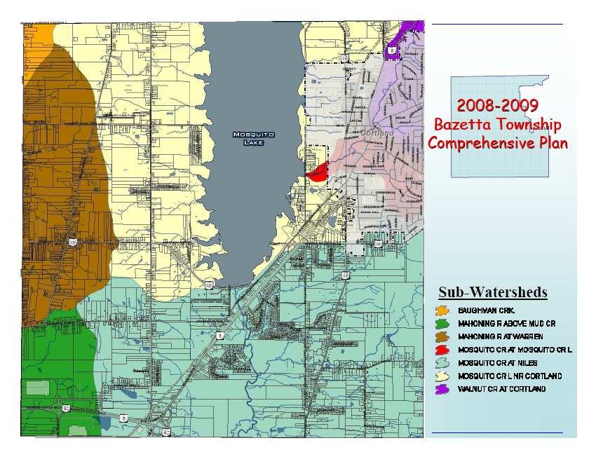
222 Public Input Meetings 214


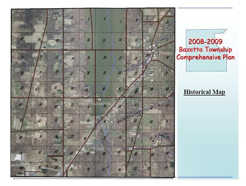
223 Public Input Meetings 215


224 Public Input Meetings 216


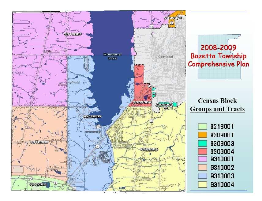
225 Public Input Meetings 217


226 Public Input Meetings 218


227 Public Input Meetings 219


228 Public Input Meetings 220


229 Bazetta Township Comprehensive Plan Existing Landuse Public Input Meetings 221
 Bazetta s Strengths 2008-2009 2009 Bazetta Township")
230 Bazetta Township Comprehensive Plan Existing Zoning The Need for Public Input Public input is critical in the planning process. Please complete the survey s that are distributed tonight SWOT Analysis Checklist Chart Additional Comments = ) Bazetta s Strengths Bazetta Township Comprehensive Plan Public Input Meetings 222
231 = ( Bazetta s Weaknesses Bazetta Township Comprehensive Plan = ) Bazetta s Opportunities Bazetta Township Comprehensive Plan = / Bazetta s Threats Bazetta Township Comprehensive Plan Public Input Meetings 223
232 Questions and Answers Comments? Immediately after completing the aforementioned presentation, Mr. Millea facilitated a discussion with the residents in attendance. The discussion was focused as a SWOT (Strengths, Weaknesses, Opportunities, and Threats) analysis, which allows for an organized and thorough examination of the township. The following information is a summary of the strengths of Bazetta Township as described by the residents. - Excellent snow removal program, the township roads are cleared quickly - Lakeview Local School District is an Excellent rated school system - The township is conveniently located in the county and to major shopping areas - The strong sense of community - Mosquito Lake State Park is located in the township - The township emergency services are excellent - The elected trustees are strong, cooperative, and caring - The township has zoning rules and regulations The following information is a summary of the weaknesses of the township as described by meeting attendees. - There is a lack of water service to many areas, especially commercial properties - Sanitary sewer service is badly needed in many areas - A significant portion of property is not taxable in the township (Mosquito Lake State Park, Trumbull County Fairgrounds, and Warren City Water Department) - The two major attractions to the township, Mosquito Lake State Park and the Trumbull County Fairgrounds, do not provide a direct benefit to the township and many resources such as police and fire are wasted to these areas The following information is a summary of the opportunities of the township as described by meeting attendees. - The presence of Mosquito Lake State Park in the township could be capitalized on - Commercial and industrial development could be increased - The cabins plan proposed by Trumbull County at the state park could become tied into the Western Reserve Greenway bike path Public Input Meetings 224
233 The following item is the only threat mentioned in regard to the township s development. As the meeting was running late, residents were increasingly indicating that they wished for the meeting to be wrapped up. - Crime A significant portion of the meeting was focused on a discussion concerning sanitary sewers. Residents expressed a number of concerns, many of which were addressed by the Planning Commission staff, the township trustees, and Mr. Bill Makosky of Lynn, Kittinger & Noble, Inc. Below is a summary of the questions and concerns voiced at the meeting. - Residents find it difficult to understand how a sewer project works and to receive updates on specific projects. Communication with the Trumbull County Sanitary Engineer s office is difficult. - Several residents expressed their belief that a sewer slated for their area is unnecessary and believed that the explanations and research offered by the Trumbull County Sanitary Engineer s office are faulty. - Technical questions on project scope, procedure, and cost were asked. Residents were referred to contact the Trumbull County Sanitary Engineer s office for more detailed information. - Residents also voiced complaints on the cost of both sewer updates/installations and septic system upgrades. Questions were asked about available funding opportunities. After the discussion had concluded, surveys were collected from the residents, and the meeting was called to a close. Survey Analysis In addition to public comments recorded at the input meeting, surveys were distributed and collected from those in attendance. An example survey is below. Total public attendance at the meeting was 31 residents. Surveys were distributed to all, and 18 were returned partially or completely filled out. In addition to distribution at the public input meeting, surveys were available both as an online submission on the township webpage and in a traditional paper format at the town hall. A deadline for survey submission was set for October 31, Twentythree additional surveys were collected during this time, 12 internet submissions and 11 hard copy submissions. Public Input Meetings 225
234 Public Input Meetings 226
235 Public Input Meetings 227
236 The first section of the survey collected demographic information. The data collected included age range, residency, property and business ownership, work status and location, and household information. According to the tabulated information, all respondents were residents of the township, 90 percent were landowners, and 85 percent were 41 years and older. The average respondent had lived in the township for 24 years and had two adults residing in his or her home. In summary, the typical respondent was a well-established resident living at or near retirement age. The second section of the survey requested that respondents rate township services. The rating levels were superior, adequate, and needs improvement. Services that were rated included utilities, police, fire, EMS, road maintenance, snow removal, streets and sidewalks, parks and recreation, the township website, educational opportunities, and the administration building. The following chart shows the percentage of responses for each service in each rating level. The bold numbers indicate the highest percentage response. Services Rated by Percentage, 2008 (Fig. 74) Service Superior Adequate Needs Improvement Utilities Police Fire EMS/Ambulance Road Maintenance Snow Removal Streets & Sidewalks Parks & Recreation Township Website Educational Opportunities Administration Building The overwhelming trend suggested by this data is that residents mostly agree that the services provided by the township are adequate. The services with the greatest consensus are the administration building and the parks and recreational opportunities in the township. This is unsurprising as the administration building is centrally located and the township boasts a major recreational feature in the state park as well as a quality township park. The services with the highest percentage of complaints are streets and sidewalks and educational opportunities. Again, this is unsurprising as the township lacks sidewalks in nearly all developments and aside from the shared school system of Lakeview, offers no other opportunities for education. The third and final section of the survey asked specific questions of the respondents designed to draw out suggestions, comments, and criticisms in order to gauge public opinion. Respondents were asked the following questions. What do you like most about Bazetta Township? What would you like to see improved in your community? Are there aspects of the Township s infrastructure (services, roads, etc.) that need attention? Would you like to see more public water and sewer lines built? On which roads? Would you be willing to pay for this infrastructure? What are your thoughts on future zoning for the township? Public Input Meetings 228
237 The responses to what residents liked most about the township were widely varied. The most frequent answers centered around the location of the township to important resources such as shopping and services. Another common answer was the country and rural atmosphere. Below is a chart of answers and their frequency, followed by a summary of the longer responses offered by residents. Strengths (Fig. 75) Location, close to shopping and services 12 Country atmosphere/rural 10 Schools 7 Quiet 7 Friendly people 5 Small community/small town feel 4 Laid back community 2 Recreation 2 Bedroom community atmosphere 1 Everything 1 Job 1 Low crime rate 1 Lifestyle 1 Mosquito Lake 1 Privacy 1 Police Department 1 Fire Department 1 Road Department 1 Services 1 - The educational opportunities were the primary reason I moved my family to Bazetta Township. - We like the small town atmosphere and knowing our neighbors and trustees and others who serve us. - It is a nice community to live in and raise children. Good school system - nice people. - A high quality township and the perfect place to retire. - I like the small town feel with a decent amount of people, and the sports activities available for children. - Six generations of my family have been from Bazetta. Roads are named for family. Public Input Meetings 229
238 The responses to what residents felt could be improved in the township also varied widely. Issues and concerns with sanitary sewers were the greatest improvement request of the respondents. This concern was followed closely by requests for water line extensions. Below is a chart of answers and their frequency, followed by a summary of the longer responses offered by residents. Recommended Improvements (Fig. 76) Sewer 9 Water 6 Roads 3 Utilities and aggregation 2 Fire 2 Bicycle trails 1 Detailed information on sewage lines from the Sanitary Engineer s Office 1 Family oriented restaurants 1 Fire service (open both stations) 1 Fix traffic light at 305 and old State Route 5 1 Hiking and nature trails 1 Infrastructure 1 Less taxes 1 Maintenance of zoning lot lines 1 Movie theater 1 Need for a township administrator 1 Need signage to announce meeting dates and times, like other communities 1 No dumpsters 1 No junk cars 1 Nothing 1 Place for kids to hang out, socialize, and be safe 1 Railroad tracks on Bazetta Rd. 1 Senior citizen transportation 1 Sidewalks near Bazetta School 1 Speed regulations enforced 1 Trustee meetings twice a month 1 YMCA or recreational center 1 - City water for the entire township, especially State Route 305 from Bazetta Rd. to North Park Ave. - The trustees need to develop a better marketing plan to convince township residents to support future police/fire/elms/road department levies. Given the current economy, this is critical. - We should merge township with City of Cortland. Eliminate duplication of services i.e. fire, police, etc. Police should be stopping drivers who don't stop at stop signs. Public Input Meetings 230
239 - Not just in Bazetta, but we need a better method to fund our schools and keep them excellent. - Information to residents, the website is rarely updated and lacks good information. - (Fire department) Stop duplication of equipment. Squad cars should not pick up lunch when the stations have full service kitchens. Police vehicles should not be taken home. - Curbside recycling because the drop off location is always full. - Cooperation with police and fire with other communities to lower taxes. - More financial support for schools. - Police Response. To keep this a safe community, police need to respond on every call by getting out of the cruisers and talking to residents. If we have limited ability to solve crimes then we need to be more proactive on preventing crime. - A merger of our Fire/EMS with Cortland. - I would like to see the good old boys network of local government changed, story about trying to have a baseball camp for the community at Bazetta Twp. Park, but being denied for no good reason. More cooperation of the Trustees would be nice. It would be nice if they tried to help and make these things work, rather than just saying no because it is an inconvenience to them. I would also like to see more activities for adults. It would be nice to have some type of recreation center. - I would love to see more bike lanes that lead down to the lake. Maybe on all the major routes that lead to the lake, like State Route 305, and on State Route 46. Or maybe even a trail that goes from Cortland to Howland. I would love to be able take my kids on a bike ride on a path that is less dangerous. It would also be nice to try and get some money coming in by utilizing one of Bazetta s best resources, which is the lake. It would be nice to build something on the lake of a grand size. Something like a huge lodge or something else. - Must the police/ambulance use sirens at night/early a.m. in residential areas? - The idea that Bazetta is the other side of the lake and anyone from Bazetta isn t as good as those on the Cortland side. Public Input Meetings 231
240 Public input on the issues concerning existing infrastructure and opinions on the development of new infrastructure were also solicited. Responses to this question varied widely; however most responses focused on roads, sidewalks, sanitary sewer and water. Below is a chart of answers and their frequency, followed by a summary of the longer responses offered by residents. Recommended Infrastructure Improvements (Fig. 77) Roads 5 Sewer 5 Water 5 Bring fire and EMS back to full force 2 No 2 Railroad crossing on Bazetta Road 2 Congestion around Wal-Mart, additional access points to this location 1 Money management 1 Need one fire station in control of township 1 Sidewalks 1 Some 1 Street lights needed 1 - Railroad crossing on Bazetta Rd. Wal-Mart Traffic has deteriorated it. Road approaching tracks is banked wrong resulting in numerous accidents. - More leaf and branch pick up similar to Howland. - All township residents deserve sewer and water. This would lead to residential/business growth and a greater tax base. - Roadsides were not mowed enough this summer. Just a narrow strip until this fall. - We are one of three houses on McCleary Jacoby without natural gas, if service is brought to an area they should not be permitted to skip. - Post truck load limit sign on Bazetta Rd. - Roads in Timber Creeks older section need repaired. - Howland Wilson Road. - Large tax base for Bazetta seems ignored. - Ditches should be covered. - Knapp Street needs fixed since installation of sewers, currently has dangerous and decaying bumps. - Shrinking demographics affecting services. - More needs to be done for recreation such as improvements in the park s department to include walking and biking trails. - Remove yellow overtaking lane on Route 5 into Timberline Drive, we have contacted state and county authorities before as this is a serious situation. - Add sidewalks to Timber Creek. Beaver Trail is too busy and there are too many pedestrians and children on it to not have sidewalks. - Do traffic study for new signal at Beaver Trail and State Route 5. - The traffic signals by Wal-Mart are not timed the best (mostly due to last light by BP but that s Howland Township I suppose.) Public Input Meetings 232
241 - Acknowledge that Miller Yount development has sewers, they work, and we don t want our street torn up, we fought to get it paved, because of an argument years ago. As sanitary sewer and water lines were anticipated to be hot spots of concern for residents, several questions on the survey specifically addressed this topic. Residents were first asked if they would like to see more sanitary sewer and water services in the township. If they answered in the affirmative, they were then asked to suggest locations for construction, and whether they would be willing to pay for such services. Twenty-six respondents indicated a desire for construction of sanitary sewer or water or both services. Sixteen respondents mentioned a specific location where these services are needed. Seven residents indicated they would be willing to pay for such services. Four indicated they would need to consider the cost involved. Two residents indicated that they would not be willing to pay for the cost of such services to be provided to other residents. Eight residents responded that they do not wish for these services to be expanded in the township. Below is a chart of the specific areas mentioned by residents in which they would like to see sanitary sewer, water, or both services extended. Sanitary Sewer and Water Line Recommendations (Fig. 78) All Roads 3 Andrews Drive 2 Cadwallader Sonk 2 Durst Clagg 2 Bazetta Road 1 Bazetta Road 1 Bazetta Road to State Route McCleary Jacoby 1 North Park Ave. 1 State Route State Route 305 from Bazetta Road to North Park Avenue 1 State Route 305 from State Route 46 to Southdale 1 State Route 46 1 State Route 46 south of State Route Finally, residents were asked opinions on zoning. As zoning is designed to protect the integrity of the township and guide growth in a proper and planned manner, it is critical to consider the opinion of those who the zoning regulations serve. Thoughts on zoning were diverse and are summarized below. - Keep upgrading - Needs updating restriction - Need more zoning - Need more information - Discuss options publicly - Have them come to a township meeting - Get rid of the garbage can on Lynn Ave. - Respect current residential areas Public Input Meetings 233
242 - Stricter zoning - The entire zoning commission is out of touch with reality. They all need to be replaced. They are the biggest determent to the progress of our township. - Enforce the rules currently on the books - A firm code - The zoning is good, keep it mostly residential with light commercial and small business - Make it to protect property values - Enforcing zoning and land improvements and require fine payments for parked cars, junk, and tires - New developers should use curbs and street lights - Planned growth with community involvement - Necessary for planned development - No trailer parks. Allow business development in areas already designated commercial or designate new areas only where residential development isn t appropriate or possible. No heavy industry because we are too close to the lake. - Current is adequate - I hope that Bazetta Township would be flexible in its zoning regulations and help keep eye sores such as junk yards limited to non-high traffic areas - I think that is the current economy people should be allowed to have more control over property they are struggling to pay for - The less zoning and bureaucracy the better - Is there a fight between the Zoning Commission and the Trustees? Reading the township minutes makes me wonder why there is a zoning commission. Public Input Meetings 234
243 Summary Most residents who responded to the survey feel pride in the rural atmosphere of Bazetta Township. These residents also seem pleased with the convenient location of the township in the county. Especially with State Route 82 located in the southern portion of the township, most residents are 15 minutes away from professional offices in downtown Warren and retail and entertainment options in Niles. Additionally, residents enjoy the recreational activities offered by the state park and the township park. Residents felt concerned with several major issues in the township. Among the most discussed and expressed is the issue of sanitary sewers. Costly and important to existing and future development, the issues surrounding sewers is by far and large the most significant concern of township residents. Other concerns of the residents included infrastructure issues such as water lines and roads and management of township resources like the fire department. Public Input Meetings 235
244


245 E-Government Bazetta Township publishes and maintains a website for public use. The url address is The website currently has information on the fire department, police department, road department, administration, zoning department, trustee notes, the township park, community news, meeting agendas, and zoning rules. The site also maintains links to information on recycling and streetlight out problems. Because many local governments are beginning to utilize the internet as an important method of communication with the population, this section will review the current internet resources Bazetta Township has in place and briefly discuss future objectives the township has for its website. Screen shots taken on 4/08/08 The following is a listing of the information tabs provided on the township website and a brief summary of each. Administration - includes a brief note from the township fiscal officer as well as the listing of the current trustee administration. Community News currently lists the information for the Niles-Trumbull Transit System. The page is designed for announcements in the township. Fire Department this links to a skeleton of a webpage for the fire department. Currently no active information is posted on this page. E-Government 237
246 Meeting Agenda announces the next trustees meeting date and time. The agenda for said meetings is posted in the days immediately preceding the meeting. Otherwise the page contains the minutes to the last trustees meeting. These minutes are a summary of the meeting; the page alerts the viewer that the in depth meeting minutes are available at the administration offices. Police Department links to the township police department s website. Although the site still has several pages under construction, there is still a significant amount of information available. The site lists the current officers, information on starting block watch groups, the department policies page, a PowerPoint presentation for recruitment, and links to other pertinent information such as crash data and sex offenders. Recycling this is an external link to the Geauga-Trumbull Solid Waste Management District website. Road Department lists the supervisors name and a brief description of the department and related responsibilities. The page also lists an hour s summary of all duties performed in the previous month. Street Light Out this is an outside link to First Energy s Report Streetlight Outage webpage. Township Park lists the closing/opening date of the park and a recently added park rule. No description is included although four pictures are posted of the park. Trustee Notes - lists reminders and updates for the township. Information such as the status of projects (sewers, streetlights, etc.) and reminder information on meeting times and the recycling program are found here. Zoning - lists the current zoning inspector and a description of the zoning department as well as upcoming meeting information. The link also lists the minutes to the last zoning department meeting. According to the site, the zoning resolutions are available in print form or CD-ROM format for a small fee. Zoning Rules - links to an online copy of the zoning resolution manual. The main page also listed major announcements and reminders for the township, the address, phone number, and hours of operation for the township administration office. All notices are posted on the town hall doors and the website. This is important as it indicates that the township is accommodating to both traditional and modern forms of communication. While keeping up to date with technology is important, it is equally important to allow equal access to information to all residents. The more traditional methods of communication are accessible to those that do not have internet access readily available or for those that prefer to not use the internet. Bazetta Township maintains the website in house and does not currently contract out services for this tool. The website has been functionally running for approximately two years. The township is aware of how vital a tool the internet can be and strives to make all information easily accessible for residents. The township trustees have committed themselves to ensuring the webpage is updated as frequently as possible and will continue to consider adding more material to the site. One public document in particular, the Administrative Policy Manual, is currently being considered for addition to the site. E-Government 238
247 Plan of Development
248
249 Sanitary Sewer and Water Facilities Element The provision of water and sanitary sewer facilities to an area plays an important role in the health and safety of residents and the potential for new development. As an unincorporated area, Bazetta Township is unable to provide these services to its residents and businesses, many of which still rely on water wells and septic tanks. However, local municipalities and the county are able to provide these services. Currently the county provides these services to portions of the township. In order to provide water service, it is necessary to have an adequate water supply, a water purification facility and the means to transmit the treated water through pipes to customers. For a sanitary sewer system, it is necessary to have a waste water treatment plant on an adequate receiving stream and sewers that carry waste water to the facility by gravity or force (pump stations). The potential to serve areas of Bazetta Township with sanitary sewer and water facilities depends on several factors, including where the area is located, its proximity to existing facilities, topography or other environmental features, the estimated costs and sources of funding that are available. For sanitary sewer service, areas are designated by the regional Water Quality Management Plan to be served by particular waste water treatment plants based on watersheds and topography. This allows for proper planning for the size and capacity of waste water plants, and the local collection system, including gravity flow sewers, force mains and pump stations. Many parts of the township are served by water lines or have the potential to be served by water lines. Trumbull County maintains and constructs the water pipes and supplies the water used within the Champion Water District located in the western half of the township and the Howland Water District in the southeastern quadrant of the township. Since Trumbull County does not have direct ownership of a water supply, water must be purchased from a provider. This water is purchased from the City of Warren with Mosquito Lake as the source. The south central area of the township is served directly by the City of Warren, and portions of the township nearest the City of Cortland are served via the city s extensive system of wells. The following narrative describes how sanitary sewer and water service can be provided to specific areas of the township that are not currently served by these facilities. Based on identified needs, costs, availability of funding and other factors, priorities have been established on a countywide basis for the construction of these facilities. These priorities and accompanying research can be found in the Trumbull County Blueprint for Sewers Plan. Realistically, even with this plan for new construction and obtaining funding, not all parts of the township will be served by sewer and water in the future. Sanitary Sewers Due to the nature and costs of sanitary sewer systems, it is likely that the eventual service area for sewers in the township will be smaller than for water service. The waste water in sanitary sewers either flows downhill by gravity or it is pumped by expensive pump stations and force mains. Also, any sewer line must be linked to specific waste water treatment systems with sufficient treatment capacities and other issues, including separating combined stormwater and sanitary sewers. Significantly more areas of the township have access to water than those with Sanitary Sewer and Water Facilities Element 241
250 access to sanitary sewers. Despite the cost, the availability of sanitary sewers is important for the township s future because improper treatment of residential or commercial waste water can cause pollution and related health and safety hazards. While some new development can occur through the installation of individual septic tanks, the extension of sanitary sewer lines is often necessary for any higher-density residential uses or more intensive commercial or industrial development. In Bazetta Township, the highest priority for the extension of sanitary sewer lines should be those areas with failing septic systems, where sanitary sewers are close enough to be feasibly extended. Within the township, three consent decree sanitary sewer projects are in various stages of completion. The project closest to completion is Northview Road. The second nearest to completion is the East Central Bazetta/McCleary Jacoby/SR 305 sewer project. This project, one of the consent decree areas, was mostly completed in the summer of 2008, and residents have been tying in. The Lakeshore Drive project was the last of the three to start, and is currently under construction. As a consent decree area, the project must be completed by December 31, 2010, per the agreement between OEPA and the Trumbull County Health Department. In obtaining the necessary funding for these multi-million dollar projects, the county has tried to leverage funds available from local, state and federal sources, including grants and loans. Where the problems occur in low- and moderate-income neighborhoods, the county has been able to obtain funding from the Community Development Block Grant (CDBG) program to help leverage other funding sources. In fact, the highest priorities of the county s CDBG Program are to help address the health and safety needs of low- and moderate-income investment areas. Although on the list of state mandated unsewered areas of concern, Bazetta Township s three consent decree areas are not considered to be low- or moderate-income and therefore are not eligible for such grants. In addition to the consent decree areas, three petition projects were in progress. Two petition projects were pending, one for the Cadwallader Sonk neighborhood and one for the Westview Drive neighborhood. For the third project, at Janet, Lynn and Andrews Drives a public hearing was held and residents approved the project. The petition process is an important option for neighborhoods who wish to make the upgrade from Home Sewage Treatment Systems, and the following flow chart illustrates this process. Sanitary Sewer and Water Facilities Element 242

251 (Fig. 79) Sanitary Sewer and Water Facilities Element 243
252 Outside of these projects, little new sanitary sewer construction is planned for the near future. As dictated by the Trumbull County Blueprint for Sewers Plan, the ideal situation would be to have sewers constructed throughout much of the township within 20 years; however, cost and time constraints, make this highly unlikely to happen. The following map from the Blueprint Plan illustrates these ideal locations, as well as the current status of the existing projects in the township. Sanitary Sewer and Water Facilities Element 244
253 Water Currently, there are many more water lines serving the township than sanitary sewer lines as a result of historical events, costs, political considerations, and availability of funding. The township is primarily served by three water systems, except for a tiny portion of State Route 46. Water supplied through the Champion Water District and the Howland Water District, by way of the Trumbull County Sanitary Engineer s Office, serves the eastern half and extreme south central area of the township respectively. Warren City services State Route 5, Timber Creek, Ivy Hills, and the Perkins Jones area. Cortland City s well system services many households in the northeast quadrant of the township New water service in the eastern areas of the township would most likely be provided by Trumbull County through an extension of water lines. Durst Clagg Road, State Route 305, Everett Hull, and Geauga Portage Easterly are examples of such areas. In the southeastern areas of the township, State Route 46, Henn Hyde, Howland Wilson and McCleary Jacoby could easily be served by extensions from Warren City, Howland Water District (Trumbull County) and in some areas Cortland City s well system. Despite the ultimate goal to supply public water service to all areas of the township, the estimated cost of extending new water lines is prohibitive. Therefore, the highest priorities should be for more urbanized areas of the township. If any areas in particular were to begin to experience well water problems (with either quantity or quality of well water) they would also become a priority. Currently there is only one water line project in the township: Westview, located off south State Route 46 has an open petition project. Residents can pursue a petition water project if they are interested in the construction of water lines. This process is identical to the previously noted petition process for sanitary sewers. The Bazetta Township Trustees actively encourage residents to pursue this process if they are interested. Sanitary Sewer and Water Facilities Element 245

254 Sanitary Sewer and Water Facilities Element 246
255 Community Facilities Element Community facilities primarily concerns those owned and operated by the local government. The township currently owns and operates the property and buildings on and in which two fire stations, the police department, road department, township park, and township administration building function. With the exceptions of the fire stations, all township buildings and properties are ideally situated in the central area of the township. When considering future community facilities, it is imperative to review the major variables involved. Perhaps the single most influential variable is the availability of funding. Without adequate funding, most proposals cannot be started or completed. As funding must generally come in the form of tax revenues, sufficient need must be shown to the township residents. Another variable is the level of urgency concerning the need. The proposed project might be something that is more of an ideal rather than a necessity or even an emergency. These two variables are not unrelated. A need that is extremely urgent is much more likely to be placed on the ballot and passed versus a want that is not necessary during tough economic times. On the other hand, a need may become urgent because it has been deferred over time, with an associated increase in cost. Because of these issues, it is important to review both short-term and long-term solutions to identified deficiencies. In many cases, a solution might not currently be available due to lack of funding; however, it is still imperative that the need is identified. Fire Department Before nearly any future considerations, recommendations, or plans can be implemented, the department must achieve a fiscal balance. The chief strived to balance the budget in 2009, and hoped to carry a balance into The passage of a fire levy on a recent ballot will greatly aid in the achievement of this goal. Upon the success of a balanced budget, the fire chief has several goals he will strive to achieve. In the short term, the township would like to upgrade the EMS Units currently in use. This would ideally consist of retiring two older ambulances and purchasing one newer unit. Two major factors influencing the fire department are location and budgetary issues. In terms of location, one centrally located fire station would make a greater impact on safety rather than operating two stations on alternating days on opposite ends of the township. A new central location would need to be very near the major roads in the township, State Routes 305 and 5. Consolidation plans have been considered in the past, but have not come to fruition. Locations previously considered include the intersection of Elm Road/State Route 5 and Hoagland Blackstub Road, and State Route 5 between State Route 305 and Mosquito Creek. An undertaking of this magnitude would demand significant financial resources to secure a proper location and construct a new station. The precarious fire department budget should benefit long term from such an undertaking. A central location would drastically reduce general utility bills and consolidate equipment. Savings from reducing duplicate equipment ranges from the cost of a copy machine and supplies to fire engines and ambulances. Another sweeping proposal that would aid in this process would be to merge Bazetta Township s Fire Department with the City of Cortland Fire Department. Ideally Community Facilities Element n 247
256 this would provide savings in major equipment; for example, each department currently has a ladder truck, one could serve both communities, and in administrative costs. Police Department The Bazetta Township chief of police found no major concerns with the ability of his department to serve the township in the future. Location, equipment, and resources are adequate to continue adequate service. The single high priority issue is future funding. Recent commercial and industrial downsizing, the increasing rate of delinquent property taxes, and pending changes in Ohio tax law, all indicate a continuing loss of revenue for local governments. A major focus for the future will be securing revenue to properly run the police department and other emergency services. The chief has already taken a critical first step in this process by ensuring that the department runs at or below budget each year. Road Department Bearing in mind the financial constraints of the local economy, the Road Superintendent felt that the department is fully able to function with available resources. Again, with an unpredictable fiscal future in mind, recommendations are based upon availability of funds. The township will need a snowplow truck to replace the 1988 model currently in use. Since the truck is now over 20 years old, a new truck will be budgeted for in the near future. Additionally, the road department will likely consider the purchase of a pickup truck in the future for plowing intersections and smaller areas that a large snowplow truck cannot efficiently or effectively cover. As with any department, any major increases in funding would immediately beg consideration of staff resources and later construction or addition of additional office and work space. Community Facilities Element n 248
257 Environmental Element Environmental Conclusions Wetlands perform critical functions and provide many benefits, including food and habitat for fish and wildlife; flood protection; erosion control; natural products for human use; water quality improvement; and opportunities for recreation, education, and research. The costs of losing the functions this critical resource provides far outweigh any alternative use. Floodplains are integral to watersheds and river systems. Alteration or development of floodplains eliminates or degrades their vital functions and can present a safety issue. Floodplains are like nature s giant sponges, soaking up excess water during storms that would otherwise flow with such intensity that anything downstream in its path could be washed out. If those areas are altered or filled, it would only be a matter of time before flood water destroys any man-made structures in them. If the floodplains are destroyed or impaired, even smaller storm events could be catastrophic. By planning wisely and affording protection to floodplains, communities can balance economic growth and suburbanization with the protection of natural resources. We can protect a floodplain's functions and processes to create and maintain a better quality of life and living environment for the future generations that will work and live here. A forested stream buffer zone (the land-water transition zone with trees and natural vegetation) along rivers, creeks, and tributaries can provide vital protection at relatively little to no cost to the public. Streams and adjacent streamside forests and riparian buffer areas form the most vital and diverse feature of our landscape. Mature trees are like giant straws, taking hundreds of gallons of water up in through their roots and storing it in their trunks. The roots also hold the soils together and prevent erosion. Without trees in this land-water transition zone, streams typically become wide and shallow, habitat is degraded, and water quality drops. The streamside forest removes pollutants from storm water runoff, removes pollutants from the water during periods of over-bank flow, reduces water temperatures by sheltering and shading, provides wildlife habitat, protects and creates aquatic habitat, provides detritus (leaves and woody debris), which is the basic source of energy for the stream ecosystem, and reduces streambank erosion through the high durability of tree root mass. It can be concluded that the protection of wetlands, floodplains, and mature streamside forests is the most economical/cost effective solution available to the planning area to reduce storm water runoff, flooding and increase water quality and safety of downstream residents. Environmental Plan 249
258 Environmental Recommendations The township should strive for ecologically sustainable development, which is the human use of natural and cultural resources that meets the needs of society today, while conserving our resources and ecosystems for the benefit of future generations. Due to higher costs associated with developing on steeper slopes, for water quality protection and safety hazards associated with building in such areas, the township should avoid any development on steep slopes, especially along drainage ways. These areas should instead be covered with native vegetation. The township should avoid or otherwise protect wetlands and hydric soils from any destructive activities and should adopt a Wetland Setback Protection Resolution. Because of direct and indirect safety hazards associated with building in flood hazard areas, and because of water quality issues, the township should protect the floodplains and avoid any development along drainage ways that eliminates or degrades these vital values and resources. It is further recommended that the township incorporate a floodplain overlay district into its Zoning Resolution and adopt a floodplain setback resolution. Land-water transition zones or riparian buffer zones with trees and natural vegetation should remain intact and protected, or they should be restored to their natural states of forested vegetation for inexpensive and vital protection of our waterways. To that end, the township should adopt a streamside forest buffer protection resolution. The township should use natural, non-structural systems to retain/reduce the flow and intensity of storm water runoff. Properly designed retention basins capture storm water and do not contribute extra water to our streams and floodplains. Environmental Plan 250
259 Green Element In an era where it is increasingly important for communities to pay attention to volatile costs and supplies of fuel as well as to environmental degradation, it is critical that a plan for environmentally healthy development is devised. Building greener offers a wide array of benefits for developers, investors, residents, and the environment, which can lead to healthier homes and communities, lower energy and water costs and a protected environment. Housing conditions are important factors influencing health. Green design and building practices can create healthier home environments through better indoor air quality and healthier building materials. New and remodeled buildings are better performing, cutting utility costs for owners, residents, and building managers. How and where we build has a huge environmental impact. Buildings account for 38% of annual carbon dioxide emissions, 30% of both raw materials waste and landfill waste, and 12% of potable water consumption. Environmentally responsible site planning and development, along with energy- and water-efficient buildings can make a positive contribution to the environment. Taking this into consideration, it is critical that other methods for creating a green community should be regarded. Although the Trumbull Mahoning Green Pact has excellent energy efficiency and pollution reduction goals that the township can strive for, it is important to connect specific goals to cost savings and an implementation schedule. The following is a recommended schedule of policies and procedure changes that the township can choose to implement. This strategy is loosely adapted from the City of Charleston: Green Initiatives, October 30, Recommendations for immediate consideration by the township are simple and relatively low cost, if not free, to implement. The list of future recommendations would be more costly and would require an adequate budget and time to implement. Those suggestions are not concrete, but can help guide future energy and environmentally smart decisions for the township. Ongoing Initiatives by Bazetta Township Recycling is currently available in the township at a designated drop off location in front of the road department facility on State Route 305. The Geauga-Trumbull Waste Management District provides a plastic/metal mixed-use drop off dumpster and a paper dumpster for recycling as a part of a contact agreement with the township. Green Element 251

260 Mixed Use and Paper Recyclables Accepted at the Drop off Site in Bazetta Township Initiatives for Immediate Consideration Sign the Trumbull Mahoning Green Pact (document located at end of section). rather than print documents whenever possible. Promote green awareness in the community via programs or exhibits; these could be held at the township hall or in other local communities and posted on the township website. Post environmentally friendly tips for residents on the township website. An example follows this list of initiatives. Recycle office paper, ink cartridges, and other supplies. This can be easily done by placing bins in township buildings and staff can drop off at the centrally positioned recycling dumpsters. Turn lights off when not being used. Encourage proper tire pressure on township vehicles to conserve fuel. Discourage engine idling also to conserve fuel. Replace burned out light bulbs with LED energy efficient lighting. Turn off computers and printers at the end of the day. Print on both sides of the paper whenever possible. Reuse paper for scratch sheets. Use reusable containers for water, coffee and other refreshments. Adopt zoning standards for open space protection, stormwater run-off reduction and landscaping buffers. Using natural light during the day wherever and whenever possible. Lower the thermostat in the winter and raising the temperature on air conditioning in the summer by a few degrees. Unplug appliances that are not in use. Add plants to the office to aid in cleaning the air. Bring lunches to work or eat in local restaurants, reducing time driving home for lunch. Green Element 252
261 Examples of Green Tips from the 2007 Trumbull County Popular Annual Financial Report Green Element 253

262 Green Element 254
263 Initiatives for Future Consideration New vehicles purchased should have better gas mileage. Rehabilitation of existing buildings should use green, environmentally friendly materials such as bamboo flooring, recycled composite materials, low volatile organic compound (VOC) paint, and energy efficient windows wherever possible. Construction of existing buildings should use green, environmentally friendly materials such as bamboo flooring, recycled composite materials, low VOC paint, and energy efficient windows wherever possible. Rehabilitation of existing structures should be encouraged over demolishing and reconstructing a new structure. Review every five years the cost of solar panel or other like renewable energy installation for economic feasibility. Green Element 255

264 Green Element 256

265 Green Element 257
266
267 Future Land Use Element Based on a review of the inventory data collected, the information received from the public meeting and consultations between the Bazetta Township Trustees and the Trumbull County Planning Commission staff, a proposal for the future use of land in the township was prepared. Inventory information that was vital to this review included existing land use, environmental characteristics, zoning and the availability of public infrastructure. The township trustees and Planning Commission staff considered these capabilities and limitations in relationship to past trends, current conditions and proposals for the future. The analysis and planning process resulted in proposals on guiding future land development and protection of existing land uses. The Future Land Use Plan should serve as a guide for growth and change in the township. The Future Land Use Plan for Bazetta Township addresses four major issues: the location, manner and type of future commercial development; optimal location of industrial development; locations in which to encourage residential growth; and the general development policy concerning open spaces, existing farmland and environmentally sensitive areas. Each issue is critical in the growth and development of the township, and as such, is given their due consideration. Future land use will also be summarized by neighborhood. Commercial Development Because of Bazetta s prime location in relation to Warren City and Howland Township and the movement of commercial activity northward from those areas, the township is expected to feel commercial development pressures. In particular, pressure is occurring and is anticipated to continue along State Routes 5 and 46. Additionally, the growth of Cortland in the northeast section of the township is driving development south along State Routes 5 and 46. Bazetta Township is in an excellent position to properly consider what this future development should look like and plan accordingly. The township s most significant commercial corridor is State Route 5. Historically the most significant route connecting the City of Warren and the Village of Cortland, this road has remained highly traveled since its construction. Currently commercial development is heaviest along the Howland Township border. The largest and most significant development in the township is located along Millennium Boulevard where a Wal-Mart Super Center was constructed. As with most large commercial retail stores, and especially with Wal-Mart stores, further retail development is often attracted to the area. A newly-constructed shopping center located immediately off State Route 5 and available open land for new construction affords prospective businesses several options for opening in this area. Larger, heavier commercial uses are best suited in this area, particularly in the building previously used by Wal-Mart. Traveling north on State Route 5, the landscape becomes increasingly more residential. Future commercial development along the road should decrease in intensity traveling northward, eventually becoming small retail shops and commercial office professional facilities near the City of Cortland. Development is naturally limited on the west side of State Route 5 by a rail line that runs parallel to the roadway. Any new construction would need to be very small in scope on Future Land Use Element 259
268 the west side of State Route 5. Slightly larger construction may occur on the east side of the roadway. State Route 46 is the second area in the township where significant commercial development could occur. Dramatically less developed than State Route 5, State Route 46 was beginning to experience pressure from Cortland in the north and Howland Township in the south. As with the northern portion of State Route 5, development along this road should be smaller, concentrated commercial developments. Commercial office professional and small retail shops would be best suited to this relatively residential area. Additional locations for future commercial development throughout the remainder of the township will likely be restricted due to limited access to sanitary sewers. The most obvious location for additional commercial development should sewers be constructed is at the Perkins Jones and State Route 82 interchange. The Delphi building, Kmart Distribution Center and Autumn Industries lend to the area a light industrial presence, which some commercial development could thrive near; however, it is unlikely that sewers will be constructed in that corridor in the near future. Industrial Development Existing industrial development is scattered along State Route 5 and is localized on Perkins Jones Road and at the State Route 82/Larchmont interchange. As the township encourages commercial growth along State Route 82, further industrial development in this area should be limited to existing industrial businesses. The ideal location in the township for future industrial growth is in the far southwest corner of the township. The southwest corner of the township is appropriate for future industrial development for several reasons. The area already boasts a small center of industrial development, as a portion of the Delphi complex is located there in addition to Autumn Industries and the K-Mart Distribution Center. An interchange with State Route 82 is also located in this area. State Route 82 is a limited access highway that connects to several significant transportation routes including State Route 11 and Interstate 80. The Youngstown Warren Regional Airport is also located just off State Route 82 on State Route 193 in Vienna Township, less than a 20-minute drive away. Additionally, rail access would be possible with some expansion and reconstruction of existing track located east of the K-Mart Distribution Center. Residential land uses in this area are minimal. Despite this ideal location for a small industrial center, a critical hindrance to future development is that the area lacks sanitary sewers. The nearest existing sewer line is a private extension that serves the Delphi complex. The cost of extending this line or a line located nearby in Warren Township would be significant. Funding for such a project could potentially be found via grants through the US Economic Development Administration, Community Development Block Grants, Tax Increment Financing, the Ohio Department of Development s (ODOD) Office of Tax Incentives, an ODOD 629 Grant, and/or the US Department of Agriculture s Rural Development Program. Job creation and local matching funds are often a requirement in most Future Land Use Element 260
269 grant programs. Sewer lines could be extended as part of a private petition project; however, this method would likely be costly. Residential Development Bazetta Township boasts several significant residential housing developments including Timber Creek and Ivy Hills. Most of the residential development in the township has occurred in the south, primarily due to the lack of sanitary sewers in the northwest area of the township and the vast amount of space occupied by Mosquito Lake and the City of Cortland in the north-central and north-eastern portions in the township. Future development in those areas will be limited for the same reasons. Additional single-family residential growth in the township should primarily occur in the southeast quadrant of the township where several well-established housing developments are located and plenty of open space is available for expansion. Water and sanitary sewer service are readily available to most of these areas, making the land prime for future residential uses. East of Mosquito Creek and into the southwest quadrant of the township are the bulk of the township s multi-family residential developments. Ivy Hills is the most defined and contains a number of multi-family apartment complexes as well as two-, three- and four-unit townhouses and condominiums. Additionally, several large apartment buildings are located along Perkins Jones Road. These areas are ideally suited to future multi-family housing due to ready access to State Routes 5 and 82, sanitary sewer and water facilities. Open Space and Farmland Preservation The Future Land Use Plan for the township strongly encourages the preservation of open spaces and natural areas in places not otherwise identified as having some development potential. Once developed, it is nearly impossible to return land to its natural state. In Bazetta Township there are three types of areas that should be preserved: farmland, environmentally sensitive areas such as flood plains or wetlands and other open space areas where water, sewer or transportation facilities are not available to support new development. Beyond the limits of existing and proposed development, these areas should be preserved because of their ecological functions. Many residents stressed that they preferred the township retain its rural, small community setting. Protection of natural areas is an ideal way to address these desires. The primary location for open space and farmland preservation in the township is in the northwest quadrant. As this area lacks sanitary sewer and water lines, it is the least ideal candidate for residential, commercial or industrial development. Since there are other more appropriate locations in the township for development, this area should retain its rural nature. Development should also be avoided in environmentally sensitive locations. As indicated on the Wetland and Hydric Soils and the Special Flood Hazards maps located in the Environmental and Physical Characteristics section of the Inventory, any development in these locations should be limited. Any development that must occur should carefully investigate and research the land in question prior to construction. Future Land Use Element 261
270 Several areas of the township are currently protected by local, state or federal agencies or are in the process of becoming protected. Development will naturally be prevented surrounding Mosquito Lake, as nearly all of this property is owned and protected by the United States Army Corp of Engineers. Similarly, development along the Mosquito Creek Corridor is systematically being protected through the acquisition of the most environmentally sensitive lands in this area. Several pieces of property have been purchased with Clean Ohio funding or were donated by individuals and subsequently given to the Trumbull County MetroParks to be protected from development and held as nature preserves or as passive recreation parks. Future Land Use Element 262

271 Future Land Use Element 263
2014 Plan of Conservation and Development
 The Town of Hebron Section 1 2014 Plan of Conservation and Development Community Profile Introduction (Final: 8/29/13) The Community Profile section of the Plan of Conservation and Development is intended
Existing Land Use. Typical densities for single-family detached residential development in Cumberland County: 1
 Existing Land Use A description of existing land use in Cumberland County is fundamental to understanding the character of the County and its development related issues. Economic factors, development trends,
Land Use. Land Use Categories. Chart 5.1. Nepeuskun Existing Land Use Inventory. Overview
 Land Use State Comprehensive Planning Requirements for this Chapter A compilation of objectives, policies, goals, maps and programs to guide the future development and redevelopment of public and private
PURPOSE OF STUDY. physical and social environments, as well as our political and economic institutions. As a commodity,
 PURPOSE OF STUDY Housing is one of the most important elements in our lives and our communities. Providing shelter and links to neighborhoods and larger communities, housing plays an essential part in
Addressing the Impact of Housing for Virginia s Economy
 Addressing the Impact of Housing for Virginia s Economy A REPORT FOR VIRGINIA S HOUSING POLICY ADVISORY COUNCIL NOVEMBER 2017 Appendix Report 2: Housing the Commonwealth's Future Workforce 2014-2024 Jeannette
LAND USE Inventory and Analysis
 LAND USE Inventory and Analysis The land use section is one of the most important components of the comprehensive plan as it identifies the location and amount of land available and suitable for particular
2014 Plan of Conservation and Development. Development Plan & Policies
 The Town of Hebron Section 3 2014 Plan of Conservation and Development Development Plan & Policies C. Residential Districts I. Residential Land Analysis This section of the plan uses the land use and vacant
HS / MS Bus # by Street Updated Numbers 35 Adams Ct Amy Pl Andrews Dr Anthony Cir Argali Pl
 Updated 8-15-18 Numbers 35 Adams Ct 50-140 9 Amy Pl 17-52 21 Andrews Dr 2351-2501 11 Anthony Cir 23-44 32 Argali Pl 100-149 11 Aspen Pl 100-119 3 Bank St - N 12 Bank St - S 12 Bayberry Ave 265-295 33 Bazetta
PLANNING FOR OUR FUTURE
 PLANNING FOR OUR FUTURE ELLSWORTH TOWNSHIP LAND USE AND POLICY PLAN The purpose of this Plan is to serve as a guide for the Township Trustees, Zoning Commission, Board of Zoning Appeals, developers, employers,
410 Land Use Trends Comprehensive Plan Section 410
 411 410 Comprehensive Plan Section 410 In order to plan future land use, we must know how the land is used today. This section includes the following: Definition of analyzed land-use categories Summary
Housing Characteristics
 CHAPTER 7 HOUSING The housing component of the comprehensive plan is intended to provide an analysis of housing conditions and need. This component contains a discussion of McCall s 1990 housing inventory
HUMAN ACTIVITY IV. RESIDENTIAL PATTERN AND HOUSING RESIDENTIAL PATTERN
 HUMAN ACTIVITY IV. RESIDENTIAL PATTERN AND HOUSING RESIDENTIAL PATTERN Mount Holly sits astride the Green Mountain ridge, land formally glaciated and presently covered primarily with glacial till soils
Appendix A. Factors Affecting City Current Expenditures
 Appendix A Factors Affecting City Current Expenditures Factors Affecting City Current Expenditures Every city faces a unique situation based upon its demographic composition, location, tax base, and many
Housing Element Amendment. Borough of High Bridge
 Housing Element Amendment Borough of High Bridge Hunterdon County New Jersey September, 2004 Prepared for: The Borough of High Bridge 71 Main Street High Bridge, N.J. 08829 Prepared by: Art Bernard, P.P.
Appendix D HOUSING WORK GROUP REPORT JULY 10, 2002
 Appendix D HOUSING WORK GROUP REPORT JULY 10, 2002 Work Group Assignment At the 20/20 forum in April 2001, the community expressed a need for housing policies which will protect both the Town s social
5. PROPERTY VALUES. In this section, we focus on the economic impact that AMDimpaired
 5. PROPERTY VALUES In this section, we focus on the economic impact that AMDimpaired streams have on residential property prices. AMD lends itself particularly well to property value analysis because its
CHAPTER 2 VACANT AND REDEVELOPABLE LAND INVENTORY
 CHAPTER 2 VACANT AND REDEVELOPABLE LAND INVENTORY CHAPTER 2: VACANT AND REDEVELOPABLE LAND INVENTORY INTRODUCTION One of the initial tasks of the Regional Land Use Study was to evaluate whether there is
CASS COUNTY MASTER PLAN July 1, Appendix C LAND USE
 Appendix C LAND USE Introduction Existing land use and development patterns in Cass County are important considerations in the development of policies addressing future growth and land use. Existing land
REGIONAL. Rental Housing in San Joaquin County
 Lodi 12 EBERHARDT SCHOOL OF BUSINESS Business Forecasting Center in partnership with San Joaquin Council of Governments 99 26 5 205 Tracy 4 Lathrop Stockton 120 Manteca Ripon Escalon REGIONAL analyst april
Nonresidential construction activity in the Twin Cities region was robust in 2013
 1 Recent Nonresidential Construction Activity in the Twin Cities Region March 2015 Key Findings After bottoming out in 2010, nonresidential construction activity in the Twin Cities region is once again
Linkages Between Chinese and Indian Economies and American Real Estate Markets
 Linkages Between Chinese and Indian Economies and American Real Estate Markets Like everything else, the real estate market is affected by global forces. ANTHONY DOWNS IN THE 2004 presidential campaign,
City of Lonsdale Section Table of Contents
 City of Lonsdale City of Lonsdale Section Table of Contents Page Introduction Demographic Data Overview Population Estimates and Trends Population Projections Population by Age Household Estimates and
L. LAND USE. Page L-1
 L. LAND USE 1. Purpose This section discusses current and likely future land use patterns in Orland. An understanding of land use trends is very important in determining Orland's ability to absorb future
4 June 11, 2014 Public Hearing
 4 June 11, 2014 Public Hearing APPLICANT: FRANKLIN JOHNSTON MANAGEMENT DEVELOPMENT, L.L.C. PROPERTY OWNER: TRUSTEES OF FIRST LYNNHAVEN BAPTIST CHURCH STAFF PLANNER: Stephen J. White REQUEST: Change of
Multifamily Market Commentary December 2015 Single-Family Rental Sector Attracting Institutional Investment
 Multifamily Market Commentary December 2015 Single-Family Rental Sector Attracting Institutional Investment Prior to the Great Recession, the cratering of single-family home prices, and declines in the
Comprehensive Plan /24/01
 IV The is a central component of the Comprehensive Plan. It is an extension of the general goals and policies of the community, as well as a reflection of previous development decisions and the physical
19.12 CLUSTER RESIDENTIAL DISTRICT
 Chapter 19.12 CLUSTER RESIDENTIAL DISTRICT (Adopted 12/22/2003; Ordinance #0061970). Amended 7/3/17, Ordinance #079100. Section 19.12.010 - Declaration of Intent. The Cluster Residential District provides
Appendix A. Factors Affecting City Expenditures
 Appendix A Factors Affecting City Expenditures Factors Affecting City Expenditures The finances of cities are affected by many different factors. Some of the variation results from decisions made by city
Chapter 3 Community Background Existing Protected Lands
 Chapter 3 Community Background Existing Protected Lands Victory Fields and McCarthy Park Types of Protected Land in the Township Whitemarsh has a substantial amount of protected land throughout the Township.
Return on Investment Model
 THOMAS JEFFERSON PLANNING DISTRICT COMMISSION Return on Investment Model Last Updated 7/11/2013 The Thomas Jefferson Planning District Commission developed a Return on Investment model that calculates
A. Land Use Relationships
 Chapter 9 Land Use Plan A. Land Use Relationships Development patterns in Colleyville have evolved from basic agricultural and residential land uses, predominate during the early stages of Colleyville
Protecting Farmland in Maryland: A Review of the Agricultural Land Preservation Program
 Protecting Farmland in Maryland: A Review of the Agricultural Land Preservation Program Craig Shollenberger Planning Intern (former) Anne Arundel County Maryland INTRODUCTION During the past ten to twelve
TOWN OF BROOKLINE, NEW HAMPSHIRE
 TOWN OF BROOKLINE, NEW HAMPSHIRE BUILDOUT ANALYSIS DECEMBER, 2003 Prepared by the Nashua Regional Planning Commission TABLE OF CONTENTS Introduction... 1 I. Methodology... 1 A. PARCEL REVIEW... 1 B. DEVELOPMENT
The Impact of Market Rate Vacancy Increases Eleven-Year Report
 The Impact of Market Rate Vacancy Increases Eleven-Year Report January 1, 1999 - December 31, 2009 Santa Monica Rent Control Board April 2010 TABLE OF CONTENTS Summary 1 Vacancy Decontrol s Effects on
I 1-1. Staff Comment Form. Heritage Impact Assessment 7764 Churchville Road (Robert Hall House)
") I 1-1 Staff Comment Form Date: March 25, 2013 To: The Brampton Heritage Board Property: Applicant: Daniel Colucci and Larysa Kasij Brampton Heritage Board Date: April 16, 2013 Subject: Heritage Impact
I 1-1 Staff Comment Form Date: March 25, 2013 To: The Brampton Heritage Board Property: Applicant: Daniel Colucci and Larysa Kasij Brampton Heritage Board Date: April 16, 2013 Subject: Heritage Impact
Burlington Unincorporated Community Plan
 Burlington Unincorporated Community Plan June 30, 2010 Meeting Page 1 of 24 Table of Contents (Page numbers to be inserted) I. Background a. Location and Community Description b. Planning of Unincorporated
RESEARCH BRIEF. Oct. 31, 2012 Volume 2, Issue 3
 RESEARCH BRIEF Oct. 31, 2012 Volume 2, Issue 3 PDR programs affect landowners conversion decision in Maryland PDR programs pay farmers to give up their right to convert their farmland to residential and
Residential Capacity Estimate
 Residential Capacity Estimate Montgomery County Department of Park & Planning Research & Technology Center January 2005 Current plans allow 75,000 more housing units. by Matthew Greene, Research Planner
Palmerton Area Comprehensive Plan
 DRAFT Palmerton Area Comprehensive Plan Bowmanstown Borough, Lower Towamensing Township, Palmerton Borough and Towamensing Township Carbon County, Pennsylvania Draft - With Minor Revisions - March 2008
P o p u l a t i o n, L a n d U s e, a n d Z o n i n g
 P o p u l a t i o n, L a n d U s e, a n d Z o n i n g The Town of Upper Marlboro is located only 15 miles southeast of the District of Columbia, in the central portion of Prince George s County in the
9. REZONING NO Vicinity of the northwest corner of 143 rd Street and Metcalf Avenue
 9. REZONING NO. 2002-15 Vicinity of the northwest corner of 143 rd Street and Metcalf Avenue 1. APPLICANT: Andrew Schlagel is the applicant for this request. 2. REQUESTED ACTION: The applicant is requesting
2017 RESIDENTIAL REAL ESTATE MARKET REPORT
 2017 RESIDENTIAL REAL ESTATE MARKET REPORT Published January 26, 2018 Our market reports have been focused on the effects of low inventory on our housing market and for good reason. December 2017 marked
Local units of government control the use of private
 9 Land Use REEB 24.085 Chapter Overview Land use issues are one of the hottest topics in the area of real estate. This chapter outlines the basics of land use regulation. Important Terminology conditional
Chapter 12 Changes Since This is just a brief and cursory comparison. More analysis will be done at a later date.
 Chapter 12 Changes Since 1986 This approach to Fiscal Analysis was first done in 1986 for the City of Anoka. It was the first of its kind and was recognized by the National Science Foundation (NSF). Geographic
HOUSING AFFORDABILITY
 HOUSING AFFORDABILITY (RENTAL) 2016 A study for the Perth metropolitan area Research and analysis conducted by: In association with industry experts: And supported by: Contents 1. Introduction...3 2. Executive
Central Pennsylvania Conservancy Project Selection Criteria Form
 Central Pennsylvania Conservancy Project Selection Criteria Form The following criteria guide the actions of the Central Pennsylvania Conservancy s Land Protection Committee and Board of Directors in selecting
People, Property and Power Lines. Frequently asked questions about power lines on or near your property
 People, Property and Power Lines Frequently asked questions about power lines on or near your property Great River Energy is a not-for-profit wholesale electric power cooperative which provides electricity
Request Conditional Rezoning (R-5D Residential Duplex District and I-1 Light Industrial District to Conditional A-36 Apartment District)
") Request Conditional Rezoning (R-5D Residential Duplex District and I-1 Light Industrial District to Conditional A-36 Apartment District) Staff Planner Ashby Moss Location 5833 Sandpit Road & Nearby Parcels
Request Conditional Rezoning (R-5D Residential Duplex District and I-1 Light Industrial District to Conditional A-36 Apartment District) Staff Planner Ashby Moss Location 5833 Sandpit Road & Nearby Parcels
Simpson Road. Theme. Developmental History
 Theme The activity node encompasses the area bounded by Donald Lee Hollowell Parkway to the north, Martin Luther King, Jr. Drive to the south, Northside Drive to the east and Chappell Road to the west.
State of the Johannesburg Inner City Rental Market
 State of the Johannesburg Inner City Rental Market Presentation to TUHF- 5th July 2017 5 July 2017 State of the Johannesburg Inner City Rental Market National Association of Social Housing Organisations
Estimating National Levels of Home Improvement and Repair Spending by Rental Property Owners
 Joint Center for Housing Studies Harvard University Estimating National Levels of Home Improvement and Repair Spending by Rental Property Owners Abbe Will October 2010 N10-2 2010 by Abbe Will. All rights
BUILD-OUT ANALYSIS GRANTHAM, NEW HAMPSHIRE
 BUILD-OUT ANALYSIS GRANTHAM, NEW HAMPSHIRE A Determination of the Maximum Amount of Future Residential Development Possible Under Current Land Use Regulations Prepared for the Town of Grantham by Upper
How to Read a Real Estate Appraisal Report
 How to Read a Real Estate Appraisal Report Much of the private, corporate and public wealth of the world consists of real estate. The magnitude of this fundamental resource creates a need for informed
METROPOLITAN COUNCIL 390 North Robert Street, St. Paul, MN Phone (651) TDD (651)
 TDD (651)") METROPOLITAN COUNCIL 390 North Robert Street, St. Paul, MN 55101 Phone (651) 602-1000 TDD (651) 291-0904 DATE: November 23, 2009 TO: Metropolitan Parks and Open Space Commission FROM: Jan Youngquist, Senior
METROPOLITAN COUNCIL 390 North Robert Street, St. Paul, MN 55101 Phone (651) 602-1000 TDD (651) 291-0904 DATE: November 23, 2009 TO: Metropolitan Parks and Open Space Commission FROM: Jan Youngquist, Senior
Town of Washington, New Hampshire Master Plan 2015
 OVERVIEW OF CURRENT SITUATION: Currently the town consists of one zoning district. The Land Use Ordinance allows a single family or duplex home on a four- acre lot or on a previously approved non- conforming
ECONOMIC CURRENTS. Vol. 5 Issue 2 SOUTH FLORIDA ECONOMIC QUARTERLY. Key Findings, 2 nd Quarter, 2015
 ECONOMIC CURRENTS THE Introduction SOUTH FLORIDA ECONOMIC QUARTERLY Economic Currents provides an overview of the South Florida regional economy. The report presents current employment, economic and real
DATA FOR FEBRUARY Published March 20, Sales are up +19.6% month-over-month. The year-over-year comparison is down -7.3%.
 Permission is granted only to ARMLS Subscribers for reproduction with attribution on to ARMLS COPYRIGHT 2019. For questions regarding this publication contact Brand@ARMLS.com. DATA FOR FEBRUARY 2019 -
MAJOR SUBDIVISION PRELIMINARY PLAT CHECKLIST
 TOWNSHIP OF EGG HARBOR PLANNING BOARD/ZONING BOARD OF ADJUSTMENT 3515 BARGAINTOWN ROAD EGG HARBOR TOWNSHIP, NJ 08234 MAJOR SUBDIVISION PRELIMINARY PLAT CHECKLIST The following checklist is designed to
Will Hartford s Booming CBD Apartment Market Continue to Thrive?
 Will Hartford s Booming CBD Apartment Market Continue to Thrive? The Hartford Central Business District apartment market is booming; expanding in a way not seen in generations. Fueled by a mix of low interest
APPENDIX A FACTORS INFLUENCING CITY FINANCES
 APPENDIX A FACTORS INFLUENCING CITY FINANCES This page left blank intentionally Appendix A Factors Influencing City Finances The finances of cities are affected by many different factors. Some of the variation
Comprehensive Plan 2030
 Introduction Land use, both existing and future, is the central element of a Comprehensive Plan. Previous chapters have discussed: Projected population growth. The quality housing available in the Township
LAND USE. As such, the Township has estasblished the following statement of objectives for future development within its borders:
 LAND USE When creating a land use plan, a municipality should consider a process which firsts determines future population figures, whether growth or decline, and its targeted areas within the municipal
Regression Estimates of Different Land Type Prices and Time Adjustments
 Regression Estimates of Different Land Type Prices and Time Adjustments By Bill Wilson, Bryan Schurle, Mykel Taylor, Allen Featherstone, and Gregg Ibendahl ABSTRACT Appraisers use puritan sales to estimate
ECONOMIC CURRENTS. Vol. 4, Issue 3. THE Introduction SOUTH FLORIDA ECONOMIC QUARTERLY
 ECONOMIC CURRENTS THE Introduction SOUTH FLORIDA ECONOMIC QUARTERLY Vol. 4, Issue 3 Economic Currents provides an overview of the South Florida regional economy. The report presents current employment,
Chapter 1: Community & Planning Context
 Chapter 1: Community & Planning Context Yesterday, Today & Tomorrow Comprehensive Plan 2040 2 INTRODUCTION The City of Lauderdale is a small town with a long history. Nestled between Saint Paul and Minneapolis,
Understanding the Cost to Provide Community Services in the Town of Holland, La Crosse County, Wisconsin
 Understanding the Cost to Provide Community Services in the Town of Holland, La Crosse County, Wisconsin Rebecca Roberts Land Use Specialist Center for Land Use Education and Karl Green Community Development
STATE TAX COMMISSION QUALIFIED AGRICULTURAL PROPERTY EXEMPTION GUIDELINES
 STATE TAX COMMISSION QUALIFIED AGRICULTURAL PROPERTY EXEMPTION GUIDELINES Issued by the State Tax Commission August 2018 Table of Contents What is the Qualified Agricultural Exemption?... 2 How does Property
Community Development Committee
 C Date Prepared: Subject: Community Development Committee For the Metropolitan Council meeting of December 9, 2009 December 8, 2009 Committee Report SW Item: 2009-444 ADVISORY INFORMATION Rice Creek Chain
CHAPTER 7 HOUSING. Housing May
 CHAPTER 7 HOUSING Housing has been identified as an important or very important topic to be discussed within the master plan by 74% of the survey respondents in Shelburne and 65% of the respondents in
Housing. Imagine a Winnipeg...: Alternative Winnipeg Municipal Budget
 Housing Housing, and the need for affordable housing in cities and towns across Canada, has finally caught the attention of politicians. After a quarter century of urging from housing advocates, there
ECONOMIC COMMENTARY. Housing Recovery: How Far Have We Come? Daniel Hartley and Kyle Fee
 ECONOMIC COMMENTARY Number 13-11 October, 13 Housing Recovery: How Far Have We Come? Daniel Hartley and Kyle Fee Four years into the economic recovery, housing markets have fi nally started to improve.
Fall Update from the Mayor s Office. Dear Residents,
 Township of Frelinghuysen Dear Residents, I write this fall message to continue the open and transparent government the Frelinghuysen Township Committee has promised to maintain. Since my last letter the
Housing Indicators in Tennessee
 Housing Indicators in l l l By Joe Speer, Megan Morgeson, Bettie Teasley and Ceagus Clark Introduction Looking at general housing-related indicators across the state of, substantial variation emerges but
New affordable housing production hits record low in 2014
 1 Falling Further Behind: Housing Production in the Twin Cities Region December 2015 Key findings Only a small percentage of added housing units were affordable to households with low and moderate incomes.
RESEARCH BRIEF. Jul. 20, 2012 Volume 1, Issue 12
 RESEARCH BRIEF Jul. 2, 212 Volume 1, Issue 12 Do Agricultural Land Preservation Programs Reduce Overall Farmland Loss? When purchase of development rights () programs are in place to prevent farmland from
Status of HUD-Insured (or Held) Multifamily Rental Housing in Final Report. Executive Summary. Contract: HC-5964 Task Order #7
 Multifamily Rental Housing in Final Report. Executive Summary. Contract: HC-5964 Task Order #7") Status of HUD-Insured (or Held) Multifamily Rental Housing in 1995 Final Report Executive Summary Cambridge, MA Lexington, MA Hadley, MA Bethesda, MD Washington, DC Chicago, IL Cairo, Egypt Johannesburg,
Status of HUD-Insured (or Held) Multifamily Rental Housing in 1995 Final Report Executive Summary Cambridge, MA Lexington, MA Hadley, MA Bethesda, MD Washington, DC Chicago, IL Cairo, Egypt Johannesburg,
STAFF REPORT. Permit Number: Porter. Kitsap County Board of Commissioners; Kitsap County Planning Commission
 STAFF REPORT Permit Number: 15 00461 Porter DATE: November 9, 2015 TO: FROM: Kitsap County Board of Commissioners; Kitsap County Planning Commission Katrina Knutson, AICP, Senior Planner, DCD and Jeff
Gold Beach Buildable Lands Analysis
 Gold Beach Buildable Lands Analysis Final Report Submitted to: City of Gold Beach Prepared by: Community Planning Workshop Community Service Center 1209 University of Oregon Eugene, OR 97403-1209 http://darkwing.uoregon.edu/~cpw
Affordably- Priced Housing
 Affordably- Priced Housing Can the next generation afford to live in Chester County? Chester County Planning Commission This slide deck is an annotated version of one presented at the Chesco2020 Affordably-Priced
Appraisers and Assessors of Real Estate
 http://www.bls.gov/oco/ocos300.htm Appraisers and Assessors of Real Estate * Nature of the Work * Training, Other Qualifications, and Advancement * Employment * Job Outlook * Projections Data * Earnings
III. Housing Profile and Analysis
 III. Housing Profile and Analysis 3-1 III. Housing Profile and Analysis A. Housing Types Information on the type of housing available is important to have a clear picture of what Lacey has in its housing
Young-Adult Housing Demand Continues to Slide, But Young Homeowners Experience Vastly Improved Affordability
 Young-Adult Housing Demand Continues to Slide, But Young Homeowners Experience Vastly Improved Affordability September 3, 14 The bad news is that household formation and homeownership among young adults
What does the Census of 2000 tell us about
 Inside Indiana s Counties: Township Population Changes, 1990 to 2000 Morton J. Marcus Executive Director, Indiana Business Research Center, Kelley School of Business, Indiana University Figure 2 Distribution
CITY PLAN COMMISSION STAFF REPORT
 CITY PLAN COMMISSION STAFF REPORT SUBJECT: Request for a Change of Zoning and Preliminary Development Plan FROM: Mara Perry, Director of Planning & Development MEETING DATE: November 6, 2017 PETITION:
CHAPTER 3 PRELIMINARY PLAT
 10-3-1 10-3-3 SECTION: CHAPTER 3 PRELIMINARY PLAT 10-3-1: Consultation 10-3-2: Filing 10-3-3: Requirements 10-3-4: Approval 10-3-5: Time Limitation 10-3-6: Grading Limitation 10-3-1: CONSULTATION: Each
Existing Land Use and Zoning District Single-family development under construction, woods / Conditional R-10 Residential, AG-1 Agricultural
 Applicant Property Owners, & William Snowden and James Snowden Public Hearing September 12, 2018 City Council Election District Princess Anne Agenda Items 8 & 9 Request Conditional Rezoning (AG-1 Agricultural
The Seattle MD Apartment Market Report
 The Seattle MD Apartment Market Report Volume 16 Issue 2, December 2016 The Nation s Crane Capital Seattle continues to experience an apartment boom which requires constant construction of new units. At
Comparing the Stock Market and Iowa Land Values: A Question of Timing Michael Duffy ISU Department of Economics
 Comparing the Stock Market and Iowa Land Values: A Question of Timing Michael Duffy ISU Department of Economics This paper is an update of earlier versions. The purpose of the paper is to examine the question;
GENERAL ASSESSMENT DEFINITIONS
 21st Century Appraisals, Inc. GENERAL ASSESSMENT DEFINITIONS Ad Valorem tax. A tax levied in proportion to the value of the thing(s) being taxed. Exclusive of exemptions, use-value assessment laws, and
Understanding Mississippi Property Taxes
 Understanding Mississippi Property Taxes Property tax revenues are a vital component of the budgets of Mississippi s local governments. Property tax revenues allow these governments to provide important
SJC Comprehensive Plan Update Housing Needs Assessment Briefing. County Council: October 16, 2017 Planning Commission: October 20, 2017
 SJC Comprehensive Plan Update 2036 Housing Needs Assessment Briefing County Council: October 16, 2017 Planning Commission: October 20, 2017 Overview GMA Housing Element Background Demographics Employment
REPORT - RIBA Student Destinations Survey 2013
 REPORT - RIBA Student Destinations Survey 2013 Introduction The RIBA Student Destinations Survey is a partnership project between the RIBA and the University of Sheffield. It is a study to be delivered
Land Use Planning Analysis. Phase 2 Drayton Valley Annexation Proposal
 Land Use Planning Analysis Phase 2 Drayton Valley Annexation Proposal Prepared for Town of Drayton Valley Prepared by Mackenzie Associates Consulting Group Limited March, 2011 TABLE OF CONTENTS 1.0 INTRODUCTION...
Town of Cary, North Carolina Rezoning Staff Report 13-REZ-13 An Zou Property Town Council Meeting November 21, 2013
 Town of Cary, North Carolina Rezoning Staff Report 13-REZ-13 An Zou Property Town Council Meeting November 21, 2013 REQUEST To amend the Town of Cary Official Zoning Map by rezoning 0.63 acres located
8 May 11, 2011 Public Hearing APPLICANT:
 8 May 11, 2011 Public Hearing APPLICANT: EASY DOES IT RIDING ACADEMY, INC. PROPERTY OWNER: MALINDA SCOTT REQUEST: Conditional Use Permit (Riding Academy & Horse Boarding) STAFF PLANNER: Leslie Bonilla
8Land Use. The Land Use Plan consists of the following elements:
 8Land Use 1. Introduction The Land Use Plan consists of the following elements: 1. Introduction 2. Existing Conditions 3. Opportunities for Redevelopment 4. Land Use Projections 5. Future Land Use Policies
OFFERING MEMORANDUM YOUNGSTOWN, OHIO
 OFFERING MEMORANDUM T A C O B E L L YOUNGSTOWN, OHIO 2 INVESTMENT OVERVIEW INVESTMENT OVERVIEW Marcus & Millichap is pleased to present Taco Bell in Youngstown, Ohio, located 51 miles west of Akron and
Carver County AFFORDABLE HOUSING UPDATE
 Carver County AFFORDABLE HOUSING UPDATE July 2017 City of Chaska Community Partners Research, Inc. Lake Elmo, MN Executive Summary - Chaska Key Findings - 2017 Affordable Housing Study Update Chaska is
CHAPTER 3. HOUSING AND ECONOMIC DEVELOPMENT
 CHAPTER 3. HOUSING AND ECONOMIC DEVELOPMENT This chapter analyzes the housing and economic development trends within the community. Analysis of state equalized value trends is useful in estimating investment
Using Historical Employment Data to Forecast Absorption Rates and Rents in the Apartment Market
 Using Historical Employment Data to Forecast Absorption Rates and Rents in the Apartment Market BY CHARLES A. SMITH, PH.D.; RAHUL VERMA, PH.D.; AND JUSTO MANRIQUE, PH.D. INTRODUCTION THIS ARTICLE PRESENTS