Simpson Road. Theme. Developmental History
|
|
|
- Quentin Barton
- 5 years ago
- Views:
Transcription

1

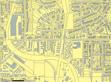
2 Theme The activity node encompasses the area bounded by Donald Lee Hollowell Parkway to the north, Martin Luther King, Jr. Drive to the south, Northside Drive to the east and Chappell Road to the west. Joseph E. Lowry Boulevard, running north/south and, running east/west are the major streets bisecting the area. The area is inside the two historic Beltline routes of the Atlanta, Birmingham & Coastline Railroad to the east and the Louisville & Nashville Railroad to the west. There are several neighborhoods in the area: English Avenue is located in the northeast quadrant of the Lowry/Simpson intersection; Vine City is located in the southeast quadrant; and Washington Park makes up the southeast quadrant. The Hunter Hills neighborhood is to the west of Washington Park. The Grove Park neighborhood lies just outside the node area to the northwest. There are two parks in the node, Maddox Park, through which the Louisville & Nashville line ran, and Washington Park. This area developed slowly into the late 1800s and in the early 1900s it began to become a quickly growing suburban area of bungalow neighborhoods for lower to middle class working people, both white and African American. The businesses that developed in the area were generally small in nature and supported the surrounding neighborhoods. They were particularly concentrated around the major intersection of and Joseph E. Lowry (formerly Ashby Street), and along Martin Luther King, Jr. Boulevard (formerly Hunter) and to a lesser extent along Donald Lee Hollowell Parkway (formerly Bankhead Highway). The small number of industrial businesses that existed were concentrated around the rail lines and particularly along Donald Lee Hollowell. Developmental History The earliest known settlement in the area is that of the Jett family, in what is now the English Avenue neighborhood, sometime in the mid-1800s, when Atlanta was still called Marthasville. At that time, the larger area was known as NashBans, after two of the major roads in the area. By 1844, a ferry had been established along the Chattahoochee River, to which Mayson Ferry Road (which became Mayson Turner Road) was the route from Atlanta. The area that would become Washington Park was being established at this time by two white farmers, H.F. Emery and G.W. Elliott. The area did not see any battles during the Civil War, however, General Sherman had headquarters located southwest of the present Maddox Park, during the siege of Atlanta. The remains of defensive fortifications were found in this area, which later became the Grove Park neighborhood, originally called Fortified Hills. Following the Civil War, Atlanta began to reach this area as its population grew. Atlanta University was built in 1869 in what was still the outskirts of Atlanta, but would soon be a vibrant and growing area. In the early 1870s the Vine City neighborhood began to develop, originally by whites. By 1884, the city of Atlanta had a municipal dump in the area that would become Maddox Park Birdseye View Map, 78

3 By the time of the 1886 Atlanta city directory, which was also the first year of the Sanborn Fire Insurance Maps, this area was almost completely residential, and that was predominantly white. The area did not extend very far past Joseph Lowry Boulevard, which was then Ashby Street. The English Avenue neighborhood had grown enough to that point to require an elementary school to be built in 1888, the Gray Street School, later named Craddock Elementary. This was the first brick school built in Atlanta for African Americans, who had begun moving in to the area following the Civil War. In 1889, the Bankhead or Bellwood neighborhood was plotted at the end of the street car line along what is now Donald Lee Hollowell Parkway, formerly Bankhead Highway Sanborn Map, on edge of city, growing westward 1911 Sanborn Map, Simpson Road growing westward toward the Louisville and Nashville rail line By the time of the 1900 Atlanta City Directory, the roads in the area stretched further west just past the rail line. Most of the area was still predominantly white, however, along Martin Luther King, Jr. Drive, which was Hunter at that time, the area from Davis Street running west had become predominantly African American. There were still very few businesses in the area and those that existed were small enterprises such as grocers and barbers. There was a great deal of development in the 1910s. Grove Park was being developed at this time. Several schools were built throughout the area. The number of African American listings in the city directories was growing, as were listings for small businesses. By 1912, there were two major trolley lines running along the boundaries of the English Avenue neighborhood. One ran along what is now Northside Drive to Kennedy to English Avenue. The other ran along Hunter to Ashby and then north to Bankhead Highway. These lines created a racial divide. Whites tended to live inside these lines, while African Americans for the most part lived outside. Ashby Street in particular was a color line for the area, with African Americans generally living to the west of it. The 1920s saw tremendous growth in the area, particularly among African American population and business. Washington Park, the park itself, was developed from 1919 to 1926, after lengthy petitioning by African Americans to the Atlanta City Council for a park of their own. The park provided a pool, bathhouse, restrooms and concession stands specifically for African Americans in the neighborhood. Heman Perry, who founded the Citizen Trust Company in 1921 and who had already risen to prominence as an African American entrepreneur in the Sweet Auburn area, purchased and then sold property along Ashby Street, to encourage African American settlement and business in the area. The Bankhead Library was built in 1922 along Bankhead Highway. The land for the library had been obtained from St. Lukeís Methodist Episcopal Church, an African American church. The library was built with a grant from the Carnegie Foundation as an expansion of Atlantaís public library system. There are no records to indicate that it was built specifically for African American use. 79


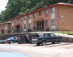
4 Not long after, a branch of the Salvation Army was built across the street from the library. Booker T. Washington High School was constructed in 1924 to support the growing African American population. By the later 1920s, Maddox Park was being developed over what had been the Atlanta Municipal Dump. The swimming pool and gazebo in the park were built in Maddox Park Pavilion, constructed 1931 Through the 1940s and 1950s, the African American population was steadily increasing in this area. The English Avenue neighborhood saw the largest increase in African American population in the city of Atlanta in the 1940s. The late 1940s and into the 1950s saw the expansion of business in the area, especially around Simpson Road and Ashby Street intersections. Beginning in the late 1950s and into the 1960s, garden apartments began to be constructed as the population grew. These were especially concentrated along. In the late 1960s and into the 1970s, the population of the area, particularly of white residents, began to decline. Vine City, which had been one of the most prestigious addresses for African Americans in Atlanta, became mostly occupied by the unemployed and manual laborers, and since 1970, has lost 56% of its former population. The English Avenue neighborhood began to decline sharply into the 1980s, and currently, over half of its population lives in poverty. This trend was not confined to English Avenue but was felt in the entire Node area. Physical Description Intersection of Bankhead Highway and Ashby Street, 1955 Today, the area still retains the general characteristics of its past, although with far less glory. Donald Lee Hollowell Parkway, formerly Bankhead Highway, remains mainly industrial with interspersed commercial buildings. There are many vacant buildings and lots along the road. The Bankhead Library remains at the corner of English Avenue, although it is boarded up. Behind it, the English Avenue School likewise remains, boarded and empty. The English Avenue neighborhood itself is perhaps the most depressed of the area neighborhoods. There are vacant lots scattered throughout, and many homes are in poor repair. Throughout most of the neighborhoods, commercial buildings remain on many corners, which in many cases were grocery stores. Intersection of Jefferson Street and Griffen Street, 1954 has remained largely commercial. Many former commercial buildings are vacant. There is a very large vacant area, approximately 2 blocks in total, at the eastern end of the street towards Northside Drive. The garden apartments which remain are in fairly poor repair but appear to be structurally sound. Homes remain scattered along Simpson, many in poor condition. 80

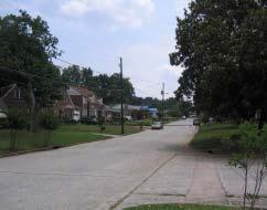
5 Martin Luther King, Jr. Drive also has many vacant commercial buildings along its length. Moving west past Booker T. Washington High School however, the Washington Park neighborhood remains in reasonable repair with many attractive mature trees. Likewise, the Vine City neighborhood has retained more homes in reasonable repair than not, although there area scattered vacant lots throughout both neighborhoods. Lowry Boulevard remains largely residential with scattered commercial areas, particularly around the intersections of Martin Luther King, Jr. Drive, and Hollowell Parkway. There are many significant resources which remain in the area. The neighborhoods are generally made up of small bungalows with craftsman details, or what is called the American small house. Vine City has some examples of larger, two story homes, with varying architectural styles. The landscaping and mature trees of the neighborhoods are important characteristics of the area. Many of the areaís churches are over 50 years old. Most are still active, while several are currently vacant. Significantly contributing garden apartments include apartments at 1177, built in 1957; Fairway Court Apartments at 1247, built in 1960; Trafalgar Square, at 1155, built in 1962; and the Chappell Forest Apartments at 425 Chappell Road, built in These could potentially be eligible for listing on the National Register as a group nomination. There are quite a number of significant commercial buildings in the area. Although most do not have connections to prominent people or events, they are important in retaining the character of the area ñ somewhat self sufficient neighborhoods outside the larger city. The corner store buildings which remain in many intersections speak to this character. Most of the truly significant commercial buildings remain on Martin Luther King, Jr. Drive and along Joseph E. Lowry Boulevard. These include the William A. Harris Memorial Hospital, a one story colonial revival built in 1930; the Ashby Street Theatre, a two story masonry colonial revival built in 1925; the Citizen Trust Company West Side Branch bank building, a two story international style building constructed in 1955; and the Calloway Building, also a two story international style building constructed in These four buildings are all located on Martin Luther King, Jr. Drive near the Joseph E. Lowry intersection. Many of these buildings could be eligible for the National Register as a multi-structure listing. The other commercial buildings in the area follow the styles and appearances of these, generally constructed in the 1920s-30s and the 1950s. 708 Jefferson Street, Guardian Chemical Company, constrcuted in 1890 There are a number of significant schools in the area. Booker T. Washington High School, built in 1924, was listed on the National Register in Other historic schools include E.R. Carter Elementary, a three story brick building built in 1910, and the English Avenue School, a three story brick building with gothic details, also built in Several historically contributing commercial and industrial buildings, possibly eligible for listing the National Register, remain on Donald Lee Hollowell Parkway, near the rail line. A number are currently vacant. Others still house businesses such as the Bearden- Thompson Electric Company at 1085 Hollowell, and the Beavers Rebuilt & Guaranteed Appliance, at 1435 Hollowell, both constructed in the 1940s. 81

6 Conclusion There is a great opportunity for development in the area. The area greatly needs economic revitalization to realize a return to its vibrant past. The development however, must be in keeping with the historical character of the area. There is a great deal of room for infill housing, as well as some scattered housing which probably could be safely demolished for health and safety reasons. The infill housing should be in keeping with the nature of surrounding homes in being fairly small and not too densely constructed. Most of the garden apartments which remain appear to be structurally sound and perhaps only need some general repair and maintenance. Because these apartments represent the highest density housing in the area, their character must direct future higher density housing. High-rise apartments or condominiums are not compatible with the character of the area. Perhaps four or five stories at the very most would English Avenue School, constructed in 1922 be acceptable, and that should be concentrated along and other major roads where there is already a mix of residential and commercial use. The vacant English Avenue School would be a very good resource to rehabilitate for higher density housing, as well as any vacant industrial buildings. The majority of the commercial structures in the area appear to be structurally sound and ready for rehabilitation and reuse for a variety of purposes. The many vacant corner store buildings could be put to use as corner grocery stores again, or restaurants or even apartments or condominiums. Because of the current condition of Hollowell Parkway, with many vacant buildings and lots, and because of its historic industrial and commercial nature, this would be a good location for denser commercial, even residential development, or mixed use. 82
2014 Plan of Conservation and Development
 The Town of Hebron Section 1 2014 Plan of Conservation and Development Community Profile Introduction (Final: 8/29/13) The Community Profile section of the Plan of Conservation and Development is intended
History of Spruce Hill. The history of West Philadelphia s Spruce Hill neighborhood roughly bordered
 Lauren Pinsker October 11, 2005 Hist 204.402 / Urbs 227.402 History of Spruce Hill The history of West Philadelphia s Spruce Hill neighborhood roughly bordered by Walnut Street to the north, 41 st Street
OFFICIAL COMMUNITY PLAN. PART B.1 Northeast Area Neighbourhood Plan
 OFFICIAL COMMUNITY PLAN PART B.1 Northeast Area Neighbourhood Plan 1) Context The Design Regina Plan, under the authority of The Planning and Development Act, 2007 (as amended), provides for the adoption
4.2.8 Westwood/VA Hospital Station Area
 4.2.8 Westwood/VA Hospital Station Area The Westwood/VA Hospital Station area is north of the VA Hospital and surrounded by large, open landscaped areas and several parking lots. I-405 is a prominent visual
Ch. 14 CAPITOL HILL. Historic Districts - Apartment and Multi-family Development
 Historic Districts - Apartment and Multi-family Development Ch. 14 CAPITOL HILL A HISTORY OF APARTMENT AND MULTI-FAMILY DEVELOPMENT The following background on the historical development of apartment and
Ch.16 SOUTH TEMPLE. Historic Districts - Apartment and Multi-family Development A HISTORY OF APARTMENT AND MULTI-FAMILY DEVELOPMENT
 Historic Districts - Apartment and Multi-family Development Ch.16 SOUTH TEMPLE A HISTORY OF APARTMENT AND MULTI-FAMILY DEVELOPMENT The following background on the historical development of apartment and
Flatbush Rezoning and Text Amendments LR Item 3: Description of Proposal
 Project Description The New York City Department of City Planning (DCP), at the request of Community Board 14, elected officials and civic groups, proposes zoning map changes and zoning text amendments
Introduction. Charlotte Fagan, Skyler Larrimore, and Niko Martell
 Charlotte Fagan, Skyler Larrimore, and Niko Martell Introduction Powderhorn Park Neighborhood, located in central-southern Minneapolis, is one of the most economically and racially diverse neighborhoods
2.2.2 The Land Use Setting
 2-6 Planning Area pearance varies dramatically from season to season. The absence of significant topographic or man-made features within the District contributes to a very open visual character that allows
410 Land Use Trends Comprehensive Plan Section 410
 411 410 Comprehensive Plan Section 410 In order to plan future land use, we must know how the land is used today. This section includes the following: Definition of analyzed land-use categories Summary
Existing Land Use. Typical densities for single-family detached residential development in Cumberland County: 1
 Existing Land Use A description of existing land use in Cumberland County is fundamental to understanding the character of the County and its development related issues. Economic factors, development trends,
Chapter 9 Multiple Choice Questions
 Chapter 9 Multiple Choice Questions / Page 1 Chapter 9 Multiple Choice Questions 1. The text argues that students of real estate should study factors that influence demand at the national, regional, community
III. Apartment HISTORIC DISTRICTS. & Multifamily Development
 III HISTORIC DISTRICTS Apartment & Multifamily Development PART III Historic Districts APARTMENT & MULTIFAMILY DEVELOPMENT CH. 13 THE AVENUES 13 : 1-6 CH. 14 CAPITOL HILL 14 : 1-6 CH. 15 CENTRAL CITY 15
Dan Immergluck 1. October 12, 2015
 Examining Recent Declines in Low-Cost Rental Housing in Atlanta, Using American Community Survey Data from 2006-2010 to 2009-2013: Implications for Local Affordable Housing Policy Dan Immergluck 1 October
COMMUNICATION URBAN DESIGN REVIEW BOARD CITY OF DES MOINES, IOWA NOVEMBER 1, 2016, 2016 MEETING
 COMMUNICATION URBAN DESIGN REVIEW BOARD CITY OF DES MOINES, IOWA NOVEMBER 1, 2016, 2016 MEETING Subject: Recommendation Prepared by: PRELIMINARY DESIGN AND FINANCIAL REVIEW 401 SE 6 TH STREET- CONNOLLY
A. Land Use Relationships
 Chapter 9 Land Use Plan A. Land Use Relationships Development patterns in Colleyville have evolved from basic agricultural and residential land uses, predominate during the early stages of Colleyville
Memorandum. Historic Resources Inventory Survey Form 315 Palisades Avenue, 1983.
 Memorandum TO: Roxanne Tanemori, City of Santa Monica DATE: August 30, 2007 CC: FROM: Jon L. Wilson, M.Arch., Architectural Historian RE: Preliminary Historic Assessment: 315 Palisades Avenue (APN 4293-015-015)
West Whiteland Township Historical Commission Agenda March 13, 2017
 West Whiteland Township Historical Commission Agenda March 13, 2017 6:30 P.M. WORK SESSION CANCELLED THIS MONTH 7 P.M. Business Meeting I. Call to Order II. III. Public Comment Old Business There is no
STAFF REPORT. January 25, North York Community Council. Director, Community Planning, North District
 STAFF REPORT January 25, 2005 To: From: Subject: Purpose: North York Community Council Director, Community Planning, North District Refusal Report OPA & Rezoning Application 04 194214 NNY 33 OZ Applicant:
Windshield Survey of McLoud, Pottawatomie County. September 12, 2007 By Jim Gabbert Architectural Historian OK/SHPO
 Windshield Survey of McLoud, Pottawatomie County September 12, 2007 By Jim Gabbert Architectural Historian OK/SHPO Purpose and Methodology The purpose of this windshield survey is to identify, based on
Plan Area and Current Facilities
 Plan Area and Current Facilities The Plan Area is bounded by South Delaware Street to the east and Concar Drive to the south (Figure 2.01). Parallel to Concar Drive on the south, SR 92 rises above grade
City of Exeter Housing Element
 D. Housing Stock Characteristics Government Code Section 65583(a) requires an analysis and documentation of household characteristics, including level of payment compared to ability to pay, housing characteristics,
WASHTENAW COUNTY BROWNFIELD REDEVELOPMENT AUTHORITY ACT 381 WORK PLAN TO CONDUCT ELIGIBLE DEQ RESPONSE AND/OR MSF NON-ENVIRONMENTAL ACTIVITIES
 WASHTENAW COUNTY BROWNFIELD REDEVELOPMENT AUTHORITY ACT 381 WORK PLAN TO CONDUCT ELIGIBLE DEQ RESPONSE AND/OR MSF NON-ENVIRONMENTAL ACTIVITIES 400 NORTH RIVER STREET THE HISTORIC THOMPSON BLOCK REDEVELOPMENT
Enlightened Urbanism: A Model for Development of Vacant Buildings Downtown
 Enlightened Urbanism: A Model for Development of Vacant Buildings Downtown Amanda Phelps What is needed is not a new utopia... but rather a blueprint for a better reality. 1 O.M. Ungers San Antonio is
ZIMMERMAN/VOLK ASSOCIATES, INC.
 ZIMMERMAN/VOLK ASSOCIATES, INC. Post Office Box 4907 Clinton, New Jersey 08809 908 735-6336 info@zva.cc www.zva.cc Research and Strategic Planning Presented by: Laurie Volk Co-Managing Director Zimmerman/Volk
Brief History of Land Use Planning Policy in the United States
 Brief History of Land Use Planning Policy in the United States Planning Based on Transportation Concerns Early adoption of privatized transportation (automobiles) over public mass-transit options. Spatial
Greater Downtown Tuscaloosa Historic Resources
 Greater Downtown Tuscaloosa Historic Resources www.shphistoric.com Contents Summary...1 Historic Resource Survey Methodology...2 General Information...3 Previous Documentation...3 Historic Resources Within
2004 Penner & Associates
 2004 2004 Penner & Associates Business Park Expense Category Percentages MEDIAN OPERATING EXPENSES Mgnt Fee 15% Miscellaneous 5% Taxes 29% Repairs & Maintenance 22% Grounds Maintenance 7% Trash Removal
CASS COUNTY MASTER PLAN July 1, Appendix C LAND USE
 Appendix C LAND USE Introduction Existing land use and development patterns in Cass County are important considerations in the development of policies addressing future growth and land use. Existing land
Site Analysis. Community Analysis. Section 3A Page 1
 Section 3A Page 1 Section 3A Page 2 The area known as East Central City began as one of the first suburban expansions outside the planned city of Columbia S.C. This expansion began in the 1890 s in what
mmrma BIMONTHLY PUBLICATION OF THE FARM MANAGEMENT STAFF Indiana Land Prices and Cash Rents J. H. Atkinson, Professo; of Agricultural Economics.
 .. g - ~- mmrma BIMONTHLY PUBLICATION OF THE FARM MANAGEMENT STAFF - G. A. HARRISON & J. H. ATKINSON, EDITORS August, 1978 AGRICULTURAL ECONOMICS DEPARTMENT. PURDUE UNIVERSITY '- Indiana Land Prices and
I 1-1. Staff Comment Form. Heritage Impact Assessment 7764 Churchville Road (Robert Hall House)
") I 1-1 Staff Comment Form Date: March 25, 2013 To: The Brampton Heritage Board Property: Applicant: Daniel Colucci and Larysa Kasij Brampton Heritage Board Date: April 16, 2013 Subject: Heritage Impact
I 1-1 Staff Comment Form Date: March 25, 2013 To: The Brampton Heritage Board Property: Applicant: Daniel Colucci and Larysa Kasij Brampton Heritage Board Date: April 16, 2013 Subject: Heritage Impact
Chapter AGRICULTURAL DISTRICT A-1
 Chapter 18.20 AGRICULTURAL DISTRICT A-1 Sections: 18.20.010 Permitted uses. 18.20.020 Conditional uses. 18.20.010 Permitted uses Permitted uses in the A-1 district are: Single-family residence General
UNDERSTANDING THE TAX BASE CONSEQUENCES OF LOCAL ECONOMIC DEVELOPMENT PROGRAMS
 UNDERSTANDING THE TAX BASE CONSEQUENCES OF LOCAL ECONOMIC DEVELOPMENT PROGRAMS Richard K. Gsottschneider, CRE President RKG Associates, Inc. 277 Mast Rd. Durham, NH 03824 603-868-5513 It is generally accepted
Residential Capacity Estimate
 Residential Capacity Estimate Montgomery County Department of Park & Planning Research & Technology Center January 2005 Current plans allow 75,000 more housing units. by Matthew Greene, Research Planner
Appendix A. Factors Affecting City Expenditures
 Appendix A Factors Affecting City Expenditures Factors Affecting City Expenditures The finances of cities are affected by many different factors. Some of the variation results from decisions made by city
P o p u l a t i o n, L a n d U s e, a n d Z o n i n g
 P o p u l a t i o n, L a n d U s e, a n d Z o n i n g The Town of Upper Marlboro is located only 15 miles southeast of the District of Columbia, in the central portion of Prince George s County in the
JEFFERSON COUNTY, WEST VIRGINIA Office of Planning and Zoning 116 East Washington Street, 2 nd Floor P.O. Box 716 Charles Town, WV 25414
 JEFFERSON COUNTY, WEST VIRGINIA Office of Planning and Zoning 116 East Washington Street, 2 nd Floor P.O. Box 716 Charles Town, WV 25414 www.jeffersoncountywv.org Email: planningdepartment@jeffersoncountywv.org
Affordability First: Concerns about Preserving Housing Options for Existing and New Residents on Atlanta s Westside
 Affordability First: Concerns about Preserving Housing Options for Existing and New Residents on Atlanta s Westside Recent Trends in Median Rents on the Westside Dan Immergluck Professor School of City
Introduction. Sidney Ainkorn, Peter Mathison, and David Tomporowski. General History and Context. Geographic Context
 Sidney Ainkorn, Peter Mathison, and David Tomporowski Introduction General History and Context Geographic Context Richfield is a first-ring suburb, located just outside the city of Minneapolis (Map 1).
2) COMPREHENSIVE PLAN AMENDMENT
 COMPREHENSIVE PLAN AMENDMENT") The Inwood Road Corridor, (Sector 2) COMPREHENSIVE PLAN AMENDMENT In 2016, the City Council approved a contract with M. Arthur Gensler Jr. And Associates, Inc. (Gensler) to facilitate a special study process
The Inwood Road Corridor, (Sector 2) COMPREHENSIVE PLAN AMENDMENT In 2016, the City Council approved a contract with M. Arthur Gensler Jr. And Associates, Inc. (Gensler) to facilitate a special study process
LAND USE. As such, the Township has estasblished the following statement of objectives for future development within its borders:
 LAND USE When creating a land use plan, a municipality should consider a process which firsts determines future population figures, whether growth or decline, and its targeted areas within the municipal
To achieve growth, property development, redevelopment and an improved tax base in the cities and boroughs in the Lehigh Valley.
 Most growth in property valuation is in townships. Between 1991 and 2004, the assessed valuation of the townships in the Lehigh Valley increased by more than $2.8 billion, an increase of 41%. At the same
PATRICK J. SULLIVAN DIRECTOR
 City of New Bedford Department of Planning, Housing & Community Development 608 Pleasant St, New Bedford, Massachusetts 02740 Telephone: (508) 979.1500 Facsimile: (508) 979.1575 PATRICK J. SULLIVAN DIRECTOR
Board of Zoning and Planning Members. Justin A. Milam, AICP, Planning Officer. Positive recommendation of a rezoning to City Council.
 To: From: Board of Zoning and Planning Members Justin A. Milam, AICP, Planning Officer Prepared for Meeting Dated: Tuesday, February 19, 2013 Subject: Action Requested: Master Plan Objective: BZAP review
BRUNSWICK APARTMENT MARKET
 July 2016 BRUNSWICK APARTMENT MARKET Occupancy Trends Current research into the Brunswick apartment market indicates continuation of the favorable conditions reported in our May 2015 publication. Occupancy
CITY PLANNING COMMISSION CITY OF NEW ORLEANS EXECUTIVE DIRECTOR. City Planning Commission Staff Report. Executive Summary
 CITY PLANNING COMMISSION CITY OF NEW ORLEANS MITCHELL J. LANDRIEU MAYOR ROBERT D. RIVERS EXECUTIVE DIRECTOR LESLIE T. ALLEY DEPUTY DIRECTOR City Planning Commission Staff Report Zoning Docket 092/16 Executive
Lied Institute Report on Apartment Market Trends featuring data from the Center for Business and Economic Research
 Volume 7, 3 rd Quarter, 2014 Lied Institute Report on featuring data from the Center for Business and Economic Research in 3 rd Quarter 2014 Las Vegas s apartment market saw small quarterly decreases in
VOLUME 24 NUMBER 2 JANUARY-MARCH 1994 RESIDENTIAL WILDWOOD GABLES ATLANTA, GEORGIA PROJECT TYPE
 VOLUME 24 NUMBER 2 JANUARY-MARCH 1994 RESIDENTIAL WILDWOOD GABLES ATLANTA, GEORGIA PROJECT TYPE Wildwood Gables is an example of the creative redevelopment of a 421 unit, Class D garden property that was
Smart Growth in Mercer Island s Town Center
 Smart Growth in Mercer Island s Town Center Mercer Island Town Center History Just over five miles long and two miles wide, Mercer Island is an island community located in Lake Washington between the cities
Downtown Brampton and Queen Street Corridor: Residential and Commercial Projects
 Downtown Brampton and Queen Street Corridor: Residential and Commercial Projects What Makes a Great Downtown The economic and cultural vitality of the city depends on a robust downtown and central corridor.
Sherwood Forest (Trinity) Housing Corporation. Urban Design Brief
 Housing Corporation. Urban Design Brief") Sherwood Forest (Trinity) Housing Corporation Sherwood Place Affordable Housing Apartments Trinity Presbyterian Church Orchard Park Nursery School 590 Gainsborough Road, London Urban Design Brief REVISED
Sherwood Forest (Trinity) Housing Corporation Sherwood Place Affordable Housing Apartments Trinity Presbyterian Church Orchard Park Nursery School 590 Gainsborough Road, London Urban Design Brief REVISED
ORDINANCE NO (As Amended)
") ORDINANCE NO. 01-2015 (As Amended) To Amend the Official Zoning Map of the City of Worthington, Ohio, to Change Zoning of Certain Land from the C-3 District (Institutions and Office), AR-4.5 District (Low
ORDINANCE NO. 01-2015 (As Amended) To Amend the Official Zoning Map of the City of Worthington, Ohio, to Change Zoning of Certain Land from the C-3 District (Institutions and Office), AR-4.5 District (Low
Linkages Between Chinese and Indian Economies and American Real Estate Markets
 Linkages Between Chinese and Indian Economies and American Real Estate Markets Like everything else, the real estate market is affected by global forces. ANTHONY DOWNS IN THE 2004 presidential campaign,
Hamilton County Regional Planning Commission
 Hamilton County Regional Planning Commission March 1, 2012 Colerain Township Staff Report Zone Map Amendment: Case No.: ZA2012-01 Joseph Toyota Prepared By: Amy Bancroft, Land Use Planner ACTION REQUESTED:
RC ; Reclassification The Garrison at Stafford Proffer Amendment (formerly Stafford Village Center)
") Board of Supervisors Robert Bob Thomas, Jr., Chairman Laura A. Sellers, Vice Chairman Meg Bohmke Jack R. Cavalier Wendy E. Maurer Paul V. Milde, III Gary F. Snellings Anthony J. Romanello, ICMA CM County
Board of Supervisors Robert Bob Thomas, Jr., Chairman Laura A. Sellers, Vice Chairman Meg Bohmke Jack R. Cavalier Wendy E. Maurer Paul V. Milde, III Gary F. Snellings Anthony J. Romanello, ICMA CM County
Submitted to Fire Station 8 Working Group and Arlington County Public Library HOUSE AT 2211 NORTH CULPEPER STREET
 Submitted to Fire Station 8 Working Group and Arlington County Public Library HOUSE AT 2211 NORTH CULPEPER STREET Location: 2211 North Culpeper Street, Arlington, Virginia. Significance: The house at 2211
COMMERCIAL ELEMENT AND CODE ENFORCEMENT
 COMMERCIAL ELEMENT AND CODE ENFORCEMENT The Commercial Element identifies and describes the existing characteristics that are desired by the neighborhood. The existing conditions will determine appropriate
POPULATION FORECASTS
 POPULATION FORECASTS Between 2015 and 2045, the total population is projected to increase by 373,125 residents to reach 2.2 million. Some areas will see major increases, while other areas will see very
Table of Contents. Appendix...22
 Table Contents 1. Background 3 1.1 Purpose.3 1.2 Data Sources 3 1.3 Data Aggregation...4 1.4 Principles Methodology.. 5 2. Existing Population, Dwelling Units and Employment 6 2.1 Population.6 2.1.1 Distribution
APPENDIX C CHARACTERISTICS OF THE ENERGIZE PHOENIX CORRIDOR
 APPENDIX C CHARACTERISTICS OF THE ENERGIZE PHOENIX CORRIDOR BACKGROUND ON RESIDENTIAL AND COMMERCIAL BUILDINGS IN THE EP CORRIDOR The 10-mile EP corridor (Figure G1) is a highly diverse, mixed-use L-shaped
THE IMPACT OF RESIDENTIAL REAL ESTATE MARKET BY PROPERTY TAX Zhanshe Yang 1, a, Jing Shan 2,b
 THE IMPACT OF RESIDENTIAL REAL ESTATE MARKET BY PROPERTY TAX Zhanshe Yang 1, a, Jing Shan 2,b 1 School of Management, Xi'an University of Architecture and Technology, China710055 2 School of Management,
INTRODUCTION... 1 EXISTING CONDITIONS... 3
 TABLE OF CONTENTS INTRODUCTION... 1 EXISTING CONDITIONS... 3 DEMOGRAPHICS... 3 URBAN FORM... 5 LAND USE... 7 Residential...11 Commercial...12 Institutional...12 TRANSPORTATION...16 STUDY AREAS...19 PLAN
Southeast Los Angeles Non-Parcel Resources - March 2012
 Non-Parcel Resources 43rd street between McKinley and Avalon 43rd Street palm trees Year built: 1905 Context: Residential Development and Suburbanization, 1850-1980 Theme: Automobile Suburbanization, 1908-1937
STAFF REPORT NEW BEDFORD HISTORICAL COMMISSION MEETING July 10, 2017
 PATRICK J. SULLIVAN DIRECTOR City of New Bedford Department of Planning, Housing & Community Development 608 Pleasant St, New Bedford, Massachusetts 02740 Telephone: (508) 979.1500 Facsimile: (508) 979.1575
Poten ally Eligible Structures
 Poten ally Eligible Structures (Note: Construction dates for many properties are based on County Assessor s records and have not been verified by historical research.) Fifteen commercial or public buildings
Detroit Neighborhood Housing Markets
 Detroit Neighborhood Housing Markets Market Study 2016 In 2016, Capital Impact s Detroit Program worked with local and national experts to determine the residential market demand across income levels for
Generic Environmental Impact Statement. Build-Out Analysis. City of Buffalo, New York. Prepared by:
 Generic Environmental Impact Statement Build-Out Analysis City of Buffalo, New York 2015 Prepared by: TABLE OF CONTENTS 1.0 INTRODUCTION 1 2.0 METHODOLOGY 2 3.0 EXISTING LAND USE 3 4.0 EXISTING ZONING
Memorandum. Overview. Background Information. To: Scott Albright, City of Santa Monica Date: 04/22/2013 Jan Ostashay, Principal OAC
 Memorandum P.O. Box 542 Long Beach, CA 562.500.9451 HISTORICS@AOL.COM To: Scott Albright, City of Santa Monica Date: 04/22/2013 From: Jan Ostashay, Principal OAC Re: PRELIMINARY HISTORICAL ASSESSMENT:
STAFF SUMMARY OF Z17-10 CONDITIONAL ZONING DISTRICT APPLICATION
 STAFF SUMMARY OF Z17-10 CONDITIONAL ZONING DISTRICT APPLICATION APPLICATION SUMMARY Case Number: Z17-10 Request: Conditional B-2 Zoning District in order to expand an existing retail and warehousing business
Downtown Brampton and Queen Street Corridor: Residential and Commercial Projects
 Downtown Brampton and Queen Street Corridor: Residential and Commercial Projects What Makes a Great Downtown The economic and cultural vitality of the city depends on a robust downtown and central corridor.
CLARK COUNTY NEIGHBORHOOD REVITALIZATION PLAN. Effective Date. January 1, Revised
 CLARK COUNTY NEIGHBORHOOD REVITALIZATION PLAN Effective Date January 1, 2007 Revised January 1, 2010 KANSAS NEIGHBORHOOD REVITALIZATION ACT K.S.A. 1996 Supp. 12-17, 114 et seq. This law authorizes any
COOK ROAD AT VANIER ROAD AYLMER (GATINEAU), QUÉBEC
, QUÉBEC") PRIMECORP COMMERCIAL QUÉBEC INC., REAL ESTATE AGENCY DAVID THOMSON * B.A. FRI Certified Real Estate Broker Manager of Québec Operations 819.664.5275 dthomson@primecorp.ca * practicing within David C. Thomson
PRIMECORP COMMERCIAL QUÉBEC INC., REAL ESTATE AGENCY DAVID THOMSON * B.A. FRI Certified Real Estate Broker Manager of Québec Operations 819.664.5275 dthomson@primecorp.ca * practicing within David C. Thomson
Memorandum. 233 Wilshire Boulevard, Suite 130, Santa Monica, CA INTERNET TEL FAX
 TO: Scott Albright, City of Santa Monica DATE: April 29, 2010 CC: FROM: PCR Services RE: PRELIMINARY HISTORIC ASSESSMENT: 2501 2ND TH STREET, APN As requested by City s staff, PCR Services Corporation
ORDINANCE NO AN ORDINANCE AMENDING THE URBANA ZONING MAP. (Rezoning Multiple Properties to B-4 / Plan Case No.
 Passed: March 05, 2018 Signed: March 06, 2018 ORDINANCE NO. 2018-03-019 AN ORDINANCE AMENDING THE URBANA ZONING MAP (Rezoning Multiple Properties to B-4 / Plan Case No. 2329-M-18) WHEREAS, the Urbana Zoning
Housing, Retail and Arts
 Summary of Findings & Conclusions West Oakland Specific Plan Market Opportunity Report: Housing, Retail and Arts Prepared for City of Oakland Under subcontract to JRDV Architects DECEMBER 2011 Summary
3. FISCAL IMPACT ANALYSIS FISCAL IMPACT ANALYSIS 29
 3. FISCAL IMPACT ANALYSIS FISCAL IMPACT ANALYSIS 29 The purpose of fiscal impact analysis is to estimate the impact of a development or a land use change on the budgets of governmental units serving the
PLANNING AND IMPLEMENTING TOD: KEY FACTORS FOR SUCCESS. Sujata Srivastava Knowledge Corridor TOD Workshop June 5, 2013
 PLANNING AND IMPLEMENTING TOD: KEY FACTORS FOR SUCCESS Sujata Srivastava Knowledge Corridor TOD Workshop June 5, 2013 6-year old partnership dedicated to improving practice through technical assistance,
DEPARTMENT OF PLANNING & ZONING COMPREHENSIVE PLANNING LAND PRESERVATION FOREST CONSERVATION GIS
 DEPARTMENT OF PLANNING & ZONING COMPREHENSIVE PLANNING LAND PRESERVATION FOREST CONSERVATION GIS September 8, 2017 Case #: RZ-17-005 Application for Map Amendment Staff Report and Analysis Property Owner(s)
Venice Report Historic Districts, Planning Districts and Multi-Property Resources 04/02/15
 Districts Name: Lost Venice Canals Historic District Description: The Lost Venice Canals Historic District is a residential neighborhood located in the northwestern portion of Venice. The district contains
Burlington Unincorporated Community Plan
 Burlington Unincorporated Community Plan June 30, 2010 Meeting Page 1 of 24 Table of Contents (Page numbers to be inserted) I. Background a. Location and Community Description b. Planning of Unincorporated
(OUSING 0ROPOSAL -OUNT!UBURN
 (OUSING 0ROPOSAL -OUNT!UBURN 0ROPOSED )NTERVENTIONS )NWOOD 6ILLAGE )NWOOD 0ARK 4HE #OMMONS )NWOOD )NWOOD ON 6INE!UBURN!RTS $ISTRICT *ACKSON "OULEVARD %RIC #ASH!UTUMN 1UARTER 5NIVERSITY OF #INCINNATI.IEHOFF
TABLE OF SPECIAL ORDINANCES I. ANNEXATIONS BOND ISSUES CONDEMNATIONS EASEMENTS V. FRANCHISES STREET SYSTEM ZONING MAP CHANGES
 TABLE OF SPECIAL ORDINANCES Table I. ANNEXATIONS II. III. IV. BOND ISSUES CONDEMNATIONS EASEMENTS V. FRANCHISES VI. VII. VIII. INTERLOCAL COOPERATION AGREEMENTS STREET SYSTEM ZONING MAP CHANGES 1 2 West
ASSIGNMENT 4: URBAN DESIGN AND HOUSING DESIGN
 ASSIGNMENT 4: URBAN DESIGN AND HOUSING DESIGN Mt. Auburn Vision Statement: To build a vital neighborhood identity for a self sustaining community through the use of existing resources. Intervention Intentions
WRT. October 16, Arthur Collins President Collins Enterprises, LLC 2001 West Main Street, Suite 175 Stamford, CT 06902
 Planning & Design October 16, 2010 Arthur Collins President Collins Enterprises, LLC 2001 West Main Street, Suite 175 Stamford, CT 06902 Re: Review of The Landmark at Talbot Park Philadelphia Dallas Lake
Director, Community Planning, North York District
 STAFF REPORT ACTION REQUIRED 32-50, 52, 55, 56, 59, 60, 62, 65, 66, 70, 72, 76, 80, 85 & 90 Forest Manor Road, 100, 106, 110, 123, 123A, 125 and 130 Parkway Forest Drive, 1751 and 1761 Sheppard Avenue
Annual (2013) Review of the Surrey Official Community Plan
 Review of the Surrey Official Community Plan") CORPORATE REPORT NO: R118 COUNCIL DATE: JUNE 23, 2014 REGULAR COUNCIL TO: Mayor & Council DATE: June 23, 2014 FROM: General Manager, Planning and Development FILE: 6440-01 SUBJECT: Annual (2013) Review
CORPORATE REPORT NO: R118 COUNCIL DATE: JUNE 23, 2014 REGULAR COUNCIL TO: Mayor & Council DATE: June 23, 2014 FROM: General Manager, Planning and Development FILE: 6440-01 SUBJECT: Annual (2013) Review
Guide to the Mobile Housing Board Records
 Guide to the Mobile Housing Board Records Descriptive Summary: Creator: Various Title: Mobile Housing Board Records Dates: 1950-1980 Quantity: 305.0 linear feet Abstract: Appraisal reports with photos,
APPENDIX A FACTORS INFLUENCING COUNTY FINANCES
 APPENDIX A FACTORS INFLUENCING COUNTY FINANCES Appendix A Factors Influencing County Finances The finances of counties are affected by many different factors. Some of the variation results from decisions
Applying NRHP Criteria to Architectural Properties and Assessing Effects
 Applying NRHP Criteria to Architectural Properties and Assessing Effects Betsy H. Bradley SHPO Training Plains Anthropological Conference Laramie, Wyoming September 2008 Intent This presentation was put
28 Historic Rehabilitation Projects Receive State Support
 For Immediate Release: June 20, 2018 Contact: Penny Martin at (614) 644-8774 Penny.Martin@development.ohio.gov 28 Historic Rehabilitation Projects Receive State Support Today, the Ohio Development Services
Focus article: Metropolitan and rural housing market developments
 Focus article: Metropolitan and rural housing market developments Introduction The upswing in the South African residential property market which started around was driven by a wide range of economic,
Staff Report PLANNING DIVISION COMMUNITY & ECONOMIC DEVELOPMENT. Alley Closure
 Staff Report PLANNING DIVISION COMMUNITY & ECONOMIC DEVELOPMENT To: From: Salt Lake City Planning Commission Doug Dansie, 801-535-6182, doug.dansie@slcgov.com Date: March 23, 2016 Re: PLNPCM2015-00941
THE SUMMIT OFFERING MEMORANDA AT * SOUTHPOINT. Extraordinary Investment Opportunity! Jacksonville, Florida EXECUTIVE SUMMARY THE SUMMIT AT SOUTHPOINT
 THE SUMMIT AT * SOUTHPOINT Extraordinary Investment Opportunity! OFFERING MEMORANDA Jacksonville, Florida Represented Exclusively by: 1 The Opportunity Project Name Asking Price Major Tenants Address Summit
Washington DC Market Office Report
 Washington DC Market Office Report Market Overview The Office Market The Washington Office Market includes the District of Columbia and adjacent suburban submarkets in Maryland and Virginia. The Washington
Appendix A. Factors Affecting City Current Expenditures
 Appendix A Factors Affecting City Current Expenditures Factors Affecting City Current Expenditures Every city faces a unique situation based upon its demographic composition, location, tax base, and many
Chapter 5: Inside the City II: A Closer Look
 Chapter 5: Inside the City II: A Closer Look Introduction Chapter 4 & the Monocentric City Model presented the basics, but we need to broaden our study of urban form and land value to include some key
Town of Cary, North Carolina Rezoning Staff Report 13-REZ-13 An Zou Property Town Council Meeting November 21, 2013
 Town of Cary, North Carolina Rezoning Staff Report 13-REZ-13 An Zou Property Town Council Meeting November 21, 2013 REQUEST To amend the Town of Cary Official Zoning Map by rezoning 0.63 acres located
MPN. S broad street corner development site. 701 s broad street, philadelphia, pa 19147
 S broad street corner development site 701 s broad street, philadelphia, pa 19147 1601 Walnut St, Philadelphia, PA 19102 215.413.4900 www.mpnrealty.com corner development site FOR SALE 701 s broad street
Questions and Answers about Neighborhood Conservation Districts
 Questions and Answers about Neighborhood Conservation Districts NEIGHBORHOOD CONSERVATION Planning Department Housing and Neighborhood Services NCD@townofchapelhill.org (919) 968-2728 Questions about Neighborhood