Achieving the Community Vision through Excellence, Dedication and Service
|
|
|
- Agatha Brooks
- 5 years ago
- Views:
Transcription
1 Development Services Department 100 N. Wilcox Street, Castle Rock CO Planner of the Day Applicant Information Preliminary Project Application (PPA) Achieving the Community Vision through Excellence, Dedication and Service APPLICANT: COMPANY: ADDRESS: CITY/ZIP: APPLICANT S SIGNATURE: PROPERTY OWNER: PHONE: FAX: Property Information SITE ADDRESS/GENERAL LOCATION: CURRENT USE: CURRENT ZONING: (if zoning is PD, give name) LEGAL DESCRIPTION: Subdivision: Lot: Block: Metes & Bounds (attached) PROPERTY SIZE: Acres or S.F. BUILDING SIZE: S.F./Units Project Information Annexation Rezone from zone district to zone district for the following type of use Replat from existing lots to proposed lots (give numbers) Special Use Permit for Site Plan for: Commercial (office, retail, restaurant, automotive, industrial) Residential (single-family, multifamily, townhouses, duplexes) Parking Spaces: Existing Proposed Other type of request (easement/road vacation, etc.) Conceptual Plan and Description Prepare and attach a written description and sketches of the proposed project. Include information on the following: proposed uses, building square footage, location of building footprint(s), number of parking spaces, amount of open space, location of access points, sidewalks, minimum lot size, average lot size, elevations of buildings, location of detention ponds, etc. Provide any details of project or operation that may be important to the proposal. Provide a list of questions for which you want specific answers. For Office Use Only Date Submitted Project # Planner
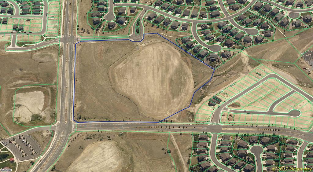
2 Plum Creek Parkway S Lake Gulch Road Plum Creek S Perry Street EmeraldDrive 25 Plum Creek Boulevard Crystal Valley Parkway Subject Property Crystal Vallley Ranch E Loop Road W Loop Road PRE CVR PA ,000 2,000 Feet F
3

4
5
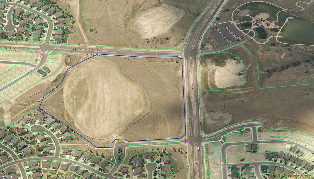
6 CRYSTAL VALLEY RANCH PARCEL AREA 7 Preliminary Project Application February 14, LOCATION The site is located in the a portion of the South half of Section 24, T8 South, R 67 West of the 6 th PM, Town of Castle Rock, State of Colorado. The site is bound to the west by Loop Road West, the west by CVR Filing No. 2, to the north by Crystal Valley Parkway, and to the South by Open Space dedicated with CVR Filing No PROPOSAL a. Change PA7 commercial area from 10 to 4 acres. b. Change PA7 residential area from 10 acres to 16 acres c. Set aside approximately 1.4 acres of open space surrounding residential area. d. Existing Zoning ; 171 units; max du/ac = 16.0 du/ac. No change proposed. 3. VEGETATION A little over half the site has been recently graded as a borrow site for CVR Filing 17. The remainder is almost entirely covered by native grasses. 4. WILDLIFE The variety of wildlife that inhabits an area is directly related to the amount, type and variety of vegetation present in the area. Each species of wildlife has certain requirements for water, ground cover, food source, and territory. If an area provides the right combination of these special parameters it is considered prime habitat for the type of wildlife that is adapted to it. This site is located in an area with surrounding development with a primary road corridor to the north and west. The wildlife will continue to visit the site giving the connective and continuous open space corridors within Crystal Valley Ranch. The most significant areas for wildlife are north of Crystal D:\legacy\CVR\PA7\CVRPA7 PPA Narrative.docx 1 of 2

7 Valley Parkway where there is a significant area of open space along the bluff. Once developed, the open space adjacent to the site on the west and south will provide cover for rodents, snakes, birds, and small mammals normal to this area of Castle Rock. No known nationally-designated threatened or endangered species have been observed or are known to exist within the property boundary. 5. GEOLOGY. SOILS AND NATURAL FEATURES This site contains three distinct soil and subsoil conditions. The development area was addressed in the a Custom Soil Resource Report by United States Department of Agriculture, Natural Resources Conservation Service dated February 3 rd, The general soil classifications are noted in the accompanying report.. The report states that in general, that the FU-Fondis-Kutch association soils are generally located south 30% of the site, well drained with a typical profile of Loam, Clay and Sandy clay loam and the north 70% of the site is covered by KtE profile. The KtE soils are generally located on 5 to 20 percent slopes. They are well drained and composed of Sandy loam from 0-6 inches, Clay at 6 to 32 inches and weathered bedrock at 32 to 36 inches in depth. 6. SKYLINE/RIDGELINE No portion of the site is located within identified Skyline or Ridgelines. 7. CONSIDERATIONS & QUESTIONS The primary purpose of this PPA is to create a massing study for demonstration of the adequacy of 4 acres of commercial ground on PA7. Four separate commercial layouts are provided to accomplish this goal. A road layout within the remaining resident area is provided to demonstrate the feasibility and integration of the commercial ground with residential use. The points of entry are very fixed on this site therefore feedback is sought on the basic compatibility of the sketch plan. The next step would be to submit a PD amendment to change the notation of 10.7 ac to be dedicated as residential (), 10.7 ac. to be dedicated as commercial to 16 ac to be dedicated as residential (R-MF- 24), 4 ac. to be dedicated as commercial, and 1.4 ac. to be dedicated as open space on the PD. D:\legacy\CVR\PA7\CVRPA7 PPA Narrative.docx 2 of 2
8 +/ acres (includes ROW) +/- 1.5 acres COMMERCIAL/BUSINESS PARCEL A +/ PARCEL B +/-.25 PARCEL C +/-.84 PARCEL D +/-.60 PARCEL E +/-.64 TOTAL: +/- 4.0 acres BUILDING FOOTPRINT USE SUMMARY PARCEL A: COMMERCIAL/OFFICE/ RETAIL/RESTAURANT 11,900 sf PARCEL B: OFFICE/RETAIL/SERVICES 1,800 sf PARCEL C: COMMERCIAL/OFFICE/ BUSINESS SERVICE 4,800 sf PARCEL D: RESTAURANT- WITH-DRIVE THRU 2,600 sf PARCEL E: RESTAURANT/OFFICE BUSINESS SERVICE/ RETAIL 1,450 sf TOTAL ALL BLDG: 22,500 sf 45' RIGHT OF WAY (TYPICAL RES.) 72' RIGHT OF WAY AT ENTRANCES OF IDYLWILD AND LOOP ROAD 4
9 +/ acres (includes ROW) +/- 1.5 acres COMMERCIAL/BUSINESS PARCEL A +/ PARCEL B +/-.25 PARCEL C +/-.84 PARCEL D +/-.60 PARCEL E +/-.64 TOTAL: +/- 4.0 acres BUILDING FOOTPRINT USE SUMMARY PARCEL A: COMMERCIAL/OFFICE/ INSTITUTION/MEDICAL 21,600 sf PARCEL B: AUTOMOTIVE SERVICE/ FUEL STATION/RETAIL 2,000 sf TOTAL ALL BLDG: 23,600 sf 45' RIGHT OF WAY (TYPICAL RES.) 72' RIGHT OF WAY AT ENTRANCES OF IDYLWILD AND LOOP ROAD 4
10 +/ acres (includes ROW) +/- 1.5 acres COMMERCIAL/BUSINESS PARCEL A +/ PARCEL B +/-.25 PARCEL C +/-.84 PARCEL D +/-.60 PARCEL E +/-.64 TOTAL: +/- 4.0 acres BUILDING FOOTPRINT USE SUMMARY PARCEL A: COMMERCIAL/OFFICE INSTITUTIONAL/MEDICAL 13,600 sf PARCEL B: COMMERCIAL/OFFICE/ INSTITUTIONAL/MEDICAL 10,125 sf TOTAL ALL BLDG: 23,600 sf 45' RIGHT OF WAY (TYPICAL RES.) 72' RIGHT OF WAY AT ENTRANCES OF IDYLWILD AND LOOP ROAD 4

11 +/ acres (includes ROW) +/- 1.5 acres COMMERCIAL/BUSINESS PARCEL A +/ PARCEL B +/-.25 PARCEL C +/-.84 PARCEL D +/-.60 PARCEL E +/-.64 TOTAL: +/- 4.0 acres BUILDING FOOTPRINT USE SUMMARY PARCEL A: COMMERCIAL/OFFICE RETAIL/RESTAURANT 12,675 sf PARCEL B: AUTOMOTIVE SERVICE/ FUEL STATION/RETAIL 2,300 sf PARCEL C: DAY CARE CENTER/ PRE SCHOOL 5,025 sf TOTAL ALL BLDG: 20,000 sf *FUEL CANOPY OF 4,800 sf NOT IN sf TOTAL 45' RIGHT OF WAY 45' RIGHT OF WAY (TYPICAL RES.) 72' RIGHT OF WAY AT ENTRANCES OF IDYLWILD AND LOOP ROAD 4 4
Letter of Intent May 2017 (Revised November 2017)
") THE BEACH AT WOODMOOR LETTER OF INTENT MAY 2017 (REVISED NOVEMBER 2017) OWNER/APPLICANT: CONSULTANT: Lake Woodmoor Holdings LLC N.E.S. Inc. 1755 Telstar Drive, Suite 211 619 North Cascade Avenue Colorado
THE BEACH AT WOODMOOR LETTER OF INTENT MAY 2017 (REVISED NOVEMBER 2017) OWNER/APPLICANT: CONSULTANT: Lake Woodmoor Holdings LLC N.E.S. Inc. 1755 Telstar Drive, Suite 211 619 North Cascade Avenue Colorado
Public Hearing. Item # 16. Meeting Date: June 3, 2014
 Item # 16 Meeting Date: June 3, 2014 Public Hearing Ordinance No. 2014-18: An Ordinance Amending the Town s Zone District Map by Approving the Plum Creek Ridge Planned Development Plan Amendment No. 1
River Rock Estates Sketch Plan, a proposed major subdivision in S24, T35N R2W NMPM on County Rd 119 (PLN18-336)
") MEMORANDUM Archuleta County Development Services Planning Department 1122 HWY 84 P. O. Box 1507 Pagosa Springs, Colorado 81147 970-264-1390 Fax 970-264-3338 TO: Archuleta County Planning Commission FROM:
MEMORANDUM Archuleta County Development Services Planning Department 1122 HWY 84 P. O. Box 1507 Pagosa Springs, Colorado 81147 970-264-1390 Fax 970-264-3338 TO: Archuleta County Planning Commission FROM:
June 23, 2009 Initial Meeting RURAL FRAMEWORK COMMITEE
 June 23, 2009 Initial Meeting RURAL FRAMEWORK COMMITEE Committee Member Introductions One minute summary Name Subarea location/stakeholder identification What do you hope will come out of this rural framework
ARTICLE FIVE FINAL DRAFT
 ARTICLE FIVE 021218 FINAL DRAFT Sec. 503.6 Open Space Preservation Option Open Space Preservation Option Open Space Preservation developments may be approved in the AR, R-1, R-2 and R-3 zoning districts,
Canyons South. Annexation Impact Report. September 1, 2015
 Canyons South Annexation Impact Report September 1, 2015 1 Introduction This Annexation Impact Report has been prepared to meet the statutory requirements set forth in Colorado Revised Statutes 31 12 108.5
APPLICATION PROCESSING. CHECK WITH STAFF - Development Services Staff will explain the requirements and procedures to you.
 PLANNED DEVELOPMENT ZONE 1810 E. HAZELTON AVENUE, STOCKTON CA 95205 BUSINESS PHONE: (209) 468-3121 Business Hours: 8:00 a.m. to 5:00 p.m. (Monday through Friday) STEP 1 STEP 2 FEE FORM DEED SERVICES APPLICATION
ZONING AMENDMENT, PLANNED UNIT DEVELOPMENT & SUBDIVISION STAFF REPORT Date: August 8, 2013
 ZONING AMENDMENT, PLANNED UNIT DEVELOPMENT & SUBDIVISION STAFF REPORT Date: August 8, 2013 NAME SUBDIVISION NAME PV-Magnolia, LLC Twelve Trees Subdivision LOCATION 2860, 2862 and 2866 Pleasant Valley Road
DRAFT FOR PUBLIC HEARING (rev. March, 2016)
") Chapter 200. ZONING Article VI. Conservation/Cluster Subdivisions 200-45. Intent and Purpose These provisions are intended to: A. Guide the future growth and development of the community consistent with
Chapter 200. ZONING Article VI. Conservation/Cluster Subdivisions 200-45. Intent and Purpose These provisions are intended to: A. Guide the future growth and development of the community consistent with
SKETCH PLAN TOWN OF GYPSUM (Revised 12/29/2015)
") SKETCH PLAN TOWN OF GYPSUM (Revised 12/29/2015) Lana Gallegos, Senior Planner 970-524-1729 Cindy Schwartz, Assistant Planner 970-524-1750 DATE APPLICATION SUBMITTED: NAME OF SUBDIVISION: _ NAME OF OWNER:
SKETCH PLAN TOWN OF GYPSUM (Revised 12/29/2015) Lana Gallegos, Senior Planner 970-524-1729 Cindy Schwartz, Assistant Planner 970-524-1750 DATE APPLICATION SUBMITTED: NAME OF SUBDIVISION: _ NAME OF OWNER:
Chapter Planned Residential Development Overlay
 Chapter 19.29 Planned Residential Development Overlay Sections 010 Purpose 020 Scope 030 Definitions 030 Minimum Size 040 Allowable Uses 050 Minimum Development Standards 060 Density Bonus 070 Open Space
TOWNSHIP OF EGG HARBOR ZONING BOARD ADJUSTMENT CHECK LIST
 TOWNSHIP OF EGG HARBOR ZONING BOARD ADJUSTMENT CHECK LIST Schedule A - General Requirements 1. Where the application involves only a variance one (1) original and nineteen (19) copies of the appropriate
TOWN OF ORO VALLEY PLANNING & ZONING COMMISSION MEETING DATE: December 6, 2011
 PLANNING & ZONING COMMISSION MEETING DATE: December 6, 2011 TO: FROM: SUBJECT: PLANNING & ZONING COMMISSION Matt Michels, Senior Planner mmichels@orovalleyaz.gov; tel. 229-4822 Public Hearing: Rancho de
Exhibit A-1. Piney Creek Bend Planned Development
 Exhibit A-1 Piney Creek Bend Planned Development A. Purpose and Intent The Piney Creek Bend PD is composed of approximately 90.91 acres, as described in Exhibit D (Field Notes). The development of this
USE BY SPECIAL REVIEW STAFF REPORT- UPDATE
 ~~DOUGLAS COl-U~!X www.douglas.co.us Department of Community Development Planning Services USE BY SPECIAL REVIEW STAFF REPORT- UPDATE December 2, 2014 TO: FROM: RE: Douglas County Planning Commission Pam
FINAL DRAFT 10/23/06 ARTICLE VI
 FINAL DRAFT 10/23/06 ARTICLE VI 185-41.1. Planned Residential Development A. Purpose and Intent. The purposes of the Planned Residential Development (PRD) bylaw are to maintain the rural character of Dover,
51.08 Acres AREA INFORMATION & CONCEPTUAL SITE PLAN
 Property Details: Folio #: R22-423-18-0000-0010-0000 Zoned: PDP (Planned Development Project Industrial) Lot Size: *Seller Willing to Allow Use Change* Direct Frontage on Anderson Snow Road 1.2 miles from
SKETCH PLAN REVIEW SPECIAL EXCEPTION, SPECIAL REVIEW,
 www.larimer.org Planning Department 200 W. Oak Street 3 rd Floor Fort Collins, CO 80521 970-498-7683 SKETCH PLAN REVIEW SKETCH PLAN REVIEW for Conservation Developments, Planned Land Divisions, Subdivisions,
CHAPTER 3 PRELIMINARY PLAT
 10-3-1 10-3-3 SECTION: CHAPTER 3 PRELIMINARY PLAT 10-3-1: Consultation 10-3-2: Filing 10-3-3: Requirements 10-3-4: Approval 10-3-5: Time Limitation 10-3-6: Grading Limitation 10-3-1: CONSULTATION: Each
SECTION 16. "PUD" PLANNED UNIT DEVELOPMENT OVERLAY DISTRICT
 SECTION 6. "PUD" PLANNED UNIT DEVELOPMENT OVERLAY DISTRICT Subsection. Purpose. This district is established to achieve the coordinated integration of land parcels and large commercial and retail establishments
STAFF REPORT FOR MAJOR SUBDIVISION
 STAFF REPORT FOR MAJOR SUBDIVISION FINAL PLAT CASE NO. FA-13-001 HEARING DATE: November 6, 2013 CASE NAME: Solterra Subdivision Filing No. 14 PROCEDURE: Planning Commission ADDRESS OF MAJOR SUBDIVISION
OPEN SPACE RESIDENTIAL DEVELOPMENT (OSRD) MODEL SITE PLAN BYLAW
 MODEL SITE PLAN BYLAW") OPEN SPACE RESIDENTIAL DEVELOPMENT (OSRD) MODEL SITE PLAN BYLAW 1) PURPOSE AND INTENT a) The Primary Purposes for OSRD are the following: i) To allow for greater flexibility and creativity in the design
OPEN SPACE RESIDENTIAL DEVELOPMENT (OSRD) MODEL SITE PLAN BYLAW 1) PURPOSE AND INTENT a) The Primary Purposes for OSRD are the following: i) To allow for greater flexibility and creativity in the design
Stroh Ranch Apartment Sites
 Stroh Ranch Apartment Sites J. Morgan Blvd & Ironstone Way Parker, CO 80134 Price: $4,200,000 Size: 11.05 Acres Units: 204 Zoned: Multi-Family Jurisdiction: Town of Parker Water & San: Parker Water & San
Preliminary Subdivision Application (Major) (Four (4) lots or more)
 (Four (4) lots or more)") Gunnison City Offices www.gunnisoncity.org 38 West Center Gunnison, Utah 84634 (435) 528 7969 Date of Application: Preliminary Subdivision Application (Major) (Four (4) lots or more) APPLICANT INFORMATION
Gunnison City Offices www.gunnisoncity.org 38 West Center Gunnison, Utah 84634 (435) 528 7969 Date of Application: Preliminary Subdivision Application (Major) (Four (4) lots or more) APPLICANT INFORMATION
SITE PLAN REVIEW ADMINISTRATIVE REVIEW. Please Note: Once submitted to the County, all application materials become a matter of public record.
 200 W. Oak Street, 3rd Floor Fort Collins, CO 80521 (970) 498-7683 / larimer.org/planning SITE PLAN REVIEW ADMINISTRATIVE REVIEW The submittal requirements listed in this packet are intended to collect
SUBJECT PARCEL(S) Property Owner(s) TMS Number Approximate Acreage Carolina Park Development, LLC
 Property Owner(s) TMS Number Approximate Acreage Carolina Park Development, LLC") Staff Report Special Planning Commission Meeting November 19, 2014 For reference, the Zoning Code and Land Development Regulations are available online. AGENDA ITEM 5c. SKETCH PLAN APPROVAL REQUEST: Request
Staff Report Special Planning Commission Meeting November 19, 2014 For reference, the Zoning Code and Land Development Regulations are available online. AGENDA ITEM 5c. SKETCH PLAN APPROVAL REQUEST: Request
Planned Unit Development (PUD). Sections:
. Sections:") Chapter 19.07. Planned Unit Development (PUD). Sections: 19.07.01. Purpose. 19.07.02. PUD Definition and Design Compatibility. 19.07.03. General PUD Standards. 19.07.04. Underlying Zones. 19.07.05. Permitted
Chapter 19.07. Planned Unit Development (PUD). Sections: 19.07.01. Purpose. 19.07.02. PUD Definition and Design Compatibility. 19.07.03. General PUD Standards. 19.07.04. Underlying Zones. 19.07.05. Permitted
Concept Plan Project Narrative For 852 River Ranch Court
 Concept Plan Project Narrative For 852 River Ranch Court Date: January 5, 2016 Prepared by: Robert W. Jones II, P.E. Vortex Engineering, Inc. 2394 Patterson Rd., Ste 201 Grand Junction, CO 81505 970-245-9051
GWINNETT COUNTY CSO CONSERVATION SUBDIVISION OVERLAY DISTRICT REQUIREMENTS
 GWINNETT COUNTY CSO CONSERVATION SUBDIVISION OVERLAY DISTRICT REQUIREMENTS Section 1316. CSO Conservation Subdivision Overlay District. 1. Purposes. The purposes of this overlay district are as follows:
ARTICLE 67. PD 67. Unless otherwise stated, the definitions and interpretations in Chapter 51 apply to this
 ARTICLE 67. PD 67. SEC. 51P-67.101. LEGISLATIVE HISTORY. PD 67 was established by Ordinance No. 15189, passed by the Dallas City Council on May 24, 1976. Ordinance No. 15189 amended Ordinance No. 10962,
CITY COUNCIL STUDY SESSION MEMORANDUM
 City and County of Broomfield, Colorado To: From: Prepared by: Owner Applicant Property Size Property Location: CITY COUNCIL STUDY SESSION MEMORANDUM Mayor and City Council Charles Ozaki, City and County
PINE CANYON PD ZONING REGULATIONS
 Review Notes: Green highlight = blanks to be completed before recording. 1. DEFINITIONS For purposes of the PD Plan and these Zoning Regulations: (1) capitalized terms used but not defined in the PD Plan
ARTICLE 12 PLANNED UNIT DEVELOPMENT DISTRICTS (PUDS) Sec Intent CHARTER TOWNSHIP OF BRIGHTON ZONING ORDINANCE
 Sec Intent CHARTER TOWNSHIP OF BRIGHTON ZONING ORDINANCE") ARTICLE 12 PLANNED UNIT DEVELOPMENT DISTRICTS (PUDS) Sec. 12-01 Intent 1 2 (a) The intent of this Article is to permit the coordinated development on larger sites, protect significant natural features
ARTICLE 12 PLANNED UNIT DEVELOPMENT DISTRICTS (PUDS) Sec. 12-01 Intent 1 2 (a) The intent of this Article is to permit the coordinated development on larger sites, protect significant natural features
City of Eustis Development Application
 City of Eustis Development Application File #: Date: Office Use Only Date: Property Alternate Key #(s) Parcel ID No: Legal Description: Application Type: Administrative Site Plan Final Plat Preliminary
ATHERTON PLACE CITY COUNCIL HEARING DECEMBER 5, 2017
 ATHERTON PLACE CITY COUNCIL HEARING DECEMBER 5, 2017 REQUESTED ACTION ATHERTON PLACE CONDUCT PUBLIC HEARING TO CONSIDER AND APPROVE: 1. MITIGATED NEGATIVE DECLARATION CALIFORNIA ENVIRONMENTAL QUALITY ACT
APPLICANT NAME SUBDIVISION NAME DEVELOPMENT NAME LOCATION. CITY COUNCIL DISTRICT Council District 4 PRESENT ZONING PROPOSED ZONING
 SUBDIVISION, PLANNED UNIT DEVELOPMENT, PLANNING APPROVAL, ZONING AMENDMENT, & SIDEWALK WAIVER REQUEST STAFF REPORT Date: February 17, 2010 APPLICANT NAME SUBDIVISION NAME DEVELOPMENT NAME LOCATION David
AGENDA STATEMENT NO BUSINESS OF THE PLANNING COMMISSION City of Victoria, Minnesota STAFF REPORT. Casco Ventures (Developer)
") AGENDA STATEMENT NO. 17-1 BUSINESS OF THE PLANNING COMMISSION City of Victoria, Minnesota STAFF REPORT TO: Planning Commission PREPARED BY: Erin Smith, Senior Planner RE: Waterford Landing Project Rezoning
AGENDA STATEMENT NO. 17-1 BUSINESS OF THE PLANNING COMMISSION City of Victoria, Minnesota STAFF REPORT TO: Planning Commission PREPARED BY: Erin Smith, Senior Planner RE: Waterford Landing Project Rezoning
FINAL PLAT SUBMITTAL CHECKLIST
 FINAL PLAT SUBMITTAL CHECKLIST The submission requirements for a Final Plat Review are found beginning in Section 24-4-40 of the Weld County Code. The Weld County Code is available on line at www.co.weld.co.us
Planning Commission Staff Report Final Plat Approval Administrative Hearing Date: June 5, 2013 ITEM 5 Dixon Neighborhood ALTERNATIVE ACTIONS
 Planning Commission Staff Report Final Plat Approval Adminis strative Hearing Date: June 5, 2013 ITEM 5 Doug Carlson, agent for Provo City Housing, requests final plat approval for the PCHA-1, Plat `C`,
PUD SKETCH PLAN APPLICATION
 PUD SKETCH PLAN APPLICATION ( Revised 2 / 17 /201 7 ) Lana Gallegos, Senior Planner 970-524-1729 Cindy Schwartz, Assistant Planner 970-524-1750 DATE APPLICATION SUBMITTED: 8/02/2017 NAME OF SUBDIVISION:
REZONING APPLICATION INSTRUCTIONS
 REZONING APPLICATION INSTRUCTIONS All required information, as stated on the Rezoning Application Checklist, must be included to qualify as a complete application. Upon receipt, staff will review the application
City of Fairfax, Virginia City Council Work Session
 City Council Work Session Agenda Item # City Council Meeting 5a 10/7/2014 TO: FROM: SUBJECT: Honorable Mayor and Members of City Council Robert Sisson, City Manager Discussion of a request by The IDI Group
Preliminary Subdivision Application (Minor) (Three (3) lots or less)
 (Three (3) lots or less)") Gunnison City Offices www.gunnisoncity.org 38 West Center Gunnison, Utah 84634 (435) 528 7969 Date of Application: Preliminary Subdivision Application (Minor) (Three (3) lots or less) APPLICANT INFORMATION
Gunnison City Offices www.gunnisoncity.org 38 West Center Gunnison, Utah 84634 (435) 528 7969 Date of Application: Preliminary Subdivision Application (Minor) (Three (3) lots or less) APPLICANT INFORMATION
Land Use. Existing Land Use
 8 Land Use 8.1 Land Use Chapter Purpose and Contents This element includes a brief summary of existing land use conditions and trends followed by a series of goals, objectives, and recommendations to guide
(if more than one, give square footage for each) ANNEXATION LOT LINE Adjustments PRE/FINAL PLAT SPECIAL USE PERMIT
 ANNEXATION LOT LINE Adjustments PRE/FINAL PLAT SPECIAL USE PERMIT") Planning Commission Application Building & development office 915 Third ST. Rawlins WY ph. 307-328-4599 fax. 307-328-4590 PROJECT REVIEW: GENERAL INFORMATION Project name: OFFICE USE ONLY Site address
Planning Commission Application Building & development office 915 Third ST. Rawlins WY ph. 307-328-4599 fax. 307-328-4590 PROJECT REVIEW: GENERAL INFORMATION Project name: OFFICE USE ONLY Site address
SECTION 4: PRELIMINARY PLAT
 SECTION 4: PRELIMINARY PLAT After the completion of the sketch plan process, if submitted, the owner or developer shall file with the City an application for preliminary plat. The preliminary plat stage
A. Preserve natural resources as identified in the Comprehensive Plan.
 1370.08 Conservation Residential Overlay District. Subd. 1 Findings. The City finds that the lands and resources within the Conservation Residential Overlay District are a unique and valuable resource
For Office Use Only. Permit No. Fee: $ $ per proposed lot (AN ADDITIONAL 10% CODE COMPLIANCE FEE WILL BE CHARGED)
") For Office Use Only Permit No. Fee: $1600 + $560.00 per proposed lot (AN ADDITIONAL 10% CODE COMPLIANCE FEE WILL BE CHARGED) LAND PARTITION FOREST (Conditional Use) Crook County Planning Department 300
For Office Use Only Permit No. Fee: $1600 + $560.00 per proposed lot (AN ADDITIONAL 10% CODE COMPLIANCE FEE WILL BE CHARGED) LAND PARTITION FOREST (Conditional Use) Crook County Planning Department 300
Town of Shelburne, Vermont
 Town of Shelburne, Vermont CHARTERED 1763 P.O. BOX 88 5420 SHELBURNE ROAD SHELBURNE, VT 05482 www.shelburnevt.org 802-985-5118 * * Also available in alternate formats in accordance with the Americans With
PLANNING COMMISSION STAFF REPORT
 PLANNING COMMISSION STAFF REPORT REZONING CASE: RZ-16-001 REPORT DATE: March 8, 2016 CASE NAME: Trailbreak Partners Rezoning PLANNING COMMISSION DATE: March 16, 2016 ADDRESSES OF REZONING PROPOSAL: 5501
ZONING AMENDMENT & SUBDIVISION STAFF REPORT Date: July 3, 2014
 ZONING AMENDMENT & SUBDIVISION STAFF REPORT Date: July 3, 2014 APPLICANT NAME SUBDIVISION NAME LOCATION Georgia Crown Distributing Subdivision Georgia Crown Distributing Subdivision Southwest corner of
ARTICLE SINGLE FAMILY SITE CONDOMINIUM DEVELOPMENT STANDARDS
 ARTICLE 28.00 SINGLE FAMILY SITE CONDOMINIUM DEVELOPMENT STANDARDS Section 28.01 PURPOSE The purpose of this Article is to recognize that conventional single family developments, traditionally developed
Minor Replat Celebration Pointe Peterson Road TECHNICAL REVIEW PROJECT: #
 March 15, 2018 Tony Huerta 3501 Industrial 29 th Street Fort Pierce, FL 34946 SUBJECT: Comments: Minor Replat Celebration Pointe - 5501 Peterson Road TECHNICAL REVIEW PROJECT: # 18-05000001 1. The plan
Article 3 - Rural Districts
 rticle 3 - Rural Districts Div. 3.1. -40: griculture 40 (OI Only) 3-2 3.1.1. Intent... 3-2 3.1.2. Lot Dimensions... 3-2 3.1.3. uilding Placement... 3-3 3.1.4. uilding Height... 3-3 Div. 3.2. -20: griculture
Biodiversity Planning Policy and Guidelines for (LEP) Rezoning Proposals
 Rezoning Proposals") Council Policy Biodiversity Planning Policy and Guidelines for (LEP) Rezoning Proposals Table of Contents Table of Contents... 1 Policy... 2 Policy Objectives... 2 Policy Statement... 2 Guidelines... 2
Council Policy Biodiversity Planning Policy and Guidelines for (LEP) Rezoning Proposals Table of Contents Table of Contents... 1 Policy... 2 Policy Objectives... 2 Policy Statement... 2 Guidelines... 2
Article Optional Method Requirements
 Article 59-6. Optional Method Requirements [DIV. 6.1. MPDU DEVELOPMENT IN RURAL RESIDENTIAL AND RESIDENTIAL ZONES Sec. 6.1.1. General Requirements... 6 2 Sec. 6.1.2. General Site and Building Type Mix...
Affordable Housing Plan
 Affordable Housing Plan CORDOVA HILLS SPECIAL PLANNING AREA 1 Proposed Project Conwy LLC is the master developer ( Master Developer ) of that certain real property in the County of Sacramento ( County
City of Sanibel. Planning Department STAFF REPORT
 City of Sanibel Planning Department STAFF REPORT Planning Commission Meeting: July 23, 2013 Planning Commission Agenda Item: No 7b. Application Number: 13-7438DP Applicant Name: Attorney Beverly Grady
DOUGLAS COUNTY SUBDIVISION RESOLUTION Article 4 Preliminary Plan 10/13/2015
 ARTICLE 4 PRELIMINARY PLAN 401 Intent An in-depth analysis of the proposed subdivision, including a review of the design considering the ability to obtain water and sanitation, identified geologic hazards,
SUBDIVISION, PLANNED UNIT DEVELOPMENT, PLANNING APPROVAL, ZONING AMENDMENT, & SIDEWALK WAIVER REQUEST STAFF REPORT Date: February 17, 2010
 SUBDIVISION, PLANNED UNIT DEVELOPMENT, PLANNING APPROVAL, ZONING AMENDMENT, & SIDEWALK WAIVER REQUEST STAFF REPORT Date: February 17, 2010 APPLICANT NAME SUBDIVISION NAME DEVELOPMENT NAME LOCATION David
SECTION 5: ACCESSORY USES
 SECTION 5: ACCESSORY USES A. In Any District Subject to the restrictions of the Zoning Resolution, a use, equipment or item customarily incidental to an existing permitted use on a lot shall also be permitted
Application Procedure for Change of Zoning City of Livonia, Michigan
 Application Procedure for Change of Zoning City of Livonia, Michigan Section 23.02 Procedure for Amendment Applications. Where an application is presented by a property owner or owners, pursuant to Section
ARTICLE 8A RPUD RESIDENTIAL PLANNED UNIT DEVELOPMENT
 ARTICLE 8A RPUD RESIDENTIAL PLANNED UNIT DEVELOPMENT SECTION 8A.01 PURPOSE The Residential Planned Unit Development (RPUD) is an optional development provision which provides a list of "overlay" zoning
Plat/Site Plan Application
 Instructions Plat/Site Plan Application For your application to be officially accepted for processing, you must complete this application in full. The owner/agent certification must be signed and notarized
NEIGHBORHOOD MEETING
 NEIGHBORHOOD MEETING Community Development Department 8101 Ralston Road Arvada, Colorado 80002 NEIGHBORHOOD MEETINGS The City of Arvada promotes citizen participation in the development review process.
ARTICLE 15 - PLANNED UNIT DEVELOPMENT
 Section 15.1 - Intent. ARTICLE 15 - PLANNED UNIT DEVELOPMENT A PUD, or Planned Unit Development, is not a District per se, but rather a set of standards that may be applied to a development type. The Planned
Cluster Development Princeton Township, Mercer County
 Cluster Development Princeton Township, Mercer County Division 9 Residential Clusters Section 10B-189 Statement of purposes. The township committee to implement the goals and objectives of the Princeton
STAFF REPORT FOR MAJOR SUBDIVISION
 STAFF REPORT FOR MAJOR SUBDIVISION FINAL PLAT CASE NO. FA-14-001 HEARING DATE: January 6, 2016 CASE NAME: Solterra Subdivision Filing No. 16 PROCEDURE: Planning Commission ADDRESS OF MAJOR SUBDIVISION
4 August 13, 2014 Public Hearing
 4 August 13, 2014 Public Hearing APPLICANT & PROPERTY OWNER: LILLEL FARMS, INC. STAFF PLANNER: Kristine Gay REQUEST: Change of Zoning (Conditional PDH-2 with A-24 Apartment Zoning District to P-1 Preservation
CITY OF OCOEE LAND DEVELOPMENT CODE SUFFICIENCY TABLE WITH NOTES
 CITY OF OCOEE LAND DEVELOPMENT CODE SUFFICIENCY TABLE WITH NOTES The Sufficiency Table is a checklist to help identify the types of information and documentation needed for various types of projects. The
TITLE 25. SUBDIVISIONS 1
 TITLE 25. SUBDIVISIONS 1 Sections: Chapter 25.01 General Provisions. Section 25.01.01 Short Title. Section 25.01.02 Purposes. Section 25.01.03 Final Plat Required Before Lots May be Sold. Section 25.01.04
Castle Rock, Colorado. PD Zoning Regulations July 19, 2000 Revised November 20, 2002 Revised June 10, 2013
 Lanterns Property Castle Rock, Colorado PD Zoning Regulations July 19, 2000 Revised November 20, 2002 Revised June 10, 2013 Prepared for: Prepared by: Castle Lantern, LLC NORRIS DESIGN 12460 1st St. 1101
LAND VALLEY FOR SALE. - in - RESIDENTIAL SUBDIVISION OPPORTUNITY SE McKinley Road, Gresham OR GRESHAM S PLEASANT SUBDIVISION OPPORTUNITY
 FOR SALE JENNE BUTTE PARK EXISTING HOMES S BORDER AY (SITE ACCE) LAND SUBDIVISION OPPORTUNITY - in - 15.26 AC GRESHAM S PLEASANT VALLEY 2839 S 2nd Avenue Portland OR, 97201 503.222.1655 www.reig.com 15.26
MAJOR SUBDIVISION REVIEW PROCEDURE Division of Land with Improvements
 Planning Services Department City Hall - 50 West 13 th Street Dubuque, IA 52001-4805 (563) 589-4210 phone (563) 589-4221 fax (563) 690-6678 TDD planning@cityofdubuque.org MAJOR SUBDIVISION REVIEW PROCEDURE
PUBLIC HEARING FM 2499 Section 4
 PUBLIC HEARIG FM 2499 Section 4 From FM 47 to FM 2181 October 4, 2 University of orth Texas Coliseum 6 orth Texas Boulevard Denton, Texas Tonight s Agenda Purpose of Tonight s Hearing Welcome & Introduction
WESTMINSTER PARK SUBDIVISION
 WESTMINSTER PARK SUBDIVISION Engineering Comments: FINAL PLAT COMMENTS (should be addressed prior to submitting the FINAL PLAT for review and/or signature by the City Engineer): A. Provide all of the required
BY BOARD OF COUNTY COMMISSIONERS AN ACT TO BE ENTITLED
 BY BOARD OF COUNTY COMMISSIONERS ORDINANCE NO. AN ACT TO BE ENTITLED AN ORDINANCE AMENDING THE PASCO COUNTY LAND DEVELOPMENT CODE, ARTICLE 700, BY REPEALING EXISTING SECTION 702, ENVIRONMENTALLY SENSITIVE
Marion County Board of County Commissioners
 Marion County Board of County Commissioners Date: 6/4/217 P&Z: 9/25/217 BCC Transmittal: 1/17/217 BCC Adopt: TBD Amendment No: 217-L6 Type of Application Large-Scale Comp Plan Amendment Request: Change
Appendix J - Planned Unit Development (PUD)
") Appendix J - Planned Unit Development (PUD) Intent and Purpose The purpose of the PUD is: 1. To provide development that is consistent with the Comprehensive Land Use Plan and promote the goals and objectives
Appendix J - Planned Unit Development (PUD) Intent and Purpose The purpose of the PUD is: 1. To provide development that is consistent with the Comprehensive Land Use Plan and promote the goals and objectives
Guide to Combined Preliminary and Final Plats
 Guide to Combined Preliminary and Final Plats Introduction The Douglas County is committed to providing open, transparent application processes to the public. This Guide is provided to assist anyone interested
Rural Municipality of Kellross No Official Community Plan. Bylaw No
 Rural Municipality of Kellross No. 247 Official Community Plan Bylaw No. 2009-03 2 BYLAW NO. 2009-03 THE RURAL MUNICIPALITY OF KELLROSS NO. 247 LEROSS, SASKATCHEWAN A Bylaw of the Rural Municipality of
PUD Zoning Plan Subdivision Sketch Plan & PUD Development Plan Subdivision Preliminary Plan. Application
 PUD Zoning Plan Subdivision Sketch Plan & PUD Development Plan Subdivision Preliminary Plan Application December 2013 Haymeadow Combined PUD Zoning Plan Subdivision Concept Plan & PUD Development Plan
Town Center South End Development Area District
 175.28 ESTABLISHMENT OF DISTRICTS. In order to carry out the purpose and intent of this chapter, the area of the is hereby divided into eighteen (18) Zoning District Classifications and one overlay zoning
City of Dade City, Florida Land Development Regulations ARTICLE 5: DENSITY, INTENSITY & DIMENSIONAL STANDARDS
 City of Dade City, Florida Land Development Regulations ARTICLE 5: DENSITY, INTENSITY & DIMENSIONAL STANDARDS ADOPTED AUGUST 12, 2014 ARTICLE 5: DENSITY, INTENSITY & DIMENSIONAL STANDARDS SECTION 5.1 DIMENSIONAL
THE AREA PLAN COMMISSION OF ST. JOSEPH COUNTY, IN AGENDA
 THE AREA PLAN COMMISSION OF ST. JOSEPH COUNTY, IN AGENDA Tuesday, June 20, 2017 Fourth-Floor Council Chambers 3:30 p.m. County-City Building, South Bend, IN PUBLIC HEARINGS: 1. Rezonings: A. A combined
50 Humberwood Boulevard - Zoning By-law Amendment Application - Preliminary Report
 STAFF REPORT ACTION REQUIRED 50 Humberwood Boulevard - Zoning By-law Amendment Application - Preliminary Report Date: September 14, 2015 To: From: Wards: Reference Number: Etobicoke York Community Council
Self-Guided Walking Tours Ground-oriented Housing Types. Cedar Cottage Tour Cambie Corridor Phase 3
 Self-Guided Walking Tours Ground-oriented Housing Types Cedar Cottage Tour Cambie Corridor Phase 3 City of Vancouver September 2015 Self-guided Walking Tours Ground-oriented Housing Types Take this self-guided
Natomas Joint Vision Open Space Program
 Natomas Joint Vision Open Space Program Fourth Workshop The City of Sacramento The County of Sacramento LAFCO February 19, 2008 Natomas Joint Vision MOU Basic Principles Open space preservation for habitat,
COUNTY OF LINCOLN, NORTH CAROLINA
 COUNTY OF LINCOLN, NORTH CAROLINA 302 NORTH ACADEMY STREET, SUITE A, LINCOLNTON, NORTH CAROLINA 28092 PLANNING AND INSPECTIONS DEPARTMENT 704-736-8440 OFFICE 704-732-9010 FAX To: George Wood County Manager
ARTICLE 7 UTILITIES AND EASEMENTS
 7.1 PLACEMENT OF UTILITIES ARTICLE 7 UTILITIES AND EASEMENTS 7.1.1 All authorized public underground utilities shall be located within the right-of-way of a public street or within an easement designated
Initial Subdivision Applications Shall Include the Following:
 Initial Subdivision Applications Shall Include the Following: 1) Subdivision Application Form: completely filled out (12 copies) 2) Plat: The Plat must adhere to the requirements set forth in the Town
FEE The staff will let you know the current cost of filing an application. Make checks payable to the San Joaquin County Treasurer.
 VARIANCE 1810 E. HAZELTON AVENUE, STOCKTON CA 95205 BUSINESS PHONE: (209) 468-3121 Business Hours: 8:00 a.m. to 5:00 p.m. (Monday through Friday) STEP 1 STEP 2 APPLICATION PROCESSING STEPS CHECK WITH STAFF
APPLICATION FOR SUBDIVISION APPROVAL OF A SKETCH PLAN with checklist
 Prior to filing any application for SUBDIVISION approval, the applicant shall request in writing that the zoning administrator schedule a pre-submission conference. APPLICATION TO THE PLANNING BOARD TOWN
CITY OF RIALTO PLANNING DIVISION ENTITLEMENT APPLICATION
 ENTITLEMENT APPLICATION LEGAL OWNER INFORMATION: I hereby certify that I am (we are) the record owner(s) for property tax assessment purposes of the property encompassed by this application. I understand
APPLICATION FOR APPROVAL OF A PLAN OF SUBDIVISION OR CONDOMINIUM DESCRIPTION Under Section 51 of the Planning Act
 APPLICATION FOR APPROVAL OF A PLAN OF SUBDIVISION OR CONDOMINIUM DESCRIPTION Under Section 51 of the Planning Act Name of Approval Authority: THE CORPORATION OF THE COUNTY OF RENFREW 9 International Drive,
DOUGLAS COUNTY ZONING RESOLUTION Section 4 LRR - Large Rural Residential District 3/10/99. -Section Contents-
 SECTION 4 LRR LARGE RURAL RESIDENTIAL DISTRICT -Section Contents- 401 Intent... 4-2 402 Principal Uses... 4-2 403 Accessory Uses... 4-3 404 Uses Permitted by Special Review... 4-4 405 Land Dedication...
APPLICATION FOR MINOR SUBDIVISION INSTRUCTION TO APPLICANTS
 Planning Services Division 3675 Mt. Diablo Boulevard, Suite 210 Lafayette, CA 94549 Tel. (925) 284-1976 Fax (925) 284-1122 http://www.ci.lafayette.ca.us APPLICATION FOR MINOR SUBDIVISION INSTRUCTION TO
4. facilitate the construction of streets, utilities and public services in a more economical and efficient manner;
 PVPC MODEL BYLAW BY-RIGHT CLUSTER ZONING BYLAW Prepared by Pioneer Valley Planning Commission Revised: October 2001 1.00 Development 1.01 Development Allowed By Right Development in accordance with this
PRELIMINARY STAFF PLANNING REPORT TO THE WALWORTH COUNTY ZONING AGENCY CONDITIONAL USE
 This report was prepared prior to the public hearing. This report may be supplemented or amended to reflect the review of additional information presented at the public hearing and written material submitted
Amendment to Subdistrict 6, the Davis Corridor, within Planned Development District No. 830
 Amendment to Subdistrict 6, the Davis Corridor, within Planned Development District No. 830 Community Meeting April 10, 2018 6:00 P.M. Tyler Street United Methodist Church 927 W. 10 th St, Dallas, TX 75208