Supplemental Feasibility Study for Ravenswood, Oak Grove, Glenwood and Encinal Avenues Grade Separation. for the. City of Menlo Park
|
|
|
- Avice Neal
- 6 years ago
- Views:
Transcription

1 Supplemental Feasibility Study for Ravenswood, Oak Grove, Glenwood and Encinal Avenues Grade Separation for the City of Menlo Park 1

2 2 Location Map SRI City Hall Alma El Camino Real Ravenswood Oak Grove Laurel Depot Glenwood Encinal RR Track Town Of Atherton Menlo College Study Locations


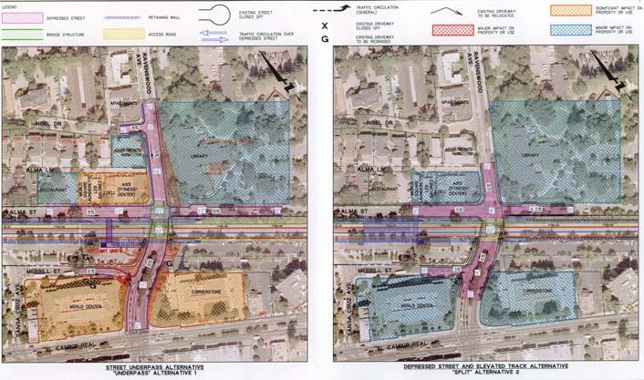
3 Ravenswood Avenue Alternate 1 Underpass Grade Separation Advantages: No raised embankment required Possibly less disruptive to community during construction Disadvantages: Greater impact on surrounding properties 3


4 Ravenswood Avenue Alternate 2 Split Grade Separation Advantages: Reduced impact on surrounding property Better vehicle circulation Better station layout Disadvantages: Raised embankment Possible more disruption during construction 4
5 5 Ravenswood Avenue


6 Alternate 1 Underpass Grade Separation Advantages: No track embankment required Disadvantages: 20 Deep narrow underpass required Oak Grove Avenue Access to property near tracks disrupted Could require modification of existing land use 6


7 Oak Grove Avenue Alternate 2 Split Grade Separation Advantages: Minimizes impact on existing land use Traffic patterns can be maintained Disadvantages: Requires raised track embankment Disruptions during construction 7

8 8 Oak Grove Avenue

9 9 Glenwood Avenue

10 10 Encinal Avenue

11 Existing Depot Oakgrove Ave Alma Street Ravenswood Ave. Merrill Street Depot Building Bus Shelter Model Railroad Building 11

12 DEPRESSED STREET (Underpass) Overall Station Plan Track expansion Building impacts Landscape impacts Parking impacts Station ex. to 89 prop. Alma St ex. to 50 prop. Pedestrian circulation Vehicular circulation 12
 Building")

13 DEPRESSED STREET (Underpass) Building Relocation Platform Limit Downtown Platform Limit 13
")

14 DEPRESSED STREET (Underpass) Building Relocation Platform Limit 14
 Existing")

15 DEPRESSED STREET (Underpass) Existing Grade 15 Pedestrian Underpass Alma Street Merrill Street


16 Lawrence Pedestrian Underpass Stair Access Underpass Handicap Ramp 16

17 DEPRESSED STREET (Underpass) Traffic Circulation Existing Grade 17

18 DEPRESSED STREET & ELEVATED TRACKS (Split) Overall Station Plan Track expansion Building impacts Landscape impacts Parking impacts Station ex. to 66 prop. Alma St ex. to 32 prop. Pedestrian circulation Vehicular circulation 18

19 DEPRESSED STREET & ELEVATED TRACKS (Split) Building Relocation Platform Limit Downtown 19


20 DEPRESSED STREET & ELEVATED TRACKS (Split) Overall Station Plan Platform Limit 20


21 San Carlos Station Concourse Area Planter & Handicap Access Planters in Concourse 21


22 DEPRESSED STREET & ELEVATED TRACKS (Split) Pedestrian Underpass Existing Grade 22
 Traffic Circulation Existing")
23 DEPRESSED STREET & ELEVATED TRACKS (Split) Traffic Circulation Existing Grade 23

24 COMPARISON Traffic Circulation Existing Grade UNDERPASS Existing Grade SPLIT 24
25 26 Construction Issues
26 Concept Plan Key Issues Construction Impacts Additional right of of way is is required Construction staging // sequencing Vehicular flow Pedestrian & bicycle movements Tree removal Impact on adjacent roadways Disruption of of the existing station 27

27 Shoofly & Raised Track R/W 85 R/W 60 0 R/W Existing Condition R/W 85 R/W 60 R/W Shoofly construction R/W 85 R/W 60 R/W Completion of Two tracks R/W 85 R/W Completion of Four tracks 28

28 ENCINAL AVENUE Northern Section of Tracks CITY LIMIT LINE TEMPORARY EASEMENT TEMPORARY EASEMENT PERMANENT EASEMENT DEPOT RELOCATED TEMPORARY EASEMENT ENCINAL AVENUE CITY LIMIT LINE TEMPORARY EASEMENT TEMPORARY EASEMENT DEPOT REMAINS IN CURRENT LOCATION 29

29 GLENWOOD AVE. Center Section of Tracks TEMPORARY EASEMENT TEMPORARY EASEMENT PERMANENT EASEMENT PERMANENT EASEMENT GLENWOOD AVE. PERMANENT EASEMENT DEPOT RELOCATED OAK GROVE AVE RAVENSWOOD TEMPORARY EASEMENT TEMPORARY EASEMENT DEPOT REMAINS IN CURRENT LOCATION RAVENSWOOD 30

30 Southern Section of Track PERMANENT EASEMENT TEMPORARY EASEMENT PERMANENT EASEMENT PERMANENT EASEMENT DEPOT RELOCATED TEMPORARY EASEMENT DEPOT REMAINS IN CURRENT LOCATION 31

31 32 Roadway Detour RAVENSWOOD ROAD DETOURS OAK GROVE AVE

32 Crossing Staging Phase 1 Construct detour road Phase 2 Construct bridge and embankment Phase 3 Reroute traffic to old crossing and fill in detour Phase 4 Lower roadway 33

33 Alma Street 45 FEET +/- 20 FEET +/- ALMA STREET LOOKING NORTH FROM RAVENSWOOD 34
PROJECT DESCRIPTION STATION 1300
 PROJECT DESCRIPTION STATION 1300 Introduction Several principles underpin Greenheart Land Company s design of Station 1300. Primary was to create a community resource: a place where people eat, shop, recreate,
Creative Approaches to Land Acquisition
 2007 Legislative Session Review CALIFORNIA TRANSIT ASSOCIATION JANUARY/FEBRUARY 2008 Creative Approaches to Land Acquisition Result From Creative Approaches to Land Acquisition It should not surprise anyone
R/W PREQUALIFICATION ODOT, 3/14/2018 PROPERTY MAP SHEET
 R/W PREQUALIFICATION ODOT, 3/14/2018 3A Title Block 3B Sheet Heading 3C Station Limit Flags 3D Revision Block 3E Ownership Name and Number 3F Centerline Stationing 3G Proposed R/W and Pavement 3H Structures
Community Development
 Community Development STAFF REPORT Housing Commission Meeting Date: 7/11/2018 Staff Report Number: 18-013-HC Regular Business: Review and provide feedback on potential amendments to the El Camino /Downtown
SECTION 7000 LAND DEVELOPMENT REQUIREMENTS
 SECTION 7000 LAND DEVELOPMENT REQUIREMENTS 7000 LAND DEVELOPMENT REQUIREMENTS... 1 7001 LEGISLATIVE AUTHORITY... 1 7001.1 LAND DEVELOPMENT... 1 7001.1.1 Title 40, Idaho Code... 1 7001.1.2 Idaho Code 40-1415
Subway station improvements in Downtown Brooklyn and in commercial zones of 10 FAR and above in Manhattan (6/28/04)
") Land Use Law Center Gaining Ground Information Database Topic: Resource Type: State: Jurisdiction Type: Municipality: Year (adopted, written, etc.): 2004 Community Type applicable to: Title: Document Last
Land Use Law Center Gaining Ground Information Database Topic: Resource Type: State: Jurisdiction Type: Municipality: Year (adopted, written, etc.): 2004 Community Type applicable to: Title: Document Last
The Scarborough Rapid Transit (SRT) Extension Study has expanded its scope and boundaries southerly to include a new multimodal facility at Kennedy
 Extension Study has expanded its scope and boundaries southerly to include a new multimodal facility at Kennedy") The Scarborough Rapid Transit (SRT) Extension Study has expanded its scope and boundaries southerly to include a new multimodal facility at Kennedy Station. The Transit Project Assessment (TPA) work for
The Scarborough Rapid Transit (SRT) Extension Study has expanded its scope and boundaries southerly to include a new multimodal facility at Kennedy Station. The Transit Project Assessment (TPA) work for
TRANSIT-ORIENTED DEVELOPMENT PLAN EXISTING CONDITIONS REPORT LAWRENCE TO BRYN MAWR MODERNIZATION
 TRANSIT-ORIENTED DEVELOPMENT PLAN EXISTING CONDITIONS REPORT LAWRENCE TO BRYN MAWR MODERNIZATION March 2018- FINAL DRAFT SITE SPECIFIC DEVELOPMENT CONCEPTS SITE SPECIFIC DEVELOPMENT CONCEPTS This report
CITRUS HEIGHTS COMMUNITY SPECIAL PLANNING AREA
 CITRUS HEIGHTS COMMUNITY SPECIAL PLANNING AREA 501-90. INTENT. It is the intent of the Board of Supervisors in adopting this Special Planning Area Ordinance to allow development on the property described
Encroachment Permit Instructions and Application
 Jeremy Robinson Commissioner Ann Fordock Martin E. Davis, L.S. DEPARTMENT OF PUBLIC WORKS Ben Walsh, Mayor Encroachment Permit Instructions and Application TERMS & CONDITIONS The public right-of-way, as
Project Description Preferred Alternative
 DETERMINATION AND FINDINGS PURSUANT TO SECTION 204 OF EMINENT DOMAIN PROCEDURE LAW (EDPL) CITY OF SYRACUSE, PROEJCT SPONSOR CREEKWALK PHASE II JEFFERSON STREET TO COLVIN STREET PROJECT IDENTIFICATION NO.
2.2 72ND STREET STATION ENTRANCE ALTERNATIVES
 Chapter 2: Entrance Alternatives 2.1 INTRODUCTION This chapter describes the alternatives that are evaluated in this Supplemental Environmental Assessment (EA) for the 72nd Street Station and 86th Street
5. Land Acquisition and Displacement
 Northern Branch Corridor SDEIS March 2017 5. Land Acquisition and Displacement 5.1. Chapter Overview 5.1.1. Introduction Implementation of the Preferred Alternative would require the acquisition of property
Fully Approved! Downtown Menlo Park REVITALIZED. ±55,000 Sq Ft Mixed-Use Development. Delivery Q TRANSIT - ORIENTED
 Fully Approved! TRANSIT - ORIENTED Downtown Menlo Park REVITALIZED ±55,000 Sq Ft Mixed-Use Development ±22,500 Sq Ft of Class A+ Office (Multiple Demising Options) Delivery Q4 2019 Christian Prelle 650.688.8504
AGENDA ITEM K3 Community Development
 AGENDA ITEM K3 Community Development STAFF REPORT City Council Meeting Date: 4/17/2018 Staff Report Number: 18-079-CC Regular Business: Complete the biennial review of the El Camino /Downtown Specific
Response to Community Questions Regarding Hunter College-68th Street ADA Project
 Response to Community Questions Regarding Hunter College-68th Street ADA Project 1. Has the MTA completed and/or published an Environmental Impact Statement or Environmental Assessment under NEPA (or the
Section 4 Master Plan Framework
 Section 4 Master Plan Framework 4.1 PURPOSE The Master Plan, as an implementation tool of the SPC District, establishes the primary framework for the overall development of the Property. Detailed site
REDEVELOPMENT PLAN FOR THE TRANSBAY REDEVELOPMENT PROJECT AREA
 REDEVELOPMENT PLAN FOR THE TRANSBAY REDEVELOPMENT PROJECT AREA Amended Redevelopment Plan Adopted and Approved by the Board of Supervisors of the City and County of San Francisco Ordinance No. 62-16, April
2.1 INTRODUCTION 2.2 BACKGROUND
 Chapter 2: Project Alternatives 2.1 INTRODUCTION Two alternatives are evaluated in the 68th Street/Hunter College Subway Station Improvement Project EA. This chapter describes the alternatives considered
IMPORTANT INFORMATION TRANSPORT CHANGES AND CONSTRUCTION WORKS, DOMAIN
 IMPORTANT INFORMATION TRANSPORT CHANGES AND CONSTRUCTION WORKS, DOMAIN Works in preparation for major construction of the Metro Tunnel are underway in Domain. New tram infrastructure will be built on and
353 W. Grand June 18, 2018
 353 W. Grand COMMUNITY MEETING June 18, 2018 Developer / Owner / CG : The Onni Group Architect of Record : Brininstool + Lynch Zoning Counsel : Taft Stettinius & Hollister LLP Traffic Consultant : Eriksson
M-43 CORRIDOR OVERLAY ZONE
 ARTICLE 26.00 M-43 CORRIDOR OVERLAY ZONE Section 26.01 Findings A primary function of the M-43 state highway is to move traffic through the Township and to points beyond. As the primary east-west arterial
CITY OF WEST PALM BEACH PLANNING BOARD Meeting Date: July 17, 2018 Planning Board Case No. 1670I
 CITY OF WEST PALM BEACH PLANNING BOARD Meeting Date: July 17, 2018 Planning Board Case No. 1670I Palms Gateway Commercial Planned Development (CPD) Southeast Corner of Belvedere Road and Australian Avenue
Draft Model Access Management Overlay Ordinance
 Draft Model Access Management Overlay Ordinance This model was developed using the City of Hutchinson and the Trunk Highway 7 corridor. The basic provisions of this model may be adopted by any jurisdiction
POTOMAC ELEMENTARY SCHOOL MODERNIZATION STUDY PTA PRESENTATION MAY 15, 2013
 Montgomery County Public Schools POTOMAC ELEMENTARY SCHOOL MODERNIZATION STUDY PTA PRESENTATION MAY 15, 2013 Jim Henderson, AIA, LEED BD+C Managing Principal Meeting Schedule Work Session #1 February 6,
DESIGN PUBLIC HEARING JANUARY 12, 2017 TOWN HALL SULLIVAN MEETING ROOM 558 SOUTH MAIN STREET RAYNHAM, MASSACHUSETTS 7:00 PM FOR THE PROPOSED
 DESIGN PUBLIC HEARING JANUARY 12, 2017 AT TOWN HALL SULLIVAN MEETING ROOM 558 SOUTH MAIN STREET RAYNHAM, MASSACHUSETTS 7:00 PM FOR THE PROPOSED REPLACEMENT OF BRIDGE NO. R-02-013 US ROUTE 44 OVER STATE
Multi-Family Residential
 2600 Frontview Crescent Completed: 2009 Project consisted of 31 Condominiums and nine luxury townhome residences with spectacular views of downtown Denver and within walking distance to Invesco Field.
DESIGN PUBLIC HEARING MAY 18, 2017 GROVELAND TOWN HALL GROVELAND, MASSACHUSETTS 7:00PM FOR THE PROPOSED
 DESIGN PUBLIC HEARING MAY 18, 2017 AT GROVELAND TOWN HALL GROVELAND, MASSACHUSETTS 7:00PM FOR THE PROPOSED GROVELAND COMMUNITY TRAIL PROJECT Roadway Project Management Section IN THE TOWN OF GROVELAND,
CITY PLANNING COMMISSION COMPREHENSIVE PLAN AND REVIEW CRITERIA
 Page 3 CITY PLANNING COMMISSION COMPREHENSIVE PLAN AND REVIEW CRITERIA COMPREHENSIVE PLAN: The City Planning Commission uses the Comprehensive Plan as a guide in all land use matters. The Plan is available
3.3 Acquisitions and Displacements/Relocations
 Chapter 3 Social Effects 3.3 Acquisitions and Displacements/Relocations This section discusses property displacements, relocations, and acquisitions (partial or full) that might occur due to implementation
Community Development
 Community Development STAFF REPORT Planning Commission Meeting Date: 7/17/2017 Staff Report Number: 17-047-PC Public Hearing: Use Permit/Alan Coon/989 El Camino Real Recommendation Staff recommends that
VTA s BART SILICON VALLEY PROGRAM Phase 1 Berryessa Extension Project
 VTA s BART SILICON VALLEY PROGRAM Phase 1 Berryessa Extension Project Addendum No. 6 to the 2 nd Supplemental Environmental Impact Report Santa Clara Valley Transportation Authority March 2015 1 Table
POLK COUNTY DEVELOPMENT REVIEW COMMITTEE CASE OVERVIEW
 POLK COUNTY DEVELOPMENT REVIEW COMMITTEE CASE OVERVIEW DRC Date: January 10, 2019 Level of Review: 4 PC Date: March 6, 2019 Type: Text Amendments BoCC Date: May 7, 2019 July 2, 2019 Case Numbers: Case
Be linked by an internal circulation system (i.e., walkways, streets, etc.) to other structures within the IPUD;
 to other structures within the IPUD;") 2. HALIFAX ACTIVITY CENTER A. DESCRIPTIONS OF FUTURE LAND USE DESIGNATIONS Each of the future land use designations specified by Phase I of the Halifax Activity Center Plan, and the relationship of these
2. HALIFAX ACTIVITY CENTER A. DESCRIPTIONS OF FUTURE LAND USE DESIGNATIONS Each of the future land use designations specified by Phase I of the Halifax Activity Center Plan, and the relationship of these
DESIGN PUBLIC HEARING FEBRUARY 28, 2018 KENNEDY MIDDLE SCHOOL, AUDITORIUM SPRINGFIELD, MASSACHUSETTS 6:30 PM FOR THE PROPOSED
 DESIGN PUBLIC HEARING FEBRUARY 28, 2018 AT KENNEDY MIDDLE SCHOOL, AUDITORIUM SPRINGFIELD, MASSACHUSETTS 6:30 PM FOR THE PROPOSED BAY STREET AND BERKSHIRE AVENUE INTERSECTION IMPROVEMENTS PROJECT NO. 608411
City Council Report 915 I Street, 1 st Floor Sacramento, CA
 City Council Report 915 I Street, 1 st Floor Sacramento, CA 95814 www.cityofsacramento.org File ID: 2017-00593 May 30, 2017 Public Hearing Item 20 Title: Resolution of Necessity: Ramona Avenue Extension
Chapter SPECIAL USE ZONING DISTRICTS
 Chapter 20.20 Sections: 20.20.010 Urban Transition (U-T) Zoning District 20.20.020 Planned Development (P-D) Zoning Districts 20.20.010 Urban Transition (U-T) Zoning District A. Purpose. The purpose of
Individual Well Individual Septic. Community Well 19. What is the proposed method of sewage disposal? Public. None
 Please Answer the Following Questions: (attach sheet if needed). What type of facility is being proposed? Campground Recreational Vehicle (RV) Park Both 2. What is the total acreage of the proposed facility?
ORDINANCE NO. City Attorney Synopsis
 ORDINANCE NO. AN ORDINANCE OF THE COUNCIL OF THE CITY OF BURBANK APPROVING A PLANNED DEVELOPMENT FOR PROJECT NO. 10-0000835 AND SECOND AMENDMENT TO THE DEVELOPMENT AGREEMENT (BURBANK-GLENDALE-PASADENA
Right of Way Acquisition
 Right of Way Acquisition LPA Days Scott Recker, Realty Specialist Manager Shell Miller, Real Estate Administrator R/W DESIGN PHASE R/W Plan Manual LPA RX forms for legal descriptions Designer to use R/W
LeBreton Flats Redevelopment Development Summary Chart (First Subdivision)
") Redevelopment Development Summary Chart (First Subdivision) Development Analysis Chart NOTE: THE FOLLOWING TABLE REPRESENTS THE RESULTS OF THE NCC'S DEMONSTRATION OF DEVELOPMENT CAPACITY. WHILE ACTUAL
Redevelopment Development Summary Chart (First Subdivision) Development Analysis Chart NOTE: THE FOLLOWING TABLE REPRESENTS THE RESULTS OF THE NCC'S DEMONSTRATION OF DEVELOPMENT CAPACITY. WHILE ACTUAL
NEW JERSEY TRANSIT CORPORATION SPECIAL TELEPHONE BOARD OF DIRECTORS MEETING JUNE 25, 2013 ACTION ITEM
 NEW JERSEY TRANSIT CORPORATION SPECIAL TELEPHONE BOARD OF DIRECTORS MEETING JUNE 25, 2013 FINAL AGENDA PAGE CALL TO ORDER PUBLIC COMMENTS ON AGENDA ITEM ONLY EXECUTIVE SESSION AUTHORIZATION ACTION ITEM
MEMORANDUM Main Concepts
 MEMORANDUM DATE February 5, 2016 TO FROM SUBJECT David Bischoff City of Gilroy Bruce Brubaker and Seung Hong, PlaceWorks Draft Alternative Land Use and Circulation Scenarios This memorandum summarizes
PROPOSED APARTMENT DEVELOPMENT 32 & 34 TENNYSON AVE TAKAPUNA INTEGRATED TRANSPORT ASSESSMENT
 PROPOSED APARTMENT DEVELOPMENT 32 & 34 TENNYSON AVE TAKAPUNA INTEGRATED TRANSPORT ASSESSMENT Prepared by E.R Hebner 30 th November 2016 Z:\2015_Projects\15155-34 Tennyson Ave\doc\34 Tennyson Ave - Traffic
Environmental Analysis, Chapter 4 Consequences, and Mitigation
 Environmental Analysis, Chapter 4 4.2 Displacement and Relocation This section describes the potential displacements and relocations that could be needed to construct the proposed Regional Connector Transit
DESIGN PUBLIC HEARING
 DESIGN PUBLIC HEARING October 25, 2016 AT STEVENS MEMORIAL LIBRARY 345 MAIN STREET NORTH ANDOVER, MASSACHUSETTS 7:00 PM FOR THE PROPOSED Chickering Road (Route 125) & Massachusetts Avenue Intersection
Broadway Corridor Framework Plan Pearl District Business Association November 10, 2015
 Broadway Corridor Framework Plan Pearl District Business Association November 10, 2015 Opportunity Central City Growth 2035 ~21,500 new households ~42,500 new jobs USPS Site Redevelopment ~2,400 new households
Section 1: US 19 Overlay District
 Section 1: US 19 Overlay District Section 1.1 Intent and Purpose The purpose of the US Highway 19 Overlay District is to manage access to land development along US Highway 19 in a manner that preserves
ATTACHMENT A REQUEST/BACKGROUND INFORMATION VENTURA/TYRONE REDEVELOPMENT PROJECT PROJECT OVERVIEW/REQUEST BACKGROUND Ventura Boulevard
 Revised October 28, 2016 ATTACHMENT A REQUEST/BACKGROUND INFORMATION VENTURA/TYRONE REDEVELOPMENT PROJECT Sherman Oaks, CA 91423 PROJECT OVERVIEW/REQUEST The Applicant, 14311 Ventura Development, LLC,
MONTGOMERY COUNTY PLANNING DEPARTMENT THE MARYLAND-NATIONAL CAPITAL PARK AND PLANNING COMMISSION
 MONTGOMERY COUNTY PLANNING DEPARTMENT THE MARYLAND-NATIONAL CAPITAL PARK AND PLANNING COMMISSION MCPB Item No.: 10 Date: 06-28-18 Park Potomac: Site Plan Amendment No. 82004015N Benjamin Berbert, Planner
Appendix B: Housing Element Sites Inventory and Detailed Analysis
 Appendix B: 2015-2023 Housing Element Sites Inventory and Detailed Analysis Redwood City General This page intentionally left blank. Redwood City General Site Identifier Assessor Parcel Number General
Buildings and Grounds or Gymnastics Center?
 In partnership with the community, we provide quality parks and recreation experiences for the residents of Oak Park. Buildings and Grounds or Gymnastics Center? Park District of Oak Park : Committee of
Introduction to INRMP Implementation Options
 El Dorado County Integrated Natural Resources Management Plan Introduction to INRMP Implementation Options 1 Our approach to the options evaluation is based on the INRMP components as they are currently
AMENITY RICH LOCATION SUSTAINABLE DESIGN. properties.cbre.us/station1300 MENLO PARK, CA TRANSIT ORIENTED
 AMENITY RICH LOCATION MENLO PARK, CA TRANSIT ORIENTED SUSTAINABLE DESIGN FOR OFFICE LEASING, CONTACT: properties.cbre.us/station1300 TODD HUSAK Managing Director Lic. #01785130 +1 650 494 5182 todd.husak@cbre.com
ARTICLE VI. SUBDIVISION STANDARDS, PUBLIC
 ARTICLE VI. SUBDIVISION STANDARDS, PUBLIC IMPROVEMENTS, AND DESIGN REQUIREMENTS ARTICLE VI. SUBDIVISION STANDARDS, PUBLIC IMPROVEMENTS, AND DESIGN REQUIREMENTS DIVISION 1. GENERAL PROVISIONS Sec. 21-6100.
City of Kingston Report to Planning Committee Report Number PC
 To: From: Resource Staff: Date of Meeting: April 20, 2017 Subject: File Number: Address: Application Type: Owner: Applicant: City of Kingston Report to Planning Committee Report Number PC-17-038 Chair
HUNTINGTON COMMONS. 839 New York Avenue, Huntington, NY LEASING: June B. Fisher
 HUNTINGTON COMMONS HUNTINGTON COMMONS PROPERTY HIGHLIGHTS 3 miles LOCATION New York Avenue (Route 110) and Semon Road COUNTY Suffolk REGIONAL ACCESS HUNTINGTON COMMONS I-45 to Route 110 TOTAL GLA 337,042
North Campus Master Plan
 North Campus Master Plan November 29, 2011 Concept Plan Respect the site s natural features Reinforce vibrant campus anchors Connect campus destinations 2 Sketch Plan: core shifts east 3 Sketch Plan: core
320 Maple Mixed Use PDR Narrative Fort Collins, CO Project # 1525
 320 Maple Mixed Use PDR Narrative Fort Collins, CO Project # 1525 July 28, 2015 (a) What are you proposing/use? A 47,00 S.F., 3-story, mixed used project with 30 for-sale condo residential units and 2
 Central Station, Memphis, Tennessee 1914 1999 Illinois Central Railroad opened Central Station and office tower MATA led a bold public/ private partnership to preserve and redevelop the Central Station
Plan Area and Current Facilities
 Plan Area and Current Facilities The Plan Area is bounded by South Delaware Street to the east and Concar Drive to the south (Figure 2.01). Parallel to Concar Drive on the south, SR 92 rises above grade
Cover Letter with Narrative Statement
 Cover Letter with Narrative Statement March 31, 2017 rev July 27, 2017 RE: Rushton Pointe Residential Planned Unit Development Application for Public Hearing for RPUD Rezone PL2015 000 0306 Mr. Eric Johnson,
4. connect city road to the arts centre and yarra river
 4. connect city road to the arts centre and yarra river At St Kilda Road, City Road is lowered below grade, re-emerging eastbound from the underpass as Alexandra Avenue. This underpass creates an inhospitable
Anacortes, WA. 718 commercial ave. FOR lease. 2,320 +/- sf retail space in a 10,820 +/- sf building. Located in historic downtown Anacortes
 718 commercial ave Anacortes, WA FOR lease 2,320 +/- sf retail space in a 10,820 +/- sf building Located in historic downtown Anacortes Frontage on Commercial Ave alongside four other retail spaces Zoned
Village of Glenview Plan Commission
 Village of Glenview Plan Commission STAFF REPORT May 13, 2014 TO: Chairman and Plan Commissioners CASE #: P2014-037 FROM: Community Development Department CASE MANAGER: Tony Repp, Planner SUBJECT: Final
RIVERDALE CITY PLANNING COMMISSION APPLICATION FOR RESIDENTIAL SUBDIVISION SITE PLAN APPROVAL
 Community Development 4600 So. Weber River Drive Riverdale, Utah 84405 RIVERDALE CITY PLANNING COMMISSION APPLICATION FOR RESIDENTIAL SUBDIVISION SITE PLAN APPROVAL CASE NO: DATE SUBMITTED: APPLICANT S
CITY OF VACAVILLE PLANNING COMMISSION Agenda Item No. G.2 STAFF REPORT August 5, Staff Contact: Fred Buderi (707)
") CITY OF VACAVILLE PLANNING COMMISSION Agenda Item No. G.2 STAFF REPORT August 5, 2008 Staff Contact: Fred Buderi (707) 449-5307 TITLE: REQUEST: RECOMMENDED ACTION: OPPORTUNITY HOUSE EMERGENCY SHELTER RELOCATION
CITY OF VACAVILLE PLANNING COMMISSION Agenda Item No. G.2 STAFF REPORT August 5, 2008 Staff Contact: Fred Buderi (707) 449-5307 TITLE: REQUEST: RECOMMENDED ACTION: OPPORTUNITY HOUSE EMERGENCY SHELTER RELOCATION
TRANSBAY JOINT POWERS AUTHORITY
 THIS STAFF REPORT COVERS CALENDAR ITEM NO.: 13 FOR THE MEETING OF: October 17, 2008 TRANSBAY JOINT POWERS AUTHORITY BRIEF DESCRIPTION: Approve Easement Agreement granting the TJPA a five-foot easement
467 FIRST STREET Three-Story Class A Boutique Office Plaza Development
 Three-Story Class A Boutique Office Plaza Development EXCLUSIVE PREVIEW, CA greggd@ jhedberg@ Project Highlights ±18,300 SF Environmentally focused building design Signature Gateway corner location Warm
CONSENT CITY PLANNING COMMISSION AGENDA ITEM: A STAFF: STEVE TUCK FILE NO.: CPC CU QUASI-JUDICIAL
 Page 11 CONSENT CITY PLANNING COMMISSION AGENDA ITEM: A STAFF: STEVE TUCK FILE NO.: CPC CU 07-00231 QUASI-JUDICIAL PROJECT: APPLICANT: OWNER: PAUL MITCHELL STUDIO COSMETOLOGY SCHOOL LGA STUDIOS LOUDEN
GROSVENOR-STRATHMORE METRO STATION MANDATORY REFERRAL APPLICATION NORTH BETHESDA, MD
 GROSVENOR-STRATHMORE METRO STATION MANDATORY REFERRAL APPLICATION NORTH BETHESDA, MD Submission by: Fivesquares JDA at Grosvenor Metro, LLC On behalf of Washington Metropolitan Area Transit Authority 1
DIVISION 1 PURPOSE OF DISTRICTS
 ARTICLE 2 ZONING DISTRICTS AND MAP DIVISION 1 PURPOSE OF DISTRICTS Section 2.101 Zoning Districts. For the purpose of this Ordinance, the City of Richmond is hereby divided into districts as follows: DISTRICT
Potential Property Impacts Lawrence to Bryn Mawr Modernization
 Potential Property Impacts Lawrence to Bryn Mawr Modernization In order to increase train speeds, reduce delays and modernize stations, the agency has identified a minimal number of properties that would
COMMUNITY DEVELOPMENT DEPARTMENT
 COMMUNITY DEVELOPMENT DEPARTMENT Council Meeting Date: April 22, 2008 Staff Report #: 08-047 Agenda Item #: E-1 PUBLIC HEARING: Consideration of a Request for a Two-year Extension of a Planned Development
Accelerated ROW Process for Sidewalks FAQ s
 Accelerated ROW Process for Sidewalks FAQ s General FAQs... 3 1. What is the Accelerated ROW Process for Sidewalks?... 3 2. When is the Process Available?... 3 3. Can the accelerated right-of-way process
REPORT TO THE SHELBY COUNTY PLANNING COMMISSION From the Department of Development Services Planning Services. February 4, 2019
 REPORT TO THE SHELBY COUNTY PLANNING COMMISSION From the Department of Development Services Planning Services February 4, 2019 Case No. Request for Rezoning Approval From E-1 to E-2 SD This is a request
The following jurisdictions prohibit real estate signs on public property:
 Sign Ordinance Guidelines The following sign ordinance summaries can serve as a guide for REALTORS when selling homes in or near SILVAR s jurisdiction. For complete information on sign ordinances, please
City of Cupertino AB 1600 Mitigation Fee Act Annual & Five Year Report for the fiscal years ending June 30, 2014 & 2015
 City of Cupertino AB 1600 Mitigation Fee Act Annual & Five Report for the fiscal years ending June 30, 2014 & 2015 Dept.: Community Development : Below Market Rate (BMR) Housing Mitigation Fee Local Authority:
CITY PLANNING COMMISSION AGENDA ITEMS: J & K STAFF: NATALIE BECKER FILE NOS: CPC ZC QUASI-JUDICIAL CPC DP QUASI-JUDICIAL
 Page 92 CITY PLANNING COMMISSION AGENDA ITEMS: J & K STAFF: NATALIE BECKER FILE NOS: CPC ZC 05-00151 - QUASI-JUDICIAL CPC DP 05-00152 - QUASI-JUDICIAL PROJECT: APPLICANT: OWNER: MERCURY CAR WASH SCOTT
City Council Report 915 I Street, 1 st Floor
 Meeting Date: 4/29/2014 Report Type: Consent Report ID: 2014-00268 City Council Report 915 I Street, 1 st Floor www.cityofsacramento.org Title: (City Council/Redevelopment Agency Successor Agency) Transfer
New residential and commercial developments are coming to South San Francisco. Have questions about ongoing or future construction?
 New residential and commercial developments are coming to South San Francisco. Have questions about ongoing or future construction? You have three ways to get your questions answered about construction
City of Palo Alto (ID # 4882) City Council Staff Report
 City Council Staff Report") City of Palo Alto (ID # 4882) City Council Staff Report Report Type: Consent Calendar Meeting Date: 12/15/2014 Summary Title: Easements for San Francisquito Creek Joint Powers Authority Initial Flood Protection
City of Palo Alto (ID # 4882) City Council Staff Report Report Type: Consent Calendar Meeting Date: 12/15/2014 Summary Title: Easements for San Francisquito Creek Joint Powers Authority Initial Flood Protection
ARTICLE 23 CONDOMINIUM STANDARDS
 ARTICLE 23 CONDOMINIUM STANDARDS Section 23.01 Intent. The intent of this Article is to provide regulatory standards for condominiums and site condominiums similar to those required for projects developed
Upper Dublin Public Library. Master Plan Presentation for: 520 Virginia Drive
 Master Plan Presentation for: 520 Virginia Drive May 22, 2018 Design Presentation Agenda Master Plan Design for 520 Virginia Drive Existing Conditions & Opportunities Project Goals Site Plan & Floor Plans
Truax Park Apartments
 Truax Park Apartments Master Planning and Site Development Study Prepared by The Community Development Authority of the City of Madison In association with SMITH & SMITH ASSOCIATES, Inc CONSTRUCTION COST
Montreal Road District Secondary Plan [Amendment #127, October 9, 2013]
![Montreal Road District Secondary Plan [Amendment #127, October 9, 2013]](/thumbs/72/66783104.jpg "Montreal Road District Secondary Plan [Amendment #127, October 9, 2013]") [Amendment #127, October 9, 2013] 1.0 General The following policies are applicable to the Montreal Road District as set out in Schedule 1. 1.1 District Objectives The objective of this Plan is to guide
[Amendment #127, October 9, 2013] 1.0 General The following policies are applicable to the Montreal Road District as set out in Schedule 1. 1.1 District Objectives The objective of this Plan is to guide
Navigating the Garage Entry into Gate 4
 Driving Downtown Pittsburgh 1. Cross the 7 th Street Bridge 2. 7 th Street Bride becomes Sandusky Street 3. Sandusky Street becomes E Commons/Allegheny Center 4. Continue on E Commons until it becomes
DEDICATION AND RESERVATION - TRACTS & EASEMENTS (Art. 11.D.1.B.15.a)
") FORM 11.A.9-1C DEDICATION AND RESERVATION - TRACTS & EASEMENTS (Art. 11.D.1.B.15.a) 1. Streets, Parking, and Driveway Tracts: Tract, as shown hereon, is hereby dedicated to the Board of County Commissioners
FORM 11.A.9-1C DEDICATION AND RESERVATION - TRACTS & EASEMENTS (Art. 11.D.1.B.15.a) 1. Streets, Parking, and Driveway Tracts: Tract, as shown hereon, is hereby dedicated to the Board of County Commissioners
SUBJECT: AMENDMENTS TO TITLE 13 DATE: June 5, 2017 OF THE SAN JOSE MUNICIPAL CODE
 COUNCIL AGENDA: 06/27/17 ITEM: 4.5 CITY OF cr SAN JOSE CAPITAL OF SILICON VALLEY Memorandum TO: HONORABLE MAYOR AND CITY COUNCIL FROM: Barry Ng Rosalynn Hughey SUBJECT: AMENDMENTS TO TITLE 13 DATE: June
43 Acres. Presented by: COMMERCIAL MIXED USE LAND OFFERING LAKE ELSINORE, CALIFORNIA
 COMMERCIAL MIXED USE LAND OFFERING 43 Acres Presented by: Investment Overview Lee & Associates Commercial Real Estate Services, is pleased to exclusively present for sale the +/-43.5 acre (1,895,000 SF)
DESIGN PUBLIC HEARING JULY 7, 2016 CITY COUNCIL HEARING ROOM, FIRST FLOOR ONE GOVERNMENT CENTER FALL RIVER, MASSACHUSETTS 6:30 PM FOR THE PROPOSED
 DESIGN PUBLIC HEARING JULY 7, 2016 AT CITY COUNCIL HEARING ROOM, FIRST FLOOR ONE GOVERNMENT CENTER FALL RIVER, MASSACHUSETTS 6:30 PM FOR THE PROPOSED AIRPORT ROAD OVER ROUTE 24, BRIDGE DECK REPLACEMENT
Task Force on Kai Tak Harbourfront Development
 Task Force on Kai Tak Harbourfront Development For discussion on 14 May 2013 TFKT/07/2013 Central Kowloon Route - Kai Tak and Ma Tau Kok PURPOSE This paper seeks Members views on preliminary proposals
ESTES VALLEY STORMWATER MANAGEMENT PROGRAM
 ESTES VALLEY STORMWATER MANAGEMENT PROGRAM Phase I. Stormwater Master Plan Phase II. Stormwater Utility Feasibility Study Board of Realtors Meeting May 3, 2018 Stormwater Master Plan Summary Stormwater
9. REZONING NO Vicinity of the northwest corner of 143 rd Street and Metcalf Avenue
 9. REZONING NO. 2002-15 Vicinity of the northwest corner of 143 rd Street and Metcalf Avenue 1. APPLICANT: Andrew Schlagel is the applicant for this request. 2. REQUESTED ACTION: The applicant is requesting
ARLINGTON COUNTY, VIRGINIA
 ARLINGTON COUNTY, VIRGINIA County Board Agenda Item Meeting of December 14, 2013 DATE: November 12, 2013 SUBJECT: Deed of Dedication, Deeds of Easement and Deeds of Temporary Easement and Construction
RIVERSDALE FEASIBILITY STUDY. prepared by
 prepared by AUGUST 2012 CONTENTS contents...2 introduction...3 site planning option a...4 site planning car parking...5 area schedule creative learning centre...6 area schedule catering building...7 area
R/W PREQUALIFICATION ODOT, 3/14/2018
 R/W PREQUALIFICATION ODOT, 3/14/2018 BRETT SHEARER, C.O. REAL ESTATE PROPOSED RIGHT OF WAY DESIGN 172 PROPOSED RIGHT OF WAY DESIGN PROPOSED RIGHT OF WAY DESIGN Section 3200 Types of Title 173 PROPOSED
Sidewalk Program Policy Revised: 06 November 13
 Sidewalk Program Policy Revised: 06 November 13 Program Scope: A program to coordinate identification, selection, design, funding sources and construction management for new sidewalk projects in the City
Attached is a Clinton Township Zoning Permit Application and requirements for issuance of a permit.
 To Whom It May Concern: Attached is a Clinton Township Zoning Permit Application and requirements for issuance of a permit. The fee for the permit application is $75.00, which shall be made payable to
Prime Development Land
 SALE PRICE $17,000,000 ($7.84± psf) FEATURES Approximately 49.8 Acres of Industrial and Commercial Land for Sale Including a 45,200± SF Fully Leased Manufacturing Building 3 Zoning Classifications: Heavy